Potten End C of E First School Proposed Expansion to One Form Entry Primary Planning Consultation Presentation
|
|
|
- Dominick King
- 5 years ago
- Views:
Transcription


 and 38 members of full")


 which is also accessed from Church Road. Separate bin/rear kitchen access on The Front.")


1 EXISTING SITE The school is located in an attractive village with predominately two storey pitched roofed houses, gardens and open common land. The existing school building is more modern in appearance with a large expanse of flat roof. The site is close to two storey dwellings on the north and east sides of the site. There is some noise from traffic only during peak times along The Common. The existing Preschool access the rear of their building through the school site. Play areas include a sizeable amount of banked grassed soft play that is often unusable during winter months. Existing portacabin location for Year 2 pupils blocks off the rest of the site and is very close to the existing building line reducing day light. Any new standalone building will have to consider any potential loss of external space although there is the opportunity for a new site masterplan to mitigate any lossh. The conservation area is defined in blue on the site analysis opposite CONTEXT The project site as highlighted on the map opposite is located within the heart of Potten End adjacent to the C of E Holy Trinity Church and Village Hall. The school currently has 180 pupils on roll (which includes nursery pupils) and 38 members of full and part-time staff. There will be an additional intake of 60 pupils and approximately 4 staff when the school becomes a 1FE primary. The existing site is bounded by the Conservation Area. Pedestrian access to site is via a controlled access gate on Church Road. There is an existing car park providing for 14 parking spaces (using a controlled double parking arrangement) which is also accessed from Church Road. Separate bin/rear kitchen access on The Front. The Common road on the southern boundary runs parallel with external hard and soft play spaces. The existing flat roofed single storey school building dates from the 1960s and is faced in a combination of brickwork panels and glazed curtain walling / windows. External play areas are a mixture of hard and soft landscaping with mature trees and hedges without a sense of unifying masterplan. The nearest house to the eastern boundary is faced in white render with a pitched tiled roof. Access through the school site has been given by the school to the existing Preschool adjacent to the school site on The Common. The proposals consider an alternative form of access for this provider to the eastern side of their building as part of potential site access for a Contractor (temporary cross over to become a permanent pedestrian access) EXISTING SITE
. The Transport Statement will form part of the planning application.")


2 TRAFFIC IMPACT HCC commissioned Transport Consultants to prepare a Transport Statement, which assesses the impact of the school going from a 1 form of entry First school to a 1 form of entry primary (60 additional children). The Transport Statement will form part of the planning application. The Transport Statement concludes that the additional vehicular trips connected with the expansion of the school can be accommodated by available capacity within the surrounding road network. However, it is recognised that the additional trips have the potential to put increased pressure on the village highway network. The following measures will be put in place to mitigate the impact of the school expansion: Existing staff car park extended to accommodate 4 additional cars; School Travel Plan updated to incorporate the following measures, subject to agreement with the school: Discourage parents from parking along Church Road; Driver awareness campaigns; Encourage parents to park on roads a little further away from the school; Introduce an ethos of walking, particularly for parents and pupils that live in the village; and Consideration for running a Breakfast Club and an After School Club to diminish the intensity of travel at the current peak times Site Opportunities - 01, 02 and 03 indicate areas considered for new classroom building Proposed Site Strategy PROPOSED DESIGN The Design Team considered, in consultation with the client, key stakeholders, planning representatives and the school, options based on the following principles: Removing the existing portacabin from site to enable the possibility of providing a new building block. Provide a three classroom single storey stand alone building onto the site as Years 2,3 and 4 with a link to the existing building for pupil/staff movement. Creation of a new site materplan / cluster arrangement that would improve the education environment. An agreed classroom cluster arrangement providing 3 classbases with a circulation spine providing break out teaching opportunities, supervision of classbases and a centrally located core. A single storey building with a pitched roof to respond to the local scale and typology. The proposed design achieves all of the above criteria as well as providing a new courtyard space, environmentally preferred north facing classbases and a rationalised site master plan. Proposed New Block Cluster Layout Existing Site Cluster Diagram Proposed Site Cluster Diagram 02 DESIGN APPROACH


3 SITE CONCEPT The proposed building is located to the south of the site, set 3.6 metres away from the existing Preschool. The facing elevation to the preschool is proposed to be solid with no opening windows and far enough away to not to affect the rear fire exit from this building. The proposal creates classroom spaces facing north and the added benefit of the creation of a landscaped courtyard as flexible external space for educational use and pupil group socialising. BUILDING LAYOUT The proposed single storey building is rectangular in plan with a pitched roof containing rooflights to aid natural cross ventilation through classrooms. The building core is logically centrally located to minimise services runs and to aid teacher surpervision. Classroom spaces accessed off the circulation route (which is wide enough for half year group learning or one to one teaching) have been defined with teaching and display walls on the long wall axis with glazed openings facing the courtyard. Proposed Site Plan APPEARANCE Taking into consideration the existing external facing materials in Potten End Village, the proposed material palette echoes colours and materials found locally: White through colour render to the facades Grey coloured zinc standing seam roof echoing the colour of roofs of local houses on The Front Grey powder coated aluminium windows and doors (with black stained timber cladding infill panels) Blue engineering brickwork plinth 03 PROPOSED NEW CLASSROOM BUILDING


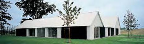


4 Standing seam quartz grey zinc roof to match colour of adjacent roofs Facades on The Front Translucent polycarbonate to entrance and canopy Rooflights Existing Site Aerial Photo Proposed Site Aerial Perspective Proposed Site Aerial Photo White through colour render system to match adjacent property Black timber cladding Alu clad timber window system 04 SCALE AND APPEARANCE

 and is proposed to be designed to an appropriate design")


5 THERMAL MODELLING The proposed new 3 classroom building to support the 1FE primary requirement has been thermal modelled using recognised software to assess against the SBEM requirements of Part L of the Building Regulations. Thermal model The calculations supports the ventilation and day light intensity requirements for the building type. SUSTAINABILITY STATEMENT The sustainability proposals for Potten End First School follow the requirements outlined in Core Strategy Policy CS29. The building has been designed to be adaptable (although it is not conceived currently that the use as Primary School classrooms will change) and is proposed to be designed to an appropriate design life as determined within the client brief. The robust and well tested materials specified consider the requirements to ensure that the whole life cycle of the building is sustainable. Materials utilised will be able to be recycled at the end of the building s life through either the product suppliers policies or through Hertfordshire County Council s waste management procedures. The design has been future proofed to enable retrofitting to meet tighter energy efficiency standards and the services proposals include a renewable energy source utilising photovoltaic panels. ENVIRONMENTAL AND SERVICES DESIGN The design strategy adopted has envisaged that the engineering services will be designed to achieve low energy use. This is achieved by maximising the use of natural and heat recovery ventilation, daylight, renewable energy and for the incorporation of simple user controls hence avoiding the use of complex automation. This approach has been supplemented by the building orientation strategy : north facing classbases and a solid southern elevation to avoid heat gain. Timber slatted brise soleil to the eastern facing feature window seat provides a dual function of limiting heat gain and screening the window away from the adjoining neighbour. Generally the ventilation will be provided by a natural ventilation strategy via opening windows above generous doors to outside facing north and using the benefits of stack ventilation through automatic rooflights to the rear of the classbases and along the circulation/break out teaching spine. Classroom daylight intensity check RENEWABLE ENERGY PROPOSALS In assessing the proposals against the Planning and Building Control guidance and legislation it is proposed to introduce an element of renewable energy source on site which will reduce the end users energy costs. The chosen system is utilisation of photovoltaic panels, installed onto the roof of the new classroom block. Photovoltaic panels harness the sun s solar energy and convert it to electricity. This electricity can be used within the building to reduce the energy imported from the grid. Based upon an available area of 48sq ms of South-facing roof and subject to detailed analysis of shading, it is estimated that the roof could accommodate up to 30 photovoltaic panels with a combined rating of 7.5kWp. Typical photovoltaic panels installation 05 ENVIRONMENTAL STRATEGY


6 Cross section through new classroom block and courtyard EXISTING AREA PROVISION PROPOSED AREA PROVISION LANDSCAPING The landscape proposals integrating the new classroom block in the existing topography will create a range of unique and defined spaces. The extent of the proposed external works will ensure minimal disturbance to existing structure while ensuring that both the new and existing buildings are suitably connected whilst providing optimum provision for passive outdoor activities. The concept of the courtyard is derived from the requirement to provide somewhere enclosed and calming which promotes educational and social uses. The mound, comprising artificial grass and the relocated commemorative tree, constitutes a central feature, a shaded lawn. The paving material is proposed as concrete paving of a natural colour to harmonise with the existing and new buildings. By contrast the swale, whilst serving as a stormwater attenuation basin, becomes a more adventurous natural environment comprising dynamic earth formations. The Arboricultural Report included within the Planning Application confirms that the existing tree located to the west of the new covered link is not affected by the proposals. In landscape terms, the site comprises disconnected green open spaces used for soft play. There are no sports pitches. There is ample provision for hard play, though these are integrated to some degree with the games courts. Soft Play Areas There are a number of soft play areas around the site, none of which are for sports or formal recreation. The largest continuous area of green open space has little or no value for sports or recreation relating to sports. Other soft play areas are located in disconnected pockets to the north and south west of the existing building. They do not relate well to existing internal spaces in terms of connectivity or function. Opportunities exist to develop external spaces that relate better with the internal functions, i.e. breakout zones adjacent to classes or subject-based education zones. Sports Pitches The school currently has no formal grass pitches and uses the nearby recreation ground for all sports requiring grass pitches. Hard Play It is not anticipated that the proposed development will impact on the existing provision of hard play areas. These are principally located around the existing games courts. Habitat The wildlife garden is in a confined and secluded location to the southwest of the site. Soft Play Areas The proposed development, comprising the new classroom block and courtyard, will be located on the largest continuous area of green open space used for soft play. This loss could be addressed by site-wide approach to develop currently under-used parcels into soft-play areas. This approach would result in a loss of 122m2 of green open space for informal play and socialising. Sports Pitches Although the site currently has a significant area of hard pitches, sports that require grass pitches are currently played on the nearby recreation ground, albeit without a formal agreement. The school is formalising the use of the nearby playing field by means of a license agreement with the Parish Council to ensure they can be used by Potten End C of E School on weekdays from 13:00 until 15:30 within school terms. Hard Play Areas The courtyard will connect the existing and proposed buildings, both having direct access to it. It will be a flexible space for educational use and group socialising. This constitutes a net gain of 288m2. Habitat The existing habitat will be re-instated at the end of the construction period. This will be extended north through the soft play area. Pockets of underused areas will be developed for biodiversity. 06 LANDSCAPE PROPOSALS
BLACKHEATH SQUASH CLUB Blackheath Sports Club, Rectory Field, Charlton Road, London, SE7 7EY. Planning, Design and Access Statement
 Planning, Design and Access Statement Revised: 28 th Jan 2016 Peter Pendleton & Associates Ltd Introduction Planning permission will be sought for a refurbishment of existing courts and extension to provide
No.2 Whitehall Riverside, Leeds July 2013
 No.2 Whitehall Riverside, Leeds July 2013 New Office_ View from Whitehall Road New Office_ Site location No.2 New Office_ Site location New Office_ Proposal in context 1 No.2 Whitehall Riverside No.1 Whitehall
CALA HO ME S WELCOME
 WELCOME Welcome to this public consultation event for our proposed residential development of 56 high quality homes on land to the north east of Station Road in Earls Colne. Thank you for taking the time
Newcourt Masterplan. November Exeter Local Development Framework
 Newcourt Masterplan November 2010 Exeter Local Development Framework Background The Exeter Core Strategy Proposed Submission sets out the vision, objectives and strategy for the development of Exeter up
Section Three, Appendix 16C Medium Density Housing, Design Assessment Criteria (Residential 8A zone)
") APPENDIX 16C MEDIUM DENSITY HOUSING, DESIGN ASSESSMENT CRITERIA (RESIDENTIAL 8A ZONE) PURPOSE OF APPENDIX 16C (RESIDENTIAL 8A ZONE) In the Residential 8A Zone the following are defined as restricted discretionary
APPENDIX 16C MEDIUM DENSITY HOUSING, DESIGN ASSESSMENT CRITERIA (RESIDENTIAL 8A ZONE) PURPOSE OF APPENDIX 16C (RESIDENTIAL 8A ZONE) In the Residential 8A Zone the following are defined as restricted discretionary
GUIDING LIGHT ASSEMBLY CHURCH MIXED-USE ARCHITECTURE
 GUIDING LIGHT ASSEMBLY CHURCH MIXED-USE Approach View BRIEF The client; Guiding Light Assembly wanted to develop a facility that would not just be used twice a week to host church services but will be
SOUTH CAMBRIDGESHIRE DISTRICT COUNCIL. Executive Director (Operational Services) Corporate Manager (Planning and New Communities)
 Corporate Manager (Planning and New Communities)") SOUTH CAMBRIDGESHIRE DISTRICT COUNCIL REPORT TO: Planning Committee 12 January 2011 AUTHOR/S: Executive Director (Operational Services) Corporate Manager (Planning and New Communities) Notes: S/1848/10
SOUTH CAMBRIDGESHIRE DISTRICT COUNCIL REPORT TO: Planning Committee 12 January 2011 AUTHOR/S: Executive Director (Operational Services) Corporate Manager (Planning and New Communities) Notes: S/1848/10
St Barnabas C of E Primary School, Spring Lane, Erdington, Birmingham, B24 9BY
 Committee Date: 12/06/2014 Application Number: 2014/02967/PA Accepted: 29/04/2014 Application Type: Full Planning Target Date: 24/06/2014 Ward: Erdington St Barnabas C of E Primary School, Spring Lane,
Housing Development at Balloonagh Tralee Co Kerry
 Design Statement Housing Development at Balloonagh Tralee Co Kerry Area of site 10,400m2 24 houses-12no 3 bed, 12no 2 bed and 4 single bed apartments total residential area of 2411m2 Open space provided
Derry City and Strabane District Council Planning Committee Report
 Derry City and Strabane District Council Planning Committee Report COMMITTEE DATE: 23 rd March 2016 APPLICATION No: APPLICATION TYPE: PROPOSAL: LOCATION: APPLICANT: LA11/2015/0395/F Residential Development
10 Proposed Redevelopment, Tewkesbury Road, Cheltenham SCHEME EVOLUTION STARBUCKS
 SCHEME EVOLUTION STARBUCKS The proposed Starbucks Drive Thru alongside the proposed food store provides an appropriate mix of uses, suitable for this location. The proposed store is bespoke, designed specifically
PDP DESIGN & ACCESS STATEMENT
 PDP The Planning & Design Partnership Planning.. Architecture.. Interiors.. Landscape The Chicory Barn Studio, The Old Brickyards, Moor Lane, Stamford Bridge York, The East Riding Of Yorkshire, YO41 1HU.
4 Residential and Urban Living Zones
 4 Residential and Urban Living Zones Refer to Chapters 11 to 20 for additional rules that may apply to these zones. 4.1 OBJECTIVES AND POLICIES Objective Res1 Policy 1 Policy 2 Policy 3 Policy 4 Policy
Please take time to view our latest plans, speak to the development team and ask any questions you may have. EALING BROADWAY A4020
 WELCOME Durston House School is a successful school in the heart of Ealing. With 90 per cent of our pupils living in the borough, we have a strong connection to the local area. We are proposing to consolidate
A New Aldi Foodstore Hesketh Bank Tarleton Banks A59 The proposed site A565 Croston Former Bayleaf Restaurant Holmes A59
 A New Aldi Foodstore Hesketh Bank Tarleton Banks A565 The proposed site A59 Croston Holmes Former Bayleaf Restaurant A59 Aerial view of the site Aldi is keen to provide the local community with more choice
Section Three, Appendix 17C Multiple Unit Housing Design Assessment Criteria
 APPENDIX 17C MULTIPLE UNIT HOUSING DESIGN ASSESSMENT CRITERIA Purpose of Appendix 17C In the Residential 9 Zone the construction and use of multiple household units located within the Multiple Household
4. MASTERPLAN FRAMEWORK
 6a 6b 4. MASTERPLAN FRAMEWORK 6. Car Parks 6c Car Parks 6a and 6b will provide permanent parking. Area 6a will serve the foodstore with tarmac surfacing within a defined area to the west of the adjacent
DESIGN & ACCESS STATEMENT
 DESIGN & ACCESS STATEMENT Land to the South East of the A495, Bronington Erection of 31 Dwellings (27 dwellings and 4 bungalows including 4 Affordable Dwellings), Realignment and Improvements to A495 (including
6 Site Framework Strategies
 6 Site Framework Strategies 6.1 Introduction Section 6 identifies a number of specific areas which are considered to be key sites within the Plan area and which may have potential for development / redevelopment.
Proposed for Vic West Neighbourhood Plan. Design Guidelines for Intensive Residential Development - Townhouse and Attached Dwelling
 Proposed for Vic West Neighbourhood Plan Design Guidelines for Intensive Residential Development - Townhouse and Attached Dwelling Design Guidelines for Intensive Residential Development - Townhouse and
3.1 The hybrid planning application proposes the following description of development:
 CHAPTER 3: PROPOSED DEVELOPMENT 3.1 The hybrid planning application proposes the following description of development: Hybrid (part-outline/part-full) planning application for a single composite development
Persimmon Homes Thames Valley Date received: 2 nd April week date(major): 2 nd July 2014 Ward: Nascot
: 2 nd July 2014 Ward: Nascot") PART A Report of: DEVELOPMENT MANAGEMENT SECTION HEAD Date of Committee: 26 th June 2014 Site address: Rounton, 28, Nascot Wood Road Reference Number: 14/00497/REM Description of Development: Reserved
PART A Report of: DEVELOPMENT MANAGEMENT SECTION HEAD Date of Committee: 26 th June 2014 Site address: Rounton, 28, Nascot Wood Road Reference Number: 14/00497/REM Description of Development: Reserved
Welcome to our exhibition
 Welcome to our exhibition The Homes & Communities Agency (HCA) welcomes you to this public exhibition explaining our proposals for the redevelopment of the former Lea Castle Hospital site. About the Homes
doyle + o troithigh landscape - architecture
 doyle + o troithigh landscape - architecture REPORT: PROJECT: LANDSCAPE DESIGN REPORT. STUDENT HOUSING DEVELOPMENT AT WESTWOOD HOTEL SITE. DATE: MAY 2018. www.doyle-otroithigh.com Landscape design report,
Chapter 2: OUTLINE PLANNING APPLICATION PROPOSALS. A New Garden Neighbourhood Matford Barton 17
 Chapter 2: OUTLINE PLANNING APPLICATION PROPOSALS A New Garden Neighbourhood Matford Barton 17 2.1. SUMMARY AND STATUS OF THE PROPOSALS 2.1.1. The parameter plans and associated wording in this chapter
Warren Farm, Ampthill
 1 Welcome The developers of the Warren Farm site, Bloor Homes and Connolly Homes, are holding this exhibition on the emerging Design Codes for the development prior to their formal submission to Central
Perth and Kinross Council Development Management Committee 20 February 2013 Report of Handling by Development Quality Manager
 Perth and Kinross Council Development Management Committee 20 February 2013 Report of Handling by Development Quality Manager 4(4)(iii) 13/81 Erection of sports hall, associated changing facilities, offices
DESIGN & ACCESS STATEMENT. REVISION A Residential Development, Neon Social Club, Nairn Street, Jarrow.
 DESIGN & ACCESS STATEMENT. REVISION A Residential Development, Neon Social Club, Nairn Street, Jarrow. The following Design & Access Statement is in support of a Full Planning Application for a residential
Section 4 - Public Realm & Landscape proposals Landscape Masterplan. Section 4 52
 - Public Realm & Landscape proposals Landscape Masterplan 52 Proposed Masterplan - Green Infrastructure Strategy District Park 4.33 Ha to provide Passive and active recreation with a large play area which
Background Information
 Background Information view at site entrance THE LONDON BOROUGH OF SUTTON As the strategic local authority the Council is working with a range of partners to take forward various development sites in Hackbridge.
design & access statement Proposed Erection of 68 Bedroom Hotel and Restaurant with Associated Landscaping
 Proposed Erection of 68 Bedroom Hotel and Restaurant with Associated Landscaping Promenade, design & access statement lawrencemcphersonassociates 6 new road, ayr, ka8 8ex On Behalf of July 2015 CONTENTS
INVESTING IN WATERWAYS
 1 H2O Urban LLP is a joint venture vehicle between developers Bloc and British Waterways which specialises in regenerating canalside locations. aerial view of site The redevelopment of the site would generate
I615. Westgate Precinct
 I615. Westgate Precinct I615.1. Precinct Description The Westgate Precinct is located approximately 18km west of the Auckland city centre. There are seven Sub-precincts in the Westgate Precinct: Sub-precinct
Subdivision Design Criteria. Penihana North GUIDELINES TO THE RULES
 Created September 2013 Penihana North Subdivision Design Criteria GUIDELINES TO THE RULES This part of the Plan sets out the design criteria for subdivision in Penihana North. The criteria will be considered
3.0 master plan concept
 3.0 master plan concept 3.1 introduction The purpose of the Huron Church Road Master Plan Concept is to provide an overview of the Master Plan design process, identify preliminary streetscape installations
Carleton University. Nicol Building New Sprott School of Business. Design Brief and Planning Rationale. Carleton University
 Carleton University Nicol Building New Sprott School of Business Design Brief and Planning Rationale Carleton University Design Team Proposal New Sprott School of Business Academic Building 2019 October
Statement of Community Involvement LAND OFF SOUTHDOWN ROAD HORNDEAN, HAMPSHIRE
 LAND OFF SOUTHDOWN ROAD HORNDEAN, HAMPSHIRE CONTENTS Page 1. Introduction 3 2. Pre-application Discussions 4 3. The Consultation Process 5 4. Consultation Feedback 7 5. Responses to Consultation Feedback
YMCA Erdington (Phase 2), 300 Reservoir Road, Erdington, Birmingham, B23 6DB
, 300 Reservoir Road, Erdington, Birmingham, B23 6DB") Committee Date: 13/06/2013 Application Number: 2013/03011/PA Accepted: 30/04/2013 Application Type: Full Planning Target Date: 30/07/2013 Ward: Stockland Green YMCA Erdington (Phase 2), 300 Reservoir Road,
Committee Date: 13/06/2013 Application Number: 2013/03011/PA Accepted: 30/04/2013 Application Type: Full Planning Target Date: 30/07/2013 Ward: Stockland Green YMCA Erdington (Phase 2), 300 Reservoir Road,
Welcome to our public exhibition
 About our development Welcome to our public exhibition This exhibition gives you the chance to view and comment on our proposals for a new residential development of 165 high-quality homes, along with
PLANNING COMMITTEE. 14 October 2014
 AGENDA ITEM NO 8 PLANNING COMMITTEE 14 October 2014 APPLICATION NUMBER : CA//14/01744/FUL PROPOSAL : Extension and conversion of roof space of an existing detached bungalow together with enhanced parking
MKEA Zuccoli School Master Plan Landscape and External Areas. D Issue C 02/08/2017
 MKEA Zuccoli School Master Plan Landscape and External Areas D16-0056 Issue C 02/08/2017 LEGEND Zuccoli Parade Bus Stop Large Shade Trees Medium Shade Trees 10m Green Buffer Zone Garden Bed Areas Preschool
WELCOME. Olney Road, Lavendon INTRODUCTION. The Site. The Application. The Need for Housing. A Sustainable Location LAVENDON TURVEY OLNEY ROAD
 0 WELCOME INTRODUCTION Gladman Developments Ltd have successfully invested in communities throughout the UK over the past 0 years, developing high quality and sustainable residential, commercial and industrial
SCHEDULE 12 TO THE DESIGN AND DEVELOPMENT OVERLAY GLEN WAVERLEY ACTIVITY CENTRE STRUCTURE PLAN
 DD/MM/YY Proposed C120 SCHEDULE 12 TO THE DESIGN AND DEVELOPMENT OVERLAY Shown on the planning scheme map as DDO12. GLEN WAVERLEY ACTIVITY CENTRE STRUCTURE PLAN 1.0 Design objectives DD/MM/YY Proposed
97 Lea Bridge Road, Leyton, E10 7QL London Borough of Waltham Forest December 2015
 97 Lea Bridge Road, Leyton, E10 7QL London Borough of Waltham Forest December 2015 Public Realm and Landscape Proposals LEA BRIDGE ROAD, WALTHAMSTOW Public Realm & Landscape Proposals BDP(90)RPT001 December
Welcome. Site/11/04. Site/11/03. Proposed Site. 11,400 new homes needed in east Cambs
 Welcome Welcome to our consultation on our proposals for new homes on land north east of Soham Road, Fordham. Members of the project team are available to answer any questions you have and listen to feedback.
8.0 Design and Form of Development 43/
 42/ 8.0 Design and Form of Development 43/ Rothwells Farm, Golborne/ Development Statement Figure 7. Site Constraints Key 44/ Site Boundary 360 Bus Route/Stops Existing Trees Underground Water Pipe Sensitive
RIVERSIDE DESIGN CD-1 GUIDELINES. Adopted by City Council August 9, 1983
 $1 City of Vancouver Land Use and Development Policies and Guidelines Community Services, 453 W. 12th Ave Vancouver, BC V5Y 1V4 F 604.873.7344 fax 873.7060 planning@city.vancouver.bc.ca RIVERSIDE DESIGN
Chapter 5 Urban Design and Public Realm
 5.1 Introduction Public realm is all areas of the urban fabric to which the public have access. It is where physical interaction takes place between people. It therefore, includes buildings and their design,
DEMOLITION OF EXISTING BUNGALOW AND REPLACEMENT BUNGALOW. Ms Sukhi Dhadwar
 SITE PLAN ATTACHED 04. HIGH POINT BEGGAR HILL FRYERNING ESSEX CM4 0PN DEMOLITION OF EXISTING BUNGALOW AND REPLACEMENT BUNGALOW. APPLICATION NO: 15/00315/FUL WARD Ingatestone, Fryerning & Mountnessing 8/13
22.15 OUTDOOR ADVERTISING SIGNAGE POLICY
 22.15 OUTDOOR ADVERTISING SIGNAGE POLICY This policy applies to all land where a planning permit is required to construct or display a sign under the provisions of the Kingston Planning Scheme. 22.15-1
TRAFALGAR PLACE LONDON
 January 2017 Uniclass L534:L217 Award-winning and Stirling Prize shortlisted Urban regeneration high density housing scheme Exemplary public realm with precast concrete paving Careful detailing carried
CHAPTER 13 DESIGN GUIDELINES
 CHAPTER 13 DESIGN GUIDELINES Section 1300.00 Section 1300.01 Design Guidelines Purpose The purposes of this section are to: A. The purpose of this Section is to establish procedures and standards to serve
DONCASTER METROPOLITAN BOROUGH COUNCIL. PLANNING COMMITTEE - 15th October Expiry Date:
 DONCASTER METROPOLITAN BOROUGH COUNCIL PLANNING COMMITTEE - 15th October 2013 Application 3 Application Number: 13/01158/FUL Application Expiry Date: 31st July 2013 Application Type: Full Application Proposal
Linden Homes Proposals for land off Ringwood Road, Verwood
 Welcome Welcome to Linden Homes first public exhibition displaying proposals for new homes on land off Ringwood Road in Verwood. Award-winning house builder Linden Homes, part of the Galliford Try Group,
medium desnity housing
 This section updated September 2013 This part of the Plan sets out the assessment criteria for medium density housing. The criteria are designed to give designers and builders flexibility and to provide
Community Design Guidelines. Port Wallace DRAFT
 Community Design Guidelines Port Wallace DRAFT Energy 1 2 3 Nature Movement Connections Built Form DRAFT Layout Energy 1 Nature Community Design Guidelines GREAT COMMUNITIES PROTECT, CELEBRATE, AND CONSERVE
PROPOSED RESIDENTIAL DEVELOPMENT LAND AT TRETHURFFE LADOCK, TRURO Design & Access Statement
 PROPOSED RESIDENTIAL DEVELOPMENT LAND AT TRETHURFFE LADOCK, TRURO Design & Access Statement Heron Way, Newham, Truro, Cornwall, TR1 2XN Tel: 08453 707 111 Fax: 08453 707 113 www.csa-architects.co.uk E:
SCHEDULE THREE TO THE DEVELOPMENT PLAN OVERLAY EASTERN GOLF COURSE KEY REDEVELOPMENT SITE
 DD/MM/YY SCHEDULE THREE TO THE DEVELOPMENT PLAN OVERLAY Shown on the planning scheme map as DPO3 EASTERN GOLF COURSE KEY REDEVELOPMENT SITE 1.0 A permit may be granted before a development plan has been
New Street Proposed Redevelopment Architecture & Urban Design Brief
 2130 2136 New Street Proposed Redevelopment Architecture & Urban Design Brief Prepared By: Cynthia Zahoruk Architect Inc. 3077 New Street, Burlington, ON, L7N 1M6 TABLE OF CONTENTS Background and Objective
Nelson Residential Street Frontage Guideline
 DRAFT 22-06-2012 Nelson Residential Street Frontage Guideline June 2012 1317273 Contents and purpose Residential s are important Residential s are much more than corridors which move traffic. Streets allow
Former Temple Cowley Pools, Oxford TEMPLE COWLEY LIBRARY * ELEVATION SHOWN IS INDICATIVE AND SUBJECT TO FINAL DESIGN AND AGREEMENT.
 OPEN SPACE TEMPLE COWLEY LIBRARY library beyond Proposed apartments Proposed apartments Proposed houses Temple Road * ELEVATION SHOWN IS INDICATIVE AND SUBJECT TO FINAL DESIGN AND AGREEMENT. * Welcome
LONGDEN VILLAGE DEVELOPMENT STATEMENT
 LONGDEN VILLAGE DEVELOPMENT STATEMENT 2017-2027 1 Longden Development Statement 2017-2027 15/01/18 1. Background 1.1 Longden Village Longden village is a very rural and traditional community first mentioned
Bel-Air Lexus Automobile Service Station
 Bel-Air Lexus Automobile Service Station Design Brief 443-447 McArthur Avenue Ottawa April 30, 2015 14-1299-MCA Site Details Application: Site Plan Control Legal Description and Municipal Addresses: 443
A NEW LOOK FOR THE BISHOP CENTRE. Land Securities. Our environment. Our communities
 Welcome Welcome to this exhibition of our new plans for redeveloping the Bishop Centre. If you have any questions please ask a member of the project team - we look forward to hearing your views. Land Securities
FANLING CROWN ESTATE OXSHOTT, SURREY
 FANLING CROWN ESTATE OXSHOTT, SURREY Contents 1.0 Existing House and Gardens 1.1 Intial Design Concept 2.0 Ground fl oor Plan 2.1 First Floor Plan 2.2 Proposed Sections 3.0 The Entrance 3.1 The Dining
Mortimer NDP, Principles, Vision and Policies
 The Three Principles Mortimer NDP, Principles, Vision and Policies 1. The NDP must make it possible for people to live the whole of their lives in the parish if they so wish 2. 2. The NDP will ensure that
SOUTH CAMBRIDGESHIRE DISTRICT COUNCIL. Planning and New Communities Director
 SOUTH CAMBRIDGESHIRE DISTRICT COUNCIL REPORT TO: Planning Committee 5 June 2013 AUTHOR/S: Planning and New Communities Director S/0747/13/FL HISTON Construction of Car Park at Histon Baptist Church, Station
OVERVIEW PROJECT SUMMARY
 OVERVIEW These five houses on Ridge View Crescent form an important part of the wider Anslemi Ridge development. They are the backdrop to the lake that is the community heart of the nieghbourhood, and
an Inspector appointed by the Secretary of State for Communities and Local Government
 Appeal Decision Site visit made on 11 October 2016 by Mike Hayden BSc DipTP MRTPI an Inspector appointed by the Secretary of State for Communities and Local Government Decision date: 21 November 2016 Appeal
WHITELEY TOWN COUNCIL NORTH WHITELEY DEVELOPMENT SEPTEMBER 2014
 WHITELEY TOWN COUNCIL NORTH WHITELEY DEVELOPMENT SEPTEMBER 2014 Dear Resident This Special Edition of the Whiteley Voice which has been prepared in conjunction with the North Whiteley Consortium is to
H7 Open Space zones. (a) provide for the needs of the wider community as well as the needs of the community in which they are located;
 provide for the needs of the wider community as well as the needs of the community in which they are located;") H7. Open Space zones H7.1. Background The majority of land zoned as open space is vested in the Council or is owned by the Crown. However some areas zoned open space are privately owned. While the open
H7. Open Space zones H7.1. Background The majority of land zoned as open space is vested in the Council or is owned by the Crown. However some areas zoned open space are privately owned. While the open
4 RESIDENTIAL ZONE. 4.1 Background
 4 RESIDENTIAL ZONE 4.1 Background The residential areas within the City are characterised by mainly lowrise dwellings sited on individual allotments. Past architectural styles, settlement patterns and
CAERNARFON DEPENDENCY CATCHMENT AREA
 CAERNARFON DEPENDENCY CATCHMENT AREA GWYNEDD UNITARY DEVELOPMENT PLAN - HOUSING Map not to scale Dependency Catchment Area Location 2 Caernarfon Topic Housing To the rear of Bro Eglwys, Bethel. Grid Ref.
A NEW ALDI FOOD STORE FOR KINGS NORTON
 Welcome A NEW ALDI FOOD STORE FOR KINGS NORTON to our exhibition Aldi, the award-winning discount food retailer, is bringing forward plans to redevelop land off Redditch Road in. We are proposing a food
APPENDIX MATAKANA COMMERCIAL URBAN DESIGN GUIDELINES
 APPENDIX MATAKANA COMMERCIAL URBAN DESIGN GUIDELINES 1.0 INTRODUCTION The following urban design guidelines are to be utilised by landowners, planners and other persons involved in development at early
I539. Smales 2 Precinct
 I539. Smales 2 Precinct I539.1. Precinct Description The Smales 2 Precinct applies to a 4.8 hectare block of land located on the southern side of Northcote Road and fronting Lake Pupuke, Takapuna. The
URBAN DESIGN BRIEF. 2136&2148 Trafalgar Road. Town of Oakville
 URBAN DESIGN BRIEF 2136&2148 Trafalgar Road Town of Oakville Prepared By: METROPOLITAN CONSULTING INC For 2500674 Ontario Inc November 2016 TABLE OF CONTENTS Page No. 1.0 Introduction/Description of Subject
CAMPUS MASTER PLAN UPDATE
 13 April 2016 CAMPUS MASTER PLAN UPDATE Focus Group Landscape AGENDA What We Heard Review of Campus Observations & Analysis Campus Framework & Open Space Network Table-Top Exercise Landscape Guideline
Woodbrook - Shanganagh
 Section 4: Key Sites Framework Strategy Woodbrook - Shanganagh Local Area Plan 2017-2023 4. Site Framework Strategies The Master Plans shall have regard to the thematic objectives under the LAP Development
AOTEA SUPERMARKET ZONE. Zone Introduction
 C18 AOTEA SUPERMARKET ZONE Zone Introduction C18.1 Objective This zone identifies a specific area in Aotea for a stand alone supermarket. The zone is site specific and has a range of objectives, policies
Proposals A R C H I T E C T S. Tibbalds MJP Architects PCKO Architects Allen Pyke Associates Waterman Group Aedas R&D
 GMV Proposals A R C H I T E C T S Tibbalds MJP Architects PCKO Architects Allen Pyke Associates Waterman Group Aedas R&D Masterplanning concept... the building block... Our Team the individual unit......implementation
Clairtrell Area Context Plan
 Clairtrell Area Context Plan March 2005 Urban Development Services City Planning Contents 1. Introduction... 4 2. Development Structure... 6 2.1 Streets... 7 2.1.1 Sheppard Avenue and Bayview Avenue...
Page 1 of 19 URBAN DESIGN FRAMEWORK FOR BOLTON STREET WATERFORD
 Page 1 of 19 URBAN DESIGN FRAMEWORK FOR BOLTON STREET WATERFORD 1.0 Introduction: The relocation of the City Council stores and depot from Bolton Street creates an exciting opportunity for development
6.0 Land Use Policies for Rural Settlements. 6.1 Rural Settlement Strategy
 6.0 Land Use Policies for Rural Settlements 6.1 Rural Settlement Strategy INTRODUCTION AMENDMENT NO. 131 PURPOSE Designated rural settlements comprise Rural Clusters, Villages and Serviced Villages as
Land at Rampton Road. Cottenham
 Land at Rampton Road Cottenham Introduction TEP is preparing an outline planning application for 54 dwellings on 6.9 hectares of land adjacent to Rampton Road, Cottenham on behalf of the owners Cambridgeshire
St Marys Church Of England High School Downage London NW4 1AB
 Location St Marys Church Of England High School Downage London NW4 1AB Reference: 16/2877/FUL Received: 29th April 2016 Accepted: 10th May 2016 Ward: Hendon Expiry 5th July 2016 Applicant: Proposal: Governors
Story Homes. Land at Thirsk Road, Kirklevington. An Introduction to Story Homes. Our Foundations. Commitment to Consultation.
 Story Homes An Introduction to Story Homes Founded by Fred Story in 1987, Story Homes has a long and successful reputation of building high quality and high specification homes. The family owned business
Linden Homes Proposals for Havant Retail Park, Portsdown Hill Road, Bedhampton. Welcome
 Welcome Welcome to Linden Homes public exhibition in connection with its proposals for a range of high quality new open market, affordable homes and open space on the site of the Havant Retail Park. Today
WINDSOR GLEN DESIGN GUIDELINES
 WINDSOR GLEN DESIGN GUIDELINES Adopted by Council, 2006 WINDSOR GLEN REDEVELOPMENT DESIGN GUIDELINES August 2006 1.0 Master Plan Organization For this area of the Coquitlam Town Centre, a mix of high,
Carton Avenue Action Area Plan Maynooth
 Carton Avenue Action Area Plan Maynooth Kildare County Council JULY 2006 (AAP) Table of Contents Section 1. Introduction...3 Statement of Strategy...3 Location of the Lands...3 Context in the Town Development
GREENBANK DEVELOPMENT MASTERPLAN
 DEVELOPMENT MASTERPLAN POTENTIAL TRAIN STATION COMMUNITY CENTRE Greenbank will be a connected masterplanned community providing easy access to local and surrounding amenity. Affordable quality homes, green
DESIGN GUIDELINES Building and Siting Requirements
 DESIGN GUIDELINES Building and Siting Requirements DESIGN GUIDELINES BUILDING AND SITING REQUIREMENTS // LEWIS LAND GROUP 2016 2 CONTENTS INTRODUCTION... 05 IMPORTANT CONSIDERATIONS... 06 YOUR HOUSE...
St Michaels C of E Junior & Infant School, Nantmel Grove, Bartley Green, Birmingham, B32 3JS
 Committee Date: 06/03/2014 Application Number: 2013/08595/PA Accepted: 19/11/2013 Application Type: Full Planning Target Date: 14/01/2014 Ward: Bartley Green St Michaels C of E Junior & Infant School,
Cape Cabarita (Formerly known as the Wellcome Site) Development Control Plan. Date of Adoption: 4 September 2007 Effective Date: 7 March 2008
 Development Control Plan. Date of Adoption: 4 September 2007 Effective Date: 7 March 2008") Cape Cabarita (Formerly known as the Wellcome Site) Development Control Plan Date of Adoption: 4 September 2007 Effective Date: 7 March 2008 Development Control Plan Index 1 INTRODUCTION...3 1.1 LAND TO
Cape Cabarita (Formerly known as the Wellcome Site) Development Control Plan Date of Adoption: 4 September 2007 Effective Date: 7 March 2008 Development Control Plan Index 1 INTRODUCTION...3 1.1 LAND TO
PLANNING COMMITTEE DATE: 07/09/2015 REPORT OF THE SENIOR MANAGER PLANNING AND ENVIRONMENT SERVICE CAERNARFON. Number: 4
 Number: 4 Application Number: C15/0034/37/LL Date Registered: 21/05/2015 Application Type: Full - Planning Community: Llanaelhaearn Ward: Llanaelhaearn Proposal: Location: Summary of the Recommendation:
1. Local Plan Context
 1. Local Plan Context WHY ARE YOU HERE? ABOUT US PLANNING APPLICATION CONSULTATION Stewart Milne Homes are in the process of preparing a detailed planning application for a development of approximately
Residential Development at Menehay Farm, Bickland Water Road, Falmouth Design and Access Statement
 Residential Development at Menehay Farm, Bickland Water Road, Falmouth Design and Access Statement Galliford Try STRIDE TREGLOWN JOB NO. PREPARED BY CHECKED BY DATE REVISION REVISION NO. 150220 Coral Ducroq
HALF MOON BAY CATHOLIC ELEMENTARY SCHOOL SITE PLAN CONTROL DESIGN BRIEF
 HALF MOON BAY CATHOLIC ELEMENTARY SCHOOL SITE PLAN CONTROL DESIGN BRIEF February 12, 2015 BRYDEN MARTEL ARCHITECTS INCORPORATED 1066 somerset street west, suite 200, ottawa, ontario K1Y 4T3 tel: (613)
Stoke Newington High Street 1.0 Site Analysis
 1.0 Site Analysis 9-11 Stoke Newington Church Street Grade II Existing Entrance via Wilmer Place Stoke Newington Church Street 187-191, 18th C; Grade II* including forecourt wall, railings and gates Rights
Northern Territory Compact Urban Growth Policy
 Northern Territory Compact Urban Growth Policy A Reference Policy Document to clause 2.7 (Reference to Policy) of the NT Planning Scheme May 2015 Table of Contents 1 Policy Setting... 3 1.1 Context for