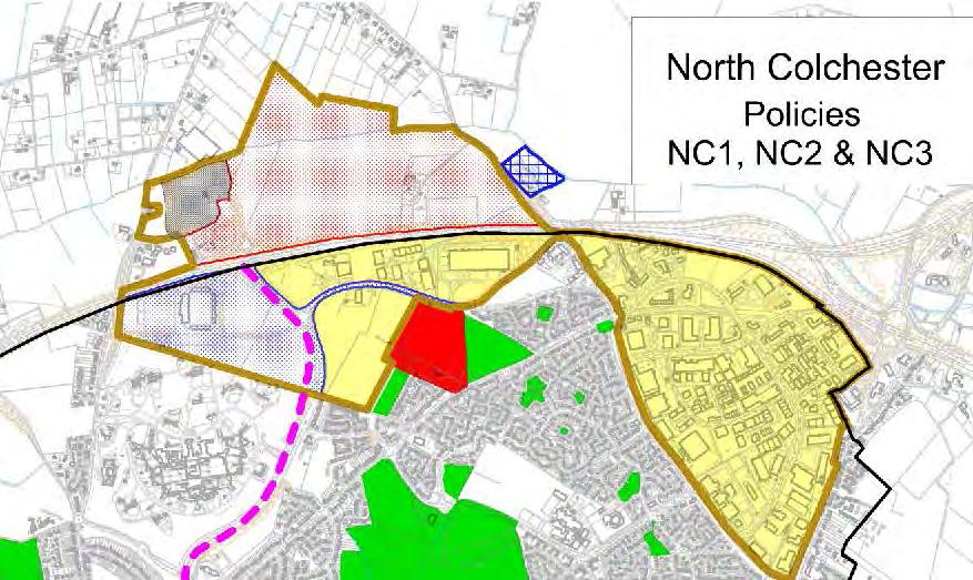
Colchester Northern Gateway Master Plan Vision Review Draft. July 2016
|
|
|
- Lorin Gray
- 5 years ago
- Views:
Transcription
1 Colchester Northern Gateway Master Plan Vision Review Draft July 2016
2 Contents Introduction 4 Context 8 Purpose of the Report 8 Strategic Position 9 Overview of the Process Master Plan Vision 12 Emerging Southern Site Framework 13 Reviewed Master Plan Principles 14 Key Principles 18 Reviewed Master Plan Concept 18 Master Plan Elements 20 Master Plan Plots 27 Buildings and Views 28 Zones and Local Amenities 30
3 Design Guidance 36 General Height 36 Hierarchy of Frontage 37 Public Open Space Hierarchy 38 Pedestrian Circulation 40 Vehicular Circulation 42 Zone by zone Character Areas 46 Colchester Local Plan Preferred Options 46 Sport and Recreation 48 Commercial Leisure 49 Employment and Mixed Uses 50 Homes 51 Conclusion 53 3
4 Introduction This Master Plan review for Colchester Northern Gateway has been prepared by Gillespies on behalf of Colchester Borough Council. Colchester Northern Gateway will play an important role in the growth of Colchester into an increasingly competitive place, with a diversified offer. The vision is for a vibrant, accessible, green, leisure orientated mixed use location. It will be characterised by a mix of leisure uses, green surrounding and a civic heart to provide focus and to unify the community and visitors. The intention is to create a new sustainable destination that promotes growth and investment for the entirety of Colchester. The Council has been working with Gillespies to prepare a public realm and urban design strategy for the whole of the Northern Gateway. The aim is to provide a parkland and informal recreation setting for the informal sports facilities on the Northern side of the A12 and a masterplan strategy of commercial and employment uses on the Southern side. 4 Colchester Northern Gateway

5 N The Site - Colchester Northern Gateway covers an area of approximately 112ha. the aerial photo above of CNG is been taken in 2014 Master plan Strategy 5
6 Context
7 Purpose of the Report Strategic Position Overview of the Process 2012 Master Plan Vision Emerging Southern Site Framework Reviewed Master Plan Principles

8 Context Purpose of the Report This report represents a review of the existing Master Plan Vision for the Northern Gateway, originally published in June 2012 by the Colchester Borough Council. The report suggests a broad set of design principles but does not have status or weight in planning terms. The report has the following objectives: To present a review of the masterplan vision produced in To identify the urban design and landscape principles and key moves which will achieve this vision and create a distinctive location. To define a broad master plan framework as a basis for the development of more detailed proposals 8 Colchester Northern Gateway

9 Context Strategic Position The adjacent plan highlights the strategic position of Northern Gateway within Colchester. The site is situated to the immediate south and north of the A12 which provides an important link to London and Ipswich. Sudbury Ipswich The Park and Ride facility provides a direct connection through Northern Gateway to the railway stations and the town centre.. Northern Gateway has been promoted for development by the Council for a number of years. Now that proposals for Severalls Hospital are underway there is an even greater emphasis on the creation of a distinctive, high quality development which contributes to the identity and role of North Colchester. London Park and Ride A12 Severalls Industrial Park Former Severalls Hospital Mile End N Main Urban Links Town Centre Master plan Strategy 9

10 Context Strategic Position In addition to excellent road links, Northern Gateway also benefits from connections to an established network of green routes, parks and wild spaces, north to the Essex Way, and south to the town centre via High Woods Country Park It is conveniently located in close proximity to large green areas, which makes it an ideal linking point between Colchester and its green surrounding. It is walking distance from High Woods Country Park, as well as green farmlands and fields to the north of the A12. Farmland A12 High Woods CoUNtry Park N Main Pedestrian Links 10 Colchester Northern Gateway
11 Context Overview of the Process 2012 MASTER PLAN A number of key moves have been identified in the previous Vision for the Northern Gateway: Respond to the existing landscape structure Establish a central boulevard which unifies Northern Gateway Use planting to reinforce spaces and connections Promote a sustainable movement strategy Establish flexible and accessible building plots Define a clear framework for key buildings, spaces and views This master plan review will endeavour to preserve the key moves where possible EMERGING SOUTHERN SITE FRAMEWORK Since publication of the Master Plan Vision in 2012, some plots on the site have been granted planning permission. The layout of these developments is not in line with the Master Plan Vision, creating a new situation on the site. Further changes since the Master Plan Vision published in 2012 include: the decision to keep the roundabout on Via Urbis, which is contrary to the Master Plan Vision the decision to include the site north of A12 into the master plan, predominantly by moving the Rugby Club to the north of A12. Master plan Strategy 11


12 Context 2012 Master Plan Vision N The diagram above is been extracted from the draft framework document prepared by consultants Allies and Morrison Urban Practitioners who were commissioned to undertake the masterplanning exercise and design led workshop with officers during October and November 2011, followed by public consultation in Colchester Northern Gateway


13 Context Emerging Southern Site Framework N The diagram above shows the emerging urban framework of the southern site dated July 2016 Master plan Strategy 13
14 Context Reviewed Master Plan Principles The new site configuration, created by new developments and the decision to retain the roundabout limits the key move from the 2012 Vision of establishing the Central Boulevard from being established. To adapt and retain the idea of Allies and Morrison Central Boulevard it is proposed to establish a two part central spine, comprising of The Boulevard to the east, and the Leisure Promenade to the west. A generous public plaza on either side of the roundabout should be created where these two intersect. the Boulevard leisure promenade Hedgerow / woodland future Green Link the circus Where possible, it is recommended to retain the existing hedgerows, and follow their lines in any future division of the site into plots. 14 Colchester Northern Gateway

15 adopted principles upon the emerging situation N Master plan Strategy 15
16 Key Principles
17 Reviewed Master Plan Concept Master Plan Elements Master Plan Plots Buildings and Views Zones and Local Amenities


18 Key Principles Reviewed Master Plan Concept CNG master plan strategy aims to provide coherent and clear links between the parkland, sport and informal recreational area in the North to the southern commercial and leisure At the intersection of the Leisure Promenade and the Boulevard, close to the new public space we called The Circus, a new leisure trail will lead north toward the Rugby Centre and south towards the High Woods Country Park. The leisure trail will benefit from new landscaping, with clearly signposted leisure destinations along it, spanning the site both south and north of the A12. Secondary green links, to more leisure destinations, and potentially water based leisure activities is planned to the east of the site, linking the new village green with the recreational to the north of the A12. Public realm should form a backbone to the development, with focal areas capable of acting as informal community spaces. The master plan strategy delivers appropriate site - wide sustainability measures from sustainable drainage systems (SUDs) to sustainable development forms Leisure Promenade the Boulevard 18 Colchester Northern Gateway

19 N reviewed master plan concept Master plan Strategy 19

20 Key Principles Master Plan Elements following existing hedgerows Respond to the existing landscape structure: it is the aim to preserve as many of the established hedgerows on the site as possible, and to orientate development plots in a way to allow pedestrian and cycle routes along these hedgerows. N 20 Colchester Northern Gateway

21 leisure promenade + the boulevard Due to new constraints and the already emerging leisure orientated nature of the western part of the site, the central spine should have two clearly distinguished corridors: the leisure promenade which will be focused on the movement and the boulevard which will be focused on the place. The western part of the spine will constitute a Leisure Promenade, with a more open feel to it, while the eastern part will form the newly established Boulevard with clearly defined building frontages and open spaces. N Master plan Strategy 21

22 Key Principles Master Plan Elements circulation vehicular and pedestrian The Boulevard should have clearly defined frontages creating a more urban feel than the differently landscaped less dense leisure promenade. New prominent artworks should be located on the bridge over A12 and should be designed to be taller than the surrounding buildings and visible from some distance. main vehicular main pedestrian N 22 Colchester Northern Gateway

23 reducing density + permeating landscape Create a logical framework for residential, leisure and landscape elements The building height should increase in the southeastern area, gradually reducing towards the north-west in order to allow the green landscape to permeate, especially amongst the leisure-orientated developments. N Master plan Strategy 23

24 Key Principles Master Plan Elements walking distance The movement strategy for the Colchester Northern Gateway is envisaged in such a way as to provide plenty of opportunities for walking, cycling and jogging. The network will serve not only to aid the connectivity on the site, but also to be used for recreation, reinforcing the identity of the Northern Gateway as a leisure destination N 24 Colchester Northern Gateway
25 New BUS - ROUtes AND BUS STOPS The master plan incorporates the bus stops location pattern which will be considered by standard spacing and walking distance. The optimal spacing between bus stops involves a balance of customer convenience and operating efficiency. The location of the new bus stops will be negotiated with the Council and bus operators BUS PARK AND RIDE bus routes 2, 80, 80A new bus stops existing bus stops 11 8, 61, 65, 68, 81, 81A N 8, 61, 65, 68, 81, 81A Master plan Strategy 25

26 Key Principles Master Plan Elements car parks and electric vehicles charging The master plan incorporates two existing electric vehicles charging points and proposes two new ones in the new car-parks.. Electric vehicle charging points are located at relatively equal distances from each other in order to facilitate easy walking to the desired destination EXISTING car parks ExistiNG electric vehicle charging points new electric vehicle charging points N 26 Colchester Northern Gateway


27 Key Principles Master Plan Plots Zones are orientated in such a way to take full advantage of the existing hedgerows, whilst allowing for a meaningful central spine, and vehicular access to each of the plots. PARCels TO BE DEVELOPED UNder CONstrUCtioN master plan plots reviewed master plan plots N Master plan Strategy 27
28 Design Principles Buildings and Views Key buildings should be located around The Circus between the Leisure Promenade and the Boulevard, framing the two newly formed public spaces to the south side and the whole of the curved elevation around the Circus. Northern Gateway s proposed artworks located on the bridge should be commissioned as new icons for Colchester, will mark it in the cityscape and will be highly visible from the A12. This will enhance the creation of a destination and is important to establishing CNG as a place with prominence. The new images for Colchester will be highly visible from the existing transport infrastructure and present Colchester from A12. Landmark frontage should be located around the Circus. This will create a visual link with the new iconic artwork, and provide a clear gateway when entering Colchester from the A12, opening the views towards the two new public plazas and further towards The Boulevard, the leisure promenade and the stadium. 28 Colchester Northern Gateway

29 N gillespies master plan BUildiNGS AND VIEWS Master plan Strategy 29


30 Design Principles Zones and Local Amenities The Master Plan for the Colchester Northern Gateway is based around the delivery of a mixed use scheme capable of providing a major leisure destination for the town. However, to ensure uses within the master plan are compliant with this aspiration and accord with the objectives of this document, all uses as identified are categorised below: Sport and Recreation Commercial Leisure Employment and Mixed Use Homes The uses included within the master plan should consist primarily of leisure and associated uses relevant to the Northern Gateway and its central boulevard, The Boulevard, offering plenty of opportunities for residents in the area and attracting tourists and visitors from the town centre and a wide regional hinterland Other limited uses such as ancillary commercial and residential uses should be permitted where they add to the vitality of the scheme. This spatial master plan has been design to address people s everyday needs to live, work and spend leisure time in Colchester Northern Gateway. The objective lies in meeting current demands for space by individual groups, creating flexible and adaptable spaces to satisfy different needs and generating new potential place creation 30 Colchester Northern Gateway

31 N Master plan Strategy 31


32 Design Principles Zones and Local Amenities In order to strategically balance day and night time offer of sport and recreation, commercial, leisure, employment and mixed uses, the emerging destination should attract visitors and residents after dark, creating evening and night time economies It is important that Colchester Northern Gateway is an attractive destination during all seasons. It is expected that spring / summer months will be busy for the area, and that there will be a contraction and consolidation during the winter months when visitors numbers are lower. There should be a versatile range of uses that can be attractive at different times of year. night life events and uses day life activities 32 Colchester Northern Gateway


33 N Master plan Strategy 33
34 Design Guidance
35 General Height Hierarchy of Frontage Public Open Space Hierarchy Pedestrian Circulation Vehicular Circulation

36 Design Guidance General Height Most of the zones are allocated 3-6 stories height. Heights might increase for parcels 5, 11, 12 to relate to their context between the Pedestrian Boulevard and major traffic routes. Parcels 9, 8, 13 and 14 are designated lower building heights in order to respond to the more green setting, lower density. Heights should crescendo to a maximum height at The Circus, the Via Urbis roundabout. For the predominantly residential plots we have allocated two types of density: Low Density Residential: this should be a mixture of housing types with medium plots and garden sizes. It should include a range of house types, including detached and semi-detached. Medium Density Residential: this should have smaller plot sizes. The alignment of buildings should be formal, close to street edge, slightly set back from the street. The plots with predominantly leisure and commercial uses will be given design guidance in terms of the Floor Area Ratio and plot coverage N 36 Colchester Northern Gateway


37 Design Guidance Hierarchy of Frontage There are three frontage types proposed for the NCG. The building frontage hierarchy is required in order to guide the location of elements, such as main entrances, ancillary commercial frontage, fire exits, vehicular access and service doors. The hierarchy of frontages will ensure that an appropriate architectural response is made for facade of the building. Secondary frontage: these frontages face onto the main existing streets and pedestrian thoroughfares. They will mostly incorporate residential entrances, secondary access to commercial and business spaces Tertiary frontage: found along quieter streets and routes. Primary frontage: these are key frontages of particular importance as they front main squares, The Boulevard, and prominent corner conditions. N Master plan Strategy 37

38 Design Guidance Public Open Space Hierarchy Within the development area south of the A12 there are different new public spaces each to be designed with a different and identifiable character: The Circus, Main Plaza East and Main Plaza West are the key connective element, creating a link between the Leisure Promenade and the Boulevard, to ensure they are integrated and create a sense of one place. It is furthermore a focal point, a place of arrival and meeting and orientation and it will also be highly visible from the vehicular entrance via A12. Village Green provides much needed green space not just for the new communities, but the existing communities to the east. It should provide a pleasant and lively stitch between those communities. It is the heart of the residential community, providing space for leisure, community purposes and local gatherings Tertiary open spaces will add character to the Boulevard / Leisure promenade and will provide informal gathering and spill-out spaces. Tower Lane to the south provides a pleasant walking and cycling link and forms part of the green loop that links north and south of the A12 The emerging landscape and public realm strategy is an integral part of the Master Plan Vision and it also represents its spine and backbones. For example the landscape design of the boulevard and the leisure promenade will take into account access routes, important corners, views, buildings plots and a range of appropriate uses incorporating historic hedgerows, mature trees and the Tower lane boundary. 38 Colchester Northern Gateway

39 N Master plan Strategy 39
40 Design Guidance Pedestrian Circulation The public realm of the Northern Gateway will be developed to ensure clarity and safety of movement between pedestrian and vehicular traffic. Appropriate signage and material changes will be implemented to ensure safe passage of pedestrian traffic at all times. Pedestrian pavements will take into account roughness of material and adequate slip resistance to ensure comfortable and safe walking experience. The use of tactile and hazard warning paving will be proposed in compliance with British standards and building regulations. Future pedestrian route Primary pedestrian routes Secondary pedestrian routes Pedestrian Gateways Site boundary Key pedestrian gateways between routes and primary entry points should be clearly defined through the use of building scale and proportions 40 Colchester Northern Gateway

41 N Master plan Strategy 41
42 Design Guidance Vehicular Circulation The key vehicle routes are already established by the current road structure which consists of several key north-south routes at the site boundary: Via Urbis Romanae connecting northern and southern parts of the site and connecting to the A12, and Axial way connecting east-west through the southern part of the site. New road links are required to serve the plots to the east of Via Urbis Romanae. Shared surfacing will be considered in areas of predominant pedestrian priority where vehicles can either be limited or controlled in the hours of access. The Boulevard will be pedestrian / cycle only, while the vehicular access to the plots to be developed will be ensured through a new secondary streets network Car parking is provided on plot in the southern part of the site, in the north the park-and-ride and rugby clubs have significant parking. There is the potential for a new car park in the north-east of the site which will reduce walking distance in this area. proposed Bus stop existing local bus stop Trunk road Road network potential vehicular routes Car parks future car park location Site boundary 42 Colchester Northern Gateway

43 N Master plan Strategy 43
44 Zone by Zone Character Areas
45 Colchester Local Plan Preferred Options Sport and Recreation Commercial Leisure Employment and Mixed Uses Homes


46 Zone by zone Character Areas Colchester Local Plan Preferred Options Extract from the preferred options stage of the Colchester BoroUGh Local Plan , updated july 2016
47 N


48 Zone by zone Character Areas Sport and Recreation example of leisure promenade example of pedestrian and cycle example of public space for events and performances 48 Colchester Northern Gateway


49 Zone by zone Character Areas Commercial Leisure example of public central space Commercial activities should be located as per the diagram on the right hand side. These are envisaged to be complementary to the leisure and employment offer of the Colchester Northern Gateway. example of the boulevard sitting area example of The boulevard and active frontages Master plan Strategy 49


50 Zone by zone Character Areas Employment and Mixed Uses example of multi-story parking example of public space along the boulevard 50 Colchester Northern Gateway


51 Zone by zone Character Areas Homes example of residential area pedestrian access example of low density residential area example of suds within the residential area Master plan Strategy 51


52 Zone by zone Character Areas Homes example of public space along the boulevard example of medium density residential area example of suds within medium density residential area 52 Colchester Northern Gateway

53 Conclusion Next Steps This document provides a review of the 2012 Masterplan Vision and consolidates this Vision with current developments on site. Together with the Landscape Strategy this document is the first step in developing more detailed guidance for the site, expanding on the initial masterplanning concepts established in the 2012 Vision Document. Key next steps for the Council are outlines below: Develop more detailed guidance for the site, based on initial masterplanning concepts established in this document, developed to the level of a masterplan showing building massing and heights, as well as detailed design guidelines. Consider site allocations through the Local Plan review. cng master plan strategy cng landscape strategy Master plan Strategy 53
54 Revision No. Issue Date: Prepared by: Approved by: 03 01/08/2016 Caterina Avitabile Gorana Shepherd OX5426 Colchester Northern Gateway GILLESPIES
Chapter 2: OUTLINE PLANNING APPLICATION PROPOSALS. A New Garden Neighbourhood Matford Barton 17
 Chapter 2: OUTLINE PLANNING APPLICATION PROPOSALS A New Garden Neighbourhood Matford Barton 17 2.1. SUMMARY AND STATUS OF THE PROPOSALS 2.1.1. The parameter plans and associated wording in this chapter
Page 1 of 19 URBAN DESIGN FRAMEWORK FOR BOLTON STREET WATERFORD
 Page 1 of 19 URBAN DESIGN FRAMEWORK FOR BOLTON STREET WATERFORD 1.0 Introduction: The relocation of the City Council stores and depot from Bolton Street creates an exciting opportunity for development
3.3. Urban Structure Defining a New Hierarchy of Routes and Spaces >Images
 Section 3.0 I The Masterplan Framework 18 >Images Examples of high quality routes and spaces 3.3. Urban Structure The success of any masterplan lies in a clear definition of the future urban structure
Newcourt Masterplan. November Exeter Local Development Framework
 Newcourt Masterplan November 2010 Exeter Local Development Framework Background The Exeter Core Strategy Proposed Submission sets out the vision, objectives and strategy for the development of Exeter up
SPG 1. * the northern and western sections which are open fields used for pasture and grazing;
 SPG 1 1.0 INTRODUCTION This development brief is based on the allocation of the Priors Hall site for employment and countryside recreational purposes in the Corby Borough Local Plan. The brief is intended
Kibworth Harcourt. Introduction. Introduction
 Introduction Introduction Welcome to this public exhibition on the proposals for the delivery of new homes on land at The Kibworths. The purpose of today s exhibition is to give you the opportunity to
1. Welcome. Background
 1. Welcome The purpose of this exhibition is to provide you with an update on progress on the Kilnwood Vale Scheme. In order to improve the scheme and deliver key facilities earlier in the development,
0 9 Areas of Change 59
 09 Areas of Change 59 09 Areas of Change This section explores seven areas of change within Solihull Town Centre which provide practical interventions in order to deliver the emerging concepts outlined
design & access statement Proposed Erection of 68 Bedroom Hotel and Restaurant with Associated Landscaping
 Proposed Erection of 68 Bedroom Hotel and Restaurant with Associated Landscaping Promenade, design & access statement lawrencemcphersonassociates 6 new road, ayr, ka8 8ex On Behalf of July 2015 CONTENTS
8.0 Design and Form of Development 43/
 42/ 8.0 Design and Form of Development 43/ Rothwells Farm, Golborne/ Development Statement Figure 7. Site Constraints Key 44/ Site Boundary 360 Bus Route/Stops Existing Trees Underground Water Pipe Sensitive
ELMVALE ACRES SHOPPING CENTRE MASTER PLAN
 ELMVALE ACRES SHOPPING CENTRE MASTER PLAN Contents 1.0 INTRODUCTION... 2 2.0 LOCATION... 2 3.0 EXISTING CONTEXT... 2 4.0 VISION & GUIDING PRINCIPLES... 2 5.0 LAND USE AND BUILT FORM... 4 5.1 St. Laurent
2.0 Strategic Context 4
 2.0 Strategic Context 4 2.1 The Area Action Plan is a non-statutory plan, which forms a corporate policy document, expressing particular issues and areas of concern while also providing a vision for the
East Bayshore Road Neighbourhood
 East Bayshore Road Neighbourhood Northridge Property Management Urban Design Brief 3195 East Bayshore Road City of Owen Sound January 2016 East Bayshore Road Neighbourhood Northridge Property Management
HARDWICK GREEN, King s Lynn. Welcome to our Exhibition. What are your views? Introduction to the site and proposals. About us
 HARDWICK GREE, King s Lynn Welcome to our Exhibition Welcome to our exhibition, which is being held to provide you with the opportunity to understand and comment upon our proposals for new residential
COURTHOUSE CAMPUS BARNSLEY Executive Summary March 2010
 COURTHOUSE CAMPUS BARNSLEY Executive Summary March 2010 Estell Warren Cartwright Pickard Buro Happold King Sturge BWA Barnsley Metropolitan Borough Council introduction Courthouse Campus is the last major
Complete Neighbourhood Guidelines Review Tool
 Complete Neighbourhood Guidelines Review Tool Prepared By: City of Regina Planning Department October 2014 Page 1 of 14 Community Development Review Checklist for Secondary Plans and Concept Plans The
Derry Green Corporate Business Park
 Town of Milton Derry Green Corporate Business Park Urban Design Guidelines BMI/Pace - June 2010 Draft 3 Prepared by: Brook McIlroy Planning + Urban Design / Pace Architects Suite 300-51 Camden Street Toronto,
Public Consultation. Land at Monks Farm, North Grove. Welcome
 Welcome Welcome to our public exhibition for development on Land at Monks Farm, orth Grove. Gallagher Estates and Gleeson Strategic Land are preparing an outline planning application for new homes, open
Welcome. Walk Around. Talk to Us. Write Down Your Comments
 Welcome This is an information meeting introducing the applications for proposed redevelopment of the Yorkdale Shopping Centre site at 3401 Dufferin Street and 1 Yorkdale Road over the next 20+ years,
Former North Works, Lickey Road, Longbridge, Birmingham
 Committee Date: 14/11/2013 Application Number: 2013/06431/PA Accepted: 27/08/2013 Application Type: Full Planning Target Date: 26/11/2013 Ward: Longbridge Former North Works, Lickey Road, Longbridge, Birmingham
Urban Design Manual PLANNING AROUND RAPID TRANSIT STATIONS (PARTS) Introduction. Station Study Areas
 Introduction. Station Study Areas") 111111 PLANNING AROUND RAPID TRANSIT STATIONS (PARTS) Introduction The ION rapid transit system will link Waterloo, Kitchener and Cambridge through a central transit corridor (CTC). There are a number
111111 PLANNING AROUND RAPID TRANSIT STATIONS (PARTS) Introduction The ION rapid transit system will link Waterloo, Kitchener and Cambridge through a central transit corridor (CTC). There are a number
Clairtrell Area Context Plan
 Clairtrell Area Context Plan March 2005 Urban Development Services City Planning Contents 1. Introduction... 4 2. Development Structure... 6 2.1 Streets... 7 2.1.1 Sheppard Avenue and Bayview Avenue...
Huddersfield Urban Design Framework. 3. Framework
 3. Framework The illustrative plan has been used as the basis for developing an urban design framework and strategy in Part 3 of this report. This is based on a series of regulatory plans that code the
WELCOME. Land North of STEVENAGE. We would like to thank you for attending our public exhibition today.
 WELCOME We would like to thank you for attending our public exhibition today. The purpose of this event is to share our proposals and hear your thoughts on our ideas. Members of the project team are on
Response to the London Bridge Area Vision and Site Allocations within the New Southwark Plan
 1 Melior Place London SE1 3SZ 020 7407 4701 teamlondonbridge.co.uk info@teamlondonbridge.co.uk 28 April 2017 Response to the London Bridge Area Vision and Site Allocations within the New Southwark Plan
Design and Access Statement Volume I Part 7 of 9 Masterplan. May 2018 Allies and Morrison
 Design and Access Statement Volume I Part 7 of 9 Masterplan May 2018 Allies and Morrison 4.3 Central Cluster 303 CANADA WATER MASTERPLAN Design and Access Statement May 2018 4.3 Central Cluster L H K
PROPOSED URBAN STRUCTURE
 CHAPTER 3 PROPOSED URBAN STRUCTURE PLANNING PARTNERS: CENTURY CITY URBAN DESIGN FRAMEWORK October 2005 13 THE PROPOSED URBAN STRUCTURE The urban design rationale outlined in the previous chapter provides
McCowan Precinct Plan Study Background & Deliverables
 1 DRAFT & WITHOUT PREJUDICE McCowan Precinct Plan Study Background & Deliverables In September, 2011, City Planning (Scarborough District) began a study of an area within the Scarborough Centre, identified
York Road Arial View
 Arial View Bridge Ave YORK ROAD THE SITE TODAY View west down View west from View east The 1.5 ha site is located south of the and to the east of Queen Street. The site includes an existing car park, disused
Town Center. Block 5 Existing multifamily residential units are expected to remain.
 Area Guidelines Germantown s districts should be developed as distinct communities with unique features that are supported through the guidelines. The guidelines not only help distinguish these districts
YONGE STEELES CORRIDOR SECONDARY PLAN. Young + Wright / IBI Group Architects Dillon Consulting Ltd. GHK International (Canada) Ltd.
 Ltd.") PART A: PREAMBLE 1.0 PURPOSE The purpose of this Secondary Plan is to provide a development framework for intensification of the Yonge/ Steeles corridor including the north side of Steeles Avenue West
PART A: PREAMBLE 1.0 PURPOSE The purpose of this Secondary Plan is to provide a development framework for intensification of the Yonge/ Steeles corridor including the north side of Steeles Avenue West
GREENFORD HALL & ADJOINING LAND
 GREENFORD HALL & ADJOINING LAND CONTENTS 1. Introduction 1. Introduction 2. Urban Context 2.1 The Site and Surroundings 2.2 Urban Context Map 2.3 Access and Movement 3. Planning Context 3.1 Planning History
Horwood Map of London, Westminster & Southwark First edition
 Barratt London is developing plans in tandem with Southwark Council and TfL to transform the southern end of Blackfriars Road. The residential-led, mixed-use scheme will deliver new private and affordable
Woodbrook - Shanganagh
 Section 4: Key Sites Framework Strategy Woodbrook - Shanganagh Local Area Plan 2017-2023 4. Site Framework Strategies The Master Plans shall have regard to the thematic objectives under the LAP Development
PLACE WORKSHOP REPORT. A+DS SNH sustainable placemaking programme
 PLACE briefing WORKSHOP REPORT A+DS SNH sustainable placemaking programme INTRODUCTION This report summarises the outcome of a Scottish Natural Heritage workshop on placemaking which was held on Wednesday
URBAN DESIGN BRIEF URBAN DESIGN BRIEF 721 FRANKLIN BLVD, CAMBRIDGE August 2018
 URBAN DESIGN BRIEF URBAN DESIGN BRIEF 721 FRANKLIN BLVD, CAMBRIDGE August 2018 DESIGN BRIEF CONTENTS PART A 1.0 INTRODUCTION 2.0 DESCRIPTION & ANALYSIS OF SITE CONTEXT 3.0 DESIGN CONSTRAINTS AND OPPORTUNITIES
New-Cast Mixed-use Development Proposal King Street West, Newcastle, Ontario
 URBAN DESIGN BRIEF New-Cast Mixed-use Development Proposal King Street West, Newcastle, Ontario TABLE OF CONTENTS: 1.0 Executive Summary 2.0 Creating Vibrant and Sustainable Urban Places: Excerpts from
MOUNT AVENUE MASTERPLAN WORKING DRAFT NOVEMBER 2006
 MOUNT AVENUE MASTERPLAN WORKING DRAFT NOVEMBER 2006 1 1. OVERALL MASTERPLAN IDENTITY: Dun Dealgan motte and bailey The Dun Dealgan motte and bailey, a national monument, is located to the north east of
WELCOME GYPSY LANE. Wider Site Location plan. Proposals for the development of LAND OFF FOXLYDIATE LANE WEBHEATH. Proposals for the development of
 WELCOME The developers are preparing an outline planning application for a residential led development and need the community s views in order to develop the proposals further WHAT IS PROPOSED? A high
1.0 INTRODUCTION. Brantham Industrial Area Regeneration - Factory Lane - Brantham
 1.0 INTRODUCTION Welcome to this exhibition of our proposals for the regeneration of the Brantham Industrial Area located off Factory Lane in Brantham. This presentation will give you an opportunity to
Camberwell Camberwell Area Vision Map
 Area Vision Map NSP23 Burgess Park Edmund Street NSP29 NSP30 NSP31 New Road Benhill Road NSP27 NSP33 Green Brunswick Park NSP22 station NSP24 Peckham Road NSP26 St Giles Church Lucas Gardens NSP28 NSP25
8.0 Built Form Framework
 Figure C-40. RIC and Laboratory Building Internal Pedestrian Node 8.0 Built Form Framework The built form framework defines the desired future character and function of built elements within the campus
97 Lea Bridge Road, Leyton, E10 7QL London Borough of Waltham Forest December 2015
 97 Lea Bridge Road, Leyton, E10 7QL London Borough of Waltham Forest December 2015 Public Realm and Landscape Proposals LEA BRIDGE ROAD, WALTHAMSTOW Public Realm & Landscape Proposals BDP(90)RPT001 December
URBAN DESIGN BRIEF. 2136&2148 Trafalgar Road. Town of Oakville
 URBAN DESIGN BRIEF 2136&2148 Trafalgar Road Town of Oakville Prepared By: METROPOLITAN CONSULTING INC For 2500674 Ontario Inc November 2016 TABLE OF CONTENTS Page No. 1.0 Introduction/Description of Subject
16. Peckham Peckham Area Vision
 16. 16.1. Area Vision 16.1.1. is: A lively town centre providing a range of daytime and night time activities on Rye Lane including a Library, a Leisure Centre and many independent retailers which specialise
Westwind Developments Ltd. PIONEER LANDS AREA STRUCTURE PLAN - PROPOSED AMENDMENT
 FEBRUARY 2013 TABLE OF CONTENTS 1.0 BACKGROUND... 1 1.1 Amendment... 1 2.0 LOCATION & CONTEXT... 2 2.1 Land Ownership... 2 3.0 POLICY CONTEXT... 3 3.1 Municipal Development Plan... 3 3.2 Capital Region
3.1 The hybrid planning application proposes the following description of development:
 CHAPTER 3: PROPOSED DEVELOPMENT 3.1 The hybrid planning application proposes the following description of development: Hybrid (part-outline/part-full) planning application for a single composite development
PUBLIC REALM STUDY AREA
 WELCOME PUBLIC REALM STUDY AREA WHAT IS PUBLIC REALM? Welcome to the Ballina Town Public Realm public consultation event. Mayo Council is in the process of producing a Public Realm Strategy for Ballina
Welcome to our public exhibition
 About Our Scheme Welcome to our public exhibition This exhibition gives you the chance to view and comment upon our emerging proposals for a new residential development of 68 new homes on the site of the
WELCOME TO THE NEW WILTON PARK
 WELCOME TO THE NEW WILTON PARK VISION HISTORY OF WILTON PARK TOWARDS A PLANNING APPLICATION Our objective is to create a truly outstanding environment at Wilton Park. At the heart of our proposals is a
V. Gateways GATEWAYS / V-1
 V. GATEWAYS / V-1 Many of Chesapeake s gateways are located on highways and call for bold and attractive designs that motorists can understand, appreciate, and enjoy. can also take the form of natural
ILLUSTRATIVE MASTERPLAN
 ILLUSTRATIVE MASTERPLAN The Development Dairy Crest (Imperial College) The Proposed Development aims to create a new high quality residential neighbourhood, alongside a new public park for White City.
Urban Design 9Identity
 Urban Design 9Identity URBAN DESIGN IDENTITY Urban design is about connecting people to their places through the built environment, nature, and overall urban form. Done well, it creates a memorable space
PUBLIC RIGHT-OF-WAY IN THIS CHAPTER PUBLIC REALM
 PUBLIC RIGHT-OF-WAY This section provides design guidelines for improvements in the public right-of-way. The public right-of-way refers to streets, sidewalks, non-vehicular thoroughfares, parks and greenways
PLANNING STATEMENT. Market House Market Place Kingston upon Thames KT1 1JS
 PLANNING STATEMENT To support planning and listed building consent applications for change of use from Class A1 shop and Class A3 cafe to Class A3 restaurant at: Market House Market Place Kingston upon
Rotherhithe Rotherhithe Area Vision Map
 Area Vision Map CWAAP1 Improved pedestrian and cycle links to the wider area Improved link from town centre to River Thames and docks CWAAP2 Brunel Museum NSP79 CWAAP3 Proposed Thames Crossing Station
PROPOSED REDEVELOPMENT OF THE GLEN ABBEY GOLF CLUB. STREETSCAPE DESIGN STUDY (excerpt from the Urban Design Brief) TOWN OF OAKVILLE.
 TOWN OF OAKVILLE.") PROPOSED REDEVELOPMENT OF THE GLEN ABBEY GOLF CLUB STREETSCAPE DESIGN STUDY (excerpt from the Urban Design Brief) TOWN OF OAKVILLE OCTOBER, 2016 for 2.4.2 STREETS Streets are the single largest component
PROPOSED REDEVELOPMENT OF THE GLEN ABBEY GOLF CLUB STREETSCAPE DESIGN STUDY (excerpt from the Urban Design Brief) TOWN OF OAKVILLE OCTOBER, 2016 for 2.4.2 STREETS Streets are the single largest component
Story Homes. Land at Thirsk Road, Kirklevington. An Introduction to Story Homes. Our Foundations. Commitment to Consultation.
 Story Homes An Introduction to Story Homes Founded by Fred Story in 1987, Story Homes has a long and successful reputation of building high quality and high specification homes. The family owned business
URBAN DESIGN BRIEF 181 Burloak Drive, Oakville
 URBAN DESIGN BRIEF 181 Burloak Drive, Oakville February 2017 Our File: 1730B 230-7050 WESTON ROAD / WOODBRIDGE / ONTARIO / L4L 8G7 / T: 905 761 5588/ F: 905 761 5589/WWW.MHBCPLAN.COM TABLE OF CONTENTS
Welcome to our exhibition
 Welcome to our exhibition The Homes & Communities Agency (HCA) welcomes you to this public exhibition explaining our proposals for the redevelopment of the former Lea Castle Hospital site. About the Homes
PHASE III: Reserved Matters Submission
 Statement of Compliance with the outline approval for the proposed residential development of land at: BURGES LANE, WIVELISCOMBE PHASE III: Reserved Matters Submission Foreword Contents: This Statement
Tauranga City Centre Spatial Framework
 Tauranga City Centre Spatial Framework Stakeholder Engagement Workshop 15 October 2015 Project Design Team Beca & LandLAB Our team Henry Crothers (LandLab) Landscape Architect/Urban Designer Urban and
edge of gas line corridor setback edge of gas line corridor aligned with Schlumberger building 37.0 m AOD 33.0 m AOD max
 7. Heights and Street Frontage: In accordance with the approved heights parameters, heights to along Western Access Road must respond to the existing low density character in this location. Heights are
hermitage town center
 hermitage town center A Community Vision prepared by Strada for The City of Hermitage and The Mercer County Regional Planning Commission January 2007 table of contents introduction 3 design principles
6 Site Framework Strategies
 6 Site Framework Strategies 6.1 Introduction Section 6 identifies a number of specific areas which are considered to be key sites within the Plan area and which may have potential for development / redevelopment.
Design Guidance. Introduction, Approach and Design Principles. Mauritius. November Ministry of Housing and Lands. .. a
 sig evelo r D Mauritius s. Utilities.. Individu a s. er itects.to ls chpers.po e Public. T. h rban D Sc U e me Promot e h ners. A Design Guidance o.h Planne rs n w iticians r l useholde National Development
Seneca Meadows. Block 4 Locate office, technology, and medical development adjacent to I Screen views of garage structures from I-270.
 Seneca Meadows Seneca Meadows has an industrial park in its southern end and a mixed-use employment area planned for the north end. The district benefits from extensive I-270 visibility, stream valley
GUIDELINES EXHIBITION PLACE LOCATION: OBJECTIVES. Structure Plan URBAN DESIGN GUIDELINES
 Development in the Exhibition Place lands will be consistent with the following urban design guidelines. They provide a framework for new development of the lands and are to be read in conjunction with
Peckham Peckham Area Vision Map
 Area Vision Map PNAAP13 PNAAP8 Sumner Road Surrey Canal Walk Bird in Bush Park Key: NSP Site Allocations PNAAP Allocations Greenspace Low Line Cycle Network Primary Shopping Areas Square Surrey Canal Walk
5.1 Site Plan Guidelines
 5. Community Core Guidelines Development of the Community Core will take place by plan of subdivision and site plan approval. It will occur in a phased manner that will reflect the timing of residential
Mark-up of the effect of the proposed Bronte Village Growth Area OPA No.18 on the text of section 24, Bronte Village, of the Livable Oakville Plan
 Mark-up of the effect of the proposed Bronte Village Growth Area OPA No.18 on the text of section 24, Bronte Village, of the Livable Oakville Plan Notes: This document is provided for information purposes
FRUITVALE TRANSIT VILLAGE (Phase 2) Residential Project
 Residential Project") FRUITVALE TRANSIT VILLAGE (Phase 2) Residential Project DEVELOPER: SIGNATURE PROPERTIES ARCHITECT: HKIT ARCHITECTS April 23, 2010 TABLE OF CONTENTS 3 Vision 4 Description of Site 5 Guiding Concepts 6
FRUITVALE TRANSIT VILLAGE (Phase 2) Residential Project DEVELOPER: SIGNATURE PROPERTIES ARCHITECT: HKIT ARCHITECTS April 23, 2010 TABLE OF CONTENTS 3 Vision 4 Description of Site 5 Guiding Concepts 6
DRAFT. October Wheaton. Design Guidelines
 October 2011 DRAFT Wheaton Design Guidelines 2 Draft - Design Guidelines - Wheaton Sector Plan Contents 04 Section 1: Introduction 06 Section 2: Context 08 Section 3: Design Guidelines 09 Goal 1: Create
WEST LOOP DESIGN GUIDELINES CHECKLIST
 WEST LOOP DESIGN GUIDELINES CHECKLIST Section 1.0 General Strategies 1.1 DESIGN EXCELLENCE: ENCOURAGE HIGH QUALITY AND INNOVATIVE DESIGN OF NEW BUILDINGS WITHIN THE WEST LOOP WITHOUT BEING PRESCRIPTIVE
Design & Access Statement
 PI 007 RIBA Chartered Architects Design & Access Statement Ocean Beach Pleasure Park South Shields 1.0 Appraising the Context 1.1 Assessment of the sites immediate and wider context 1.2 Involvement Consultation
5. Bankside and The Borough 5.1. Bankside and The Borough Area Vision
 5. 5.1. Area Vision 5.1.1. are: A globally significant central London business district which is home to international business headquarters; At the heart of the commercial and cultural life of the capital
East Dulwich East Dulwich Area Vision Map
 Area Vision Map Denmark Hill Station Peckham Rye Station Nunhead Station Peckham Rye NSP38 Station NSP37 Goose Green NSP39 North Dulwich Station Key: Dulwich Village NSP40 St Barnabas Church Court Lane
SUB AREA 3 CENTRAL STRATFORD AND SOUTHERN QUEEN ELIZABETH OLYMPIC PARK
 191 ADOPTED LOCAL PLAN: THE SUB AREAS SUB AREA 3 CENTRAL STRATFORD AND SOUTHERN QUEEN ELIZABETH OLYMPIC PARK SECTION 12 Vision VISION Central Stratford and Southern Queen Elizabeth Olympic Park will become
Site 2 Development Brief
 a South Marketgait Site 2 b Union Street c Site 2 Development Brief Thomson Avenue (Northern Boulevard) Dundee Riverside Drive Discovery Plaza South Union Street Station Earl Grey Place West Site 5 Site
Lambeth Main Street Streetscape Improvements
 Lambeth Main Street Streetscape Improvements Open House October 5th, 2017 Agenda 1. Introduction 2. Project Background 3. Context 4. Project Objectives 5. Design Principles & Approach 6. Streetscape Design
Tel: (705) Fax: (705)
 Fax: (705)") 521 and 525 Essa Road City of Barrie Tel: (705) 812-3281 Fax: (705) 812-3438 Email: INFO@IPSCONSULTINGINC.com 1 5 0 D U N L O P S T R E E T E A S T, S U I T E 2 0 1, B A R R I E O N T A R I O L 4 M 1 B
521 and 525 Essa Road City of Barrie Tel: (705) 812-3281 Fax: (705) 812-3438 Email: INFO@IPSCONSULTINGINC.com 1 5 0 D U N L O P S T R E E T E A S T, S U I T E 2 0 1, B A R R I E O N T A R I O L 4 M 1 B
INTRODUCTION. Land south of Bishopswood Lane, Tadley
 0 INTRODUCTION THE SITE Introduction Gladman Developments Ltd. has successfully invested in communities throughout the UK over the past 0 years, developing high quality and sustainable residential, commercial
CENTRAL BEDFORDSHIRE COMMITTED TO WORKING TOGETHER WITH LOCAL COMMUNITIES
 WELCOME Thank you for coming to our consultation event to find out more about our emerging proposals for Hayfield Park, a residential development jointly promoted by the Hayfield Consortium: Martin Grant
UDF PLANS AND GUIDELINES
 UDF PLANS AND GUIDELINES 5 Land Use Land Use Development Plan Plan no. 3 Land Use Development Mixed Use Retail / Leisure Residential Civic and Institutional Proposed Zoning Table Development Edges Plan
Chapter 5 Urban Design and Public Realm
 5.1 Introduction Public realm is all areas of the urban fabric to which the public have access. It is where physical interaction takes place between people. It therefore, includes buildings and their design,
Memorial Business Park Site. Proposed Future Development. Design guidelines. August
 Memorial Business Park Site Proposed Future Development Design guidelines August 2014 www.designenvironment.co.nz 0064 3 358 3040 Contents 1.0 Background 1.1 Introduction 3 1.2 Objectives 4 2.0 Context
A. The sites in Table 16 below, as identified on the Policies Map, are allocated for retail-led development:
 SWDP 44: Worcester City Centre A. The sites in Table 16 below, as identified on the Policies Map, are allocated for retail-led development: Table 16: Sites Allocated for Retail-Led Development Policy Reference
INTRODUCTION NORTH HEYBRIDGE GARDEN SUBURB
 INTRODUCTION This event is being hosted by the promoters of the proposed North Heybridge Garden Suburb who are working with Maldon District Council and other key stakeholders on the preparation of a comprehensive
Urban Design Brief Proposed Residential Development 5219 Upper Middle Road City of Burlington
 Urban Design Brief Proposed Residential Development 5219 Upper Middle Road City of Burlington Prepared by Weston Consulting Prepared for BLOOMFIELD DEVELOPMENT INC. Date: March 2017 Table of Contents 1.
Public Consultation 23 January Peel Hall, Warrington Board 1. A message from Satnam... Site history...
 Board 1 A message from Satnam... Thank you for attending today s public consultation about proposals to develop a new residential neighbourhood at. The display boards show why the development is needed
WELCOME. Land west of Great Canfield Road, Takeley. Welcome. Have your say. Pegasus Urban Design
 01 WELCOME Welcome Gladman Developments Ltd have successfully invested in communities throughout the UK over the past 20 years, developing high quality and sustainable residential, commercial and industrial
PUTTING THE HEART INTO BATTERSEA. A vision
 PUTTING THE HEART INTO BATTERSEA A vision INTRODUCTION This document is a vision for creating a Battersea that its community can be proud of and it is about putting Battersea on the map. It is being proposed
heuston gateway: sections heuston gateway: regeneration strategy and development framework plan
 B B1 A B1 B C A heuston gateway: sections B B1 C 117 4.3.3 Zoning The station is the central hub of the area and this function must be preserved and developed. However large areas of the Heuston Station
ARLINGTON COUNTY, VIRGINIA
 ARLINGTON COUNTY, VIRGINIA County Board Agenda Item Meeting October 15, 2005 DATE: September 28, 2005 SUBJECT: Request to Advertise the adoption of the 2005 Clarendon Sector Plan C. M. RECOMMENDATION:
10. East Dulwich East Dulwich Area Vision
 10. 10.1. Area Vision 10.1.1. is: A predominantly residential area characterised by mostly medium density housing, including many family homes. Many parts of have retained historic character and it includes
City of Farmington. Downtown Plan. Amendment to the 1998 Master Plan Adopted October 11, 2004
 City of Farmington Amendment to the 1998 Master Plan Adopted October 11, 2004 Introduction Planning Background 1 Scope and Components of the Plan Amendment 2 Concept Introduction 3 Plan Concepts 3 Conceptual
Keystone Business Park Precinct Structure Plan North East Industrial Precinct. Part 2 Design Principles
 Keystone Business Park Precinct Structure Plan North East Industrial Precinct Part 2 Design Principles Context Issues Services Landform Issues Geotech and contamination Ecology Traffic and access Issues
Additional information about land use types is given in Chapter 5. Design guidelines for Centers and Neighborhoods are given in Chapter 7.
 4. Place Types Introduction In Albemarle County s Development Areas, the Neighborhood is the fundamental unit of community planning. The County s Neighborhood Model, an adopted part of the Comprehensive
Neighborhood Districts
 NEIGHBORHOOD DISTRICTS SEVEN MAIN DISTRICTS Neighborhood Districts While the Development Plan provides a broad-scale overview of the neighborhood, this section focuses on uses and relationships at the
WEST BLACKHALL STREET PUBLIC REALM + TOWN CENTRE CONNECTIONS Public Exhibition 28 th June 2018
 WEST BLACKHALL STREET PUBLIC REALM + TOWN CENTRE CONNECTIONS Public Exhibition 28 th June 2018 Welcome Introduction Design Your Involvement Thank you for coming Engagement We would like to gather to this