|
|
|
- Francine Ellis
- 5 years ago
- Views:
Transcription
1
2
3
4
5
6
7
8
9
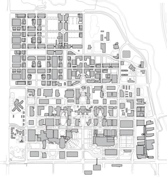
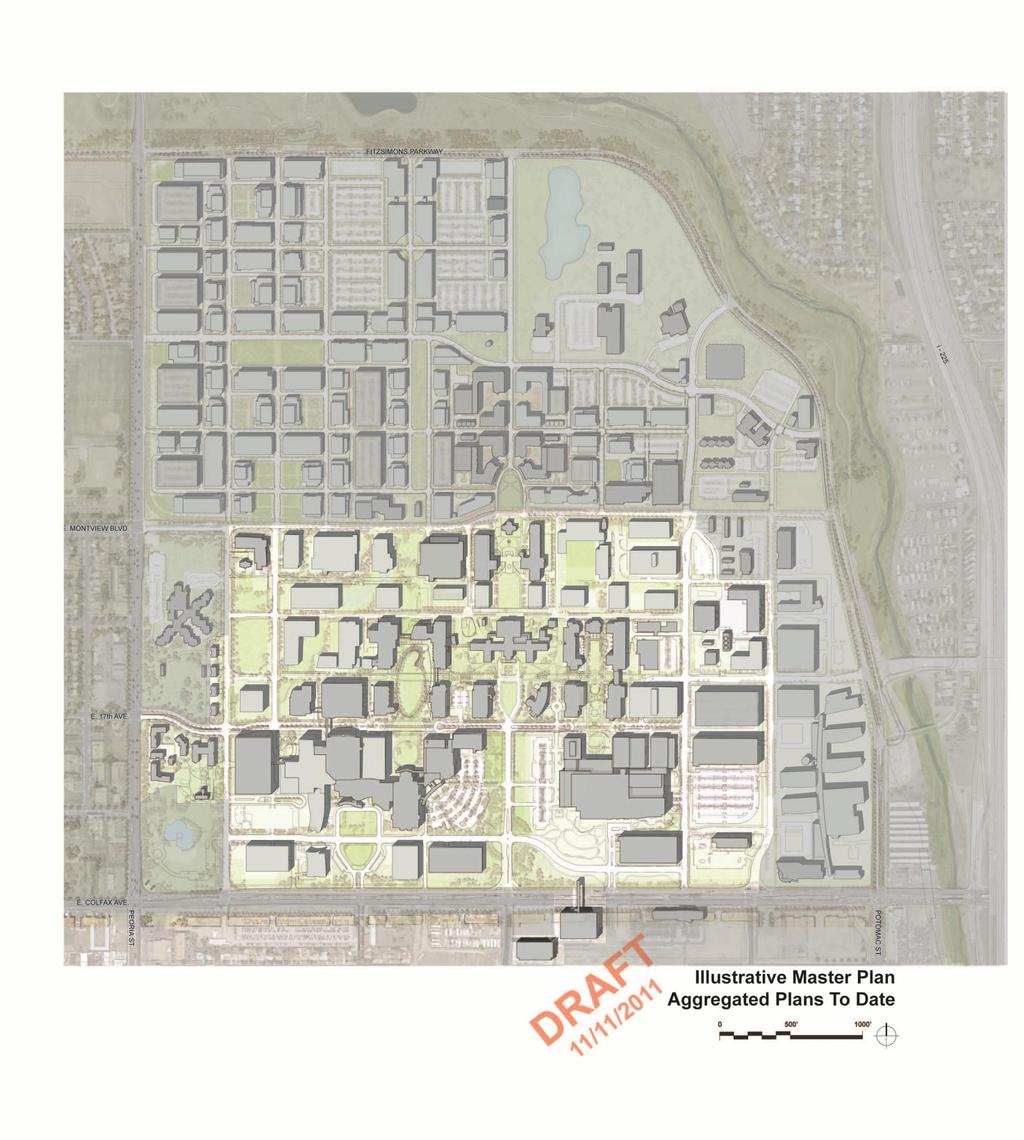
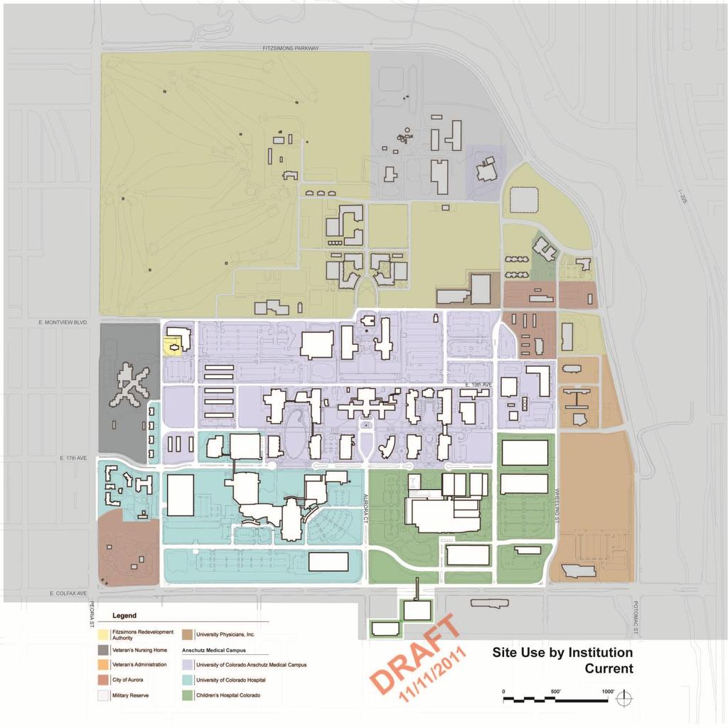
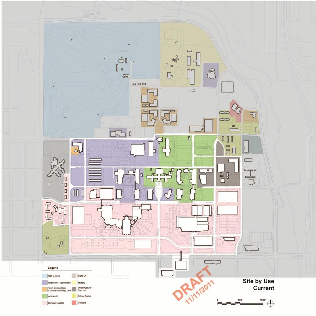
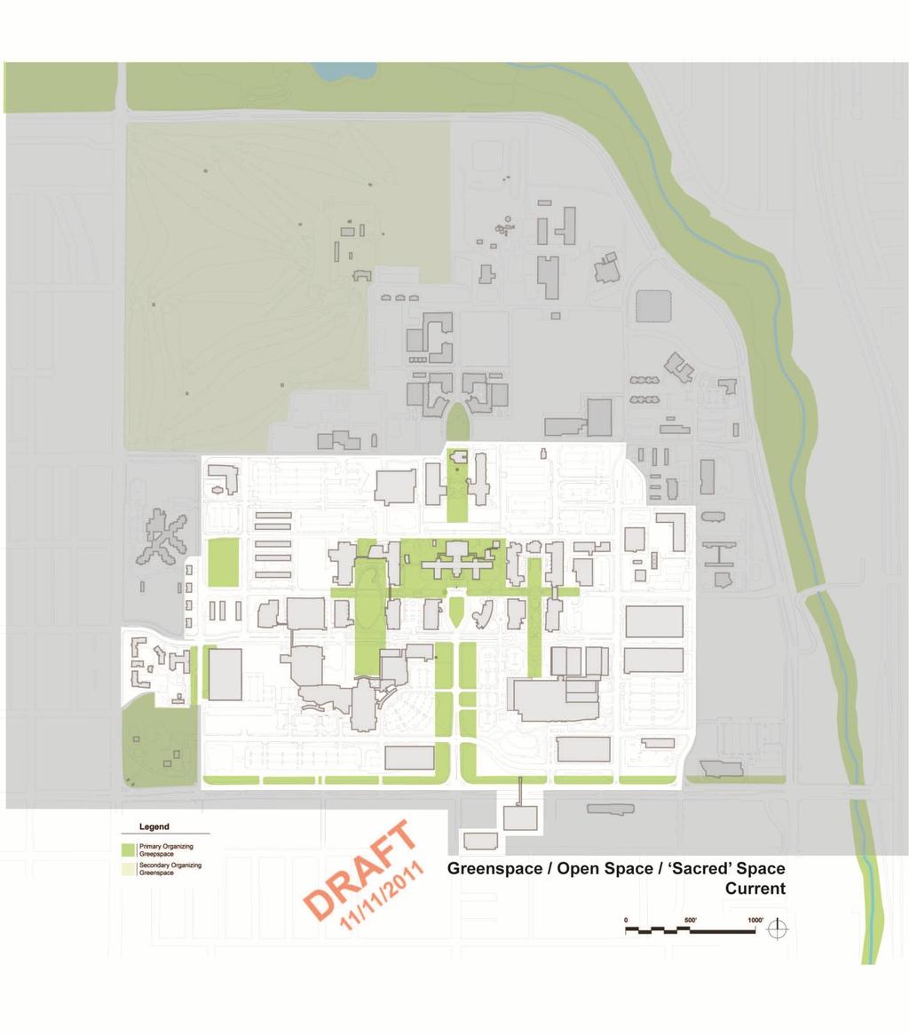
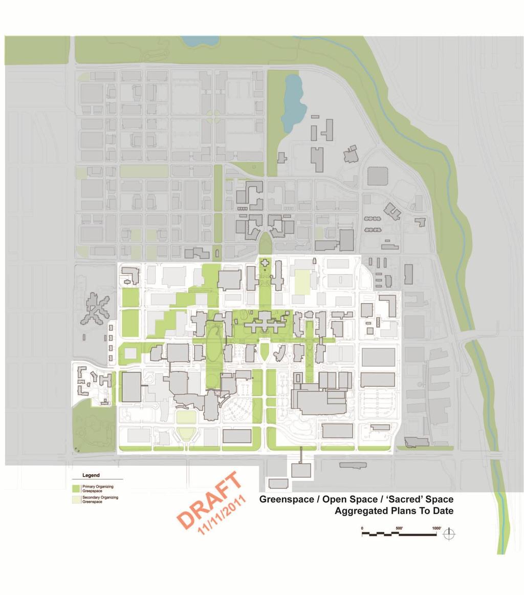
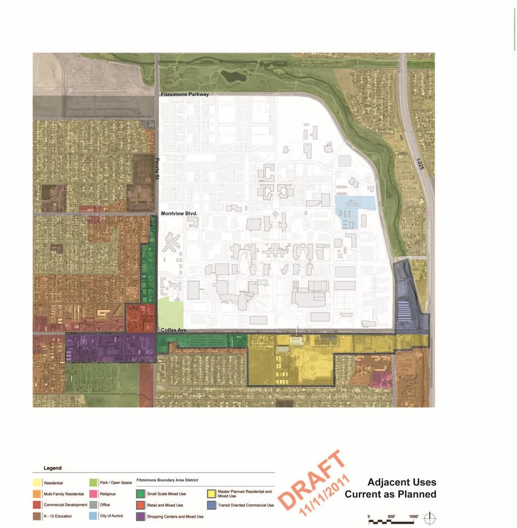
10 Health Sciences City The available land area, although limited, combined with the unique partnership between the primary institutions and the supporting partnerships of the development interests within the adjacent Bioscience Park and the City of Aurora, has presented the opportunity to create an integrated clinical, academic, research and professional community. To support the idea of Health Sciences City, a town center environment with a variety of commercial and residential uses was established at the heart of the site focusing on the existing historic Red Cross building and nearby post chapel, and extending to the historic Building 500, the former FAMC hospital, now an administrative center. Planning Guidelines Campus planning, landscape and architectural guidelines allow development to occur in a unified and ordered manner without sacrificing the opportunity for diversity in the buildings or exterior spaces. The architecture of the campus is largely organized to form strong, coherent edges to functional open spaces and streets - buildings are positioned, not as individual elements, but as elements that form a series of edges that reinforce the organization of open space and circulation. The philosophy of the Master Plan is based on the positioning of potential building sites around defined open spaces and inter-related pedestrian and vehicular corridors. A physical master plan created in 1998, has served to guide the development of the campus by providing a development framework within which to grasp the programmatic opportunities and potential of a new campus. Planning Process The framework of the master plan provides an ongoing structure of circulation for pedestrians, transit, and vehicular access and service to guide the campus development. These elements are contained within a framework of open spaces and circulation routes that define, and give access to, the major development areas. Individual projects apply the principles of planning and physical development to their specific site and the surrounding sites, both existing and future, to create a micromasterplan that ensures the optimum development pattern in the continuing evolution of a campus complex that reflects those fundamental guiding principles. Physical Development Individual projects ultimately determine the way the campus operates and develops and are of the utmost importance. Key considerations include: Building for the future Flexibility of Use Expandability and Adaptability Building to appropriate density appropriate to the idea that the available land is a finite quantity and that our development opportunities must be carefully preserved Economy of construction and operation and the incorporation of sustainable design principles to reduce short term impacts and long term costs Design that supports the idea of an inviting and welcoming campus environment, with sheltered, transparent building entrances and circulation spaces configurations that present a welcoming identity for the environment at nighttime and during the day. Creating and maintaining future opportunities for connectivity with pedestrian routes, shuttle circulators and bridges. Connections between buildings and functions are critical to the concept of campus integration, interdisciplinary work, and shared resources. These connections can take on a variety of forms from underground tunnels, open walkways at grade level, bridges, enclosed building sections, or a combination of these. In some cases, these connections may occur through buildings or structures. Developing working, learning and patient spaces to take advantage of natural light and views wherever possible, reducing lighting loads and contributing to individual orientation and comfort. Creating within the open space framework and architecture, variety in expression and character appropriate to individual uses - healing and restful environments, areas for collaboration and contemplation, as well as ceremonial spaces and places for gatherings and active play. Developing exterior spaces to accommodate an active, healthful lifestyle appropriate to a health sciences campus with areas of informal recreation, jogging and walking trails, bike and pedestrian routes. Minimizing the impact of the development on the natural environment by reducing and controlling storm runoff, maintaining efficient lighting levels and reducing light pollution, reducing vehicular traffic, and in general, designing structures and landscapes responsive to the unique nature of the Colorado environment. To ensure consistent development reflecting the highest quality in planning and design, the University Design Review Board conducts periodic reviews of projects being developed on the Anschutz Medical Campus. Similar development reviews occur within the surrounding development areas.
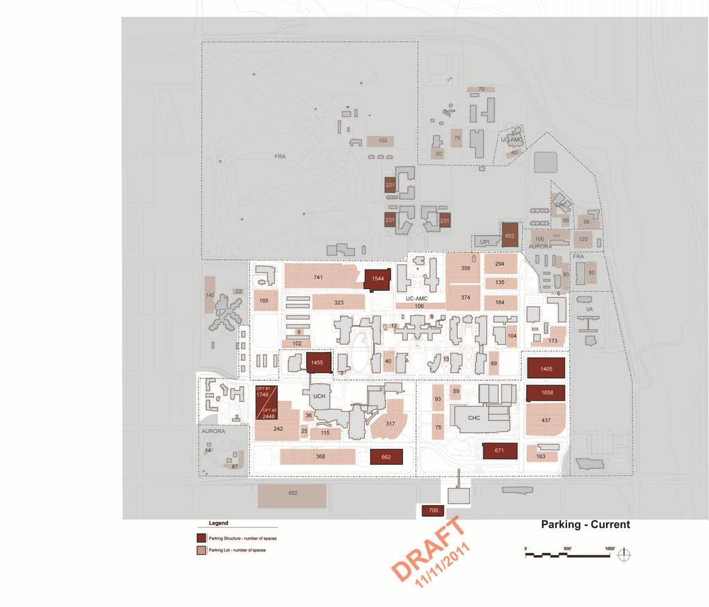
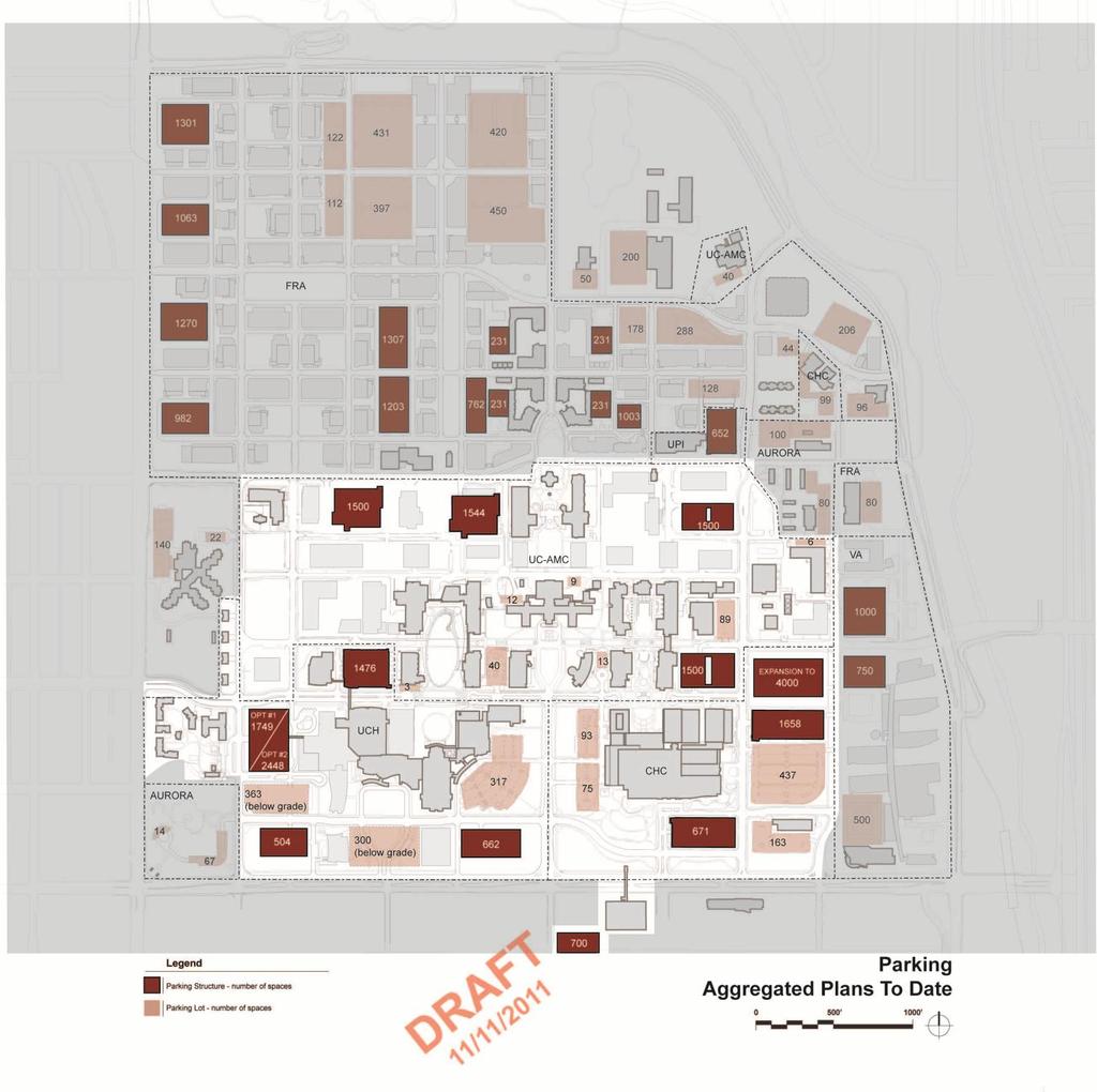
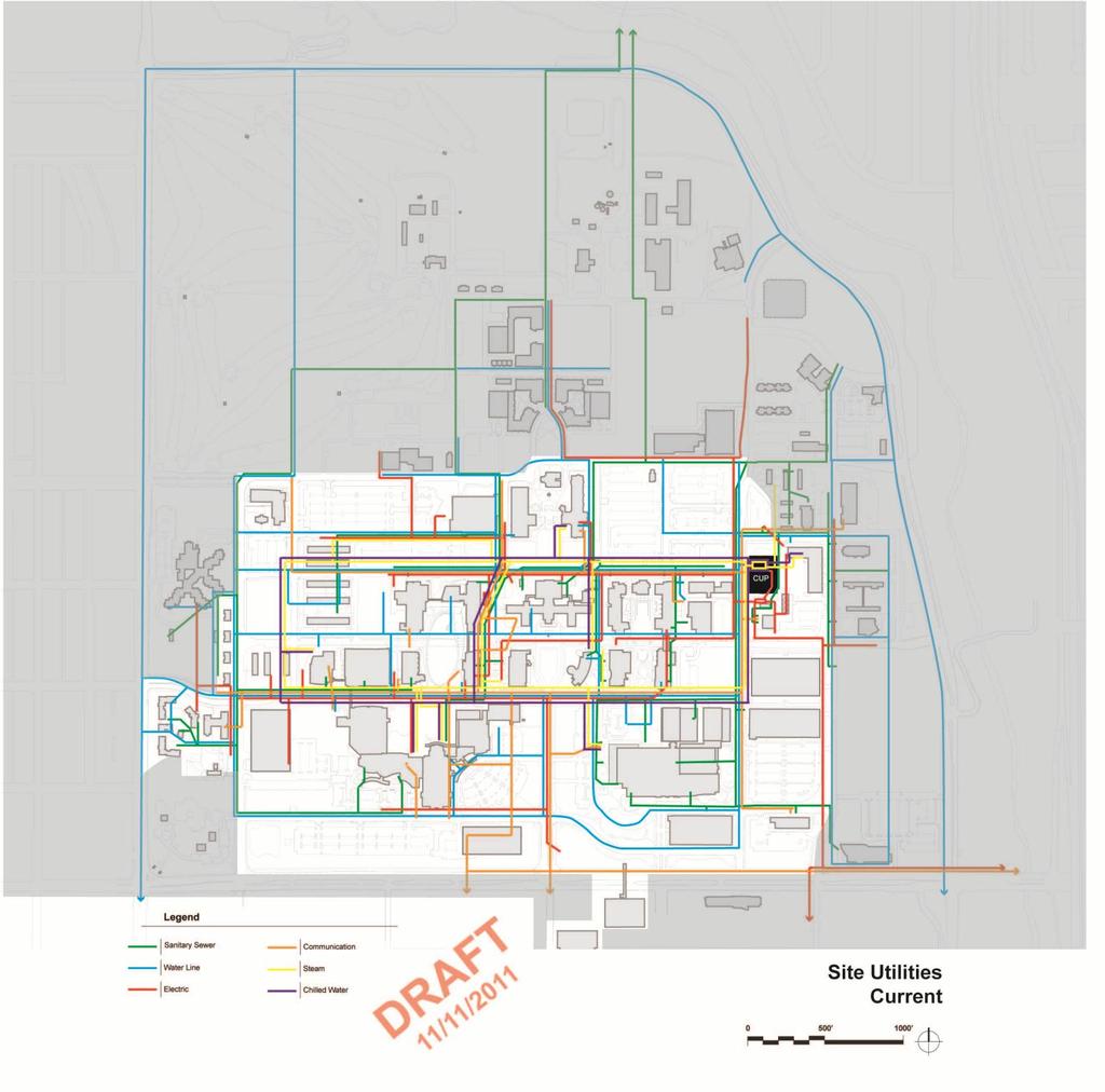
11 Planning and Design Principles The development framework and guidelines for planning and design reflect those over-arching principles and inform daily, short-term decisions with a long-range perspective. Create a Patient/Visitor friendly- welcoming and approachable campus. Provide connections to community amenities and resources, such as the adjacent Respect the landscape legacy of the site the concept of buildings in a park. open space of Sand Creek, as natural extensions of the open space of the campus. Respect the fact that the land is a finite resource use it efficiently. Promote interaction between the campus community and the surrounding Create a campus where buildings achieve a unified image beyond individual public/private communities. function. Incorporate a common palette of materials and elements of design that Build a system of efficient roadways including a ring road near the perimeter to are appropriate to Colorado and our unique climate. augment the system of surrounding arterial streets and highways minimize Maintain symbolic historic gateway from Colfax Avenue to Building 500. interior roadways to allow an efficient, connected, pedestrian core. Enhance image and identity of campus edge with a pattern of landscape elements Provide multiple points of vehicular entry to the campus to increase accessibility and features that create a memorable campus identity. for patients, faculty, staff, students and visitors, thereby reducing congestion and Provide flexibility for new opportunities; allow for building expansion and logical better accommodating the volume and variety of traffic generated by the academic new building sites. health center. Provide a land bank for future development opportunities and growth. Develop a multi-modal landscape and transit corridor along Montview Boulevard Create utility corridors that underlie major pedestrian and vehicular routes to that acts as a seam between the academic health sciences campus and the serve all areas of the campus. neighboring Bioscience Park. Program needs drive the physical development create a flexible, responsive Develop pathways and service connections linking the RTD light rail and bus development framework. transit stations to the activities of the campus. Define overall campus zones for research, education and clinical facilities that Utilize a system of perimeter parking structures and facilities to provide for an overlap to promote interdisciplinary development and activities, and sharing of efficient mode transition for visitors, patients, and employees. resources. Provide parking facilities near arrival points and treatment centers within the Create and preserve open spaces that give identity to campus zones. clinical zone. Primary open spaces within the campus include the research and clinical commons, Encourage combined use of parking facilities to increase efficiency. the education (Boettcher) commons, the informal open space connecting General s Integrate appropriate alternative and supplemental uses within parking structures to Park and the historic post chapel, the commons connecting the Red Cross building increase efficiency and convenience. and Building 500, and the historic parade grounds. Utilize land for designated for future development as surface parking areas to Create a network of open spaces that create opportunities for interaction between reduce initial development costs. faculty, students, and staff. Encourage the development of parking below grade and below buildings to use land Connect buildings and institutions with common open spaces that facilitate more efficiently. pedestrian and alternative mode movements. Integrate transit and other alternative modes of travel and access that reduce the use The research and clinical commons link the UCH and Anschutz Medical Center of single occupancy vehicles. with the teaching and research complex of the UC Denver. The educational Ensure that bike routes and pedestrian pathways are integrated with patterns in the (Boettcher) commons link the CHC with the teaching and clinical areas of the surrounding community. education zone. And, the commons north of Building 500 link the academic and Develop in a logical sequence. administrative areas with the town center. Enhance movement within the campus through the network of open spaces with views connecting architectural and landscape landmarks that provide orientation and facilitate wayfinding.
12
13
14
15
16
17
18
19
20
21
22
23
24
25
26
27
28
29
30
31
32
33
34
35
36
37
38
39
iii. Visioning framework
 III. VISION iii. Visioning framework III.1 Overview A vision is a clear and succinct description of what an institution and its community should look like after it successfully implements its goals and
CAMPUS MASTER PLAN UPDATE Transportation Element Focus Group Meeting #3
 CAMPUS MASTER PLAN UPDATE 2010-2020 Transportation Element Focus Group Meeting #3 December 2012 5 03 December 2012 1 Campus Master Plan 2010-2020 : Transportation Agenda 1. MMC 2. EC a. Inventory & Analysis
This is the East Carolina University Comprehensive Facilities Master Plan Final Draft Plan Review. This workbook reviews the campus draft master plan
 This is the East Carolina University Comprehensive Facilities Master Plan Final Draft Plan Review. This workbook reviews the campus draft master plan first presented on campus on June 29 and June 30, 2011.
New-Cast Mixed-use Development Proposal King Street West, Newcastle, Ontario
 URBAN DESIGN BRIEF New-Cast Mixed-use Development Proposal King Street West, Newcastle, Ontario TABLE OF CONTENTS: 1.0 Executive Summary 2.0 Creating Vibrant and Sustainable Urban Places: Excerpts from
CAL POLY MASTER PLAN UPDATE, March 2015
 Some Key Themes in the General Guiding Principles Academic Mission The plan must foremost advance the University s academic mission and student success. Foresight and Adaptability The plan should take
The University District envisions, in its neighborhood
 Envisioning the University District Link Light Rail in Seattle s neighborhoods CIY OF SEALE CONCEP-LEVEL SAION AREA PLANNING RECOMMENDAION RESOLUION # 30165 EXHIBI L Vision 08.2000 he University District
Neighborhood Districts
 NEIGHBORHOOD DISTRICTS SEVEN MAIN DISTRICTS Neighborhood Districts While the Development Plan provides a broad-scale overview of the neighborhood, this section focuses on uses and relationships at the
U n i v e r s i t y o f S o u t h C a r o l i n a A i k e n. Land Plan Study
 U n i v e r s i t y o f S o u t h a r o l i n a A i k e n Land Plan Study 06.27.2008 Goals ampus Growth Develop a Land Plan that allows for the orderly expansion of the campus over the next ten years and
University of Minnesota. MINNEAPOLIS CAMPUS DEVELOPMENT FRAMEWORK February 11, 2016
 MINNEAPOLIS CAMPUS DEVELOPMENT FRAMEWORK DEVELOPMENT FRAMEWORK of use shape the campus today and may inform the future. Form, meaning how the shape, size, orientation, and arrangement of buildings, spaces,
CHAPTER 7: Transportation, Mobility and Circulation
 AGLE AREA COMMUNITY Plan CHAPTER 7 CHAPTER 7: Transportation, Mobility and Circulation Transportation, Mobility and Circulation The purpose of the Transportation, Mobility and Circulation Chapter is to
UCSF Parnassus Heights Re-Envisioning Process
 UCSF Parnassus Heights Re-Envisioning Process Community Working Group Meeting #5 February 27, 2019 Agenda Welcome, Introductions, Agenda Overview, and Review of Last Meeting Summary of Community Ideas
University of the District of Columbia Van Ness Campus Master Plan Community Open House 3. December 8, 2010
 University of the District of Columbia Van Ness Campus Master Plan Open House 3 December 8, 2010 Introductions Sequence of Work: Campus Master Plan BEGIN: INTRODUCE AND START WORK Project Initiation Team
C. Westerly Creek Village & The Montview Corridor
 C. Westerly Creek Village & The VISION Community Vision When the goals of the city are achieved Westerly Creek Village, a distinctive community defined by Montview Boulevard and Westerly Creek, is a strong
Phase 1 : Understanding the Campus Context. Phase 2 : APPROACHES - Alternates & Preferred Plan
 Introduction MASTER PLAN PURPOSE WHY A CAMPUS MASTER PLAN? The purpose of the Master Plan at the University of Illinois at Chicago is to translate UIC s strategic goals and objectives into a compelling
38 Queen s University Campus Master Plan Part 1
 38 Queen s University Campus Master Plan Part 1 46 The Campus at the City Scale Chapter 4 The Campus at the City Scale 39 Queen s is an urban University centrally located in Kingston. Decisions made by
Public input has been an important part of the plan development process.
 Lakewood s Comprehensive Plan recognizes that transportation helps shape the community, and that the way the community provides for the safe and efficient movement of people affects the character of the
Figure 3-1: Public Realm Plan
 3 Public Realm Figure 3-1: Public Realm Plan 3.1 Public Realm Concept The public realm concept for the Little Mountain site integrates a clear and accessible movement network with public spaces for social
Welcome. Community Consultation Meeting November 28, Review and discuss the Bathurst Quay Neighbourhood Plan Framework
 Welcome Community Consultation Meeting November 28, 2016 Why Are We Here Today? Review and discuss the Bathurst Quay Neighbourhood Plan Framework Review and discuss an Action Plan for Implementation Next
Preci nct P l ans Figure 56 Campus Aerial Photo, 2008 CAL STATE EAST BAY, HAYWARD CAMPUS MASTER PLAN
 9 Precinct Plans This section contains a detailed discussion of the planning and design concepts for specific areas or precincts of the Cal State East Bay Hayward campus. The Precinct Plans pertain to
PUBLIC RIGHT-OF-WAY IN THIS CHAPTER PUBLIC REALM
 PUBLIC RIGHT-OF-WAY This section provides design guidelines for improvements in the public right-of-way. The public right-of-way refers to streets, sidewalks, non-vehicular thoroughfares, parks and greenways
Existing Conditions. Planning and Design Principles
 penn s south bank enn s South Bank is located south of the Schuylkill River at the intersection of 4th Street and. This acre former heavy industrial site offers the opportunity to accommodate a variety
THE 355/270 CORRIDOR:
 THE 355/270 CORRIDOR: Strategic Ideas for Sustaining a Livable Work Place Project Summary ACCESS LIFE DESIGN HEALTH WORK Montgomery County Planning Department The Maryland-National Capital Park and Planning
12 February CAMPUS MASTER PLAN UPDATE Focus Group - Wayfinding & Signage
 12 February 2016 CAMPUS MASTER PLAN UPDATE Focus Group - Wayfinding & Signage AGENDA Introductions Planning Scope The 2004 Campus Plan Observations SWOT Exercise Analysis Goals and Advice Questions & Discussion
LOS ANGELES MISSION COLLEGE MASTER PLAN Master Plan DESIGN & DEVELOPMENT PRINCIPLES
 LOS ANGELES MISSION COLLEGE MASTER PLAN DESIGN & DEVELOPMENT PRINCIPLES 34 Quality Learning Along the Arroyo PROGRAM SUMMARY BY PROJECT The following are program summaries for each of the projects planned
V. Gateways GATEWAYS / V-1
 V. GATEWAYS / V-1 Many of Chesapeake s gateways are located on highways and call for bold and attractive designs that motorists can understand, appreciate, and enjoy. can also take the form of natural
St. Louis Park Wooddale LRT Station Site development guidelines
 St. Louis Park Wooddale LRT Station Site development guidelines November 2013 OVERVIEW St. Louis Park s convenient location as a neighbor to Minneapolis means you re only minutes away from some of the
4- PA - LD - LIVELY DOWNTOWN. LD - Background
 4- PA - LD - LIVELY DOWNTOWN LD - Background The downtown has been the service centre for the community since the city s inception and the area continues to supply people with their personal services,
Table of Contents. Elm Avenue Improvement Plan City of Waco, Texas. Introduction 1. Existing Context 1 Figure 1 2.
 Table of Contents Introduction 1 Existing Context 1 Figure 1 2 Plan Guidelines 3 Future Urban Form 4 The West-End 4 Main Street 6 The East-End 7 Figure 2 9 Public Improvement Recommendations 7 General
Sheridan Boulevard S TAT I O N A R E A P L A N S H E R I D A N B O U L E VA R D S TAT I O N A R E A P L A N
 Sheridan Boulevard S TAT I O N A R E A P L A N 1 City of Lakewood Adopted November, 2006 S H E R I D A N B O U L E VA R D S TAT I O N A R E A P L A N The Vision The City of Lakewood s overall vision is
CAMPUS MASTER PLAN UPDATE
 13 April 2016 CAMPUS MASTER PLAN UPDATE Focus Group Landscape AGENDA What We Heard Review of Campus Observations & Analysis Campus Framework & Open Space Network Table-Top Exercise Landscape Guideline
THE LANDMARK PROJECT: ST. GEORGE CAMPUS BEFORE AND AFTER
 THE LANDMARK PROJECT: ST. GEORGE CAMPUS BEFORE AND AFTER The Landmark Project will reimagine the historic core of the St. George campus by creating dynamic, open spaces where students, faculty and the
264 neighborhoods NEIGHBORHOOD 6: WOODLAWN AND TENTH STREET
 NEIGHBORHOOD 6: WOODLAWN AND TENTH STREET Existing Aerial View Looking North EXISTING CHARACTER The area north of East Tenth Street and south of the railroad tracks has been identified for significant
11 February CAMPUS MASTER PLAN UPDATE Focus Group - Design Guidelines
 11 February 2016 CAMPUS MASTER PLAN UPDATE Focus Group - Design Guidelines AGENDA Introductions Planning Scope The 2004 Campus Plan Observations Design Guidelines - 2004 Plan SWOT Exercise Analysis Goals
K. SMART ASSOCIATES LIMITED
 Planning Justification Report Zoning By-Law Amendment 185 King Street North Waterloo, Ontario April 7th, 2017 Project Reference Number 16-245 K. SMART ASSOCIATES LIMITED CONSULTING ENGINEERS AND PLANNERS
01 the vision NEW LYNN IS WAITING FOR THE GREAT LEAP FORWARD
 [A] FRAMEWORK 01 the vision 02 the framework 03 urban design principles 04 c o n t e x t 05 issues a n d o p p o r t u n i t i e s 06 creating a t.o.d. 07 key recommendations 08 seven strategic areas of
EXISTING COMPREHENSIVE PLAN
 EXISTING COMPREHENSIVE PLAN Town Center Land Use Element: V. LAND USE POLICIES Town Center Mercer Island's business district vision as described in "Your Mercer Island Citizen-Designed Downtown" was an
Silverdale Regional Center
 Silverdale Regional Center Vision for Silverdale Regional Center The Silverdale Regional Center Plan (Plan) will guide the evolution of the Silverdale Regional Center from a collection of strip malls and
Transportation. Strategies for Action
 Transportation A major priority for the Overlake Neighborhood is to develop a multimodal transportation system. To achieve this system, a balance has to be found among travel, circulation and access needs;
Subcampus Recommendations
 T he campus is is comprised of three major areas. These subcampus areas are known as WestCampus, South Campus, Campus Oakland and Drive East Campus. and Future East growth Campus. requires a Future careful
Policies and Code Intent Sections Related to Town Center
 Policies and Code Intent Sections Related to Town Center The Town Center Vision is scattered throughout the Comprehensive Plan, development code and the 1994 Town Center Plan. What follows are sections
Town Center (part of the Comprehensive Plan)
") Town Center (part of the Comprehensive Plan) Mercer Island Town Center Looking North (2014) In 1994, a year-long process culminated in a set of design guidelines and code requirements for the Town Center
Town Center (part of the Comprehensive Plan) Mercer Island Town Center Looking North (2014) In 1994, a year-long process culminated in a set of design guidelines and code requirements for the Town Center
Academics Efficient use of space will be used to enhance investments in new pedagogies such as active learning classrooms.
 Goals and Assumptions Physical Planning Goals and Objectives The guiding principles of this Master Plan were developed in consultation with various constituencies that make up the NMSU community and were
The Vision. Photo provided by The Minervini Group. 46 Vision, Objectives & Strategies
 Vision, Objectives & Strategies The is the public framework and guide for future development of the Grand Traverse Commons. The establishes public polices for infrastructure, the preservation of natural
Table L-1 Summary Action Strategy. Action Item Timing Status Responsible Agency
 CHAPTER 4: CIRCULATION ELEMENT ISSUE #1: MAJOR THOROUFARES AND TRANSPORTATION ROUTES A balanced transportation system for Fontana is provided that meets the mobility needs of current and future residents
Complete Neighbourhood Guidelines Review Tool
 Complete Neighbourhood Guidelines Review Tool Prepared By: City of Regina Planning Department October 2014 Page 1 of 14 Community Development Review Checklist for Secondary Plans and Concept Plans The
10 February CAMPUS MASTER PLAN UPDATE Focus Group - Landscape & Hensel Park
 10 February 2016 CAMPUS MASTER PLAN UPDATE Focus Group - Landscape & Hensel Park AGENDA Introductions Planning Scope The 2004 Campus Plan & Survey Observations 2004 Landscape Plan SWOT Exercise Analysis
hermitage town center
 hermitage town center A Community Vision prepared by Strada for The City of Hermitage and The Mercer County Regional Planning Commission January 2007 table of contents introduction 3 design principles
Corridor Vision. 1Pursue Minnehaha-Hiawatha Community Works Project. Mission of Hennepin County Community Works Program
 1Pursue Minnehaha-Hiawatha Community Works Project Minnehaha-Hiawatha Community Works is a project within the Hennepin Community Works (HCW) program. The mission of the HCW program is to enhance how the
Guiding Principles for the SR 520 Replacement Project
 Guiding Principles for the SR 520 Replacement Project Presentation to the Board of Regents Theresa Doherty Assistant Vice President for Regional Affairs May 18, 2006 F-14 The University of Washington is
Garden edges provide vertical plantings to buffer the neighbors from the building facilities around the entire campus.
 Open Space Existing Open Space Children s intends to maintain the landscape as a garden around the campus to help children heal while providing spaces for visitors, caregivers, staff and neighbors. Children
NEIGHBORHOOD 3: UNIVERSITY EDGE
 NEIGHBORHOOD 3: UNIVERSITY EDGE Aerial View of North Indiana Avenue EXISTING CHARACTER The University Edge neighborhood represents the primary town/gown interface between the campus and the city of Bloomington,
EXISTING CONDITIONS 41. Existing Conditions
 EXISTING CONDITIONS 41 Existing Conditions The Existing Analysis phase of the planning process involved a study of the existing conditions on the campus in order to identify key planning issues to be addressed
This Review Is Divided Into Two Phases:
 Semiahmoo Town Centre Review The purpose of this review: To review the Semiahmoo Town Centre Concept Plan, originally approved in 1993, to ensure that this centre will continue to serve the needs of South
The University of Vermont #AMPUSª-ASTERª0LAN. & Design Guidelines. May 2006
 The University of Vermont #AMPUSª-ASTERª0LAN & Design Guidelines May 2006 The University of Vermont Campus Master Plan & Design guidelines May 2006 The University of Vermont Campus Master Plan & Design
18 May 2016 CAMPUS MASTER PLAN UPATE
 18 May 2016 CAMPUS MASTER PLAN UPATE Council of the Deans ( Over view) AGENDA Engagement & What We Heard Focus Elements: 1. Development Framework Plan 2. Campus Mobility 3. Campus Guidelines 4. Wayfinding
A Vibrant Downtown. Chapter 5 Cary Public Art Opportunities 31
 A Vibrant Downtown Cary s vision for Downtown is a unique, vibrant, dynamic, pedestrian friendly location; a regional destination and a place to live, work, and recreate, according to the 2001 Town Center
CONNECTING CAMPUS AND COMMUNITY
 CONNECTING CAMPUS AND COMMUNITY Comprehensive Transportation Planning at OSU 2016 Central Ohio Planning and Zoning Workshop // May 20 th Beth Snoke, Director, Transportation and Traffic Management // The
8.0 Built Form Framework
 Figure C-40. RIC and Laboratory Building Internal Pedestrian Node 8.0 Built Form Framework The built form framework defines the desired future character and function of built elements within the campus
Metro. Activity Center Design Guidelines. Recommendations For Developing Focused, Mixed-Use Commercial/Residential Centers
 Metro Activity Center Design Guidelines Recommendations For Developing Focused, Mixed-Use Commercial/Residential Centers Metro Activity Centers What is a MAC? Legacy, the adopted guide for the future growth
ANC 2A Presentation. November 9, 2006
 ANC 2A Presentation November 9, 2006 Introduction & Overview Applicants Boston Properties and KSI Services (project developers) The George Washington University (land owner) 2.66 acre site (former GW hospital
Small Area Plan. South Gateway
 Small Area Plan Adopted May 12, 2008 South Gateway Purpose. The South Gateway Small Area Plan defines the City s expectations for the future of the southern entrance to the City at Interstate 85 and Highway
ELK GROVE GENERAL PLAN VISION
 2-1 CHAPTER 2: 2-2 CREATING OUR The Community Vision for Elk Grove, expressed through a Vision Statement and a series of Supporting Principles, is a declaration of the kind of community that Elk Grove
University of Pennsylvania, Neural and Behavioral Sciences Building
 University of Pennsylvania, Neural and Behavioral Sciences Building Philadelphia, Pennsylvania Category: Architecture The genesis for the new Neural and Behavioral Sciences (NBS) building is the acknowledgment
City of Heath. Town Center Concept
 In the give-and-take of getting projects designed, financed, and approved, the famous refrain from the film Field of Dreams is heard often: if you build it, they will come. From the perspective of the
NEIGHBORHOOD 7: FEE LANE AREA. Aerial View of Briscoe and McNutt Dormitories
 NEIGHBORHOOD 7: FEE LANE AREA Aerial View of Briscoe and McNutt Dormitories Fee Lane Area Map Briscoe Dormitory 278 neighborhoods NEIGHBORHOOD 7: FEE LANE AREA EXISTING CHARACTER The Fee Lane Area neighborhood
University of Saskatchewan CAMPUS MASTER PLAN. Senate Meeting Preliminary Presentation. April 21, 2018 DIALOG ECS DA WATT
 University of Saskatchewan CAMPUS MASTER PLAN Senate Meeting Preliminary Presentation April 21, 2018 DIALOG ECS DA WATT project process presentation agenda Stakeholder Engagement Project Control phase1
Plan Framework Report. Attachment A
 Plan Framework Report Attachment A Uptown-Douglas Corridor Plan - Plan Framework Report Contents Introduction... 1 Planning Process... 3 Project Objectives... 4 Vision... 5 Community Values... 6 Structural
Ivywild On The Creek PRELIMINARY CREEK DISTRICT MASTER PLAN
 Ivywild On The Creek PRELIMINARY CREEK DISTRICT MASTER PLAN Introduction: Rejuvenating an extraordinary Creekside neighborhood THE CREEKSIDE DISTRICT The Ivywild On The Creek Neighborhood District Master
Wadsworth Boulevard S TAT I O N A R E A P L A N
 Wadsworth Boulevard S TAT I O N A R E A P L A N City of Lakewood Adopted November, 2006 The Vision The City of Lakewood s overall vision is to transform the area around the light rail station into a mixed-use
Queensborough Eastern Neighbourhood Node. Community Open House
 Queensborough Eastern Community Open House The Vision The Queensborough Eastern will become the heart of eastern Queensborough. Through a sensitive mix of viable commercial and residential areas, the neighbourhood
11.0 TRANSPORTATION ELEMENT
 11.0 TRANSPORTATION ELEMENT Transit, Circulation and Parking Sub-Element: For all campuses, FIU's goal is to increase multimodal access. In combination with other measures - such as the development of
CHARLES PUTMAN CHARLES PUTMAN AND ASSOCIATES, INC
 MEMORANDUM CHARLES PUTMAN & ASSOCIATES, INC. LAND DEVELOPMENT CONSULTANTS PLANNING ZONING PERMITTING 4722 NW Boca Raton Boulevard, Suite C-106 Boca Raton, Florida 33431 Phone: 561/994-6411 FAX: 561/994-0447
Colchester Northern Gateway Master Plan Vision Review Draft. July 2016
 Colchester Northern Gateway Master Plan Vision Review Draft July 2016 Contents Introduction 4 Context 8 Purpose of the Report 8 Strategic Position 9 Overview of the Process 11 2012 Master Plan Vision 12
The following principles guide the development of goals and strategies to protect and promote these amenities:
 OPEN SPACE/PARKS/TRAILS/RECREATION GOALS/STRATEGIES Cherry Hills Village is a living environment that offers low density development, open areas, public scenic vistas, public trails and public parks. This
Courthouse Square Planning & Urban Design Study. Courthouse Square Working Group #13 October 15, 2014
 Courthouse Square Planning & Urban Design Study Courthouse Square Working Group #13 October 15, 2014 1 Courthouse Square Process Working Group Community Courthouse Square Advisory Groups & Civic Associations
The transportation system in a community is an
 7 TRANSPORTATION The transportation system in a community is an important factor contributing to the quality of life of the residents. Without a sound transportation system to bring both goods and patrons
CAMPUS MASTER PLAN UPATE
 19 MAY 2016 CAMPUS MASTER PLAN UPATE Metropolitan Planning Organization AGENDA Introductions Planning Scope Observation & Analysis: Mobility Systems Campus Development Plan Mobility Planning Scenarios
URBAN DESIGN BRIEF. 2136&2148 Trafalgar Road. Town of Oakville
 URBAN DESIGN BRIEF 2136&2148 Trafalgar Road Town of Oakville Prepared By: METROPOLITAN CONSULTING INC For 2500674 Ontario Inc November 2016 TABLE OF CONTENTS Page No. 1.0 Introduction/Description of Subject
Developer s Program. The Station at East 54
 Developer s Program The Station at East 54 Existing Conditions The Station at East 54 is proposed for a 1.12 acre site at the northeast corner of Hamilton Road and Prestwick Road, tucked between the East
DRAFT ROOSEVELT ROAD. District Recommendations. Figure 5.23 The Roosevelt Road Corridor
 CHAPTER 5 Figure 5.23 The Road Corridor Road will develop as a mixed-use corridor, emphasizing regional retail, west of the river and mixed-use development east of the river. KEY RECOMMENDATIONS 1. High
GUIDELINES EXHIBITION PLACE LOCATION: OBJECTIVES. Structure Plan URBAN DESIGN GUIDELINES
 Development in the Exhibition Place lands will be consistent with the following urban design guidelines. They provide a framework for new development of the lands and are to be read in conjunction with
Hockessin Community Redevelopment Plan
 Hockessin Community Redevelopment Plan 3.1 Introduction The Community Redevelopment Plan for the Village of Hockessin is the result of the people s vision for a distinct village center that serves as the
1 Welcome! UBC Okanagan Master Plan Update - Open House
 1 Welcome! UBC Okanagan Master Plan Update - Open House UBC is updating the Master Plan for the Okanagan Campus. The purpose of today s Open House is to: Present the draft 2015 Master Plan Answer any questions
4. INDUSTRIAL 53 CASTLE ROCK DESIGN
 4. INDUSTRIAL 53 CASTLE ROCK DESIGN CASTLE ROCK DESIGN 54 4. INDUSTRIAL Overview Well-designed and attractive industrial centers are the product of blending economic realities with both functional and
01 Welcome! About Ontario Shores
 01 Welcome! Thank you for participating in the Master Planning Open House. Ontario Shores Centre for Mental Health Sciences is in the process of preparing a Master Program and Master Plan for submission
PROJECT NARRATIVE STATEMENT OF JUSTIFICATION. Special Use Permit Modification Application
 PROJECT NARRATIVE AND STATEMENT OF JUSTIFICATION Special Use Permit Modification Application For: Facility Expansion 1602 East Franklin Street Chapel Hill, NC PIN #9799-14-1643 Applicant: SHC Construction
2.0 THE PLATINUM TRIANGLE VISION
 2.0 THE PLATINUM TRIANGLE VISION The envisions an exciting future for the area surrounding Angel Stadium of Anaheim, the Honda Center and The Grove of Anaheim. 2.1 Planning Principles In order to further
SECTION TWO: Urban Design Concepts
 SECTION TWO: Urban Design Concepts The Gardnerville Plan for Prosperity shapes economic opportunities presented by regional growth. The Urban Design Concepts provide policies and concepts for land use,
V. Vision and Guiding Principles
 V. Vision and Guiding Principles The Master Plan for the Powers Ferry Corridor seeks a foundation in the desires of the community. At times, various elements of the community offered opposing viewpoints,
Regional Context Statement
 Regional Context Statement REGIONAL CONTEXT STATEMENT 3. REGIONAL CONTEXT STATEMENT In 1995, the Provincial Government passed into law the Growth Strategies Act. The purpose of this provincial initiative
City of Farmington. Downtown Plan. Amendment to the 1998 Master Plan Adopted October 11, 2004
 City of Farmington Amendment to the 1998 Master Plan Adopted October 11, 2004 Introduction Planning Background 1 Scope and Components of the Plan Amendment 2 Concept Introduction 3 Plan Concepts 3 Conceptual
Status Report: MD 355 Project
 Status Report: MD 355 Project OCTOBER 2006 M-NCPPC MONTGOMERY COUNTY PLANNING DEPARTMENT Summary of Community Comments, and break to the Results of the MD 355 Participation Session Brookside Gardens -
Albert Lea. Redevelopment Plan. 701 Xenia Avenue South, Suite 300 Minneapolis, MN Tel: (763) Fax: (763) wsbeng.
 Fax: (763) wsbeng.") Albert Lea Redevelopment Plan 701 Xenia Avenue South, Suite 300 Minneapolis, MN 55416 Tel: (763) 541-4800 Fax: (763) 541-1700 wsbeng.com Albert Lea Redevelopment Plan Table of Contents Composite Districts...
Albert Lea Redevelopment Plan 701 Xenia Avenue South, Suite 300 Minneapolis, MN 55416 Tel: (763) 541-4800 Fax: (763) 541-1700 wsbeng.com Albert Lea Redevelopment Plan Table of Contents Composite Districts...
DRAFT Land Use Chapter
 Stevens Creek Urban Village DRAFT 1 18 17 Land Use Chapter INTRODUCTION This Land Use Chapter describes how the Stevens Creek Urban Village will accommodate the growth that is planned for it in the Envision
REGIONAL ACTIVITY CENTER
 DRAFT REGIONAL ACTIVITY CENTER 70 EAST BENCH MASTER PLAN DRAFT 06 Introduction The East Bench Regional Activity center is comprised of large educational, research, medical, and employment centers. These
AIRPORT BUSINESS PARK
 PIER MAC PETROLEUM INSTALLATION LTD. AIRPORT BUSINESS PARK DEVELOPMENT APPLICATIONS March 2003 4.1 Airport Business Park Development Permit Area 4.1.1 Justification/Design Concept The design concept envisioned
Sign System Recommendations
 4.1 Sign System Recommendations 4.2 Recommended sign types required for a complete wayfinding system on the TCNJ campus are described below. Detailed sign messages and their typical locations are included
Gold Line Bus Rapid Transit Transit Oriented Development (BRTOD) Helmo Station Area Plan
 Helmo Station Area Plan") Appendix F Gold Line Bus Rapid Transit Transit Oriented Development (BRTOD) Helmo Station Area Plan Introduction and Purpose of the Plan The Gold Line Bus Rapid Transit facility is an eleven-mile dedicated
Appendix F Gold Line Bus Rapid Transit Transit Oriented Development (BRTOD) Helmo Station Area Plan Introduction and Purpose of the Plan The Gold Line Bus Rapid Transit facility is an eleven-mile dedicated
THEMES, VISION, + PRINCIPLES
 CHAPTER 2: THEMES, VISION, + PRINCIPLES This page intentionally left blank. 20 VISION DRAFT AUGUST 2018 2 2 THEMES, VISION, + GUIDING PRINCIPLES The Key Themes, Vision, and Guiding Principles presented
section five BEAUTIFICATION PLAN
 section five BEAUTIFICATION PLAN BEAUTIFICATION PLAN Section Five Beautification Plan The goal of the Beautification Plan is to improve the Route 8-Sunnyland Corridor in terms of aesthetics and to create