Place-Making Portsmouth
|
|
|
- Collin Thompson
- 5 years ago
- Views:
Transcription

1 Place-Making Portsmouth Jane Lafleur, MCRP Lift360 October 31, 2016

2 On Saturday, October 29, 2016, approximately 45 people gathered at Discover Portsmouth for an afternoon Place-Making session. Jane Lafleur, MCRP, from Liftt360 in Portland, Maine was invited to lead the discussion and hands-on workshop with community members, municipal staff and members of the Portsmouth Smart Growth organization called PS21. Lafleur is a trained City Planner and has conducted numerous workshops and trainings throughout Maine and New England. From 2003 to 2016, she was the Executive Director of Friends of Midcoast Maine, a regional smart growth and civic engagement organization. In September 2016, Lafleur joined Lift360 and works to strengthen leaders, organizations and communities through her community development consulting and coaching work. PS21 (Portsmouth Smart Growth for the 21st Century) works to present ideas and encourage discussion and policy development around planning issues in Portsmouth, N.H. Its goal is to support the creation of a vibrant, sustainable, livable, and walkable community compatible with the principles of smart growth, the historic nature of Portsmouth, and the context of the 21st century. PS21 works to involve key stakeholders, residents and the business community to establish a long-term vision for the city. PS21 interested in focusing on specific opportunity areas in Portsmouth to create active, safe and attractive places where people of all ages and abilities can have the opportunity to be physically active via recreation and transportation, particularly walking and biking. These places support and promote physical activity for ALL people, have sidewalks, safe roads for all users, multi-use paths and trails, parks and open spaces and facilities for recreation, and have quality connections between homes, stores, workplaces, schools, downtowns and/or village centers. Page 1

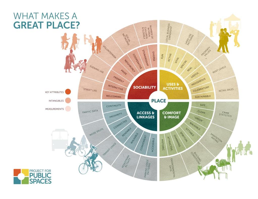
3 Place-Making and Walkability In a slide presentation to attendees, Lafleur presented the theory of Place-Making from the Project for Public Spaces (PPS) and the components of great places. She summarized the four main attributes and their intangible features as follows: Sociability: welcoming, cooperative, neighborly : fun, vital, active, special, real : connected, walkable, convenient, accessible : safe, clean, historic, charm, attractive Each attribute has methods for measuring these attributes such as property values, land use patterns, pedestrian activity, etc. Participants viewed dozens of slides from around the US that highlighted each of these factors. Page 2
4 Page 3


5 The Power of Ten The Power of Ten from the Project for Public Spaces is a tool to help community members think about a new way to evaluate and measure places. By using the goal of having ten places in their community with ten things to do at each place, communities can start building active, successful, extraordinary places that become economic engines for the community. Page 4

6 Streets and Places Lafleur also reviewed several factors to look for as we think about great places, streets and spaces, as provided by Dan Burden. These are Enclosure, Transparency, Human Scale and Complexity. Enclosure refers to the degree to which streets and other public spaces are visually defined by buildings, walls, trees and other elements. Spaces where the height of vertical elements is proportionally related to the width of the space between them have a room-like quality. Page 5

7 Transparency refers to the degree to which people can see or perceive what lies beyond the edge of a street or other public space, and more specifically, the degree to which people can see or perceive human activity beyond the edge of a street or other public space. Physical elements that influence transparency include walls, windows, doors, fences, landscaping, and openings into midblock spaces. Page 6

8 Human scale refers to the size, texture, and articulation of physical elements that match the size and proportions of humans and, equally important, correspond to the speed at which humans walk. Building details, pavement texture, street trees, and street furniture are all physical elements contributing to human scale. Page 7


9 Complexity refers to the visual richness of a place. The complexity of a place depends on the variety of the physical environment, specifically the numbers and kinds of buildings, architectural diversity and ornamentation, landscape elements, street furniture, signage, and human activity. The group also discussed the importance of gateways, crossings, connectivity, liner buildings waterfronts and wayfinding. Figure 1 Waterfront Art and Place-making, Photo courtesy of Dan Burden Page 8


10 Figure 2: Round-about, courtesy of Dan Burden Figure 3: Attractive Gateway, photo courtesy of Dan Burden Page 9


11 Place-Making Audit The group divided into four teams to conduct a place-making audit of four pre-selected locations in downtown Portsmouth. These were: Vaughan Mall Hanover & Market Streets Market Square State Street During the outdoor field work, each team visited these four pre-selected places and used the Place- Game tool to evaluate the place, first individually and then as a group. Page 10


12 Along the way to the four stops, other locations were visited for comparison and teaching moments. On the left, the affection for the alley way was clear. It was intimate, appealing, well signed, brought in good light, and the landscaping at the end of the alley softened the terminated vista of the government office building. In the photo above, people evaluated the successful parts of Portwalk Place and noticed the wide sidewalks, the street furniture, the underground utilities for street lighting, and the varying pavement textures. Moveable seating, higher tree wells for additional seating, programming activities in the space, and other pedestrian amenities would make this space even more appealing. Page 11


13 Small Group Recommendations Participants sat with different group members in order to cross-pollinate ideas. Each group discussed what they liked best about a place, what short term and long term improvements might be made, and who the partners might be to implement some of these ideas. The following captures the list of suggestions from each group. Vaughan Mall Group 1: Add off-season activities, add winter holiday market, art vendors, food trucks, sculpture, water features, mini-playground, take back a few parking spaces for activities, shipping container shops, summer concerts, wall art, shelters from the weather Improve the area between parking and walking spaces, add seating and landscaping, add a low wall We like pedestrian scale, trees, quiet, the seating, open to the sky, decent array of stores, independent and attractive stores Vary the concrete surface with texture, add lighting, especially down, dress up facades, especially northern end. Partners could be art groups, gardening groups, shop owners, adoptions! Group 2: Sociability Add children s playground Liberate the seating Christmas winter markets Good space for seasonal events Bring back the stage Make it a three season space Add food stalls, kiosks, instead of trucks Add public restrooms 21 st century corridor One way street return?? Add wayfinding to this area as a destination Sign for bike track lanes, as an alternate route Page 12
 at Bridge Street lot and whale lot Group 4 Sociability")
14 Add a water feature Coordinate the street furniture Improve the storefront look Group 3 Consider public restrooms Consider underground parking Introduce food trucks Great opportunity for pedestrian access Add more vegetative buffers, and food trucks by reducing the midblock parking lot Ensure consideration of parks and views (and sunlight) at Bridge Street lot and whale lot Group 4 Sociability Better seating Diverse Fringe businesses Food space, kiosks, Income, surf shop No synergy-bikes go through Take a tactical approach on everything, i.e. demonstration projects first Expand the mall into Worth lot for early morning, mid-day and evening Rethink this space-team from Harbor Place Cars to present versus visibility Page 13

15 Hanover and Market Streets Group 1 We like that this place is Complex, active, multiple uses, lots of diverse funky shops, lots to look at, see and do. Sociability Add seating and vegetation Improve with a pocket park in the parking lot, could start on a temporary basis Add wayfinding for people in cars and people on foot and people on bicycles. Add a mini-roundabout or sculpture. Traffic is getting confused now. Improve crosswalks, they are unattractive Connect the west end of street with Historic buildings - rename it Independence Square? Slow traffic down Protect the historic chestnut tree Involve partners to serve as adopters of the square. Group 2 Consider a round-about or delineation to slow traffic Accessibility due to grade Add wayfinding Realign Hanover and Bow Streets Reclaim parking lot and make green space with outdoor eating space Group 3 Traffic calming and traffic lights needed Convert parking at Gas Light to civic space Important to note that pedestrians rule in Market Square but not in this intersection Add small features that would close in the size of the roadway intersection Page 14


16 Group 4: Garage is a major gateway to city Lots of paved car space that could be reduced Conduct a car route study Needs a mini area plan, integrate with alley plan This is a bus route from Hanover to Market Street Conduct a snow study to see where cars are actually driving-will demonstrate availability for more pedestrian space, less auto space Re-balance pavement for pedestrians Market Square Group 1 Sociability We like that this place is mostly GREAT with wide sidewalks, seating, coffee, place to hang out, benches, etc. Improve by narrowing traffic coming in from south. There is lane confusion headed west from Market Square Make it two way? Add a trolley from Kittery and bike lanes from Kittery Kiosk needs space, decorations and maintenance. Possible partners are the Chamber of Commerce, the Church and Antherium Group 2: We noticed loss of water fountains and pay phones Crosswalks are not located properly Pedestrian-auto interaction needs to be reviewed Overall traffic flow evaluation Page 15

17 Improve the kiosk Street furniture is declining Cell tower sight lines Group 3 Sociability Encourage activity inside North Church to drive foot traffic Introduce features that would close in the Market Street interchange Consider removing the parking and create a more vegetative buffer In front of Church could be refreshed with landscaping and other opportunities and placemaking Add more seating that can naturally buffer and protect foot traffic from vehicles, especially since there is no parking on the street Consider widening the raised crosswalks in MB. Perhaps the entire interchange. Group 4: Sociability make even more people space Active winter fountain Old State House foot print-use this as a feature and draw Page 16


18 Improve bicycle travel through this area Conduct parking study to look at angled parking, traffic flow and fire department access Look at street direction and flow State Street Group 1 The good things are the church, the African Burial Ground, the historic areas south of the burial ground, the area is bookended with good things to the west and east; it is a gateway. Improvements are to make this a Gateway to the city, it is not obvious now. Improve the bank parking lots Reduce the speed of traffic Tree wells block the sidewalks and lines of vision. There are a lot of open and shut views without drawing the eye along the street. Add seating, Close Court Place and convert it to a plaza, Add wall seating along the adjacent bank parking lot on State Street. Partners include the Church, the banks and the Burial Ground partners. General note: There is more public interest in historic sites, not just buildings. Page 17


19 Group 2: Upper State Street has issues with surface lots, drive through banks, unused spaces High speeds between Pleasant and Chestnut Streets is a problem Make two-way? Or keep one way and add bike lanes and widen sidewalks Group 3 Eliminate street and replace with a civic plaza Civic plaza would have food trucks Investigate public-private partnerships to manage the three parking lots (banks and behind MB) Make a two way street for the entirety Add some street edge on side across from the Church Add seating on the right side of State Street Group 4: Consider a redevelopment strategy for the bank parcels Really don t like the voids, parking So much pavement and private parking, i.e. banks Excess streets- south Church, actual street, pedestrian, one-way streets Pausing and speeding Do a loop system, not quite as intense as Jeff Speck There is no place to sit; add seating Major attraction is here; take advantage of it Page 18


20 All maps and flip chart notes are available at PS21. Page 19
21 For more information about Place-Making, Streets as Places and other community development initiatives, please contact: Jane Lafleur, MCRP Lift Spring Street Portland, Maine (207) mobile (207) main Page 20
Maplewood Avenue Downtown Complete Street Project
 Maplewood Avenue Downtown Complete Street Project Second Public Meeting January 24, 2018 Welcome and Introduction of Project Team City Planning and Public Works Staff City of Portsmouth Juliet Walker Planning
Local Placemaking Opportunities
 What if We Built Elmira Around Places? Elmira Downtown Development Annual Meeting April 26, 2006 Planning & Design PPS Highlights 48 states, 24 countries 1200 communities 1 million visitors to our web
Lehigh Acres Land Development Regulations Community Planning Project
 Lehigh Acres Land Development Regulations Planning Effort Summary In July, 2010 Commissioner Frank Mann invited the Lehigh Acres community to start discussing how to achieve their recently adopted community
WEST LOOP DESIGN GUIDELINES CHECKLIST
 WEST LOOP DESIGN GUIDELINES CHECKLIST Section 1.0 General Strategies 1.1 DESIGN EXCELLENCE: ENCOURAGE HIGH QUALITY AND INNOVATIVE DESIGN OF NEW BUILDINGS WITHIN THE WEST LOOP WITHOUT BEING PRESCRIPTIVE
The University District envisions, in its neighborhood
 Envisioning the University District Link Light Rail in Seattle s neighborhoods CIY OF SEALE CONCEP-LEVEL SAION AREA PLANNING RECOMMENDAION RESOLUION # 30165 EXHIBI L Vision 08.2000 he University District
Policies and Code Intent Sections Related to Town Center
 Policies and Code Intent Sections Related to Town Center The Town Center Vision is scattered throughout the Comprehensive Plan, development code and the 1994 Town Center Plan. What follows are sections
UNION STUDIO Greater Kennedy Plaza!
 April May 2013 UNION STUDIO Greater Kennedy Plaza! It s time: Providence s civic plaza and transit hub is re-imagined as a vibrant urban gathering place 1 Kennedy Plaza Reborn THE TEAM Client: The City
Potential Green Infrastructure Strategies May 6, 2015 Workshop
 Potential Green Infrastructure Strategies May 6, 2015 Workshop Background The City of Cortland is developing the Tioughnioga Urban Headwaters Green Infrastructure Action Plan with funding from the National
Town Center (part of the Comprehensive Plan)
") Town Center (part of the Comprehensive Plan) Mercer Island Town Center Looking North (2014) In 1994, a year-long process culminated in a set of design guidelines and code requirements for the Town Center
Town Center (part of the Comprehensive Plan) Mercer Island Town Center Looking North (2014) In 1994, a year-long process culminated in a set of design guidelines and code requirements for the Town Center
City of Farmington. Downtown Plan. Amendment to the 1998 Master Plan Adopted October 11, 2004
 City of Farmington Amendment to the 1998 Master Plan Adopted October 11, 2004 Introduction Planning Background 1 Scope and Components of the Plan Amendment 2 Concept Introduction 3 Plan Concepts 3 Conceptual
1 Adapted from the Statewide Transit-Oriented Development Study by CalTrans, 2006
 APPENDIX C: LAND USE PLANNING FOR ENHANCED RAIL SERVICE 72 BACKGROUND One of the consistent themes heard from localities in the Route 29 corridor Planning Forums was the need for expanding rail service
PIKE PINE RENAISSANCE: ACT ONE. October 19, 2017
 PIKE PINE RENAISSANCE: ACT ONE October 19, 2017 WATERFRONT SEATTLE PROGRAM PROJECT INTRODUCTION Pike and Pine streets, between First and Melrose avenues Pedestrian and streetscape improvements Budget:
PLAN ELEMENTS WORKSHOP. April 5, 2016
 PLAN ELEMENTS WORKSHOP April 5, 2016 needs more housing. But there is no one-size fits-all solution. Every neighborhood has its own character. In some places, density is not only appropriate it is badly
ELMVALE ACRES SHOPPING CENTRE MASTER PLAN
 ELMVALE ACRES SHOPPING CENTRE MASTER PLAN Contents 1.0 INTRODUCTION... 2 2.0 LOCATION... 2 3.0 EXISTING CONTEXT... 2 4.0 VISION & GUIDING PRINCIPLES... 2 5.0 LAND USE AND BUILT FORM... 4 5.1 St. Laurent
Project Consulting Team:
 THE DOWNTOWN CHERRYVILLE LAND USE + STREETSCAPE MASTER PLAN WAS FUNDED THROUGH THE GENEROUS DONATIONS OF THE FOLLOWING: The Community Foundation of Gaston County ElectriCities of North Carolina The Cherryville
R STREET CORRIDOR NEIGHBORHOOD Site Plan and Design Review Supplemental Guidelines Checklist
 R STREET CORRIDOR NEIGHBORHOOD Site Plan and Design Review Supplemental Guidelines Checklist Applicant s Name: Project Address: Phone: Email: Applicant shall fill out the design guidelines checklist for
Welcome. Community Consultation Meeting November 28, Review and discuss the Bathurst Quay Neighbourhood Plan Framework
 Welcome Community Consultation Meeting November 28, 2016 Why Are We Here Today? Review and discuss the Bathurst Quay Neighbourhood Plan Framework Review and discuss an Action Plan for Implementation Next
Roanoke Rapids Streetscape Master Plan. City Council Presentation
 SCHEDULE: Stakeholder Meeting/Kick off November,2016 Master Planning Phase (November March 2017) Public Meeting #1 December 13, 2016 Review Meeting with Key Stakeholders Refine Concepts Based on Input
ANCHOR TO ANCHOR. Rescale the street to create an iconic boulevard.
 ANCHOR TO ANCHOR Rescale the street to create an iconic boulevard. UR NE ER UV GO NE LA OBJECTIVES 1. Maintain appropriate traffic flow and prioritize commercial curb access 2. Mark gateways at the street
open house 3 CITY OF SALEM Downtown Streetscape Plan
 open house 3 Streetscape concepts CITY OF SALEM Downtown Streetscape Plan analysis concepts we are here refined concepts & document Feb 13th 1 2 3 apr 18th KICKOFF OPEN HOUSE Streetscape Work Group Walking
Village of Pemberton DOWNTOWN ENHANCEMENT INITIATIVE FRONTIER STREET PILOT PROJECT WE NEED YOUR HELP TO REVIEW THE PLAN
 Village of Pemberton DOWNTOWN ENHANCEMENT INITIATIVE FRONTIER STREET PILOT PROJECT WELCOME TO THE NEW FRONTIER STREET! WE NEED YOUR HELP TO REVIEW THE PLAN The Village of Pemberton would like your feedback
MISSION STREETSCAPE PLAN. Neighborhood Commercial Streets handle continuous activity. Neighborhood Commercial STREET ROW: Main Design Treatments
 Neighborhood Commercial STREET ROW: 64-80 Main Design Treatments CORNER reduce crossing distance for pedestrians, create entrances to a residential area and slow cars down. help widen sidewalk allocating
VEHICULAR AND PEDESTRIAN CIRCULATION
 This perspective sketch communicates the intended character and quality of a proposed streetscape design. Locate benches near a major intersection where people tend to gather. Seating and lighting provide
Neighborhood Districts
 NEIGHBORHOOD DISTRICTS SEVEN MAIN DISTRICTS Neighborhood Districts While the Development Plan provides a broad-scale overview of the neighborhood, this section focuses on uses and relationships at the
5.1 Site Plan Guidelines
 5. Community Core Guidelines Development of the Community Core will take place by plan of subdivision and site plan approval. It will occur in a phased manner that will reflect the timing of residential
Johnson Street Bridge Public Realm Update
 Johnson Street Bridge Public Realm Update August 20, 2015 Background Johnson Street Bridge Replacement Project impacts a diverse range of stakeholders In addition to a new bridge, the project also includes
CHAPTER 6 URBAN DESIGN
 CHAPTER 6 URBAN DESIGN WINNETKA DOWNTOWN PLAN 51 URBAN DESIGN isn t just about making places attractive. People tend to associate urban design with community beautification and while it does many things
BUSINESS DISTRICT DESIGN GUIDELINES
 Des Plaines, Illinois Prepared for the City of Des Plaines by: The Lakota Group Laurie Marston, AICP March 2005 Section 5: Streetscape Elements Business District Design Guidelines STREETSCAPE ELEMENTS
Regional Placemaking: Connecting Towns as Places
 Regional Placemaking: Connecting Towns as Places Philip Myrick, Project for Public Spaces Corning, NY May 13, 2009 30 years - 1000 communities - 46 states - 12 countries Two City Streets It is difficult
Transportation. Strategies for Action
 Transportation A major priority for the Overlake Neighborhood is to develop a multimodal transportation system. To achieve this system, a balance has to be found among travel, circulation and access needs;
COMPLETE GREEN STREET CHECKLIST
 COMPLETE GREEN STREET CHECKLIST This document was developed to dissect the structure of an urban street and explore opportunities to make our streets more complete while also integrating green street strategies.
Lower Merion Commercial Districts Issues and Characteristics Handbook November 2013
 Lower Merion Commercial Districts Issues and Characteristics Handbook November 2013 DRAFT TOWNSHIP-WIDE VISION: To maintain and enhance commercial areas to complement the surrounding high-quality residential
SOUTH UNIVERSITY Street Design Alternatives in Progress
 1 Alternatives in Progress 2016.01.20 Meeting Agenda 2 1. Progress & Schedule 2. Utilizing the Street Design Manual 3. Site Characteristics and Input Received 4. Street Geometry What can we accomplish
Highland Village Green Design Guidelines
 Highland Village Green Design Guidelines Publishing Information Title Highland Village Green Design Guidelins Author The City of Calgary Status DRAFT - Proposed document subject to changes Additional Copies
DOWNTOWN NORFOLK COUNCIL ACTION PLAN. Strategic Initiatives Focus Area Objectives. Departmental Focus Area Key Objectives
 DOWNTOWN NORFOLK COUNCIL ACTION PLAN FY18 Strategic Initiatives Focus Area Objectives Departmental Focus Area Key Objectives STRATEGIC INITIATIVES FOCUS AREA OBJECTIVE #1: NURTURE A VIBRANT URBAN ENVIRONMENT
PLACEMAKING & MOBILITY WORKSHOP. January 27, 2016
 PLACEMAKING & MOBILITY WORKSHOP January 27, 2016 Boston needs more housing. But there is no one-size fitsall solution. Every neighborhood has its own character. In some places, density is not only appropriate
City of Hermosa Beach Administrative Policy #
 City of Hermosa Beach Administrative Policy # SUBJECT: Living Streets Policy Date: Approved by: City Council Authority: Public Works Department & Community Development Department Mayor, PURPOSE The City
Complete Neighbourhood Guidelines Review Tool
 Complete Neighbourhood Guidelines Review Tool Prepared By: City of Regina Planning Department October 2014 Page 1 of 14 Community Development Review Checklist for Secondary Plans and Concept Plans The
CHAPTER 5: GUIDING PRINCIPLES
 CHAPTER 5: GUIDING PRINCIPLES The following 10 principles were developed based on public consultation, planning policy and the background analysis conducted during Phase 1. The Guiding Principles significantly
OVERVIEW OF PLANS FOR THE JEFFERSON COUNTY COUNTRYSIDE FARM In the Context of Quality Place Characteristics
 OVERVIEW OF PLANS FOR THE JEFFERSON COUNTY COUNTRYSIDE FARM In the Context of Quality Place Characteristics By Steve Grabow, Professor and Community Development Educator University of Wisconsin-Extension,
hermitage town center
 hermitage town center A Community Vision prepared by Strada for The City of Hermitage and The Mercer County Regional Planning Commission January 2007 table of contents introduction 3 design principles
City of Long Beach. creating vibrant and exciting places
 City of Long Beach creating vibrant and exciting places Land Use Element Urban Design Element Overview of the two draft General Plan elements Discuss areas of change Economic goals of the plans Case study
TACTICAL PLACEMAKING PLANNER S PORTFOLIO
 TACTICAL PLACEMAKING PLANNER S PORTFOLIO ISSUE 12 SEPTEMBER 2017 1 PLANNER S PORTFOLIO TACTICAL PLACEMAKING 1 OVERVIEW 2 4 6 DEMONSTRATION PILOT PROJECTS PERMANENT INSTALLATION Planner s Portfolio Series
V. Vision and Guiding Principles
 V. Vision and Guiding Principles The Master Plan for the Powers Ferry Corridor seeks a foundation in the desires of the community. At times, various elements of the community offered opposing viewpoints,
C I T Y O F T O R O N T O L A W R E N C E A V E N U E E A S T S T U D Y. Northwest Corner of Birchmount Road and Lawrence Avenue East
 C I T Y O F T O R O N T O A P P E N D I X A Northwest Corner of Birchmount Road and Lawrence Avenue East 92 DILLON CONSULTING LTD. - J.C. WILLIAMS GROUP LTD. APPENDIX B LAWRENCE AVENUE EAST STUDY SUMMARY
West Kendall Corridor June 11, 2014
 June 11, 2014 Miami-Dade County Department of Regulatory and Economic Resources Development Services Division ā 1 Presentation Outline Review Study Area Review of Citizens Plans and Presentations Planning
Millbrae TOD #2 Project Analysis
 Millbrae TOD #2 Project Analysis Project Description A Site Development Permit and Conditional Use Permit are proposed to allow for a mixed-use transitoriented development on approximately 9 Acres located
Division VI Community Mixed Use (CMU) Architectural Guidelines and Standards
 Architectural Guidelines and Standards") Division VI 18.40.800 Community Mixed Use (CMU) Architectural Guidelines and Standards 18.40.810 Guidelines The goals of the Comprehensive Plan include a focus on pedestrian safety, amenities and aesthetics
Division VI 18.40.800 Community Mixed Use (CMU) Architectural Guidelines and Standards 18.40.810 Guidelines The goals of the Comprehensive Plan include a focus on pedestrian safety, amenities and aesthetics
EXISTING COMPREHENSIVE PLAN
 EXISTING COMPREHENSIVE PLAN Town Center Land Use Element: V. LAND USE POLICIES Town Center Mercer Island's business district vision as described in "Your Mercer Island Citizen-Designed Downtown" was an
The Lincoln Neighborhood Corridor Plan. The LiNC
 October 1, 2014 Planning Commission Study Session The Lincoln Neighborhood Corridor Plan The LiNC Purpose of Tonight s Meeting Introduction to The LiNC Review of Existing Conditions and Community Identified
RESEDA - WEST VAN NUYS COMMUNITY PLAN
 RESEDA - WEST VAN NUYS COMMUNITY PLAN Executive Summary As part of the initial outreach effort, the Department of City Planning hosted two workshops for the Reseda-West Van Nuys Community Plan Area during
SECTION TWO: Overall Design Guidelines
 SECTION TWO: Overall Design Guidelines This section provides overall design principles and guidelines for the Gardnerville Mixed-use Overlay. They provide criteria for mixed-use places consisting of residential,
Buildings may be set back to create small plazas provided that these setbacks do not substantially disrupt the street wall s continuity.
 6-22 Community Design Street Walls and Street-front Setbacks The siting of buildings will play a critical role in establishing the character and sense of place for the District. Siting buildings at the
Streets, Connectivity & Built Environment Working Group August 2, 2017
 Streets, Connectivity & Built Environment Working Group August 2, 2017 DOWNTOWN OAKLAND SPECIFIC PLAN WELCOME Streets, Connectivity & Built Environment Working Group Social Equity Meeting August 2, 2017
urban design Introduction
 ACHIEVE SP RI NGF I ELD.3 Introduction Urban Design Areas Design Areas are areas within Springfield that have a unique and recognizable character that is different from other areas in the community. The
4- PA - LD - LIVELY DOWNTOWN. LD - Background
 4- PA - LD - LIVELY DOWNTOWN LD - Background The downtown has been the service centre for the community since the city s inception and the area continues to supply people with their personal services,
Lambeth Main Street Streetscape Improvements
 Lambeth Main Street Streetscape Improvements Open House October 5th, 2017 Agenda 1. Introduction 2. Project Background 3. Context 4. Project Objectives 5. Design Principles & Approach 6. Streetscape Design
STREETSCAPE IMPROVEMENTS - RECOMMENDATIONS
 STREETSCAPE IMPROVEMENTS - RECOMMENDATIONS Figure 4.3.1- A map of all of the recommended streetscape improvements. The key component of downtown s public realm, apart from its public spaces, is its street
Metro. Activity Center Design Guidelines. Recommendations For Developing Focused, Mixed-Use Commercial/Residential Centers
 Metro Activity Center Design Guidelines Recommendations For Developing Focused, Mixed-Use Commercial/Residential Centers Metro Activity Centers What is a MAC? Legacy, the adopted guide for the future growth
Placemaking Training Seminar
 Placemaking Training Seminar Placemaking 18 19 Training February 2013 Seminar We Have to Turn Everything Upside Down - To Get it Right Side Up To Get from Inadequate back to Extraordinary The Competitive
A Vibrant Downtown. Chapter 5 Cary Public Art Opportunities 31
 A Vibrant Downtown Cary s vision for Downtown is a unique, vibrant, dynamic, pedestrian friendly location; a regional destination and a place to live, work, and recreate, according to the 2001 Town Center
Town Center Design Guidelines
 Adopted by City Council on September 18, 2018 Design Theme The Draper Town Center Design Theme is defined as encompassing those architectural design styles that were prevalent in the construction of civic
VILLAGE OF SKOKIE Design Guidelines for Mixed-Use Districts NX Neighborhood Mixed-Use TX Transit Mixed-Use CX Core Mixed-Use
 VILLAGE OF SKOKIE Design Guidelines for Mixed-Use Districts NX Neighborhood Mixed-Use TX Transit Mixed-Use CX Core Mixed-Use TABLE OF CONTENTS CHAPTER 1 SITE DESIGN Purpose 1 CHAPTER 2 SITE DESIGN Streetscape
Courthouse Square Planning & Urban Design Study. Courthouse Square Working Group #13 October 15, 2014
 Courthouse Square Planning & Urban Design Study Courthouse Square Working Group #13 October 15, 2014 1 Courthouse Square Process Working Group Community Courthouse Square Advisory Groups & Civic Associations
Planning Board Hearing October 20th, 2016
 Planning Board Hearing October 0th, 06 Developer: Real Estate Management & Leasing: Architect: Transportation Engineers: Landscape Architect: Civil Engineer: THE ARSENAL PROJECT Planning Board AGENDA Introduction
Making Transit Oriented Development Work For Boonton, NJ
 Making Transit Oriented Development Work For Boonton, NJ Bloustein School of Planning and Public Policy Studio Dan Burton Loannie Dao Webster Slater Brandon Williams Ian Watson Maria Laham Nicola Mammes
APPENDICES DESIGNING PUBLIC SPACES - ENERGIZED PUBLIC SPACES DESIGN GUIDELINES WORKING DRAFT DECEMBER 2018 A1
 APPENDICES DESIGNING PUBLIC SPACES - ENERGIZED PUBLIC SPACES DESIGN GUIDELINES WORKING DRAFT DECEMBER 2018 A1 App.1 Case Studies by Park Types The upcoming (in-progress) online library will house several
The Project. In 2013, construction was completed between 100 Street and 102 Street.
 The Project Jasper Avenue New Vision (JANV) is a major catalyst project identified in the Capital City Downtown Plan (2010) between 92 Street and 109 Street, including the streets half a block north and
Don Mills Crossing Study and Celestica Lands Development Application Community Meeting, Open House, and Breakout Discussions
 Consultation Summary Don Mills Crossing Study and Celestica Lands Development Application Community Meeting, Open House, and Breakout Discussions This report is not intended to provide a verbatim transcript
Community Mixed Use Zone Districts (CMU)
") 18.28.500 Community Mixed Use Zone Districts (CMU) The Community Mixed Use Zone Districts (CMU) are intended to help implement the land use goals and strategies found in the Golden Vision 2030 values,
18.28.500 Community Mixed Use Zone Districts (CMU) The Community Mixed Use Zone Districts (CMU) are intended to help implement the land use goals and strategies found in the Golden Vision 2030 values,
Building Great Neighbourhoods. Strathcona
 Building Great Neighbourhoods Strathcona March 21, 2018 Becky Redford Project Manager, Planning & Design Building Great Neighbourhoods Integrated Infrastructure Services Welcome and Purpose To provide
7-PARKS, OPEN SPACE & PUBLIC ART
 7-s, Open Space & Public Art 7-PARKS, OPEN SPACE & PUBLIC ART This chapter provides recommendations for the expansion of new parks, plazas and open space that serve the many user groups targeted for downtown.
VISION AND GUIDING DESIGN PRINCIPLES
 pleasure point commercial corridor VISION AND GUIDING DESIGN PRINCIPLES Public Draft November 26, 2018 County of Santa Cruz with assistance from MIG CONTENTS PART I: INTRODUCTION AND VISION... 3 Community
W O R K S H O P S U M M A R Y
 W O R K S H O P S U M M A R Y Community Workshop #2: Preliminary Design Strategies October 27, 2007 Upper Market Community Workshop Series and Design Plan Page 1 of 13 INTRODUCTION The Upper Market Community
PROTECT AND PROMOTE QUALITY OF LIFE AND LIVABILITY FOR THE CITIZENS OF GAINESVILLE THROUGH QUALITY URBAN DESIGN.
 Goals, & Urban Design Element PROTECT AND PROMOTE QUALITY OF LIFE AND LIVABILITY FOR THE CITIZENS OF GAINESVILLE THROUGH QUALITY URBAN DESIGN. GOAL 1 By 2003, the City shall adopt urban design standards
INSTITUTIONAL USE DESIGN COMPATIBILITY TECHNIQUES
 INSTITUTIONAL USE DESIGN COMPATIBILITY TECHNIQUES INTRODUCTION Community institutions are an important part of the character and vitality of neighborhoods in Forsyth County. Institutional uses include
Route 347. New York State Department of Transportation Region 10, Long Island. THE GREENING of ROUTE 347
 The GREENING of Route 347 The Greening of Route 347 The Greening of Route 347: History 3 The Greening of Route 347 4 The Greening of Route 347 5 The Greening of Route 347 Smith Haven Mall 6 The Greening
Planning Board Briefing
 Planning Board Briefing Why Now? The Sector Plan Implementation Chapter States: Before Stage 1 begins, the following must occur: Approval of the Sectional Map Amendment. Approval of the Greater Lyttonsville
To ensure human scale design, the towers step back from the facade of the building after four stories.
 41 40 SPRING GARDEN WEST A DESIGN BY PUBLIC ENGAGEMENT Chapter 3 Design SETBACK (SPRING GARDEN WEST LOOKING SOUTH) To ensure human scale design, the towers step back from the facade of the building after
Appendix A COMMUNITY IMPROVEMENT PLAN DESIGN GUIDELINES
 Appendix A COMMUNITY IMPROVEMENT PLAN DESIGN GUIDELINES INTRODUCTION The continuous and desirable improvement of Arnprior requires a clear understanding of what is envisioned for the Town. These Design
Whitemarsh Comprehensive Plan Update: Housing & Land Use. Public Workshop #3: September 20, 2018
 Whitemarsh Comprehensive Plan Update: Housing & Land Use Public Workshop #3: September 20, 2018 Agenda Welcome Process Recap What We ve Heard The Plan Framework Review of Recommended Actions Land Use Housing
ROME WATERFRONT VILLAGE PROJECT NARRATIVE January 25, 2018
 January 25, 2018 The Rome Waterfront Village project is intended to foster the revitalization of the area between South James Street and Erie Boulevard north of the Erie Canal as well as improve public
W O R K S H O P S U M M A R Y. Community Workshop #1: Visioning September 11th, 2007
 W O R K S H O P S U M M A R Y Community Workshop #1: Visioning September 11th, 2007 Upper Market Community Workshop Series and Design Plan Page 1 of 9 INTRODUCTION The Upper Market Community Workshop Series
Downtown Lead Revitalization Project Final Recommendations. Three Proposed Options for the Revitalization of Downtown Lead
 Downtown Lead Revitalization Project Final Recommendations Three Proposed Options for the Revitalization of Downtown Lead November 1, 2011 Three Proposed Options for the Revitalization of Downtown Lead
Carlsbad Village Redevelopment Concept Summary of Features
 Carlsbad Village Redevelopment Concept Summary of Features Calthorpe Associates November 5, 2003 The Redevelopment Concept illustrates a vision for the future of Carlsbad Village. The overall vision of
City of Plattsburgh DRI: Downtown Streetscapes & Riverfront Access. Downtown Streetscape and Riverfront Access Design
 City of Plattsburgh DRI: Downtown Streetscapes & Riverfront Access Welcome Thank you for coming this evening. Agenda PART I - Project Context The Downtown Revitalization Program Our DRI Projects Other
lot flankage Y street 16m 6m landscape strip for large site 3m landscape strip for small medium site
 Commercial General Commercial Objectives Create developments compatible with adjacent land uses in scale, function and character Define a consistent and attractive street edge with quality landscaping,
the village at market creek
 the village at market creek executive summary october 2012 i ii introduction The Village at Market Creek is primed to grow into one of San Diego s most lively, multi-cultural arts destinations. Our community
Draft Memorandum #1: Goals and Vision for Revitalization
 Keizer Revitalization Plan Draft Memorandum #1: Goals and Vision for Revitalization Submitted to: City of Keizer April 12, 2018 (revised) Prepared By: Angelo Planning Group and Otak, Inc. Project No. 17482.A
The Adeline Corridor Plan Area is located in South Berkeley (click) and is centered around the Ashby BART station. SLIDE 3: Workshop Photo
 and is centered around the Ashby BART station. SLIDE 3: Workshop Photo") Reimagine Adeline Narrative for Video 2: SLIDE 1: Title Welcome to Reimagine Adeline Part Two: What If? The presentation has been prepared as part of a three-year process to create a plan for the Adeline
Reimagine Adeline Narrative for Video 2: SLIDE 1: Title Welcome to Reimagine Adeline Part Two: What If? The presentation has been prepared as part of a three-year process to create a plan for the Adeline
Streets Vision
 streets 86 2.9 Vision : The Most Prevalent and Important Public Spaces Fixed routes of human travel have served as corridors for commerce and places for human interaction from the earliest trails and foot
Chapter 4. Linking Land Use with Transportation. Chapter 4
 Chapter 4 Linking Land Use with Transportation Chapter 4 59 Chapter 4 Linking Land Use with Transportation Community Design and Transportation Program Introduction Since the 1950s, the predominant development
CITY OF MERCER ISLAND DESIGN COMMISSION STAFF REPORT
 CITY OF MERCER ISLAND DESIGN COMMISSION STAFF REPORT Agenda Item: 2 March 9, 2011 Project: Description: Applicant: DSR11-004 The applicant is requesting approval to replace the existing exterior wood framed
Monroe Street Reconstruction Planning
 Monroe Street Reconstruction Planning April 2014 Monroe Street Reconstruction Project What to expect this evening Welcome and introductions Project scope, timeline and process Including past planning efforts
Proposed Reconstruction of Cleveland s Public Square
 Proposed Reconstruction of Cleveland s Public Square This information packet describes a proposed reconstruction of Cleveland s Public Square. The purpose of the reconstruction is to make Public Square
Welcome & Introductions
 Charrette Week Report Back - Thursday Evening April 25, 2013 Welcome & Introductions A New Master Plan Land Use and Circulation Putting data and information to work to create solutions for the master plan
Workshop 3. City of Burlington Waterfront Hotel Planning Study. September 14, The Planning Partnership
 Workshop 3 City of Burlington Waterfront Hotel Planning Study September 14, 2017 The Planning Partnership The Waterfront Hotel Planning Study 01 The Brant & Lakeshore Planning Study will establish a Strategic
Date: April 10, 2017 City Council Work Session April 24, 2017: Status Report on the Comprehensive Plan Update and Transportation Master Plan
 AGENDA REPORT To: From: By: Honorable Mayor and City Council Members Warren Hutmacher, City Manager Sharon Ebert, Director Community Development Date: April 10, 2017 Agenda: City Council Work Session April
City of Burlington Downtown Street Design & Construction Standards
 City of Burlington Downtown Street Design & Construction Standards Adopted April 16, 2018 b City of Burlington Downtown Street Design Standards CITY OF BURLINGTON, VT The Great Streets Initiative is a
A BLUEPRINT FOR BROCKTON A CITY-WIDE COMPREHENSIVE PLAN
 A BLUEPRINT FOR BROCKTON A CITY-WIDE COMPREHENSIVE PLAN Public Meeting October 2016 1 Plan Summary and Discussion Public Meeting May 4 2017 City of Brockton Bill Carpenter, Mayor Department of Planning