Anatomy of A Vibrant Downtown. Anatomy of a Vibrant Downtown
|
|
|
- Annabel Woods
- 5 years ago
- Views:
Transcription

1 Anatomy of A Vibrant Downtown


2 The goal of MAIN ST. REVITALIZATION PLANNING is to provide a framework that will help transform your downtown into a VIBRANT DOWNTOWN a place where people love to LIVE, WORK, and PLAY.
3 Planning Tasks Review of Existing Plans Inventory of Existing Conditions Visual Assessment and Photo Log Assets and Liabilities Workshop Preliminary Market Analysis Market Analysis Presentation Business Owner Survey Results
4 Additional Planning Tasks Visioning and Design Workshop Goals Development Implementation Plan Draft Plan Final Plan Adoption Implementation of Your Plan
5 1. Municipal/Economic Anchors 2. Architectural Integrity 3. Mixed Uses(Office, Residential, Specialty Shops) 4. Transportation and Linkages (Including landmarks and Gateways) 5. Quality Outdoor Spaces and Design 6. Recognition of Local History, Local Culture and Regional Context 7. Protection or Sustainable Use of Natural Resources 8. Desirable Residential Options 9. Supporting Commercial and Residential Districts


6 1) Municipal Anchors Municipalities that keep public offices, banks, library, and governmental agencies located downtown will retain their architectural integrity and provide important daily destinations for local consumers. Civic buildings and public gathering places require sites to reinforce community identity and the culture of democracy A. Duany

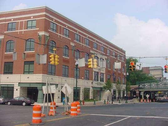
7 1) Economic Anchors Economic anchors within a downtown core draw steady crowds, which create active street life and encourage spin-off businesses.

8 1) Economic Anchors Economic anchors within a downtown core draw steady crowds, which create active street life and encourage spin-off businesses.

9 1) Economic Anchors Economic anchors within a downtown core draw steady crowds, which create active street life and encourage spin-off businesses.
10 1) Economic Anchors Economic anchors within a downtown core draw steady crowds, which create active street life and encourage spin-off businesses.


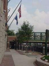
11 2) Architectural Integrity Traditional architecture provides a sense of place for a downtown and encourages a mix of uses that support a vibrant social and economic structure.


12 2) Architectural Integrity Reuse and revitalization of old buildings maintains a city s character and identity.

13 3) Mixed-use Development (Live, Work, & Play) Downtown buildings with restaurants, and pedestrian oriented commercial space on the first floor - office and residential space on the upper floors create a pedestrian presence, stable consumer population and customer base 24/7. Quality new mixed-use downtown development. Re-use of established architectural icons in a downtown environment.

14 3) Mixed-use Commercial Development To Optimize Downtown Retail Potential Strengthen existing retail offerings through financial assistance, marketing and promotion Introduce additional retail activity Cluster complementary retail Lifestyle market family activities, outdoor recreation, antiques, etc Create stable population with office and residential space in the downtown

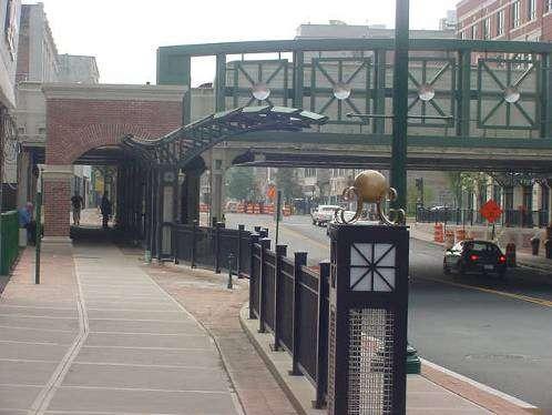
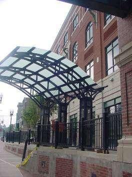
15 4) Vehicular Routes, Access to Mass Transit & Pedestrian Access that provide easy movement into and through the Downtown Core. Access to Mass Transit near Downtown Core. In the contemporary metropolis, development must adequately accommodate automobiles. It should do so in ways that respect the pedestrian and the form of public space. Douglas Farr


16 4) Vehicular Routes, Access to Mass Transit & Pedestrian Access that provide easy movement into and through the Downtown Core. Safe downtown pedestrian and bicycle zones promote an active downtown. In the contemporary metropolis, development must adequately accommodate automobiles. It should do so in ways that respect the pedestrian and the form of public space. Douglas Farr
17 4) Vehicular Routes, Access to Mass Transit & Pedestrian Access that provide easy movement into and through Downtown Undefined traffic routes and pedestrian crossings offer confusion and dangerous situations

18 4) Vehicular Routes, Access to Mass Transit & Pedestrian Access that provide easy movement into and through Downtown The vehicular and Pedestrian flow within a downtown should be clear and well marked.
19 5) Quality Pedestrian and Outdoor Spaces Wasted opportunity adjacent to downtown Quality pedestrian spaces should provide effective and inviting links between important parts of the City.
20 5) Quality Pedestrian and Outdoor Spaces Important axial relationship ignored Quality pedestrian spaces should provide effective and inviting links between important parts of the City.
21 5) Quality Pedestrian and Outdoor Spaces Gateway to open space Quality pedestrian spaces should provide effective and inviting links between important parts of the City.
22 5) Quality Outdoor Urban Spaces Outdoor urban spaces should provide areas for safe active and passive use. The measure of any great civilization is its cities and the measure of a city s greatness is to be found in the quality of its public spaces, it parks and squares. John Ruskin

23 5) Quality Outdoor Urban Spaces The measure of any great civilization is its cities and the measure of a city s greatness is to be found in the quality of its public spaces, it parks and squares. John Ruskin

24 5) Quality Outdoor Urban Spaces The measure of any great civilization is its cities and the measure of a city s greatness is to be found in the quality of its public spaces, it parks and squares. John Ruskin

25 5) Quality Outdoor Urban Spaces The measure of any great civilization is its cities and the measure of a city s greatness is to be found in the quality of its public spaces, it parks and squares. John Ruskin

26 5) Quality Outdoor Urban Spaces The measure of any great civilization is its cities and the measure of a city s greatness is to be found in the quality of its public spaces, it parks and squares. John Ruskin

27 5) Quality Outdoor Urban Spaces The measure of any great civilization is its cities and the measure of a city s greatness is to be found in the quality of its public spaces, it parks and squares. John Ruskin
28 6) Historic, Cultural, and Regional Context Recognition of historic, cultural and regional character promotes a sense of identity. Agri-Tourism Historic Architecture Rural Landscapes Industrial Heritage Transportation Heritage
29 6) Historic, Cultural, and Regional Context Agri-Tourism Historic Architecture Rural Landscapes Industrial Heritage Transportation Heritage

30 6) Historic, Cultural, and Regional Context Agri-Tourism Historic Architecture Rural Landscapes Industrial Heritage Transportation Heritage

31 6) Historic, Cultural, and Regional Context Agri-Tourism Historic Architecture Rural Landscapes Industrial Heritage Transportation Heritage

32 6) Historic, Cultural, and Regional Context Agri-Tourism Historic Architecture Rural Landscapes Industrial Heritage Transportation Heritage
33 6) Historic, Cultural, and Regional Context Agri-Tourism Historic Architecture Rural Landscapes Industrial Heritage Transportation Heritage
34 7) Natural Resources/ Environmental Context Preservation, celebration, and effective use of a regions natural resources improves the quality of life and attracts consumers. Protect Municipal Watersheds Provide Tourist Revenue Maintain Sense of Place Preserve Environmental Quality

35 7) Natural Resources/ Environmental Context Protect Municipal Watersheds Provide Tourist Revenue Maintain Sense of Place Preserve Environmental Quality
36 7) Natural Resources/ Environmental Context Protect Municipal Watersheds Provide Tourist Revenue Maintain Sense of Place Preserve Environmental Quality

37 7) Natural Resources/ Environmental Context Protect Municipal Watersheds Provide Tourist Revenue Maintain Sense of Place Preserve Environmental Quality

38 7) Natural Resources/ Environmental Context Protect Municipal Watersheds Provide Tourist Revenue Maintain Sense of Place Preserve Environmental Quality

39 7) Natural Resources/ Environmental Context Protect Municipal Watersheds Provide Tourist Revenue Maintain Sense of Place Preserve Environmental Quality


40 7) Natural Resources/ Environmental Context Protect Municipal Watersheds Provide Tourist Revenue Maintain Sense of Place Preserve Environmental Quality
41 8) Downtown Residential Options Urban living - when made a desirable, and an affordable option has many advantages for residents and tax payers

42 8) Downtown Residential Options Most communities do not market urban living as a desired housing option - but communities that do have more vibrant downtowns.

43 8) Downtown Residential Options Most communities do not market urban living as a desired housing option - but communities that do have more vibrant downtowns.

44 8) Downtown Residential Options Most communities do not market urban living as a desired housing option - but communities that do have more vibrant downtowns.

45 8) Downtown Residential Options Most communities do not market urban living as a desired housing option - but communities that do have more vibrant downtowns.

46 8) Downtown Residential Options Most communities do not market urban living as a desired housing option - but communities that do have more vibrant downtowns.
47 8) Downtown Residential Options Most communities do not market urban living as a desired housing option - but communities that do have more vibrant downtowns.
48 9) Supporting Commercial and Residential Districts

49 9) Supporting Commercial and Residential Districts Existing - Black River Boulevard, Rome, NY Proposed - Black River Boulevard, Rome, NY Proposed Improvements - Façade Improvements - Landscaping - Uniform and regulated signage - Consolidated curb-cuts - Shared parking - Street tree planting - Continue downtown streetscape amenities into commercial corridor - Setback requirement for new development - Parking to side and rear for new development


50 What can kill your Downtown! Traffic is spread out through a network of linkages. Distances are short, vehicular travel easy, pedestrian routes safe. Traffic is concentrated on one road. Pedestrian safety is jeopardized, driving is a hassle, strip mall development springs up and drains economics and life out of downtown core. Traditional Village Development Unplanned Suburban Development
51 CASE STUDIES

52 Regenerating an Urban Space Schenectady, NY Good aesthetic breeds good economics R. Eats
53 Regenerating an Urban Space Schenectady, NY

54 Regenerating an Urban Space Schenectady, NY

55 Regenerating an Urban Space Schenectady, NY

56 Regenerating an Urban Space Schenectady, NY

57 Regenerating an Urban Space Schenectady, NY

58 Regenerating an Urban Space Schenectady, NY

59 Regenerating an Urban Space Schenectady, NY
60 Regenerating an Urban Space Schenectady, NY
61 Regenerating an Urban Space Schenectady, NY
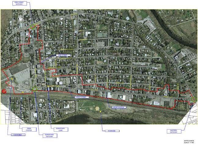
62 THE VISIONING PROCESS PORT JERVIS, NY THROUGH A SERIES OF MEETINGS THE COMMUNITY AND THE CONSULTANT TEAM WERE ABLE TO IDENTIFY THE ASSETS AND LIABILITIES WITHIN THE CITY OF PORT JERVIS. SPECIAL CARE WAS TAKEN TO DIRECT THE COMMUNITY S IDEAS TO CONCERNS AND ISSUES THAT WERE RELATED TO THE PHYSICAL DESIGN OF THEIR CITY (THE ANATOMY OF A VIBRANT DOWNTOWN).


63 THE VISIONING PROCESS Assets Railroad History/Access Riverfront Development Potential Geographic Location First Steps City Infrastructure Community Pride Walkable Downtown Low Crime History Delaware River IDENTIFY THOSE THAT RELATE TO DESIGN! PORT JERVIS, NY Liabilities Lack of Passenger Rail Lack of Cultural Activities No Movie Theater Limited Hotels Apathy Welfare Garbage CDA Lack of Communication b/w City Depts. Absentee Owners Vacant Commercial No Train Station Lack of Coordination in Attracting Tourists

64 THE VISIONING PROCESS PORT JERVIS, NY EXAMPLES OF SELECTED ASSETS MUNICIPAL ANCHORS

65 THE VISIONING PROCESS PORT JERVIS, NY EXAMPLES OF SELECTED ASSETS THE FRAMEWORK FOR TRADITIONAL MULTI-USE BUILDINGS IN THE DOWNTOWN.


66 THE VISIONING PROCESS PORT JERVIS, NY EXAMPLES OF SELECTED ASSETS PUBLIC OPEN SPACE ADJACENT TO DOWNTOWN
 UNDEVELOPED/ IGNORED PEDESTRIAN")
67 THE PLANNING PROCESS PORT JERVIS, NY EXAMPLES OF SELECTED LIABILITIES (OPPORTUNITIES) UNDEVELOPED/ IGNORED PEDESTRIAN ACCESS LINKS
 CONFUSING AND ISOLATED ACCESS TO")
68 THE PLANNING PROCESS PORT JERVIS, NY EXAMPLES OF SELECTED LIABILITIES (OPPORTUNITIES) CONFUSING AND ISOLATED ACCESS TO DOWNTOWN
 POORLY DEFINED PEDESTRIAN SAFETY ZONES AND DRIVING")
69 THE PLANNING PROCESS PORT JERVIS, NY EXAMPLES OF SELECTED LIABILITIES (OPPORTUNITIES) POORLY DEFINED PEDESTRIAN SAFETY ZONES AND DRIVING CORRIDORS
 ARCHITECTURAL HOLES IN")
70 THE PLANNING PROCESS PORT JERVIS, NY EXAMPLES OF SELECTED LIABILITIES (OPPORTUNITIES) ARCHITECTURAL HOLES IN DOWNTOWN

 SHOPPING/")
71 THE PLANNING PROCESS PORT JERVIS, NY EXAMPLES OF SELECTED LIABILITIES (OPPORTUNITIES) SHOPPING/ RESIDENTIAL CORRIDORS
 Every year")

72 THE PLANNING PROCESS PORT JERVIS, NY EXAMPLES OF SELECTED LIABILITIES (OPPORTUNITIES) Every year hundreds of thousands of visitors canoe and raft down the Delaware River UNTAPPED POTENTIAL

 UNTAPPED")
73 THE PLANNING PROCESS PORT JERVIS, NY EXAMPLES OF SELECTED LIABILITIES (OPPORTUNITIES) UNTAPPED POTENTIAL
74 THE PLANNING PROCESS PORT JERVIS, NY EXAMPLES OF SELECTED LIABILITIES (OPPORTUNITIES) NO ECONOMIC ANCHOR

75 THE VISIONING PROCESS PORT JERVIS, NY REDEFINE VEHICULAR ACCESS TO DOWNTOWN SOME INNOVATIVE SOLUTIONS PROVIDE SAFE, ACCESSIBLE PEDESTRIAN ZONES AND DEFINED DRIVING AREAS. PROVIDE LINKS TO IMPORTANT PARTS OF THE CITY

76 THE VISIONING PROCESS PORT JERVIS, NY SOME INNOVATIVE SOLUTIONS

77 THE VISIONING PROCESS PORT JERVIS, NY SOME INNOVATIVE SOLUTIONS DEVELOP ECONOMIC ANCHOR WITH RETAIL AND MUSEUM SPACE REDEFINE VEHICULAR ACCESS TO DOWNTOWN

78 THE VISIONING PROCESS PORT JERVIS, NY SOME INNOVATIVE SOLUTIONS

79 THE VISIONING PROCESS PORT JERVIS, NY SOME INNOVATIVE SOLUTIONS PEDESTRIAN LINK COMMERCIAL INFILL IMPROVED STREETSCAPE AND CROSS SECTION

80 THE VISIONING PROCESS PORT JERVIS, NY SOME INNOVATIVE SOLUTIONS

81 THE VISIONING PROCESS PORT JERVIS, NY SOME INNOVATIVE SOLUTIONS PROVIDE NEIGHBORHOOD PARK PEDESTRIAN LINK TO DOWNTOWN ECONOMIC ANCHOR WATERFRONT PARK WITH WATER ACCESS

82 THE VISIONING PROCESS PORT JERVIS, NY SOME INNOVATIVE SOLUTIONS
83 Anatomy of A Vibrant Downtown Laberge Group Benjamin H. Syden, AICP Director of Planning & Community Development 4 Computer Drive West Albany, NY TEL: SYNTHESIS Ian C. Law Graduate Landscape Architect 162 Jay St Schenectady, NY TEL:
Laberge Group. Town of Coeymans. Draft Comprehensive Plan. Overview of Planning Process
 Draft : Presentation of Goals & Strategies Laberge Group Benjamin H. Syden, A.I.C.P., E.D.P Director in Charge Nicole Allen, A.I.C.P. Senior Planner Anjali Malhotra Planner Presentation Outline Introductions
Lambeth Main Street Streetscape Improvements
 Lambeth Main Street Streetscape Improvements Open House October 5th, 2017 Agenda 1. Introduction 2. Project Background 3. Context 4. Project Objectives 5. Design Principles & Approach 6. Streetscape Design
City of Long Beach. creating vibrant and exciting places
 City of Long Beach creating vibrant and exciting places Land Use Element Urban Design Element Overview of the two draft General Plan elements Discuss areas of change Economic goals of the plans Case study
TOWN COUNCIL / PLANNING COMMISSION
 Workshop #3 TOWN COUNCIL / PLANNING COMMISSION January 20, 2011 Consultant Team In Attendance Tonight BMS Design Group Nevada City and San Francisco Michael Smiley, AICP, ASLA Partner-in-Charge Nancy L.
Dyersville Downtown Plan. Open House October 24, 2017
 Dyersville Downtown Plan Open House October 24, 2017 What is a Comprehensive Plan? - Vision - Guidance for decisions - Basis for regulations What is a Downtown Plan? - Understand priorities - Identify
City of Farmington. Downtown Plan. Amendment to the 1998 Master Plan Adopted October 11, 2004
 City of Farmington Amendment to the 1998 Master Plan Adopted October 11, 2004 Introduction Planning Background 1 Scope and Components of the Plan Amendment 2 Concept Introduction 3 Plan Concepts 3 Conceptual
U T D N o r t h C a m p u s T O D and D o w n t o w n D e n t o n T O D
 U n i v e r s i t y o f T e x a s a t D a l l a s C i t y o f R i c h a r d s o n U T D N o r t h C a m p u s T O D and D o w n t o w n D e n t o n T O D Rick Leisner, AICP Assistant Director of Development
Land Use. Hardware Street Vendor Mixed-Use
 Land Use Definition Land Use is the way a piece of real estate is utilized. Existing, proposed, and adopted land uses all play a role in the planning process. Once a land use plan is adopted, the next
Table of Contents. Elm Avenue Improvement Plan City of Waco, Texas. Introduction 1. Existing Context 1 Figure 1 2.
 Table of Contents Introduction 1 Existing Context 1 Figure 1 2 Plan Guidelines 3 Future Urban Form 4 The West-End 4 Main Street 6 The East-End 7 Figure 2 9 Public Improvement Recommendations 7 General
V. Gateways GATEWAYS / V-1
 V. GATEWAYS / V-1 Many of Chesapeake s gateways are located on highways and call for bold and attractive designs that motorists can understand, appreciate, and enjoy. can also take the form of natural
SARANAC LAKE VISION CONCEPTS
 DRAFT SARANAC LAKE VISION CONCEPTS A GENUINE PLACE TO LIVE, WORK, SHOP AND EXPERIENCE CULTURE IN THE HEART OF THE ADIRONDACKS PHOTO COURTESY OF SARANAC LAKE SARANAC LAKE, NEW YORK DECEMBER 2007 SARANAC
A BLUEPRINT FOR BROCKTON A CITY-WIDE COMPREHENSIVE PLAN
 A BLUEPRINT FOR BROCKTON A CITY-WIDE COMPREHENSIVE PLAN Public Meeting October 2016 1 Plan Summary and Discussion Public Meeting May 4 2017 City of Brockton Bill Carpenter, Mayor Department of Planning
About Momentum Midland
 About Momentum Midland Achieving a community s full potential in terms of economic development and quality of life is critically important to its long term sustainability. Core to achieving this is a vibrant
In surveys, Dallas residents say what they want to change most
 NEIGHBORHOODS ELEMENT In surveys, Dallas residents say what they want to change most in the city is its appearance they want it to look beautiful, with trees and pedestrian-friendly neighborhoods. The
SECTION ONE: INTRODUCTION. introduction
 introduction 1 INTRODUCTION Since it was first established in 1843 as a trading post for the Hudson s Bay Company, Victoria has evolved into a Provincial capital city that is recognized across Canada and
EXISTING COMPREHENSIVE PLAN
 EXISTING COMPREHENSIVE PLAN Town Center Land Use Element: V. LAND USE POLICIES Town Center Mercer Island's business district vision as described in "Your Mercer Island Citizen-Designed Downtown" was an
LUNDY S LANE COMMUNITY IMPROVEMENT PLAN STUDY
 PUBLIC INFORMATION MEETING #2 October 12, 2016 LUNDY S LANE COMMUNITY IMPROVEMENT PLAN STUDY AGENDA 5:00 to 5:30pm: Open House 5:30 to 6:15pm: Presentation 6:15 to 7:00pm: Individual paced workshop with
Urban Analysis. Downtown Zanesville like any city, has been physically modified through time as it
 Urban Analysis As a part of the consulting team s reconnaissance effort, an urban analysis was performed. Before the future of a place can be envisioned, one must understand the physical characteristics
Visioning Statement and Guiding Principles
 Visioning Statement and Guiding Principles Planning for the Future The General Plan The General Plan represents Woodland's shared vision of the future and defines a path to lead the community toward its
Niagara National Heritage Area
 Niagara National Heritage Area What is a National Heritage Area? It is a regional place where natural, cultural, historic and recreational resources combine to form a nationally distinctive landscape and
Potential Green Infrastructure Strategies May 6, 2015 Workshop
 Potential Green Infrastructure Strategies May 6, 2015 Workshop Background The City of Cortland is developing the Tioughnioga Urban Headwaters Green Infrastructure Action Plan with funding from the National
KAMPLAN City of Kamloops. Section D. Land Use Policies D-1
 KAMPLAN City of Kamloops Section D Land Use Policies D-1 City of Kamloops KAMPLAN D 1 Land Management and Development This section links to the following Community Values: D-2 develop complete neighbourhoods
Ivywild On The Creek PRELIMINARY CREEK DISTRICT MASTER PLAN
 Ivywild On The Creek PRELIMINARY CREEK DISTRICT MASTER PLAN Introduction: Rejuvenating an extraordinary Creekside neighborhood THE CREEKSIDE DISTRICT The Ivywild On The Creek Neighborhood District Master
WELCOME and introduction
 1 WELCOME and introduction Mobility Hub Locations within Burlington STUDY OVERVIEW STUDY OBJECTIVES The City of Burlington is developing four Area Specific Plans, one for each of Burlington s Mobility
Town Center (part of the Comprehensive Plan)
") Town Center (part of the Comprehensive Plan) Mercer Island Town Center Looking North (2014) In 1994, a year-long process culminated in a set of design guidelines and code requirements for the Town Center
Town Center (part of the Comprehensive Plan) Mercer Island Town Center Looking North (2014) In 1994, a year-long process culminated in a set of design guidelines and code requirements for the Town Center
Mark-up of the effect of the proposed Bronte Village Growth Area OPA No.18 on the text of section 24, Bronte Village, of the Livable Oakville Plan
 Mark-up of the effect of the proposed Bronte Village Growth Area OPA No.18 on the text of section 24, Bronte Village, of the Livable Oakville Plan Notes: This document is provided for information purposes
Downtown Streetscape Manual & Built Form Standards
 City of Guelph Downtown Streetscape Manual & Built Form Standards July 2014 Prepared by Brook McIlroy Inc. in association with Unterman McPhail Associates and McCormick Rankin Inc. City of Guelph Downtown
Complete Neighbourhood Guidelines Review Tool
 Complete Neighbourhood Guidelines Review Tool Prepared By: City of Regina Planning Department October 2014 Page 1 of 14 Community Development Review Checklist for Secondary Plans and Concept Plans The
8implementation. strategies
 PROGRAM STRATEGIES 8implementation strategies T he implementation actions of this chapter are designed to support and carry out the land use, economic development, transportation, urban design, and program
PINE CURVE REZONING. Property does not meet criteria for open space preservation and is not a candidate for a park
 PINE CURVE REZONING BACKGROUND Purchased as two parcels in 2001 and 2002 Annexed and Zoned Greater Downtown District Historic Center September 25, 2002 and October 7, 2002 WHAT THE PROJECT IS AND IS NOT
hermitage town center
 hermitage town center A Community Vision prepared by Strada for The City of Hermitage and The Mercer County Regional Planning Commission January 2007 table of contents introduction 3 design principles
Regional Placemaking: Connecting Towns as Places
 Regional Placemaking: Connecting Towns as Places Philip Myrick, Project for Public Spaces Corning, NY May 13, 2009 30 years - 1000 communities - 46 states - 12 countries Two City Streets It is difficult
Copake Hamlet Plan: Visioning Workshop
 Copake Hamlet Plan: May 2-3 rd 2015 Design Team Mauricio Castro PLACE Alliance Ian Law PLACE Alliance Paula Diaz PLACE Alliance Mary Moore Wallinger PLACE Alliance Margaret Irwin River Street Planning
THEMES, VISION, + PRINCIPLES
 CHAPTER 2: THEMES, VISION, + PRINCIPLES This page intentionally left blank. 20 VISION DRAFT AUGUST 2018 2 2 THEMES, VISION, + GUIDING PRINCIPLES The Key Themes, Vision, and Guiding Principles presented
Presentation of the Staff Draft. July 17, 2014 SSRVP Team, Area 3
 Presentation of the Staff Draft July 17, 2014 SSRVP Team, Area 3 Presentation Overview Introduction Plan Framework Plan Recommendations Implementation Next Steps and Request for Public Hearing on September
Broadway District Specific Plan. Community Workshop #2 February 23,2016
 Broadway District Specific Plan Community Workshop #2 February 23,2016 1 Agenda Introductions Project Progress Status Upcoming Milestones Emerging Framework Land Use Urban Design Circulation Infrastructure
TEAM INPUT SUMMARY. Postcard Image?
 DOWNTOWN MAULDIN TEAM PUBLIC INPUT TEAM INPUT SUMMARY Postcard Image? A nice neighborhood The main city center with government buildings Mauldin entry sign, high school, Cultural Center, Sunset Park, Hall
Table L-1 Summary Action Strategy. Action Item Timing Status Responsible Agency
 CHAPTER 4: CIRCULATION ELEMENT ISSUE #1: MAJOR THOROUFARES AND TRANSPORTATION ROUTES A balanced transportation system for Fontana is provided that meets the mobility needs of current and future residents
Moss Point. Steve Schukraft Todd Meyer Dhaval Barbhaya Clyde Judson
 Moss Point Steve Schukraft Todd Meyer Dhaval Barbhaya Clyde Judson Moss Point Presentation 1. Analysis 2. Vision 3. Plan 4. Discussion Moss Point Agenda Presentation 1. Context 2. Emerging Vision 3. Plans
Policies and Code Intent Sections Related to Town Center
 Policies and Code Intent Sections Related to Town Center The Town Center Vision is scattered throughout the Comprehensive Plan, development code and the 1994 Town Center Plan. What follows are sections
Port Lavaca Future Land Use
 Port Lavaca Future Land Use Introduction The City of Port Lavaca is beginning to see sustained growth, after many years of relative stable population. New single family homes, apartments, and businesses
DRAFT ROOSEVELT ROAD. District Recommendations. Figure 5.23 The Roosevelt Road Corridor
 CHAPTER 5 Figure 5.23 The Road Corridor Road will develop as a mixed-use corridor, emphasizing regional retail, west of the river and mixed-use development east of the river. KEY RECOMMENDATIONS 1. High
Chapter 4. Linking Land Use with Transportation. Chapter 4
 Chapter 4 Linking Land Use with Transportation Chapter 4 59 Chapter 4 Linking Land Use with Transportation Community Design and Transportation Program Introduction Since the 1950s, the predominant development
LAND USE ELEMENT. Purpose. General Goals & Policies
 LAND USE ELEMENT Purpose This Land Use Element contains the goals and policies necessary to support the City s responsibility for managing land resources and guiding development through implementing regulations,
The transportation system in a community is an
 7 TRANSPORTATION The transportation system in a community is an important factor contributing to the quality of life of the residents. Without a sound transportation system to bring both goods and patrons
GUIDELINES EXHIBITION PLACE LOCATION: OBJECTIVES. Structure Plan URBAN DESIGN GUIDELINES
 Development in the Exhibition Place lands will be consistent with the following urban design guidelines. They provide a framework for new development of the lands and are to be read in conjunction with
WATERFORD Plan of Preservation, Conservation and Development Supplement Part 1 - Policy Element
 WATERFORD 2012 Plan of Preservation, Conservation and Development 2015 Supplement Part 1 - Policy Element Effective June 11, 2015 2015 Plan Update GOAL To respond to the evolving land use needs and continually
[PLANNING RATIONALE] For Site Plan Control and Lifting of Holding Zone By-Law 101 Champagne Avenue. May 23, 2014
![[PLANNING RATIONALE] For Site Plan Control and Lifting of Holding Zone By-Law 101 Champagne Avenue. May 23, 2014](/thumbs/75/71599615.jpg "[PLANNING RATIONALE] For Site Plan Control and Lifting of Holding Zone By-Law 101 Champagne Avenue. May 23, 2014") [PLANNING RATIONALE] For Site Plan Control and Lifting of Holding Zone By-Law 101 Champagne Avenue May 23, 2014 Contents 1.0 Introduction... 2 2.0 Site Context... 2 2.1 Adjacent Uses... 2 Figure 1: Site
[PLANNING RATIONALE] For Site Plan Control and Lifting of Holding Zone By-Law 101 Champagne Avenue May 23, 2014 Contents 1.0 Introduction... 2 2.0 Site Context... 2 2.1 Adjacent Uses... 2 Figure 1: Site
7. Main Street Revitalization. Fact Sheet
 7. Main Street Revitalization Fact Sheet Many towns in the Hartford region have old town centers in varying degrees of economic health. While some are attractive and popular places, other town centers
6. DOWNTOWN. The Downtown Element focuses on supporting and expanding the vitality and enhancement of Downtown Chico as the City s central core.
 VISION In 2030, Downtown Chico is the heart of the community and the center of cultural activity. Engaging and active at the street level, it is a multi-story, mixed-use hub, with specialty retail, restaurants,
expectations for new development W A T E R F R O N T D R I V E
 expectations for new development W A T E R F R O N T D R I V E 1 April 2004 W A T E R F R O N T D R I V E expectations for new development Introduction and Intent This statement of expectations for development
ELK GROVE GENERAL PLAN VISION
 2-1 CHAPTER 2: 2-2 CREATING OUR The Community Vision for Elk Grove, expressed through a Vision Statement and a series of Supporting Principles, is a declaration of the kind of community that Elk Grove
Creating a Main Street Strategy A Roadmap to a Community s Future
 Creating a Main Street Strategy A Roadmap to a Community s Future Creating a Main Street Strategy A Roadmap to a Community s Future 9:00 am Session 1: Creating a Main Street Strategy A Roadmap to a Community
CHAPTER 6: Community Design and Appearance
 AGLE AREA COMMUNITY Plan CHAPTER 6 CHAPTER 6: Community Design and Appearance Community Design and Appearance How a community is designed and what a community looks like are attributes fundamental to the
Plano Tomorrow Vision and Policies
 Plano Tomorrow Vision and Policies PLANO TOMORROW PILLARS The Built Environment The Social Environment The Natural Environment The Economic Environment Land Use and Urban Design Transportation Housing
Project Profile BAR HARBOR
 1 BAR HARBOR The Bar Harbor Master Plan merges community vision with design guidelines to preserve the unique character of Bar Harbor Village. PROJECT SUMMARY Overview: The economic vitality of Bar Harbor
EXHIBIT A. Tax Increment Reinvestment Zone No. 1 (Town Center) First Amended Project Plan 1
 First Amended Project Plan 1") EXHIBIT A Tax Increment Reinvestment Zone No. 1 (Town Center) First Amended Project Plan 1 1 As amended by Resolution No. 2008-02-001(TR1R) of the Tax Increment Reinvestment Zone No.1, and approved to
EXHIBIT A Tax Increment Reinvestment Zone No. 1 (Town Center) First Amended Project Plan 1 1 As amended by Resolution No. 2008-02-001(TR1R) of the Tax Increment Reinvestment Zone No.1, and approved to
V. Vision and Guiding Principles
 V. Vision and Guiding Principles The Master Plan for the Powers Ferry Corridor seeks a foundation in the desires of the community. At times, various elements of the community offered opposing viewpoints,
DALY CITY VISIONING PROCESS COMMUNITY WORKSHOP 3 MAY 8, 2008
 DALY CITY VISIONING PROCESS COMMUNITY WORKSHOP 3 MAY 8, 2008 PROCESS General Plan - a statement of the community s values, vision and aspirations for now and into the future... Timeframe LONG TERM - 2030
URBAN DESIGN BRIEF REPORT
 URBAN DESIGN BRIEF REPORT PREPARED FOR 2568401 ONTARIO INC NEW GASBAR, CONVENIENCE STORE & CARWASH DEVELOPMENT @ 1509 FANSHAWE PARK ROAD WEST LONDON, ONTARIO GAMA ENGINEERING INC. PROJECT NUMBER 1669 PREPARED
Commercial, Retail and Tourism Executive Summary December 2018
 Town of Wasaga Beach Official Plan Review, Retail and Executive Summary December 2018 1 An Official Plan directs where and how to grow The preparation of a new Official Plan for Wasaga Beach is an opportunity
DRAFT. October Wheaton. Design Guidelines
 October 2011 DRAFT Wheaton Design Guidelines 2 Draft - Design Guidelines - Wheaton Sector Plan Contents 04 Section 1: Introduction 06 Section 2: Context 08 Section 3: Design Guidelines 09 Goal 1: Create
PLANNING ADVISORY BOARD AGENDA OCTOBER
 ! City of Langley PLANNING ADVISORY BOARD AGENDA OCTOBER 1, 2014 3-5pm LANGLEY CITY HALL - 112 2 nd Street, Langley WA 1) Call to Order and Roll Call 2) Approval of the Minutes September 10, 2014 3) Public
Clairtrell Area Context Plan
 Clairtrell Area Context Plan March 2005 Urban Development Services City Planning Contents 1. Introduction... 4 2. Development Structure... 6 2.1 Streets... 7 2.1.1 Sheppard Avenue and Bayview Avenue...
FUTURE LAND USE ELEMENT
 FUTURE LAND USE ELEMENT GOAL I: To create and sustain a great place to live, play, and prosper Objective 1: The City of Ocala shall incorporate the principles and strategies of the Ocala 2035 Vision into
THE NEIGHBORHOOD TODAY
 THE NEIGHBORHOOD TODAY CORE AREA VISION How are we Good Urbanism A Site s DNA thinking about Elements of great Unique elements urban communities embedded in a place the site and design? ELEMENTS LIKE:
What Pioneer Grove Will Look Like?
 The City of Deerfield Beach has embarked on a journey to create a new town center within the old heart of Deerfield Beach. The new town center is known as Pioneer Grove. Pioneer Grove will be Everybody
MALL REVITALIZATION CASE STUDIES
 MALL REVITALIZATION CASE STUDIES DECEMBER 9, 2012 MALL REVITALIZATION OVERVIEW Introduction Sample Case Studies prepared for Lacey Woodland District Steering Committee as it considers strategies to revitalize
Brian Madigan, RLA, CPESC Director Land Planning & Design
 Brian Madigan, RLA, CPESC Director Land Planning & Design bmadigan@gymodpc.com Architecture, Engineering & Land Surveying, DPC 18969 US Route 11 Watertown, New York 13601 T: (315) 788-3900 F: (315) 788-0668
Ship Creek Redevelopment
 Ship Creek Redevelopment Three Concepts May 2013 Cambridge ARCHITECTURE Philadelphia ENGINEERING Raleigh INTERIORS San Francisco PLANNING Washington, DC www.klingstubbins.com contact@klingstubbins.com
Welcome. Walk Around. Talk to Us. Write Down Your Comments
 Welcome This is an information meeting introducing the applications for proposed redevelopment of the Yorkdale Shopping Centre site at 3401 Dufferin Street and 1 Yorkdale Road over the next 20+ years,
Committee Meeting: Downtown Today & Concept Refinement September 11, 2017
 Committee Meeting: Downtown Today & Concept Refinement September 11, 2017 AGENDA 1. Brief Input Update 2. Comprehensive Plan Principles 3. Downtown Today 4. Concept Updates 5. Future Schedule What is a
PUBLIC REALM STUDY AREA
 WELCOME PUBLIC REALM STUDY AREA WHAT IS PUBLIC REALM? Welcome to the Ballina Town Public Realm public consultation event. Mayo Council is in the process of producing a Public Realm Strategy for Ballina
URBAN DESIGN BRIEF. Terms of Reference. Purpose. When is an Urban Design Brief Required
 Purpose An Urban Design Brief (UDB) is intended to describe and illustrate proposed designs for new development projects and demonstrate how the City s Urban Design Guidelines and other City policies have
University of Saskatchewan CAMPUS MASTER PLAN. Senate Meeting Preliminary Presentation. April 21, 2018 DIALOG ECS DA WATT
 University of Saskatchewan CAMPUS MASTER PLAN Senate Meeting Preliminary Presentation April 21, 2018 DIALOG ECS DA WATT project process presentation agenda Stakeholder Engagement Project Control phase1
Appendix A COMMUNITY IMPROVEMENT PLAN DESIGN GUIDELINES
 Appendix A COMMUNITY IMPROVEMENT PLAN DESIGN GUIDELINES INTRODUCTION The continuous and desirable improvement of Arnprior requires a clear understanding of what is envisioned for the Town. These Design
The Five Components of the McLoughlin Area Plan
 The Five Components of the McLoughlin Area Plan This documents contains the complete language of the five components of the McLoughlin Area Plan: The Vision Statement The Values The Guiding Principles
Hockessin Community Redevelopment Plan
 Hockessin Community Redevelopment Plan 3.1 Introduction The Community Redevelopment Plan for the Village of Hockessin is the result of the people s vision for a distinct village center that serves as the
Corridor Transformation Strategy
 Corridor Transformation Strategy County Road 22 Special Planning Area Design Guidelines January 2012 D14-06017 Corridor Transformation Strategy County Road 22 Special Planning Area Corridor Design Guidelines
Village of Fair Haven Goals & Objectives
 Village of Fair Haven Goals & Objectives 1 Natural Environmental Quality & Aesthetics Embrace policies and programs that preserve and enhance the Village s natural resources, environment, water quality,
PINE CURVE REZONING. BACKGROUND Purchased as two parcels in 2001 and 2002
 BACKGROUND Purchased as two parcels in 2001 and 2002 WHAT THE PROJECT IS AND IS NOT A Rezoning establishes the land use standards for Annexed and Zoned Greater Downtown District Historic Center September
Urban Design Manual PLANNING AROUND RAPID TRANSIT STATIONS (PARTS) Introduction. Station Study Areas
 Introduction. Station Study Areas") 111111 PLANNING AROUND RAPID TRANSIT STATIONS (PARTS) Introduction The ION rapid transit system will link Waterloo, Kitchener and Cambridge through a central transit corridor (CTC). There are a number
111111 PLANNING AROUND RAPID TRANSIT STATIONS (PARTS) Introduction The ION rapid transit system will link Waterloo, Kitchener and Cambridge through a central transit corridor (CTC). There are a number
Urban Design 9Identity
 Urban Design 9Identity URBAN DESIGN IDENTITY Urban design is about connecting people to their places through the built environment, nature, and overall urban form. Done well, it creates a memorable space
Gary & Regional Investment Project. October 27, Creating Tomorrow Today Comprehensive Regional Plan - NIRPC
 Creating Tomorrow Today 2040 Comprehensive Regional Plan Gary & Regional Investment Project October 27, 2010 Creating Tomorrow Today - 2040 Comprehensive Regional Plan - NIRPC What is NIRPC? - Northwestern
Downtown North Las Vegas Demonstration Site Project. Project Update
 Downtown North Las Vegas Demonstration Site Project Project Update 7.16.14 Presentation Overview Project Purpose and Process Planning Context Opportunities and Barriers Summary Community Input Preliminary
Comprehensive Plan & Station Area Zoning
 Village of Tarrytown Comprehensive Plan & Station Area Zoning Public Workshop November 5, 2017 Warner Library WXY architecture + urban design Pace University - Land Use Law Center George M. Janes & Associates
TEMPLE MEDICAL & EDUCATION DISTRICT
 City of Temple, Texas TEMPLE MEDICAL & EDUCATION DISTRICT 1 Description. The City of Temple joined in partnership with key public and private entities to jointly promote education and medical activities
Corridors. Re-vitalize our Corridors and Gateways
 Corridors Re-vitalize our Corridors and Gateways Artist s rendering from the 287 Strategic Plan, 2015 Corridors are the major throughways of Loveland but they also provide important commercial, community
Metro. Activity Center Design Guidelines. Recommendations For Developing Focused, Mixed-Use Commercial/Residential Centers
 Metro Activity Center Design Guidelines Recommendations For Developing Focused, Mixed-Use Commercial/Residential Centers Metro Activity Centers What is a MAC? Legacy, the adopted guide for the future growth
BRYN MAWR. Tier 2 Characteristics: Location: Lancaster Avenue from Old Lancaster Road on the east to Norwood Avenue on the west
 BRYN MAWR Tier 2 Characteristics: Transit-oriented Mixed use Along Lancaster Avenue Serve township-wide needs Civic space Employment centers Location: Lancaster Avenue from Old Lancaster Road on the east
Town of Cobourg Heritage Master Plan. Statutory Public Meeting
 Town of Cobourg Heritage Master Plan Statutory Public Meeting April 25 th 2016 Presentation Overview 1. Introduction 2. Project background and schedule overview 3. Review of strategic direction content
Lehigh Acres Land Development Regulations Community Planning Project
 Lehigh Acres Land Development Regulations Planning Effort Summary In July, 2010 Commissioner Frank Mann invited the Lehigh Acres community to start discussing how to achieve their recently adopted community
Executive Summary. The Mebane CLP is not a regulatory document, but is intended to guide land development decisions. The plan includes:
 Executive Summary P URPOSE AND O RGANIZATION OF THE P LAN The City of Mebane, with input from citizens and an appointed CLP Advisory Committee, adopted Mebane by Design, a Comprehensive Land Development
4.1.3 LAND USE CATEGORIES
 4.1.3 LAND USE CATEGORIES a. City Center District The City Center District incorporates the existing character and mix of uses in downtown Belmont to encourage redevelopment and new development in keeping
3. Urban Design in the Central Area
 3. Urban Design in the Central Area The Central Area Planning and Design Group assumes the responsibility to promote high quality urban and architectural design in the Central Area, plan and ensure the
The Village of Shirlington
 The Village of Shirlington Suburban Smart Growth Without Rail Transit July 2018 Agenda History (1940 to present) Attributes and Outcomes Lessons Learned Setting the Stage Arlington County Arlington is
DISCUSSION TOPIC: ST JOHNS RIVER & ITS TRIBUTARIES (BPII) 2030 COMPREHENSIVE PLAN POLICES AND REGULATORY FRAMEWORK
 2030 COMPREHENSIVE PLAN POLICES AND REGULATORY FRAMEWORK") DISCUSSION TOPIC: ST JOHNS RIVER & ITS TRIBUTARIES (BPII) 2030 COMPREHENSIVE PLAN POLICES AND REGULATORY FRAMEWORK St. John s River & Its Tributaries Issue Summary: The St. Johns River is an important
DISCUSSION TOPIC: ST JOHNS RIVER & ITS TRIBUTARIES (BPII) 2030 COMPREHENSIVE PLAN POLICES AND REGULATORY FRAMEWORK St. John s River & Its Tributaries Issue Summary: The St. Johns River is an important
Corridor Vision. 1Pursue Minnehaha-Hiawatha Community Works Project. Mission of Hennepin County Community Works Program
 1Pursue Minnehaha-Hiawatha Community Works Project Minnehaha-Hiawatha Community Works is a project within the Hennepin Community Works (HCW) program. The mission of the HCW program is to enhance how the
TABLE OF CONTENTS. Transportation Chapter 1 - Introduction and Purpose of Planning to 1-3. Utilities
 Chapter 1 - Introduction and Purpose of Planning... 1-1 to 1-3 Pennsylvania Municipalities Planning Code (Act 247)...1-1 Previous County Planning Activities...1-1 Objectives of the Plan...1-2 Elements
A. Background Summary of Existing Challenges and Potential Possibilities. 1. Summary of Existing Assets and Potential Opportunities
 A. Background 1 A Main Street Master Plan Study was performed and completed in October of 2007. The study was initiated to review current land uses and development patterns along Main Street, from Parrish