BANKHOUSE PUMPING STATION, MILLOM, CUMBRIA
|
|
|
- Delphia Bryant
- 5 years ago
- Views:
Transcription

1 BANKHOUSE PUMPING STATION, MILLOM, CUMBRIA Archaeological Watching Brief Oxford Archaeology North May 2006 United Utilities Issue No: /508 OA North Job No: L9397 NGR: SD
2 Document Title: Document Type: BANKHOUSE PUMPING STATION, MILLOM, CUMBRIA Archaeological Watching Brief Client Name: United Utilities Issue Number: /508 OA Job Number: L9397 National Grid Reference: SD Prepared by: David Tonks Position: Assistant Supervisor Date: May 2006 Checked by: Alison Plummer Signed. Position: Senior Project Manager Date: May 2006 Approved by: Alan Lupton Signed. Position: Operations Manager Date: May 2006 Document File Location Alison\projects\L9397/Bankhouse/Report Oxford Archaeology North Oxford Archaeological Unit Ltd 2006 Storey Institute Janus House Meeting House Lane Osney Mead Lancaster Oxford LA1 1TF OX2 0EA t: (0044) t: (0044) f: (0044) f: (0044) w: e: Oxford Archaeological Unit Limited is a Registered Charity No: Disclaimer: This document has been prepared for the titled project or named part thereof and should not be relied upon or used for any other project without an independent check being carried out as to its suitability and prior written authority of Oxford Archaeology being obtained. Oxford Archaeology accepts no responsibility or liability for the consequences of this document being used for a purpose other than the purposes for which it was commissioned. Any person/party using or relying on the document for such other purposes agrees, and will by such use or reliance be taken to confirm their agreement to indemnify Oxford Archaeology for all loss or damage resulting therefrom. Oxford Archaeology accepts no responsibility or liability for this document to any party other than the person/party by whom it was commissioned.
3 Bankhouse Pumping Station, Millom, Cumbria: Archaeological Watching Brief 1 CONTENTS SUMMARY...2 ACKNOWLEDGEMENTS INTRODUCTION Circumstances of the Project METHODOLOGY Watching Brief Archive BACKGROUND Topography and Geology Archaeological Background RESULTS Observations Finds CONCLUSIONS Discussion BIBLIOGRAPHY...9 Primary Sources...9 Secondary Sources...9 ILLUSTRATIONS...10 List of Figures...10 List of Plates...10
4 Bankhouse Pumping Station, Millom, Cumbria: Archaeological Watching Brief 2 SUMMARY Following a request by United Utilities, Oxford Archaeology North undertook a watching brief on specified groundworks during the construction of a proposed water transfer pumping station at Millom, Cumbria (SD ). The work was undertaken on 16 th and 17 th June The topsoil strip and the groundworks associated with construction were to be monitored by an archaeological presence. In the event, owing to communication failures, only the topsoil strip in advance of construction was monitored. No significant archaeology was found during the watching brief and there were no recommendations made for further archaeological intervention or work.
5 Bankhouse Pumping Station, Millom, Cumbria: Archaeological Watching Brief 3 ACKNOWLEDGEMENTS Thanks are due to United Utilities for commissioning the work and to the staff and contractors of Daniels for their help on site. OA North would also like to thank Jeremy Parsons, Assistant Archaeologist, Cumbria County Council, for his assistance. The watching brief was undertaken by Kathryn Blythe and David Tonks wrote the report. The drawings were produced by Mark Tidmarsh and the finds were examined by Sean McPhillips. The project was managed by Alison Plummer, who also edited the report.
6 Bankhouse Pumping Station, Millom, Cumbria: Archaeological Watching Brief 4 1. INTRODUCTION 1.1 CIRCUMSTANCES OF THE PROJECT Following the submission of a planning application by United Utilities for the proposed construction of a new water transfer pumping station at Millom, Cumbria (centred on SD ), United Utilities were advised that the proposed works affected an area of archaeological significance. Accordingly, a watching brief was requested by Cumbria County Council Archaeological Services (CCCAS) during specified groundworks associated with the project. Oxford Archaeology North (OA North) was duly commissioned to undertake the work which took place on 16 th and 17 th June This document sets out the results of the watching brief in the form of a short report.
7 Bankhouse Pumping Station, Millom, Cumbria: Archaeological Watching Brief 5 2. METHODOLOGY 2.1 WATCHING BRIEF The purpose of the programme of fieldwork was to record the location, extent, and character of any surviving archaeological features observed during the topsoil strip of the proposed site, and during groundworks associated with the construction of the pumping station. A photographic record in colour slide and monochrome formats was also compiled. The observed groundworks were effected by mechanical excavator equipped with a toothless bucket. 2.2 ARCHIVE A full professional archive has been compiled in accordance with current IFA and English Heritage guidelines (English Heritage 1991). The paper and digital archive will be deposited in the Cumbria Record Office, Barrow in Furness.
8 Bankhouse Pumping Station, Millom, Cumbria: Archaeological Watching Brief 6 3. BACKGROUND 3.1 TOPOGRAPHY AND GEOLOGY Millom is located on the south-west coast of Cumbria overlooking the Duddon Estuary and it lies within the West Cumbria Coastal Plain character area as defined by the Countryside Commission (Countryside Commission 1998, 25-30). The area is characterised by a varied open coastline of mudflats, shingle and pebble beaches (ibid). The majority of the inland area is a medium-scale pastoral landscape of undulating topography with pasture, hedgerows, windsheared trees, wetlands and herb-rich meadows (ibid). The limestones of west and south Cumbria carry large bodies of haematite iron ore, especially inn the Millom area (ibid). The drift geology of the Millom area is classed as urban and remains unsurveyed (Ordnance Survey 1983). 3.2 ARCHAEOLOGICAL BACKGROUND The Sites and Monuments Record (SMR) for Cumbria records that the proposed development lies in the vicinity of two Scheduled Monuments (SMR numbers and 18977), and generally in an area of great archaeological potential, particularly with regard to the prehistoric era. The SMR records are of spot finds of prehistoric implements and photographic evidence indicates that a prehistoric settlement is located nearby (SMR 4857) The proposed development lies just due north of the medieval Millom Castle and immediately east of Millom Park. The first documented lord of Millom was Sir John Hudleston, recorded in 1270 as a witness to a deed in the Abbey of St Mary in Furness (Whelan 1860, 404). It is, however, thought that his family is traced back five generations to the time of the Norman conquest in 1066 (ibid). The Hudlestone family owned the castle from c 1250 AD to 1774 (LUAU 1995) and there are several surviving charters pertaining to the family and their grants of land dating to the late thirteenth century (Thorley 2004, 145f). The castle was fortified and embattled in 1335 (Whelan 1860, 405) During the post-medieval period, industrial iron extraction and smelting has had a major impact on the area. This can be attributed to the underlying heamatite-rich geology (Countryside Commission 1998). In the early sixteenth century a smithy was constructed at Millom (LUAU 1995) and the Hudlestone family, who still owned the castle at this time, also owned a bloomery forge near the proposed site by a stream now known as Furnace Beck (ibid). In the later post-medieval period, ironworks dominated the town s fortunes and the mining of these deposits has left numerous bright red spoilheaps (Countryside Commission 1998, 28), and in some areas large water-filled hollows indicate the occurrence of subsidence above the mined-out deposits (ibid). At Hodbarrow, a large wall was constructed to prevent flooding of the underground workings. Since the mine closed, the land enclosed by the barrier was deliberately flooded and is now used as a marina (ibid).
9 Bankhouse Pumping Station, Millom, Cumbria: Archaeological Watching Brief 7 4. RESULTS 4.1 OBSERVATIONS Introduction: in the event, only the area of topsoil stripping of the site compound was subject to archaeological observations (Fig 2). Further groundworks during the construction of the pumphouse were effected in the absence of an archaeological monitor and, therefore, there are no results recorded for those works. The topsoil strip was effected from east to west over a two-day period Topsoil Strip: the topsoil comprised mid-brown silty-clay with occasional medium sub-rounded stones. This was stripped to a maximum depth of 0.3m (Plate 1) and observed, in places, to overlie orangey-brown silty-clay natural with occasional stones (Plate 2) The area was examined for features, but the surface strip went only to the interface of the two strata. Consequently, the natural was only clearly visible in patches and this made archaeological visibility poor. No archaeological features were observed, but several sherds of post-medieval pot and one fragment of flint were recovered from unstratified deposits (Section 4.2). 4.2 FINDS In total, seven small sherds of post-medieval pottery, ceramic building material and a single fragment of worked flint were recovered from unstratified deposits in the area of the topsoil strip. The material was generally in a poor condition and quite possibly had been subjected to the rolled effects of ploughing The pottery was represented by eighteenth and nineteenth century domestic wares such as Yellow ware, factory-made slipware mug and multi-coloured glazed white earthenware plate fragments. Of interest amongst the assemblage was a single sherd of Nottingham produced stoneware bottle that was likely to have a date range falling between the late eighteenth to early nineteenth century The ceramic building material comprised a single fragment of roof tile that possibly derived from a type of roof furniture that was used to build nineteenth or twentieth century chimneys, although the fragment was too small to ascribe accurate identification.
10 Bankhouse Pumping Station, Millom, Cumbria: Archaeological Watching Brief 8 5. CONCLUSIONS 5.1 DISCUSSION The limited nature of the watching brief largely precluded the possibility of identifying archaeological remains during the proposed works. The natural ground was only visible in patches, being largely obscured by a veneer of topsoil which remained after the surface strip The fragment of worked flint clearly represents and further confirms known activity within the area dating to the prehistoric period, but it is not diagnostic in itself and such a stray find is not unexpected. Similarly, whilst the pottery assemblage was of some interest, relating to activity from the late eighteenth century onwards, no significant archaeological horizons were encountered and no conclusions can be drawn from the works that were undertaken.
11 Bankhouse Pumping Station, Millom, Cumbria: Archaeological Watching Brief 9 6. BIBLIOGRAPHY PRIMARY SOURCES Ordnance Survey 1983, Soil Survey of England and Wales SECONDARY SOURCES Countryside Commission, 1998 Countryside Character, Volume 2: North West, Cheltenham English Heritage, 1991 Management of Archaeological Projects, 2 nd edn, London LUAU, 1995 Ghyll Scaur Quarry Extension, Millom, Cumbria, unpubl rep Thorley, J 2004 The Estates of Calder Abbey, Transactions of the Cumberland and Westmorland Antiquarian & Archaeological Society, 3ser, IV, Kendal, Whelan, W 1860, The History and Topography of the Counties of Cumberland and Westmoreland, London
12 Bankhouse Pumping Station, Millom, Cumbria: Archaeological Watching Brief 10 ILLUSTRATIONS LIST OF FIGURES Figure 1: Location Map Figure 2: Trench Location Plan LIST OF PLATES Plate 1: Topsoil strip facing south Plate 2: Topsoil strip facing north
13
14


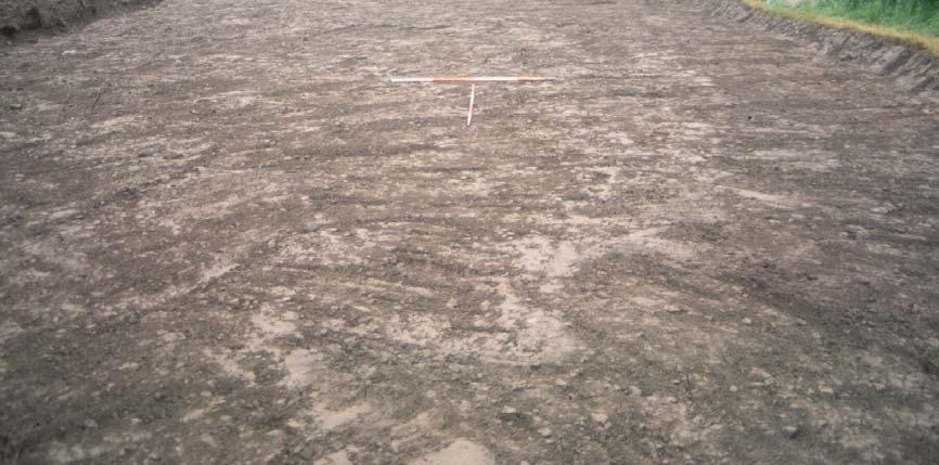
15 Plate 1: Topsoil strip facing south Plate 2: Topsoil strip facing north
Archaeological Watching Brief
 Barrack Block Drainage Hampton Court Palace Archaeological Watching Brief Report May 2012 Client: Historic Royal Palces Issue No: 1 OA Job No: 5329 NGR: TQ 15485 168587 Archaeological Watching Brief Archaeological
Archaeological Evaluation and Assessment of Land at Kent Cottage, 19 Chapel Street, Hythe, Kent
 Archaeological Evaluation and Assessment of Land at Kent Cottage, 19 Chapel Street, Hythe, Kent Planning Application Y13/0463/SH Date of Report: 29/04/2015 Report for Marc Carney SWAT. ARCHAEOLOGY Swale
MILLER BRIDGE, KENDAL, CUMBRIA
 MILLER BRIDGE, KENDAL, CUMBRIA Archaeological Watching Brief: Supplementary Report Oxford Archaeology North February 2010 Balfour Beatty Issue No: 2009-10/1006 OAN Job No: L10133 NGR: SD 5175 9269 Miller
Ivol Buildings, Woodcote Road, South Stoke, Oxfordshire
 Ivol Buildings, Woodcote Road, South Stoke, Oxfordshire An Archaeological Watching Brief For Christ Church, Oxford by Pamela Jenkins Thames Valley Archaeological Services Ltd Site Code IBSS 04/03 March
Archaeological Evaluation and Assessment of Land at Minnis Beeches, Canterbury Road, Swingfield, Dover, Kent
 Archaeological Evaluation and Assessment of Land at Minnis Beeches, Canterbury Road, Swingfield, Dover, Kent NGR: TQ 6307 1545 Site Code: MB-EV-10 (Planning Consent Y10/0311/SH) Report for Thorndene Ltd.
Chitty Farmhouse Extension, Wall Lane, Silchester, Hampshire
 Chitty Farmhouse Extension, Wall Lane, Silchester, Hampshire An Archaeological Watching Brief For In Touch by Andrew Mundin Thames Valley Archaeological Services Ltd Site Code CFS 08/52 May 2008 Summary
Northbury Farm, Castle End Road, Ruscombe, Berkshire
 Northbury Farm, Castle End Road, Ruscombe, Berkshire An Archaeological Watching Brief For Sir Colin and Lady Southgate by Danielle Milbank Thames Valley Archaeological Services Ltd Site Code NFR 07/120
Glue Pot Farm, Edwards Lane, Bramfield, Suffolk. BMF 024
 Glue Pot Farm, Edwards Lane, Bramfield, Suffolk. BMF 024 Archaeological Evaluation Report SCCAS Report No. 2013/107 Client: Keith Frost Architectural Design Services Author: Linzi Everett August 2013 SCCAS
Centre for Archaeological Fieldwork Evaluation/Monitoring Report No Monitoring Report No. 201
 Monitoring Report No. 201 Land adjacent to 58 Drumreagh Road Drumreagh Ballygowan Co. Down LICENCE NO.: AE/10/91E BRIAN SLOAN 1 Site Specific Information Site Name: Land adjacent to 58 Drumreagh Road,
ARCHAEOLOGICAL EVALUATION AT THE FORMER WATTON GARDEN CENTRE, NORWICH ROAD, WATTON, NORFOLK OCTOBER 2003 (Accession number WAT)
") NORTHAMPTONSHIRE ARCHAEOLOGY NORTHAMPTONSHIRE COUNTY COUNCIL NOVEMBER 2003 (Planning Application No: 3PL/1997/048/0 ARCHAEOLOGICAL EVALUATION AT THE FORMER WATTON GARDEN CENTRE, NORWICH ROAD, WATTON, NORFOLK
NORTHAMPTONSHIRE ARCHAEOLOGY NORTHAMPTONSHIRE COUNTY COUNCIL NOVEMBER 2003 (Planning Application No: 3PL/1997/048/0 ARCHAEOLOGICAL EVALUATION AT THE FORMER WATTON GARDEN CENTRE, NORWICH ROAD, WATTON, NORFOLK
Meales Farm, Sulhamstead, West Berkshire
 Meales Farm, Sulhamstead, West Berkshire An Archaeological Watching Brief For Mr. Robert Astor by Steve Ford Thames Valley Archaeological Services Ltd Site Code CHH02/29 May 2002 Summary Site name: Meales
Archaeological monitoring at Clintons, Bury Green, Little Hadham, Hertfordshire April 2008
 Archaeological monitoring at Clintons, Bury Green, Little Hadham, Hertfordshire April 2008 report prepared by Ben Holloway on behalf of Charles Britton Equestrian Construction CAT project ref.: 08/3b NGR:
Merrowdene, Earleydene, Sunninghill, Berkshire
 Merrowdene, Earleydene, Sunninghill, Berkshire An Archaeological Watching Brief For Mr and Mrs Jackson by Andy Taylor Thames Valley Archaeological Services Ltd Site Code MES 05/88 January 2006 Summary
New horse training area, Manor Farm, Great Kimble, Buckinghamshire
 New horse training area, Manor Farm, Great Kimble, Buckinghamshire An Archaeological Watching Brief For Redwing Structures (Marlow) Limited by Andy Taylor Thames Valley Archaeological Services Ltd Site
Garage Site, Foots Cray High Street, Sidcup, Kent, London Borough of Bexley
 Garage Site, Foots Cray High Street, Sidcup, Kent, London Borough of Bexley An Archaeological Evaluation for Mizen Design Build by Andy Taylor Thames Valley Archaeological Services Ltd FOC 07 September
Bridge House, Ham Island, Old Windsor, Berkshire
 Bridge House, Ham Island, Old Windsor, Berkshire An Archaeological Watching Brief for Mr A Chadwick by Alan Ford Thames Valley Archaeological Services Site Code BHHI98/55 August 1998 Bridge House, Ham
Land at Downsview Avenue, Storrington, West Sussex
 Land at Downsview Avenue, Storrington, West Sussex An Archaeological Evaluation for Bellwinch Homes Limited by Andy Taylor Thames Valley Archaeological Services Ltd Site Code DAS 04/21 March 2004 Summary
Monitoring Report No. 166
 Monitoring Report No. 166 No. 2a Loughadian Road Poyntzpass County Down AE/08/189 Nick Beer Site Specific Information Site Address: 2a Loughadian Road, Poyntzpass. Townland: Loughadian SMR No.: DOW 033:034
Monitoring of invasive groundworks ahead of the installation of a septic tank at 16a, 16b and 16c Donegore Hill Muckamore County Antrim
 Monitoring Report No. 177 Monitoring of invasive groundworks ahead of the installation of a septic tank at 16a, 16b and 16c Donegore Hill Muckamore County Antrim LICENCE NO.: AE/09/48 Brian Sloan 1 Site
Appletree, Thames Street, Sonning Berkshire
 Appletree, Thames Street, Sonning Berkshire An Archaeological Watching Brief for Mr and Mrs A Popham by Sian Anthony Thames Valley Archaeological Services Ltd Site Code ATS 02/83 October 2002 Summary Site
An Archaeological Evaluation at Granta Cottages, Newmarket Road, Great Chesterford, Essex. August 2015
 An Archaeological Evaluation at Granta Cottages, Newmarket Road, Great Chesterford, Essex August 2015 by Pip Parmenter and Ben Holloway on behalf of Mr G Elmer and Mrs L King CAT project ref.: 15/06a NGR:
Archaeological Monitoring of Land at 29 Royal Pier Road, Gravesend, Kent
 Archaeological Monitoring of Land at 29 Royal Pier Road, Gravesend, Kent Site Code ROY/WB/15 Report for Dr Maxted Date of report 06/10/2015 SWAT ARCHAEOLOGY Swale and Thames Archaeological Survey Company
Land adjacent to Dingle Dock, Front Street, East Garston
 Land adjacent to Dingle Dock, Front Street, East Garston An Archaeological Watching Brief for Dr J Davies by Jo Pine Thames Valley Archaeological Services Site Code DEG99/82 January 2000 Summary Site name:
Archaeological Investigation in advance of Development at 2 Palace Cottages, Charing Palace, Charing, Kent
 Archaeological Investigation in advance of Development at 2 Palace Cottages, Charing Palace, Charing, Kent Site Code CHAR-EV-14 NGR 95412 49439 Date of Report 18/12/2014 Swale and Thames Archaeological
MONITORING REPORT: No. 283
 MONITORING REPORT: No. 283 Dunluce Castle Visitor Centre Option Site D Magheracross Co. Antrim AE/14/109E Dermot Redmond List of Contents Site Specific Information 1 Account of the Monitoring 2 Discussion
Pinnocks Wood Equestrian Centre, Burchett s Green, Maidenhead, Berkshire
 Pinnocks Wood Equestrian Centre, Burchett s Green, Maidenhead, Berkshire An Archaeological Watching Brief For Mr David Eyles by Andrew Mundin Thames Valley Archaeological Services Ltd Site Code POB 08/69
ARCHAEOLOGICAL S E R V I C E S. Manor Farm, Launton, Bicester, Oxfordshire. Archaeological Watching Brief. by Aiji Castle. Site Code: LBO13/220
 T H A M E S V A L L E Y ARCHAEOLOGICAL S E R V I C E S Manor Farm, Launton, Bicester, Oxfordshire Archaeological Watching Brief by Aiji Castle Site Code: LBO13/220 (SP 6035 2285) Manor Farm, Launton, Bicester,
Ashton Hall Garden Centre, Ashton Hall, Ashton with Stodday, Lancashire
 Ashton Hall Garden Centre, Ashton Hall, Ashton with Stodday, Lancashire Archaeological Watching Brief Oxford Archaeology North January 2005 John Moore and Partners Architects Ltd Issue No: 2004-05/328
Archaeological evaluation at Willowdene, Chelmsford Road, Felsted, Essex
 Archaeological evaluation at Willowdene, Chelmsford Road, Felsted, Essex August 2013 report prepared by Ben Holloway on behalf of Mr Anthony McGurren Planning reference: UTT/13/0235 CAT project ref.: 13/07g
Archaeological evaluation at Stables, Hatch Farm, Fen Lane, Bulphan, Essex, RM14 3RL
 Archaeological evaluation at Stables, Hatch Farm, Fen Lane, Bulphan, Essex, RM14 3RL November-December 2016 by Laura Pooley figures by Ben Holloway and Emma Holloway fieldwork by Ben Holloway and Alec
Windsor Berkshire. Archaeological Watching Brief. King Edward VII Car Park Extension. Archaeological Watching Brief Report
 King Edward VII Car Park Extension Windsor Berkshire Archaeological Watching Brief Report March 202 Client: Royal Borough of Windsor and Maidenhead Issue No: OA Job No: 5242 NGR: SU 972 779 Archaeological
Archaeological evaluation: land to the rear of Clare Road, Braintree, Essex
 Archaeological evaluation: land to the rear of 41-45 Clare Road, Braintree, Essex March 2014 commissioned by Mr Mark Plummer report prepared by Ben Holloway and Howard Brooks Planning reference: 13/000585/FUL,
Evaluation/monitoring Report No. 241 KING S CASTLE NURSING HOME ARDGLASS CO. DOWN AE/12/19 SARAH GORMLEY
 Evaluation/monitoring Report No. 241 KING S CASTLE NURSING HOME ARDGLASS CO. DOWN AE/12/19 SARAH GORMLEY 1 Site Specific Information Site Name: Townland: King s Castle Ardglass SMR No. : DOW 045:024 Status:
Old Town Hall, Market Place, Faringdon, Oxfordshire
 Old Town Hall, Market Place, Faringdon, Oxfordshire Building Recording and Archaeological Watching Brief for Great Faringdon War Memorial Trust by Jamie Preston and Steve Ford Thames Valley Archaeological
Archaeological trial-trenching evaluation: New Hall School, The Avenue, Boreham, Essex. July 2015
 Archaeological trial-trenching evaluation: New Hall School, The Avenue, Boreham, Essex report prepared by Ben Holloway on behalf of New Hall School Planning reference: 14/01846/FUL CAT project ref.: 15/04i
6A St John s Road, Wallingford Oxfordshire
 6A St John s Road, Wallingford Oxfordshire An Archaeological Evaluation Stage 2 for Spearcliff Estates Ltd by Steve Ford Thames Valley Archaeological Services Ltd Site SJW03/116 January 2004 Summary Site
Archaeological Watching Brief Report
 New Playing Fields and Athletics Track Stowe School Buckinghamshire Archaeological Watching Brief o a July 2009 client logo Client: Stowe School Issue N o : 1 OA Job N o : 4167 NGR: SP 679 380 Archaeological
ARCHAEOLOGICAL S E R V I C E S. Becks, Park Lane, North Newington, Banbury, Oxfordshire. Archaeological Watching Brief.
 T H A M E S V A L L E Y ARCHAEOLOGICAL S E R V I C E S Becks, Park Lane, North Newington, Banbury, Oxfordshire Archaeological Watching Brief by Andy Mundin Site Code: BPN16/105 (SP 4207 3978) Becks, Park
Archaeological Watching Brief
 University Botanic Gardens High Street Oxford Archaeological Watching Brief Report January 2012 Client: Anthony Meek Issue No: 1 OA Job No: 4691 NGR: Centred on SP 5202 0607 Archaeological Watching Brief
New Media Building, Goldsmiths College, New Cross, London Borough of Lewisham
 New Media Building, Goldsmiths College, New Cross, London Borough of Lewisham An Archaeological Evaluation for Willmott Dixon Construction by Andy Taylor Thames Valley Archaeological Services Ltd Site
Archaeological evaluation at Redbank, Bury Water Lane, Newport, Essex, CB11 3TZ
 Archaeological evaluation at Redbank, Bury Water Lane, Newport, Essex, CB11 3TZ March 2017 by Laura Pooley figures by Ben Holloway and Emma Holloway fieldwork by Ben Holloway with Harvey Furniss and Elliott
MONITORING REPORT: No. 276
 MONITORING REPORT: No. 276 Between 51 and 53 Castor Bay Road Lurgan Co. Armagh AE/13/214 Dermot Redmond Site Specific Information Site Name: Between 51 and 53 Castor Bay Road, Lurgan, Co. Armagh Townland:
Archaeological evaluation on land at Mersea Fleet Way, Chelmer Road, Braintree, Essex, CM7 3PZ
 Archaeological evaluation on land at Mersea Fleet Way, Chelmer Road, Braintree, Essex, CM7 3PZ by Laura Pooley figures by Ben Holloway and Emma Holloway fieldwork by Ben Holloway, Robin Mathieson, Nigel
Archaeological Evaluation and Assessment of Land at the Duke of Kent site, Staple Street, Faversham, Kent September 2011
 Archaeological Evaluation and Assessment of Land at the Duke of Kent site, Staple Street, Faversham, Kent September 2011 SWAT. Archaeology Swale and Thames Archaeological Survey Company School Farm Oast,
MONITORING REPORT: No. 289
 MONITORING REPORT: No. 289 21 Ballynarrig Road Ballydarrog Co. Derry AE/14/213E Dermot Redmond Site Specific Information Site Name: 21 Ballynarrig Road, Limavady Townland: Ballydarrog SMR No. : LDY 016:004
Centre for Archaeological Fieldwork, School of Archaeology and Palaeoecology, Queen s University Belfast.
 Centre for Archaeological Fieldwork, School of Archaeology and Palaeoecology, Queen s University Belfast. Monitoring Report No. 04 Duneight Motte and Bailey, May 2004. On behalf of Monitoring Report: Duneight
Evaluation/Monitoring Report No. 243
 60m NORTH OF 64 BALLYGROOBANY ROAD BALLYNAHINCH RICHHILL COUNTY ARMAGH LICENCE NO.: AE/12/91E NAOMI CARVER 1 Site Specific Information Site Name: site 60m north of 64 Ballygroobany Road, Ballynahinch,
Archaeological Watching Brief
 Upper Car Park Service Trench Hampton Court Palace Archaeological Watching Brief Report July 2013 Client: Historic Royal Palaces Issue No: 1 OA Job No: 5292 NGR: TQ 155 686 Archaeological Watching Brief
ARCHAEOLOGICAL S E R V I C E S. Hurley Manor, High Street, Hurley, Berkshire. Archaeological Evaluation. by James McNicoll-Norbury
 T H A M E S V A L L E Y ARCHAEOLOGICAL S E R V I C E S Hurley Manor, High Street, Hurley, Berkshire Archaeological Evaluation by James McNicoll-Norbury Site Code: HMH14/51 (SU 8252 8378) Hurley Manor,
Archaeological monitoring and recording at 24 St Peter's Road, West Mersea, Essex, CO5 8LJ
 Archaeological monitoring and recording at 24 St Peter's Road, West Mersea, Essex, CO5 8LJ April 2017 by Dr Elliott Hicks figures by S Carter fieldwork by Adam Wightman on behalf of Brett Lord NGR: TM
Newcombe House & Kensington Church Street
 Newcombe House & Kensington Church Street Archaeological Evaluation September 2017 Summary Site name: Newcombe House, Kensington Church Street, Notting Hill, London Grid reference: TQ 25318 80372 Site
Historic England Advice Report 26 August 2016
 Case Name: Kingsland Castle Case Number: 1435892 Background Historic England has been asked to review the scheduling for Kingsland Castle. The land on which the monument lies is understood to be for sale.
New Swimming Pool,West Meon House, West Meon, Hampshire
 New Swimming Pool,West Meon House, West Meon, Hampshire An Archaeological watching brief and building recording for Mr and Mrs Younger by Danielle Milbank Thames Valley Archaeological Services Ltd Site
CHESHIRE HISTORIC TOWNS SURVEY
 CHESHIRE HISTORIC TOWNS SURVEY Frodsham Archaeological Strategy 2003 CHESHIRE HISTORIC TOWNS SURVEY Frodsham Archaeological Strategy 2003 Environmental Planning Cheshire County Council Backford Hall Backford
Archaeological evaluation on land at Unit 1, Waltham Hall, Bambers Green Road, Takeley, Essex, CM22 6PF
 Archaeological evaluation on land at Unit 1, Waltham Hall, Bambers Green Road, Takeley, Essex, CM22 6PF by Laura Pooley figures by Ben Holloway and Emma Holloway fieldwork by Ben Holloway with Jane Roberts
Monitoring Report No. 168
 Monitoring Report No. 168 Loughgall Presbyterian Church Cloven Eden Loughgall County Armagh AE/08/203 Nick Beer Site Specific Information Site Address: Loughgall Presbyterian Church, 100 Cloven Eden Road,
Archaeological evaluation at New Hall School, The Avenue, Boreham, Chelmsford, Essex, CM3 3HS
 Archaeological evaluation at New Hall School, The Avenue, Boreham, Chelmsford, Essex, CM3 3HS December 2016 by Laura Pooley with contributions by Stephen Benfield figures by Ben Holloway and Emma Holloway
Archaeological monitoring and recording at 20 St Peter's Road, West Mersea, Essex, CO5 8LJ
 Archaeological monitoring and recording at 20 St Peter's Road, West Mersea, Essex, CO5 8LJ November 2016 by Laura Pooley figures by Ben Holloway and Emma Holloway fieldwork by Ben Holloway on behalf of
2 Hardman Boulevard, Spinningfields, Manchester
 2 Hardman Boulevard, Spinningfields, Manchester Archaeological Investigation Oxford Archaeology North September 2014 Allied London Properties Ltd Application No: 103505/FO/2013/C1 Issue No: 2014-15/1535
Archaeological monitoring and recording at 26 Beaver Close, Colchester, Essex, CO3 9DZ
 Archaeological monitoring and recording at 26 Beaver Close, Colchester, Essex, CO3 9DZ May 2017 by Adam Tuffey and Laura Pooley figures by Sarah Carter, Chris Lister and Adam Tuffey fieldwork by Alec Wade
Elm Park, Station Road, Ardleigh, Essex, CO7 7RT: archaeological watching brief on installation of new water pipe
 Elm Park, Station Road, Ardleigh, Essex, CO7 7RT: archaeological watching brief on installation of new water pipe November 2015 report prepared by Howard Brooks BA FSA MCIfA on behalf of Partnerships in
Downton Manor, Downton, near Lymington, Hampshire
 Downton Manor, Downton, near Lymington, Hampshire An Archaeological Evaluation for New Milton Sand and Gravel by Sian Anthony Thames Valley Archaeological Services Ltd Site Code DMD03/20 May 2003 Summary
A Research Framework for the Archaeology of Wales Version 01, Final Paper Neolithic and Earlier Bronze Age
 NEOLITHIC AND EARLIER BRONZE AGE Introduction The introduction of farming around 4000 BC had a dramatic impact on the landscape of Wales and fundamentally changed they ways in which people lived and interacted.
PROPOSED DEVELOPMENT AT BRITANNIA PARK, BANGOR
 PROPOSED DEVELOPMENT AT BRITANNIA PARK, BANGOR ARCHAEOLOGICAL MITIGATION WORK Report No. 446 [08] [04] [06] [08] [06] [04] Prepared for Watkins Jones Construction March 2002 By J. Kenney Ymddiriedolaeth
What is fieldwalking?
 Cambridge Archaeology Field Group May 2012 What is fieldwalking? Archaeological fieldwalking (or Surface Artefact Collection as it is sometimes known) is the systematic recovery and recording of artefacts
ARCHAEOLOGICAL S E R V I C E S. Land north of Orchard Close, Hallow, Worcestershire. Archaeological Evaluation. by Kyle Beaverstock
 T H A M E S V A L L E Y ARCHAEOLOGICAL S E R V I C E S Land north of Orchard Close, Hallow, Worcestershire Archaeological Evaluation by Kyle Beaverstock Site Code: OCW15/224 (SO 8285 5848) Land north of
LANDSCAPE CHARACTER ASSESSMENT
 THE COUNTY DURHAM LANDSCAPE CHARACTER ASSESSMENT FOREWORD The landscape of County Durham is one of great contrast and diversity. From the North Pennines in the west to the Durham Coast in the east it contains
EVALUATION REPORT No. 300
 EVALUATION REPORT No. 300 Southwest of 2A Cloughey Road, Portaferry, Co. Down Licence No.: AE/135/85E Sapphire Mussen Report Date: 14 th May 2015 Site Specific Information Site Name: [Southwest of 2a]
Proposed Retirement Village Cole Green Way, Hertford. Archaeology Statement
 RETIREMENT LIVING MADE BETTER Proposed Retirement Village Cole Green Way, Hertford Archaeology Statement Woodlands Retirement Village RETIREMENT LIVING MADE BETTER Retirement Living Made Better Archaeology
An archaeological evaluation on land rear of 45 High Street (the Star Inn), Ingatestone, Essex April 2009
, Ingatestone, Essex April 2009") An archaeological evaluation on land rear of 45 High Street (the Star Inn), Ingatestone, Essex April 2009 report prepared by Ben Holloway and Howard Brooks commissioned on behalf of clients by Andrew Stevenson
An archaeological evaluation on land rear of 45 High Street (the Star Inn), Ingatestone, Essex April 2009 report prepared by Ben Holloway and Howard Brooks commissioned on behalf of clients by Andrew Stevenson
National Character Area 70 Melbourne Parklands
 Summary The are a landscape of rolling farmland, parkland and woodland on the northern flanks of the ridge between Burton upon Trent and Swadlincote. The land slopes down to the River Trent, which borders
Useful Studio 1st Floor, The Clove Building 4 Maguire Street, Butler s Wharf London SE1 2NQ
 Ms M Barlow Useful Studio 1st Floor, The Clove Building 4 Maguire Street, Butler s Wharf London SE1 2NQ Our ref: PL00049085 By email: michelle.b@usefulstudio.co.uk 12 th December 2016 Dear Ms Barlow, Re:
Appraisal of proposed alterations to the boundary of Helmsley Conservation Area
 Appraisal of proposed alterations to the boundary of Helmsley Conservation Area Elmslac Road: Elmslac Road was constructed in the early 1950s in two or three stages by the Helmsley Rural District Council.
Examination of South Cambridgeshire Local Plan
 Matter SC6A - Policy SS/5 Waterbeach New Town Historic England( formerly English Heritage) 874 Rep Nos 59748, 60250, 60253 Examination of South Cambridgeshire Local Plan Historic England, Hearing Statement
Archaeological Monitoring of Land to the rear of The Ridges, Valley Drive, Gravesend, Kent
 Archaeological Monitoring of Land to the rear of The Ridges, Valley Drive, Gravesend, Kent NGR: 566215 170479 Site Code RIDGE/WB/14 Report for Mr Sall Date of report 27/03/2014 SWAT ARCHAEOLOGY Swale and
Archaeological monitoring and recording: 20 Irvine Road, Colchester, Essex, CO3 0TR. July 2015
 Archaeological monitoring and recording: 20 Irvine Road, Colchester, Essex, CO3 0TR July 2015 by Pip Parmenter and Chris Lister on behalf of Ms Claire Murphy CAT project ref.: 15/03m NGR: TL 9819 2426
Strip Enclosure. Summary of Dominant Character
 Strip Enclosure Summary of Dominant Character This zone is characterised by long thin curving fields, sometimes all running in the same direction and sometimes forming a patchwork pattern across the landscape.
Gryme s Dyke, Stanway Green
 Gryme s Dyke, Stanway Green A short assessment of the archaeological impact of contractor s groundworks at the southern end of the Gryme s Dyke Middle earthwork February 2000 Archive report on behalf of
Land South-West of Mill Co age, Gidding Road, Sawtry, Cambridgeshire Evalua on Report
 Land South-West of Mill Coage, Gidding Road, Sawtry, Cambridgeshire Evaluaon Report August 2017 Client: CgMs Consulng Issue No: 1 OA East Report No: 2080 NGR: TL 1623 8329 Oxford Archaeology Ltd i 3 August
T H A M E S V A L L E Y S E R V I C E S. Flood Compensation Area, Riverside Park, Wallingford, Oxfordshire. Archaeological Watching Brief
 T H A M E S V A L L E Y ARCHAEOLOGICAL S E R V I C E S Flood Compensation Area, Riverside Park, Wallingford, Oxfordshire Archaeological Watching Brief by Jacqueline Pitt Site Code: RPW10/72 (SU 6112 8934)
Malden Green Farm, Worcester Park, Surrey, Royal Borough of Kingston
 Malden Green Farm, Worcester Park, Surrey, Royal Borough of Kingston An Archaeological Evaluation and Desk-Based Assessment for Bewley Homes by Steve Ford Thames Valley Archaeological Services Site Code
High Speed Rail (London- West Midlands)
") High Speed Rail (London- West Midlands) Draft Environmental Minimum Requirements Annex 3: Draft Heritage Memorandum November 2013 ESA 4.4 High Speed Rail (London- West Midlands) Draft Environmental Minimum
High Speed Rail (London- West Midlands) Draft Environmental Minimum Requirements Annex 3: Draft Heritage Memorandum November 2013 ESA 4.4 High Speed Rail (London- West Midlands) Draft Environmental Minimum
Archaeology and Planning in Greater London. A Charter for the Greater London Archaeology Advisory Service
 Archaeology and Planning in Greater London A Charter for the Greater London Archaeology Advisory Service THE PURPOSE OF THE CHARTER This Charter sets out how English Heritage will provide archaeological
Archaeological trial-trenching evaluation: Peldon Village Hall, Church Road, Peldon, Essex, CO5 7PT
 Archaeological trial-trenching evaluation: Peldon Village Hall, Church Road, Peldon, Essex, CO5 7PT December 2015 report prepared by Ben Holloway and Howard Brooks on behalf of Peldon Parish Council Planning
Barnes Hospital, Cheadle, Stockport,
 Barnes Hospital, Cheadle, Stockport, Greater Manchester Archaeological Evaluation Oxford Archaeology North September 2015 Reis Construct Ltd Issue No: 2015-16/1682 OA North Job No: L10909 NGR: 385232 388955
Landscape Guidelines. Landscape type: Valley Pasture Character areas: Frome Valley Pasture Stour Valley Pasture. Landscape change
 Landscape type: Valley Pasture Character areas: Frome Valley Pasture Stour Valley Pasture The valley pasture landscape type is found along the lower reaches of the Stour and Frome, formed from alluvial
Archaeological monitoring and recording at 54 Wellesley Road, Colchester, Essex, CO3 3HF
 Archaeological monitoring and recording at 54 Wellesley Road, Colchester, Essex, CO3 3HF October 2015 by Laura Pooley on behalf of Mr Wright Planning reference: 145409 CAT project ref.: 14/12d NGR: TL
Public Consultation. Land at Monks Farm, North Grove. Welcome
 Welcome Welcome to our public exhibition for development on Land at Monks Farm, orth Grove. Gallagher Estates and Gleeson Strategic Land are preparing an outline planning application for new homes, open
How we find the sites
 How we find the sites Many of the archaeological sites mapped by aerial archaeologists have been levelled by ploughing and are identified from the photos as cropmarks or soilmarks. Archaeological sites
EDEN VALLEY, CUMBRIA. COMMUNITY ARCHAEOLOGY PROJECT BRIEF (PHASE 1) September Extract from Jeffrey s 1770 Map of Westmorland
 September Extract from Jeffrey s 1770 Map of Westmorland") APPLEBY-IN-WESTMORLAND, EDEN VALLEY, CUMBRIA Extract from Jeffrey s 1770 Map of Westmorland COMMUNITY ARCHAEOLOGY PROJECT BRIEF (PHASE 1) September 2015 MARTIN RAILTON, BA (HONS) MA MIFA APPLEBY ARCHAEOLOGY
APPLEBY-IN-WESTMORLAND, EDEN VALLEY, CUMBRIA Extract from Jeffrey s 1770 Map of Westmorland COMMUNITY ARCHAEOLOGY PROJECT BRIEF (PHASE 1) September 2015 MARTIN RAILTON, BA (HONS) MA MIFA APPLEBY ARCHAEOLOGY
North East Region TYNE & WEAR 1 /315 (B ) NZ
 NZ") TYNE & WEAR Newcastle Upon Tyne 1 /315 (B.05.6311) NZ 28016514 138 FOSSWAY, WALKER An Archaeological Desk-Based Assessment for a Proposed Development at 138 Fossway, Walker GeoQuest Associates Consett
TYNE & WEAR Newcastle Upon Tyne 1 /315 (B.05.6311) NZ 28016514 138 FOSSWAY, WALKER An Archaeological Desk-Based Assessment for a Proposed Development at 138 Fossway, Walker GeoQuest Associates Consett
The Archaeology of North West England
 An Archaeological Research Framework for the North West Region Volume 1 Resource Assessment Edited by Mark Brennand with Gill Chitty (Consultant Editor) and Michael Nevell (Series Editor) and with John
25 Northgate Street, Bury St Edmunds BSE 443
 25 Northgate Street, Bury St Edmunds BSE 443 Archaeological Monitoring Report SCCAS Report No. 2014/065 Commissioned by: John Stebbings Author: Andrew Tester August 2014 Suffolk County Council Archaeological
XSW11, Plumstead Portal worksites, Interim Statement for NLBH. 1 Introduction Site Methodology and fieldwork objectives...4
 Contents 1 Introduction...4 2 Site Methodology and fieldwork objectives...4 2.1 NLBH Methodology... 4 2.2 NLBH Fieldwork Objectives... 5 3 Provisional Results...6 3.1 NLBH various features... 6 3.2 Shelter
Plots 1 & 2, Eves Orchard, Bures St Mary BSM 062
 Plots 1 & 2, Eves Orchard, Bures St Mary BSM 062 Archaeological Evaluation Report SCCAS Report No. 2014/014 Client: Persimmon Homes (Anglia) Ltd Author: J. A. Craven January 2014 Suffolk County Council
Archaeological monitoring and recording at Priory Street Car Park, Colchester, Essex, CO1 1QA
 Archaeological monitoring and recording at Priory Street Car Park, Colchester, Essex, CO1 1QA October-November 2016 by Laura Pooley figures by Chris Lister and Emma Holloway fieldwork by Sarah Carter,
Yorkshire Sculpture Park Historic Landscape Management Plan. Volume I. July 2010
 Yorkshire Sculpture Park Historic Landscape Management Plan Volume I July 2010 T: 01904 691630 www.landscapeagency.co.uk enquiries@landscapeagency.co.uk Contents 3 Volume I Historic Landscape Management
Oxford Green Belt Study. Summary of Final Report Prepared by LUC October 2015
 Oxford Green Belt Study Summary of Final Report Prepared by LUC October 2015 Project Title: Oxford Green Belt Study Client: Oxfordshire County Council Version Date Version Details Prepared by Checked by
Friends Meeting House, Broughton. Meeting House Lane, Little Broughton, Cockermouth, CA13 0YQ. National Grid Reference: NY
 Friends Meeting House, Broughton Meeting House Lane, Little Broughton, Cockermouth, CA13 0YQ National Grid Reference: NY 07832 31740 Statement of Significance The modest building has medium significance
HERITAGE POLICY...Safeguarding the Built Heritage. Conservation Plans. A Guide to the Preparation of Conservation Plans
 HERITAGE POLICY...Safeguarding the Built Heritage Conservation Plans A Guide to the Preparation of Conservation Plans 1 2 1.0 INTRODUCTION 1.1 Scotland has a diverse built heritage: ancient monuments and