Public Hearing. Preliminary Draft Development Plans (zoning plans) Dutch Quarter and Middle Region. June 28, 2016
|
|
|
- Marjorie Benson
- 5 years ago
- Views:
Transcription

1 Public Hearing Preliminary Draft Development Plans (zoning plans) Dutch Quarter and Middle Region June 28, 2016 Development plan SXM September 2012

2 Welcome by the initiator of this public hearing On behalf of Angel C. Meyers Minister of Public Housing, Spatial Planning, Environment and Infrastructure: We welcome you at this meeting to discuss the Preliminary Draft Development Plans: Dutch Quarter and Middle Region
3 Welcome by the hosts of this meeting Ministry of VROMI zoning team: Louis Brown: Secretary General Thijs Sommers: Project Leader Emmalexis Velasquez: PR officer Charlon Pompier: Policy Advisor Slide 3 of 54
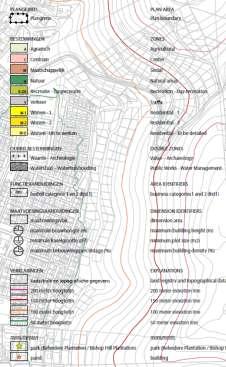
4 Agenda General explanation about the Development Plans Topics Preliminary Draft Development Plans: Mobility Business activities Residential and public facilities Agriculture Nature, landscape and water Cultural history and archeology General remarks and Preliminary Draft Maps Public Development Hearing plan Preliminary SXM September Draft Draft Development 2012 Plans Plans Dutch Cole Bay Quarter and and Billy Middle Folly- Cay Region Bay
5 Purpose of a Development / Zoning Plan Legal framework for possible future development To designate and/or reserve land for desired use To prevent undesired development To offer legal security to residents about future development Scope: It s not an Action Plan; it s a framework plan reserve space in terms of zoning with a scope of 10 years on district / neighborhood level Public Development Hearing plan Preliminary SXM September Draft Draft Development 2012 Plans Plans Dutch Cole Bay Quarter and and Billy Middle Folly- Cay Region Bay


6 Content of a development / zoning plan A Development Plans contains: A map with common zoning designations, such as Residential ; Regulations regarding both land use and building (height, density, etc.); Elucidation: what, why and how Public Development Hearing plan Preliminary SXM September Draft Draft Development 2012 Plans Plans Dutch Cole Bay Quarter and and Billy Middle Folly- Cay Region Bay


7 Relation to other plans / policies the Spatial Development Strategy (SDS) is a coherent and comprehensive vision for sustainable spatial development of SXM The countrywide SDS provides a basis/ context for the more detailed zoning plans on a district scale Tonight we will focus on the zoning plans, but also provide more context by highlighting policy proposals from the SDS High order national goals and priorities e.g. relevant legislation and National Development Plan Spatial Development Strategy: highest level of spatial planning Development plans/ zoning plans: land use and building regulations on a district scale More detailed (sectoral) policies and action plans for the implementation of concrete projects Public Development Hearing plan Preliminary SXM September Draft Draft Development 2012 Plans Plans Dutch Cole Bay Quarter and and Billy Middle Folly- Cay Region Bay
8 Process to follow for development plans 1 st public meeting: Points of Departure Points of Departure 2 nd public meeting Preliminary Draft Development Plan Public Hearing Draft Development Plan November 2012: 1 st public meeting, points of Departure (presentation on gov. website) August 2013: from starting points to development plan (presentation on gov. website) Tonight: Public Hearing Preliminary Draft Development Plans Public Review Advice from among others Committee of Experts and (final) decision making by Parliament Development Plan
9 Goal of this Public Hearing Public Hearing of the preliminary draft development plans as prescribed by the National Ordinance on Spatial Development Planning, popularly known as Zoning Ordinance (Article 4.1) Everyone can express their views and concerns regarding these preliminary draft development plans The outcome of this public hearing will be taken into account and the draft development plans will be put on public review for a period of 30 days accordingly One combined presentation about two separate preliminary draft development plans, namely Dutch Quarter and Middle Region
10 2ᶰᵈ public meeting recap Some of the issues discussed: Road network (Link 6) Development of Bethlehem and Belvedere estates Village centers for both areas Water management Public Development Hearing plan Preliminary SXM September Draft Draft Development 2012 Plans Plans Dutch Cole Bay Quarter and and Billy Middle Folly- Cay Region Bay
11 Preliminary Draft Development Plans Main topics: Mobility Business activities Residential and public facilities Agriculture Nature, landscape and water Cultural history and archeology
12 Preliminary Draft Development Plans Main topics: Mobility Business activities Residential and public facilities Agriculture Nature, landscape and water Cultural history and archeology Public Development Hearing plan Preliminary SXM September Draft Draft Development 2012 Plans Plans Dutch Cole Bay Quarter and and Billy Middle Folly- Cay Region Bay

13 Mobility Public Hearing Preliminary Draft Development Plan Simpson Bay, February 25, 2014 Slide of of 5554 Development Public Hearing plan Preliminary SXM September Draft 2012 Development Plans Dutch Quarter and Middle Region

14 Mobility Objectives in terms of zoning in order to improve mobility: Reserve space for a strategic connection from Dutch Quarter to Cul de Sac, Link 6 Improvement of secondary roads infrastructure Public Hearing Preliminary Draft Development Plan Simpson Bay, February 25, 2014 Slide of of 5554

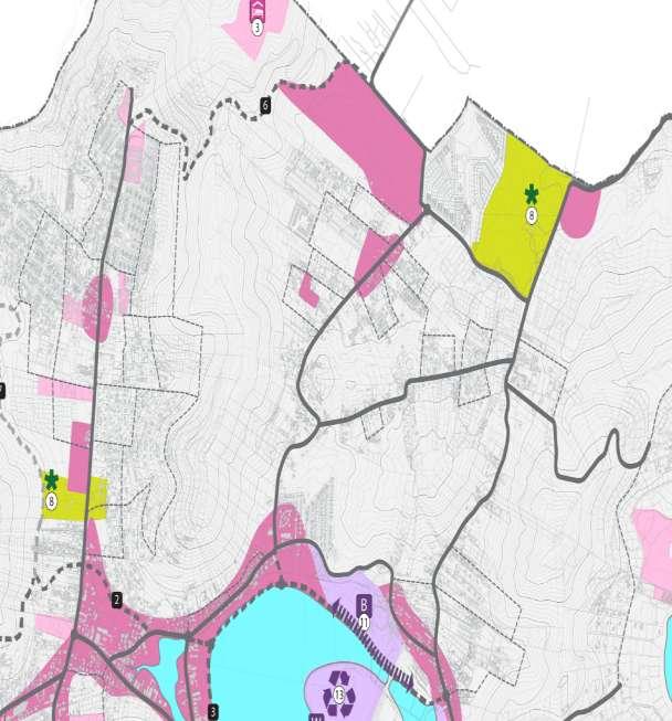
15 Mobility, Link 6 The eastern part, will lead from the Bethlehem Estate to the Waymouth Estate. This section consists of a new road The road connection continues over the hill, to LB Scott Road, along the existing Mildrum Road, which needs to be upgraded Public Hearing Preliminary Draft Development Plan Simpson Bay, February 25, 2014 Slide of of 5554 Development Public Hearing plan Preliminary SXM September Draft 2012 Development Plans Dutch Quarter and Middle Region

16 Mobility, Link 6 Traffic zoning designation for Link 6 in the development plan, with ample space reservation for further detailing of alignment Slide of of 5554

17 Mobility, secondary road network Improvement of secondary road network to create by- passes, for example upgrading of Madrid Road as alternative connection between Dutch Quarter and Middle Region Subject to further study and made possible within underlying zoning designations, so not directly indicated on the map. Identification of secondary road system, with possible extra connection between Dutch Quarter and Middle Region via Madrid Road. Slide of of 5554
18 Preliminary Draft Development Plans Main topics: Mobility Business activities Residential and public facilities Agriculture Nature, landscape and water Cultural history and archeology Public Hearing Preliminary Draft Development Plan Simpson Bay, February 25, 2014 Slide Slide 1823 of of 5554 Development Public Hearing plan Preliminary SXM September Draft Development 2012 Plans Dutch Quarter and Middle Region
19 Business activities
20 Business activities Objectives: Facilitate mixed (commercial/residential) use along sections of the main roads Reserve space for more significant commercial development at Bethlehem and Union Farm Locations Development of Belvedere will be addressed under cultural history and monuments


21 Business activities Mixed use of functions permitted by means of Center and Center- to be detailed zoning designation Small-scale business allowed along sections of the main roads by means of Business category 1 identifier
22 Business activities Development of Bethlehem Commercial node/ mixed use plan for Bethlehem Village at the border Main land-use designations on the map, such as Center, Residential and Mixed, which allows flexibility in detailing Proposed functions: retail, sport (cricket stadium), theatre, police station, school, residential, park, etc.
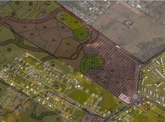
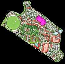

23 Business activities Development of Bethlehem, Village at the Border
24 Preliminary Draft Developments Main topics: Mobility Commercial Residential and public facilities Nature, landscape and water Cultural history and archeology Slide 2534 of of 5554

25 Residential and public facilities
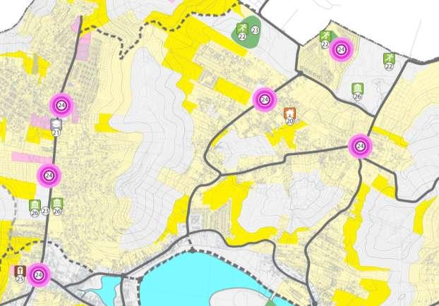
26 Residential and public facilities Objectives: Provide sufficient space in terms of zoning to cater for projected housing demand Maintain the mix of types of dwellings, while imposing building requirements for height, density and suchlike Facilitate village centers and other social / public functions
 Category 2: W -")
 Development plan SXM September")
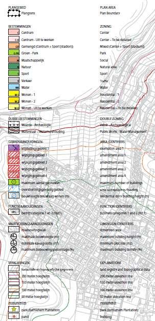
27 Residential Three different kind of residential zoning designations: Category 1: W -1: < 50m (existing residential areas) Category 2: W - 2: > 50m (existing residential areas) Category 3: W - U To be detailed (zoned for new residential development) Development plan SXM September 2012

28 Residential W-1 Residential-1 : lower lying areas (< 50 meter altitude) No minimum lot size Maximum building density of 40% Maximum building height of 10m.
 Maximum building height of 6,5m Construction of cistern is mandatory (3m² per")
29 Residential W-2 Residential-2 : higher areas (> 50 meter altitude) Minimum lot size and maximum building density based on elevation and slope of the area (translation of Hillside Policy) Maximum building height of 6,5m Construction of cistern is mandatory (3m² per bedroom)

30 Residential W-U Residential- to be detailed For large areas not yet built, without a planning permit, but that may be developed in the future Subdivision plan has to be made by the developer and to be approved by the Minister of VROMI based on the criteria of the Draft Development Plan (access, water management, etc.)
31 Residential Residential general regulations: all types of residential use (type of dwellings) are in principle allowed as long as they comply with building regulations; no commercial activities allowed except from home-based occupation such as architect or administration and small guesthouses, bed and breakfast; parking regulations: minimum of one parking space per dwelling plus one additional parking space for every two bedrooms existing rights such as irrevocable planning permits will be respected.


32 Residential Overview residential areas Dutch Quarter and Middle Region
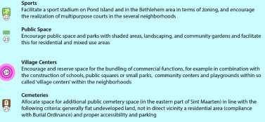
33 Residential, Village Centers Encourage so called village centers within the neighborhoods Stimulates social cohesion, the quality of life, and will contribute to limiting traffic movements Facilitated within Center and / or Social zoning designation

34 Residential, Village Centers Possible locations Village Center Dutch Quarter

35 Residential, Village Centers Possible locations Village Center Middle Region
36 Residential, other social / public facilities Other social / public functions within residential zoning include: Multi purposes sport courses (possible within residential zoning designation) Neighborhood parks and green spaces (Secondary) school possible within Bethlehem development Cemeteries are running out of space, demand for an additional location: possibly within Dutch Quarter or Middle Region, location yet to be determined in
37 Preliminary Draft Development Plans Main topics: Mobility Business activities Residential and public facilities Agriculture Nature, landscape and water Cultural history and archeology
 agriculture also for the temporary use of empty")
38 Agriculture Objective: facilitate and encourage (small scale) agriculture also for the temporary use of empty lots


39 Agriculture Agriculture in principle allowed within every zoning designation Exemption can be granted for livestock farming, under certain conditions, the farm must not disproportionately affect the residential and living environment of the adjacent lands
40 Preliminary Draft Development Plans Main topics: Mobility Business activities Residential and public faiclities Agriculture Nature, landscape and water Cultural history and archeology

41 Nature, landscape and water: nature and landscape
42 Nature, landscape and water: nature and landscape Objectives nature and landscape for Dutch Quarter and Middle Region zoning plans: Preservation of (higher) green hills Attention for stormwater water management, natural gutters and flood prone areas

43 Nature, landscape and water: nature and landscape Green hillsides: high scenic and ecological value, buffer for rainwater and prevention of erosion Therefore, preserve higher slopes of green hills as natural areas, also within the adjacent Development Plan HCA


44 Nature, landscape and water: water management Flooding is a transboundary issue Dutch and French Quarter Attention needed for stormwater management (e.g. water retention, flood proofing) French Quarter Dutch Quarter Flooding as a result of 2005 cloud brake, 150 mm in one hour (Unesco - IHE, 2010)


45 Nature, landscape and water: water management Storm water management plan for new developments: new development may not adversely affect lower lying area Attention for water retention and erosion control


46 Nature, landscape and water: water management Regulations for flood prone areas: minimum elevation of ground floor height (flood proof building) Protection of natural gutter by means of double zoning designation for Water management
47 Preliminary Draft Development Plans Main topics: Mobility Business activities Residential and public facilities Agriculture Nature, landscape and water Cultural history and archeology Development Public Hearing plan Preliminary SXM September Draft 2012 Development Plans Dutch Quarter and Middle Region
48 Cultural history and archeology Objectives for both the Spatial Development Strategy and Dutch Quarter and Middle Region zoning plans: Protecting potentially present artifacts by conducting research prior to development of area with a high archeological value Enable preservation driven development of monuments in terms of zoning (in this case: Belvedere, Bethlehem and Union Farm)


49 Cultural history and archeology: monuments Designated monuments are protected via the Monument Ordinance and marked on the map of the Development Plan (awareness function) Bethlehem, Belvedere and the Union Farm plantation house are designated monuments within the plan areas

50 Cultural history and archeology: monuments Preservation driven development of monuments Development plans make new potential use of monuments possible which is required to maintain the monuments Example: planned Historical Park and possible Golf course in Belvedere

51 Cultural history and archeology: monuments Historical Theme Park Belvedere; also serves as an addition / diversification of the tourism product
 specialist, field research and preservation of artifacts might be required in some occasions; the Minister may entirely or partly remove the")
52 Cultural history and archeology: archeological value Double zoning with Value- Archeological : for areas with a expected high archeological value, development might only be allowed if the archeological value is not at stake; evaluation by (VROMI) specialist, field research and preservation of artifacts might be required in some occasions; the Minister may entirely or partly remove the Value- Archeological zoning from the map if, on the basis of archaeological investigation, no archeological values were found to be present.
53 Preliminary Draft Development Plans Main topics: Mobility Business activities Residential and public facilities Agriculture Nature, landscape and water Cultural history and archeology General remarks and Preliminary Draft Maps
54 General remark: existing situations What if existing situation (building and/or usage, or building permit) is different from the Development Plan? -> Situation can be maintained, if: it was legally put there, and; it was already there before publication of Draft Development plan

55 Slide 51 of 54
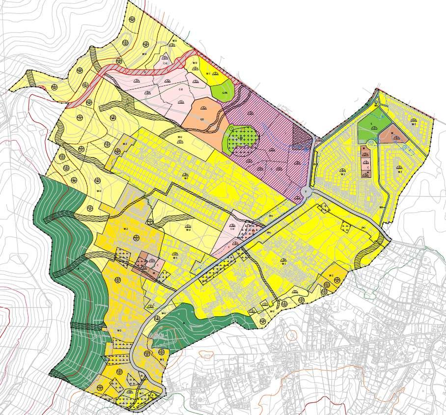
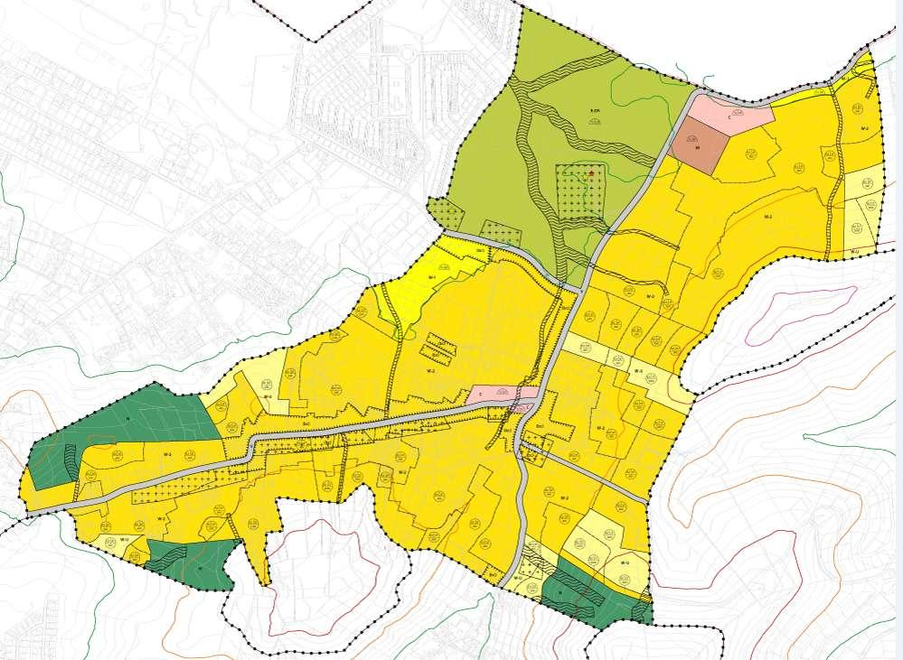
56 Preliminary Draft Map Dutch Quarter
57 Preliminary Draft Map Middle Region
58 What is next? 1 st public meeting: Points of Departure Points of Departure 2 nd public meeting Preliminary Draft Development Plan Public Hearing Draft Development Plan Public Review Advice from among others Committee of Experts and (final) decision making by Parliament Development Plan Public Review of the Draft Development Plans. Everyone will be invited to review and submit their written comments/ objections to the Minister of VROMI Will be announced through the local news media shortly, stay tuned!
59 Thank you for your attention Questions, comments? This presentation will be uploaded to: > Ministry of Public Housing, Spatial Planning, Environment & Infrastructure > Zoning/ Development Plans
Town of Liberty, NY COMPREHENSIVE PLAN & ZONING UPDATES
 Town of Liberty, NY S Public Informational Meeting October 4, 2016 High School Auditorium Welcome Thank you for coming tonight. Agenda Part I Overview of Proposed Changes What is Being Prepared Anticipated
2035 General Plan Update and Belmont Village Specific Plan. Joint Study Session with the City Council and Planning Commission April 12, 2016
 2035 General Plan Update and Belmont Village Specific Plan Joint Study with the City Council and Planning Commission April 12, 2016 Agenda 1. Welcome and Introductions 2. General Plan Update Status of
Planning Proposal Toronto Road, Booragul. Amendment to Lake Macquarie Local Environmental Plan (LMLEP) 2014
 2014") Planning Proposal Toronto Road, Booragul Amendment to Lake Macquarie Local Environmental Plan (LMLEP) 2014 Local Government Area: Name of Draft LEP: Subject Land: Land Owner: Applicant: Folder Number:
Planning Proposal Toronto Road, Booragul Amendment to Lake Macquarie Local Environmental Plan (LMLEP) 2014 Local Government Area: Name of Draft LEP: Subject Land: Land Owner: Applicant: Folder Number:
14.5 HOPEFIELD: (REFER PLAN 39 AND PLAN 40)
") URBAN DYNAMICS WESTERN CAPE INC. 248 14.5 HOPEFIELD: (REFER PLAN 39 AND PLAN 40) FIGURE 83: LOCALITY - HOPEFIELD Within the context of the Saldanha Bay Municipal area, Hopefield, an historical agricultural
URBAN DYNAMICS WESTERN CAPE INC. 248 14.5 HOPEFIELD: (REFER PLAN 39 AND PLAN 40) FIGURE 83: LOCALITY - HOPEFIELD Within the context of the Saldanha Bay Municipal area, Hopefield, an historical agricultural
It Takes A Village.. Preserving Rural Character In Standish
 It Takes A Village.. Preserving Rural Character In Standish A Public Workshop Hosted by Conservation and Open Space Plan Committee & Standish Corner Village Implementation Committee June 12, 2008 Desired
Remi Mendoza City Planning Academy March 13, 2017
 Remi Mendoza City Planning Academy March 13, 2017 1 What is the General Plan? The 2030 General Plan 5-Year Update (2035 General Plan) Questions and Answers 2 Guidebook for development and growth Required
Lawrencetown Beach & Rainbow Haven Beach
 Lawrencetown Beach & Rainbow Haven Beach Public Engagement Session Wednesday, September 27 th, 2017 6:00pm 8:00pm Cole Harbour Place 51 Forest Hills Pkwy, Dartmouth Agenda Welcome & Introductions Overview
Guidelines for Planning Authorities and Part V of the Planning and Development Act 2000: December 2000
 Slide 1 Slide 2 Slide 3 Slide 4 As a planner in practice, whether within the Local Authority, private practice or An Bord Pleanala, due regard must be given to the guidance provided by the Department in
GATEWAY AREA STRUCTURE PLAN
 CHESTERMERE GATEWAY AREA STRUCTURE PLAN COMMUNITY OPEN HOUSE SEPTEMBER 22 nd, 2015 PLAN AREA ± 512 hectares (± 1,265 acres) GATEWAY LOCATION UNDEVELOPED LANDS PRESENT AGRICULTURAL USE REGIONAL LAND USE
1.0 Purpose of a Secondary Plan for the Masonville Transit Village
 Report to Planning and Environment Committee To: Chair and Members Planning & Environment Committee From: John M. Fleming Managing Director, Planning and City Planner Subject: Masonville Transit Village
PLANNED UNIT DEVELOPMENT & SUBDIVISION STAFF REPORT Date: May 18, 2017
 & PUD-0000102-2017 PLANNED UNIT DEVELOPMENT & SUBDIVISION STAFF REPORT Date: May 18, 2017 NAME SUBDIVISION NAME Dauphin Creek Estates Subdivision Dauphin Creek Estates Subdivision LOCATION CITY COUNCIL
ENVIRONMENTAL IMPACT ASSESSMENT
 ENVIRONMENTAL IMPACT ASSESSMENT NOTICE OF ENVIRONMENTAL IMPACT ASSESSMENT PROCESS FOR THE PROPOSED HAASENDAL DEVELOPMENT AND KUILS RIVER GOLF COURSE RE-DEVELOPMENT ON ERF 23580, ERF 23579, ERF 23582, ERF
Whitemarsh Comprehensive Plan Update: Housing & Land Use. Public Workshop #3: September 20, 2018
 Whitemarsh Comprehensive Plan Update: Housing & Land Use Public Workshop #3: September 20, 2018 Agenda Welcome Process Recap What We ve Heard The Plan Framework Review of Recommended Actions Land Use Housing
Shady Grove Sector Plan
 Montgomery Planning Area 2 Division 11/15/2018 Shady Grove Sector Plan Minor Master Plan Amendment Scope of Work Edit presentation title MM/DD/YYYY 1 Purpose for the Plan Amendment 1. Reevaluate/status
Perth and Kinross Council Development Management Committee 8 June Pre-Application Report by Development Quality Manager
 Perth and Kinross Council Development Management Committee 8 June 2016 5(3)(i) 16/259 Pre-Application Report by Development Quality Manager Residential development at St Martins Road, Land 120 metres West
City Council Special Meeting AGENDA ITEM NO. C.
 City Council Special Meeting AGENDA ITEM NO. C. DATE: 01/04/2019 TO: Honorable Mayor and City Council Members SUBJECT: Transit Villages Specific Plan project Study Session (Development Services Director
Vaughan Metropolitan Centre (VMC) Black Creek Renewal CLASS ENVIRONMENTAL ASSESSMENT
 Black Creek Renewal CLASS ENVIRONMENTAL ASSESSMENT") PUBLIC INFORMATION CENTRE Vaughan Metropolitan Centre (VMC) Black Creek Renewal Wednesday, May 10, 2017 6:00 p.m. to 8:00 p.m. Add photo Project Management, Environmental Assessment, Stormwater Management
PUBLIC INFORMATION CENTRE Vaughan Metropolitan Centre (VMC) Black Creek Renewal Wednesday, May 10, 2017 6:00 p.m. to 8:00 p.m. Add photo Project Management, Environmental Assessment, Stormwater Management
PRIORITIES COMMITTEE MEETING
 PRIORITIES COMMITTEE MEETING Meeting Date: October 28, 2014 Agenda Item #: 11.1 Mature Neighbourhood Strategy Phase 2 Report Purpose To provide the Priorities Committee with a progress update on the Mature
Planning Policy Wales (PPW) Draft Edition 10
 Draft Edition 10") Corporate slide master With guidelines for corporate presentations Planning Policy Wales (PPW) Draft Edition 10 Jon Fudge, Head of Planning Policy 16 th February 2018 Why have we reviewed PPW? Need to
Corporate slide master With guidelines for corporate presentations Planning Policy Wales (PPW) Draft Edition 10 Jon Fudge, Head of Planning Policy 16 th February 2018 Why have we reviewed PPW? Need to
S A C R A M E N T O C O U N T Y JACKSON HIGHWAY & GRANT LINE EAST VISIONING STUDY
 JACKSON HIGHWAY & GRANT LINE EAST S A C R A M E N T O C O U N T Y P L A N N I N G D E P A R T M E N T SUMMARY AND WORKBOOK November 19, 2008 History of the Visioning Study Sacramento County has two growth
SAN RAFAEL GENERAL PLAN 2040 INTRODUCTION AND OVERVIEW
 SAN RAFAEL GENERAL PLAN 2040 INTRODUCTION AND OVERVIEW Steering Committee Presentation February 14, 2018 Purpose of General Plan Guide land use and development decisions Coordinate transportation, infrastructure,
Scarborough Waterfront Project
 Scarborough Waterfront Project Public Information Centre #1 Environmental Assessment Terms of Reference September 10, 2014 Agenda Open House Presentation 7:00 to 7:30 pm Presentation 7:30 to 8:15 pm History
Living with World Heritage in Africa
 INTERNATIONAL CONFERENCE Living with World Heritage in Africa [26 26-29 September 2012] South Africa BACKGROUND DOCUMENT The Government of the Republic of South Africa, in collaboration with the African
Town of Cobourg Heritage Master Plan. Statutory Public Meeting
 Town of Cobourg Heritage Master Plan Statutory Public Meeting April 25 th 2016 Presentation Overview 1. Introduction 2. Project background and schedule overview 3. Review of strategic direction content
Newcourt Masterplan. November Exeter Local Development Framework
 Newcourt Masterplan November 2010 Exeter Local Development Framework Background The Exeter Core Strategy Proposed Submission sets out the vision, objectives and strategy for the development of Exeter up
HERITAGE ACTION PLAN. Towards a renewed Heritage Conservation Program. What is the Heritage Action Plan? Key areas of work. A Collaborative Approach
 HERITAGE ACTION PLAN Towards a renewed Heritage Conservation Program What is the Heritage Action Plan? The Heritage Action Plan (HAP) is a set of actions to update the City s Heritage Conservation Program
COMMISSION ACTION FORM
 ITEM #: 6 DATE: 09-06-17 COMMISSION ACTION FORM REQUEST: Introduction and Initial Review of Proposed Amendments to the Ames Urban Fringe Future Land Map for the North Growth Gap Area BACKGROUND INFORMATION:
WATERS EDGE AT DOBBS FERRY DRAFT ENVIRONMENTAL IMPACT STATEMENT VOLUME I
 WATERS EDGE AT DOBBS FERRY DRAFT ENVIRONMENTAL IMPACT STATEMENT VOLUME I Atilda, Fairlawn and Constance Avenues Village of Dobbs Ferry Town of Greenburgh Westchester County, New York Tax Lot Numbers Section
Asbury Chapel Subdivision Sketch Plan
 Asbury Chapel Subdivision Sketch Plan PART 1: PROJECT SUMMARY Applicant: NVR Inc. Project Size: +/- 76.13 acres Parcel Numbers: 02101112,02116101,02116112, 02116113 Current Zoning: Transitional Residential
Stafford County Strategic Plans
 Stafford County Strategic s Strategic Department Description Date Adopted Board of Supervisors Priorities Fiscal Responsibility Education Public Safety Infrastructure Economic Development Service Excellence
City of Lake Elmo Planning Commission Meeting Minutes of August 10, 2015
 City of Lake Elmo Planning Commission Meeting Minutes of August 10, 2015 Chairman Dodson called to order the meeting of the Lake Elmo Planning Commission at 7:00 p.m. COMMISSIONERS PRESENT: Dodson, Dorschner,
Introduction. Chapter 1. Purpose of the Comprehensive Plan Plan Organization Planning Process & Community Input 1-1
 Chapter 1 Introduction Lakewood 2025: Moving Forward Together Purpose of the Comprehensive Plan Plan Organization Planning Process & Community Input 1-1 Purpose of the Comprehensive Plan The Comprehensive
a) buildings, structures and artifacts of historical significance;
 buildings, structures and artifacts of historical significance;") 12.3.2. Definition Heritage Resources: There are two classes of heritage resources: monumental or landmark heritage that is considered to reflect exemplary architecture and style of a particular area or
12.3.2. Definition Heritage Resources: There are two classes of heritage resources: monumental or landmark heritage that is considered to reflect exemplary architecture and style of a particular area or
NEW REGIONAL OFFICIAL PLAN HIGH LEVEL PROCESS & FRAMEWORK
 NEW REGIONAL OFFICIAL PLAN HIGH LEVEL PROCESS & FRAMEWORK Why A New Official Plan Originally the role of Regionally Planning and content of Regional Official Plan (1970s) primarily focused on protecting
Public Consultation 23 January Peel Hall, Warrington Board 1. A message from Satnam... Site history...
 Board 1 A message from Satnam... Thank you for attending today s public consultation about proposals to develop a new residential neighbourhood at. The display boards show why the development is needed
Vancouver. Title of the Initiative. Initiative Duration. Submitted by. Comments by the Jury
 134 Vancouver Title of the Initiative Initiative Duration Submitted by Comments by the Jury Visionary Vancouver: Creating a Welcoming and Sustainable Place for All 2009-2020 Wendy Au, Deputy City Manager,
Narcoossee Roadway Corridor
 Community Meeting Narcoossee Roadway Corridor April 5, 2012 Meeting Agenda Purpose of Meeting Continuation of Study Update Process (Previous Meetings Oct. & Nov., 2011) Tonight s Objective Review Proposals
APPENDIX L3. Table of Contents. SWP EA Information Sheets
 E N V I R O N M E N T A L A S S E S S M E N T APPENDIX L3 SWP EA Information Sheets Table of Contents EA Info Sheet 1... L3-1 EA Info Sheet 2... L3-3 EA Info Sheet 3... L3-5 EA Info Sheet 4... L3-7 SCARBOROUGH
Draft Cary Community Plan Review Part 3: Shop, Engage, Serve, Special Area Plans, Other Updates. October 27, 2015 Police Department Training Room
 Draft Cary Community Plan Review Part 3: Shop, Engage, Serve, Special Area Plans, Other Updates Committee for the Future October 27, 2015 Police Department Training Room AGENDA 1. Welcome and Call to Order
Urban Growth Boundaries
 Urban Growth Boundaries Discussion Document July 2008 Contents page Introduction... 3 What are urban growth boundaries?... 3 The need to manage growth... 3 Purpose of urban growth boundaries... 4 How will
ARTICLE 6: Special and Planned Development Districts
 ARTICLE 6: Special and Planned Development Districts 6-10 Traditional Neighborhood Development (TND) District 6-10.10 Purpose and Intent The Traditional Neighborhood Development (TND) District provides
Proposed Kenmount Hill CDS Amendment. Public Hearing October 25 th, 2018
 Proposed Kenmount Hill CDS Amendment Public Hearing October 25 th, 2018 History of Kenmount Hill Why Kenmount Hill? Why Now? We are a city with a vision for growth and the development of Kenmount Hill
2nd Public Meeting Hillside Conservation Areas. From Starting Points to Development Plan Februari 2013
 2nd Public Meeting Hillside Cnservatin Areas Frm Starting Pints t Develpment Plan Februari 2013 1 Welcme by the initiatr f this meeting Deputy Prime Minister William V. Marlin: Ministry f Public Husing,
Response to Review Panel Stage 2 Consultation on Designated Landscapes in Wales. UK Environmental Law Association s Wales Working Party
 Response to Review Panel Stage 2 Consultation on Designated Landscapes in Wales UK Environmental Law Association s Wales Working Party The UK Environmental Law Association (UKELA) aims to make the law
Protocol between Local Housing Authorities and Fire and Rescue Authorities to improve fire safety
 Protocol between Local Housing Authorities and Fire and Rescue Authorities to improve fire safety Foreword by Communities and Local Government Ministers It is always a priority to ensure safety from the
GENERAL PLAN AND ENVIRONMENTAL IMPACT REPORT
 City of Menifee HEARING DRAFT GENERAL PLAN AND ENVIRONMENTAL IMPACT REPORT City Council November 2013 PURPOSE OF MEETING Overview of GP Process Overview of required and optional GP elements Receive direction
Land Use Amendment in Southwood (Ward 11) at and Elbow Drive SW, LOC
 at and Elbow Drive SW, LOC") 2018 November 15 Page 1 of 10 EXECUTIVE SUMMARY This land use amendment application was submitted by Rick Balbi Architect on 2017 August 31 on behalf of Sable Developments Ltd, and with authorization from
2018 November 15 Page 1 of 10 EXECUTIVE SUMMARY This land use amendment application was submitted by Rick Balbi Architect on 2017 August 31 on behalf of Sable Developments Ltd, and with authorization from
City of Garden Ridge M a s t e r L a n d U s e P l a n
 City of Garden Ridge Master Land Use Plan P u b l i c M e e t i n g # 1 A p r i l 2 4, 2 0 1 7 Agenda 1. Planning 101 2. Project Details 3. Steering Committee 4. Your Input 5. Public Comments 6. Input
Agenda. Presentation (30 minutes) Overview of RIV District Next Steps / Calendar Display Stations. Display Station Discussion
 Overview of RIV District Next Steps / Calendar Display Stations. Display Station Discussion") Agenda Presentation (30 minutes) Overview of RIV District Next Steps / Calendar Display Stations Display Station Discussion RIV District Overview What is in the District? Purpose & Subdistricts Required
Agenda Presentation (30 minutes) Overview of RIV District Next Steps / Calendar Display Stations Display Station Discussion RIV District Overview What is in the District? Purpose & Subdistricts Required
COUNTY COUNCIL OF PRINCE GEORGE'S COUNTY, MARYLAND SITTING AS THE DISTRICT COUNCIL 2010 Legislative Session. Council Members Dernoga and Olson
 DR- COUNTY COUNCIL OF PRINCE GEORGE'S COUNTY, MARYLAND SITTING AS THE DISTRICT COUNCIL 00 Legislative Session Bill No. CB--00 Chapter No. Proposed and Presented by Introduced by Co-Sponsors The Chairman
City of Westbrook. 2 York Street Westbrook, Maine (207) Fax:
 Fax:") City of Westbrook DEPARTMENT OF PLANNING & CODE ENFORCEMENT 2 York Street Westbrook, Maine 04092 (207) 854-0638 Fax: 1-866-559-0642 WESTBROOK PLANNING BOARD TUESDAY, JANUARY 2, 2018, 7:00 P.M. WESTBROOK
City of Westbrook DEPARTMENT OF PLANNING & CODE ENFORCEMENT 2 York Street Westbrook, Maine 04092 (207) 854-0638 Fax: 1-866-559-0642 WESTBROOK PLANNING BOARD TUESDAY, JANUARY 2, 2018, 7:00 P.M. WESTBROOK
Ebbsfleet Development Corporation
 Title of Paper Planning and Housing Delivery Report September 2018 Presented by Sub-Committee Mark Pullin, Chief Planning Officer Planning Committee Purpose of Paper and Executive Summary This paper provides
Land at Rampton Road. Cottenham
 Land at Rampton Road Cottenham Introduction TEP is preparing an outline planning application for 54 dwellings on 6.9 hectares of land adjacent to Rampton Road, Cottenham on behalf of the owners Cambridgeshire
INTRODUCTION NORTH HEYBRIDGE GARDEN SUBURB
 INTRODUCTION This event is being hosted by the promoters of the proposed North Heybridge Garden Suburb who are working with Maldon District Council and other key stakeholders on the preparation of a comprehensive
Dwelling Units Max 12 dwelling units per acre/min 8 dwelling units per acre. Development Mix 80% non residential/20% residential
 13. OSTEEN LOCAL PLAN Background: The Osteen Local Plan area is located in southwest Volusia County along the SR 415 corridor between Lemon Bluff Road and Acorn Lake Road and includes 3,990 acres. The
Elfrida Growth Area Study
 Elfrida Growth Area Study Public Information Centre #2 December 6, 2017 6:00-8:30 pm PLANNING & ECONOMIC DEVELOPMENT DEPARTMENT Purpose of the Study The Elfrida Area has been identified as the preferred
Longmore House Salisbury Place Edinburgh EH9 1SH. 18 January 2008
 We safeguard the nation s historic environment and promote its understanding and enjoyment Martin Dean Access and Countryside Projects Officer Development and Environmental Services Clackmannanshire Council
COMMUNITY SUSTAINABILITY AND ENVIRONMENTAL MASTER PLAN IMPLEMENTATION UPDATE
 Attachment 1 COMMUNITY SUSTAINABILITY AND ENVIRONMENTAL MASTER PLAN IMPLEMENTATION UPDATE Priorities and Key Initiatives Committee May 2013 Page E-1 How we grow Goal 2: To ensure sustainable development
Coordinadion and Cooperation. The Czech Republic Experience
 18th Council of Europe Meeting of the Workshops for the Implementation of the European Landscape Convention National policies for the implementation of the European Landscape Convention: challenges and
How To Get the Development You Planned
 How To Planning Series Prepared by Strafford Regional Planning Commission. Funded by the NH Office of State Planning How To Get the Development You Planned The purpose of the master plan is... to guide
Living Cities Workshop Wednesday February 10th, 2016 Parliament House, Canberra
 Living Cities Workshop Wednesday February 10th, 2016 Parliament House, Canberra Report Contents The Workshop A Five Point National Green Infrastructure Plan The Living Cities Alliance Living Cities Workshop
Parish of Repton NEIGHBOURHOOD DEVELOPMENT PLAN
 Parish of Repton NEIGHBOURHOOD DEVELOPMENT PLAN BASIC CONDITIONS STATEMENT December 2018 CEF 4 Legal Requirements This statement has been produced by the NDP Working Group on behalf of Repton Parish Council
Atlanta BeltLine Corridor Environmental Study. Scoping Meeting August 2008
 Atlanta BeltLine Corridor Environmental Study Scoping Meeting August 2008 What Will We Be Discussing Today? Study Overview - How Did We Get Here? - What Is the Study About? - Who Is Involved? - Where Is
PHASE III: Reserved Matters Submission
 Statement of Compliance with the outline approval for the proposed residential development of land at: BURGES LANE, WIVELISCOMBE PHASE III: Reserved Matters Submission Foreword Contents: This Statement
Coliseum Station Area Area Redevelopment Plan. Public Engagement #1 June 12, 2017
 Coliseum Station Area Area Redevelopment Plan Public Engagement #1 June 12, 2017 Welcome Engagement Purpose Introduce the project Share information Gather input Project Updates & Newsletter edmonton.ca/coliseumplan
RESEDA - WEST VAN NUYS COMMUNITY PLAN UPDATE WORKSHOP
 Welcome Agenda 6:00 P.M. to 8:00 P.M. Welcome Community Plan Update Overview Presentation Table Discussions: Preserving Residential Neighborhoods Commercial Corridors Mobility Parks and the Public Realm
VILLAGE OF CLEMMONS PLANNING BOARD DRAFT STAFF REPORT
 VILLAGE OF CLEMMONS PLANNING BOARD DRAFT STAFF REPORT PETITION INFORMATION Docket # C-226 Staff Megan Ledbetter Petitioner(s) JBJH Properties, LLC Owner(s) JBJH Properties, LLC Subject Property 5892-49-1766
Kibworth Harcourt. Introduction. Introduction
 Introduction Introduction Welcome to this public exhibition on the proposals for the delivery of new homes on land at The Kibworths. The purpose of today s exhibition is to give you the opportunity to
Legal implications of failing to
 Legal implications of failing to plan for sea level rise Gavin Leydon, Partner 30 April 2010 Outline Relevance to local l government & developers assessment & policy Developments in case law Climate change
Published in March 2005 by the. Ministry for the Environment. PO Box , Wellington, New Zealand ISBN: X.
 Action Pack Published in March 2005 by the Ministry for the Environment Manatū Mō Te Taiao PO Box 10-362, Wellington, New Zealand ISBN: 0-478-18994-X ME number: 580 This document is available on the Ministry
CITY OF CHARLOTTESVILLE, VIRGINIA CITY COUNCIL AGENDA
 CITY OF CHARLOTTESVILLE, VIRGINIA CITY COUNCIL AGENDA Agenda Date: December 16, 2013 Action Required: Adoption of Resolution Presenter: Staff Contacts: Title: James E. Tolbert, AICP, Director of NDS James
Perth and Kinross Council Development Management Committee 20 February 2013 Report of Handling by Development Quality Manager
 Perth and Kinross Council Development Management Committee 20 February 2013 Report of Handling by Development Quality Manager 4(4)(iii) 13/81 Erection of sports hall, associated changing facilities, offices
WHITELEY TOWN COUNCIL NORTH WHITELEY DEVELOPMENT SEPTEMBER 2014
 WHITELEY TOWN COUNCIL NORTH WHITELEY DEVELOPMENT SEPTEMBER 2014 Dear Resident This Special Edition of the Whiteley Voice which has been prepared in conjunction with the North Whiteley Consortium is to
LAND USE AMENDMENT CORNERSTONE (WARD 3) 60 STREET NE AND COUNTRY HILLS BOULEVARD NE MAP 26NE BYLAW 22D2017
 60 STREET NE AND COUNTRY HILLS BOULEVARD NE MAP 26NE BYLAW 22D2017") Page 1 of 14 EXECUTIVE SUMMARY This Land Use Amendment application covers an area of 43.76 hectares ± (108.14 acres ±) located in northeast Calgary, bound by Country Hills Boulevard NE to the south and
Page 1 of 14 EXECUTIVE SUMMARY This Land Use Amendment application covers an area of 43.76 hectares ± (108.14 acres ±) located in northeast Calgary, bound by Country Hills Boulevard NE to the south and
Joint Public Hearing. Preliminary Subregion 5 Master Plan and Proposed Sectional Map Amendment
 Preliminary Subregion 5 Master Plan and Proposed Sectional Map Amendment Joint Public Hearing April 11, 2013 Council Hearing Room Upper Marlboro 7:00 pm His Lordship s Kindness (Clinton) Presentation Overview
Spatial / Land Use Planning System in Slovakia
 SEA and spatial planning in Slovakia: Current practices and lessons for practical application of the EC Directive Szentendre, April 14-16, 2004 Spatial / Land Use Planning System in Slovakia Spatial planning
Planning Proposal Charlestown Swim and Leisure Centre LEP Amendment
 Planning Proposal Charlestown Swim and Leisure Centre LEP Amendment Amendment No. 4 to Lake Macquarie Local Environmental Plan 2014 (PP_2014_LAKEM_005_00) Local Government Area: Name of Draft LEP: Lake
Community Workshop November 19, 2014
 Community Workshop November 19, 2014 Agenda Welcome and Introduction What is a General Plan? About the General Plan Update Our General Plan Topics to be included in the Update Update process Opportunities
Clair-Maltby Community visioning
 Clair-Maltby Community visioning workshop #1 Summary April 27th, 2017 Table of Contents INTRODUCTIon 1 PURPOSE 1 CONSULTATION STRUCTURE 2 PARTICIPANT FEEDBACK 3 VISIONING EXERCISE 8 ONLINE SURVEY RESULTS
Town of Washington Master Plan & Regulatory Audit: Interim Results
 Town of Washington Master Plan & Regulatory Audit: Interim Results May 20, 2008 Presented by: 30 Bank Street Lebanon, NH 03766 www.uvlsrpc.org Introduction & Purpose Compare the Master Plan to the regulations
UTSC SECONDARY PLAN COMMUNITY OPEN HOUSE
 WELCOME TO THE UTSC SECONDARY PLAN COMMUNITY OPEN HOUSE 1 Welcome to the first Community Open House for the UTSC Secondary Plan. Hosted by the University of Toronto Scarborough (UTSC), the following panels
AGENDA MEETING OF THE TOWN OF ALLEGANY PLANNING BOARD. Monday, November 9, 2015 at 7:00 p.m. Allegany Town Hall 52 W. Main Street, Allegany, NY
 AGENDA MEETING OF THE TOWN OF ALLEGANY PLANNING BOARD Monday, November 9, 2015 at 7:00 p.m. Allegany Town Hall 52 W. Main Street, Allegany, NY Salute to the Flag Minutes October 5, 2015 Old Business Michael
EAST VILLAGE STRATEGIC SITE NOVEMBER 2017
 EAST VILLAGE STRATEGIC SITE NOVEMBER 2017 East Village will be a sustainable, mixeduse precinct with a focus on innovative employment and education opportunities. Enhanced by green spaces and places for
Update on the State of California Model Water Efficient Landscape Ordinance (CA MWELO)
") AGENDA ITEM K-1 Public Works STAFF REPORT City Council Meeting Date: 10/6/2015 Staff Report Number: 15-151-CC Informational Item: Update on the State of California Model Water Efficient Landscape Ordinance
AGENDA ITEM K-1 Public Works STAFF REPORT City Council Meeting Date: 10/6/2015 Staff Report Number: 15-151-CC Informational Item: Update on the State of California Model Water Efficient Landscape Ordinance
MOUNT PLEASANT SECONDARY PLAN & VILLAGE BLOCK PLAN. Wednesday, March 5, 2008 Informal Public Open House
 MOUNT PLEASANT SECONDARY PLAN & VILLAGE BLOCK PLAN Wednesday, March 5, 2008 Informal Public Open House 1. Welcome & Introductions 2. Highlights of Provincial Growth Plan 3. Overview and Status Update -
Scottish Natural Heritage. Better places for people and nature
 Scottish Natural Heritage Better places for people and nature Contents Summary... 3 SNH approach... 5 Place-making in policy and practice... 6 Developing the contribution of the natural heritage to place-making...
SCARBOROUGH SUBWAY EXTENSION. Scarborough Subway Extension. Final Terms of Reference
 Scarborough Subway Extension Final Terms of Reference 1 1.0 Introduction and Background 1.1 Introduction Toronto City Council recently confirmed support for an extension of the Bloor-Danforth Subway from
MALLETTS BAY INITIATIVE
 MALLETTS BAY INITIATIVE Stormwater Management & Transportation Scoping Study January 19, 2017 Project Team Bryan Osborne Director of Public Works Sarah Hadd Director of Planning & Zoning Marshall Distel
DRAFT DESIGN GUIDELINES
 IHZ Booklet #7 May 6, 2010 DRAFT DESIGN GUIDELINES CANTERBURY 7 Overview During the recent planning process for the Plan of Conservation and Development community character was identified as an important
DRAFT: NOT FINAL DESIGN
 T H E M E S O F S T A K E H O L D E R I N P U T GREEN INFRAST RUCTURE & EDGES STEWARDSHIP THROUGH P ARTNERSHIP AMENITIES & ANCHORS DESTINATION DISTRICT sustainable landscapes & infrastructure that are
Appropriate Assessment in relation to County Donegal Draft Heritage Plan
 Appendix 12 - Consultation Response a) Sinead Harkin Central Planning Unit Donegal County Council County House Lifford County Donegal Dear Ms Harkin, Appropriate Assessment in relation to County Donegal
THE GOVERNMENT SOCIALIST REPUBLIC OF VIET NAM Independence - Freedom Happiness No. 37/2010/ND CP Hanoi, April 07, 2010
 THE GOVERNMENT SOCIALIST REPUBLIC OF VIET NAM ------- Independence - Freedom Happiness --------- No. 37/2010/ND CP Hanoi, April 07, 2010 DECREE ON THE FORMULATION, EVALUATION, APPROVAL AND MANAGEMENT OF
LAND EAST OF SUDBURY ROAD, HALSTEAD PUBLIC CONSULTATION. Proposed Residential Development
 LAND EAST OF SUDBURY ROAD, HALSTEAD PUBLIC CONSULTATION Proposed Residential Development YOUR VIEW MATTERS TO US PROPOSED RESIDENTIAL DEVELOPMENT AREA Thank you for taking the time to read this information
Cobb County Design Guidelines Mableton Parkway & Veterans Memorial Highway Community Design Workshop January 12, 2017
 Community Design Workshop January 12, 2017 Agenda Opening Remarks / Introductions Scope of Work Existing Conditions Key Issues / Opportunities VPS Summary Draft Vision & Goal Statement Implementation Concepts
SCHEDULE 10 TO THE URBAN GROWTH ZONE. Shown on the planning scheme map as UGZ10. Truganina Precinct Structure Plan. 1.0 The Plan
 SCHEDULE 10 TO THE URBAN GROWTH ZONE Shown on the planning scheme map as UGZ10 Truganina Precinct Structure Plan 1.0 The Plan Map 1 shows the future urban structure proposed in the Truganina Precinct Structure
Development of land adjacent to Braggs Farm Lane and Rumbush Lane, Dickens Heath. Welcome. Today s exhibition. The proposal site
 Welcome Welcome to this event to discuss the development of land adjacent to Braggs Farm Lane. is currently in the preliminary stages of designing proposals to sensitively develop this site with high-quality
Dr Mechtild Rossler (UNESCO World Heritage Centre): World Heritage and Cultural Heritage Management: New Conservation Challenges
: World Heritage and Cultural Heritage Management: New Conservation Challenges") Dr Mechtild Rossler (UNESCO World Heritage Centre): World Heritage and Cultural Heritage Management: New Conservation Challenges Presented on the XV th International Summer University at ISES 2 nd of July
Dr Mechtild Rossler (UNESCO World Heritage Centre): World Heritage and Cultural Heritage Management: New Conservation Challenges Presented on the XV th International Summer University at ISES 2 nd of July
Public Consultation. Land at Monks Farm, North Grove. Welcome
 Welcome Welcome to our public exhibition for development on Land at Monks Farm, orth Grove. Gallagher Estates and Gleeson Strategic Land are preparing an outline planning application for new homes, open
Great Easton Neighbourhood Plan Statement of Basic Conditions
 Great Easton Neighbourhood Plan 2017-2031 Statement of Basic Conditions OCTOBER 2016 GREAT EASTON PARISH COUNCIL Contents 1.0 Introduction....Page 2 2.0 Summary of Submission Documents and Supporting Evidence..
Final Master Plan and Development Control Regulations
 1. INTRODUCTION CHECK LIST a. Introduction b. Table of contents c. Definitions. d. scope of works. 2. FINAL OVERALL MASTER PLAN a. SITE ANALYSIS and OVERVIEW: i. Existing and Proposed Site Plan Levels.