Prepared for Fáilte Ireland by: FEASIBILITY STUDY TO IDENTIFY SCENIC LANDSCAPES IN IRELAND.
|
|
|
- Allan Stevens
- 5 years ago
- Views:
Transcription


1 Prepared for Fáilte Ireland by: FEASIBILITY STUDY TO IDENTIFY SCENIC LANDSCAPES IN IRELAND
2 Acknowledgements The authors of this report wish to acknowledge the following persons and organisations who acted on a Steering Group for the study: Alison Harvey, Heritage Council; Tony Murphy, Ordnance Survey Ireland; and Paddy Mathews, Fáilte Ireland In addition to the above individuals, acknowledgement is given of the valuable contributions made by the following attendees of a Focus Group Meeting: Frank Barrett, Department of Agriculture and Food Noel Casserly, Comhar Pat Farrington, Forest Service Aidan Ffrench, Irish Landscape Institute Claire Gilligan, Local Government Computer Services Board Philip Jones, Irish Planning Institute Fiona Lawlor, Environmental Protection Agency Ian Lumley, An Taisce Bruce McCormack, Department of the Environment, Heritage and Local Government Darragh McDonagh, Donegal County Council Michael Starrett, Heritage Council Also thanks to the Local Authorities who kindly gave permission to Fáilte Ireland for the reproduction of map images in this report.
3 SCENIC LANDSCAPE FEASIBILITY STUDY Table of Contents Executive Summary Chapter 1: Introduction Aims and Objectives of the study Methodology Landscape Definitions Describing the LCA Process Definition of Key landscape Concepts Landscape Character Landscape Character Type Landscape Character Areas Landscape Value Landscape Quality Landscape Sensitivity Landscape Capacity Forces of Change Historic Landscape Character & Historic Landscape Assessment Structure of the Feasibility Report 20 Chapter 2: Background to Scenic Landscape Protection in Ireland Scenic Landscape Protection Pre Scenic Landscape Protection Post Current State of Play in Classifying Landscapes in Ireland Landscape Character Assessment Landscape Values Scenic Routes and Views and Prospects Landscape Sensitivity 42 Chapter 3: Stakeholder Consultation Research Findings Conclusions from the Stakeholder Consultation Study 47 Chapter 4: A National Approach to Designating Scenic Landscapes in Ireland Long Term Solution to a Long Term Problem Outline Approach to Preparing a National Landscape Values Map Methodology for Assessing Landscape Values Synchronisation of Mapping Landscape Values with Mapping Criteria for Assessing Scenic Landscapes Sample Field Work Assessment Sheet Reviewing Scenic Routes and Views and Prospects Case Study in Scenic Routes Mapping Kilglass Lakes, County Roscommon 55 Chapter 5: Conclusions and Key Recommendations Summary of Key Issues Main Conclusions Recommendations Order of Magnitude Cost of Preparing a National Landscape Values Map 70 1
4 List of Tables Table 1: Irish Landscapes Initiatives since Table 2: Review of Landscape Character Assessments in Ireland 31 Table 3: Review of Landscape Values Designations in Ireland 36 Table 4: Review of Scenic Routes and Views and Prospects Maps in Ireland 41 Table 5: Review of Landscape Sensitivity Maps in Ireland 43 List of Figures Figure 1: Study Methodology 7 Figure 2: Overview of Landscape Character Assessment (LCA) Process 9 Figure 3: Landscape Character Types in County Cork 12 Figure 4: Landscape Character Areas in County Cork 13 Figure 5: High quality Lakeland landscape compared to low quality Landscape with quarrying and abandonment of farmland 14 Figure 6: Three landscapes of perhaps different importance 15 Figure 7: Landscape Capacity for Change through Wind Farms (Macro Works) 16 Figure 8: Draft Landscape Sensitivity Map for Co. Waterford Pertaining to Wind Farm Development (MosArt & Macro Works, 2006) 17 Figure 9: Historical Landscape Character (HLC) Map of County Clare 19 Figure 10: Historical Landscape Character Map of County Roscommon 20 Figure 11: An Foras Forbartha: Inventory of Outstanding Landscapes Figure 12: National Scenic Landscapes Map Drafted by Fáilte Ireland in Figure 13: Landscape Character Areas from the Pilot Study on Landscape Characterisation in County Clare 28 Figure 14: Landscape Character Types from the Pilot Study on Landscape Characterisation in County Clare 29 Figure 15: Sample Landscape Character Assessments Completed in Ireland. County Mayo, County Offaly and County Kildare 32 Figure 16: Areas of Outstanding Landscapes in England 37 Figure 17: Illustration of Different Approaches used to Classify and Map Landscape Values in Wicklow, Donegal and Meath 38 Figure 18: Variety of approaches used in Cavan, Offaly and Meath County Development Plans to map Scenic Routes and Views and Prospects 40 Figure 19: Mapping of Acceptability of Wind Farms in Clare, Limerick and Kerry 42 Figure 20: Approach to Preparing a National Landscape Values Map 52 Figure 21(a): Sample Criteria for Assessment of Landscape Values 57 Figure 21(b): Sample Criteria for Assessment of Landscape Values 58 Figure 22: Application of Prototype Landscape Values Assessment Checklist 58 Figure 23: Diagram Illustrating the sample process for reviewing Scenic Routes 59 Figure 24: Extract from Current Roscommon County Development Plan dealing with Views and Prospects 60 Figure 25: General View of the Kilglass Lakes area in northeast County Roscommon 61 Figure 26: Use of GIS technology to identify locations that have a view of the Kilglass Lakes 62 Figure 27: View of Kilglass Lakes Amenity Area 63 Figure 28: Use of Satellite Navigation Equipment in-the-field for Landscape Assessment 64 Figure 29: Detailed Mapping of Scenic Routes using satellite Navigation Systems 64 Figure 30: Sample Field Assessment Sheet for Scenic Routes and Scenic Landscapes 65 Figure 31: Representative Panoramic Photograph of View from Scenic Route 65 Figure 32: Location of Indicative Scenic Route as well as Scenic landscape visible from that Route 66 Bibliography 71 Table of Appendices Appendix 1: Local Authority Survey Questionnaire and Results And Focus Group Meeting Findings 73 Appendix 2: International Best Practice of Methods for Assessment of Landscape Values 83 Abbreviations used in this report 109 2
5 SCENIC LANDSCAPE FEASIBILITY STUDY Executive Summary This feasibility study provides a sound, practical and well researched framework for the development of a national scenic landscapes map for Ireland. The first concerted effort to prepare such a map was in 1977 by An Foras Forbartha 1, and there has been little or no advance on this challenging issue since then. Instead, all Local Authorities have embarked on independent assessments of their own landscapes, the result of which is a disparate collection of maps differing in methodology and resulting policies. It is time to prepare a coherent national map of scenic landscapes, to be used in conjunction with the proposed national landscape character assessment proposed recently by the Heritage Council 2. The development of a national scenic landscape map should be completed in parallel with assessment of landscape character. It is important firstly to establish what is there and then to make a judgment on how valued it is. The study should be coordinated by one body (for example the Department of Environment, Heritage and Local Government) guided by an external expert group, and would probably be best implemented by a panel of experienced consultant firms. It must involve stakeholder consultation as this is an integral part of establishing landscape values, which is also a requirement of the European Landscape Convention The mapping of scenic landscapes should be preceded by the preparation of a graphically illustrated suite of practical guidance documents detailing the stepwise approach that should be used nationally to identify and protect what is our greatest tourism asset the Irish landscape. The survey of Local Authority attitudes regarding landscape assessment carried out as part of this project supports such a coordinated approach, wherein 50% of those surveyed feel that a national system for identifying scenic landscapes is required. The implementation of the landscape character map and the scenic landscapes map will finally put to rest the uncertainty that has existed regarding landscape assessment since the publication of the DoEHLG draft Landscape and Landscape Assessment Guidelines Instead of the chaos that currently prevails, these national maps will provide a nationally integrated digital GIS based resource that will be a valuable tool for both decision makers and the public alike. The feasibility of developing such a GIS database, along with a thorough review of the planning consultation process in relation to scenic landscapes, has been separately investigated by Macro Works. There will no longer be inconsistency of classification and zoning at county boundaries, landscape terminology will be clarified and simplified using an agreed set of descriptors and classes and the maps will be much more meaningful in terms of their practical application and policy relevance. A structure has been proposed in both this study and that of the Heritage Council for delivering the long awaited national character and values maps. There is currently sufficient legislation in place to afford protection to Ireland s scenic landscapes but such powers are not being exercised as much as might be expected. The power to protect is totally at the discretion of individual Local Authorities and because such designations bring with them development restrictions implementation can be politically difficult. It is high time that the Irish landscape is afforded the level of attention and concern that it so deserves. Future generations will not thank us if we needlessly erode the special character and quality of Ireland s landscape. The completion of such studies would be a fitting legacy of the Celtic Tiger, that time was taken in the rush of the booming economy to provide a sound basis for protection of what is one of our best assets, the Irish landscape. 1 An Foras Forbartha Teoranta was The National Institute for Physical Planning and Construction Research Limited, formed in 1964 and dissolved in 1992, that published a number of documents on rural Irish landscapes in the 60 s and 70 s. 2 The Heritage Council 2006, Landscape Character Assessment in Ireland: Baseline Audit and Evaluation, published by the Heritage Council, prepared by Julie Martin Associates, UK. 3
6 4
7 Chapter 1 Introduction 5
8 1.1 Aims and Objectives of the study Fáilte Ireland recently carried out a preliminary review of landscape and amenity policies in County Development Plans, which revealed that a wide variety of approaches has been adopted by Local Authorities in seeking to preserve the character of their landscapes through their Development Plans. These approaches differ in relation to the following aspects of the designation process: (a) methodology used to identify important scenic areas; (b) range of designation types and terminology used (e.g. high amenity landscapes, scenic landscapes, scenic routes, views and prospects, etc.); (c) level of detail used to describe designated areas; (d) policy framework associated with the designated areas; (e) mapping method used to illustrate designated areas. In 2006, the Heritage Council undertook a very revealing study of the current situation in Ireland with regards to Landscape Character Assessment (LCA(1)). The Report reveals a summary of how the process is being applied throughout the country. In short, there appears to be a widespread lack of understanding among Local Authorities of how landscape characterisation might best be applied resulting in broad scale inconsistencies in methodology and, accordingly, usefulness of the studies. The Heritage Council s study is critically important insofar as it serves as a wake-up call regarding the state of play of landscape characterisation in Ireland. A more coherent approach is clearly needed, to be driven by a revision of the current (Draft) Landscape and Landscape Assessment Guidelines issued by the Department of the Environment, Heritage and Local Government in Following the Fáilte Ireland and Heritage Council studies, the aim of this project is to carry out a feasibility study to examine the following two issues: Introduction of a standardised designation system for scenic landscapes which could apply to all local authorities providing good practice standards for designation types such as scenic landscapes, tourist amenity areas, scenic routes, and views and prospects. Creation of a centralised GIS-based database of designated scenic landscapes and views and prospects as well as a digital planning referral system which could be used to ensure that Fáilte Ireland is only referred planning applications that might adversely affect Ireland s most valued landscapes. This second issue has also been investigated by MosArt (in conjunction with Macro Works) and will be presented in a separate report. Footnote: Landscape Character Assessment, referred to herafter as LCA(1) should not be confused with Landscape Conservation Areas which is herafter referred to as LCA(2). 6
9 1.2 Methodology The methodological processes used during the course of researching and drafting this report were a combination of desk study and consultation with a wide number of stakeholders, the details of which are outlined in Figure 1 below. 1. Desk Study Landscape Character Assessment Existing Designations International Best Practice 2. Stakeholder Consultation Steering Group Meetings Focus Group Meeting Telephone Interviews Local Authority Questionnaire 3. Analysis and Recommendations 4. Reporting Desk Study Figure 1: Study Methodology Explore the role of the Landscape Character Assessment (LCA(1)) process and how scenic landscape designations might link in with LCA(1) methodologies. Compare existing landscape designations in use by various local authorities and their associated planning policies. Review examples of international best practice in designating scenic landscapes. Stakeholder Consultation Consultation with a wide number of stakeholders was required in the Project Brief, the value of which was greatly appreciated by the consultants. Stakeholder consultation methods used were as follows; Meetings of the Steering Group; A focus group meeting; Telephone interviews and; The circulation of a local authority questionnaire. 7
10 Analysis and Recommendations The information gathered during the desk study, consultation and survey stages was reviewed and analysed. The recommendations developed thereafter propose a combination of measures that could provide long term permanent solution to the current incoherent system of designating scenic landscapes. Reporting The project Steering Group met a number of times at different stages of the research and drafting process to discuss the progress of the report. The Steering Group comprised of representatives from the Environment Unit of Fáilte Ireland, The Heritage Council and Ordnance Survey Ireland. 1.3 Landscape Definitions What Do We Mean By Landscape? The Heritage Act 1995 includes a definition of Landscape as including areas, sites, vistas and features of significant scenic, archaeological, geological, historical, ecological or other scientific interest. Furthermore, the Draft Landscape and Landscape Assessment Guidelines issued for Consultation by the DoEHLG in 2000 suggest that Landscape embraces all that is visible when one looks across an area of land. Further, the complexity of landscape is described as a context that is nature based but which also is typically modified by humans. It comprises physical elements and processes as well as visually perceived compositions. It is at once physical and symbolic and is never static but always dynamically changing. It includes all landscapes and not only the scenic and important prospects. At a European level, Article 1 of the European Landscape Convention (ELC), Florence 2000, defines landscape as follows: a). Landscape means an area, as perceived by people, whose character is the result of the action and interaction of natural and/or human factors [That] landscape forms a whole, whose natural and cultural components are taken together, not separately. b). Landscape protection means actions to conserve and maintain the significant or characteristic features of a landscape, justified by its heritage value derived from its natural configuration and/or from human activity. There has been an intense debate in the UK in the past decade about landscape in trying to arrive at an agreed set of concepts and definitions for the purpose of clarification and consistency. Landscape is now generally considered in terms of (a) Characterisation (which is value-free) and (b) Making Judgements (which is value laden). This process is known as Landscape Character Assessment (LCA(1)). The Characterisation stage is the focus of a recent report published by The Heritage Council, Landscape Character Assessment in Ireland: Baseline Audit and Evaluation 2006, whereas the Making Judgements stage is of primary concern to this study. Both this and the Heritage Council s report represent both sides of the same landscape coin, therefore, and collectively aim to contribute to a fuller understanding of this complex and challenging issue. 8
11 1.4 Describing the LCA Process The Landscape Character Assessment (LCA(1)) process has been used throughout Europe since the early 1990s to assess landscapes. It has been developed as a tool for driving landscape policy and managing change in the landscape. In 2002 the Countryside Agency and the Scottish Natural Heritage published Landscape Character Assessment Guidance for England and Scotland which is generally regarded as the most authoritative and widely referenced LCA(1) guidance document published. It clearly outlines the three key stages in the LCA(1) process: 1) characterisation, 2) making judgements about values and quality and 3) making judgements about sensitivity and capacity. The outcome of LCA(1) is a series of landscape character maps at different scales, accompanied by written descriptions. A Historic Landscape Character (HLC) study may be required in order to give a time-depth description of a landscape, and the Forces of Change should be established. The making of judgements happens in the second stage of the process. This stage is especially challenging because it requires the making of subjective judgements to establish Landscape Value and Landscape Quality. This stage is critical as it democratises (ie. involves public consultation) landscape assessment and, in doing so, fulfils one of the core principles of the ELC Having established Landscape Value, Landscape Quality and the Forces of Change, the process can then move on to establish Landscape Sensitivity and Landscape Capacity (Figure 2). Step 1: Classify Landscape Character (Focus of Heritage Council Study (2006) DoEHLG expected to initiate national classification in 2007/2008 Landscape Character Types: Generic types, occurring in different parts of the country. Example - Limestone Pavement Landscape Character Areas: Geographically specific examples of a given landscape type Example - The Burren Limestone Pavement Step 2: Classify Landscape Values and Quality (Focus of Fáilte Ireland Study (2007) Landscape Values: Scenic Beauty, Relative importance, Quality, Rarity, Representativeness Example - The Burren is of international significance, whereas the Glen of Aherlow is of Regional significance Step 3: Classify Landscape Sensitivity and Capacity Landscape Sensitivity: Inherent sensitivity to change of a landscape resource, including reference to visual sensitivity Example - The Burren is inherently sensitive to change and attracts a high number of visitors Landscape Capacity: the degree to which a particular landscape can accommodate change without significant effects on its character. depends on type of change being introduced. Example - A given landscape might be capable of accommodating scattered one-off housing but not wind farms 9 Figure 2: Overview of Landscape Character Assessment (LCA(1)) Process
12 1.5 Definition of Key Landscape Concepts Even experienced practitioners in Landscape Character Assessment (LCA(1)) can find the terminology used in the process awkward and confusing. For this reason there follows a series of definitions of the key terms used, some of which are drawn from the above mentioned Heritage Council s report (which in turn drew from the Countryside Agency and The Scottish Natural Heritage s Landscape Character Assessment Guidance for England and Scotland 2002): 1. Landscape Character 2. Landscape Character Types 3. Landscape Character Areas 4. Landscape Value 5. Landscape Quality 6. Landscape Sensitivity 7. Landscape Capacity 8. Forces of Change 9. Historical Landscape Character and Historical Landscape Assessment The relationship between these concepts and their role in the whole landscape character assessment (LCA(1)) process is presented graphically in Figure 2 above Landscape Character Landscape Character is the recognisable pattern of physical elements which makes an area distinct from other types of landscape and gives it its particular sense of place. It is the combination of geology, landform, soils, vegetation, land use, field patterns and human settlement that creates landscape character Landscape Character Type Landscape Character Types are distinct landscapes that are relatively homogeneous in character. They are generic in nature in that they may occur in different areas in different parts of the country, but where ever they occur they broadly share similar combinations of geology, topography, drainage patterns, vegetation, historical land use and settlement pattern. For example drumlins and mountain moorlands are recognisable and distinct landscape character types. An example of a county assessed at the level of landscape character types is provided in Figure 3 overleaf (prepared by MosArt and Macro Works in 2000). 10
13 1.5.3 Landscape Character Areas Landscape Character Areas are unique, geographically-specific examples of a particular landscape type. Each has its own individual character and identity, even though it shares the same generic characteristics with other areas of the same type. This distinction is reflected in the naming of types and areas: landscape character types have generic names, but landscape character areas take on the names of specific places. Example might be the south Leitrim drumlins and the Wicklow mountain moorlands. An example of a county assessed at the level of landscape character area is provided in Figure 4 below (prepared by MosArt and Macro Works in 2000) Landscape Value Landscape Value is concerned with the relative importance that is attached to different landscapes. Highly valued landscapes may be recognised through designation or may simply be valued locally without any formal designation. Criteria or reasons why a landscape is valued may include its landscape quality, scenic beauty, rarity or representativeness, conservation interests, wildness, tranquillity and cultural or historical associations. The existence of a consensus about importance, either nationally or locally, may also be relevant. The Consultants conclude that it is the issue of Landscape Values that is of central concern to this project and will thus be the focus of much of this report. Examples of three landscapes (Croagh Patrick, Mayo, Vinegar Hill, Wexford, and the Sugar Loaf, Wicklow) which are of similar character type, comprising conical shaped rocky mountain profiles, but which may be considered of different importance are illustrated in Figure 6. Croagh Patrick is classified in the Mayo County Plan ( ) as Croagh Patrick Association and views of the mountain are designated as Highly Scenic. Views from Vinegar Hill are protected in the Enniscorthy Town Plan (2003) and the hill itself is designated as Recreational, Amenity and Open Space. The Sugar Loaf is designated in the Wicklow County Development Plan (2007) as an Area of Outstanding Natural Beauty and there are several designated viewpoints listed which provide views of it. Within their own county development plans, therefore, each of these mountains is afforded similar levels of protection. However at a national scale, they would likely be rated differently, with Croagh Patrick perhaps being of international importance, Vinegar Hill of national importance and the Sugar Loaf of regional importance. 11
 and Macro Works,")
14 Figure 3: Landscape Character Types for County Cork (MosArt) and Macro Works, 2000) 12
15 Figure 4: Landscape Character Areas for County Cork (MosArt and Macro Works, 2000) 13


16 1.5.5 Landscape Quality Landscape Quality (or condition) is based on judgements made about the physical state of the landscape and about its intactness, from visual, functional and ecological perspectives. It also reflects the state of repair of individual features and elements which make up the character in any one place. An example of a high and low quality landscape is depicted in Figure 5 below. Figure 5: High quality lakeland landscape compared to low quality landscape with quarrying and abandonment of farmland 14

, Sugar Loaf, WIcklow,")
17 Figure 6: Three landscapes of perhaps different importance, Croagh Patrick (International), Vinegar Hill (National), Sugar Loaf, WIcklow, (Regional) 15

, Open to Consideration, Preferred and Strategic (least")
18 1.5.6 Landscape Sensitivity Landscape Sensitivity refers to the inherent sensitivity to change of the landscape resource, in terms of both its character as a whole and its individual elements as well as the visual sensitivity of the landscape in terms of views, visibility, number and nature of viewers and scope to mitigate visual impact. Landscape sensitivity is usually classified in relation to a specific development type. In Figure 8, for example, a draft landscape sensitivity map for wind farms in County Waterford is presented. In that map, four different categories of acceptability of wind farm development are proposed, including No Go areas (highest sensitivity), Open to Consideration, Preferred and Strategic (least sensitive). This map was produced as a result of professional interpretation of landscape sensitivity in the field by landscape architects but was also influenced by two local stakeholder workshops Landscape Capacity Landscape Capacity refers to the degree to which a particular landscape is able to accommodate change without significant effects on its character, or overall change of character. Capacity is likely to vary according to the type and nature of change being proposed. It should reflect the inherent sensitivity of the landscape itself, its sensitivity to the particular type of development in question, and the values attached to the landscape or elements within it. The capacity of different landscapes to accommodate change through, for example, the introduction of wind farms can be explored through the use of photomontages such as those depicted in Figure 7 below. Landscape capacity is normally assessed by firstly examining the inherent sensitivity of the landscape itself, but more specifically its sensitivity to the particular type of development in question. This means that capacity will reflect both the sensitivity of the landscape resource as well as the value attached to the landscape or to specific elements in it. Figure 7: Landscape Capacity for change through Wind Farms (Macro Works) 16
")
19 Figure8: Draft Landscape Sensitivity Map for County Waterford Pertaining to Wind Farm Development (MosArt & Macro Works, 2006) 17
20 Detailed guidance on this issue can be found in the document entitled Landscape Character Assessment Guidance for England and Scotland. TOPIC PAPER 6: Techniques and Criteria for Judging Capacity and Sensitivity, produced jointly by Scottish natural Heritage and The Countryside Agency Forces of Change This is a description of natural or land management trends that may affect the landscape character of an area. These issues are identified by information gathered during the LCA(1) process, including knowledge gained through stakeholder participation Historic Landscape Character & Historic Landscape Assessment There are two approaches used in the UK to record areas historic landscape character; Historic Landscape Character (HLC) which is used in England and Historic Landscape Assessment (HLA) which is used in Scotland (in the text below HLC will be used as an acronym for both approaches). HLC helps to explain how the combination of natural factors and human activity that have influenced the present day landscape. The difference between HLC and LCA(1) is that the former is based mainly on types rather than on the discrete heterogeneous areas that form LCA(1) s main output 3. HLC tends to work at a finer grain than LCA(1). The findings of historic landscape character are typically incorporated into character area descriptions. HLC is therefore complimentary to the LCA(1) process. For Irish landscapes HLC may have particular relevance and it may be appropriate to conduct a HLC in order to give a time-depth description of a landscape. A HLC was conducted for the County Clare Pilot LCA (2000), presented in Figure 9, as well as a more recent assessment coordinated by MosArt in County Roscommon (2007 Figure 10). 3 Countryside Agency & Scottish Natural Heritage LCA Guidance for England and Scotland, Topic Paper No 5, Understanding Historic Landscape Character 18

21 Figure 9: Historical Landscape Character (HLC) Map of County Clare. Pilot Study on Landscape Characterisation in County Clare Environmental Resources Management & ERA-Maptec Ltd. Published by the Heritage Council, April

22 Figure 10: Historical Landscape Character Map of County Roscommon 1.6 Structure of the Feasibility Report The remainder of this report is structured as follows: Chapter 2 Background to Scenic Landscape protection in Ireland aims to outline the context within which a Scenic Landscape Designation System will be set. It will discuss the Landscape Character Assessment LCA(1) process in Ireland and Europe. It will also examine the provision for landscape protection under the Planning and Development Act 2000 and will look at the role of Fáilte Ireland as a prescribed body. Chapter 3 Stakeholder Consultation Research Findings will provide an overview of the findings from the stakeholder consultation including the Local Authority questionnaire and the Focus Group meeting. Chapter 4 A National Approach to Designating Scenic Landscapes in Ireland will propose a possible methodology for mapping Landscape Value. It will discuss the various participative processes involving stakeholders and it will put forward a sample set of criteria for assessing scenic landscapes. Chapter 5 Conclusion and Recommendations will draw together the findings of the report. The principle study conclusion will be outlined in this chapter as well as detailing actions that need to be taken. 20

23 Chapter 2 Background to Scenic Landscape Protection in Ireland 21
24 Fáilte Ireland has a clear mandate in ensuring that the character and quality of landscapes is maintained and enhanced. The current means of contributing towards this is through its role as a Prescribed Body, wherein all Local Authorities are required, under the Planning and Development Act of 2000, to refer all relevant planning applications to Fáilte Ireland for their consideration. A chronological overview of key landscape-related legislation, including the above 2000 Act, is provided below, referring to the landscape initiatives listed in Table 1. Table 1: Irish Landscapes Initiatives since 1932 Date Landscape Initiatives 1932 National Parks movement which commenced in Killarney 1963 Local Government (Planning & Development) Act 1977 National Inventory of Outstanding Landscapes 1994 Developing Sustainable Tourism Bord Fáilte Tourism Development Plan & 2001 The Planning and Development Act & Regulations 2000 Existing (draft) landscape guidance issued by the DELG* 2000 European Landscape Convention 2002 Ireland signed and ratified the European Landscape Convention 2.1 Scenic Landscape Protection Pre The National Park Network The first major step towards protection of special Irish landscapes was the formation of Killarney National Park. This was Ireland s first National Park and came into being in 1932 when the Muckross Estate (the core of the present day National Park) was presented to the Nation by Senator Arthur Vincent from California and his parents-in-law Mr. and Mrs. William Bowers Bourn, in memory of his late wife Maud. In recognition of the status of Killarney National Park, it was designated in 1981 by UNESCO as a Biosphere Reserve, part of a global network of natural areas with conservation, research, education and training as their major objectives. There are now six National Parks in Ireland, including Glenveagh in Donegal, Ballycroy in Mayo, Connemara in Galway, the Burren in Clare, Killarney in Kerry and Wicklow Mountains in Wicklow Local Government (Planning & Development) Act This Act was introduced in 1963 which required every planning authority to make a plan indicating development objectives for their area. The development plan would consist of a written statement and a plan indicating the development objectives for the area in question, including objectives for preserving, improving and extending amenities. This was the first piece of legislation in Ireland which specifically established objectives for all local authorities to set about protecting their landscapes. The legislation was very vague and open to interpretation at a county level, however, with the result that there emerged a huge variety of approaches used by different Local Authorities. Guidance for Local Authorities on this challenging issue would not emerge for another 40 years or so, and even then there remains to this day a highly inconsistent approach across the country. * Now the DoEHLG 22
25 The Inventory of Outstanding Landscapes The Inventory of Outstanding Landscapes has been used by many planning authorities for the last 30 years to identify and locate the most exceptional landscapes in their county and develop objectives in their County Development Plans (CDP). To this day The Inventory of Outstanding Landscapes (Figure 11) is still used by some Local Authorities for this purpose, despite the fact that there has been a lot of landscape initiatives introduced in the meantime, including the Planning and Development & Regulations Act (2000 and 2001) and the European Landscape Convention (2000). The Inventory was commissioned at the request of the International Union for the Conservation of Nature and Natural Resources (IUCN) and was intended to complement the UN List of National Parks and Equivalent Reserves and the World Directory of National Parks and other Protected Areas. The Inventory describes landscapes in terms of character and contains a map of landscape types including written descriptions and a list of Hazards (Forces of Change). However, given the advancement of methods for assessing landscapes particularly in the last decade, the Inventory might now be regarded as outdated as explored below: The Outstanding Landscapes chosen were based on areas already identified in previous County Development Plans as well as the National Coastline Survey. There was no fresh or independent assessment of all potential landscapes. To this day the term outstanding is still used in landscape classification by some local authorities despite the fact that there is no such designation in Irish law. The document does not outline the methodology used for making complex subjective judgements about landscape. The Inventory did not separate the processes of firstly establishing landscape character and then making judgements based on character and landscape value. As a result one landscape is considered Outstanding over another, while also assessing it in terms of sensitivity and capacity. Therefore, Outstanding also means most at risk from development. There is no distinction between the two. The inclusion of the whole of Western Galway and Mayo on the map, compared to the limited areas representing Cork and Kerry, points to a narrow focus on macro open landscapes as being outstanding. The criteria used for designating outstanding landscapes are thus unclear. The authors repeatedly state that the Inventory is a first attempt at establishing a national overview of outstanding landscape value throughout the country. Given that it was published in 1977 and that there has been an unprecedented level of development it is unquestionable that The Inventory of Outstanding Landscapes needs to be updated. 23
26 1994 Developing Sustainable Tourism Bord Fáilte Tourism Development Plan In 1994 Bord Fáilte published Developing Sustainable Tourism with the objective of putting in place a sustainable tourism product that would be strong enough to achieve the full market potential of the tourism industry in Ireland. As part of this initiative, the strategy identified 25 national scenic landscapes which are judged to be of great natural beauty and which demand special management attention. A four fold approach to management of these landscapes was proposed as outlined below: Appropriate planning controls to conserve landscape beauty; Development of recreation and access facilities; Conservation of landscape features; and Provision of countryside information services. The 25 national scenic landscapes are depicted below in Figure 12. Figure11: An Foras Forbartha: Inventory of Outstanding Landscapes

27 Figure12: National Scenic Landscapes Map Drafted by Bord Fáilte in
28 1997 Atlas of the Irish Rural Landscapes The publication entitled Atlas of the Irish Rural Landscape by Aalen et al is widely referred to in landscape assessment studies across Ireland and provides a highly informative insight into how the Irish landscape was moulded by human activities from prehistoric times. The book seeks to increase the appreciation of the Irish rural landscape as a central element of national heritage, to demonstrate its relevance to public policies and to inspire fresh approaches to landscape study and management. It provides some very useful information on landscape characterisation and values. 2.2 Scenic Landscape Protection Post The Planning and Development Act There is currently no legal definition of landscape in Irish law. There are, however, provisions in Irish law that relate to the preservation and conservation of the landscape under the Planning and Development Act 2000 including Sections 10, 202 and 204 (described below). Section 10 of the Planning and Development Act, 2000, requires Local Authorities to include objectives for the following in their Development Plans: (2)(e) the preservation of the character of the landscape where, and to the extent that, in the opinion of the planning authority, the proper planning and sustainable development of the area requires it, including the preservation of views and prospects and the amenities of places and features of natural beauty or interest. Section 10 of the 2000 Act, therefore, gives Local Authorities the discretion to make objectives in their Development Plans for the protection or preservation of their landscape. The power to designate areas for protection lies with the elected members of Local Authorities who make an Order to the Minister of the Environment. However, because such Orders attach heavy development restrictions to areas, often the elected members are challenged with striking the balance between fulfilling their duties in accordance with the Planning & Development Act 2000 and looking after the interests and needs of their constituents. The system of local government in Ireland promotes a short term perspective in landscape matters. The Planning and Development Act 2000 also gives planning authorities the power to assign two types of special landscapes with planning control designations for the purposes of protection or conservation. The first type of special landscape is an Area of Special Amenity. Section 202, of the 2000 Act, gives Local Authorities the power to designate areas of special amenity: (1) Where, in the opinion of the planning authority, by reason of: (a) its outstanding natural beauty, or (b) its special recreational value, and having regard to any benefits for nature conservation, an area should be declared under this section to be an area of special amenity The second type of special landscape is a Landscape Conservation Area. Section 204, of the Planning and Development 26
29 Act 2000, gives Local Authorities the power to designate a place as a Landscape Conservation Area (LCA(2)). (1) A planning authority may, by order, for the purposes of the preservation of the landscape, designate any area or place within the functional area of the authority as a landscape conservation area DoEHLG Landscape Character Assessment Guidance The Department of the Environment, Heritage and Local Government (DoEHLG) published The Landscape and Landscape Assessment Draft Guidelines 2000, in order to help Local Authorities to conduct their own LCA. This document was published around the same time as the Planning and Development Act 2000 which required Local Authorities to consider the issue of landscape character when making policy objectives in their CDP. The expectation of the DoEHLG was that all the information gathered at Local Authority level would be combined to produce a National Landscape Character Map. However, these guidelines still remain in Draft form seven years after they were issued by the department and as such have no formal status. Furthermore, the DoEHLG have no plans to finalise the draft guidelines at present 1. The guidelines were recently reviewed by the Heritage Council in Landscape Character Assessment in Ireland: Baseline Audit and Evaluation, 2006 which concluded that they needed to be substantially reviewed, with a view to following the UK and Scottish model of LCA(1). In particular, the section of the guidelines which deals with assessment of landscape values and sensitivity needs to be re-structured to present a more easily understood approach to this most challenging issue Pilot Application of LCA(1) in Clare In 2000 The Heritage Council conducted a Pilot Study on Landscape Characterisation in County Clare (Figures 13 and 14), which explored the potential of the LCA(1) process in Ireland. One of the findings of the study proposed using a two-tiered system which combined a top-down National Landscape Characterisation (NLC) which forms a structure within which more detailed bottom-up LCAs are conducted at local authority level. This system enables local authorities to develop more detailed landscape objectives which respond to local level development needs, but would link back into national planning objectives such as the National Development Plan (NDP) or the National Spatial Strategy (NSS) European Landscape Convention As a member of the Council of Europe, Ireland ratified the European Landscape Convention 2000, in March The ELC aims to promote landscape protection, landscape management and landscape planning. It aims to organise European wide co-operation on landscape issues. There are a range of specific measures to be undertaken by each signatory including the identification and analysis of landscape characteristics and their forces of change, as well as to document the associated landscape value of both interested groups and the general population. Based on this information, each member state, must define the landscape quality objectives for all landscapes (not just the outstanding ones). Ireland signed up to implement the European Landscape Convention in 2002, but it will be seen later that there is a long way to go before the commitments made therein will be honoured. Heritage Council Review of the Status of LCA in Ireland 2006 In its 2006 study The Heritage Council reviewed the status of landscape characterisation in all counties nearly seven years after the Planning and Development Act 2000 and the publishing of the Draft Landscape and Landscape Assessment Guidelines Their review highlighted that many County Councils have yet to complete or even commence a landscape characterisation study. The Heritage Council report does not present an overview of the judgement-based classifications of landscape (values, quality, sensitivity and capacity) which is the focus of this report. 1 Personal communication with DoEHLG planning representative in April
30 Figure13: Landscape Character Areas from the Pilot Study on Landscape Characterisation in County Clare. Environmental Resources Management & ERA-Maptec Ltd. Published by the Heritage Council, April

31 Buil-up Areas Coastal Farmland and Islands Coastal Limestone Slopes Coastal Plain and Dunes Coastal Plateau Farmland with Loughs Dunes Farmed Lowland Ridges Farmed Rolling Hills Flat Easturine Farmland and Islands Forrested Upland Valley Upland Valley High Drumlin Farmland Limestone Farmland Limestone Farmland with Loughs Limestone Platean Limestone Uplands Limestone Valley Lough Fringe Farmland Low Drumlin Farmland Lowland Limestone Pavement Moorland Hills Deninsular Farmland River Valley Farmland Upland Range Upland Hill Figure14: Landscape Character Types from the Pilot Study on Landscape Characterisation in County Clare. Environmental Resources Management & ERA-Maptec Ltd. Published by the Heritage Council, April
32 2.3 Current State of Play in Classifying Landscapes in Ireland Landscape Character Assessment (LCA(1)) On the basis of research carried out for this project, to date two thirds of the County Council s have prepared a landscape character map (not to be confused with the broader Landscape Character Assessment Process outlined in Figure 2), as demonstrated in Table 2 overleaf. Of the 21 counties that have been completed 2 14 have made their landscape character maps along with their County Development Plans available on the council s websites. The following can be discerned from the review of Landscape Characterisation to date: The scale of landscape character areas varies considerably between different counties, with very large areas in Limerick, for example, and smaller units in the neighbouring County Clare. There would appear to be a miss-match of classifications along some county boundaries, referring for example to southwest Louth and northeast Meath. The basis used for character assessment appears to be quite different in many counties, with the Offaly study resembling a land cover map and the Mayo classification consisting of very fluid shaped areas. In simply graphic terms there are no two counties alike in terms of colouring and hatching, boundary definition, naming / numbering and background details (eg. in some counties roads are included for orientation purposes). A more detailed view of the differing approaches to mapping landscape character in three sample counties is illustrated in Figure The precise number of studies undertaken at Local Authority level is constantly changing. As an example, Meath County Council recently posted their completed Characterisation Report to their website (March 2007) and Monaghan County Council is initiating a landscape character assessment study in October
33 Table 2: Review of Landscape Character Mapping in Ireland County Landscape Character Map Completed? Map on Council Website? CDP Date Carlow No No 2003 Cavan No No Clare Yes Yes 2005 Cork Yes Yes Donegal No No Dun Laoghaire Rathdown Yes Yes Fingal Yes Yes Galway Yes Yes Kerry Yes No Kildare Yes Yes Kilkenny Yes No 2002 Laois No No Leitrim Yes Yes Limerick Yes Yes 2005 Longford No No Louth Yes Yes 2003 Mayo Yes Yes Meath Yes Yes Monaghan No No Offaly Yes Yes Rocommon Yes No 2002 Sligo Yes No South Dublin Yes Yes Tipperary North No No Tipperary South No No 2003 Waterford Yes No 2005 Westmeath Yes No Wexford Yes Yes Wicklow Yes No
34 32


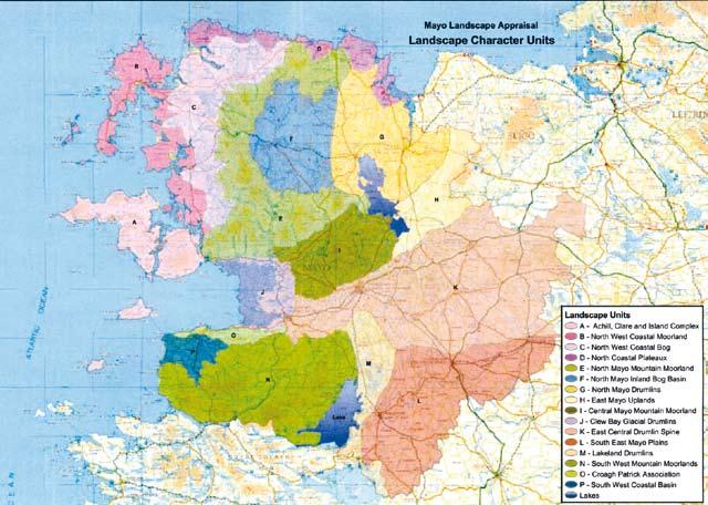
35 Figure15: Sample Landscape Character Assessments Completed in Ireland. County Mayo, County Offaly and County Kildare 33
36 2.3.2 Landscape Values Referring back to the model of the Landscape Character Assessment Process presented in Chapter 1 (Figure 2), the second stage in examining landscapes at a county or national level should be directed to assessing and mapping landscape values. For the purposes of this study, landscape values deals with the specific issues of (i) Scenic Landscapes and (ii) Scenic Routes and Views & Prospects. These are both dealt with separately below. Just as with mapping of landscape character, there is also a widespread diversity of approaches to landscape values along with confusion between the landscape concepts discussed earlier (Section 1.5). Since the 1963 Planning & Development Act, there has been a totally chaotic and uncoordinated approach to identifying, designating and managing scenic landscapes, scenic routes and views and prospects in Ireland Scenic Landscapes This section will review the scattered approach to mapping what can broadly be referred to as scenic landscapes, as follows: Five counties appear to have no classification of landscape values on the basis of the research carried out as part of this study. Some Local Authorities use five classes of landscape (for example Wicklow - Areas of Outstanding Natural Beauty, Area of Special Amenity, Corridor Area, Rural Area and Urban Area) whereas others use two categories (for example South Dublin High Amenity Areas and Outstanding Natural Character) and some just one classification (for example in Donegal - Areas of Especially High Amenity). The use of just one category of landscape value is regarded as insufficient in the opinion of the authors. In some counties a classification of Low Value is used (for example in Meath and in Galway). The authors of this report strongly contend that all landscapes are at least of some value and that the classification of low value could suggest that there is little need for protection or concern regarding of forces of change. There are certainly plenty of landscapes in Ireland which are of low quality, but this does not imply that they are of low value. At worst landscapes should perhaps be classified as Moderate in terms of value. Some Local Authorities have confused the concepts of landscape values with the making judgements on the sensitivity or capacity of areas to accept change. In Sligo and Waterford, for example, Visually Vulnerable ridges are highlighted without firstly identifying those locations as being of high value. A further problem with using such a classification is this it is not development specific. One ridge might be visually vulnerable to wind farms but not to afforestation, for example, whereas another might be vulnerable to one off houses but not to farm buildings. Judging from the titles used for landscape classes in some counties, there appears to be confusion between character and values. In Wicklow, for example, one of the categories of landscape value is entitled Corridor Area which generates an impression of a character type rather than being concerned with quality. Just fifteen counties use the classification of amenity in some form or other in their mapping and four of them use the term natural beauty. However, Section 10 of the Planning and Development Act, 2000, requires Local Authorities to preserve the amenities of places and features of natural beauty or interest. In classifying landscape value, therefore, the majority of Local Authorities have not taken the lead of using the terminology used in the Planning and Development Act, Even where neighbouring counties use the same or a very similar classification system for valuing landscape, conflicting judgements can arise on different sides of a county boundary. What is highly valued in one county might not be so highly valued in a neighbouring county. A county with very few mountains (such as might exist in the midlands) might place a high value on areas of elevated ground whereas the same elevated 34
37 ground might not be valued so highly in a neighbouring county which comprises extensive areas of dramatic mountains. This can lead to an inconsistency of classification of landscape values. The uncoordinated and chaotic approach used in relation to the identification of landscape values and scenic landscapes makes it impossible to get an overall nationwide impression of where the most special areas in Ireland are located. This is in stark contrast to our nearest neighbours in the UK where the identification of Areas of Outstanding Natural Beauty (AONB) back in 1949 (Figure 16) presents a coordinated and fully integrated approach. The current Irish approach also has adverse implications for tourism insofar as if there was a similar system in Ireland as exists in the UK, then it would be far easier to market those most special landscapes. The English AONB s are described as the jewels of the English landscape, designated solely for their landscape qualities for the purpose of conserving and enhancing their natural beauty (which includes landform and geology, plants and animals, landscape features and the rich history of human settlement over the centuries). An illustration of the different classification and mapping approaches to landscape values in Ireland is presented in Figure
38 Table 3: Review of Landscape Value Designations in Ireland County Designation Terminology Map on Council Website Carlow 5 no. Major Amenity Areas No Cavan High Landscape Amenity Areas Yes Clare None No Cork Scenic Landscapes Yes Donegal Areas of Especially High Scenic Amenity Yes Dun Laoghaire Rathdown High Amenity Areas Yes Fingal Amenity No Galway Map of 4 categories for Landscape Value Low/ Yes Medium/ High/ Outstanding Kerry Prime Special Amenity Areas/ Secondary Special Yes Amenity Areas Kildare Special Landscape Areas No Kilkenny Areas of High Amenity/ Scenic Views Yes Laois None No Leitrim Area of Outstanding Natural Beauty/ High Visual Yes Amenity Limerick None No Longford None No Louth Areas of Outstanding Natural Beauty/ Areas of High Yes Scenic Quality Mayo Scenic Evaluation Map in Landscape Appraisal No Meath Exception Value/ Very High Value/ High Value/ Yes Moderate Value/ Low Value Monaghan Areas of Primary Amenity Value, Areas of Secondary Yes Amenity Value Offaly Areas of High Amenity Yes Rocommon Moderate Value, High Value, Very High Value and No Exceptional Value Sligo Visually Vulnerable Areas Yes South Dublin High Amenity Areas/ Outstanding Natural Character No Tipperary North Areas of Primary Amenity No Tipperary South None No Waterford Visually Vulnerable Areas Yes Westmeath High Amenity Areas Yes Wexford Scenic Areas map Yes Wicklow Area of Outstanding Natural Beauty/ Special Amenity/ Rural Area/ Corridor Area Yes 36

39 Figure16: Areas of Outstanding Landscapes in England (first mapped in 1949) 37


40 Figure17: Illustration of Different Approaches used to Classify and Map Landscapes Values in Wicklow, Donegal and Meath 38
41 2.3.3 Scenic Routes and Views and Prospects The concept of Values in its most simple form in Ireland is typically represented by the designation of Scenic Routes and Views and Prospects and in this specific issue alone there is again widespread variance in approach, graphic presentation and associated policies. An overview of this variation of approach is outlined below: Some CDPs still have no map illustrating the location of scenic routes or views and prospects, whereas others have very high quality background mapping complemented by panoramic photographs. Arrows should be used to indicate the primary direction of the view or prospect in all such maps and reference numbers are needed so that interested parties can easily refer back to any written assessment of the view in question as well as establish what policies, if any, are applicable. In short, the mapping and referencing needs to be much more user-friendly. In relation to policies for scenic routes and views and prospects, the minimal policy statement typically includes such text as it is the policy of the Planning Authority to maintain the scenic and recreational value of these areas by restricting all adverse uses and negative visual impacts (Cavan County Council). In other instances, a much more direct and unequivocal policy recommendation is provided, such as Development proposals will not be permitted if it is considered they will cause significant harm to the intrinsic character, cause undue visual intrusion, be inconsistent with local character, harm the setting of buildings, structures or landmark features, harm historical / ecological value or harm local and strategic views of significance (Cork County Council). While there is a danger in being overly prescriptive in policy statements, the latter approach above is generally preferred over the former. The protection and maintenance of views and prospects is something that is rarely highlighted in CDP s, one such exception, however, being Kilkenny County Council wherein it is the policy of the Council to remove and or alter walls, fences, hedges or other obstructions and to control development so that views or prospects are not obstructed. This issue is becoming increasingly important with afforestation projects often enclosing views and prospects and single rural dwellings built on crests and hilltops availing of the best views. There are a few examples where County Councils approach the issues of scenic routes and views and prospects not just from a protection-orientated stance but also from a promotional and tourism perspective, such as Leitrim County Council It will be the Council s policy to continue to improve signposting in areas of particular interest and to facilitate access to features of outstanding quality by improvements to roads and creation of new rights of way. Lay-bys and viewing areas will be developed as appropriate and as funds allow. Lastly, a more integrative and coordinated cross-county approach is needed in respect of scenic routes and views and prospects, perhaps following the lead of Dun Laoghaire Rathdown County Council who state that the Council will take into account the views and prospects of adjoining counties in assessing applications for development. In short, there seems to be as many different approaches as there are Counties and some graphic samples of these are included for illustrative purposes in Figure 18 overleaf. A detailed table of all the various classifications used throughout the country is presented in Table 4. 39


42 Figure 18: Variety of approaches used in Cavan, Offaly and Meath County Development Plans to map Scenic Routes and Views and Prospects 40
43 Table 4: Review of Scenic Routes and Views and Prospects Maps in Ireland County Scenic Views & Scenic Routes terminology used Carlow Scenic Views Yes Cavan Walking Routes/ Scenic Viewing points Yes Clare Scenic Routes Yes Cork Scenic Routes Yes Donegal Views & Prospects/Scenic Roads/ Tourist Roads Dun Laoghaire Rathdown Preserve View/ Preserve Prospect Yes Fingal Preserve Views/ Visual Compartment Yes Galway Focal Points/ Views Yes Kerry Views & Prospects Yes Kildare Scenic Roads/ Hilltop Views/ Scenic View points Kilkenny Scenic Views Yes Laois Scenic Views Yes Leitrim Outstanding Views & Prospects/ Long Distance Walking Routes Limerick Views & Prospects/ Views Yes Longford Views & Prospects Yes Louth Scenic Routes/ View to Prospect Yes Mayo Highly Scenic View/ Scenic View/ Scenic Route Meath Key Viewpoints Yes Monaghan Views from Scenic Routes listed Yes Offaly Protected Views Yes Rocommon Scenic Views and Scenic Routes No Sligo Scenic Routes Yes South Dublin Views from Scenic Routes listed No Tipperary North Protected Views listed No Tipperary South View from location/ View along road Yes Waterford Scenic Routes Yes Westmeath Views to Be Preserved Yes Wexford Scenic Routes Yes Wicklow View of Special Amenity Yes Map on Council Website? Yes Yes Yes Yes 41

44 2.3.4 Landscape Sensitivity Thus far in this report it has been illustrated that there is a huge variety in approaches used throughout Ireland is classification of landscape character, landscape values as well as scenic routes and views and prospects. It will come as no surprise, therefore, to close this section of the report in highlighting that there is also total divergence nationally to the manner in which the issue of landscape sensitivity is dealt with. A summary of the variation in classification of landscape sensitivity is presented in Table 5 overleaf with key issues highlighted below: It would appear that some five Local Authorities have not yet included any classification of landscape sensitivity in their CDP and a further four counties use the map of scenic landscapes as their sensitivity map despite the fact that scenic landscapes should not necessarily be assumed to be sensitive. Of those that do classify landscape sensitivity, quite a number are generic (for example, High, Moderate and Low Sensitivity) and not development-specific. This is clearly contrary to draft guidance provided by the DoEHLG (2000) on this matter. Of those that deal with specific development kinds, wind farming above all other possible forces of change is by far the most prevalent (approximately 12 counties deal specifically with this matter). Just three Councils currently appear to have explicit and comprehensive sensitivity analysis for a broad variety of development kinds. Examples of cross-border inconsistency of classification in regards to landscape sensitivity can be found in many instances, as illustrated in Figure 19 below in relation to acceptability zoning for wind farm development in Clare, Limerick and Kerry. Figure 19: Mapping of Acceptability of Wind Farms in Clare, Limerick and Kerry 42
45 Table 5: Review of Landscape Sensitivity Maps in Ireland County Landscape Sensitivity Mapping Carlow None No Cavan Wind Farm Sensitivity No Clare Vulnerable Landscape Yes Cork Wind Farm Sensitivity Yes Donegal Same map as per scenic landscapes map Yes Dun Laoghaire Rathdown None identified No Fingal None No Galway Unique, Special, High, Moderate, Low Yes Kerry Wind Farm Sensitivity Yes Kildare Presented in tabular format: Sensitivity to 7 development No types in 11 Character Areas with a numerical sensitivity rating and rating of High/ Medium/ Low Kilkenny Wind Farm Sensitivity/ Areas of Development Pressure Yes Laois Special Areas of Development Control Yes Leitrim Wind Farm & Forestry Sensitivity Maps Yes Limerick Wind Farm Sensitivity Yes Longford Visually Important/Sensitive No Louth Wind Farm Sensitivity Yes Mayo Landscape Protection Policy Areas Map and Landscape Yes Sensitivity Matrix table for development types Meath High/ Moderate/ Low Sensitivity Also mapped is Yes Landscape Capacity indicating development types Monaghan None No Offaly High/ Moderate/ Low Sensitivity based on landcover Yes Rocommon Special Policy Areas No Sligo Normal Rural/ Sensitive Rural Yes South Dublin Same as landscape designations, includes Green Belts No Tipperary North 5 Sensitivity Categories Low/ Moderate/ High/ Special/ No Unique Tipperary South Wind Farm Sensitivity in upland areas only No Waterford Sensitive/ Normal/ Robust areas Yes Westmeath Same as per scenic landscapes map Yes Wexford Wind Farm Sensitivity Yes Wicklow Same as per scenic landscapes map Yes Map on Council Website? 43
46 44
47 Chapter 3 Stakeholder Consultation Research Findings 45
48 Consultation with a wide number of stakeholders was required in the Project Brief, the value of which was greatly appreciated by the consultants particularly when dealing with landscape issues. Stakeholder consultation methods used are listed below and the outcome of the first two of these is presented in outline directly thereafter: The circulation of a local authority questionnaire; A focus group meeting; and Meetings of the Steering Group A questionnaire was sent to the Planning and Development Department of all 34 planning authorities (29 County Councils and 5 City Councils). The questionnaire was divided into two sections; one dealing with GIS aspects 1 ; the other relating to landscape issues. The questionnaires were circulated in July Four months were allowed for the respondents to reply, after which the total number of completed questionnaires received was 18 out of 34 (53% response rate). A copy of the questionnaire as well as detailed answers to each question is available in Appendix 1. The questionnaire involved quantitative and qualitative questions, the former designed to produce statistical data, the latter designed to reveal the attitudes and opinions of those implementing landscape objectives at local authority level. A focus group meeting was held at the Fáilte Ireland Head Offices, Amiens Street, Dublin in July 2006, involving a presentation by the Consultants followed by discussion on the key issues involved in the feasibility study. The focus group comprised of key figures from the government departments, local authorities, government agencies and NGO s (a list of attendees can be found under the Acknowledgements to the fore of this report as well as in Appendix 1). A number of key issues emerged during the focus group meeting relating to the implementation of a proposed standardised scenic landscapes designation system. The issues are also outlined in bullet point form in Appendix 1 and are broadly grouped under the headings of Legislation, Landscape Designations and Inventory of Outstanding Landscapes The results of the questionnaire pertaining to GIS are presented elsewhere to Fáilte Ireland by Macro Works and MosArt 46
49 3.1 Conclusions from the Stakeholder Consultation Study The main conclusions arrived at following the analysis of the results from the questionnaire and the issues discussed at focus group meeting are summarised below. Satisfaction with Existing Scenic Landscapes Designation Half of the respondents are dissatisfied with their existing scenic landscape designations and the majority of them believe that development pressure is responsible for the down grading of their scenic landscapes. Many local authorities are unaware of how their scenic landscape designations compare with their neighbouring counties and just 10% of the respondents grade their scenic routes, views and prospects in terms of quality. An exception to this can be found in Mayo, for example, where they use Highly Scenic View versus Scenic View. The authors of this report suggest that such grading should be considered nationally as not all views are of the same quality. There are a variety of processes used by Local Authorities when evaluating the potential impact of a development on a scenic landscape. As an example, less that one quarter of respondents require the submission of before and after photomontages of the proposed project. Need for a National Scenic Landscapes Map There is wide support among Local Authorities for a national scenic landscape classification system. However, it must have regard to the LCA(1) process to avoid the concern expressed by some local authorities where a landscape that is locally designated as being scenic might be down-graded on a national level. The focus group meeting also concluded there is an urgent need for an integrated map designating scenic landscapes at a national level. However, when drawing up such a map it is important to address issues of scale when determining landscape values (for example, should the focus be on trophy landscapes of international status or on all landscapes irrespective of scale of importance). A standardised terminology should be agreed for dealing with landscape designations and existing legislation for the protection of landscape should be reviewed with respect to application in practice. Application of Planning and Development Act 2000 Local Authorities are under resourced in terms of appropriately trained professionals with responsibility for tackling landscape planning issues. There are currently no (LCA(2)) s and only 3 SAAOs in Ireland. Most local authorities are either simply not fulfilling their duties under Section 202 of the Planning and Development Act 2000 or, are unaware they have the power under the same act to designate an area an LCA or ASA. A number of respondents cited lack of political will (both at a local and national level) for the dearth of such designations in Ireland. 47
50 48
51 Chapter 4 A National Approach to Designating Scenic Landscapes in Ireland 49
52 The approach, methodology and criteria presented in this report are meant to provide a framework within which it would be possible to prepare a National Map of National Scenic Landscapes. This is not to be considered at the only option, but demonstrates that it would be possible to prepare such a map and provides a framework of how it could be done. It should be clarified at this point that landscapes are valued for many reasons and that scenery is just one dimension, albeit a critically important one. There will be many landscapes in Ireland that are not especially scenic but which are, nevertheless, highly valued because of their built heritage, natural heritage or cultural associations (dealt with previously in Section 1.5.4). An approach to mapping landscape values in Ireland is outlined below and from this all-encompassing values map, those landscapes that are valued specifically for their scenery would be extracted to produce a National Map of National Scenic Landscapes. A phased approach is thus advocated, firstly mapping values in a general sense followed by segregating out scenic phased landscapes. 4.1 Long Term Solution to a Long Term Problem The widespread stakeholder consultation employed in this study provides broad support for a national scenic landscapes map. The main concern with producing such a map, however, is that there will inevitably be landscapes that are currently valued within certain Local Authority areas that might not feature on a national scale. There might therefore be a perception that some landscapes have been devalued. However, the process that is being advocated in this study is about raising the status of some landscapes and not down-grading other landscapes. In the UK, The Countryside Agency uses the following criteria for defining landscapes of Scenic Interest : Land that has qualities well in excess of scenic land of its general type, assessed by national and not regional or local standards. Not all land within existing National Parks (NPs) and Areas of Outstanding Natural Beauty (AONB) will meet the high standards applicable to conditional exemption. Conversely, some land outside of NPs and AONB may qualify. Buildings and woodland may also be considered if they contribute to the outstanding interest 1. The benefits of a national scenic landscapes map are manifold, but the principal advantages are seen as follows: Instead of the total disparity that currently exists between local authorities, there would be a single nationally integrated map depicting the location of all scenic routes, scenic views, prospects and scenic landscapes. A national approach would ensure complete agreement of designations along county boundaries. In fact, the county boundaries would be overlaid on top of the national scenic landscapes map as the last stage in the entire process. The process required to produce such a map would result in the development of a single GIS coverage which could be made available digitally to interested parties. The availability of such a national digital map would be of benefit to parties engaged in the planning of large scale projects. Examples would include the upgrading of a national route that passes through a number of counties, or the assessment of an offshore wind farm that might be visible along a substantial section of coastline connecting several local authority areas. The same map would be of benefit to bodies with a concern for Ireland s landscape at a national level, including Fáilte Ireland, the Heritage Council, An Taisce, the National Roads Authority and many others
53 4.2 Outline Approach to Preparing a National Landscape Values Map The Heritage Council have advocated a nationally coordinated landscape characterisation study, establishing a fully integrated map detailing character areas and character types. The most efficient method of producing a national scenic landscape map would be to prepare it as part of a broader landscape values map in parallel with the landscape character map, perhaps involving the same independent assessment team coordinated by an identified national landscape agency. In reality, preparation of the landscape values maps would follow slightly in the wake of the characterisation study. The principle of this approach would be to (1) establish what physically exists (character), (2) determine the value of those landscapes and (3) identify those landscapes that are valued for their scenery (Figure 20). The mapping of scenic landscapes at a national scale would identify different classes of landscape, from those of international significance to those of national significance, regional significance and, lastly, those of local significance. A cut-off would be established whereby only those landscapes judged to be of international and national significance (by an identified National Landscape Agency) would be afforded national statutory protection (and mapped at a scale of 1:250,000 and 1:50,000). Such protection would be assured through the designation as either a Landscape Conservation Area or an Area of Special Amenity under the Planning and Development Act 2000 (Sections 204 and 202 respectively). The authors of this report do not believe there is a need to introduce new legislation over and above that which exists currently. The legislation is already in place the challenge now is to implement it as intended in the Planning and Development Act Landscapes of Regional and Local significance would be determined by the respective Local Authority, and afforded protection through the Local County Development Plan* (and mapped at a scale of 1:50,000). * Landscapes of International & National significance would also be presented on a county by county basis by LA s, however this would tie back in to the overall national map of landscape values (and through this the National Map of Scenic Landscapes). 51

54 Figure 20: Stepwise Approach to Mapping Character, Values and Scenic Landscapes at a National Level in Ireland 52
55 While all Local Authorities would be partners in the preparation of the national map, the concluding classification and resulting official designations would effectively be handed down from some higher level authority. This will ensure that national interests are to the fore in protecting landscapes of importance. There are several examples of such a procedure currently in use in Ireland, including the designation of csac s, NHA s, SPA s and the National Inventory of Architectural Heritage. Those landscapes that are highly valued but which do not make the above class for national designation could be adopted locally within County Development Plans using a coordinated classification system. This would solve the problem of the current menagerie of classifications currently in use. The above approach would thus produce two outcomes, namely (1) a list of national scenic landscapes worthy of statutory protection and (2) a coordinated landscape values classification system in all County Development Plans in Ireland. The outline procedure below might be used to develop a national map of landscape values: Identify the body that might lead the initiative; Establish an expert panel group of less than 10 members; Develop a project Brief and Scope of Works; Place the study out to tender and select panel of competent consultants (perhaps 3 to 5 groups) to work simultaneously and in partnership on the national study; Carry out review of existing county designations as well as field work and develop draft landscape values map (note: ignoring county boundaries) (refer to Section 4.3 below Methodology for Assessing Landscape Values); Categorise all valued landscapes according to why they are of value, including scenic landscapes; All Local Authorities would be invited to make submissions on the draft map - It would also be made available at a series of regional workshops; Engage interested parties through focus group meetings and refine draft values map; Integrate all draft maps onto national GIS map; Present findings at national conference to ratify findings and consider legislation implications (if any); Issue draft map for consultation; and Publish final map of values for Ireland. 4.3 Methodology for Assessing Landscape Values Assessing landscape values is a complex issue and there are no quick-fix assessment checklists available. Nevertheless, an overall approach is outlined in this section which will provide a practical way forward while also following best practice elsewhere. There is a broad consensus from material published in the UK and elsewhere (Spain, Hong Kong, New Zealand See Appendix 2) on what the core approach to dealing with landscape values might comprise: Define Study Purpose the purpose of the study should be clearly identified. As an example, is the study being specifically developed to serve the interests and needs of Fáilte Ireland in the protection of our best tourism assets or does it have wider application for other bodies. The entire study would have to be project managed, with a project plan and including a review process. Identify what is there most advice on the subject of landscape values and quality assessment emphasises the need to firstly classify landscape character. After classifying what is there, it is then possible to make 53
56 judgements on its value. A strong dimension of classifying landscape character should be the historical landscape aspect. The authors believe it would be unwise to proceed with preparing a national scenic landscape map prior to the completion of a landscape character map and landscape values map, therefore. Evaluation judgements regarding the value of any given landscape can be made on the basis of assessment criteria which are explored below (refer to Section 4.4 below - Criteria for Assessing Scenic Landscapes). It is generally accepted that this phase of the work should involve both professional evaluation as well as consultation. Develop a vision statement - a vision statement should be developed for each landscape ( what do we want this landscape to be like in 20 years ). This vision statement can provide the focus for Objectives and Policies. Identify forces for change trends in such matters as development, land use and settlement should be identified and consideration given to what effects this might have on the qualities of the landscape that makes is special. Policies and Objectives policies and objectives will need to be developed in order to guide change that will help to realise the vision for the landscape. Monitoring it is important to monitor the condition of the landscape over time to ensure that its special qualities do not deteriorate Synchronisation of Mapping Landscape Values with Mapping Landscape Character It has been recommended that the identification of landscape values would take place in parallel with a national assessment of landscape character. The latter study is likely to be coordinated by the Department of the Environment, Heritage and Local Government. The Heritage Council s assessment of the landscape character studies completed in Ireland thus far has highlighted the need for more coordinated and coherent approach. It seems prudent, therefore, that the DEHLG would use one team (perhaps involving a number of consultants) to complete the national landscape character map thereby safeguarding against repeating mistakes of the past. The likely timing of such a national landscape character assessment is unknown. 4.4 Criteria for Assessing Scenic Landscapes Assessing landscape values is complex and multidimensional. Landscapes can be valued for different reasons, and not just for their visual or aesthetic qualities. One landscape might be highly valued for its historical associations without being especially scenic, whereas another landscape might be of very high aesthetic quality while at the same time being of low ecological value. Some of the key dimensions of landscape value are listed below. It should be noted that many of these aspects were specifically mentioned by the Local Authorities that completed the study questionnaires in describing the highest quality landscapes in their county (included in italics below): Natural landscape, biodiversity, geology: Lakeland views framed by topography and field enclosure. Cultural archaeology, historic landscape, built environment, local traditions: The majestic grandeur of unencroached landscapes with literary, historic, archaeological and iconic associations. Environmental air quality, soil quality, water quality: Highly scenic extensive upland area prominent in views from all parts of the country providing easily accessible relief from urban environment. 54
57 Recreation rights of way, access land: Parks and open spaces enhance the quality of life for residents. Visual and sensory views, tranquility, sense of place: Views south across the county & north allow extensive visibility. The above landscape dimensions, once identified, can then be further assessed using significance criteria such as those listed below: Distinctiveness is the landscape distinctive from its surrounds as being easily identifiable in its own right? Quality is the landscape of high quality and in good condition? Rarity is the landscape rare at a national or international level? Representativeness does the area represent such a particularly good example of a given landscape type that it might be put forward as an especially good representation of that type? Sample Field Work Assessment Sheet Criteria that are drawn from the landscape dimensions mentioned above (natural, cultural, environmental, recreation and visual and sensory) are explored in Figure 21(a) and 21(b) below in the form a checklist of questions. The primary purpose of such a checklist is to ensure that assessors consider the full complexity of landscape when making judgements about value. One possible disadvantage, however, is the potential danger of becoming complacent and over-relying on prescriptive criteria. A checklist that has been used by MosArt for many years in their landscape impact assessment work is completed below for a real landscape, in this case Allihies, in west Cork, for the purposes of illustration (Figure 22). 4.5 Reviewing Scenic Routes and Views and Prospects The identification of scenic landscapes has been dealt with in outline above. This issue is the principle dimension of landscape value that is of interest to Fáilte Ireland. The other dimension is that of scenic routes and views and prospects. The survey questionnaire highlighted that many Local Authorities feel their scenic routes need to be reviewed. Some guidance developed as part of this study on how this might be approached is provided in Figure 23 below. The checklist criteria explored above could also be used in the review of scenic routes and views and prospects Case Study in Scenic routes mapping Kilglass Lakes, County Roscommon MosArt and Macro Works are currently preparing a landscape character assessment LCA(1) for Roscommon County Council to be included in their next County Development Plan ( ). As part of the field work required for that project, MosArt took the opportunity of testing the procedure set out in Figure 23 for qualification and mapping of existing routes. The results of this review are presented below in a step-by-step practical guide. 55
58 The following five stages were used for the case study review of the scenic route in Roscommon: Stage 1: Review Current Views and Prospects Designations Stage 2: Desk Study Appraisal of Landscape Context Stage 3: Use GIS Technology to Highlight Theoretical Visibility Stage 4: In-the-field Verification and Assessment Sub-Stage 4.1: Experience the character of the landscape Sub-Stage 4.2: Identify roads that provide views of the landscape Sub-Stage 4.3: Select and map the chosen Scenic Route Sub-Stage 4.4: Prepare written descriptions of the view on offer Stage 5: Mapping and Incorporation into CDP Stage 1: Review Current Views and Prospects Designations Some County Councils have not yet mapped their scenic routes, including instead just a written list of views and prospects. If this written description is not sufficiently detailed, it is likely that the specific location of the scenic route would be unclear and the protection of that view could therefore be undermined. The current Roscommon County Development Plan (2002) provides a useful example of this. While Roscommon County Council are in the process of preparing a detailed Landscape Character Assessment (LCA(1)) for their county, their views and prospects are currently presented as a list as can be seen in Figure 25 overleaf. In this extract from their current CDP, the Consultants have highlighted the Kilglass Lakes area as a case study for outlining a practical approach to mapping of scenic routes. Stage 2: Desk Study Appraisal of Landscape Context The map depicted in Figure 25 shows the Kilglass Lakes area on the OS Discovery Series map. As can be seen from this map, the area includes a scattering of small and medium sized lakes set in a rolling drumlin landscape. The lakes are contained by hills to the southwest and southeast and they ultimately all connect to the River Shannon to the east. There appears to be a considerable area of woodland throughout and the area is served by a network of roads including one regional road and a plethora of local roads. The rolling nature of the drumlin hills coupled with the woodland would suggest on the basis of a desk study that there would be limited long distance views available. Stage 3: Use GIS Technology to Highlight Theoretical Visibility Geographical Information Systems (GIS) technology is widely used amongst Local Authorities in Ireland and there are many tools in such systems that can be very helpful in landscape assessment. One such tool is identifying what is referred to as the Zone of Theoretical Visibility, or ZTV. Put simply, it is possible to highlight a feature in a landscape (in this case study a lake, for example) and find out using GIS what locations might theoretically be able to see that feature theoretically because the GIS assumes a completely naked landscape, without screening by trees, hedgerows or buildings. This ZTV exercise was carried out using all the lakes in the Kilglass Lakes area and the resulting map is included below in Figure 26. The map illustrates all the locations that can theoretically see the lakes in the Kilglass Lakes area Stage 4: In-the-field Verification and Assessment There are four sub-stages recommended in this element of the process, namely: (1) Experience at first hand the character of the landscape; (2) Identify which roads in the area actually provide views of the features of interest; (3) Map the location and extent of the road(s) that will be designated as a Scenic Route; and (4) Prepare written descriptions of the view on offer from the Scenic Route. 56

59 Figure 21(A): Sample Criteria for Assessment of Landscape Values 57


60 Figure 21(B): Sample Criteria for Assessment of Landscape of Landscape Values Figure 22: Application of Prototype Landscape Values Assessment Checklist 58

61 Figure 23: Diagram Illustrating the sample process for reviewing Scenic Routes 59
62 Figure 24: Extract from Current Roscommon County Development Plan Dealing with Views and Prospects as well as Areas of High Amenity Value (note highlighting of Kilglass lakes Area) 60

63 Figure 25: General View of the Kilglass Lakes area in northeast County Roscommon 61

64 Figure 26: Use of GIS technology to identify locations that have a view of the Kilglass Lakes 62

65 Each of these four sub-stages are described below in outline. Sub-Stage 4.1: Experience the character of the landscape Armed with the ZTV map depicted above, the landscape assessors can head out into-the-field and establish what the landscape looks like in reality. The image included below (Figure 27) illustrates the essential character of the Kilglass Lakes area, namely lakes, woods and amenity areas. It is useful to take high quality digital photographs of representative views in the landscape for later incorporation into the CDP. They will also serve as a useful reminder to the assessors of what the landscape has to offer in terms of character and quality. Figure 27: View of Kilglass Lakes Amenity Area Sub-Stage 4.2: Identify roads that provide views of the landscape The field work should then focus on finding out exactly where the best views are provided of the feature of interest (in this case the lakes). The ZTV map depicted in Figure 26 will often grossly exaggerate the availability of views which will be screened in reality by trees and buildings. The assessors visited the Kilglass Lakes area and found that there are just two roads that provide open views over a reasonable stretch of the features of interest. Of these roads, the busier regional road provides the most elevated and panoramic views over the landscape, so it was decided to use this road as the basis for the proposed Scenic Route (Figure 32). Sub-Stage 4.3: Select and map the chosen Scenic Route The third task for the field work is to map the extent of the Scenic Route. In other words, where does the route begin and where does it end. The direction of the view should also be recorded, namely, whether it is a complete 360 degree panorama or whether it is in one direction only. In the case study in question, MosArt employed a satellite navigation (SATNAV) system to map the location and extent of the route (Figure 28). As one assessor is driving, the other is examining the view and also looking at a real-time map on the SATNAV which shows exactly where the car in which they are travelling is located. Once the view opens out in the direction of the Kilglass Lakes, the location was marked on-screen as was the location where the view eventually disappears (Figure 29). The beginning and end locations can then be directly downloaded into a GIS back at base. 63


66 Figure 28: Use of Satellite Navigation Equipment in-the-field for Landscape Assessment Figure 29: Detailed Mapping of Scenic Routes using satellite Navigation Systems 64


67 Sub-Stage 4.4: Prepare written descriptions of the view on offer The fourth and final task to complete while on-site is to prepare a written assessment of the view, noting such things as character, grid reference, direction of view, features of interest, forces of change and overall quality. These notes can later be incorporated into the Council s GIS system. Highlighting forces of change will help to alert Planning staff to development that might bring about a change in character and overall quality. A sample assessment sheet completed by MosArt in the Kilglass Lakes area is included below (Figure 30) for the purposes of illustration. A panoramic photograph of the view is also included below, the likes of which should be included in the CDP along with the map of the Scenic Route (Figure 31). Figure 30: Sample Field Assessment Sheet for Scenic Routes and Scenic Landscapes Figure 31: Representative Panoramic Photograph of View from Scenic Route 65
 is depicted below in Figure 32.")
68 Stage 5: Mapping and Incorporation into CDP The final stage in this process is to depict the designated Scenic Route on OS Discovery Series background maps, including providing an indication of the direction of view. The sample route in the case of the Kilglass Lakes area (indicative only) is depicted below in Figure 32. Figure 32: Location of Indicative Scenic Route as well as Scenic Landscape visible from that Route 66
69 Chapter 5 Conclusion and Key Recommendations 67
70 5.1 Summary of Key Issues There are a number of means by which Ireland s special landscapes are afforded protection which include designation as either a Landscape Conservation Area 1, Special Amenity Area 2 or National Park 3 or more generally through Section 10(2) of the Planning and Development Act which focuses on preservation of views and prospects as well as amenities and features of natural beauty or interest. Taking the above three national designation methods, one might reasonably imagine that given Ireland s internationally renowned reputation as a highly scenic country that there would be several such designated landscapes throughout the State. Further, since Ireland has ratified the European Landscape Convention (ELC 4 ), specifically requiring the protection of landscape, it might be assumed that each county had at least one, if not more of, such areas. Bizarrely, however not a single Landscape Conservation Area (LCA(2)) exists, there are just three Special Amenity Area Orders and these in the immediate context of Dublin City and six National Parks, five of which are located in the western Atlantic counties. This lack of protection is happening at a time when, in the last three years alone, there has been over quarter of a million new houses built in Ireland 5, with 40% of these being one-offs in the countryside. The NRA is coordinating an unprecedented road building programme, wind farms are being erected to serve our energy needs and farmland is being abandoned due to downward pressure on farm incomes. Ireland is undergoing massive forces for change in parallel with the raging Tiger Economy and now is the time, more than ever, when we need to take stock of our landscape assets in establishing what exists and what requires protecting. The last effort to present a national overview of our best landscapes was almost thirty years ago and until very recently, there has been a deafening silence on the issue. Now is the time to rectify the lack of an integrated strategic approach to landscape management. In 2006, the Heritage Council undertook a very revealing study of the current situation in Ireland with regards to Landscape Character Assessment (LCA(1)). The Report reveals a summary of how the process is being applied throughout the country. In short, there appears to be a widespread lack of understanding among Local Authorities of how landscape characterisation might best be applied resulting in broad scale inconsistencies in methodology and, accordingly, usefulness of the studies. The Heritage Council s study is critically important insofar as it serves as a wake-up call regarding the state of play of landscape characterisation in Ireland. A more coherent approach is clearly needed, to be driven by a revision of the current (Draft) Landscape and Landscape Assessment Guidelines issued by the Department of the Environment, Heritage and Local Government in In a questionnaire survey of Local Authorities in Ireland carried out as part of this study, it was found that there is a need for a revision of the current landscape designations on the basis that the process used in evaluating the potential impact of a planning application on a scenic landscape is inconsistent. Many local authorities are unaware how their scenic landscape designations compare with their neighbouring counties. Half of them are dissatisfied with their existing scenic landscape designations and the majority of them believe that development pressure is responsible for the down grading of their scenic landscapes. 1 Section 204 of the Planning and Development Act 2000, enables a planning authority to designate any area or place as a Landscape Conservation Area, for the purpose of the preserving of the landscape. 2 Section 202 of the Planning and Development Act 2000, enables a planning authority to declare an area to be of special amenity, by reason of its outstanding natural beauty or its special recreational value and having regard to any benefits for nature conservation. 3 In 1969, the International Union for the Conservation of Nature (IUCN) recommended that all governments agree to reserve the term National Park to areas sharing specific characteristics. It is the policy of the Department of the Environment, Heritage and Local Government, endorsed by successive governments, to abide by the criteria and standards for the National Parks laid down by the IUCN. 4 Wishing to provide a new instrument focused exclusively on the protection, management and planning of all landscapes in Europe, member states of the Council of Europe came together at The European Landscape Convention in They acknowledged the role landscape plays in the social needs, economic activity and the environment. They agreed that, in the interests of sustainable development, the landscapes of Europe should be assessed and mapped. This information would then inform landscape and land use policy at local level
71 5.2 Main Conclusion The principle conclusion that can be drawn from this report is outlined below: That a national Scenic Landscapes Map would be both feasible and useful as a long term solution to the existing chaotic collection of disparate approaches designation of scenic landscapes in Ireland. Furthermore, following in the wake of preparing first a character map, followed by a values map, the scenic landscapes map would lead to the identification of landscapes of national and international renown, as well as those of regional and local importance. The feasibility of producing a national landscape values map is outlined in detail in chapter 4, along with an overview of the overall approach. It is stressed that existing landscape legislation can be used to protect those most important landscapes. There would be two outcomes of a national study on landscape values, namely (1) a national map of National scenic landscapes worthy of statutory protection and (2) a coordinated landscape values classification system in all County Development Plans in Ireland. In addition to investigating the feasibility and benefit to Fáilte Ireland and other prescribed bodies of conducting a general landscape values map, the report proposes criteria for assessing scenic landscapes and provides a practical example of how to identify and assess scenic landscapes in the field (including a checklist). A detailed case study on identification, mapping and assessment of scenic routes, views and prospects is also provided. 5.3 Recommendations The conclusion that this study has arrived at can be achieved through three stepwise actions. Action 1: Pilot Study It is proposed as part of this report that a Pilot Study be implemented, as a fore runner to a national study to implement and test an outline methodology for identifying and mapping landscape values and scenic landscapes. This pilot study might involve a number of counties, including County Clare where the Heritage Council conducted their Pilot Landscape Character Study (2000). Action 2: Revised and Illustrated Guidance to Ensure Consistency among Local Authorities in dealing with Scenic Landscapes, Scenic Routes and Views and Prospects The most recent guidance on landscape assessment in Ireland was issued in Draft in 2000 but notably contains no detailed or practical advice on how to identify, designate, map and manage development in what might loosely be referred to as scenic landscapes. There is an urgent need to develop a graphically illustrated suite of practical guidance documents detailing the stepwise approach that should be used nationally to identify and protect what is our greatest tourism asset the Irish landscape. The diversity of approaches, products and policies concerning scenic routes and views and prospects in Ireland would make it very difficult to produce a fully integrated national map. In the future all counties should adopt a standardised approach in reviewing their scenic routes and views and prospects, including high quality mapping and user-friendly referencing. Policies should not be solely focused on protection, but should seek opportunities for enhancement and enjoyment, provide examples of what might injure visual amenities, make reference to possible impacts on neighbouring counties and link with the overall approach to Landscape Characterisation. 69
72 Action 3: Prepare a full and detailed landscape values map Detailed maps of landscape values and scenic landscapes should be prepared in parallel with a national assessment of landscape character in Ireland. This map would be GIS based and would require extensive field work as well as consultation. The Landscape Values map of Ireland will be used by Local Authorities, Fáilte Ireland, as well as other prescribed bodies, in the planning process. In terms of appearance, such a map might resemble the English map of Areas of Outstanding Natural Beauty presented in Chapter 2 (Figure 16). 5.4 Order of Magnitude Cost of Preparing a National Landscape Values Map The Heritage Council s study highlighted that the average cost of preparing a landscape characterisation study in Ireland is between 30,000 and 70,000 per county, in other words 50,000. A lot of these studies involve both character as well as some kind of values / quality / sensitivity. It is noted that many of the studies carried out thus far have not involved local consultation (for example through public meetings) and have not incorporated the use of GIS. The use of both of these elements would increase the cost of the studies. Compensating for such cost increases, however, is the fact that the study would run in parallel with a national landscape characterisation appraisal. There would be an overlap in terms of desk studies, field assessments, data resources and mapping. 70
73 Bibliography AALAN, F. et al (Eds) Atlas of the Irish Rural Landscape, Cork University Press, Cork. AN FORAS FORBARTHA Inventory of Outstanding Landscapes in Ireland, Dublin. BORD FAILTE Developing Sustainable Tourism: Tourism Development Plan Dublin. BUCKLAND, M.C. (date unknown). LA4 s Landscape Assessment Methodology [online]. Text. Available from: documents2005/rural_study_la4_notes.pdf [accessed August 2006] COUNTRYSIDE AGENCY et al Mapping Tranquility: Defining and Assessing a Valuable Resource [online]. Text. Available from: uk/campaigns/landscape/tranquillity/national-and-regional-tranquillity-maps [accessed June 2006] COUNTRYSIDE AGENCY & SCOTTISH NATURAL HERITAGE Landscape Character Assessment: Guidance for England and Scotland 2002, University of Sheffield, UK. COUNTRYSIDE AGENCY et al Quality of Life Capital: Managing environmental, Social and Economic Benefits. Prepared by CAG Consultants. UK. COUNTRYSIDE AGENCY & SCOTTISH NATURAL HERITAGE. Topic Paper No 5: Understanding Historic Landscape Character. University of Sheffield, UK. COUNTRYSIDE AGENCY & SCOTTISH NATURAL HERITAGE. Topic Paper No 6: Techniques & Criteria for Judging Capacity and Sensitivity. University of Sheffield, UK. COUNCIL OF EUROPE European Landscape Convention [online]. Text. Available from: Co-operation/ Environment/Landscape/Presentation/9_Text/02_Convention_EN.htm [accessed July 2006] DANIEL, T. C Whither scenic beauty? Visual landscape quality assessment in 21st century in Lange, E and Bishop, I (Eds), Our Visual Landscape: Analysis, Modelling, Visualization and Protection in Landscape and Urban Planning, Volume 54, Issues 1-4, 25 May 2001, pp.1-3. DEPARTMENT OF ENVIRONMENT, HERITAGE AND LOCAL GOVERNMENT Draft Landscape and Landscape Assessment: Consultation Guidelines for Planning Authorities, DoEHLG, Dublin. DEPARTMENT OF ENVIRONMENT, HERITAGE AND LOCAL GOVERNMENT National Spatial Strategy for Ireland , The Stationary Office, Dublin. DEPARTMENT OF FINANCE National Development Plan , The Stationary Office, Dublin. ENVIRONMENT AND HERITAGE SERVICE NORTHERN IRELAND (date unknown). Methodology for Mapping Areas of Outstanding Natural Beauty in Northern Ireland. UK. FAILTE IRELAND Analysis of Landscape and Amenity Policies within Ireland s County Development Plans (unpublished). GRIST, B. AND MACKEN, J. (Eds) Irish Planning Law Factbook, Thomson Round Hall, Dublin THE HERITAGE COUNCIL The Heritage Act [online]. Text. Available from: [accessed July 2006] THE HERITAGE COUNCIL Pilot Study on Landscape Characterisation in County Clare, prepared by ERM and ERA-Maptec Ltd, Kilkenny. THE HERITAGE COUNCIL, Landscape Character Assessment in Ireland: Baseline Audit and Evaluation, prepared by Julie Martin Associates, Kilkenny. THE IRISH STATUE BOOK. Local Government (Planning and Development) Act 1963 [online]. Text. Available from: [accessed May 2006] THE IRISH STATUE BOOK The Planning and Development Act 2000 [online]. Text. Available from: [accessed May 2006] MARITIME IRLAND/WALES INTERREG Guide to Best Practice in Seascape Assessment. Prepared by Countryside Council for Wales, Brady Shipman Martin, and University College Dublin. Dublin. OBSERVATORI DEL PAISATGE Catalan Landscape Observatory [online]. Text. Available from: [accessed July 2006] 71
74 72
75 Appendix 1 Local Authority Survey Questionnaire and Results And Focus Group Meeting Findings 73


76 Survey Questionnaire Results The results of the quantitative questions from the landscape aspect of questionnaire are presented below in pie chart form and followed by analysis, where as the qualitative results are discussed in more detail. Question: Outline the process used by your Planning and Development Department in evaluating the potential impact of a planning application on a scenic landscape or scenic route / view / prospect? Only 28% stated that they require a planner to make a site visit when evaluating the potential impact of a planning application on a scenic landscape. Another 28% stated that they consult the list of scenic landscapes in their CDP. 22% said they request the applicant to produce photomontages.16% said they use a combination of criteria including site visits, the erection of ridge/marker poles and the use of photomontages. Overall the results show that there are a variety of processes used by local authorities when evaluating the potential impact of a planning application on a scenic landscape. Question: Have there been any Landscape Conservation Areas designated in your county (under Section 202 of the Planning and Development Act 2000)? This result compares well to the Heritage Council s findings, which states there are currently no Landscape Conservation Areas in Ireland designated under Section 202 of the Planning and Development Act


77 Question: If the answer to the above question is No, please tell us why not 16% of local authorities specifically stated there was no political will to designate Landscape Conservation Areas. Some of the comments put forward were as follows: It will have to be voted in by elected members. One proposal to extend an area of development control was sadly defeated. No Ministerial direction has been received (in fact, the Minister only has the power to make regulations prescribing development which shall not be exempted development within LCAs). 16% said that existing designations were adequate. While 1 local authority cited the lack of guidance and another stated a lack of resources as to why there are no Landscape Conservation Areas, 39% gave no reason at all, which perhaps demonstrates a lack of knowledge of the duties and powers local authorities have in respect to Section 202 of the Planning and Development Act Question: Have there been any Areas of Special Amenity designated in your county (under Section 202 of the Planning and Development Act 2000)? What is revealing in this result is that 22% of local authorities replied that they did have an SAAO in their county. This result was unexpected, as according to the DoEHLG there are only 3 SAAOs nationally, all of which are in County Dublin 1. Further research into this result (follow up phone calls with local Authorities) revealed that there seems to be a lack of understanding as to the definition of an SAAO. The question had been misinterpreted as meaning other types of landscape designations, for example: scenic routes or views. 1 Howth Head SAAO, North Bull Island SAAO and Liffey Valley SAAO. 75


78 Question: If the answer is No, please tell us why not Although 33% gave no answer the question, 34% of local authorities specifically stated there was no political will to designate SAAOs. Some of the comments were as follows: There is no particular impetus or demand from any quarter. There is no direction from the Minister [although the Minister may direct a local authority to make an SAAO and the local authority must comply with a direction from the Minister in this regard, each local authority has the power to designate areas of special amenity]. It will have to be voted in by elected members. Question: Does your County Development Plan specifically designate Tourist Amenity Areas as distinct from other generic classifications such as scenic areas, scenic routes / views and prospects? The vast majority of local authorities have no Tourist Amenity Areas classified in their CDPs. One local authority however stated that they use an Integrated Leisure Development classification which seems to suggest they have identified areas suitable for the development of (built) tourist facilities, as opposed to the identification of landscapes which are suitable as a tourist amenity. 76

 identify potentially new")
79 Question: Are all scenic routes / views and prospects classified equally in terms of perceived quality, or are they graded (for example highly scenic versus just scenic ). The predominant lack of a classification system that grades landscape quality prompts the question that surely not all views are the same or equal? A national system would propose that scenic landscapes are classified according to landscape value primarily (as per Landscape Character Assessment) and would also consider the aspect of quality. Question: Are you entirely satisfied with the current designations of scenic routes views and prospects or do you think that they should be reviewed perhaps in order to (a) identify potentially new examples or (b) to downgrade others which perhaps have deteriorated in quality over the past years? Half of respondents were dissatisfied with the designation of their scenic routes views and prospects. Possible reasons for this might be: They felt that some of the scenic routes, views and prospects designated are unworthy of the designation. They felt that the system that was used to assess to set the designation was inadequate. That the designation itself had not been effective in preserving the quality of the scenic routes, views and prospects. The result demonstrates that there is a need for guidelines that local authorities can implement in the assessment of scenic landscapes. 77
80 Question: In what situations, if any, might an existing designated scenic route, views or prospects be downgraded / declassified? 9 out of 18 Local Authority respondents cited development pressure as the main reason for the downgrading of existing scenic routes, views and prospects. 3 respondents specifically cited forestry as the main type of development that can compromise the quality of a scenic landscape. This result reveals a perception that forestry can be an unattractive change in the landscape, although we do not find out if it is a specific type of forestry (i.e. conifer or broadleaf) or if it is the management of forestry that is the basis of the negative impact on the scenic landscapes. Question: According to your opinion, could you please list the top five landscapes in your county and tell us why you think they are so special The aim of this question was not necessarily to find out where the most scenic landscapes in the country are, but rather to reveal what makes them so special. The language used to describe why these landscapes are considered highly scenic was very interesting. The descriptions provided by the respondents can be grouped under the following criteria; Physical; Perceptual; Emotional; and Association. Physical Lakeland views framed by topography and field enclosure. Highly scenic linear river valley landscape extending from mountain area Many different landscape areas available. Mixture of natural and manmade water ways of industrial archaeological importance. Provides a natural backdrop to the city. Interface between sea and rocky shore interspersed by secluded beaches, is highly dramatic. The patchwork of agricultural landscapes. The north ridges contribute to setting & character of Cork City. Views of landmark buildings are visual landmarks of the city. The majestic grandeur of unencroached landscapes with literary, historic, archaeological and iconic associations. The spectacular seascapes with indented coastlines. Inherent landscape variations due to land uses. The river provides an excellent centre piece for settlements in the county. Perceptual Views south across the county & north allow extensive visibility. The scale of visibility. Scenic road access and light quality. Rural in character with views limited to the immediate environment. Emotional Highly scenic extensive upland area prominent in views from all parts of the country providing easily accessible relief from urban environment. Parks and open spaces enhance the quality of life for residents. The inland textured landscape, contrasting the lake and the historic mountain landscape with variations in intimacy. 78

81 Association Strong mythological associations. Highly scenic extensive river valley landscape with significant historical associations. The continuous mountains from a distinctive feature for the region. When listing the Top Five Landscapes in each county, some respondents listed Landscape Character Types and some listed Landscape Character Areas. Question: At present there appears to be a broad variety of approaches used in Ireland in the assessment of scenic landscapes and scenic routes, views and prospects. Do you think it would be better if the same approach and classification system was used nationally or should each Local Authority have the freedom to use whichever system they feel best suits their county? The vast majority of local authorities, 72%, indicated that they would prefer a national approach when assessing scenic landscapes. Of those that indicated they would prefer to use their own county system for assessing scenic landscapes, 1 of these specifically stated that a national system would devalue the scenic landscapes of their county. They stated that their county would be compared to counties that are well known for their scenic landscapes. Overall there appears to be a need for a national assessment system, however there is some fear that a national system could in fact serve to devalue some scenic landscapes. The challenge therefore is to develop a system that will on the one hand classify scenic landscapes at a national level, but on the other hand protect the best landscapes available in counties that are not generally renowned for being scenic. 79

82 Question: How would you describe the degree of consistency between the designated scenic landscapes and scenic routes / views and prospects in your county compared with those of your neighbouring Local Authority? 44% of local authorities did not know how consistent their scenic landscape designations are compared with their neighbouring counties. Two of these commented that there is no consistency between urban and rural landscape designations within their own local authority boundary. Of the 39% that said they were moderately consistent, one commented that the management policies of scenic landscapes neighbouring local authorities also needed to be more consistent. 80
83 Focus Group Meeting Findings A focus group meeting was held at the Fáilte Ireland Head Offices, Amiens Street, Dublin on Thursday 20th July A number of key issues emerged during the focus group meeting relating to the implementation of both a proposed national GIS and standardised scenic landscapes designation system. The issues pertaining to the latter can be grouped under the following headings: Referrals System Many planning application referrals are made without giving supporting documentation as to why the referral is being made. The Prescribed Body might not know, therefore, why they are being referred the planning application. The referral process between Local Authorities and Prescribed Bodies is generally regarded as being highly inconsistent. Legislation Local authorities are legally required to adhere to designations such as Special Areas of Conservation (SACs) and Natural Heritage Areas (NHAs). However it is at the discretion of local authorities to implement any landscape guidelines issued by the DoEHLG. A legislative vacuum exists between the requirement of local authorities to implement Section 202, of the Planning and Development Act 2000 and the reality at local authority level. Currently, there are currently no Landscape Conservation Areas in Ireland. Fáilte Ireland will need to identify the central issues in order to drive strategic change. The central issues identified were: The National Development Plan. County Development Plans e-planning and its potential to link in with a National Landscape Character Map. Landscape Designations Local authorities sometimes use designations such as high amenity areas for development control purposes. This effectively means that potential development sites are designated as landscapes with protection policies attached. A national map would prevent Local Authorities inappropriately designating areas. The process of making value judgements about landscapes should be removed from local authorities. There are opportunities for identifying landscapes with future tourism potential. In particular looking at the changing face of Irish landscapes. For example, the decline in agriculture and the changes in farming process in the peat lands for example. Landscapes such as turloughs, peat lands or unique seasonal landscapes have tourism potential and perhaps should given a landscape designation for this reason. Inventory of Outstanding Landscapes 1977 The 1977 map does not include peri-urban areas. Any scenic landscapes map should come with guidelines to ensure its appropriate use. Local authorities started adding designations to the 1977 map, but there was inconsistency and many different terms were used. Overall the 1977 map is useful, but there is a need for a good GIS system that incorporates value judgements, perhaps using public consultation. 81
84 Other models A document called Inspire is a 2007 Draft European Directive dealing with spatial data infrastructure (a mechanism for different data to come together on an internet data base for sharing data and common standards). See Mayo County Council and Donegal County Council have established an excellent GIS system that links into an online planning system. Focus Group Attendees The focus group comprised of key figures from the following governments departments, local authorities, government agencies and non governmental agencies. It should be noted that not all comments listed above are attributable to all members of the Focus Group. The Attendees are listed below: Mr. Bruce McCormack, Inspector, Heritage and Planning, Department of the Environment, Custom House, Dublin 1. Mr. Noel Casserly, Comhar: The National Sustainable Development Partnership, 17 St. Andrew Street, Dublin 2. Mr. Michael Starrett, Chief Executive, The Heritage Council, Rothe House, Parliament Street, Kilkenny. Mr. Philip Jones, Vice-President, Irish Planning Institute, c/o An Bord Pleanála, 64 Marlborough Street, Dublin 1. Mr. Aidan Ffrench, President, Irish Landscape Institute, c/o Dún Laoghaire County Council, County Hall, Marine Road, Dún Laoghaire, Co. Dublin. Ms. Claire Gilligan, Local Government Computer Services Board, Phoenix House, Conynghan Road, Dublin 8. Mr. Pat Farrington, Landscape Architect, Forest Service, The Department of Agriculture and Food, Johnstown Castle Estate, Wexford. Mr Frank Barrett, Department of Agriculture and Food, Johnstown Castle Estate, Wexford. Mr. Ian Lumley, Heritage Officer, An Taisce, Tailor s Hall, Back Lane, Dublin 8. Ms Fiona Lawlor, GIS Officer, Environmental Protection Agency, PO Box 3000, Johnstown Castle Estate, Co. Wexford. Darragh McDonagh, Donegal County Council, County Hall, Lifford, Co. Donegal. Paddy Mathews, Environment Unit, Fáilte Ireland, Baggot Street, Dublin. Nik Hennessy, Managing Director, MacroWorks, Dublin. Tomas O Leary, Managing Director, MosArt Landscape Architecture Research, Wicklow Lisa Smyth, Landscape Architect, MosArt Landscape Architecture Research, Wicklow 82

85 Appendix 2 International Best Practice of Methods for Assessment of Landscape Values 83
86 Some examples of international best practice in the field of landscape assessment are included below. An abstract description of various studies, guidelines and methodologies is initially provided below, followed by key extracts from the source material. 1. UK Overview Report - Quality of Life Capital Approach (Country Agency, English Nature English Heritage & the Environment Agency) Developed jointly by the Countryside Agency, English Nature, English Heritage and the Environment Agency to provide a consistent and integrated way of managing for quality of life. In 1998/9, eighteen pilot projects applied the approach to a range of different tasks. One finding from these pilots and other research is that the approach is as valid for social and economic as for environmental benefits. An overall approach is recommended including specifying study purpose, identify what is there, determine benefits and services, evaluation, prepare policy and management implications and monitoring. 2. UK Landscape Character Assessment Guidance for England and Scotland (Natural England) Natural England in the UK has developed a suite of practical guidance documents dealing with landscape assessment. Chapter 7 of these guidelines focuses on Making Judgements Based on Landscape Character and includes key criteria that might be used in evaluating landscape value, namely landscape quality, scenic quality, rarity, representativeness, conservation interests, wildness, associations and tranquillity. Such evaluation will of necessity be based on professional input but should also include stakeholder consultation as an integral part of the process. 3. UK Guide to Best Practice in Seascape Assessment (Countryside Council for Wales, Brady Shipmen Martin & UCD) The Countryside Council for Wales, Brady Shipman Martin and University College Dublin developed a comprehensive guide to seascape assessment in These guidelines propose a stepwise approach to assessing and mapping coastal landscapes, including the use of GIS to determine landscape visibility as well as a field-work assessment checklist of aesthetic and perceptual factors. 4. UK Mapping Tranquillity, Defining & Assessing a Valuable Resource (CPRE & The Countryside Agency) The Campaign to Protect Rural England (CPRE) North East and The Countryside Agency commissioned a report to develop a methodology for mapping tranquility. The methodology had to be robust and could support a range of activities, with land-use and landscape planning foremost amongst them. It has established that qualitative consultation of a wide range of countryside users and other groups can be accommodated within a quantitative framework for analysis and mapping, thereby drawing tranquility into the range of available countryside quality indicators. 5. Spain Catalan Landscape Observatory (2005) The Landscape Observatory is an advisory body of the Catalan Authorities and for awakening society to matters of landscape. It studies landscape, monitors it, prepares proposals and sensitises society to the appropriateness of better protection, management and planning of the landscape in Catalonia in the context of sustainable development. It supports the application of the European Landscape Convention in Catalonia and is conceived as a centre for thought and action in relation to landscape. 84
87 6. Hong Kong Mapping Character, Condition, Sensitivity and Values An approach to landscape recently applied in Hong Kong outlines a stepwise appraisal of mapping character, condition, sensitivity and values. Landscape value is appraised on the basis of a number of attributes, including a landscape s visual coherence, complexity, rarity, relief and condition, key heritage/natural features and visual attractors / detractors. The evaluation has been applied to determine which are the best and most attractive landscapes and which are not so good, so that actions which may adversely affect attractive landscapes can be avoided. 7. New Zealand - Landscape Assessment Methodology (LA4 Architects Ltd.) A landscape architectural practice based in Auckland, New Zealand, have developed an approach to rating and mapping landscape achieved through a combination of landscape quality (value) and landscape vulnerability. An abstract of their work is included below. 8. US Journal of Landscapes & Urban Planning, Whither scenic beauty? Visual landscape quality assessment in the 21st century (Daniel, Larry C.) A Journal Paper by Terry C. Daniel et al entitled Whither scenic beauty? Visual landscape quality assessment in the 21st century proposes a psychophysical approach to landscape evaluation which integrates the 20th Century emphasis on expert and perceptual assessment with the 21st Century need to consider a deeper ecology and green philosophy. The author is one of the world s leading authorities on the theory of landscape and landscape assessment. 85
88 1. UK - Overview Report - Quality of Life Capital Approach (Countryside Agency, English Nature, English Heritage and the Environment Agency) March 2001 prepared by CAG Consultants and Land Use Consultants Quality of life capital: determining what matters and why The Quality of Life Capital approach was developed jointly by the Countryside Agency. English Nature. English Heritage and the Environment Agency to provide a consistent and integrated way of managing for quality of life. It has been developed by CAG Consultants and Land Use Consultants, originally under the name of Environmental Capital. In 1998/9 eighteen pilot projects applied the approach to a range of different tasks. One finding from these pilots and other research is that the approach is as valid for social and economic as for environmental benefits. It has thus been renamed the Quality of Life (QoL) Capital approach. Introduction This guide describes how to use the Quality of Life Capital approach as a tool for identifying what matters and why, so that the consequences (both good and bad) of plans, development proposals and management options on quality of life can be better taken into account by practitioners and decision takers. This guide concentrates on those benefits for human quality of life that come from the environment, because the method has been most thoroughly piloted and tested on these, and because planners and practitioners often need a tool for this specific purpose. However as the box above explains, the same method can embrace social and economic capital too. Guidance on these will be added to he website as and when these applications of the method are well enough tested in practice. Meanwhile it should be remembered that this guide deals in detail only with the environmental aspects of quality of life capital. It offers a strategic overview of what this approach is; what tasks it can potentially help with (including two worked examples); where it is appropriate to use; how it relates to other appraisal methods and decision support tools. What is Quality of Life Capital for? Politicians, policy makers, planners and developers continually face decisions which seem to set different social, economic and environmental goals against each other. Where should new development be accommodated? Is a loss of green space or outlook justified to create jobs or housing? How should visitor pressures be managed in a beautiful but fragile landscape? 86
89 Decisions like these cry out for a fair and comprehensive method for setting out and comparing all the different pluses and minuses of different options, taking account of both expert and lay views. This is what QoL Capital seeks to provide. It: stands back from things or places and considers the benefits or services that they provide for human well-being ( what matters and why? ) provides a consistent, systematic and transparent evaluation framework for all scales of decision making Integrates environmental, social and economic issues emphasises improvement of quality of life rather than acceptance of the status quo values the commonplace as well as the unusual and rare facilitates participation, putting professional/expert judgements alongside the concerns of local people works with other tools and processes including environmental impact assessment, sustainability appraisal, Community Planning and Best Value. In a specifically planning context, it shows where and in what form and with what conditions development can be accommodated with the least possible loss or damage, and helps to halt the creeping erosion of quality of life. The core idea: benefits and services The core idea of QoL Capital is that the environment, the economy and society provide a range of benefits for human life, and that it is these benefits or services which we need to protect and/or enhance. (We use both terms, benefit and service, because neither captures the meaning perfectly on its own.) For example consider a small mixed woodland on the edge of a town. QoL Capital says it s not the hectares of woodland that matter in themselves, it s the capacity of the wood to provide tranquil recreation, habitat for rare species, stabilise the soil, retain water, mop up carbon dioxide and local air pollution - and perhaps also support a livelihood in charcoal burning or coppice timber products. Of course this is not a new idea. The idea that a stock of assets should be safeguarded to ensure a flow of benefits underlies much of economics and previous thinking in this area. It has guided a great deal of good planning practice for years. Many development plans, appraisals, planning officers reports on proposed developments and such like already apply the ideas behind the QoL Capital approach. All that s new is to set out in a thorough and explicit way what has previously been more piecemeal, partial and implicit, and a methodical framework to make it easier for all practitioners to do thoroughly and consistently what some are already doing. The advantages this offers are: putting all kinds of social, economic and environmental service - from the most technical and scientific to the most subjective and social - in the same framework; combining a range of specialist, technical and community inputs; providing a systematic framework for deriving policies or management objectives from them The Quality of Life Capital process All applications of the approach involve the same 6 basic steps. This section introduces them; subsequent ones discuss them in more detail (see also further information at the end of this report). Step A: Purpose The same basic approach can help with a wide range of different decisions and planning processes, from site briefs to regional planning guidance. But the details of what you need to do vary greatly with the purpose. So the essential first step is to be clear about the purpose of the study. This guide concentrates on examples from planning and environmental management. 87
90 Step B: Identifying what is there The purpose of the exercise (step A) will imply which sources of social, economic and environmental benefits need to be studied. A variety of techniques including traditional survey methods and character assessment may be useful for identifying environmental features depending on scale and circumstances. For example, regional planning guidance will need to look at what is special or important at the level of the region. At the other extreme, a development control application can look solely at the ways the proposed development would affect the local area. For comparing potential development sites already identified, QoL Capital could concentrate on the differences between them, whereas an exercise carried out to identify possible sites would need to consider the whole area. Step C: Benefits and services The key to the method is to ask: what are the benefits and services which are potentially affected by the planning process or the decision at issue? Many places or environmental features provide a wide range of different services, and being clear about the purpose of the study enables the work to concentrate on the issues that matter and can be influenced. Step D: Evaluation This examines the benefits and services systematically, using a series of questions: who the services matter to, why, and at what spatial scale: for example habitat quality may matter for biodiversity at a regional or national scale, while recreational access may matter for quite specific groups of people from a small local area; how important are they, which is a distinct question from the previous one: a service that matters at national level is not necessarily more important than one that matters only locally; whether we have enough of them - it is more important to maintain services which are in short supply (or in danger of becoming so) than ones that are plentiful (though obviously there are degrees of scarcity, and the method should not be used as an excuse to let things decline to the minimum acceptable level). Where we currently do not have enough, the aim should be increase; what (if anything) could make up for any loss or damage to the service - for example other places local people could go equally readily for the same types of recreation, or other areas that could be managed to support displaced communities of bird species. (Many services - notably historical and cultural significance - can not be substituted.) Expert judgement and community views both need to be reflected, so QoL Capital draws on both public consultation and involvement processes and technical appraisal methods including (for environmental benefits and services) environmental impact assessment, landscape, ecological, archaeological and characterisation studies. Step E: Policy / management implications From the evaluation, this step draws clear messages about the aims or policies which would be needed to ensure that social, economic and environmental benefits were maintained or enhanced rather than damaged. The form these take will depend on what decision or process the exercise is feeding in to. For example structure plan policies need to be framed very differently to planning obligations for a particular site - another reason why it is so important to be clear about the purpose for the study in advance. Step F: Monitoring The benefits and services identified as important in the process are, for this very reason, the aspects of the environment which should be monitored. QoL Capital thus provides its own performance indicators. 88
91 2. UK-Landscape Character Assessment Guidance for England & Scotland (Natural England) Chapter 7 - Making Judgements based on Landscape Character 7.1 The use of Landscape Character Assessment in making judgements is a fast-moving scene amongst practitioners. This chapter sets out some main principles on the subject. Topic Paper 6, Techniques and criteria for judging capacity and sensitivity, will be issued in the Summer of 2002 to address one of the key areas where practitioners need to make judgements on this topic. 7.2 The main value of having a Landscape Character Assessment is to help in the process of managing change in a particular place. All sorts of change will shape future landscapes, and by applying this tool in an appropriate way, alongside other tools, we can help to ensure that such changes make a positive contribution. 7.3 For this reason, most assessments will usually move beyond the characterisation stage to the stage of making judgements to inform particular decisions. Making judgements as part of an assessment should not concentrate only on the maintenance of existing character. This may be one part of the judgements made. The focus should be on ensuring that land use change or development proposals are planned and designed to achieve an appropriate relationship (and most often a fit ) with their surroundings, and wherever possible contribute to enhancement of the landscape, in some cases by creating a new character. 7.4 Judgements based on landscape character need to take account of several factors. Most importantly it is vital to decide who is going to be involved in making the judgements. For practical reasons some assessments may still rely mainly on judgements made by professionals. It is nevertheless important to involve stakeholders in this part of the process if the judgements are to command wide support and are to be as fully informed as possible. Many different stakeholder groups need to be given opportunities to contribute, especially: those who manage the land, especially farmers and foresters; local residents and community groups; other users of the land, including visitors and those who take part in recreational activities. 7.5 An historical perspective is important to help understand the way in which a landscape has evolved over time to take on its present character, and how both natural forces and human intervention have contributed to its evolution. With such understanding, decisions about future change can be placed in an historical context and ideas about, for example, restoration of some earlier historic character can be well-informed and based on a sound historical rationale (see Topic Paper 5). What Types of Judgements? 7.6 Ways of making judgements based on character will vary depending upon the particular issue that is being addressed. This in turn will reflect the purpose of the assessment and the type of judgements that are required. As set out in Chapter 2 (para 2.10), these judgements will either: be specifically related to decision-making based on landscape character; or be designed to contribute to wider environmental decision making tools where landscape is only one of several topics to be addressed. 89
92 7.7 A number of such environmental and sustainability decision-making tools now exist. Some, like Environmental Impact Assessment and landscape capacity studies, are well established. Others, like the Natural Heritage Futures programme (used in Scotland), and Quality of Life Capital (in England) are newer and still emerging. Landscape Character Assessment links to these tools in different ways. Topic Paper 2 provides information about these tools. It particularly highlights the way that these tools and initiatives can be informed by Landscape Character Assessment. Main Considerations in Making Judgements 7.8 Approaches to making judgements that are focused on landscape character, as distinct from these broader environmental tools, have continued to evolve particularly over the last ten years as practitioners have gained more experience in the practical application of techniques. These approaches are generally based on one or more of the following considerations, namely the character, quality (condition of features), value of the landscape, and its sensitivity to change. These terms need to be understood if there is to be consistency in approaches taken. The definitions recommended by the Agencies are as follows: Landscape character means the distinct and recognisable pattern of elements that occurs consistently in a particular type of landscape, and how these are perceived by people. It reflects particular combinations of geology, landform, soils, vegetation, land use and human settlement. It creates the particular sense of place of different areas of the landscape. Landscape quality (or condition) is based on judgements about the physical state of the landscape, and about its intactness, from visual, functional, and ecological perspectives. It also reflects the state of repair of individual features and elements which make up the character in any one place. Landscape value is concerned with the relative value that is attached to different landscapes. In a policy context the usual basis for recognising certain highly valued landscapes is through the application of a local or national landscape designation. Yet a landscape may be valued by different communities of interest for many different reasons without any formal designation, recognising, for example, perceptual aspects such as scenic beauty, tranquillity or wildness; special cultural associations; the influence and presence of other conservation interests; or the existence of a consensus about importance, either nationally or locally. Landscape capacity refers to the degree to which a particular landscape character type or area is able to accommodate change without significant effects on its character, or overall change of landscape character type. Capacity is likely to vary according to the type and nature of change being proposed. 7.9 In deciding on the approach to making judgements there must be a clear rationale which is explained to the assessment s users. This will help make the assessment and its application more robust and accountable. Defining Objectives 7.10 The rationale for judgements will need to establish the balance between the following objectives for landscape types and areas: Conservation and maintenance of existing character; Enhancement of existing character through the introduction of new elements and features or different management of existing ones; Restoration of character, where this is appropriate to current land use activities and stakeholders preferences, and is economically viable through either public or private money or a mix of both; Creation of or accelerating change towards a new character; or Some combination of these options, especially where regeneration activity is occurring, involving much development and change. 90

93 7.11 Developing such a rationale will require careful thought about the overall character and key characteristics of the landscape today, and the dynamics of the landscape, in terms of recent change, current trends and future forces. This will help to determine both the desirability and practicability of maintaining current character. Approaches to Making Judgements 7.12 The approach taken to making judgements will usually vary depending on the particular applications for which the assessment is to be used. One of the following four approaches is usually adopted. i. Landscape strategies 7.13 A Landscape Character Assessment may lead to a strategy for the landscape based on what change, if any, is thought to be desirable for a particular landscape character type (or area) as a whole. The judgements underpinning such strategies need to be transparent but not overly complex, and will usually relate in some way to the objectives set out in para To ensure they are widely owned and can be implemented, they should be devised and tested through stakeholder involvement where possible To date, practitioners have used landscape strategies to guide thinking on the desirability of: maintaining the existing landscape character; enhancing character; restoring some former landscape, or creating a new one When used in the field of planning policy, for example as a basis for structure or local plan policies, the strategy approach may be used to indicate the preferred approach for each policy zone within the plan and to provide a basis for landscape and development policies. In other circumstances, aspects of landscape value (paras ) may help to identify areas for some form of landscape status or designation. 91

94 ii. Landscape guidelines 7.16 A Landscape Character Assessment will normally identify the character of an area and those factors that are particularly important in creating that character, usually referred to as key characteristics. If the distinctive character of a certain landscape is to be maintained, the assumption must be that its positive key characteristics should be protected from adverse change and, conversely, that the effects of negative characteristics will be overcome by some form of enhancement. This assumption provides the basis for judgements about the actions necessary to achieve this (Box 7.1) Field survey should identify the physical state of individual elements and features, and, in combination with consultation and additional research, should indicate the probability of future change, and its nature and direction (trends or forces for change ). Considering all this information together should then reveal opportunities either to prevent those changes which may have adverse consequences for landscape character, or to maximise opportunities for enhancement. This requires careful thought about the importance attached to characteristic features and about the likelihood of either positive or negative change This type of analysis usually results in the drawing up of landscape guidelines to indicate the actions required to ensure that distinctive character is maintained or, if appropriate, enhanced. This approach has been adopted in the majority of published assessments in England and Scotland. Such guidelines are often produced in written form, and are sub-divided according to both the landscape type in question and the main pressures likely to result in landscape change, namely agriculture, forestry, settlement and built development, mineral working, tourism and recreation, and infrastructure (Box 7.2). 92
.")
95 7.19 Guidelines can also be presented graphically. This is particularly useful when dealing with design issues. In the Sussex Downs AONB graphic guidelines are available in a loose-leaf folder designed to assist in communicating ideas to farmers and land managers (Figure 7.1). The Skye and Lochalsh character assessment in Scotland has also taken a highly graphic approach to both the descriptions of landscape character and to the guidelines (Figure 7.2) As guidelines are designed to influence the way in which landscapes are managed it is highly desirable that the many stakeholders involved in day-to-day management are actively involved in the process. This will help to ensure that the guidelines are based on a good understanding of real world land uses and land management practices, and that there will be a good prospect that they can be practically implemented. iii. Attaching status to landscapes 7.21 Where a tract of landscape is selected for special recognition, judgements need to be based on a range of different considerations. National landscape designations in England and Scotland are based on criteria that encompass much more than landscape alone. The key considerations are: natural beauty: encompasses flora, fauna, geological and physiographical features and is the term that has been used in defining AONBs and National Parks in England; recreational opportunity: opportunities afforded for open-air recreation, having regard both to landscape character and position in relation to centres of population. (Also used in defining National Parks in England); natural beauty and amenity: a composite term, used in the founding legislation of SNH contained with The Natural Heritage (Scotland) Act The Act defines the natural heritage as including the physical elements of flora, fauna, geology, physiographic features and natural beauty and amenity. This combination of terms covers the physical landscape, but also the less tangible aspects such as remoteness or tranquillity, and aspects of landscape experience which appeal to senses other than sight, such as the sound or smell of the sea. 93
. This refers to the relative value or importance that stakeholders attach to different landscapes and their reasons for valuing them.")
96 7.22 In considering natural beauty and amenity, and in any other situation which requires that a landscape be identified as requiring special attention, judgements must be based at least in part on the concept of landscape value (para 7.8). This refers to the relative value or importance that stakeholders attach to different landscapes and their reasons for valuing them. The reasons may be set out according to a range of more detailed criteria that may include the following: landscape quality: the intactness of the landscape and the condition of features and elements (para 7.8); scenic quality: the term that is used to describe landscapes which appeal primarily to the visual senses; rarity: the presence of rare features and elements in the landscape, or the presence of a rare landscape character type; representativeness: whether the landscape contains a particular character, and/or features and elements, which is felt by stakeholders to be worthy of representing; conservation interests: the presence of features of particular wildlife, earth science or archaeological, historical and cultural interest can add to the value of a landscape as well as having value in their own right; wildness: the presence of wild (or relatively wild) character in the landscape which makes a particular contribution to sense of place; associations with particular people, artists, writers, or other media, or events in history. There may often be a consensus of opinion about the value of an area encompassing one or more of these criteria, which can be traced over time from the views expressed by different stakeholders Tranquillity: In addition to these landscape-related criteria there is another criterion, tranquillity, that is a composite feature related to low levels of built development, traffic, noise and artificial lighting. Authors of Landscape Character Assessments must state their criteria for low levels clearly and should also consider whether one or more of the factors needs to be addressed individually, rather than in combination. Policy makers and practitioners may find it useful to refer to the Tranquil Areas maps [54]. Tranquil area mapping is currently underway in Scotland, as is the identification of core wild land areas The full range of criteria set out above may be used to identify valued landscapes that merit some form of designation or recognition. They can be used, either individually or in combination, to assist the definition of nationally important areas throughout England and Scotland. These include National Parks, areas of Outstanding Natural Beauty, National Scenic Areas, and equivalent areas. 94
97 7.25 The criteria of natural beauty, recreational opportunity and natural beauty and amenity can be the starting points for selecting the broad area of search for designation or recognition of special areas. The criteria listed in paras 7.22 and 7.23 could be used to provide a supporting statement about why a particular area is valued. Boundaries can then be determined by assessing the character and quality of the landscapes within the area of search to determine whether or not they should be included (see Chapter 9 for further detail). iv. Landscape capacity 7.26 Many Landscape Character Assessments will be used to help in decisions about the ability of an area to accommodate change, either as a result of new development, or some other form of land use change, such as the introduction of new features, or major change in land cover such as new woodland planting. In these circumstances judgements must be based on an understanding of the ability of the landscape to accommodate change without significant effects on its character. Criteria for what constitutes significant change need to be identified in planning policies or landscape strategies, and will usually be informed by potential effects on character and/or particular features and elements. Good Practice Pointers It is particularly important to find ways of involving stakeholders in this part of the process if the judgements made are to command wide support. The approach taken to making judgements based on character will vary depending upon the issue being addressed and must be designed to meet the particular circumstances. Some approaches to making judgements are an integral part of the Landscape Character Assessment process. Others are wider environmental evaluation processes to which Landscape Character Assessment can make a valuable contribution. There must be a clear rationale behind the approach to making judgements, which will help to determine the eventual outcome. This will require careful thought about the overall character and key characteristics of the landscape, its history and origins, and the opportunities that may exist to create new landscapes to meet the emerging social, economic and environmental needs of stakeholders. It is particularly important that: the reasons for adopting a particular approach to making judgements are made clear; the approach (or combination of approaches) used must be clearly explained and transparent; the extent and nature of stakeholder involvement should be made clear. 95
98 3. UK - Guide to Best Practice in Seascape Assessment (Countryside Council for Wales, Brady Shipman Martin, UCD) 1 Summary of the process of characterisation for national units. As part of a desk study the national unit, within which the regional or local unit is located, should be identified and the issues arising understood. As suggested in Chapter 4, the national units would be mapped by national agencies on the basis of the following criteria: Zone of Visual Influence (both land and sea) Unique or rare geomorphologic or landscape features Major public access points to the coast and the sea Access to the sea for commercial and recreational use Marine and coastal recreation Cultural and historic links Landscape designations Conservation designations Marine and coastal habitats Pre-Study Familiarisation In order to properly structure the assessment it is necessary to undertake the following: Familiarisation with the National unit within which the area is located. Ordnance Survey maps, sea charts, pilot books and almanacs should be obtained. Familiarisation with the tidal range and tidal features. Familiarisation with scientific or other designations. The cultural associations and history of that particular section of coast should be researched and the relevance to particular landmarks and features in the sea understood. Familiarisation with social, commercial, and amenity uses. Familiarisation with any landscape characterisation studies carried out on the coast and adjoining lands. 2 Summary of the process of characterisation for regional and local units There are 4 basic stages required to assess regional and local units, they are: Area definition by visual criteria, and appropriate buffers; Visual analysis of visibility, view points and views ; Characteristics for sea, coastline and land parts of each area; Integration of sea, coastline and land components together. Stage 4, integration, actually describes seascape character and provides the necessary information to be taken forward to evaluation. The stages are described in some detail in the following sections. See flow diagram, following page. 96
99 4. UK - Mapping Tranquility - Defining & Assessing a Valuable Resource (CPRE, The Countryside Agency) The word tranquillity appears in a great many policy and planning documents, and also numerous publications which promote places for tourism and inward investment. It is clear that whatever tranquillity is, and wherever it is to be found, it is important and judged to be worth protecting. Previous psychological research has highlighted why tranquillity is important. Being in tranquil places allows people to relax, to escape from the stresses and strains of everyday life and to recharge their batteries. However, tranquillity remains relatively poorly understood as a concept. Tranquillity is seen as an indicator of environmental quality, but most environmental indicators focus on tangible, quantifiable attributes such as the length of hedgerows, water quality or the accessibility of green space. Qualitative, experiential aspects of landscape are far harder to account for. Tranquillity runs the risk of being overlooked because of this perceived difficulty. This research was commissioned to develop a methodology that was robust and could support a range of activities, with land-use and landscape planning foremost amongst them. It has established that a qualitative consultation of a wide range of countryside users and other groups can be accommodated within a quantitative framework for analysis and mapping, thereby drawing tranquillity into the range of available countryside quality indicators. 97
100 Method: assessing and mapping relative tranquillity Tranquillity mapping is not a new concept. It was first developed by Simon Rendel of ASH Consulting for a Department of Transport study in The original study led to the production of a set of Tranquil Area maps covering England, produced by Rendel and ASH Consulting, and published by the Campaign to Protect Rural England (CPRE) and the former Countryside Commission (1995). In these maps, Tranquil Areas were defined as: places which are sufficiently far away from the visual or noise intrusion of development or traffic to be considered unspoiled by urban influences 2.These places were identified through specific criteria, with Tranquil Areas being found certain distances away from features such as roads, towns, airports and power stations. We have built on this body of work. More sophisticated mapping techniques are now available, and we have used extensive public consultation as the basis for the maps. This means that the maps produced by our research are not an update of the original maps because the methodology is not directly comparable. However, our work significantly advances our appreciation of what comprises tranquillity, what detracts from it, and how to identify tranquil areas within a given region. The methodology developed here differs from the previous work on tranquillity mapping in four key ways: Rather than starting with an expert definition of what compromises tranquillity, we have started with extensive public and stakeholder consultation to define what factors contribute to and detract from tranquillity; Previous work has focused exclusively on factors that detract from tranquillity. Our approach includes factors that contribute to, as well as detract from tranquillity; We use the term relative tranquillity to describe what we are mapping. Relatively tranquil areas are those which have higher scores for the positive factors, and lower scores for the negative factors, than other areas. Our maps reveal areas, both large and small, where people are likely to experience tranquillity. But they do not include sharp lines dividing tranquil from non-tranquil areas; and Our approach incorporates more advanced modelling techniques to look at the diffusion of these factors impact over distance. This has allowed us to produce detailed surface maps which give every place a tranquillity score rather than crude zones of tranquil/non tranquil, or high/medium/ low tranquillity. In 2000, a detailed critique of the original CPRE maps was published 3. It argued that what was needed was a measure of tranquillity that included all, and only, those sources of disturbance which people feel actually damage tranquillity; and which weighted them in proportion to peoples perceptions of their relative impacts on tranquillity. This is exactly what we have done. 98

101 WHAT IS TRANQUILITY? Perceived links to nature Positive features in the landscape The importance of wildlife Peace, quiet and calm WHAT IS NOT TRANQUILITY? Disruptive behaviour of other people Noise, especially from cars Overt signs of human development - negative features in the landscape Above: Countryside near Medomsley in the West Durham Coalfield and traffic on the A167(M), Newcastle Assessing people s experiences: using Participatory Appraisal Our new maps were drawn on the basis of what tranquillity means to people, why it is important, and where it is to be found. To do this, we carried out Participatory Appraisal (PA) with people in two pilot study areas in North East England: the Northumberland National Park and the West Durham Coalfield in County Durham. PA is a method of understanding people s values and beliefs. It enables them to discuss what is important to them in their own words. In this research, PA involved groups of key local stakeholders in both study areas and people at countryside access points. The table below shows our headline findings from PA about what contributes to and detracts from tranquillity. 99
102 5. Spain - Catalan Landscape Observatory (2005) Why is it important? Because the quality of life of people depends on landscape: the urban or rural surroundings, degraded areas or others of high quality, unique areas or everyday areas. Because it reflects the good or ill health of the relationships between society and the land. It is an excellent indicator of environmental quality. Because it is another factor in well-being. The European Landscape Convention makes the quality of landscape into a right (the right to enjoy agreeable, harmonious landscapes, not degraded, which transmit various cultural and territorial identities). Because It offers pleasing sensations (aesthetic, sensory, emotional). Because it identifies us with the land, with the country. Landscape is a reflection of past lifestyles and, specifically, our history, and thus it has value as part of our heritage. What is the Lanscape Observatory? The Landscape Observatory is an advisory body of the Catalan Authorities and for awakening society to matters of landscape. It studies landscape, monitors it, prepares proposals and sensitises society to the appropriateness of better protection, management and planning of the landscape in Catalonia in the context of sustainable development. It is the meeting point between the Generalitat de Catalunya (Government of Catalonia), local authorities, universities, professional groups and, in general, Catalan society, in connection with the management and preservation of landscape. It supports the application of the European Landscape Convention in Catalonia. It is conceived as a centre for thought and action in relation to landscape. The Landscape Observatory, legally formed on 30 November 2004, is organized as a consortium and is included in the Act for the Protection, Management and Planning of the Landscape of Catalonia. Functions of the Observatory Establishing mechanisms of observation of the evolution and transformation of landscape. Fixing criteria to establish the objectives of landscape quality and adopt the measures of protection, management and planning of landscape necessary to achieve these objectives. Proposing actions directed to the improvement, restoration or creation of landscape. Preparing the landscape catalogues of Catalonia, destined to identify and evaluate the various landscapes. Preparing a four-yearly report on the state of the landscape in Catalonia for the Catalan Parliament. Following up European initiatives in landscape matters. Stimulating scientific and academic collaboration in landscape matters, and the exchange of work and experiences among specialists from universities and other academic and cultural institutions. Promoting campaigns of social sensitisation with regard to landscape, its functions and how it evolves and is transformed. Dissemination of studies and reports, and establishing working methodologies in landscape matters. Organizing seminars, courses, conferences and exhibitions on landscape policies. 100
103 101

104 The landscape catalogues of Catalonia The Act for the Protection, Management and Planning of the Landscape of Catalonia defines these as documents of a descriptive and prospective nature which identify the types of landscapes in Catalonia, their values and state of preservation, and propose the quality objectives to be met. The landscape catalogues are tools which enable us to know what our landscape is like and what values it has, the factors that explain why we have that type of landscape and not another, how it has evolved with regard to current social economic and environmental dynamics and, finally, the catalogues define what types of landscape we want and how to achieve them. Seven landscape catalogues have been prepared, coinciding with the seven territorial regions in which the new territorial organization of Catalonia will be structured. 102

105 6. Hong Kong - Mapping Character, Condition, Sensitivity & Values 103
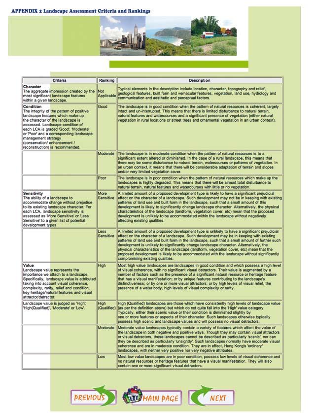
106 104
Connecting rural dwellings with rural development
 Connecting rural dwellings with rural development Dr Mark Scott Department of Planning and Environmental Policy University College Dublin Mark.Scott@ucd.ie Introduction Growing emphasis in the EU is being
7. The Landscape. 7.1 Introduction. Environmental Impact Statement (EIS) Scoping Report
 Scoping Report") 7. The Landscape 7.1 Introduction The purpose of this section of the EIS Scoping Report is to describe the scope of work and methods to be applied in the identification and assessment of landscape and
7. The Landscape 7.1 Introduction The purpose of this section of the EIS Scoping Report is to describe the scope of work and methods to be applied in the identification and assessment of landscape and
Supplementary Information: LCA Review Forms
 Final Report to The Heritage Council Landscape Character Assessment in Ireland: Baseline Audit and Evaluation Supplementary Information: LCA Review Forms March 2006 Julie Martin Associates The Round House
LANDSCAPE CHARACTER ASSESSMENT
 THE COUNTY DURHAM LANDSCAPE CHARACTER ASSESSMENT FOREWORD The landscape of County Durham is one of great contrast and diversity. From the North Pennines in the west to the Durham Coast in the east it contains
Cotswolds AONB Landscape Strategy and Guidelines. June 2016
 Cotswolds AONB Landscape Strategy and Guidelines June 2016 Cotswolds AONB Landscape Strategy and Guidelines Introduction The evolution of the landscape of the Cotswolds AONB is a result of the interaction
Landscape Policy in Ireland insights from the Heritage Council
 Landscape Policy in Ireland insights from the Heritage Council Ian Doyle Head of Conservation What am I going to talk about? What is landscape? European Landscape Convention Local landscape projects Methods
The RPII s radon road shows. Hugh Synnott Scientific Officer Radon Advice Section
 The RPII s radon road shows Hugh Synnott Scientific Officer Radon Advice Section 1 Structure of Presentation Background Main objectives of road shows Structure and format of road shows Impact of road shows
Landscape Character Assessment (LCA) in Ireland: Baseline Audit and Evaluation
 in Ireland: Baseline Audit and Evaluation") Landscape Character Assessment (LCA) in Ireland: Baseline Audit and Evaluation Sept 2006 Prepared by Julie Martin Associates in Association with Alison Farmer Associates AN CHOMHAIRLE OIDHREACHTA THE HERITAGE
Landscape Character Assessment (LCA) in Ireland: Baseline Audit and Evaluation Sept 2006 Prepared by Julie Martin Associates in Association with Alison Farmer Associates AN CHOMHAIRLE OIDHREACHTA THE HERITAGE
3 Urban Design and the State Highway Network
 NZ Transport Agency Page 1 of 14 Urban Design Professional Services Guide 1 Introduction This is a professional services guide on urban design, which provides direction to the NZ Transport Agency (NZTA)
TOPIC PAPER 2: Links to other sustainability tools
 TOPIC PAPER 2: INTRODUCTION 1.1 Landscape Character Assessment can inform a range of other sustainability tools and methodologies. Equally these other tools may assist in reaching decisions concerning
Strategic Environmental Assessment Screening Report. Dublin Port Masterplan Review 2017
 Strategic Environmental Assessment Screening Report Dublin Port Masterplan Review 2017 Table of Contents 1 Introduction... 1 2 Purpose of the Masterplan... 2 3 Task 1.1 Pre-Screening Check... 5 4 Task
THE NATIONAL RADON SURVEY IN IRELAND. S.G. Fennell, G.M. Mackin, J.S. Madden and A.T. McGarry
 Radon in the Living Environment, 136 THE NATIONAL RADON SURVEY IN IRELAND S.G. Fennell, G.M. Mackin, J.S. Madden and A.T. McGarry Radiological Protection Institute of Ireland, 3 Clonskeagh Square, Clonskeagh
MAKING SENSE OF PLACE
 MAKING SENSE OF PLACE Landscape Character Assessment Summary Guidance for England and Scotland MAKING SENSE OF PLACE People can welcome development if it is well designed and contributes to quality of
Oxford Green Belt Study. Summary of Final Report Prepared by LUC October 2015
 Oxford Green Belt Study Summary of Final Report Prepared by LUC October 2015 Project Title: Oxford Green Belt Study Client: Oxfordshire County Council Version Date Version Details Prepared by Checked by
CREATING GREEN INFRASTRUCTURE FOR IRELAND
 CREATING GREEN INFRASTRUCTURE FOR IRELAND Dr William Hynes Downey Hynes Partnership 15 th September 2010 Overview of Presentation Definition of GI Legislation and Policy Background Examples of GI-type
Landscape Identification and Assessment in Ireland: an overview
 Landscape Identification and Assessment in Ireland: an overview Nessa Roche Department of Arts, Heritage and the Gaeltacht Custom House, Dublin 1, Ireland nessa.roche@ahg.gov.ie Heritage Council 2013:
Tara Skryne Landscape Conservation Area Project: Progress Report: Phase 1
 Tara Skryne Landscape Conservation Area Project: Progress Report: Phase 1 A partnership project between Meath County Council, the Heritage Council and the Department of Environment, Heritage and Local
SUSTAINABLE MANAGEMENT
 . Sustainable Management.1 The Concept of Sustainable Management The concept of sustainable management recognises there are limits to the use of natural and physical resources and there is a need to balance
Suffolk Coastal Local Plan Review Issues and Options, August 2017, Public Consultation
 Suffolk Coastal Local Plan Review Issues and Options, August 2017, Public Consultation Having reviewed the issues and options documents, the Society has made the following response: Part 1 - Strategic
Appendix. Statement Outlining Compliance with Ministerial Guidelines
 18 Appendix Statement Outlining Compliance with Ministerial Guidelines A18 Statement Outlining Compliance with Ministerial Guidelines Under section 28 of the Planning and Development Act 2010, Meath County
LANDMAP Methodology Overview
 LANDMAP Methodology Overview June 2017 Jill Bullen, Senior Landscape Specialist jill.bullen@cyfoethnaturiolcymru.gov.uk 0300 065 4706 (Please note this is an information document and not a training presentation)
9 Archaeology & Cultural Heritage
 High Clachaig Wind Farm Scoping Report Page 56 9 Archaeology & Cultural Heritage 9.1 Introduction Cultural heritage in this context means the above- and below-ground archaeological resources, built heritage,
The European Landscape Convention And National Landscape Strategy. Tony Williams Irish Landscape Institute
 The European Landscape Convention And National Landscape Strategy As a reflection of European identity and diversity, the landscape is our living natural and cultural heritage, be it ordinary or outstanding,
12 TH ANNUAL CHILTERNS AONB PLANNING CONFERENCE ENGLISH HERITAGE: HISTORIC ENVIRONMENT GOOD PRACTICE ADVICE
 12 TH ANNUAL CHILTERNS AONB PLANNING CONFERENCE ENGLISH HERITAGE: HISTORIC ENVIRONMENT GOOD PRACTICE ADVICE MARTIN SMALL HISTORIC ENVIRONMENT PLANNING ADVISER ENGLISH HERITAGE Policy ENGLISH HERITAGE GOOD
building with nature - a new benchmark for green infrastructure
 building with nature - a new benchmark for green infrastructure Danielle Sinnett, Gemma Jerome, Sarah Burgess, Nick Smith and Roger Mortlock outline the aims, development and proposed operation of Building
Design Guidance. Introduction, Approach and Design Principles. Mauritius. November Ministry of Housing and Lands. .. a
 sig evelo r D Mauritius s. Utilities.. Individu a s. er itects.to ls chpers.po e Public. T. h rban D Sc U e me Promot e h ners. A Design Guidance o.h Planne rs n w iticians r l useholde National Development
Definition of Cumulative Landscape and Visual Effects
 SECTION 5: GUIDANCE FOR ASSESSING CUMULATIVE LANDSCAPE AND VISUAL EFFECTS 5.1 Although this landscape sensitivity and capacity study has identified that parts of the National Park may be able to accommodate
The future of landscape characterisation and the future character of landscape Seminar 3-4 March 2014
 The future of landscape characterisation and the future character of landscape Seminar 3-4 March 2014 The European Landscape Convention and Landscape Assessment. Prof. Ingrid Sarlöv Herlin Department of
Tíreolaíocht Ardleibhéal. Geography Higher Level. Scéimeanna Marcála Scrúduithe Ardteistiméireachta, 2007
 Scéimeanna Marcála Scrúduithe Ardteistiméireachta, 2007 Tíreolaíocht Ardleibhéal Marking Scheme Leaving Certificate Examination, 2007 Geography Higher Level Coimisiún na Scrúduithe Stáit State Examinations
Ireland s Tentative List
 Ireland s Tentative List Background Considerations inventory of important natural and cultural heritage sites sites must be of Outstanding Universal Value Must meet at least one out of ten selection criteria
Assessing the impact of smallscale wind energy proposals on the natural heritage
 Scottish Natural Heritage Assessing the impact of smallscale wind energy proposals on the natural heritage Guidance March 2016 Version 3 1 Contents 1. Introduction. 3 2. Encouraging a spatial approach
Assessing the Significance of the key characteristics of Historic Landscape Character Areas: a Discussion Paper
 Assessing the Significance of the key characteristics of Historic Landscape Character Areas: a Discussion Paper Background The 11 distinct Historic Landscape Types in the East Devon AONB have been used
Foreword. Síle de Valera, TD, Minister for Arts, Heritage, Gaeltacht and the Islands
 Foreword This Code of Practice is a significant milestone in the protection of the archaeological heritage. It marks an agreement between my Department and the National Roads Authority, one of the largest
Sustainability Statement. Whitby Business Park Area Action Plan
 Sustainability Statement Whitby Business Park Area Action Plan November 2014 Contents Page 1. Introduction 1 2. Scoping 3 3. Sustainability Appraisal of Options 6 4. Assessment of Draft Area Action Plan
Glencullen Local Area Plan 2008
 www.dlrcoco.ie Glencullen Local Area Plan 2008 Economic Development & Planning Department Dún Laoghaire-Rathdown County Council March 2008 Glencullen Local Area Plan 2008 The Glencullen Local Area Plan
Neighbourhood Planning Local Green Spaces
 Neighbourhood Planning Local Green Spaces Introduction... 2 1. Why green space is important... 4 2. Neighbourhood plans and green space... 6 3. Evidence... 8 Statutory designations... 9 Green space audit...
Guidelines for Planning Authorities and Part V of the Planning and Development Act 2000: December 2000
 Slide 1 Slide 2 Slide 3 Slide 4 As a planner in practice, whether within the Local Authority, private practice or An Bord Pleanala, due regard must be given to the guidance provided by the Department in
LANDSCAPES FOR EVERYONE: CREATING A BETTER FUTURE. A shared vision of why we must treasure our landscapes and how Government can help
 LANDSCAPES FOR EVERYONE: CREATING A BETTER FUTURE A shared vision of why we must treasure our landscapes and how Government can help BRITAIN S DIVERSE LANDSCAPES NEED CHAMPIONS A consortium of national
Wind energy development in the South Pennines landscape
 Wind energy development in the South Pennines landscape Programme for today Background Policy context South Pennines landscape Impacts of wind energy development The South Pennines Wind Energy Landscape
WHAT DEFINES A NATIONAL PARK CITY
 WHAT DEFINES A NATIONAL PARK CITY Article 3 What Constitutes the attributes that define a National Urban Park (Photo: Venice Caitlin McCarthy 2016) Neil McCarthy Deputy Chair World Urban Parks Chair Advocacy
Scotland s Landscape Charter
 Scotland s Landscape Charter The Scottish Landscape Forum Foreword Scotland s landscapes, which are renowned throughout the world, show the imprint of countless generations of Scots who have shaped this
3. Neighbourhood Plans and Strategic Environmental Assessment
 1. Introduction This report sets out a draft Screening Determination for the Preston Parish Council s Neighbourhood Plan and has been prepared by rth Hertfordshire District Council. The purpose of the
SHORELINE, FLOOD AND COASTAL DEFENCE MANAGEMENT PLANS
 These plans may provide opportunities as well as concern for recreational boating. They are currently being revised and consulted on. This document explains how we can engage in the process. Shoreline,
Appendix A. Planning Processes. Introduction
 1 Planning Processes Introduction This appendix outlines a number of planning processes which are used in the Auckland Region to support the effective management of development in the region s rural and
Examination of South Cambridgeshire Local Plan
 Matter SC6A - Policy SS/5 Waterbeach New Town Historic England( formerly English Heritage) 874 Rep Nos 59748, 60250, 60253 Examination of South Cambridgeshire Local Plan Historic England, Hearing Statement
INCREMENTAL CHANGE AREA REVIEW March 2015 Page 1
 INCREMENTAL CHANGE AREA REVIEW March 2015 Page 1 Table of Contents Introduction... 3 Background to Review... 3 Comparison of the Schedules to the General Residential Zone... 7 Methodology... 7 Policy Context...
Review of East Dunbartonshire Local Landscape Areas, A Light Touch Review
 Review of East Dunbartonshire Local Landscape Areas, A Light Touch Review Local Landscape Area (LLA) Review in Local Development Plan Process 2011 - SNH advise existing landscape designations are reviewed
PRESENTATION TO THE CROSS PARTY GROUP ON ARCHITECTURE AND THE BUILT ENVIRONMENT A MANIFESTO FOR THE BUILT EMVIRONMENT
 PRESENTATION TO THE CROSS PARTY GROUP ON ARCHITECTURE AND THE BUILT ENVIRONMENT A MANIFESTO FOR THE BUILT EMVIRONMENT Scottish Parliament 6 October 2015 1 Photo Mark Turnbull Introduction to Landscape
DLR Open Space Strategy. Final Draft Report April 2010
 I DLR Open Space Strategy Final Draft Report April 2010 Urban parks and green spaces are an essential part of the urban heritage and infrastructure, being a strong element in the architectural and landscape
CONSERVATION PLAN BASED ON THE CONCEPT OF INTEGRITY
 CONSERVATION PLAN BASED ON THE CONCEPT OF INTEGRITY Y. N. Yen a C. F. Cheng a, * a China University of Technology, 56 Sec. 3 Shin Long Rd., 116 Taipei, Taiwan - (alexyen, aabbyy)@ cute.edu.tw KEY WORDS:
3. Highway Landscaping Assessment
 Guidelines for Highway Landscaping 3-1 3. Highway Landscaping Assessment 3.1 Introduction This section outlines the steps necessary to assess the highway landscaping component of a state highway construction
Ipswich Issues and Options for the Ipswich Local Plan Review, August 2017, Public Consultation
 Ipswich Issues and Options for the Ipswich Local Plan Review, August 2017, Public Consultation Having reviewed the issues and options documents, the Society has made the following response: Part 1 Strategic
Interim Advice Note 76 / 06 ASSESSMENT PART 1 AIMS AND OBJECTIVES OF ENVIRONMENTAL ASSESSMENT. Contents
 Interim Advice Note 76 / 06 VOLUME 11 SECTION 1: ENVIRONMENTAL ASSESSMENT INTRODUCTION PART 1 AIMS AND OBJECTIVES OF ENVIRONMENTAL ASSESSMENT Contents 1. Introduction and Application 2. Aims and Objectives
MANAGING CHANGE IN THE HISTORIC ENVIRONMENT. Historic Battlefields August 2016
 MANAGING CHANGE IN THE HISTORIC ENVIRONMENT Historic Battlefields August 2016 Above: Most of Culloden battlefield lay under forestry until clearance by the National Trust for Scotland in the 1980s. While
The protection of the agricultural resources of the Province;
 PART II INTRODUCTION An Official Plan is a policy document, which is intended to serve as the basis for making land use decisions and managing change in any municipality in Ontario. According to the Planning
APPENDIX I STATEMENT OF COMPLIANCE. Plean Forbartha Chontae na Gaillimhe // Galway County Development Plan
 APPENDIX I STATEMENT OF COMPLIANCE Plean Forbartha Chontae na Gaillimhe // Galway County Development Plan Statement of Compliance Pursuant to Section 28 of the Planning and Development Act 2000 (as amended),
SUSTAINABLE CONSERVATION SYSTEMS FOR PRESERVATION OF MONUMENTS, SITES IN THEIR SETTINGS
 SUSTAINABLE CONSERVATION SYSTEMS FOR PRESERVATION OF MONUMENTS, SITES IN THEIR SETTINGS Staneva Hristina / Bulgarian National Correspondent of the HEREIN Project Associated member of the ICVA This paper
CITY CLERK. Parkland Acquisition Strategic Directions Report (All Wards)
") CITY CLERK Clause embodied in Report No. 10 of the, as adopted by the Council of the City of Toronto at its meeting held on November 6, 7 and 8, 2001. 10 Parkland Acquisition Strategic Directions Report
CITY CLERK Clause embodied in Report No. 10 of the, as adopted by the Council of the City of Toronto at its meeting held on November 6, 7 and 8, 2001. 10 Parkland Acquisition Strategic Directions Report
Chapter 3 Core Strategy
 Chapter 3 Core Strategy 3.0 Introduction The core strategy sets out how the development objectives in the Development Plan are consistent with the National Spatial Strategy and the Regional Planning Guidelines.
Scottish Natural Heritage. Better places for people and nature
 Scottish Natural Heritage Better places for people and nature Contents Summary... 3 SNH approach... 5 Place-making in policy and practice... 6 Developing the contribution of the natural heritage to place-making...
Babergh and Mid Suffolk Joint Draft Local Plan Consultation, August 2017, Public Consultation
 Babergh and Mid Suffolk Joint Draft Local Plan Consultation, August 2017, Public Consultation Having reviewed the documents, the Society has made the following response: Housing Delivery Q 7. Do you agree
Response to Review Panel Stage 2 Consultation on Designated Landscapes in Wales. UK Environmental Law Association s Wales Working Party
 Response to Review Panel Stage 2 Consultation on Designated Landscapes in Wales UK Environmental Law Association s Wales Working Party The UK Environmental Law Association (UKELA) aims to make the law
KELLS DEVELOPMENT PLAN
 KELLS DEVELOPMENT PLAN 2013-2019 J Statement Outlining Compliance with Ministerial Guidelines Adopted 7th October 2013 APPENDIX J STATEMENT OUTLINING COMPLIANCE WITH MINISTERIAL GUIDELINES Under section
Proposed Plan Change 55: District Wide Rules. Hearing Report
 Proposed Plan Change 55: District Wide Rules Hearing Report Appendix 5 BEFORE THE HEARINGS PANEL In the Matter of: The Resource Management Act 1991 And Proposed Plan Change 55: Chapter 3 District Wide
The Initiative Landscape Character Assessment as a tool for the Conservation of Natural Values in the Eastern Mediterranean
 The Initiative Landscape Character Assessment as a tool for the Conservation of Natural Values in the Eastern Mediterranean Sixteenth Council of Europe Meeting of the Workshops for the Implementation of
VCA Guidance Note. Contents
 Contents 1. Introduction... 2 2. Who can register a VCA?... 2 3. VCAs and sustainable development... 3 4. Verifying conservation performance... 4 4.1 Transparent, voluntary commitments... 4 4.2 Independent
Longmore House Salisbury Place Edinburgh EH9 1SH. 18 January 2008
 We safeguard the nation s historic environment and promote its understanding and enjoyment Martin Dean Access and Countryside Projects Officer Development and Environmental Services Clackmannanshire Council
DUBLIN DOCKLANDS MASTER PLAN AND RELATIONSHIP WITH OTHER PLANS
 .1 National Policy and Programmes.1.1 Sustainable Development A Strategy for Ireland, 1997.1.2 National Climate Change Strategy, 2007-2012.1. National Development Plan 2007-201.1.4 National Spatial Strategy,
Landscape Character Assessment. TOPIC PAPER 6: Techniques and Criteria for Judging Capacity and Sensitivity
 Character Assessment Guidance for England and Scotland TOPIC PAPER 6: Techniques and Criteria for Judging Capacity and Sensitivity An exploration of current thinking about landscape sensitivity and landscape
FINDINGS OF NO SIGNIFICANT EFFECTS REPORT. of the
 FINDINGS OF NO SIGNIFICANT EFFECTS REPORT of the Listowel/Ballybunion Functional Area Local Area Plan (FALAP) (2013-2019) and related 10 th Variation of the Kerry County Development Plan (2009-2015) IN
EirGrid Evidence Based Environmental Studies Study 10: Landscape & Visual
 EirGrid Evidence Based Environmental Studies Study 10: Landscape & Visual Literature review and evidence based study on the landscape and visual effects of high voltage electricity infrastructure in Ireland
Yorkshire Sculpture Park Historic Landscape Management Plan. Volume I. July 2010
 Yorkshire Sculpture Park Historic Landscape Management Plan Volume I July 2010 T: 01904 691630 www.landscapeagency.co.uk enquiries@landscapeagency.co.uk Contents 3 Volume I Historic Landscape Management
The European Landscape Convention Florence, 20 October 2000
 The European Landscape Convention Florence, 20 October 2000 Maguelonne DEJEANT-PONS Spatial Planning and Landscape Division Council of Europe Introduction «The landscape...... has an important public interest
IDENTIFY, ANALYSE, CHARACTERISE THE LANDSCAPE TO ACT, IMPROVE THE KNOWLEDGE
 WORKSHOP I: Wednesday 2 October Thursday 3 October 2013 Ingrid Sarlöv Herlin ECLAS, SLU, Alnarp, Sweden, Graham Fairclough Univ. of Newcastle, UK IDENTIFY, ANALYSE, CHARACTERISE THE LANDSCAPE TO ACT, IMPROVE
Boyne Valley to Lakelands County Greenway. Feasibility Report. Navan Kingscourt Railway Committee
 Boyne Valley to Lakelands County Greenway Feasibility Report Navan Kingscourt Railway Committee June 2013 Quality Control Issue/revision Issue 1 Revision 1 Remarks DRAFT FINAL Date April 2013 June 19 th
APPROPRIATE ASSESSMENT SCREENING IN ACCORDANCE WITH THE REQUIREMENTS OF ARTICLE 6(3) OF THE EU HABITATS DIRECTIVE FOR THE PROPOSED VARIATION OF THE
 OF THE EU HABITATS DIRECTIVE FOR THE PROPOSED VARIATION OF THE") APPROPRIATE ASSESSMENT SCREENING IN ACCORDANCE WITH THE REQUIREMENTS OF ARTICLE 6(3) OF THE EU HABITATS DIRECTIVE FOR THE PROPOSED VARIATION OF THE DUBLIN CITY DEVELOPMENT PLAN 2011-2017 RANELAGH AVENUE,
APPROPRIATE ASSESSMENT SCREENING IN ACCORDANCE WITH THE REQUIREMENTS OF ARTICLE 6(3) OF THE EU HABITATS DIRECTIVE FOR THE PROPOSED VARIATION OF THE DUBLIN CITY DEVELOPMENT PLAN 2011-2017 RANELAGH AVENUE,
The European Landscape Convention Florence, 20 October 2000
 The European Landscape Convention Florence, 20 October 2000 Maguelonne DEJEANT-PONS Joseph CAREW Spatial Planning and Landscape Division Council of Europe Introduction «The landscape...... has an important
SCIENCE AND RESEARCH INTERNAL REPORT NO.75 DATABASES AND THEIR APPLICATION TO MANAGEMENT PLANNING. W. Mary McEwen
 SCIENCE AND RESEARCH INTERNAL REPORT NO.75 DATABASES AND THEIR APPLICATION TO MANAGEMENT PLANNING by W. Mary McEwen This is an internal Department of Conservation report and must be cited as Science and
Change Paper / Date CAIRNGORMS NATIONAL PARK AUTHORITY
 Change Paper / Date CAIRNGORMS NATIONAL PARK AUTHORITY Title: Prepared by: REPORT ON CALLED-IN PLANNING APPLICATION FIONA MURPHY (PLANNING OFFICER DEVELOPMENT MANAGEMENT) DEVELOPMENT PROPOSED: REFERENCE:
Heritage Master Plan. A new participative planning instrument for heritage and landscape in Flanders
 Heritage Master Plan A new participative planning instrument for heritage and landscape in Flanders Nineteenth Council of Europe Meeting of the Workshops for the Implementation of the European Landscape
Environmental Hazards and Risk Management
 Terms of Reference for ESPON-INTERACT Thematic Study Environmental Hazards and Risk Management Environmental hazards and risk management/preventions are important elements in the discussion of future Structural
CORRECTIONS WITHIN DESIGN MANUAL FOR ROADS AND BRIDGES AUGUST 2009
 DESIGN MANUAL FOR ROADS AND BRIDGES CORRECTIONS WITHIN DESIGN MANUAL FOR ROADS AND BRIDGES AUGUST 2009 SUMMARY OF CORRECTION HA 200/08 VOLUME 11, SECTION 1, PART 1 AIMS AND OBJECTIVES OF ENVIRONMENTAL
An Bord Pleanála. Eirgrid Plc. Meath County Council Cavan County Council Monaghan County Council
 An Bord Pleanála Ref: PL02.VS0002 Prospective Applicant: Eirgrid Plc. Local Authorities: Meath County Council Cavan County Council Monaghan County Council Nature of Application: Written opinion on information
ROCHFORD LOCAL DEVELOPMENT FRAMEWORK: Sustainability Appraisal/ Strategic Environmental Assessment. Rochford Core Strategy Preferred Options Document
 ROCHFORD LOCAL DEVELOPMENT FRAMEWORK: Sustainability Appraisal/ Strategic Environmental Assessment Non Technical Summary Rochford Core Strategy Preferred Options Document October 2008 SUSTAINABILITY APPRAISAL
Tables of Criteria and Matrices for Landscape Assessment (LSCA & LVIA)
") Carly Tinkler CMLI Environmental, Landscape and Colour Consultancy 46 Jamaica Road, Malvern, Worcestershire WR14 1TU Tel +44 (0)7711 538854 carlytinkler@hotmail.co.uk Tables of Criteria and Matrices for
Carly Tinkler CMLI Environmental, Landscape and Colour Consultancy 46 Jamaica Road, Malvern, Worcestershire WR14 1TU Tel +44 (0)7711 538854 carlytinkler@hotmail.co.uk Tables of Criteria and Matrices for
PART 5 - NATURAL AND PHYSICAL ENVIRONMENT
 CONTENTS...PAGE 5.1 INTRODUCTION...3 5.2 NATURAL RESOURCES...4 5.3 PHYSICAL RESOURCES...4 5.4 COASTAL ENVIRONMENT...4 5.5 HERITAGE FEATURES...4 5.6 HAZARDS...4 5.7 SUMMARY...4 ISTHMUS SECTION - OPERATIVE
Draft Hailey Neighbourhood Plan
 Persimmon Homes (Wessex) Draft Hailey Neighbourhood Plan Representations to West Oxfordshire District Council s Regulation 16 Consultation December 2018 2 Copyright 2018 Persimmon Homes Ltd. All rights
VICTORIA UNIVERSITY. School of Hospitality, Tourism and Marketing. Faculty of Business and Law
 VICTORIA UNIVERSITY School of Hospitality, Tourism and Marketing Faculty of Business and Law A STAKEHOLDER APPROACH TO ECOLOGICALLY SUSTAINABLE TOURISM The Case of the Twelve Apostles, Port Campbell National
Policy DM19: Development and Nature Conservation
 Avonmouth Wetland Habitat Project October 2010 and December 2011 (the Cresswell study). Policy Links Bristol Local Plan Core Strategy Lead Policy BCS4: Avonmouth and Bristol Port BCS9: Green Infrastructure
WALES ONLY INTERIM ADVICE NOTE 135/10 (W) LANDSCAPE AND VISUAL EFFECTS ASSESSMENT
 LANDSCAPE AND VISUAL EFFECTS ASSESSMENT") Interim Advice Note 135/10 (W) Landscape and Visual Effects Assessment INTERIM ADVICE NOTE 135/10 (W) LANDSCAPE AND VISUAL EFFECTS ASSESSMENT WALES ONLY Summary This Interim Advice Note provides instructions
Interim Advice Note 135/10 (W) Landscape and Visual Effects Assessment INTERIM ADVICE NOTE 135/10 (W) LANDSCAPE AND VISUAL EFFECTS ASSESSMENT WALES ONLY Summary This Interim Advice Note provides instructions
Rebuttal to Proof of Evidence from Dr Chris Miele (VSH Nominee) By Chris Surfleet - Cultural Heritage
 By Chris Surfleet - Cultural Heritage") CEN/R1.2/OBJ11/CUL Rebuttal to Proof of Evidence from Dr Chris Miele (VSH Nominee) By Chris Surfleet - Cultural Heritage CEN/R1.2/OBJ11/CUL REBUTTAL PROOF OF EVIDENCE CHRIS SURFLEET CULTURAL HERITAGE TRANSPORT
CEN/R1.2/OBJ11/CUL Rebuttal to Proof of Evidence from Dr Chris Miele (VSH Nominee) By Chris Surfleet - Cultural Heritage CEN/R1.2/OBJ11/CUL REBUTTAL PROOF OF EVIDENCE CHRIS SURFLEET CULTURAL HERITAGE TRANSPORT
Tāhuhu whakaruruhau ā-taone The sheltering ridge pole
 B2. Tāhuhu whakaruruhau ā-taone - Urban growth and form B2.1. Issues Tāhuhu whakaruruhau ā-taone The sheltering ridge pole Auckland s growing population increases demand for housing, employment, business,
PLACE WORKSHOP REPORT. A+DS SNH sustainable placemaking programme
 PLACE briefing WORKSHOP REPORT A+DS SNH sustainable placemaking programme INTRODUCTION This report summarises the outcome of a Scottish Natural Heritage workshop on placemaking which was held on Wednesday
Dublin Mountains Visitor Centre
 Dublin Mountains Visitor Centre 27 th February 2017 Whitechurch Library Landowners Information Meeting PROPOSAL FOR THIS EVENING - Between 6-8pm - 20min Introduction & presentation - 10 mins brief Q&A
Visual Impact Rating Form - Instructions
 Visual Impact Rating Form Instructions Project Name: Baron Winds Project EDR Project No: 13039 Date: 05.16.17 Reference: Visual Impact Rating Form - Instructions These instructions are intended to guide
HERITAGE POLICY...Safeguarding the Built Heritage. Conservation Plans. A Guide to the Preparation of Conservation Plans
 HERITAGE POLICY...Safeguarding the Built Heritage Conservation Plans A Guide to the Preparation of Conservation Plans 1 2 1.0 INTRODUCTION 1.1 Scotland has a diverse built heritage: ancient monuments and
National Directorate for Fire and Emergency Management
 National Directorate for Fire and Emergency Management KEEpiNg CoMMuNitiEs safe a FraMEworK For FirE safety in ireland Fire Fatalities 140 120 100 80 60 40 20 0 1973 1986 1999 2012 Last 40 Years CONTENTS
Table of Contents. 3. Name and Location of Natura 2000 sites Description of the Project or Plan 5
 Table of Contents PAGE NUMBER 1. Introduction 1 2. Name of Project or Plan 1 3. Name and Location of Natura 2000 sites 1 4. Description of the Project or Plan 5 5. Is this Project or Plan directly connected
Local Development Scheme
 Local Development Scheme 2012 2016 The Local Development Scheme (LDS) is a project plan that outlines how and when the Authority will update its planning policies and other associated documents. It ensures
Genex Kidston Connection Project: Draf t Environmental Assessment Report Powerlink Queensland
 : Draf t Environmental Assessment Report Powerlink Queensland Chapter 14 \\autsv1fp001\projects\605x\60577456\6. Draft Docs\6.1 Reports\4. Compiled draft 17 September\Covers\Chapters\Ch 14.docx Rev ision