Mountain View & Old Dixie Node Master Plans CLAYTON COUNTY BOARD OF COMMISSIONERS. October 16, 2018
|
|
|
- John Stevens
- 5 years ago
- Views:
Transcription


1 Mountain View & Old Dixie Node Master lans CLAYTON COUNTY BOARD OF COMMISSIONERS October 16, 2018
2 Downtown Hapeville MOUNTAIN VIEW Hartsfield-Jackson Atlanta International Airport Mountain View: 750 Acres 419 arcels 104 roperty owners Downtown Forest ark
3 Downtown Hapeville MOUNTAIN VIEW FOCUS AREA Hartsfield-Jackson Atlanta International Airport Mountain View Focus Area: 495 Acres 359 arcels 80 roperty owners Downtown Forest ark

4 VISIONARY CONCET LAN International Mixed Use Office District: rovides a transit oriented and walkable mix of uses complementary to the world s busiest airport.

5 INFRASTRUCTURE IMROVEMENTS Walkable Street Grid MARTA Commuter Rail Station Shuttle Conley Road Streetscape Conley Road to I-675 Gilbert Road Improvements I-285 Interchange Trails and arks


6 CONCET LAN: CHARACTER Regional Entertainment Mixed Use Makers & Advanced Manufacturing Education Mixed Use Residential International Mixed Use Office District Regional Mixed Use Retail

7 CONCET LAN Aeronautical Education with Tech Incubator, Hotel, Conference Makers Space Advanced Manufacturing Entertainment: Indoor Sky Diving, Andretti Hotel Regional Entertainment: Resort, BMX, Top Golf International Office TOD Office Hotel Regional Retail Residential with ground floor retail/office

8 CONCET LAN: HASE 1 Aeronautical Education with Tech Incubator Makers Space Advanced Entertainment: Hotel Manufacturing Indoor Sky Diving, Regional Entertainment: Resort, BMX, Top Golf Andretti Mountain View hase 1: 76 Acres 127 arcels 30 roperty owners International Office TOD Office Hotel Regional Retail Residential with ground floor retail/office

9 CONCET LAN: HASE 1
10 ROOSED ZONING: MOUNTAIN VIEW OVERLAY International Business District (IBD) Advanced Manufacturing & Makers District (AMMD) IBD roposed Uses Office Retail Restaurant Hotel Residential Entertainment Education Heights Minimum: 6 (with exceptions) No Max Density FAR: Minimum 3.0 Units/Acre: Minimum 30 Design Standards Streetscapes Architecture ublic Art
11 ROOSED ZONING: MOUNTAIN VIEW OVERLAY International Business District (IBD) Advanced Manufacturing & Makers District (AMMD) AMMD roposed Uses Advanced Manufacturing Office Entertainment Hotel Retail Restaurant Education Heights Minimum: 2 (with exceptions) No Max Density FAR: Minimum 1.0 Units/Acre: Minimum 15 Design Standards Streetscapes Architecture ublic Art
12 MOUNTAIN VIEW NEXT STES Short Term (100 day plan) Development Authority of Clayton County to approve this Master lan. resent plan to Clayton County Board of Commissioners and discuss next steps. Consider projects from this Master lan appropriate to include on the Clayton County SLOST list. Develop Mountain View Overlay District with zoning updates, including incentives for development that meets the vision set forth in this master plan. Identify parcels to acquire, beginning with parcels included in hase 1. Develop a Memorandum of Understanding (MOU) or Development Agreement with the City of Atlanta and the State of Georgia on Mountain View owned property. Leverage economic development tools, including the existing Tax Allocation District and Opportunity Zone, Tier 1 State Job Tax Credits, and New Market Tax Credits to attract redevelopment. Consider a Mountain View Community Improvement District or incorporation into the Aerotropolis Atlanta CID. Discuss opportunities with the Aerotropolis Atlanta CID. Begin discussions with Georgia Institute of Technology and other institutions regarding aeronautics research and development facility and technology incubator. riority Long Term (1-5 years) Development Authority of Clayton County, in partnership with the County, to begin consolidating land, primarily parcels in hase 1. Enhance the Conley Road streetscape, including wide sidewalks buffered from the road with plantings, street trees, street lights, and street post banners or flags welcoming drivers to Mountain View and the International Terminal. As parcels are acquired and/or as private development occurs, regulate block size and streetscape design to develop the street grid per this master plan. This will provide developable parcels, while enhancing the desired walkability and connectivity. Attract and develop the regional luxury retail outlet. Continue to work with MARTA on commuter rail plans and station location in Mountain View. Continue conversations with GDOT to provide an I-285 interchange at Conley Road. Coordinate with the AeroATL Greenway lan for trail connectivity and expansion to Mountain View. Continue to coordinate with H-JAIA to connect a shuttle or elevated rail line from the Domestic and International Terminals to the Mountain View area.
13 Quarry OLD DIXIE/TARA BOULEVARD NODE Southern Regional Medical Center Old Dixie Study Area: 248 Acres 156 arcels 132 roperty owners Southlake Mall
14 Quarry OLD DIXIE/TARA BOULEVARD NODE FOCUS AREA Southern Regional Medical Center Old Dixie Focus Area: 85 Acres 93 arcels 84 roperty owners Southlake Mall

15 VISIONARY CONCET LAN Mixed-Use Medical District: rovides a healthy, livable mix of land uses to support a growing and activated medical office district, supported by housing, retail, restaurants and greenspace.

16 INFRASTRUCTURE IMROVEMENTS Realign Old Dixie/Tara Boulevard Intersection Gateway ark Walkable Street Network Trails and arks

17 CONCET LAN - CHARACTER Mixed Use Office Hotel Mixed Use Retail Mixed Use Residential Greenspace

18 CONCET LAN Retail Hotel Medical Office Education Residential Hotel Retail Office Office with retail/restaurant on ground floor Residential

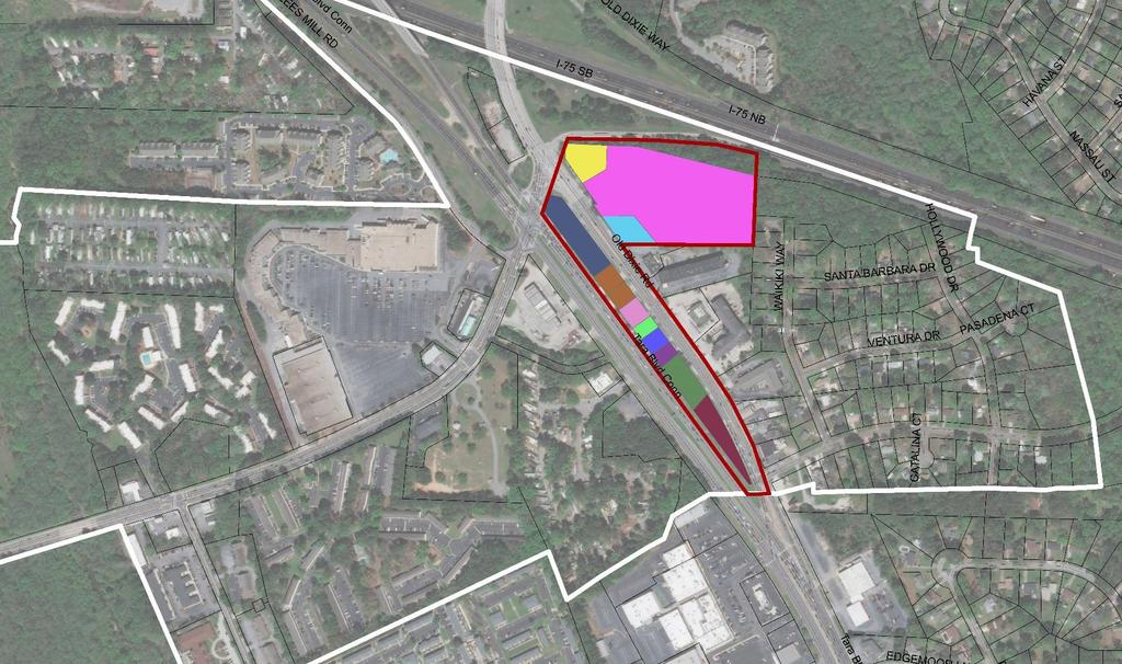
19 CONCET LAN: HASE 1 Retail Office Education Hotel Office with Retail Office Old Dixie hase 1: 11 Acres 12 arcels 11 roperty owners Residential Retail Residential

20 CONCET LAN: HASE 1
 No Max Density FAR: Minimum 1.")
21 ROOSED ZONING: MEDICAL DISTRICT OVERLAY Medical Office Mixed Use roposed Uses Medical Office Educational/Research Residential Retail Restaurant Hotel Fitness Greenspace Heights Minimum: 2 (with exceptions) No Max Density FAR: Minimum 1.0 Units/Acre: Minimum 15 Design Standards Streetscapes Architecture ublic Art
22 OLD DIXIE NEXT STES Short Term (100 day plan) Development Authority of Clayton County to approve this Master lan. resent plan to Clayton County Board of Commissioners and discuss next steps. Consider projects from this Master lan appropriate to include on the Clayton County SLOST list. Develop Old Dixie Overlay District with zoning updates, including incentives for development that meets the vision set forth in this master plan. Identify parcels to acquire, beginning with parcels included in hase 1. Leverage economic development incentives, including the existing Tax Allocation District, Tier 1 State Job Tax Credits, New Market Tax Credits, to attract redevelopment. Begin discussions with Clayton State University and other institutions regarding a satellite medical campus or Continuing and rofessional Education facility. Continue discussions with GDOT on the Old Dixie/Tara Boulevard intersection. ursue funding for a transportation study of intersection solutions. riority Long Term (1-5 years) Work closely with the Georgia Department of Transportation (GDOT) to realign the Old Dixie Road/Tara Boulevard intersection, per recommendations within this plan. Development Authority of Clayton County, in partnership with the County, to begin consolidating land, primarily parcels in hase 1. Design and develop Gateway ark. Enhance the Tara Boulevard and Old Dixie Road streetscapes, including wide sidewalks buffered from the road with plantings, street trees, street lights, and street post banners or flags welcoming drivers to Clayton County. As parcels are acquired and/or as private development occurs, regulate block size and streetscape design to develop the street grid per this master plan. This will provide developable parcels, while enhancing the desired walkability and connectivity. Attract a quality hotel to the study area. Coordinate with the AeroATL Greenway lan for trail connectivity and expansion, particularly along the Flint River.
23 THANK YOU!

24 MOUNTAIN VIEW-HASE 1: LAND OWNERS

25 OLD DIXIE-HASE 1: LAND OWNERS
Mountain View & Old Dixie Master Plans DACC Meeting. July 10, 2018
 Mountain View & Old Dixie Master Plans DACC Meeting July 10, 2018 Agenda I. Project Schedule II. Goals III. Design Workshop Our Team Sizemore Group: Award-Winning Planning and Architecture Principal: Bill
Comprehensive Plan Advisory Panel Meeting #3
 Comprehensive Plan Advisory Panel Meeting #3 November 7, 2016 Agenda 1. September 19 th Meeting Notes 2. Summary of Focus Areas Charrette 3. Heart of the City Focus Area a. HOC2/Station Areas Concept &
Point A Point B Point C Point D. City of Hapeville Public Meeting July 25, 2017
 City of Hapeville Public Meeting July 25, 2017 Fulton County Transit Master Plan Overview Following last year s ¾-cent TSPLOST effort, the Mayors of the 14 Cities outside of Atlanta and the Fulton County
The Private Role in a Public-Private Partnership. Ask Me Anything Conference May 30, 2018
 The Private Role in a Public-Private Partnership Ask Me Anything Conference May 30, 2018 1 Thoughts to Share Today Schmit+Associates Essential Elements of a P3 Community Vision Market Demand Economic Viability
Existing Conditions. Planning and Design Principles
 penn s south bank enn s South Bank is located south of the Schuylkill River at the intersection of 4th Street and. This acre former heavy industrial site offers the opportunity to accommodate a variety
The transportation system in a community is an
 7 TRANSPORTATION The transportation system in a community is an important factor contributing to the quality of life of the residents. Without a sound transportation system to bring both goods and patrons
Status Report: MD 355 Project
 Status Report: MD 355 Project OCTOBER 2006 M-NCPPC MONTGOMERY COUNTY PLANNING DEPARTMENT Summary of Community Comments, and break to the Results of the MD 355 Participation Session Brookside Gardens -
GPA FALL 2017 CONFERENCE
 Change in Doraville Doraville at the beginning of a new era Design Doraville (Comp. Plan) adopted in 2016 Doraville Town Center Masterplan LCI (2005) Downtown Doraville Masterplan LCI (2010) 2014 Adoption
Fort McPherson Master Plan
 Fort McPherson Master Plan Fort McPherson In 1885, Fort McPherson became the first permanent Army installation in the Southeast. Located on 488 acres in the City of Atlanta halfway between the airport
U T D N o r t h C a m p u s T O D and D o w n t o w n D e n t o n T O D
 U n i v e r s i t y o f T e x a s a t D a l l a s C i t y o f R i c h a r d s o n U T D N o r t h C a m p u s T O D and D o w n t o w n D e n t o n T O D Rick Leisner, AICP Assistant Director of Development
Corridor Vision. 1Pursue Minnehaha-Hiawatha Community Works Project. Mission of Hennepin County Community Works Program
 1Pursue Minnehaha-Hiawatha Community Works Project Minnehaha-Hiawatha Community Works is a project within the Hennepin Community Works (HCW) program. The mission of the HCW program is to enhance how the
NORTH CLAYMONT AREA MASTER PLAN COMMUNITY WORKSHOP #1 FEBRUARY 3, 2016
 NORTH CLAYMONT AREA MASTER PLAN COMMUNITY WORKSHOP #1 FEBRUARY 3, 2016 1. Introduction To the team and to the Plan Planning Partners The Claymont Community WILMAPCO New Castle County Claymont Renaissance
City of Lake Mary, Florida. Evolution of a Historic Downtown with Transit Oriented Development Strategies
 City of Lake Mary, Florida Evolution of a Historic Downtown with Transit Oriented Development Strategies What is Transit Oriented Development? Walkable villages located at and around transit stations in
The Five Components of the McLoughlin Area Plan
 The Five Components of the McLoughlin Area Plan This documents contains the complete language of the five components of the McLoughlin Area Plan: The Vision Statement The Values The Guiding Principles
Developer s Program. The Station at East 54
 Developer s Program The Station at East 54 Existing Conditions The Station at East 54 is proposed for a 1.12 acre site at the northeast corner of Hamilton Road and Prestwick Road, tucked between the East
17.11 Establishment of Land Use Districts
 17.11 Establishment of Land Use Districts 17.11.010 Purpose. To promote the health, safety, and general welfare of City residents and those who come to South Salt Lake to work, exchange commerce and recreate.
Atlanta BeltLine Subarea 3 Master Plan Update
 Atlanta BeltLine Subarea 3 Master Plan Update April 14, 2018 Workshop Meeting 1 22 miles, connecting 45 neighborhoods 22 MILES of transit 46 MILES of streetscapes and complete streets 33 MILES of urban
12/9/2013. HOLLYWOOD/PINES CORRIDOR PROJECT AMPO 2013 Annual Conference October 24, Our Perspective. Broward.
 HOLLYWOOD/PINES CORRIDOR PROJECT AMPO 2013 Annual Conference October 24, 2013 Our Perspective Broward Fort Lauderdale 1 Broward Metropolitan Planning Organization Fort Lauderdale Fort Lauderdale Skyline
Hopkins. Development Guidelines May Overview. Sponsored by: Blake Road Corridor Collaborative City of Hopkins
 Hopkins Blake Road LRT Station Area Development Guidelines May 2015 Sponsored by: Blake Road Corridor Collaborative City of Hopkins Overview Hopkins is a dynamic community of over 17,000 residents located
Downtown Dubuque...it s a great time.
 Downtown Dubuque...it s a great time. Your timing could not be better to invest in Downtown. With hundreds of millions in public and private investment occurring on the City s downtown waterfront, millions
Turcot: For a sustainable and active future
 Turcot: For a sustainable and active future Turcot: Pour un site actif et un développent durable This site offers one of largest undeveloped open space near a CBD in the country. Currently the location
Equitable Growth Through TOD Planning
 Equitable Growth Through TOD Planning Community Meeting # 2 November 2017 Goals Objectives Extend investment from downtown Connect neighborhoods physically and economically Enhance places based on local
FUTURE LAND USE ELEMENT
 FUTURE LAND USE ELEMENT GOAL I: To create and sustain a great place to live, play, and prosper Objective 1: The City of Ocala shall incorporate the principles and strategies of the Ocala 2035 Vision into
Implementation Guide Comprehensive Plan City of Allen
 Implementation Guide 2030 Comprehensive Plan City of Allen DRAFT 2015 Implementation Guide Allen 2030 Comprehensive Plan INTRODUCTION The Comprehensive Plan serves as a guide for the growth and development
Area Plans. September 18, 2012
 Area Plans September 18, 2012 Transfer ratio for existing development up to 1:6 depending on sending parcel sensitivity and distance from community centers and/or transit routes. Within Town Center and
Mountain View Master Plan
 Mountain View Master Plan SIZEMORE GROUP in association with NOELL CONSULTING and STANTEC Draft October 2018 Mountain View Master Plan Draft October 2018 SIZEMORE GROUP in association with NOELL CONSULTING
Commercial Node Plan Devine Street/Jackson Blvd. COLUMBIA, SC
 Commercial Node Plan Devine Street/Jackson Blvd. COLUMBIA, SC 9.17.13 AGENDA 1 Introductions 2 Project Update 3 Concepts 4 Recommendations 5 Next Steps Introductions Project Update Process 5-Phase Process
THE NEIGHBORHOOD TODAY
 THE NEIGHBORHOOD TODAY CORE AREA VISION How are we Good Urbanism A Site s DNA thinking about Elements of great Unique elements urban communities embedded in a place the site and design? ELEMENTS LIKE:
CHAPTER 7: Transportation, Mobility and Circulation
 AGLE AREA COMMUNITY Plan CHAPTER 7 CHAPTER 7: Transportation, Mobility and Circulation Transportation, Mobility and Circulation The purpose of the Transportation, Mobility and Circulation Chapter is to
CHARLES PUTMAN CHARLES PUTMAN AND ASSOCIATES, INC
 MEMORANDUM CHARLES PUTMAN & ASSOCIATES, INC. LAND DEVELOPMENT CONSULTANTS PLANNING ZONING PERMITTING 4722 NW Boca Raton Boulevard, Suite C-106 Boca Raton, Florida 33431 Phone: 561/994-6411 FAX: 561/994-0447
Gorman Neighbourhood Structure Plan LDA WELCOME RESIDENTS. edmonton.ca/gormanneighbourhoodplan. CITY OF EDMONTON Sustainable Development
 Gorman Neighbourhood Structure lan WELCOME RESIDENTS Gorman Neighbourhood Structure lan AGENDA & CONTACT INFO Tonight s Agenda City of Edmonton File lanner Information Sarah Ramey, File lanner Registration
THE 355/270 CORRIDOR:
 THE 355/270 CORRIDOR: Strategic Ideas for Sustaining a Livable Work Place Project Summary ACCESS LIFE DESIGN HEALTH WORK Montgomery County Planning Department The Maryland-National Capital Park and Planning
RE-Imagining the Downtown Colorado Springs Master Plan
 RE-Imagining the Downtown Colorado Springs Master Plan 2016 APA Colorado State Conference October 25, 2016 Overview 8:00 Welcome, Introductions, and Overview 8:15 Downtown s Planning History 8:30 A Market
Transportation. Strategies for Action
 Transportation A major priority for the Overlake Neighborhood is to develop a multimodal transportation system. To achieve this system, a balance has to be found among travel, circulation and access needs;
March 14, :30 p.m.-city Hall
 March 14, 2012 6:30 p.m.-city Hall Board of Mayor and Commissioners (BOMC) Citizens, Property and Business Owners Planning and Zoning Board (P&Z) Downtown Development Authority (DDA) Architectural Review
greenprint midtown SUSTAINABILITY ACTION PLAN 2012
 greenprint midtown SUSTAINABILITY ACTION PLAN 2012 MIDTOWN ALLIANCE SOUTHFACE ENERGY INSTITUTE RENAISSANCE PLANNING GROUP SUSTAINABLE ATLANTA PERKINS+WILL 2 GREENPRINT MIDTOWN 1. Introduction Sustainability
Gold Line Bus Rapid Transit Transit Oriented Development (BRTOD) Helmo Station Area Plan
 Helmo Station Area Plan") Appendix F Gold Line Bus Rapid Transit Transit Oriented Development (BRTOD) Helmo Station Area Plan Introduction and Purpose of the Plan The Gold Line Bus Rapid Transit facility is an eleven-mile dedicated
Appendix F Gold Line Bus Rapid Transit Transit Oriented Development (BRTOD) Helmo Station Area Plan Introduction and Purpose of the Plan The Gold Line Bus Rapid Transit facility is an eleven-mile dedicated
City of Tacoma Planning and Development Services
 Agenda Item E-1 City of Tacoma Planning and Development Services To: Planning Commission From: Elliott Barnett, Planning Services Division Subject: Tacoma Mall Regional Center Subarea Plan and EIS Meeting
A. WHAT IS A GENERAL PLAN?
 I. Introduction A. WHAT IS A GENERAL PLAN? A general plan is the planning guideline for the future of a city. It contains goals and policies which regulate urban development, the protection of the natural
Atlanta BeltLine, Inc. Pathways to Urban Sustainability
 Atlanta BeltLine, Inc. Pathways to Urban Sustainability September 30, 2010 WHAT IS THE ATLANTA BELTLINE? Transit 22-mile loop Parks 1300 + new acres Trails 33 miles Jobs & Economic Development 20 areas,
KCATA Transit Oriented Development Initiatives
 KCATA Transit Oriented Development Initiatives KCATA: Regional Transportation Authority Created by bi-state compact Approved by Congress 7 County service area Quasi-governmental with broad powers Power
Robbinsdale LRT Station. CDI Development Guidelines. August Overview
 Robbinsdale LRT Station August 2018 Overview The City of Robbinsdale may have the coolest opportunity site along the 13 mile stretch of the Bottineau LRT corridor / Blue Line extension. Located a block
Taming Tysons Corner Transforming the Quintessential Edge City
 Taming Tysons Corner Transforming the Quintessential Edge City Transit is the greatest catalyst for change at Tysons, but how do we take advantage of this billion-dollar investment? If transit is built
DRAFT ROOSEVELT ROAD. District Recommendations. Figure 5.23 The Roosevelt Road Corridor
 CHAPTER 5 Figure 5.23 The Road Corridor Road will develop as a mixed-use corridor, emphasizing regional retail, west of the river and mixed-use development east of the river. KEY RECOMMENDATIONS 1. High
NACCED/NACo CONFERENCE JULY 10, 2015
 NACCED/NACo CONFERENCE JULY 10, 2015 Regional Growth Framework 2 Regional Growth Framework Regional Priorities Preferred Growth Concept Tools to Support Local Governments 3 Top Priorities for the CONNECT
Planning Districts INTRODUCTION
 INTRODUCTION To facilitate detailed examination of development prospects for all areas of the community, Delano has been divided into 14 planning districts. The location of these planning districts is
New Partners for Smart Growth Conference February 5, 2010
 Dan Stroh, Planning Director City of Bellevue Planning and Community Development Bellevue, WA New Partners for Smart Growth Conference February 5, 2010 Summary of Project Long-range plan update for Bel-Red
INDEPENDENCE BOULEVARD AREA PLAN
 INDEPENDENCE BOULEVARD AREA PLAN Public Meeting October 28, 2008 Tonight s Agenda Introduction 4:00 4:05 Tom Warshauer Presentation 4:05 5:00 Blake Drury Group Exercises 5:00 5:50 All Wrap Up & Next Steps
DRAFT PLAN PRESENTATION
 DRAFT PLAN PRESENTATION 1.23.2018 AGENDA Process Project Schedule Results from Visioning Workshop Draft Plan Highlights Concept Plans Feedback Next Steps PROJECT SCHEDULE KICK-OFF WORKSHOP August 29 th
West Kendall Corridor June 11, 2014
 June 11, 2014 Miami-Dade County Department of Regulatory and Economic Resources Development Services Division ā 1 Presentation Outline Review Study Area Review of Citizens Plans and Presentations Planning
Cobb County Design Guidelines Mableton Parkway & Veterans Memorial Highway Community Design Workshop January 12, 2017
 Community Design Workshop January 12, 2017 Agenda Opening Remarks / Introductions Scope of Work Existing Conditions Key Issues / Opportunities VPS Summary Draft Vision & Goal Statement Implementation Concepts
PINE CURVE REZONING. BACKGROUND Purchased as two parcels in 2001 and 2002
 BACKGROUND Purchased as two parcels in 2001 and 2002 WHAT THE PROJECT IS AND IS NOT A Rezoning establishes the land use standards for Annexed and Zoned Greater Downtown District Historic Center September
Atlanta BeltLine. Subareas 9 & 10. Master Plan Updates. March 26, Washington Park Jamboree 1
 Atlanta BeltLine Subareas 9 & 10 Master Plan Updates March 26, 2018 Washington Park Jamboree 1 22 miles, connecting 45 neighborhoods 22 MILES of transit 46 MILES of streetscapes and complete streets 33
Lower Merion Commercial Districts Issues and Characteristics Handbook November 2013
 Lower Merion Commercial Districts Issues and Characteristics Handbook November 2013 DRAFT TOWNSHIP-WIDE VISION: To maintain and enhance commercial areas to complement the surrounding high-quality residential
REGIONAL ACTIVITY CENTER
 DRAFT REGIONAL ACTIVITY CENTER 70 EAST BENCH MASTER PLAN DRAFT 06 Introduction The East Bench Regional Activity center is comprised of large educational, research, medical, and employment centers. These
Draft Plan Recommendations
 Draft Plan Recommendations Sponsored by Henry County and the Atlanta Regional Commission T S W TEAM Tunnell-Spangler-Walsh & Associates URS Corporation Marketek Study Area 1,300 acres Includes parts of
Planning Area & Context. Planning Goals. 1. Improve circulation and traffic. 2. Increase mutual trust and benefits
 Planning Area & Context Planning Goals 1. Improve circulation and traffic 2. Increase mutual trust and benefits 3. Design integrated streets/ buildings 4. Provide housing and mixed-uses 5. Create and enhance
C. Westerly Creek Village & The Montview Corridor
 C. Westerly Creek Village & The VISION Community Vision When the goals of the city are achieved Westerly Creek Village, a distinctive community defined by Montview Boulevard and Westerly Creek, is a strong
New Town Mixed Use District
 New Town Mixed Use District Montgomery County Planning Commission 2009 Annual Conference PA Chapter of the American Planning Association October 6, 2009 What is NTMU? More urban style of development Complementary
Town Center (part of the Comprehensive Plan)
") Town Center (part of the Comprehensive Plan) Mercer Island Town Center Looking North (2014) In 1994, a year-long process culminated in a set of design guidelines and code requirements for the Town Center
Town Center (part of the Comprehensive Plan) Mercer Island Town Center Looking North (2014) In 1994, a year-long process culminated in a set of design guidelines and code requirements for the Town Center
Executive Summary. NY 7 / NY 2 Corridor
 Executive Summary NY 7 / NY 2 Corridor Transportation and Land Use Study December 2005 Prepared for: Town of Colonie Capital District Transportation Committee Prepared by: Introduction: Land use decisions
FUTURE DEVELOPMENT AREAS
 FUTURE DEVELOPMENT AREAS Refer to the Future Development Map on Page 2. Suburban Residential (Less than 3 units/acre) Suburban Residential neighborhoods form the backbone of Smyrna. While growth and redevelopment
Stakeholders Advisory Working Groups (SAWGs) Smart Growth and TOD Land Use (#11) SAWG Meeting
 Smart Growth and TOD Land Use (#11) SAWG Meeting") Presentation - Part II Tappan Zee Bridge/I-287 Corridor Project July 21, 2010 Slide 1. David Kooris (Regional Plan Association) welcomed members of the Land Use Stakeholders Advisory Working Groups (SAWGs)
Presentation - Part II Tappan Zee Bridge/I-287 Corridor Project July 21, 2010 Slide 1. David Kooris (Regional Plan Association) welcomed members of the Land Use Stakeholders Advisory Working Groups (SAWGs)
Affordability & Equity
 Affordability & Equity 1. Impact Fees 2. Displacement Prevention- build more housing to meet growth demands 3. Density Bonuses 4. Regional Housing Bond 5. Stricter Condominium Conversion Laws 6. Vacant
Port Lavaca Future Land Use
 Port Lavaca Future Land Use Introduction The City of Port Lavaca is beginning to see sustained growth, after many years of relative stable population. New single family homes, apartments, and businesses
A BLUEPRINT FOR BROCKTON A CITY-WIDE COMPREHENSIVE PLAN
 A BLUEPRINT FOR BROCKTON A CITY-WIDE COMPREHENSIVE PLAN Public Meeting October 2016 1 Plan Summary and Discussion Public Meeting May 4 2017 City of Brockton Bill Carpenter, Mayor Department of Planning
CID S The Future Unveiled. Community Improvement Districts
 CID S The Future Unveiled Community Improvement Districts Many, if not all of us in the room know the role and understand the value CID s add to Metro Atlanta. These centers of influence are dramatically
Today Land & People. Northeast Nampa Gateway District. Employment. Land Use Characteristics. Demographics. Current Zoning
 Today Land & People Employment Major employers include Saint Alphonsus, the College of Western Idaho, the Auto Mall, Sorrento Lactalis and Walmart. 3,004 jobs in 2010 (COMPASS-CIM 2040 TAZ data) 4,345
ROBBINSDALE LRT STATION CDI DEVELOPMENT GUIDELINES
 August 2018 OVERVIEW The City of Robbinsdale has a prime-opportunity site in the middle of the 13 mile stretch of the Bottineau LRT corridor / Blue Line extension. Robbinsdale offers a prominent, vital,
COMMUNITY IMPROVEMENT DISTRICTS
 MASTER PLAN EXECUTIVE SUMMARY May 11, 2017 TWO DISTRICTS, ONE APPROACH The Aerotropolis Atlanta Community Improvement In January 2016 the leaders of the two CIDs decided Districts is a combination of the
Ivywild On The Creek PRELIMINARY CREEK DISTRICT MASTER PLAN
 Ivywild On The Creek PRELIMINARY CREEK DISTRICT MASTER PLAN Introduction: Rejuvenating an extraordinary Creekside neighborhood THE CREEKSIDE DISTRICT The Ivywild On The Creek Neighborhood District Master
124 Subarea Visions. Vision Plan. A. Nelessen Associates, INC I Visioning I Planning I Urban Design
 Subareas 124 Subarea Visions The next seven sections describe specific recommendations tailored to each subarea. Each subarea is discussed separately except for certain aspects of 95th Street and Antioch
DRAFT Civic Center Station Area Plan. Executive Summary
 DRAFT Civic Center Station Area Plan Executive Summary This project is funded in part through the Metropolitan Transportation Commission s Station Area Planning Program. The preparation of this report
Subareas 9 & 10 Master Plan Updates
 Atlanta BeltLine Subareas 9 & 10 Master Plan Updates Study Group Meeting 4 September 17, 2018 Washington Park Jamboree 1 22 miles, connecting 45 neighborhoods 22 MILES of transit 46 MILES of streetscapes
THE TOWN OF WASAGA BEACH
 THE TOWN OF WASAGA BEACH Downtown Development Master Plan Committee of the Whole Presentation January 26 th 2017 Uses within this designation should reflect a dependence on tourism as opposed to the permanent
2036 Comprehensive Plan Community Agenda Volume 1 of 3 Community Assessment Volume 2 Technical Appendix Volume 3
 SMALL-TOW N ATMOSPHERE PARKS & TRAILS TOURISM CENTER 2036 Comprehensive Plan Community Agenda Volume 1 of 3 Community Assessment Volume 2 Technical Appendix Volume 3 TRADITIONAL NEIGHBORHOODS REGIONAL
ELMVALE ACRES SHOPPING CENTRE MASTER PLAN
 ELMVALE ACRES SHOPPING CENTRE MASTER PLAN Contents 1.0 INTRODUCTION... 2 2.0 LOCATION... 2 3.0 EXISTING CONTEXT... 2 4.0 VISION & GUIDING PRINCIPLES... 2 5.0 LAND USE AND BUILT FORM... 4 5.1 St. Laurent
2.0 THE PLATINUM TRIANGLE VISION
 2.0 THE PLATINUM TRIANGLE VISION The envisions an exciting future for the area surrounding Angel Stadium of Anaheim, the Honda Center and The Grove of Anaheim. 2.1 Planning Principles In order to further
SLIDE TITLE TRANSIT-ORIENTED DEVELOPMENT PLAN RED-PURPLE BYPASS STUDY AREA PUBLIC MEETING #2 RED AND PURPLE MODERNIZATION. RPM TOD Plan Update
 SLIDE TITLE TRANSIT-ORIENTED DEVELOPMENT PLAN RED-PURPLE BYPASS STUDY AREA PUBLIC MEETING #2 RED AND PURPLE MODERNIZATION 1 SLIDE TITLE AGENDA Project Introduction TOD s and Development Trends Real Estate
CONTEXT: the Highway, the River + the Railroads run through us.
 CONTEXT: the Highway, the River + the Railroads run through us. I-25 36 In the past they have divided us, now we have an opportunity to unite us. I-76 I-270 I-76 CSU I-25 LEGEND Cut + Cover River North
CITY OF NORCROSS LILLIAN WEBB PARK REDEVELOPMENT AREAS
 7/2/2016 CITY OF NORCROSS LILLIAN WEBB PARK REDEVELOPMENT AREAS 2016 Potential Development Around Lillian Webb Park The Lillian Webb Park Development Project is located north of Buford Highway; east of
A P P E N D I X B - O P P O R T U N I T Y S I T E S
 A P P E N D I X B - O P P O R T U N I T Y S I T E S OPPORTUNITY SITES As listed in the Land Use Element, the City has identified 15 Opportunity Sites expected to be the focus of change and revitalization
Small Area Plan. South Gateway
 Small Area Plan Adopted May 12, 2008 South Gateway Purpose. The South Gateway Small Area Plan defines the City s expectations for the future of the southern entrance to the City at Interstate 85 and Highway
City of Long Beach. creating vibrant and exciting places
 City of Long Beach creating vibrant and exciting places Land Use Element Urban Design Element Overview of the two draft General Plan elements Discuss areas of change Economic goals of the plans Case study
City of Farmington. Downtown Plan. Amendment to the 1998 Master Plan Adopted October 11, 2004
 City of Farmington Amendment to the 1998 Master Plan Adopted October 11, 2004 Introduction Planning Background 1 Scope and Components of the Plan Amendment 2 Concept Introduction 3 Plan Concepts 3 Conceptual
Developer Panel Summary Report
 December 17, 2013 Developer Panel Summary Report Richton Park, IL Prepared by: Introduction The Regional Transportation Authority (RTA) has invested over $4 million of its own funds and leveraged over
D-O LRT Zoning Discussion. Chapel Hill Boards & Commissions October 16, 2017
 D-O LRT Zoning Discussion Chapel Hill Boards & Commissions October 16, 2017 Update on Overall D-O LRT Station Area Initiative Objectives Design and educate on principles of Good Transit-Oriented Development
Northwest commuter rail station US 36 BRT. Westminster Station
 Northwest commuter rail station Westminster Station US 36 BRT Westminster Center US 36 & Church Ranch Broomfield Flatiron/96 th St. US 36 & McCaslin Table Mesa Boulder Junction 13-month effort that will
Table of Contents. Elm Avenue Improvement Plan City of Waco, Texas. Introduction 1. Existing Context 1 Figure 1 2.
 Table of Contents Introduction 1 Existing Context 1 Figure 1 2 Plan Guidelines 3 Future Urban Form 4 The West-End 4 Main Street 6 The East-End 7 Figure 2 9 Public Improvement Recommendations 7 General
A larger version of this map is located on the last page of this PDF.
 MAP Committee Input McLoughlin Area Draft Vision Map A larger version of this map is located on the last page of this PDF. 1. The map above is intended to portray a vision for the McLoughlin area. It highlights
4 LAND USE DESIGNATIONS
 4 LAND USE DESIGNATIONS Chapter 4 describes the land use designations and densities that will implement the development vision for North Burlingame outlined in Chapter 3. Land use densities are described
BeltLine Corridor Environmental Study
 BeltLine Corridor Environmental Study Citywide Conversation on Transit and Trails April 2, 2009 Agenda & Introductions Introductions Environmental Study Process Overview of the BeltLine Project BeltLine
Buckhead Pedestrian Connectivity Study. Buckhead Community Improvement District
 Buckhead Pedestrian Connectivity Study Buckhead Community Improvement District April 2011 Prepared for: The Buckhead Community Improvement District Prepared by: In association with: Cooper Carry, Inc.
The Lower SaLuda Greenway
 The Lower SaLuda Greenway InITIaTIve a FLourIShInG Greenway. a hub For economic GrowTh. a ConneCTIon BeTween CoMMunITIeS. In April 2017 the Michael J. Mungo Foundation and Lexington County commissioned
Seneca Meadows. Block 4 Locate office, technology, and medical development adjacent to I Screen views of garage structures from I-270.
 Seneca Meadows Seneca Meadows has an industrial park in its southern end and a mixed-use employment area planned for the north end. The district benefits from extensive I-270 visibility, stream valley
West Ocala Vision & Community Plan City Council Work Session. Presented by West Ocala Community Plan Steering Committee
 West Ocala Vision & Community Plan City Council Work Session Presented by West Ocala Community Plan Steering Committee November 29,2011 Ocala 2035 Vision West Ocala Community Vision & Master Plan West
Environmental: Urban land..51 acre wet (.30%); 1.01 acres/.59% within a 100 year floodplain; no other environmental indicators limit development.
; 1.01 acres/.59% within a 100 year floodplain; no other environmental indicators limit development.") A N DOV ER Downtown: Designated a State PDA Land Use: Downtown Andover (171.61 acres) is the Town s traditional central business district. It consists of offices, shops, restaurants, civic and institutional
A N DOV ER Downtown: Designated a State PDA Land Use: Downtown Andover (171.61 acres) is the Town s traditional central business district. It consists of offices, shops, restaurants, civic and institutional
What Pioneer Grove Will Look Like?
 The City of Deerfield Beach has embarked on a journey to create a new town center within the old heart of Deerfield Beach. The new town center is known as Pioneer Grove. Pioneer Grove will be Everybody
4.1.3 LAND USE CATEGORIES
 4.1.3 LAND USE CATEGORIES a. City Center District The City Center District incorporates the existing character and mix of uses in downtown Belmont to encourage redevelopment and new development in keeping
REPORT TO PLANNING COMMISSION City of Sacramento
 REPORT TO PLANNING COMMISSION City of Sacramento 915 I Street, Sacramento, CA 95814-2671 3 PUBLIC HEARING September 23, 2010 Members of the Planning Commission Subject: Florin Road Corridor Plan - Policies