TRAFALGAR ROAD
|
|
|
- Amos Snow
- 5 years ago
- Views:
Transcription


1 TRAFALGAR ROAD URBAN DESIGN BRIEF PREPARED BY KLM PLANNING PARTNERS INC. FOR DUNPAR DEVELOPMENTS INC. TOWN OF OAKVILLE JUNE 2012

2 TABLE OF CONTENTS 1 INTRODUCTION 1.1 Project Description Subject Lands Purpose Site Analysis Existing Conditions Surrounding Context Neighbourhood Character Transportation Facilities Opportunities & Constraints Goals & Objectives Compliance with Town Policies Land Use Policies Urban Design Policies DESIGN CONCEPT 3.1 Site Design Built Form Elements & Massing Building Articulation & Architectural Treatment Character & Image Lighting Sustainability Public Realm IMPLEMENTATION 64 JARDIN DRIVE, UNIT 1B CONCORD, ON L4K 3P3 TEL: (905) FAX: (905)

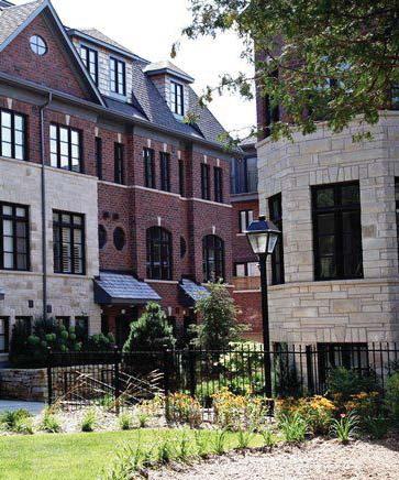
3 1 INTRODUCTION 1.1 PROJECT DESCRIPTION KLM Planning Partners Inc. has been retained by Dunpar Developments Inc. to prepare this brief as part of the supporting document submission package for the proposed development of 114 residential townhomes on Trafalgar Road in the Town of Oakville Subject Lands The subject lands are legally described as Part of Lot 13, Concession 1, South of Dundas Street (Geographic Township of Trafalgar) and are known municipally as 2158, 2168, 2180, and 2192 Trafalgar Road, in the Town of Oakville. They are 1.65 hectares in size, and have an approximate frontage of 166 metres along Trafalgar Road (see Figure 1.2). Topographically, the site is generally fl at Purpose The purpose of this Urban Design Brief is to provide a detailed description of the development proposal, an analysis of the local context, and a discussion on how the proposed development was devised to be consistent with Town s urban design policies, as well as compatible with the character of the existing community. FIGURE 1.1: EXAMPLE OF DUNPAR DEVELOPMENT IN MISSISSAUGA 1

4 1 INTRODUCTION SUBJECT LANDS FIGURE 1.2: LOCATION MAP 2


. They have a combined")


5 2.1 SITE ANALYSIS Existing Conditions In their current form, the subject lands are comprised of four (4) individual rural residential lots known municipally as 2158, 2168, 2180, and 2192 Trafalgar Road (see Figure 2.1). They have a combined area of 1.65 hectares, and have an approximate total frontage of 166 metres along Trafalgar Road. Topographically, the site is generally fl at. Each Lot contains a single dwelling, with the exception of number 2180, which currently sits vacant. Driveway access to each lot is provided individually and directly onto Trafalgar Road TRAFALGAR ROAD 2158 TRAFALGAR ROAD 2168 TRAFALGAR ROAD FIGURE 2.1: SUBJECT LANDS 2180 TRAFALGAR ROAD 2192 TRAFALGAR ROAD 3

6 2.1.2 Surrounding Context North: Immediately to the north of the subject lands is a multi-tenant commercial building with professional offi ces including a daycare centre, chiropractic and dental offi ce. These lands are designated as Neighbourhood Commercial in the Offi cial Plan. Further to the north is the Uptown Core, comprised of a mix of commercial retail and medium to high density residential uses - including a neighbourhood park. East: Across Trafalgar Road to the east of the subject lands is an established residential neighbourhood, consisting mostly of single detached dwellings. Some of these dwellings fronting onto a window street abutting Trafalgar Road. South: To the south are single dwellings situated on original rural lots, as well as two Catholic Churches located on the north and south sides of River Oaks Boulevard. SUBJECT LANDS FIGURE 2.2: CONTEXT PLAN West: To the west are currently vacant lands, approved for the development of 52 single detached dwellings through Draft Plan of Subdivision 24T


7 2.1.3 Neighbourhood Character The subject lands are situated directly on the Trafalgar Road corridor, which has been identifi ed as a future rapid transit corridor with the potential for new growth by means of intesifi cation. However, they are also adjacent to stable residential neighbourhoods, and other existing land uses. This section of the Trafalgar Road corridor is transitional in nature, which is refl ected in the mixture of housing types and densities present. The overall character of this area is generally low density, however new development in the Uptown Core is spawning a change in the local development pattern to higher densities. As the Uptown Core continues to develop, it is expected that the Trafalgar Road corridor will grow in a similar fashion, and evolve into a true urban streetscape with built form at a pedestrian scale and densities that are also transit supportive. 1 RESIDENTIAL APARTMENTS AND HIGHER DENSITIES OF THE UPTOWN CORE 3 NEIGHBOURHOOD PARK ON GLENASHTON DRIVE 2 PROFESSIONAL OFFICES ON TRAFALGAR ROAD 4 1 MULTIPLE ATTACHED DWELLINGS LOCATED ON GLENASHTON DRIVE EXISTING RESIDENTIAL FRONTING ONTO A WINDOW STREET NEW UKRAINIAN CATHOLIC CHURCH 5


8 2.1.4 Transportation Facilities Trafalgar Road is considered as a major arterial, and provides direct north-south connections to other major throughfares, such as the QEW and Highway 407, as well as major transit facilities such as the Oakville Go station. Collector streets bisect Trafalgar Road at regular intervals, providing local vehicular and pedestrian connections to the existing residential areas. Oakville Transit currently serves this section of Trafalgar Road via Route #1, traveling from the Oakville GO station to the Uptown Core Terminal. Route #19 is also within close proximity to the subject lands, and offers a rush hour express service (as Route #190) to and from the Oakville GO Station. Bus stops are currently located at the intersections of Glenashton Drive and River Oaks Boulevard on both sides of Trafalgar Road. SUBJECT LANDS FIGURE 2.3: EXSITING TRANSIT FACILITIES 6


 FUTURE DEVELOPMENT (UPTOWN CORE) GLENASHTON DRIVE B B TRAFALGAR ROAD B CONSTRAINTS RIVER")

9 2.2 OPPORTUNITIES & CONSTRAINTS The size, location, and confi guration of the subject lands provide for a number of opportunities and limitations that have shaped the development of the overall concept: OPPORTUNITIES Located directly on existing public transit routes; Direct access to future planned rapid transit on Trafalgar Road; Frontage onto major arterial street; Pedestrian and vehicular connections to proposed approved subdivision adjacent to subject lands; Close proximity to existing community amenities, such as local commercial uses and places of worship; Potential connection to green space through approved subdivision adjacent to subject lands; Transitional nature of surrounding area encourages redevelopment and intensifi cation; Topography of site is generally fl at. FUTURE DEVELOPMENT (24T-06004) FUTURE DEVELOPMENT (UPTOWN CORE) GLENASHTON DRIVE B B TRAFALGAR ROAD B CONSTRAINTS RIVER OAKS BOULEVARD B No direct vehicular access onto Trafalgar Road. SUBJECT LANDS MAJOR ROAD LOCAL ROAD GREENWAY / OPEN SPACE B EXISTING TRANSIT ROUTE EXISTING BUS STOP FUTURE RAPID TRANSIT PEDESTRIAN ACCESS REDEVELOPMENT POTENTIAL FIGURE 2.4: SWOT PLAN COMMUNITY/COMMERCIAL ACTIVITY EXISTING DWELLING STREET FRONTAGE 7

10 2.3 GOALS AND OBJECTIVES The goal of the proposed development is to create a transitsupportive residential community that implements the Province s, Region s and Town s policies for intensifi cation, is compatible with the surrounding community fabric, and creates a high quality urban streetscape on Trafalgar Road. To achieve this goal, the following design objectives will be applied: Provide a building type massing that is pedestrian scaled, yet dense enough to support public transit use; Site buildings to frame street edges, both internal and external to the site; Create a consistent massing and appearance along frontages of the site; Locate buildings to screen parking areas from the streetscape; Encourage pedestrian movement by providing direct and convenient connections; Incorporate architectural elements that add visual interest to the street edge; and, Provide consistent and high quality landscaping along street frontages that will offer a comfortable and attractive pedestrian environment. 8


11 2.4 COMPLIANCE WITH TOWN POLICIES Livable Oakville is the Town s new Offi cial Plan for all lands south of Dundas Street and the lands north of Highway 407. It was approved on May 10, 2011, by the Ontario Municipal Board (OMB), with further modifi cations approved on August 4 and October 28, 2011 accordingly Land Use Policies The subject lands are currently designated Low Density Residential, as identifi ed on Schedule I of the Offi cial Plan, which permits the development of detached, semidetached and duplex dwellings at a density of up to 29 units per site hectare. An amendment to the Offi cial Plan is being requested to redesignate the subject lands from Low Density Residential to Medium Density Residential with a maximum density of up to 70 units per site hectare. Intensifi cation within stable residential communities is permitted under the Offi cial Plan, as outlined under Section (b), and To maintain and protect the existing neighbourhood character, this section outlines the criteria to evaluate the compatibility of new development within stable residential areas, including but not limited to the following: a) The built form of development, including scale, height, massing, architecturalcharacter and materials, is to be compatible with the surrounding neighbourhood; PLACEHOLDER TO TO BE BE UPDATED UPDATED FIGURE 2.5: OFFICIAL PLAN 9
12 b) Development should be compatible with the setbacks, orientation and separation distances within the surrounding neighbourhood; c) Where a development represents a transition between different land use designations or housing forms, a gradation in building height shall be used to achieve a transition in height from adjacent development; d) Where applicable, the proposed lotting pattern of development shall be compatible with the predominant lotting pattern of the surrounding neighbourhood; h) Impacts on the adjacent properties shall be minimized in relation to grading, drainage, location of service areas, access and circulation, privacy, and microclimatic conditions such as shadowing; j) Development should maintain access to amenities including neighbourhood commercial facilities, community facilities including schools, parks and community centres, and existing and/or future public transit services. The proposed development of 4-storey townhouses is consistent with these policies by providing a built form that is compatible with the surrounding detached dwellings. It provides an appropriate transition to adjacent and nearby 2-storey dwellings, and does not impose any signifi cant negative impacts such as shadowing and privacy. The site design also provides direct access to neighbourhood facilities, such as schools, places of worship, parks and local retail. Additionally, transit-supportive densities are incorporated along Trafalgar Road, which is identifi ed as a corridor linking the Midtown Oakville growth centre and Uptown Core in the Livable Oakville Offi cial Plan. It is defi ned under Section : Corridors are recognized for their potential for intensifi cation due to their location along major transit routes, and in many cases, because they contain numerous vacant or underutilized lands. 10

13 2.4.1 Urban Design Policies Section 6 of the Livable Oakville Offi cial Plan, outlines the town-wide urban design policies. It describes the Town s goal of acheiving a high standard of urban design and architecture to provide an innovative and diverse urban form that promotes a sustainable, dynamic and livable enviornment, which are achieved through the following objectives: To provide diversity, amenity, comfort, safety, and compatibility with the existing community; To encourage attractive and safe public spaces, such as streetscapes, gateways, vistas and open spaces; To promote innovative and diverse urban form and excellence in architectural design; and, To promote the creation of distinctive places and locales. These are achieved through a comprehensive evaluation of the following urban design elements. Under Section 6.2.7, the Public Realm policies state that new development should contribute to the creation of a cohesive streetscape through: The placement of building entrances towards the street; and, A variation of facade articulation and details; FIGURE 2.6: EXAMPLE OF FACADE ARTICULATION In order to acheieve compatibility with adjacent uses, new development should be designed to create an appropriate transition through the provision of roads, landscaping, spatial separation and compatible built form; as stated in Section

14 Additionally, the Built Form policies in Section state that buildings should align with neighbouring buildings for the purpose of creating a continuous streetwall, and providing comfort for pedestrians at ground level. The proposed development will create a cohesive streetscape along Trafalgar Road and the newly approved public road by orienting the townhouse blocks along the streetline. Variations in the design of the building elevations, including details such as gables, covered building entrances, and raised landscape planters, will provide added interest to the streetscape. As it relates to site Access and Circulation, Section states that defi ned internal driving aisles should be provided to establish on-site circulation, direct traffi c and frame parking areas. It also states that walkways should be provided through the site to connect pedestrians to building entrances, the public sidewalk, other pedestrian routes, adjacent developments, and transit facilities. Driveway entrances are also encouraged to minimize disruption of the public sidewalk. Two consolidated driveway entrances located on the approved future public street will provide access to the entire development. Internally, a private street network will provide vehicular access, and will be coupled with sidewalks to maximize pedestrian connectivty across the site. FIGURE 2.7: EXAMPLE OF A COHESIVE STREETSCAPE 12

15 Additionally, Landscaping is encouraged under Section to enhance the overall visual appearance of the development, promote a human scale and create an attractive pedestrian environment. It can also be used to frame desired views and defi ne various functions within the site, such as public open space. Planter boxes, covered entrances and street trees will be incorporated along the frontage of each townhouse block; which will achieve the goal of creating an attractive, humanscaled and comfortable streetscape. Section 6.10 states that surface Parking areas should be located in either rear or side yards and appropriately screened when visible from the street. Private resident parking will be provided at the rear of each townhouse block, accessed by lanes within the internal street network. Visitor parking will be provided at the side yard of some units, while most will be provided as parallel spaces to become part of the urban streetscape. Lastly, the Signage and Lighting policies of section state that adequate pedestrian-scaled lighting to accent walkways, steps, ramps, transit stops and other features should be provided. To achieve this, pedestrian-scaled lighting will be provided along the entirety of the internal street network, as well as all pedestrian walkways and private open spaces. FIGURE 2.8: EXAMPLE OF APPROPRIATE LANDSCAPING 13
16 3.1 SITE DESIGN The proposal consists of eleven (11) 4-storey townhouse blocks, totalling 114 units. The townhouse blocks will be sited to address the street frontages, and will provide direct pedestrian access to the street and public transit facilities. They will also frame private open spaces, and internal mews that will enhance the pedestrian realm of the proposed development. Private parking areas will be provided at the rear of the townhouse blocks and will be screened from the street, while most visitor parking will be provided as parallel spaces adding to the effect of the urban streetscape within the site. However, due to site restrictions a traditional townhouse block will be incorporated at the northwest corner of the site, with driveway and garage access provided along the front elevation. TRAFALGAR ROAD An internal private street system and sidewalks will accomodate pedestrian connections across the site to a future public street, as well as provide local vehicular access. No vehicular access is provided directly onto Trafalgar Road. APPROVED LOCAL ROAD DESIGN CONCEPT 3 PUBLIC STREET TRANSIT ROUTE PRIVATE ROAD PRIVATE PARKING VISITOR PARKING PEDESTRIAN ACCESS BUILDING FRONTAGE OPEN SPACE FIGURE 3.1: CONCEPT PLAN 14


17 3 DESIGN CONCEPT 3.2 BUILT FORM ELEMENTS & MASSING The proposed townhouse buildings are 4-storeys in height, however the roof design, which includes the use of dormers and gables to mask the fourth storey, creates the appearance of a 3-storey building. This provides an approproate transition towards the surrounding low-rise 2-storey dwellings. Building are set back to frame the street edge. Combined with covered entrances, landscaping, and street trees to delineate the private and public realm this treatment provides a comfortable pedestrain scale along the streetscape (see Figure 3.2). FIGURE 3.2: EXAMPLE OF URBAN STREETSCAPE FIGURE 3.3: TYPICAL ELEVATION 15


18 3 DESIGN CONCEPT 3.3 BUILDING ARTICULATION & ARCHITECTURAL TREATMENT In addition to the location of the proposed buildings along the street edge, the exterior design of the building plays an important role in creating a pedestrian scaled streetscape. To achieve this, the following design treatments have been incorportated: Covered porches are used to defi ne building entrances; A pattern of fenestration provides eyes on the street and promotoes interaction between the private and public realm; Blank walls are discouraged, and are masked by landscaping where required; Long and tall facades are divided into sections through the use of cornices, and a change in cladding materials; Corners are defi ned by extruding octagonal features that wrap the building facade along the street edge. 3.4 CHARACTER & IMAGE The architectural styling of the proposed townhouse development is consistent with that of the surrounding area. The higher density of built form, paired together with the incorporation of traditional building materials provides an appropriate transition along the streetscape between the urban character of the uptown core and emerging corridor, and the existing low-rise residential areas. FIGURE 3.4: EXAMPLE OF CORNER TREATMENT 16

19 3 DESIGN CONCEPT 3.5 LIGHTING Pedestrian scaled street lighting will be provided along the internal private street system, creating a safe and comfortable pedestrian environment at all hours of the day. All street lighting will be directed towards the ground, reducing the effects of light pollution. Additionally, building entrances will be marked by lighting to provide an inviting experience for pedestrians. The use of spot lighting is encouraged to add visual interest and security to the streetscape at night. 3.6 SUSTAINABILITY FIGURE 3.5: EXAMPLE OF PEDESTRIAN SCALED LIGHTING In consideration of the proposed built form being townhouses, the overall construction of the buildings will reduce carbon emissions signifi cantly over that of a grouping of single family dwellings. Reducing the number of exterior walls reduces the demand for heating and cooling, therefore saving energy. In addition, low energy appliances and low fl ow water systems are also encouraged. On site, the amount of paved surface area has been minimized to reduce the effects of stormwater runoff. Additionally, the close proximity to the Uptown Core community amenities and transit facilities will afford residents with opportunites for alternative modes of transportation; such as cycling, walking, and transit. 17

20 3 DESIGN CONCEPT 3.7 PUBLIC REALM The built form elements of the proposed development introduce defi ned street edges in a scale that encourages pedestrian acitivity within both the private and public realms. The reduced building setbacks, paired with building entrances directly along the street frontages will also defi ne the boundaries of landscaped open spaces, and internal mews. These spaces are encouraged to be designed in a similar fashion to public parks, with elements such as seating, lighting, landscaping, and shade structures. FIGURE 3.8: EXAMPLE OF PUBLIC REALM FRAMED BY BUILDINGS 18


21 4 IMPLEMENTATION This urban design brief has been prepared to illustrate the design intent of the proposed residential development located on Trafalgar Road in the Town of Oakville. The preliminary drawings, descriptive text and precedent images presented in this report paint a clear vision for the look and feel of this development and its integration within the existing community, as it evolving character. The combination of built form massing and articulation along the streets, the coordinated and pedestrian scaled streetscape design and the provision of multiple and accessible pedestrian links, achieves the objectives of the urban design policies of the Livable Oakville Offi cial Plan. At the Site Plan Approval stage, the fi nal design will be guided by this document. 19
URBAN DESIGN BRIEF. 2136&2148 Trafalgar Road. Town of Oakville
 URBAN DESIGN BRIEF 2136&2148 Trafalgar Road Town of Oakville Prepared By: METROPOLITAN CONSULTING INC For 2500674 Ontario Inc November 2016 TABLE OF CONTENTS Page No. 1.0 Introduction/Description of Subject
2136 & 2148 Trafalgar Road Town of Oakville Region of Halton
 PLANNING JUSTIFICATION REPORT 2136 & 2148 Trafalgar Road Town of Oakville Region of Halton Zoning By-Law Amendment Application 2500674 Ontario Inc. November 2016 Table of Contents Page 1.0 Location/Summary
URBAN DESIGN BRIEF URBAN DESIGN BRIEF 721 FRANKLIN BLVD, CAMBRIDGE August 2018
 URBAN DESIGN BRIEF URBAN DESIGN BRIEF 721 FRANKLIN BLVD, CAMBRIDGE August 2018 DESIGN BRIEF CONTENTS PART A 1.0 INTRODUCTION 2.0 DESCRIPTION & ANALYSIS OF SITE CONTEXT 3.0 DESIGN CONSTRAINTS AND OPPORTUNITIES
URBAN DESIGN BRIEF New Street Burlington, ON
 3225-3237 New Street Burlington, ON MARCH 2017 Prepared for: Royal Living Development Group Inc. Prepared by: adesso design inc. 218 Locke Street South, 2nd Floor Hamilton, ON L8P 4B4 t. 905.526.8876 3225-3237
URBAN DESIGN BRIEF 181 Burloak Drive, Oakville
 URBAN DESIGN BRIEF 181 Burloak Drive, Oakville February 2017 Our File: 1730B 230-7050 WESTON ROAD / WOODBRIDGE / ONTARIO / L4L 8G7 / T: 905 761 5588/ F: 905 761 5589/WWW.MHBCPLAN.COM TABLE OF CONTENTS
Trafalgar Road Corridor Planning Study Open House
 Trafalgar Road Corridor Planning Study Open House June 24, 2013 6:30-8:30 p.m. Oakville & Trafalgar Rooms Overview The Livable Oakville Plan identifies the lands along Trafalgar Road, between the QEW and
URBAN DESIGN BRIEF Gordon Street City of Guelph. Prepared on behalf of Ontario Inc. March 25, Project No. 1507
 URBAN DESIGN BRIEF 1131 Gordon Street City of Guelph Prepared on behalf of 1876698 Ontario Inc. March 25, 2016 Project No. 1507 423 Woolwich Street, Suite 201, Guelph, Ontario, N1H 3X3 Phone (519) 836-7526
CONTENTS 8.0 LAND USE 8.1 GENERAL LAND USE 8.2 RESIDENTIAL 8.3 MIXED USE 8.4 COMMERCIAL 8.5 EMPLOYMENT LANDS
 8-2 Land Use 8.0 LAND USE CONTENTS 8.1 GENERAL LAND USE 8.1.1 Uses provided for in all Land Use Designations 8.1.2 Uses prohibited in Hazardous Lands, Hazardous Sites and Special Policy Areas 8.1.3 Uses
Urban Design Brief. Garden Drive Townhouse Development Matas Development Group. Oakville, Ontario
 Garden Drive Townhouse Development Matas Development Group Oakville, Ontario February 8, 2013 Urban Design and Architecture 2 Introduction This Urban Design Brief has been prepared in support of a rezoning
Urban Design Brief to 1557 Gordon Street & 34 Lowes Road West
 Urban Design Brief 1533 to 1557 Gordon Street & 34 Lowes Road West Reid s Heritage Homes Ltd. & 883928 Ontario Ltd. and RHH Property Management Ltd. City of Guelph Zoning By-law Amendment November 2017
Mark-up of the effect of the proposed Bronte Village Growth Area OPA No.18 on the text of section 24, Bronte Village, of the Livable Oakville Plan
 Mark-up of the effect of the proposed Bronte Village Growth Area OPA No.18 on the text of section 24, Bronte Village, of the Livable Oakville Plan Notes: This document is provided for information purposes
Urban Design Guidelines Townhouse and Apartment Built Form
 Urban Design Guidelines Townhouse and Apartment Built Form Town of Wasaga Beach Table of Contents 1. Introduction 1.1. Purpose 1.2. Urban Design Principles 1.3. Application of Guidelines 2. Site Design,
Urban Design Brief. Watson Parkway North & Watson Road North Guelph, Ontario. Prepared by Coletara Development
 Urban Design Brief Watson Parkway North & Watson Road North Guelph, Ontario Prepared by Coletara Development December, 2013 Urban Design Brief, Coletara Development 1 Introduction This Urban Design Brief
DRAFT Northeast Quadrant of Kipling Avenue and Highway 7 DRAFT AUGUST 29, Goals Land Use. The goals of this Plan are to:
 AUGUST 29, 2017 12.15 Northeast Quadrant of Kipling Avenue and Highway 7 12.15.1 Goals 12.15.2 Land Use The goals of this Plan are to: 12.15.2.1 General Provisions: a) Ensure the development of a compact
6.0 Land Use Policies for Rural Settlements. 6.1 Rural Settlement Strategy
 6.0 Land Use Policies for Rural Settlements 6.1 Rural Settlement Strategy INTRODUCTION AMENDMENT NO. 131 PURPOSE Designated rural settlements comprise Rural Clusters, Villages and Serviced Villages as
Clairtrell Area Context Plan
 Clairtrell Area Context Plan March 2005 Urban Development Services City Planning Contents 1. Introduction... 4 2. Development Structure... 6 2.1 Streets... 7 2.1.1 Sheppard Avenue and Bayview Avenue...
4.0 Design Guidelines For The Village Centre. South fields Community Architectural Design Guidelines Town of Caledon
 4.0 Design Guidelines For The Village Centre 4.0 Design Guidelines for the Village Centre The Village Centre is the focal point of the entire South Fields Community and is designed as a traditional commercial
New-Cast Mixed-use Development Proposal King Street West, Newcastle, Ontario
 URBAN DESIGN BRIEF New-Cast Mixed-use Development Proposal King Street West, Newcastle, Ontario TABLE OF CONTENTS: 1.0 Executive Summary 2.0 Creating Vibrant and Sustainable Urban Places: Excerpts from
Proposed for Vic West Neighbourhood Plan. Design Guidelines for Intensive Residential Development - Townhouse and Attached Dwelling
 Proposed for Vic West Neighbourhood Plan Design Guidelines for Intensive Residential Development - Townhouse and Attached Dwelling Design Guidelines for Intensive Residential Development - Townhouse and
Urban Design Brief December 23, 2015 Southside Construction Group Official Plan & Zoning By-Law Amendment
 Urban Design Brief Proposed Official Plan & Zoning By-Law Amendment 3244, 3263 and 3274 Wonderland Road South Southside Group December 23, 2015 TABLE OF CONTENTS Page No. INTRODUCTION... 1 SECTION 1 LAND
5.1 Site Plan Guidelines
 5. Community Core Guidelines Development of the Community Core will take place by plan of subdivision and site plan approval. It will occur in a phased manner that will reflect the timing of residential
Urban Design Brief Proposed Residential Development 5219 Upper Middle Road City of Burlington
 Urban Design Brief Proposed Residential Development 5219 Upper Middle Road City of Burlington Prepared by Weston Consulting Prepared for BLOOMFIELD DEVELOPMENT INC. Date: March 2017 Table of Contents 1.
East Bayshore Road Neighbourhood
 East Bayshore Road Neighbourhood Northridge Property Management Urban Design Brief 3195 East Bayshore Road City of Owen Sound January 2016 East Bayshore Road Neighbourhood Northridge Property Management
Midtown Oakville will be a vibrant, transit-supportive, mixed use urban community and employment area.
 Livable Oakville Part E: Growth Areas, Special Policy Areas and Exceptions 20. MIDTOWN OAKVILLE 20.1 Goal The interchange of Trafalgar Road and the QEW and the Oakville GO Station are major entry points
ELMVALE ACRES SHOPPING CENTRE MASTER PLAN
 ELMVALE ACRES SHOPPING CENTRE MASTER PLAN Contents 1.0 INTRODUCTION... 2 2.0 LOCATION... 2 3.0 EXISTING CONTEXT... 2 4.0 VISION & GUIDING PRINCIPLES... 2 5.0 LAND USE AND BUILT FORM... 4 5.1 St. Laurent
Wide asphalt driveway abutting school property. garage built with incompatible materials, too close to park. incompatible fencing materials
 Wide asphalt driveway abutting school property incompatible fencing materials garage built with incompatible materials, too close to park Lack of plantings as a buffer between private property and open
Duplex Design Guidelines
 Duplex Design Guidelines Adopted by Council May 29, 2006 Prepared By: Table of Contents 1.0 Application and Intent 1 2.0 Areas of Application 2 3.0 Design Principles 3 4.0 Design Guidelines 4 4.1 Site
Bel-Air Lexus Automobile Service Station
 Bel-Air Lexus Automobile Service Station Design Brief 443-447 McArthur Avenue Ottawa April 30, 2015 14-1299-MCA Site Details Application: Site Plan Control Legal Description and Municipal Addresses: 443
THE PRESERVE PHASE THREE URBAN DESIGN BRIEF. Second Submission: March 7, 2016
 THE PRESERVE PHASE THREE URBAN DESIGN BRIEF i Second Submission: March 7, 2016 Based on: North Oakville Urban Design and Open Space Guidelines Prepared by: NAK Design Strategies THE PRESERVE PHASE 3 TABLE
Trafalgar Road Corridor Planning Study FINAL REPORT
 Trafalgar Road Corridor Planning Study FINAL REPORT February 2014 Table of Contents Executive Summary... 1 SECTION I Introduction... 2 What is a corridor?... 2 Why are corridors important?... 2 Why study
Urban Design Brief Fanshawe Park Road. Competition Toyota
 Urban Design Brief 1300 Fanshawe Park Road Competition Toyota May 2, 2014 TABLE OF CONTENTS Page No. INTRODUCTION... 1 SECTION 1 LAND USE PLANNING CONTEXT... 1 1.1 The Subject Lands... 1 1.2 The Proposal...
PLANNING JUSTIFICATION REPORT
 PLANNING JUSTIFICATION REPORT 55 DELHI STREET CITY OF GUELPH PREPARED FOR: VESTERRA PROPERTY MANAGEMENT PREPARED BY: LABRECHE PATTERSON & ASSOCIATES INC. SCOTT PATTERSON, BA, CPT, MCIP, RPP PRINCIPAL,
Winston Road Neighbourhood Town of Grimsby. Urban Design Manual. February 2016
 Winston Road Neighbourhood Town of Grimsby Urban Design Manual February 2016 FEBRUARY 2016 Winston Road Neighbourhood Urban Design Manual Town of Grimsby 1 2 3 Contents Introduction Document Overview...
Yonge Eglinton Centre Urban Design Guidelines
 Yonge Eglinton Centre Urban Design Guidelines City Planning Urban Design January 2009 YONGE EGLINTON CENTRE INTRODUCTION.................................................... 1 GENERAL SITE PLAN OBJECTIVES......................................
URBAN DESIGN BRIEF. Saginaw Subdivision 124 SAGINAW PARKWAY, CAMBRIDGE OCTOBER 2015 OUR FILE 1422A
 URBAN DESIGN BRIEF Saginaw Subdivision 124 SAGINAW PARKWAY, CAMBRIDGE OCTOBER 2015 OUR FILE 1422A Contents 1.0 INTRODUCTION AND SITE DESCRIPTION... 1 2.0 MUNICIPAL DESIGN DIRECTION... 7 3.0 MASTER CONCEPT
Urban Design Brief 1576 Richmond Street City of London
 Urban Design Brief City of London Treadstone Developments October 31, 2014 Urban Design Brief October 31, 2014 TABLE OF CONTENTS Page No. INTRODUCTION... 1 SECTION 1 LAND USE PLANNING CONCEPT... 1 1.1
Urban Design Manual PLANNING AROUND RAPID TRANSIT STATIONS (PARTS) Introduction. Station Study Areas
 Introduction. Station Study Areas") 111111 PLANNING AROUND RAPID TRANSIT STATIONS (PARTS) Introduction The ION rapid transit system will link Waterloo, Kitchener and Cambridge through a central transit corridor (CTC). There are a number
111111 PLANNING AROUND RAPID TRANSIT STATIONS (PARTS) Introduction The ION rapid transit system will link Waterloo, Kitchener and Cambridge through a central transit corridor (CTC). There are a number
URBAN DESIGN BRIEF 305, 309, & 315 SOUTHDALE ROAD WEST LONDON ONTARIO
 URBAN DESIGN BRIEF 305, 309, & 315 SOUTHDALE ROAD WEST LONDON ONTARIO CARVEST PROPERTIES LTD. December 2013 Section 1 - Land Use Planning Context 1.1 Subject Lands The subject lands are located immediately
Figure 1- Site Plan Concept
 Figure 1- Site Plan Concept Parking will be provided underground on three levels at rate of 1.0 space/ unit; this rate includes all visitors parking. MMM Group has prepared a parking assessment (April,
*** DRAFT 2 FOR PUBLIC REVIEW ***
 6.7 The area is generally bounded by the Red Hill Valley Parkway to the west, Lake Avenue to the east, the Queen Elizabeth Way (QEW) to the north, and by the properties just south of Queenston Road to
BENSON / HUNT TERTIARY PLAN
 BENSON / HUNT TERTIARY PLAN TABLE OF CONTENTS 1.0 INTRODUCTION 1.1 Purpose 2 1.2 How to Read This Plan 3 1.3 Tertiary Plan Context 3 1.4 Vision and Principles 5 1.5 Public Consultation 5 2.0 PLANNING CONTEXT
SCHEDULE 'A' TO BY-LAW as Amended by AMENDMENT NO. 90 TO THE WHITBY OFFICIAL PLAN
 SCHEDULE 'A' TO BY-LAW 6413-10 as Amended by 6553-11 AMENDMENT NO. 90 TO THE WHITBY OFFICIAL PLAN SECTION A: GROWTH PLAN CONFORMITY PURPOSE: LOCATION: BASIS: The purpose of this Amendment is to: conform
[PLANNING RATIONALE] For Site Plan Control and Lifting of Holding Zone By-Law 101 Champagne Avenue. May 23, 2014
![[PLANNING RATIONALE] For Site Plan Control and Lifting of Holding Zone By-Law 101 Champagne Avenue. May 23, 2014](/thumbs/75/71599615.jpg "[PLANNING RATIONALE] For Site Plan Control and Lifting of Holding Zone By-Law 101 Champagne Avenue. May 23, 2014") [PLANNING RATIONALE] For Site Plan Control and Lifting of Holding Zone By-Law 101 Champagne Avenue May 23, 2014 Contents 1.0 Introduction... 2 2.0 Site Context... 2 2.1 Adjacent Uses... 2 Figure 1: Site
[PLANNING RATIONALE] For Site Plan Control and Lifting of Holding Zone By-Law 101 Champagne Avenue May 23, 2014 Contents 1.0 Introduction... 2 2.0 Site Context... 2 2.1 Adjacent Uses... 2 Figure 1: Site
PORT WHITBY COMMUNITY
 PORT WHITBY COMMUNITY SECONDARY PLAN UPDATE COMMUNITY IMPROVEMENT PLAN URBAN DESIGN GUIDELINES September 2015 DRAFT PROPOSED AMENDMENT NUMBER # to the Whitby Official Plan PURPOSE: The intent of this Amendment
Re: 1110 Fisher Avenue Proposed Residential Development Revised Proposal File D PLANNING RATIONALE ADDENDUM
 October 23, 2014 Prestige Design & Construction 50 Camelot Drive Ottawa, ON K2G 5X8 Attention: Mr. Enzo DiChiara Dear Mr. DiChiara Re: 1110 Fisher Avenue Proposed Residential Development Revised Proposal
Bressa Developments Limited. Planning Justification Report. Revised Draft Plan of Subdivision and Zoning By-Law Amendment
 Bressa Developments Limited Revised Draft Plan of Subdivision and Zoning By-Law Amendment Planning Justification Report Part of Lots 7 & 8 Concession 1, North of Dundas Street Town of Oakville September,
PROPOSED REDEVELOPMENT OF THE GLEN ABBEY GOLF CLUB. STREETSCAPE DESIGN STUDY (excerpt from the Urban Design Brief) TOWN OF OAKVILLE.
 TOWN OF OAKVILLE.") PROPOSED REDEVELOPMENT OF THE GLEN ABBEY GOLF CLUB STREETSCAPE DESIGN STUDY (excerpt from the Urban Design Brief) TOWN OF OAKVILLE OCTOBER, 2016 for 2.4.2 STREETS Streets are the single largest component
PROPOSED REDEVELOPMENT OF THE GLEN ABBEY GOLF CLUB STREETSCAPE DESIGN STUDY (excerpt from the Urban Design Brief) TOWN OF OAKVILLE OCTOBER, 2016 for 2.4.2 STREETS Streets are the single largest component
Tel: (705) Fax: (705)
 Fax: (705)") 521 and 525 Essa Road City of Barrie Tel: (705) 812-3281 Fax: (705) 812-3438 Email: INFO@IPSCONSULTINGINC.com 1 5 0 D U N L O P S T R E E T E A S T, S U I T E 2 0 1, B A R R I E O N T A R I O L 4 M 1 B
521 and 525 Essa Road City of Barrie Tel: (705) 812-3281 Fax: (705) 812-3438 Email: INFO@IPSCONSULTINGINC.com 1 5 0 D U N L O P S T R E E T E A S T, S U I T E 2 0 1, B A R R I E O N T A R I O L 4 M 1 B
GUIDELINES REPLACEMENT HOUSING GUIDELINES LOCATION INTRODUCTION URBAN DESIGN GUIDELINES
 Replacement housing in the former City of North York will be consistent with the following urban design guidelines. They provide a framework for residential re-development in the former City of North York
420 FANSHAWE PARK ROAD EAST London, ON
 420 FANSHAWE PARK ROAD EAST London, ON URBAN DESIGN BRIEF, CHARACTER STATEMENT & COMPATIBILITY REPORT April 2016 Prepared by MHBC Planning 630 COLBORNE STREET SUITE 202 LONDON, ON N6B 2V2 TABLE OF CONTENTS
Highland Village Green Design Guidelines
 Highland Village Green Design Guidelines Publishing Information Title Highland Village Green Design Guidelins Author The City of Calgary Status DRAFT - Proposed document subject to changes Additional Copies
GUIDELINES. Transit Oriented Development. Approved by Edmonton City Council on February 15, 2012 in tandem with City Policy C565
 Transit Oriented Development GUIDELINES Prepared by the City of Edmonton Sustainable Development and Transportation Services Departments Approved by Edmonton City Council on February 15, 2012 in tandem
Housing and Coach House Guidelines - Ladner
 Housing and Coach House Guidelines - Ladner Policy D.8: Encourage Compatible Housing Design Encourage housing design that is sensitive to existing single family housing neighbourhoods by requiring a design
The lands identified as Residential Areas on Schedule A1, Urban Structure, represent the areas that provide for stable residential communities.
 Livable Oakville Part D: Land Use Designations and Policies 11. RESIDENTIAL 11.1 General The lands identified as Residential Areas on Schedule A1, Urban Structure, represent the areas that provide for
URBAN DESIGN STUDY and GUIDELINES
 ALTON CENTRAL EAST COMMUNITY CITY OF BURLINGTON URBAN DESIGN STUDY and GUIDELINES Prepared by NAK DESIGN GROUP March 2004 ALTON CENTRAL EAST CITY OF BURLINGTON TABLE OF CONTENTS PART I - Alton Central
Regency Developments. Urban Design Brief. Holyrood DC2 Rezoning
 Regency Developments Urban Design Brief Holyrood DC2 Rezoning Stantec Consulting Ltd. 7-31-2017 1. Overview Regency Developments intends to rezone the lands located at 8510 and 8511 93 Avenue, within the
Agenda. 7 Wright Crescent Urban Design Study. Public Meeting and Urban Design Workshop. 1 INTRODUCTION AND BACKGROUND (City of Kingston)
") Urban Design Study Public Meeting and Urban Design Workshop October 02, 2013 Agenda 1 INTRODUCTION AND BACKGROUND (City of Kingston) 2 URBAN DESIGN STUDY PRESENTATION (Antonio Gomez-Palacio, DIALOG) 3
Urban Design Study Public Meeting and Urban Design Workshop October 02, 2013 Agenda 1 INTRODUCTION AND BACKGROUND (City of Kingston) 2 URBAN DESIGN STUDY PRESENTATION (Antonio Gomez-Palacio, DIALOG) 3
Future Five. Design/ Development Guidelines. January 2008 Amended June 08 per City Council motion
 Future Five Design/ Development Guidelines January 2008 Amended June 08 per City Council motion 5-Points Design Guidelines Table of Contents I. Introduction 3 II. Area boundaries 4 III. Review Process
10 COPE DRIVE. May 08, 2018 Planning Rationale and Design Brief. Site Plan Control
 10 COPE DRIVE May 08, 2018 Planning Rationale and Design Brief Site Plan Control Prepared for: Taggart Realty Management 225 Metcalfe Street, Suite 708 Ottawa, ON K2P 1P9 taggart.ca Prepared by: Fotenn
Design Guidelines. Roosevelt. Mike Podowski DPD Design Guidelines Ordinance ATT 13 August 13, 2012 Version #1
 Roosevelt Design Guidelines The Roosevelt Neighborhood Design Guidelines apply within the Neighborhood Boundary. Map 1 2 Map 2 3 Map 3 4 CS1 Natural Systems and Site Features Citywide Guideline: Use natural
DESIGN GUIDELINES FOR: INTENSIVE RESIDENTIAL DEVELOPMENT TOWNHOUSE AND ROWHOUSE
 DESIGN GUIDELINES FOR: INTENSIVE RESIDENTIAL DEVELOPMENT TOWNHOUSE AND ROWHOUSE 1. Introduction Townhouse and Rowhouse Building Typologies Within these guidelines, the term rowhouse means a single row
599 Kennedy Road - Official Plan Amendment and Zoning Amendment Application - Preliminary Report
 STAFF REPORT ACTION REQUIRED 599 Kennedy Road - Official Plan Amendment and Zoning Amendment Application - Preliminary Report Date: March 7, 2017 To: From: Wards: Reference Number: Scarborough Community
Bank Street Secondary Plan
 1.1 Introduction The is a guide to the long term design and development of the portion of Bank Street between Riverside Drive and Ledbury Park, and provides direction on land use, built form, design, parking,
Policies and Code Intent Sections Related to Town Center
 Policies and Code Intent Sections Related to Town Center The Town Center Vision is scattered throughout the Comprehensive Plan, development code and the 1994 Town Center Plan. What follows are sections
178 Carruthers Properties Inc.
 178 Carruthers Properties Inc. Planning Rationale for 178 Carruthers Avenue Site Plan Control Application June 2014 Table of Contents 1.0 Introduction 2.0 Overview of Subject Property 3.0 Current Zoning
WINDSOR GLEN DESIGN GUIDELINES
 WINDSOR GLEN DESIGN GUIDELINES Adopted by Council, 2006 WINDSOR GLEN REDEVELOPMENT DESIGN GUIDELINES August 2006 1.0 Master Plan Organization For this area of the Coquitlam Town Centre, a mix of high,
URBAN DESIGN BRIEF REPORT
 URBAN DESIGN BRIEF REPORT PREPARED FOR 2568401 ONTARIO INC NEW GASBAR, CONVENIENCE STORE & CARWASH DEVELOPMENT @ 1509 FANSHAWE PARK ROAD WEST LONDON, ONTARIO GAMA ENGINEERING INC. PROJECT NUMBER 1669 PREPARED
URBAN DESIGN BRIEF NORTHVIEW FUNERAL HOME HIGHBURY AVE N, LONDON, ON
 URBAN DESIGN BRIEF NORTHVIEW FUNERAL HOME - 1490 HIGHBURY AVE N, LONDON, ON 1.1Purpose The intent of the following report is to identify an opportunity for redevelopment of two residential properties within
Urban Design Brief. 875 Wellington Road. Proposed One-Storey Fast Food Restaurant and Two-Storey Restaurant. Wellington Harlech Centre Inc.
 Urban Design Brief 875 Wellington Road Proposed One-Storey Fast Food Restaurant and Two-Storey Restaurant Wellington Harlech Centre Inc. Prepared By: (519) 433-7587 info@yorkdev.ca May 3 rd 2013 1 Table
(DC1) Direct Development Control Provision DC1 Area 4
 Direct Development Control Provision DC1 Area 4") . General Purpose (DC) Direct Development Control Provision DC Area 4 The purpose of this Provision is to provide for an area of commercial office employment and residential development in support of the
. General Purpose (DC) Direct Development Control Provision DC Area 4 The purpose of this Provision is to provide for an area of commercial office employment and residential development in support of the
Commercial Development Proposal Tenth Line Road. Planning Rationale Report. Minto Developments Inc.
 Commercial Development Proposal 2168 Tenth Line Road Report September 2015 Prepared for Minto Developments Inc. Paquette Planning Associates Ltd. 56 Hutchison Avenue Ottawa, Ontario K1Y 4A3 PH: 613-722-7217
6 PORT SYDNEY SETTLEMENT AREA
 Section 6 Port Sydney Page 61 6 PORT SYDNEY SETTLEMENT AREA 6.1 Basis and Principles Village of Port Sydney Waterfront Community Existing Services 6.1.1 Port Sydney is an historic settlement that has developed
TABLE OF CONTENTS 1.0 INTRODUCTION... 3
 TABLE OF CONTENTS 1.0 INTRODUCTION... 3 1.1. BACKGROUND... 3 1.2. THE PROPOSAL... 5 2.0 EXISTING POLICY FRAMEWORK... 5 2.1. PROVINCIAL POLICY STATEMENT (PPS)... 5 2.2. CITY OF LONDON OFFICIAL PLAN (OP)...
Westwind Developments Ltd. PIONEER LANDS AREA STRUCTURE PLAN - PROPOSED AMENDMENT
 FEBRUARY 2013 TABLE OF CONTENTS 1.0 BACKGROUND... 1 1.1 Amendment... 1 2.0 LOCATION & CONTEXT... 2 2.1 Land Ownership... 2 3.0 POLICY CONTEXT... 3 3.1 Municipal Development Plan... 3 3.2 Capital Region
Urban Design Brief. 583, 585 and 589 OXFORD STREET EAST. Salt Clinic Canada Inc.
 Urban Design Brief 583, 585 and 589 OXFORD STREET EAST Salt Clinic Canada Inc. February 3, 2013 TABLE OF CONTENTS Page No. INTRODUCTION... 1 SECTION 1 LAND USE PLANNING CONCEPT... 1 1.1 The Subject Property...
Greystone Village Main Street. Terraces at Greystone. City of Ottawa. Planning Rationale
 Greystone Village - 175 Main Street Terraces at Greystone City of Ottawa Planning Rationale Prepared By: NOVATECH Suite 200, 240 Michael Cowpland Drive Ottawa, Ontario K2M 1P6 August / 7 / 2015 Novatech
PROPOSED MIXED-USE DEVELOPMENT - URBAN DESIGN BRIEF 407 DUNDAS STREET WEST OAKVILLE, ONTARIO JUNE 13, PROJECT NO
 PROPOSED MIXED-USE DEVELOPMENT - URBAN DESIGN BRIEF JUNE 13, 2018- PROJECT NO. 17-049 0.0 1.0 2.0 3.0 4.0 5.0 6.0 7.0 8.0 9.0 10.0 PART A - DESIGN VISION INTRODUCTION DESIGN VISION - MASTERPLAN OVERVIEW
Corridor Transformation Strategy
 Corridor Transformation Strategy County Road 22 Special Planning Area Design Guidelines January 2012 D14-06017 Corridor Transformation Strategy County Road 22 Special Planning Area Corridor Design Guidelines
City of Vaughan Urban Design Guidelines for Infill Development in Established Low-Rise Residential Neighbourhoods
 City of Vaughan Urban Design Guidelines for Infill Development in Established Low-Rise Residential Neighbourhoods DRAFT - September 2016 Contents 1. Introduction 1 2. Policy Context 3 3. Characteristics
FORMER CANADIAN FORCES BASE (CFB) ROCKCLIFFE SECONDARY PLAN. Official Plan Amendment XX to the Official Plan for the City of Ottawa
 ROCKCLIFFE SECONDARY PLAN. Official Plan Amendment XX to the Official Plan for the City of Ottawa") FORMER CANADIAN FORCES BASE (CFB) ROCKCLIFFE SECONDARY PLAN Official Plan Amendment XX to the Official Plan for the City of Ottawa 1 INDEX THE STATEMENT OF COMPONENTS PART A THE PREAMBLE PAGE Purpose...
FORMER CANADIAN FORCES BASE (CFB) ROCKCLIFFE SECONDARY PLAN Official Plan Amendment XX to the Official Plan for the City of Ottawa 1 INDEX THE STATEMENT OF COMPONENTS PART A THE PREAMBLE PAGE Purpose...
The West Vaughan Employment Area Secondary Plan Policies
 Part 2: The West Vaughan Employment Area Secondary Plan Policies 2.1 General Policies It is the policy of Council: 2.1.1. That the West Vaughan Employment Area (the WVEA), identified on Schedule 1, will
Complete Neighbourhood Guidelines Review Tool
 Complete Neighbourhood Guidelines Review Tool Prepared By: City of Regina Planning Department October 2014 Page 1 of 14 Community Development Review Checklist for Secondary Plans and Concept Plans The
11.4 Highway 400 North Employment Lands Secondary Plan APPROVED BY THE ONTARIO MUNICIPAL BOARD ON NOVEMBER 21, 2011
 11.4 Highway 400 North Employment Lands Secondary Plan APPROVED BY THE ONTARIO MUNICIPAL BOARD ON NOVEMBER 21, 2011 11.4.1 General 11.4.1.1. as approved by the Ontario Municipal Board on November 21, 2011,
URBAN DESIGN BRIEF. April FREEPORT Street TOWNHOUSES. 711 FREEPORT St., LONDON
 URBAN DESIGN BRIEF April 2013 FREEPORT Street TOWNHOUSES 711 FREEPORT St., LONDON TABLE OF CONTENTS 1.0 Land Use Planning Context...... pg. 1 1.1 Subject Lands... pg. 1 1.2 Proposed Development... pg.
PROPOSED MIXED-USE DEVELOPMENT - URBAN DESIGN BRIEF 407 DUNDAS STREET WEST OAKVILLE, ONTARIO DEC 11, PROJECT NO
 PROPOSED MIXED-USE DEVELOPMENT - URBAN DESIGN BRIEF DEC 11, 2017 - PROJECT NO. 17-049 0.0 1.0 2.0 3.0 4.0 PART A - DESIGN VISION INTRODUCTION DESIGN VISION - MASTERPLAN OVERVIEW GUIDING PRINCIPLES-CITY
Appendix A COMMUNITY IMPROVEMENT PLAN DESIGN GUIDELINES
 Appendix A COMMUNITY IMPROVEMENT PLAN DESIGN GUIDELINES INTRODUCTION The continuous and desirable improvement of Arnprior requires a clear understanding of what is envisioned for the Town. These Design
and services The protection and conservation of environmentally significant and sensitive natural heritage features and functions.
 6. Land Use 6.0 Preamble A healthy and livable city is one in which people can enjoy a vibrant economy and a sustainable healthy environment in safe, caring and diverse neighbourhoods. In order to ensure
New Street Proposed Redevelopment Architecture & Urban Design Brief
 2130 2136 New Street Proposed Redevelopment Architecture & Urban Design Brief Prepared By: Cynthia Zahoruk Architect Inc. 3077 New Street, Burlington, ON, L7N 1M6 TABLE OF CONTENTS Background and Objective
HALF MOON BAY CATHOLIC ELEMENTARY SCHOOL SITE PLAN CONTROL DESIGN BRIEF
 HALF MOON BAY CATHOLIC ELEMENTARY SCHOOL SITE PLAN CONTROL DESIGN BRIEF February 12, 2015 BRYDEN MARTEL ARCHITECTS INCORPORATED 1066 somerset street west, suite 200, ottawa, ontario K1Y 4T3 tel: (613)
URBAN DESIGN BRIEF. Terms of Reference. Purpose. When is an Urban Design Brief Required
 Purpose An Urban Design Brief (UDB) is intended to describe and illustrate proposed designs for new development projects and demonstrate how the City s Urban Design Guidelines and other City policies have
2418 KHALSA GATE, OAKVILLE URBAN DESIGN BRIEF APPLICATION FOR ZONING BY-LAW AMENDMENT. Prepared for: Golden Arch Tech Investment Corporation
 APPLICATION FOR ZONING BY-LAW AMENDMENT Prepared for: Golden Arch Tech Investment Corporation NOVEMBER 2015 I TABLE OF CONTENTS INTRODUCTION... 1 SECTION 1... 2 Contextual Analysis... 2 Oakville Official
YONGE STEELES CORRIDOR SECONDARY PLAN. Young + Wright / IBI Group Architects Dillon Consulting Ltd. GHK International (Canada) Ltd.
 Ltd.") PART A: PREAMBLE 1.0 PURPOSE The purpose of this Secondary Plan is to provide a development framework for intensification of the Yonge/ Steeles corridor including the north side of Steeles Avenue West
PART A: PREAMBLE 1.0 PURPOSE The purpose of this Secondary Plan is to provide a development framework for intensification of the Yonge/ Steeles corridor including the north side of Steeles Avenue West
THE CORPORATION OF THE TOWN OF OAKVILLE BY-LAW NUMBER
 THE CORPORATION OF THE TOWN OF OAKVILLE BY-LAW NUMBER 2017-120 A by-law to adopt an amendment to the Livable Oakville Plan, Official Plan Amendment Number 20 (Downtown Oakville Growth Area) WHEREAS the
EXISTING COMPREHENSIVE PLAN
 EXISTING COMPREHENSIVE PLAN Town Center Land Use Element: V. LAND USE POLICIES Town Center Mercer Island's business district vision as described in "Your Mercer Island Citizen-Designed Downtown" was an
Design Brief and Planning Rationale. for Site Plan Control Application. Harmony Subdivision, Stage 1, Block 104
 Design Brief and Planning Rationale for Site Plan Control Application Harmony Subdivision, Stage 1, Block 104 4025 Strandherd Drive, Minto Communities Inc. Prepared By: NOVATECH Suite 200, 240 Michael
NOTE: PLEASE REFER TO MISSISSAUGA PLAN FOR ADDITIONAL CITY-WIDE POLICIES WHICH APPLY TO THIS DISTRICT.
 NOTE: THE POLICIES IN THIS DOCUMENT ARE SPECIFIC TO THE AIRPORT CORPORATE PLANNING DISTRICT OF, AND MUST BE READ IN CONJUNCTION WITH ALL THE POLICIES OF PLEASE REFER TO FOR ADDITIONAL CITY-WIDE POLICIES
4780 Eglinton Avenue West - Zoning By-law Amendment and Draft Plan of Subdivision Applications - Preliminary Report
 STAFF REPORT ACTION REQUIRED 4780 Eglinton Avenue West - Zoning By-law Amendment and Draft Plan of Subdivision Applications - Preliminary Report Date: May 29, 2014 To: From: Wards: Reference Number: Etobicoke
Gateway commercial MIXED USE MASTER SITE PLAN. CITILAND AIrDRIE GATEWAY VENTURE INC. airdrie GATEWAY COMMERCE CENTRE. airdrie, ALBERTA FEBRUARY 2012
 Gateway commercial MIXED USE MASTER SITE PLAN 1914 CENTRE STREET NORTH CALGARY, AB CANADA T2E 2S8 T. 403.264.7177 F. 403.264-7175 WWW.CITILAND.CA CITILAND AIrDRIE GATEWAY VENTURE INC. airdrie GATEWAY COMMERCE
Dufferin Street and Centre Street Area Specific Policies
 12.XX 12.XX.1 12.XX.1.1. 12.XX.2. 12.XX.2.1. 12.XX.2.2 Dufferin Street and Centre Street Area Specific Policies Goals The goal of this Plan is to provide the necessary land use and development policies
KANATA CENTRUM 255 KANATA AVENUE OFFICIAL PLAN AMENDMENT ZONING BY-LAW AMENDMENT
 KANATA CENTRUM 255 KANATA AVENUE OFFICIAL PLAN AMENDMENT ZONING BY-LAW AMENDMENT JUNE 2015 PREPARED BY: FOTENN Consultants Inc. 223 Mcleod Street Ottawa, ON K2P OZ8 (613) 730-5709 PREPARED FOR: Kanata