The Long Road from Planning to Breaking Ground:
|
|
|
- Elwin Edwin Hunter
- 5 years ago
- Views:
Transcription
1 The Long Road from Planning to Breaking Ground: A Collaboration Between Roanoke County and VDOT Megan G. Cronise, AICP VDOT Coordinating Transportation and Land Use Planning Forum May 10, 2018

2 Where is Roanoke County? 2
 Region is known for outdoor recreational opportunities and the Norfolk Southern railroad Appalachian Trail Blue Ridge Parkway Near Smith Mountain")
3 Roanoke County Profile 250 square miles 93,730 population (2017 estimate) Includes the Town of Vinton 308,707 MSA population (2010) City of Roanoke, City of Salem Roanoke County, Botetourt County (part) Region is known for outdoor recreational opportunities and the Norfolk Southern railroad Appalachian Trail Blue Ridge Parkway Near Smith Mountain Lake 3

4 The Comprehensive Plan State Code Section The local planning commission shall prepare and recommend a comprehensive plan for the physical development of the territory within its jurisdiction Section B references the locality s transportation plan: Each locality shall develop a transportation plan that designates a system of transportation infrastructure needs and recommendations that include the designation of new and expanded transportation facilities and that support the planned development of the territory covered by the plan Roanoke County Future Land Use Map 4


5 The Comprehensive Plan State Code Section , Section B The transportation plan shall: Include a map taking into account the current and future needs of residents in the locality and the locality s planning district; Be consistent with the CTB s Statewide Transportation Plan and the Six-Year Improvement Program; Be submitted to VDOT for review and comment; and Be submitted to VDOT as an adopted transportation plan. Roanoke Valley TPO s TIP, included in the Statewide TIP 5
 Mount Pleasant Community Plan (2008) Hollins Area Plan (2008) Route 221 Area Plan (2009) Vinton Area Corridors Plan (2010) Glenvar Community Plan")
6 Comprehensive Planning in Roanoke County Corridor, Area and Community Plans adopted by the Board of Supervisors as part of the Roanoke County Comprehensive Plan Route 220 Corridor Study (2007) Mount Pleasant Community Plan (2008) Hollins Area Plan (2008) Route 221 Area Plan (2009) Vinton Area Corridors Plan (2010) Glenvar Community Plan (2012) 6


7 Hollins Area Plan: Goals 1. Improve upon the established commercial, industrial, residential and institutional foundations while balancing industrial and commercial pressures with the needs of the community; 2. Enhance the visual appearance of Williamson and Plantation Roads; and 3. Anticipate growth pressures and create standards for quality development. Williamson Road Westbound Williamson Road Eastbound 7

 434 total responses April")
8 Hollins Area Plan: Outreach Two Community Meetings held in April and July 2008 Surveys Conducted in Spring 2008 Community (mailed paper surveys) Hollins University Students, Faculty, Staff and Administration ( ed Survey Monkey link) 434 total responses April 2008 July

9 Hollins Area Plan: What We Heard Aesthetic improvements are needed: Street trees Landscaped medians Underground utilities Multimodal transportation improvements are desired: Sidewalks Pedestrian crosswalks and lighting Bus service Bike lanes Williamson Road Social Path (Westbound) 9
10 Hollins Area Plan: Implementation Strategies Implementation Strategies were based on: Community Meeting feedback Survey results Other regional planning efforts (2007 Conceptual Greenway Plan, 2005 MPO Bikeway Plan) Field research Existing conditions analysis The Hollins Area Plan was adopted by the Board of Supervisors on November 11, Implementation Strategies 10

11 Hollins Area Plan: Implementing the Plan Key Components 1. Lead Planner actively working towards completing implementation strategies 2. Reminding elected and appointed officials of the Plan language and goals 3. Keeping the community updated Public presentations Monthly e-newsletter Plan webpage 4. Funding! 11
 ITT/Exelis/Harris Crosswalk Request 400 hotel rooms Many commercial and industrial development")
12 Where to Start? Plantation Road was selected for many reasons: Largest County employment base (4,000 jobs) ITT/Exelis/Harris Crosswalk Request 400 hotel rooms Many commercial and industrial development opportunities (new and redevelopment) Recreational resources (Walrond Park, Carvins Cove trails, proposed Tinker Creek Greenway segments) Hollins University (900 students) Interstate 81 access 12

13 Plantation Road Project: Goals Provide pedestrian accommodations Provide bicycle accommodations Consider mass transit opportunities Connect existing and planned recreational facilities Improve streetscape Enhance gateways and nodes Improve access management Goals relate back to implementation strategies Initial Plantation Road Concept Plan (Excerpt) 13

14 Plantation Road Project: Getting Started VDOT staff assisted with: Concept plan evaluation Estimate review Funding ideas Corridor study which identified areas of concern and led to concept refinement Plantation Road Corridor Study (2012) 14


15 Plantation Road Project: Getting Started 2009 To build relationships, gauge interest in the project and to request letters of support for applications, Planning and Economic Development Staff met with: Plantation Road businesses Hollins University Roanoke County Commissions Business organizations 2011 and 2013 County Staff met with the same groups again with project status updates and to request support 2013 These contacts were extremely helpful when the consultants came on-board and we began meeting with area businesses to discuss the project and potential property impacts 15
16 Plantation Road Project: Phase 1 Funding Program Match (Federal or State/Local) Applied Funded SAFETEA-LU Transportation Enhancement (TE) 80/ MAP-21 Transportation Alternatives (TA) 80/ VDOT Revenue Sharing 50/ VDOT Regional Surface Transportation (RSTP) 100/0 1 1 Roanoke County Capital Improvements (CIP) n/a 4 0 Totals 10 5 Revenue Sharing and RSTP transfers were also completed in order to fund the $4.2 million project balance. Project applications began in 2009 and the project was fully funded in VDOT Staff were critical in assisting County Staff with overall guidance, changing program requirements and funding transfers. 16
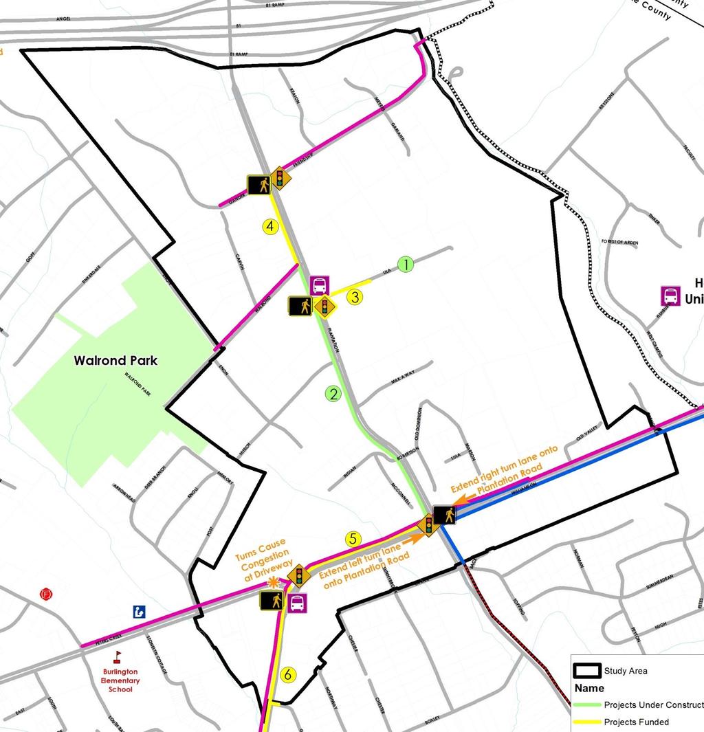
17 Plantation Road Project 2013: Concept when Consultants Started Red: Sidewalks Yellow: Shared Use Paths Yellow Dashed: Future Shared Use Paths Orange Dashed: Future Tinker Creek Greenway Dark Red: Bikeway Plan, Priority Alignments (Plantation Road) Orange: Bikeway Plan, Vision Alignments (Walrond Drive, Enon Drive) Future Traffic Signal at Lila Drive (conceptual/private entrance) 17
18 Plantation Road Project Evolution as Feedback Received during Fall Outreach and Analysis Roanoke County Parks, Recreation and Tourism will construct internal trails if the Shared Use Path would connect to Walrond Park Walrond Drive and Hitech Road intersections need work due to high tractor-trailer volumes Shared Use Path across Interstate 81 is costprohibitive and can be considered if/when FHWA/VDOT expands the bridge 18
19 Plantation Road Project Consultant Ideas Formalize an existing path to connect to proposed ped crosswalks at Gander/Friendship intersection Connect Hitech Rd. and Walrond Dr. shared use paths (SUP) using Enon Dr. to provide side street bicycle accommodations Avoid multiple industrial entrances by providing a SUP behind Enon Dr. businesses Provide side street bicycle facility with a McConnell Dr. SUP Connect the McConnell Dr. and Hitech Rd. SUPs with a Plantation Rd. connection Plan provides continuous bicycle and pedestrian accommodations from Williamson Road to Walrond Park and to the proposed Tinker Creek Greenway 19
20 Plantation Road Project Citizen Information Meeting Friendship Lane reconstruction and SUP needs to be a separate project Remove Enon Drive alternative VDOT Determination Lila Drive traffic signal, 400 road construction and expense of Exelis entrance relocation can be paid for with this project as part of Access Management improvements Bicycle Advisory Committee Meeting Recommendation to replace sidewalk with SUP to Lila Drive to allow bicycle commuters to safely access the three major businesses at a traffic signal with pedestrian crosswalks Additional Considerations Discussed SUP extension to Lila Drive and possibly beyond to Walrond Drive with BSC Ventures/Double Envelope Other Conclusions Center medians (landscaped or concrete) will not fit without blocking business entrances McConnell Dr. SUP more expensive than locating SUP along Plantation Road 20
21 Plantation Road Project 2014: Phase 1 Consultant Recommendation (West Side) Shared Use Path, curb and gutter from Williamson Rd. to Walrond Dr. (West Side) Sidewalk, curb and gutter from Walrond Dr. to Gander Way (East Side) Sidewalk, curb and gutter from Milk-A-Way Dr. to Friendship Ln. Signalized pedestrian crossing at Gander Way/Friendship Ln. Pedestrian lighting, landscaping, Welcome to Hollins sign, Broadband conduit Intersection improvements and entrance improvements (Option to add $200,000 for sidewalk to Walrond Park) 21
 Sidewalk, curb and gutter from Milk-A-Way Dr. to Friendship Ln. Signalized pedestrian crossing at Gander Way/Friendship Ln.")
22 Plantation Road Project What did we end up with? (West Side) Shared Use Path, curb and gutter from Williamson Rd. to Walrond Dr. (West Side) Sidewalk, curb and gutter from Walrond Dr. to Gander Way (East Side) Sidewalk, curb and gutter from Milk-A-Way Dr. to Friendship Ln. Signalized pedestrian crossing at Gander Way/Friendship Ln. Pedestrian lighting, landscaping, Welcome to Hollins sign, Broadband conduit Intersection improvements and entrance improvements (Option to add $200,000 for sidewalk to Walrond Park) Utility Relocations! 22


23 Plantation Road Project: Phase 1 Groundbreaking Erik Fox, Harris Vice President & General Manager Brian Sass, BSC Ventures President & CEO 23


24 Plantation Road Project: Phase 1 Status Williamson Road to Indian Road shared use path base (laying and compacting stone), curb, gutter, retaining wall against rebuilt open ditch, fence on top, extensive underground utility relocation (street trees) 24


25 Plantation Road Project: Phase 1 Status Indian Road to Hitech Road shared use path base, curb, gutter, rebuilt open ditch, gateway sign base (street trees) 25


26 Plantation Road Project: Phase 1 Status Hitech Road to Walrond Drive shared use path base, curb, gutter, overhead utility relocation, entrance reconstruction (street trees) 26
")
27 Plantation Road Project: Phase 1 Status Completion anticipated in June Ribbon cutting will take place shortly thereafter at Double Envelope/BSC Ventures Design Public Hearing Exhibit (2014) 27
28 Hollins Area Bicycle and Pedestrian Project Status 1. Plantation Road Bicycle, Pedestrian and Streetscape Improvement Project, Phase 1 Construction Underway; Completion June Lila Drive Turnaround (County CIP Funding) Construction Complete 3. Williamson Road/Peters Creek Road Bicycle and Pedestrian Safety Improvements (HSIP) Preliminary Engineering Underway; Construction Lila Drive/Route 115 Intersection Safety Improvements (SMART SCALE) Preliminary Engineering Underway; Construction FY
29 Hollins Area Bicycle and Pedestrian Project Status 5. Williamson Road Pedestrian Improvements (TAP) Preliminary Engineering FY 2018; Construction FY Plantation Road Bicycle, Pedestrian and Streetscape Improvement Project, Phase 2 (SMART SCALE) Preliminary Engineering FY 2022; Construction FY
30 Hollins Area Bicycle and Pedestrian Project Status Each project has a different funding source, timeline, and VDOT Project Manager

 Trail")
31 Related Transportation Projects: Greenways Tinker Creek Greenway - Hollins Trailhead Public Access Agreement between Hollins University and Roanoke County (2011) Trail opened (2012) 31
 County Board of Supervisors will consider adopting the Greenway Plan as a component of the")
32 Related Transportation Projects: Greenways Roanoke Valley Greenway Plan 2007 Plan: Tinker Creek Greenway identified as Priority Update underway with Tinker Creek Greenway identified as a Category 2 route (Greenfield in Botetourt County to Roanoke River Greenway in the City of Roanoke) County Board of Supervisors will consider adopting the Greenway Plan as a component of the Comprehensive Plan later this year 32


33 Gateway Corridor Improvements Roanoke County Gateway Signs Existing Gateway Proposed Gateway Plantation Road Welcome Sign Under Construction 33


34 Gateway Corridor Improvements VDOT Comprehensive Roadside Management Program Projects Joint projects between Friendship Retirement Community and the Williamson Road Area Business Association approved in 2012 Williamson Road and Plantation Road Williamson Road and Peters Creek Road 34
35 Hollins Area Plan Implementation Strategies Construct Hollins University segment of Tinker Creek Greenway, Phase II (I-81 to Carvins Cove) Ensure the maintenance of landscaping and other streetscape improvements throughout the study area Improve the pedestrian crosswalks at Plantation Road and Williamson Road Construct and install streetscape improvements throughout the study area (under construction) Improve the pedestrian crosswalks at Williamson Road and Peters Creek Road (in design) 5 of 17 strategies over ten years; 4 of these strategies involve VDOT 35
36 A Decade After the Adoption of the Hollins Area Plan 36


37 Hollins Center Planning Study 37
 Survey (February 1 to April 7): 393 completed Stakeholder")

38 Outreach Summary To-Date March Community Meeting Attendance: 100 (Saturday and Thursday) Survey (February 1 to April 7): 393 completed Stakeholder Interviews (including VDOT staff) Presentation to the Williamson Road Area Business Association Study Area Business Visits for March and May meetings 38
39 Major Themes Add sidewalks, crosswalks, bike lanes and/or shared-use paths to increase safety for all users in the study area Redevelop commercial areas into a mix of housing, locally-owned businesses and places to hang out Rebuild the library at a more central, connected location Protect, preserve and enhance natural resources and parks 39
40 Transportation Feedback Expand planned sidewalk and bicycle facilities Connect Walrond Park to the Tinker Creek Greenway and Carvins Cove Extend bus service to the area 40
41 41

42 Planning Study Next Steps May: Open House Community Meetings at the Hollins Library Thursday, May 10 from 4 p.m. to 7 p.m. Saturday, May 19 from 9 a.m. to 12 p.m. Summer: Draft Planning Studies Fall: Draft Plan Community Meetings Winter: Public Hearings 42

43 Conclusion 1. Comprehensive Planning, Land Use and Transportation are intertwined for better or for worse. 2. Roanoke County s VDOT Salem District and Salem Residency Staff are absolutely critical to our success in planning for future growth and development. 3. If you don t know your local VDOT staff, get to know them as they are an invaluable resource. Scoping a new SMART SCALE project with several VDOT and County Staff in 90+ degree heat at 4:35 p.m. last Friday afternoon 43

44 44 Questions
45 45 Megan G. Cronise, AICP Principal Planner (540)
Project Overview. Get Involved. Public Information Meeting. Contact Information
 Get Involved VDOT representatives will review and evaluate information received as a result of this meeting. Please fill out the comment sheet provided in this brochure if you have any comments or questions.
The Illinois Department of Transportation and Lake County Division of Transportation. Route 173, including the Millburn Bypass
 The Illinois Department of Transportation and Lake County Division of Transportation welcome you to this Public Hearing for U.S. Route 45 from Illinois Route 132 to Illinois Route 173, including the Millburn
3. Project Description and Attached Aerial Showing Proposed Improvement Location:
 RSTP Project Profile Candidate Project # 1. Project Sponsor(s): City of Roanoke, Roanoke County, and Botetourt County 2. Proposed Implementing Agencies: City of Roanoke, Roanoke County, and Botetourt County
Project Goal. RRRC Living Towns Planning Workshp. Town of Halifax Revitalization Project. Dynamic Planning & Management Duo: July 12, 2006
 Project Goal Town of Halifax Revitalization Project RRRC Living Towns Planning Workshp July 12, 2006 Town of Halifax Halifax County *** Revitalization Project Goal*** To create Economic Opportunity and
Executive Summary. NY 7 / NY 2 Corridor
 Executive Summary NY 7 / NY 2 Corridor Transportation and Land Use Study December 2005 Prepared for: Town of Colonie Capital District Transportation Committee Prepared by: Introduction: Land use decisions
The transportation system in a community is an
 7 TRANSPORTATION The transportation system in a community is an important factor contributing to the quality of life of the residents. Without a sound transportation system to bring both goods and patrons
SH 199 Corridor Master Plan. Community Meeting No. 2 May 31, 2017
 Community Meeting No. 2 May 31, 2017 Transportation Projects On or Near SH 199 SH 199 from 0.3 miles south of FM 1886 to south end of Lake Worth bridge Construct freeway mainlanes and frontage roads 10-Year
NORTH CLAYMONT AREA MASTER PLAN COMMUNITY WORKSHOP #1 FEBRUARY 3, 2016
 NORTH CLAYMONT AREA MASTER PLAN COMMUNITY WORKSHOP #1 FEBRUARY 3, 2016 1. Introduction To the team and to the Plan Planning Partners The Claymont Community WILMAPCO New Castle County Claymont Renaissance
Urban Development Area (UDA) Process in Virginia: History & Requirements
 Process in Virginia: History & Requirements") Urban Development Area (UDA) Process in Virginia: History & Requirements J. Kelli Nash Office of Intermodal Planning and Investment VDOT Coordinating Transportation & Land Use Forum Thursday, June 2, 2016
Urban Development Area (UDA) Process in Virginia: History & Requirements J. Kelli Nash Office of Intermodal Planning and Investment VDOT Coordinating Transportation & Land Use Forum Thursday, June 2, 2016
1.0 INTRODUCTION 1.1 TH 14 WEST STUDY AREA Project Description Functional Classification Purpose of the Project
 1.0 INTRODUCTION 1.1 TH 14 WEST STUDY AREA 1.1.1 Project Description The Trunk Highway (TH) 14 West Corridor is a two-lane roadway approximately 22 miles in length. Located in Nicollet County, the corridor
CITY OF CHARLOTTESVILLE, VIRGINIA CITY COUNCIL AGENDA
 CITY OF CHARLOTTESVILLE, VIRGINIA CITY COUNCIL AGENDA Agenda Date: December 16, 2013 Action Required: Adoption of Resolution Presenter: Staff Contacts: Title: James E. Tolbert, AICP, Director of NDS James
Scope of Services. River Oaks Boulevard (SH 183) Corridor Master Plan
 Corridor Master Plan") Scope of Services River Oaks Boulevard (SH 183) Corridor Master Plan PROJECT AREA The project area consists of the River Oaks Boulevard (SH 183) corridor bounded by SH 199 at the northern end and the Trinity
Scope of Services River Oaks Boulevard (SH 183) Corridor Master Plan PROJECT AREA The project area consists of the River Oaks Boulevard (SH 183) corridor bounded by SH 199 at the northern end and the Trinity
Finish Roanoke River Greenway from Green Hill Park to the Blue Ridge Parkway Regional Surface Transportation Program Application
 Finish Roanoke River Greenway from Green Hill Park to the Blue Ridge Parkway Regional Surface Transportation Program Application 1. Project Sponsors: City of Roanoke, City of Salem, Roanoke County, Town
FDOT D4 Complete Streets
 FDOT D4 Complete Streets Context Sensitive Solutions Directs that complete street solutions will complement the context of the community. Collaborative approach to decision making, project development,
I. DESCRIPTION OF PROPOSED ACTION... 1 A. General Description... 1 B. Historical Resume and Project Status... 2 C. Cost Estimates...
 PROJECT COMMITMENTS SUMMARY... S-1 1. Type of Action... S-1 2. Description of Action... S-1 3. Summary of Purpose and Need... S-1 4. Alternatives Considered... S-2 5. NCDOT Alternatives Carried Forward...
Small Area Plan. South Gateway
 Small Area Plan Adopted May 12, 2008 South Gateway Purpose. The South Gateway Small Area Plan defines the City s expectations for the future of the southern entrance to the City at Interstate 85 and Highway
SECTION 4(f) DE MINIMIS DOCUMENTATION
 DE MINIMIS DOCUMENTATION") SECTION 4(f) DE MINIMIS DOCUMENTATION Illinois Route 60/83 IL 176 to the intersection of IL 60 (Townline Road) Lake County P-91-084-07 Mundelein Park and Recreation District Project Limit SECTION 4(f)
SECTION 4(f) DE MINIMIS DOCUMENTATION Illinois Route 60/83 IL 176 to the intersection of IL 60 (Townline Road) Lake County P-91-084-07 Mundelein Park and Recreation District Project Limit SECTION 4(f)
CHAPTER 7: Transportation, Mobility and Circulation
 AGLE AREA COMMUNITY Plan CHAPTER 7 CHAPTER 7: Transportation, Mobility and Circulation Transportation, Mobility and Circulation The purpose of the Transportation, Mobility and Circulation Chapter is to
Stafford County Strategic Plans
 Stafford County Strategic s Strategic Department Description Date Adopted Board of Supervisors Priorities Fiscal Responsibility Education Public Safety Infrastructure Economic Development Service Excellence
Route 1 Corridor Study
 Route 1 Corridor Study Westbrook, Connecticut A Vision for the Connecticut Shoreline Public Informational Meeting July 28, 2015 Lower Connecticut River Valley Council of Governments Fitzgerald & Halliday,
Places29: List of Implementation Projects
 Important Points to Keep in Mind When Using This List Places29: List of s Each of the projects in this List represents an action needed to implement the Places29 Master Plan. The projects are grouped first
FOUR MILE RUN VALLEY WORKING GROUP AND CHARGE
 FOUR MILE RUN VALLEY WORKING GROUP AND CHARGE Adopted April 16, 2016 Amended July 19, 2016 Overview of Integrated Effort The overall goal of the Four Mile Run Valley (4MRV) initiative is to develop a comprehensive
CHAPTER 1 Introduction
 CHAPTER 1 Introduction From sea to summit, Lane County covers almost 4,800 square miles of diverse Oregon landscape. Stretching from the Pacific Ocean through the Coastal Range, the Willamette Valley to
Public input has been an important part of the plan development process.
 Lakewood s Comprehensive Plan recognizes that transportation helps shape the community, and that the way the community provides for the safe and efficient movement of people affects the character of the
Urban Development Areas Bedford County
 5 Urban Development Areas Bedford County UDA Needs Profile: All UDAs Bedford County has designated two UDAs: areas just outside the Bedford City Limits (generally to the south and east of the city) and
CITY OF BOYNTON BEACH SE 1 ST STREET COMPLETE STREETS IMPROVEMENTS
 CITY OF BOYNTON BEACH SE 1 ST STREET COMPLETE STREETS IMPROVEMENTS N Project Location -Town Square -Villages at Ocean SE 1st St, between E Woolbright Rd and SE 2nd Ave Project Location -Boynton One -Publix
RESOLUTION NO. R Refining the route, profile and stations for the Downtown Redmond Link Extension
 RESOLUTION NO. R2018-32 Refining the route, profile and stations for the Downtown Redmond Link Extension MEETING: DATE: TYPE OF ACTION: STAFF CONTACT: Capital Committee Board PROPOSED ACTION 09/13/2018
A. INTRODUCTION B. PROJECT LOCATION
 Chapter 1: Project Description A. INTRODUCTION The Lower Manhattan Development Corporation (LMDC), a subsidiary of the New York State Urban Development Corporation, doing business as the Empire State Development
Area Plans. September 18, 2012
 Area Plans September 18, 2012 Transfer ratio for existing development up to 1:6 depending on sending parcel sensitivity and distance from community centers and/or transit routes. Within Town Center and
Local Growth Planning in North Central Green Line Communities
 2018 April 30 Page 1 of 6 EXECUTIVE SUMMARY This report outlines a high-level scope for local growth planning for north central Green Line communities. The catalyst for this review is the significant investments
PLANNING COORDINATING COMMITTEE
 PLANNING COORDINATING COMMITTEE Fall Meeting/Luncheon Welcome! October 16, 2009 PLANNING COORDINATING COMMITTEE Fall Meeting/Luncheon WELCOME! WELCOME! October 16, 2009 October 16, 2009 Agenda I. Lunch/Socialize
Project Overview. Fairfax County Parkway Widening Fairfax County. Get Involved. Public Information Meeting. Contact Information
 Get Involved VDOT representatives will review and evaluate information received as a result of this meeting. Please fill out the comment sheet provided in this brochure if you have any comments or questions.
New York Avenue Streetscape and Trail Project Public Meeting #1 Summary
 New York Avenue Streetscape and Trail Project Public Meeting #1 Summary I. King Jordan Student Academic Center (SAC) Gallaudet University, Washington, DC February 23, 2017 Table of Contents 1.0 Introduction...
Welcome. Walk Around. Talk to Us. Write Down Your Comments
 Welcome This is an information meeting introducing the applications for proposed redevelopment of the Yorkdale Shopping Centre site at 3401 Dufferin Street and 1 Yorkdale Road over the next 20+ years,
West Dennis Center: Bass River to Old Main Street. West Dennis Business District: Old Main Street to Dennis Commons
 West Dennis Center: Bass River to Old Main Street West Dennis Business District: Old Main Street to Dennis Commons Dennisport Center: Dennis Commons to Division Street Main Street Project Goals Project
Public Forum. Kelley s Corner: The Corner that Connects Us. The Cecil Group. March 7, Acton 2020 Town of Acton.
 Public Forum Acton 2020 Town of Acton March 7, 2013 AGENDA Purpose of Forum Kelley s Corner Project Examples of the Planning Processes Next Steps Dialogue: Questions and Answers PURPOSE Acton 2020 April
1INTRODUCTION. Purpose of the Truckee Railyard Master Plan
 1INTRODUCTION Purpose of the Truckee Railyard Master Plan The purpose of the Truckee Railyard Master Plan is to capture and describe the Town s vision for the Railyard Area and to guide its future redevelopment.
Corridor Enhancements
 Corridor Enhancements Safety is MoDOT s first priority in widening and rebuilding I-70 across the state of Missouri. MoDOT also understands that the interstate - and its interchanges and overpasses - are
Issues Requiring Future Study
 Issues Requiring Future Study Transportation planning is an ongoing process that tends to identify new issues as it finds solutions for others. Some issues are so complex that a solution to one problem
Chain Bridge Road Sidewalk Improvements Citizen Council Work Session
 Chain Bridge Road Sidewalk Improvements Citizen Council Work Session May 10, 2016 Project Location 2 Project Objectives Provide a continuous pedestrian facility (sidewalk) connection from Downtown City
Rutherford County Projects
 Rutherford Projects 5307 Urban Operating for Rover Public Transit - Relax & Ride Service TIP # 2005-006 Transit Operations Murfreesboro Public Transit Rutherford Length 0.00 Regional Plan ID Consistent
1.0 Purpose of a Secondary Plan for the Masonville Transit Village
 Report to Planning and Environment Committee To: Chair and Members Planning & Environment Committee From: John M. Fleming Managing Director, Planning and City Planner Subject: Masonville Transit Village
Gratigny Parkway East Extension Project Development & Environment (PD&E) Study
 Study") Gratigny Parkway East Extension Project Development & Environment (PD&E) Study Session 4: Presentation of Charrette Results December 8, 2010 MDX Work Program #: 92407 ETDM#: 11500 Project Location & Description
Gratigny Parkway East Extension Project Development & Environment (PD&E) Study Session 4: Presentation of Charrette Results December 8, 2010 MDX Work Program #: 92407 ETDM#: 11500 Project Location & Description
FOUR MILE RUN VALLEY WORKING GROUP AND CHARGE Adopted April 16, 2016 Amended July 19, 2016
 FOUR MILE RUN VALLEY WORKING GROUP AND CHARGE Adopted April 16, 2016 Amended July 19, 2016 Working Group Charge The Working Group is charged by the County Board to collaborate with staff to provide commission,
SUBJECT: Waterfront Hotel Planning Study Update TO: Planning and Development Committee FROM: Department of City Building. Recommendation: Purpose:
 Page 1 of Report PB-23-18 SUBJECT: Waterfront Hotel Planning Study Update TO: Planning and Development Committee FROM: Department of City Building Report Number: PB-23-18 Wards Affected: 2 File Numbers:
12/9/2013. HOLLYWOOD/PINES CORRIDOR PROJECT AMPO 2013 Annual Conference October 24, Our Perspective. Broward.
 HOLLYWOOD/PINES CORRIDOR PROJECT AMPO 2013 Annual Conference October 24, 2013 Our Perspective Broward Fort Lauderdale 1 Broward Metropolitan Planning Organization Fort Lauderdale Fort Lauderdale Skyline
3. VISION AND GOALS. Vision Statement. Goals, Objectives and Policies
 Vision Statement Queen Creek s interconnected network of parks, trails, open spaces and recreation opportunities provide safe and diverse activities and programs that sustain its unique, small town, equestrian
Plan Overview. Manhattan Area 2035 Reflections and Progress. Chapter 1: Introduction. Background
 Plan Overview The Manhattan Urban Area Comprehensive Plan (the Comprehensive Plan) is a joint planning initiative of the City of Manhattan, Pottawatomie County, and Riley County. The 2014 Comprehensive
Secrest Short Cut and Monroe Expressway Small Area Plan AUGUST 29, 2018
 Secrest Short Cut and Monroe Expressway Small Area Plan AUGUST 29, 2018 Background and Process Monroe Expressway will be open by the end of 2018 Union County and Indian Trail identified a need to revisit
July 12, Columbus City Council City Hall 90 West Broad Street Columbus, OH RE: I-70/71 Columbus Crossroads Project
 OHIO DEPARTMENT OF TRANSPORTATION DISTRICT 6 400 EAST WILLIAM STREET DELAWARE, OHIO 43015 800.372.7714 Columbus City Council City Hall 90 West Broad Street Columbus, OH 43215-9015 RE: I-70/71 Columbus
Asbury Chapel Subdivision Sketch Plan
 Asbury Chapel Subdivision Sketch Plan PART 1: PROJECT SUMMARY Applicant: NVR Inc. Project Size: +/- 76.13 acres Parcel Numbers: 02101112,02116101,02116112, 02116113 Current Zoning: Transitional Residential
Building Great Neighbourhoods. Strathcona
 Building Great Neighbourhoods Strathcona March 21, 2018 Becky Redford Project Manager, Planning & Design Building Great Neighbourhoods Integrated Infrastructure Services Welcome and Purpose To provide
Fifth and Detroit Street Design May 2017 Capital Improvements Committee. DOWNTOWN Street Design
 1 Fifth and Detroit Street Design May 2017 Capital Improvements Committee Agenda 2 Review Street Configuration Prior Meeting Review Outreach Synopsis Functional Street Design Refinements Curb Edge, Turning
Capital Projects in and near Odenton Town Center
 Capital Projects in and near Odenton Town Center Map ID Anne Arundel County Department of Public Works This project provides for the design, right of way acquisition, and construction of approximately
Rich Valley Greenway Master Plan. Central Greenway Connectivity Study
 Rich Valley Greenway Master Plan Central Greenway Connectivity Study Dakota County Planning Commission February, 2017 Rich Valley Greenway Master Plan Dakota County Greenway Vision Establish a County-wide
Tyvola & Archdale Transit Station Area Plan. May 15, 2008
 Tyvola & Archdale Transit Station Area Plan First Public Meeting May 15, 2008 Presentation Outline 1. Purpose and Process 2. Station Area Overview 3. Plan Recommendations Vision Land Use Transportation
Transportation Land Use Integration & Regional Planning. Don Kostelec, AICP Senior Planner, Louis Berger Group February 1, 2010
 Transportation Land Use Integration & Regional Planning Don Kostelec, AICP Senior Planner, Louis Berger Group February 1, 2010 Transportation Land Use Integration DOT-HUD-EPA Sustainable Communities Initiative
Pennsy Greenway Trail
 Town of Schererville Pennsy Greenway Trail DES. #s: 0401062, 1173595 & 1382661 Construction of Pennsy Greenway Trail beginning at Wilhelm Street and continuing northwest along the former Penn Central railroad
Request for Proposal
 Request for Proposal 10 th Street Corridor Master Plan Department of Planning and Zoning 500 Quartermaster Court Suite 200 Jeffersonville, IN 47130 April 18, 2017 For further information contact: Chad
master plan of highways bus rapid transit amendment
 Scope of Work master plan of highways bus rapid transit amendment September 2011 Montgomery County Planning Department M-NCPPC MontgomeryPlanning.org 1 Scope of Work master plan of highways bus rapid transit
WELCOME! 8 8:30 6: TH STREET IMPROVEMENTS. Open House. Presentation & Q&A
 WELCOME! 168 TH STREET IMPROVEMENTS 6:30 Open House 7 8 Presentation & Q&A 8 8:30 Open House WELCOME Todd Pfitzer City of Omaha Engineer Bob Stubbe City of Omaha Public Works Director Jon Meyer Project
PSRC REVIEW REPORT & CERTIFICATION RECOMMENDATION
 PSRC REVIEW REPORT & CERTIFICATION RECOMMENDATION KITSAP COUNTY COUNTYWIDE PLANNING POLICIES July 2, 2012 BACKGROUND A major emphasis of the Washington State Growth Management Act (GMA) is the need to
Implementation Guide Comprehensive Plan City of Allen
 Implementation Guide 2030 Comprehensive Plan City of Allen DRAFT 2015 Implementation Guide Allen 2030 Comprehensive Plan INTRODUCTION The Comprehensive Plan serves as a guide for the growth and development
10 Implementation. Implementation. Responsibility for Implementation. Blueprint for Bloomsburg. Town of Bloomsburg Comprehensive Plan 10-1
 Implementation 10 Implementation This chapter overviews how to use the comprehensive plan as a land use and programming tool for the Town of Bloomsburg and recommends annual review of the plan by the Town
Appendix 2. Implementation Project Descriptions Page A2-1
 Appendix 2. Implementation Descriptions This appendix provides a more detailed description of each of the Places29 Implementation s than is given in the List of Implementation s at the end of Chapter 8.
Don Mills Crossing Study and Celestica Lands Development Application Community Meeting, Open House, and Breakout Discussions
 Consultation Summary Don Mills Crossing Study and Celestica Lands Development Application Community Meeting, Open House, and Breakout Discussions This report is not intended to provide a verbatim transcript
2017 General Obligation Bond
 2017 General Obligation Bond Presentation of Public and Council Projects to the Transportation & Mobility Stakeholder Committee April 13, 2017 Agenda Deferred Maintenance Project Development Process Projects
I-70 Corridor Enhancement Plan
 i - Table of Contents Table of Contents Chapter I Overview Chapter II Bridge and Roadway Improvements Chapter III Landscape Enhancements Chapter IV Riparian Corridors Chapter V Showcase Missouri Plan Chapter
East Bench Master Plan Update
 Community & Economic Development Office of the Director East Bench Master Plan Update To: From: Planning Commission Wayne Mills, Senior Planner Date: November 18, 2015 CC: Re: Nora Shepard, City Planning
The Lower SaLuda Greenway
 The Lower SaLuda Greenway InITIaTIve a FLourIShInG Greenway. a hub For economic GrowTh. a ConneCTIon BeTween CoMMunITIeS. In April 2017 the Michael J. Mungo Foundation and Lexington County commissioned
Introduction. Chapter 1. Purpose of the Comprehensive Plan Plan Organization Planning Process & Community Input 1-1
 Chapter 1 Introduction Lakewood 2025: Moving Forward Together Purpose of the Comprehensive Plan Plan Organization Planning Process & Community Input 1-1 Purpose of the Comprehensive Plan The Comprehensive
Chesterfield County Project Update
 Chesterfield County Project Update SOUTHEAST HIGH SPEED RAIL TIER II ENVIRONMENTAL IMPACT STATEMENT RICHMOND, VA, TO RALEIGH, NC CHESTERFIELD COUNTY, VA OFFICIALS BRIEFING February 2013 Federal Railroad
PROJECT BACKGROUND. Preliminary Design Scope and Tasks
 PROJECT BACKGROUND Preliminary Design Scope and Tasks The purpose of this Study is the development of preliminary designs for intersection improvements for Trunk Highway (TH) 36 at the intersections of
Blueprint Denver Task Force Meeting #
 Blueprint Denver Task Force Meeting #1 6.23.16 1. Welcome and Introductions Your name and affiliation Name 1 thing you love about Denver Name 1 thing you d change about Denver All in 30 seconds! Ready,
DAVIDSON MOBILITY PLAN REQUEST FOR PROPOSALS. Town of Davidson, NC June 12th, 2017
 I. GENERAL BACKGROUND DAVIDSON MOBILITY PLAN REQUEST FOR PROPOSALS Town of Davidson, NC June 12th, 2017 The Town of Davidson is a community of approximately 13,000 residents and home to Davidson College
TAC/CAC, TPO Project Update February 2016
 A1A MULTIMODAL CORRIDOR PLANNING AND ENGINEERING ANALYSIS Florida Department of Transportation TAC/CAC, TPO Update February 2016 PRESENTATION FOOTERT Meeting Agenda What We Plan To Discuss Background New
WELCOME 50 street cp rail grade separation + road widening. public information session #1 June 26, pm to 8 pm
 WELCOME 50 street cp rail grade separation + road widening public information session #1 June 26, 2018 5 pm to 8 pm session purpose To provide residents, businesses, and users of 50 Street with the opportunity
Atlanta BeltLine Corridor Environmental Study. Scoping Meeting August 2008
 Atlanta BeltLine Corridor Environmental Study Scoping Meeting August 2008 What Will We Be Discussing Today? Study Overview - How Did We Get Here? - What Is the Study About? - Who Is Involved? - Where Is
PROJECT SHOWING MINUTES
 PROJECT SHOWING MINUTES North Lynn Street Esplanade Improvements Project No. 0029-000-859, C501, B605 UPC No. 109813 November 1, 2017 10:00 a.m. 1911 North Ft. Myer Drive, LL-10, Arlington, VA Overview
Date: April 10, 2017 City Council Work Session April 24, 2017: Status Report on the Comprehensive Plan Update and Transportation Master Plan
 AGENDA REPORT To: From: By: Honorable Mayor and City Council Members Warren Hutmacher, City Manager Sharon Ebert, Director Community Development Date: April 10, 2017 Agenda: City Council Work Session April
Welcome to the. Open House
 Welcome to the 5th Street to Kinsman Road Open House November 14 5:30 7:00 p.m. Please sign in Project Overview In December 2016, City Council adopted SW 5th Street as the preferred alignment to connect
TIRZ 17/Redevelopment Authority Capital Improvements Plan Projects
 Gessner Widening: T-1701 What: Widen the road from a six-lane divided boulevard to an eight-lane divided boulevard street section, increase turn lanes, update traffic signal system, improve drainage by
Public may provide comments on the GDP within the next two weeks (December 24)
") 25/70 General Development Plan (GDP) Public Meeting Wednesday, December 10, 2014 6:00 8:00 P.M. District 1 Police Station Community Room 1311 W 46th Ave, Denver, CO 80211 Council Woman Montero: This particular
25/70 General Development Plan (GDP) Public Meeting Wednesday, December 10, 2014 6:00 8:00 P.M. District 1 Police Station Community Room 1311 W 46th Ave, Denver, CO 80211 Council Woman Montero: This particular
Public Hearing. Charlotte County-Punta Gorda MPO - Meeting Rooms A and B March 14, open house at 4 p.m., formal presentation at 5 p.m.
 Public Hearing Charlotte County-Punta Gorda MPO - Meeting Rooms A and B March 14, 2019 open house at 4 p.m., formal presentation at 5 p.m. Welcome to the Public Hearing for the Harborview Road (CR 776)
Alternatives Development Three conceptual alternatives were developed for the Race Road/Jessup Village Planning Study and are described below:
 Race Road/Jessup Village Planning Study (H550601) Project Newsletter Spring 2015 Project Description The Study Team, consisting of staff from Anne Arundel County (Department of Public Works and Department
THREE-YEAR CAPITAL IMPROVEMENT PLAN FY
 THREE-YEAR CAPITAL IMPROVEMENT PLAN FY2016 2018 Annual CIP Development Process Public Works & Engineering Divisions Prepare List of Capital Needs and Recommended Deferred Maintenance Public Works & Engineering
BEST PRACTICES FOR PROJECT NOMINATIONS TA Set-Aside Program
 BEST PRACTICES FOR PROJECT NOMINATIONS 2017 TA Set-Aside Program Focus of this presentation Photos Public Support Maps & Exhibits Proposed Budget Design Details Project Evaluation & Selection Criteria
Infrastructure Engineering Planning Construction Suite 300 Minneapolis, MN Tel: Fax:
 Infrastructure Engineering Planning Construction 701 Xenia Avenue outh uite 300 Minneapolis, MN 55416 Tel: 763-541-4800 Fax: 763-541-1700 Memorandum To: Minnehaha Creek Watershed District Board From: Tony
Making Transit Oriented Development Work For Boonton, NJ
 Making Transit Oriented Development Work For Boonton, NJ Bloustein School of Planning and Public Policy Studio Dan Burton Loannie Dao Webster Slater Brandon Williams Ian Watson Maria Laham Nicola Mammes
Section 4 BUILDING THE MASTER PLAN
 The Master Plan 33 Section 4 BUILDING THE MASTER PLAN Figure 4:1. A collaborative effort characterized the two design workshops sponsored by DISC to create hypothetical Master Plans for the Towers Property
2010 Plan of Conservation and Development
 2010 Plan of Conservation and Development Wilton Planning and Zoning Commission Adopted November 2, 2009 Effective January 1, 2010 WILTON 2010 PLAN OF CONSERVATION & DEVELOPMENT PARTICIPANTS Planning &
People who are members of historically disenfranchised racial, ethnic, cultural, and other identity groups are encouraged to apply.
 CALL TO ARTISTS REQUEST FOR QUALIFICATIONS CITY OF TACOMA MUNICIPAL ART PROGRAM East 64 th Streetscape, Tacoma, WA APPLICATION DEADLINE October 10, 2018, 11:59pm BUDGET $72,000, all-inclusive SUMMARY The
Complete Streets in Lancaster County
 Complete Streets in Lancaster County PRESENTED BY: Robert Bini, AICP Director for Transportation Planning November 14, 2017 Lancaster County is a growing county of over 534,000 and the bottom line is...
AGENDA ACTION ITEMS INFORMATION ITEMS
 NOACA Bicycle and Pedestrian Advisory Council Meeting Friday, March 21 st, 2014 10:30 a.m. NOACA Office 1299 Superior Avenue Cleveland, Ohio 44114 Phone: (216) 241-2414; website: www.noaca.org AGENDA ACTION
TENNESSEE STATE ROUTE 109 CORRIDOR MANAGEMENT AGREEMENT MEMORANDUM OF UNDERSTANDING CORRIDOR MANAGEMENT ALONG STATE ROUTE 109
 TENNESSEE STATE ROUTE 109 CORRIDOR MANAGEMENT AGREEMENT MEMORANDUM OF UNDERSTANDING CORRIDOR MANAGEMENT ALONG STATE ROUTE 109 I. Purpose The purpose of this Agreement is to provide a framework for the
Onondaga County Sustainable Streets Project. Onondaga County Planning Federation June 7, Onondaga County Sustainable Streets Project 1
 Onondaga County Sustainable Streets Project Onondaga County Planning Federation June 7, 2012 Onondaga County Sustainable Streets Project 1 Sustainable Streets 1. Introduction to the SMTC 2. Sustainable
2010 Tentative Enhancement Program Allocations (FY11)
") Bristol 10011 Buchanan County Buchanan County project cost $1,190,332 Bull Creek Trail - construction of a pedestrian/bicycle trail along abandoned request amount $240,323 railroad right of way. allocation
Bristol 10011 Buchanan County Buchanan County project cost $1,190,332 Bull Creek Trail - construction of a pedestrian/bicycle trail along abandoned request amount $240,323 railroad right of way. allocation
11.0 TRANSPORTATION ELEMENT
 11.0 TRANSPORTATION ELEMENT Transit, Circulation and Parking Sub-Element: For all campuses, FIU's goal is to increase multimodal access. In combination with other measures - such as the development of
MONTGOMERY COUNTY METRO STATION AREA DESIGN CHARRETTE
 MONTGOMERY COUNTY METRO STATION AREA DESIGN CHARRETTE Shady Grove Metro Station Area Charrette Closing Presentation October 25-28, 2000 MONTGOMERY COUNTY, MD M-NCPPC Design Collective, Inc. Architects
RUTHERFORD NASHVILLE AREA MPO FY TIP - ADOPTED DECEMBER
 RUTHERFORD NASHVILLE AREA MPO FY -2017 TIP - ADOPTED DECEMBER 11, 2013 5307 Urban Operating for Rover Public Transit - Relax & Ride Service TIP # 2005-006 Transit Operations Murfreesboro Public Transit