Haslemere Design Statement
|
|
|
- Percival Cameron
- 5 years ago
- Views:
Transcription


1 For Beacon Hill, Critchmere, Grayswood, Haslemere, Hindhead and Shottermill Ensuring new development takes account of local character

2 Contents Overview 3 1. Introduction 4 2. What makes Haslemere Special and Distinctive 9 3. Geography of the area 12 4 Landscape and Natural Environment Transport and Access Design and Architectural Guidance Designs for your neighbourhood Haslemere Town Conservation Area Haslemere South of Town Centre Haslemere North of Town Centre Grayswood Shottermill and Critchmere Special Green Areas Industrial Areas Hindhead and Beacon Hill 45 Appendices 1. National Sustainability Design Guidelines WBC Shopfront Policy Abbreviations Acknowledgements 52 Haslemere War Memorial 5. Glossary of terms Bibliography Index of road names in the Haslemere area Complete set of Design Guidelines 58 2


3 Overview The overall aim of the Haslemere Design Statement (HDS) is to produce a set of Design Guidelines to be adopted by Waverley Borough Council (WBC) as a material consideration when planning applications are considered for the Haslemere area. The Introduction to the HDS outlines its context, subject matter, intended audience and community involvement. This is followed by a resumé of what makes the Haslemere area distinctive and a snapshot of Haslemere today. The next section, 3, provides a description of the geography of the area, whilst Section 4 continues with a general description of the area s landscape and natural environment, plus related Design Guidelines. Section 5 provides the context for Transport and Access in the area and associated Guidelines. Section 6 sets out the generic Design Guidelines for all building developments, which should be applied to the whole of the Haslemere area and particularly emphasises those which relate to the local vernacular. The section concludes with some notes about sustainability and related Design Guidelines. Haslemere Town Hall Section 7 has divided Haslemere into eight discrete areas (the headings are coloured to match the areas on the map on page 26). After providing a brief history, the characteristics of each area are listed. Where appropriate, additional specific and relevant guidelines for each area are set out. However, it is essential that these are always used in conjunction with the generic design guidelines set out in context in sections 4, 5 and 6. The complete set of guidelines are brought together in Appendix 8. The HDS concludes with a number of Appendices which give added details relating to the preparation and drawing up of the document. It should be noted that when the HDS was presented to WBC for adoption, it was accompanied by a second document which set out an audit of the informal and statutory consultations which had taken place. Finally, it is hoped that the HDS will be adhered to as a point of reference by all those who have an interest in undertaking any development in the area. Haslemere High Street 3 Overview

4 1. Introduction N The administrative boundaries of Haslemere Town Council as covered by this document Crown copyright and database right 2011 Ordnance Survey LA Section 1: Introduction


5 Background In 2000 the former Countryside Agency (now Natural England) launched the Market Town Initiative. This was in response to growing public concern about the widespread deterioration of such towns due to altered lifestyles, new patterns of mass retailing and other social changes. It proposed that each town should carry out a health check with the involvement of the community. This would identify strengths and weaknesses, threats and opportunities which would enable the town to achieve an overall vision for its improvement. The Haslemere Initiative organised the town s first health check in 2003 and in the following five years it achieved many of its targets. It was subsequently decided that a second health check to review where we are at should be carried out in The main outcome of this was that a Design Statement should be drawn up for Haslemere Town (including Shottermill and Critchmere) and the surrounding villages (Grayswood, Hindhead and Beacon Hill). The first meeting of the Haslemere Design Statement (HDS) team took place in mid-may The Project has been initiated and funded jointly by the Haslemere Town Council (HTC) and the Haslemere Initiative. The overall aims of the Design Statement are to: develop guidelines which have a positive influence on development throughout Haslemere and the surrounding area, and ensure a sustainable and attractive environment for future generations. What does the Haslemere Design Statement do? Identifies the key design elements that should be taken forward to influence all new developments including affordable housing Helps developers to achieve quality designs which are appropriate to the location in which they are proposed Reflects the separate characters of the different neighbourhoods as they relate to design matters Shows how this local character can be protected and enhanced in new developments Creates partnerships between different groups in the community, acting as a catalyst for new initiatives and speeding up the development process By being adopted by Waverley Borough Council (WBC) to supplement statutory planning policies, it becomes a material consideration in future planning decisions. Haslemere High Street, looking north Haslemere from Swan Barn Community Orchard, just a short distance from the High Street, showing how wooded it is close to the town centre 5 Section 1: Introduction


6 What does the Haslemere Design Statement look at? Character Diversity Local distinctiveness Harmony of individual buildings, of groups of buildings, and their setting in the wider landscape Design and materials used in buildings Spaces between buildings Housing Density General sense of place throughout Haslemere and the surrounding villages. Haslemere Design Statement Who is the Haslemere Design Statement meant for? People considering development which could change the appearance of some part of the Haslemere area, no matter what the size i.e. developers, property owners, householders and businesses Architects, urban designers, landscape architects and other professionals acting on behalf of clients commissioning such work Staff and Councillors of the local planning committee responsible for development decisions and investment in the public realm Those consulted on proposed developments e.g. Haslemere Town Council, Highway Authorities, The Haslemere Society, local community groups, residents and businesses. Verandah Cottage The document seeks to ensure that when new development takes place it takes account of the local character of the area. Shepherds Hill 6 Section 1: Introduction

 by describing the local character of the town and setting out a number of design guidelines")


7 Status and Planning Context This Haslemere Design Statement (HDS) has been adopted by WBC as non-statutory planning guidance. This means that the design guidelines stated here are a material consideration when proposals for new development in the Haslemere area are being considered by the planning authorities. The HDS also accords with the National Planning Policy Framework (NPPF - March 2012) by describing the local character of the town and setting out a number of design guidelines which will support good design for Haslemere. This HDS stands alone, however reference should be made to the other official documents, such as: WBC Haslemere Local Plan Supplementary Planning Guidance, 1995 Saved policies of the WBC Local Plan 2002 WBC Local Development Framework Consultation Draft Document 2011 The latest National Policy. The HDS supports and expands local planning policies and proposals for the Haslemere area. In particular it adds detail to, and complements, Policies D4 Design & Layout, D14 Planning Benefits, C3 Surrey Hills Area of Outstanding Natural Beauty (AONB) & Area of Great Landscape Value (AGLV), BE4 Haslemere Hillsides, and BE6 Low Density Residential Areas in the saved policies of the WBC Local Plan Any policy document demands regular review and it is recommended that the statement be the subject of a thorough review at least every five years. Haslemere Design Statement 7 Section 1: Introduction
. Extensive public awareness, consultation and participation have been a priority throughout.")


8 Community Involvement The HDS has been written and produced by a Steering Group of committed and enthusiastic people for the benefit of the community who have been consulted and invited to express their views (reference the separate, supporting Consultation Document). Extensive public awareness, consultation and participation have been a priority throughout. This has involved a wide variety of different approaches including: Drawing on valuable research carried out for the Haslemere Health Check 2002/3 and the follow-up document in 2008 Continued information sharing with WBC, HTC, Haslemere Society, Transition Town Haslemere, Haslemere Initiative and the Haslemere Chamber of Trade and Commerce Proactive involvement and promotion of HDS through the Town Council s publication Haslemere Happenings Informal consultations: three public, interactive work shops, Autumn 2010 culminating in over 4,400 comments Media information and coverage, posters, flyers, articles in the Haslemere Herald and The Messenger Formal public consultation on the draft HDS which took place between 16th January and 29th February This included three open exhibitions, website and media coverage National and local organisations were sent individual letters explaining the HDS and giving them the internet link to enable them to comment and to cascade the consultation to their members. Full details of the many ways in which the community was involved in the drafting of this guidance can be found in the supporting Consultation Statement, which stands alongside the HDS. Full regard was given to the requirements of the current WBC Statement of Community Involvement (SCI) Haslemere Fringe Festival and Classic Car Show 2010, Lion Green 8 Section 1: Introduction


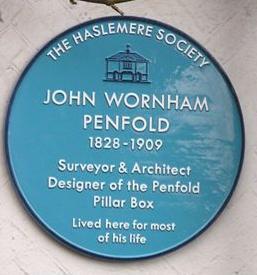
9 2. What Makes Haslemere Special and Distinctive? Haslemere s High Street provides the most enduring image of the town, for the casual visitor and resident alike: the sweep of the road as it falls to the centre of the old town, the quaint and perfectly proportioned modest town hall in the mid distance, the grandeur of the ancient horse chestnut in front of the town s Georgian House Hotel. It is a quintessentially English scene and, when bathed in warm sunlight, is surely one of the most lovely and distinctive places in Surrey. and woodland paths which lead on to Grayswood and a host of small hamlets. The character of the town is firmly established by its individual small family-run shops, intermingled with branches of some large national chains. This is a friendly town with much of its housing within walking distance of the centre. It has a medieval core which has been adapted and extended to provide a blend of architectural styles which sit comfortably with each other. There are shops and former coaching inns dating Town Crest stained glass in Town Hall from the 17 th century which have evolved to meet modern needs but continue to remind us of the town s ancient origins. The steep wooded hillsides provide a backdrop to this still quite rustic idyll and give the town protection from the elements. It was probably this position in a sheltered valley which attracted its ancestors to the place, as well as the plentiful supply of spring-water. View south along the High Street The town is set in the Surrey Hills Area of Great Landscape Value (AGLV) and has the countryside on its doorstep, quite literally. On one side of the High Street is the Greensand Way long distance footpath, whilst on the other a short path runs down to the Town Well and the boundary with National Trust land and Swan Barn Farm. Beyond lie beautiful meadows Sandrock - old drovers lane into the town Penfold Post box 9 Section 2: What makes Haslemere Special and distinctive


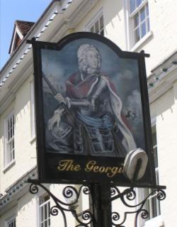
10 ... and a snapshot of Haslemere today Haslemere, which is twinned with Bernay, (in Normandy, France), and Horb-am-Neckar (Germany), has a population of about 15,600 residents. It is divided into five distinct areas which extend from Grayswood through the centre of Haslemere towards Wey Hill and Shottermill and on to Critchmere. The steep A287 road leads up to Hindhead and then on to Beacon Hill. The outskirts of the town are semi-rural, including the village of Grayswood. Focal points of development, of a more leafy suburban character, are Critchmere and Shottermill. These were originally separated from the town centre by farmland and woodland but have now, to a greater or lesser extent, become part of Haslemere whilst retaining a s p e c t s o f t h e i r individuality and relics of their natural or seminatural setting. The geographic location of Haslemere means that it is a Border Town (on the fringes of East Hampshire and West Sussex) as well as a Rural Market Town and its facilities are used by people from a wide catchment area. It is Christmas Market also now a northern gateway to the newly formed South Downs National Park. Anyone accessing this part of the national park by train would travel to Haslemere. Since the early 20th century the population has greatly increased, and a considerable housing density is largely concealed by the relief and wooded character of the land. Despite continued pressure for development, the sizeable gardens, hedges, mature trees and small open spaces give the central parts of the town their distinctive atmosphere which is greatly valued. These areas, however small, form a green matrix both visual and valuable for biodiversity. Those who live in the nearby villages (Camelsdale, Chiddingfold, Hammer, Lynchmere and Fernhurst) regularly come across the county border to make use of the town s many services and facilities, such as the hospital, health centre (which also has a branch in Fernhurst), leisure facilities, sports clubs, children s playgrounds, community centre, museum, shops and notably the railway station. Haslemere Hall also acts as a cultural centre providing top class films, opera, plays, musicals, lectures, etc for the whole area. There is a well-used Visitor and Local Information Centre, within the Haslemere Educational Museum, an award-winning foundation with collections of local, national and international significance. There are many active groups and societies in and around Haslemere which cater for a wide range of interests including education, sport, art and entertainment. A variety of walking groups enjoy the many local footpaths which take advantage of the countryside on our doorstep. Haslemere has built up an excellent reputation for the many interesting and attractive town events: a monthly Farmers Market, an annual Food Festival, Christmas Market and Carol Concert. The Charter Fair alternates with the Haslemere Festival each May. All these events are well supported by the local businesses and visitors attend from far and wide. High Street, just before the Food Festival W h i l s t t h e r e a r e t h r e e supermarkets in the area, Georgian Hotel on the High Street Waitrose in the High Street, and Tesco and the Co-Op in Wey Hill, many long-established, independent and specialist businesses in the town provide necessary services and goods for the community. 10 Section 2: What makes Haslemere Special and distinctive


11 Recently there has been an encouraging arrival of new shops and boutiques - ladies wear, sports equipment, a fishmonger and delicatessen / wine shop. In addition the town is served by a variety of hairdressers, banks, estate agents, chemists, and charity shops. There are three hotels, the Lythe Hill, Devil s Punchbowl and the Georgian House, which also provide health and fitness facilities to supplement the sports facilities at The Edge and Herons leisure centres. A choice of cuisine is available from the many restaurants in the High Street and at Wey Hill and coffee shops abound in the town centre. There are several churches covering various denominations and the many state and private schools set high standards and enjoy good reputations. Haslemere Hospital is a much valued institution with 30 beds and minor injuries and outpatients facilities. Lion Green Three Limes pavement Playground at Town Meadow Former Police Station The Edge High Street Lower Street Railway Station Haslewey Community Centre View across towards Haslemere 11 Section 2: What makes Haslemere Special and distinctive
 south-west of Guildford and is the most southerly town in Surrey.")

12 3. Geography of the Area Haslemere and Hindhead are situated in the extreme south-west corner of Surrey, adjacent to the borders of both Hampshire and West Sussex. The town is situated 15 miles (24 km) south-west of Guildford and is the most southerly town in Surrey. It is surrounded by natural beauty which is mostly owned by the National Trust, and covers over 1,600 acres (650 hectares). Woodland and heathland with steep hills and valleys encircle the district, consequently there is an abundance of wildlife. It is just over the northern boundary of the recently-formed South Downs National Park and is one of the gateway towns. Guildford N N Farnham Godalming Hindhead Cranleigh Haslemere Horsham Haslemere (black boundary) in the context of surrounding towns and Guildford Haslemere s landscape is heavily wooded Crown copyright and database right 2011 Ordnance Survey LA Crown copyright and database right 2011 Ordnance Survey LA Section 3: Geography of the area

13 AGLV AONB & AGLV Haslemere N South Downs National Park Crown copyright and database right 2011 Ordnance Survey LA Haslemere is sandwiched between protected areas of the South Downs National Park and an area which is designated both as an Area of Outstanding Natural Beauty and an Area of Great Landscape Value 13 Section 3: Geography of the area


 and Wey Hill shopping area both provide facilities for people living in Haslemere and the wider area, and have experienced recent intensification")

 do so through tunnels of woodland, with outlying houses concealed by")
14 4. Landscape and Natural Environment Haslemere lies in the south-west corner of Surrey, on the borders of Hampshire and West Sussex, partly in the Surrey Hills AONB. The characteristic landscape of the region extends over parts of the three counties. The town is surrounded by hills, with Black Down at 920 feet (280 m) to the south and Gibbet Hill at 894 feet (272 m) to the north. The southern branch of the River Wey originates beneath Black Down and tributaries of the rivers Rother and Arun also rise locally. Areas of woodland and heathland surround the town, many in the care of the National Trust. They are valuable for wildlife and informal recreation. As well as this mix of semi-natural habitats, there are small pockets of grazing land with hedges and belts of trees, and the older residential areas are characterised by gardens with large shrubs and exotic trees. The historic centre of the town (a Conservation Area) and Wey Hill shopping area both provide facilities for people living in Haslemere and the wider area, and have experienced recent intensification of development and improved decorative planting. Other villages and hamlets cluster within a short distance of the main centre. The town has a distinctive character with many unique features, much valued by the inhabitants. It is desirable to preserve this in the face of continuing population pressure. Haslemere should not be fossilised, but can look forward to a vibrant future if quality and sensitivity is ensured for new development. Boundaries and Approaches Haslemere approach roads (Midhurst Road, Petworth Road, Grayswood Road, Hindhead Road and Liphook Road) do so through tunnels of woodland, with outlying houses concealed by trees. These roads are mainly hilly. The nearby hamlets and villages of Hammer, Camelsdale, Hindhead, Critchmere and Grayswood are only tenuously separated from the main town, yet the outskirts are semi-rural overall with woodland, broken with the occasional garden. Haslemere is unusual in that completely undeveloped open land penetrates closely into the town, due in part to historic patterns of land ownership, especially that of the National Trust. These green fingers of damp woodland and small fields with adjacent hedgerows (such as along Bunch Lane and at Swan Barn) are immensely valuable and characteristic, and protecting them is to be strongly encouraged. View over the town from Shepherds Hill Petworth Road, entry from the south east Belted Galloway cattle grazing at Swan Barn Summer mist over Black Down Approach to the town from north along Approach to the town from south along Grayswood Road Shepherds Hill 14 Section 4: Haslemere landscape and natural environment


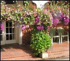
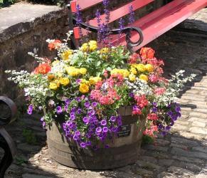
15 Planting and Open Spaces In the more formal areas well maintained planters and decorative beds are appropriate to add colour to the scene. Lion Green, St Christopher s Green, Town Meadow and other visually significant areas of green space contribute to the quality of the urban environment. Where natural vegetation survives, sensitive management can preserve its value to wildlife as refuges as well as provide food plants for insects and birds. Rather than being regarded as unkempt, these areas can be seen as contributing to biodiversity, and arresting the decline of wild habitats. Clement s Corner a community project Open Spaces Design Guidelines: Provide a range of public open spaces, including both wild areas and small open grassed spaces, to promote vibrant streets. Maintain low-key public open spaces appropriately to conserve wild flowers and biodiversity. More formal tree or decorative planting is appropriate to shopping streets. Introduce tree planting to break up large areas of car parking Preserve the existing lines for High Street frontages and encourage the use of the wide pavements for café or similar social activities Green spaces within Haslemere are part of the character and charm of the town and these should be retained Flower beds at Wey Hill Town Meadow Lion Green at Wey Hill Relief and Visual Landscape Haslemere has grown up around a series of ridges and valleys, with wooded slopes too steep for development. The appearance of the town has benefited from the screening of this relief and vegetation. Viewpoints entering and within the town are often framed by trees and garden plantings. There are many points in the surrounding countryside from which wide vistas of woodland and extensively grazed fields can be seen, and it is readily appreciated that this part of Surrey is one of the most densely treed. Some of the valued landmarks and viewpoints nominated by residents are Black Down, Marley Heights, Swan Barn, Grayswood Common, and from the Devil s Punchbowl and Hindhead Commons down to Polecat Valley. It will be important to consider shorter distance local views in reviewing proposals for new development. 15 Section 4: Haslemere landscape and natural environment
 a r e c h a r a c t e r is e d b y d r y heathland vegetation, and comprise the Wealden Special Protection Area.")

16 Natural Environment and Wildlife The more elevated areas of land in and around Haslemere (Thursley, Hankley and Frensham Commons, Devil s P u n c h b o w l e t c. ) a r e c h a r a c t e r is e d b y d r y heathland vegetation, and comprise the Wealden Special Protection Area. While these and other l o c a t ions a r e r e a d il y accessible, public access may need to be carefully managed to avoid damage to sensitive habitats. At points, where the G r e e n s a n d o v e r l i e s impermeable clays, springs e m e r g e c r e a t i n g t h e contrasting but equally characteristic damp ground conditions. These small streams form tributaries of the rivers Wey, Arun and Rother. View from Black Down, looking west Surrounding the town there Heather on Hindhead Common are large areas of both damp and dry woodland and heathland. Between developed areas, trees and scrub of mainly indigenous species form wildlife corridors. It is desirable to limit intrusion of development into remaining areas of natural habitat, especially that of noise and light pollution which can disrupt wildlife. Mature trees and ancient woodland are particularly valuable, supporting large numbers of species, some rare or threatened. Established hedges of native species form corridors where wildlife can shelter and travel. Once fragmented this network would not be regenerated within a lifetime. Haslemere may be unique in Surrey in having such a range of wildlife surviving in close proximity to the town centre, albeit in small numbers. It is hoped that this privilege, resulting from the retention of woodland surroundings, will continue to be a feature. Further guidance on local natural environment policies can be found in the Local Character Assessment on Surrey County Council s website. Natural Environment Design Guidelines: Seek to maintain and enhance tree and hedgerow cover on boundary lines of development sites to screen new schemes and reflect the local landscape character within and around the town Preserve the tree and hill skyline views across the whole of Haslemere Encourage developers of large volume buildings to provide extensive tree screening Reflect the distinctive nature of different landscape character areas within the town appropriately in new development Protect important vistas into, within and out of the town, particularly the local characteristic of undulating treecovered hillocks. These conceal much of the developed area of the town, and create the tunnel-like tree and hedgelined roads and lanes Preserve, enhance and manage existing hedgerows, green lanes and unmade lanes e.g. Farnham Lane and Bunch Lane New trees and hedges should be native species or appropriate local or traditional fruiting varieties, more valuable to wildlife Maintain, enhance and extend wildlife corridors. Footpaths should be surfaced to reflect the local natural environment 16 Section 4: Haslemere landscape and natural environment


17 5. Transport and Access Rail: The railway station is a transport hub providing a regular commuter service to London Waterloo, with a journey time of less than an hour. Its importance as a point of arrival for visitors and a more sustainable mode of transport needs to be recognised. Haslemere should be promoted as a gateway to the new South Downs National Park. Haslemere has little in the way of industry and its success rests largely on it being a popular place to live for those who commute to jobs elsewhere. The railway is, therefore, vitally important and will become increasingly crucial in future, particularly with access to the station improved by the removal of bottlenecks at Hindhead. The infrastructure supporting the station is Railway line approaching Haslemere thus paramount, especially in the context of the approved 330 home development at Easebourne (King Edward VII Hospital), the proposed eco town of Whitehill / Bordon and the substantial development proposal 5 miles away in Fernhurst (Syngenta site). Roads: The A287 runs southwards from Hindhead, joins the A286 from Milford, and continues southwards to Midhurst. The B2131, the main road through town, links Haslemere to Chiddingfold and Petworth to the east and Liphook to the west. Wey Hill connects the two main areas of the town, partly paralleled by the railway. The A286 carries the bulk of the north / south traffic and has many tortuous bends. The east / west B2131 is fundamentally unsuited to large articulated vehicles and buses due to the bends of Petworth Road, the width constraints of Lower Street and the railway bridge by Weydown Road. However it is used by these to service the local population needs. Traffic projections by the Highways Agency suggest large lorries will tend to use the newly opened A3 tunnel rather than negotiate Haslemere High Street, but the town continues to attract both commuter and domestic traffic. Many parts of Surrey retain clear evidence of its rustic and rural past and Haslemere is, because of its hilly topography, a place where the narrow roads and steep banks have provided powerful restraints on greater development. The roads are, in the main, simply asphalted versions of medieval tracks. Many small lanes and newer access roads criss-cross between these main arteries, providing access to housing areas. Some smaller lanes can be considerably compromised by traffic, which has been a longstanding detractor from the quality of the environment throughout the town. Paths: The Greensand Way and Serpent Trail (long distance footpaths) and a further extensive footpath network allow pedestrian access through the town and out to open areas. Transport and Access Design Guidelines: Alleyway beside 10 High Street Road, footpath, parking and landscape design should relate to the existing surrounding features in terms of layout, features and surface finishes Road widths, layouts and surfaces should be designed to limit drivers speeds and reduce visual impact A variety of carriageway widths, shared space, passing places, surface treatment, speed reduction features, road edge and footpath design should be encouraged within new developments Parking spaces and garages should be integrated with the building design Small lanes and alleys are characteristic of the town centre and should be maintained and incorporated into new development The green corridor entry points into the town should be safeguarded. 17 Section 5: Transport and Access
18 6. Design and Architectural Guidance The following Design Guidelines are proposed to apply to all areas of Haslemere. They are intended to enhance and maintain the character and scale of the area. Principles applying to specific parts of Haslemere are identified in the section Design Guidance Design and Architecture Design and Architecture Design Guidelines Development of retail and business premises, including car parks, should be appropriate to the existing character of the town in terms of scale Proposals for new buildings should relate to their sites and surroundings, and should be sympathetic to the protection of the rural environment; within this context variety in scale and texture is encouraged to add interest to the street scenes Heights of buildings should relate to the scale of the adjoining properties and the street scene, and should be designed to respect existing vistas Contemporary designs should be of high standards and complement their context and, where possible, enhance adjoining properties. These add interest and character to the street scene Garden land and infilling developments should only be permitted when there is garden area appropriate to new and existing dwellings there is adequate off-street parking they do not have a detrimental impact on the existing character of the area or local biodiversity Significant buildings of architectural interest may warrant inclusion as buildings of local merit Design and Architecture Design Guidelines (continued) Where new development is proposed, imaginative solutions should be found, to achieve higher density without undermining the character of the existing area Care must be taken to ensure that any new development sits well in the street-scene and the form of any new development must be appropriate for the site in which it sits The impact of new development should be carefully considered, to avoid undue pressure on the existing infrastructure, given the constraints of the topography. New development should consider carefully the traffic implications associated with additional vehicle movements New development should provide for safe movements of vehicles and pedestrians New development should encourage the use of public transport and, bearing in mind the contours of the district, encourage the use of bicycles All new development should provide adequate off-street parking appropriate to a small market town Vehicular access to individual properties should be designed to enhance the street scene Extensions should be carefully considered, to reflect the style of the original dwelling and to avoid having an adverse effect on the street-scene Encourage irregular-shaped car parking areas interspersed with features, structures and planting and with innovative surface treatments. Large monolithic regular car parking areas devoid of planting and features of interest should be avoided. Continued.. 18 Section 6: Design and architectural guidance


 The colour palette of shop fronts should reflect the")

19 Design and Architecture Design Guidelines (continued) Where front gardens are used for car parking, solid paving should be kept to an absolute minimum and permeable materials should be used Residents should be encouraged to incorporate some landscaping into parking provision on front garden space, to maintain a green aspect in the street scene Paved areas should be appropriate to the site. In general plot boundaries should be defined with traditional walls, fences or hedges appropriate to the character of the area New development should consider appropriate siting, screening and storage of residents refuse and recycling bins Trees, hedges and wide verges are an essential feature of the area and residents should work with planners, in order to maintain their number and variety Tree-lined avenues should be retained and enhanced New development should make provision for street loading bays for deliveries where possible TV receiver dishes, solar panels, solar thermal panels etc should be sited to minimise their visual impact Ensure the use of good quality materials and finishes to shop fronts (see Appendix 2) The colour palette of shop fronts should reflect the context of the area. Where shop fronts and signs are within a historic street, a traditional colour palette and finish should be used. Rich, dark colours with a matt finish often look very good leaving window displays and lettering to provide accents. Whatever the context, colour schemes adopted should be subtle and blend harmoniously with the environment Examples of buildings exhibiting good design principles for the time when they were built Lion Lane Collards Gate Trout Road Lythe Hill Park 19 Section 6: Design and architectural guidance
, the Georgian House Hotel, the White Horse Hotel and, close to the parish church, Church Hill House (early 18 th century)")


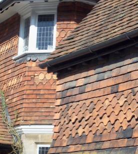
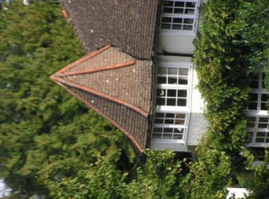
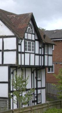
20 6.2 Traditional local design / vernacular The oldest buildings in Haslemere were built of Bargate stone and later, brick. Few eighteenth century buildings can be found but the Town House (circa 1725), the Georgian House Hotel, the White Horse Hotel and, close to the parish church, Church Hill House (early 18 th century) are good examples. Another is the Town Hall in the centre of the High Street, built in 1814 and altered in 1870 but looking a hundred years older. Bargate stone wall with ironstone galletting in St Christopher s Church Tile hanging, the High Street Wooden window frame, Courts Mount Road Dormer window, the High Street Local Vernacular Design Guidelines Any new building or extension in the area should complement the local vernacular style Match, where possible, local materials Replacement windows should appear much the same as their predecessors, be it in metal or timber UPVC windows may be acceptable if they blend in with the prevailing style of neighbouring properties Doors and porches should be similar to those of their neighbourhood Haslemere traditionally uses tile-hanging as a wall cladding to the upper storeys of properties and this practice should be continued in appropriate locations Where appropriate and in keeping with the street scene, pitched roofs should preferably be pitched at not less than 45 degrees, providing they tie in with the existing building Dormer windows should, where appropriate, be of traditional construction, with pitched roofs and tile-clad flank walls Where new buildings are intended to maintain a particular stylistic tradition it is important that this is consistent and the design shows a proper understanding of the tradition. Details such as eaves, chimneys, window openings, external joinery and porches all play a large part in that tradition New buildings should respect and respond to the context of the site. They need not imitate the buildings in the vicinity but if they do then care should be taken to fully understand and replicate detailing especially at roof eaves, verges, ridge, hips and valleys. 20 Section 6: Design and architectural guidance


21 6.3 Sustainable building design Haslemere is an attractive, well-preserved town set in a particularly beautiful part of the country, and has a thriving community and local economy. However, the town faces a number of challenges in the future with climate change and global and local competition for natural resources, such as oil, water and land. As pleasant and prosperous as the town currently is, it will not be immune to the effects of these issues in the years to come. Therefore, it is important for the town to bear in mind its contribution to factors such as climate change, and to ensure that development and design decisions in the future promote the long term sustainability and resilience of Haslemere. This means giving a high priority to energy efficiency, the use of sustainable materials and consideration of the natural environment and biodiversity in new developments, as well as encouraging the local economy and a greater degree of self-sufficiency. National guidelines are set out in Appendix 1. Energy efficiency Houses produce 27% of Britain's carbon emissions. Energyefficient homes cost less to heat, an important factor with escalating fuel prices. Improving the energy efficiency of houses and other buildings is one of quickest, cheapest and most effective ways of reducing the community's carbon emissions, while at the same time improving the comfort, value and cost of running buildings. Therefore, measures should be taken to upgrade existing buildings to higher energy efficiency standards, including incentives and assistance. Examples of integrated solar photovoltaic panels Measures could also include the provision of thermal imaging surveys (to identify energyinefficient buildings and parts of buildings) along with energy performance audits and advice on the most cost-effective actions appropriate to particular properties. Local renewable energy production should be encouraged and supported, both for homes and for larger premises. Given the woodland nature of Haslemere's environment, wood biomass heat production is a natural option. Solar thermal panels for providing hot water are relatively costeffective, particularly when fitted as part of new builds and extensions. New buildings should be designed to allow solar panels and any other alternative technology to integrate with the overall form rather than appear as a retrofit. If retrofitting alternative technologies to buildings in conservation areas these should be placed in the most inconspicuous places or perhaps on ancillary buildings such as glasshouses, sheds or garages. The protection of the historic environment can help in reducing Solar photovoltaic panels on a glasshouse energy waste. The retention and reuse of historic buildings is more sustainable in terms of material and energy costs when compared to demolition and new development. The close physical relationship of buildings with residential, commercial and leisure uses is a key feature of historic areas and provides a sustainable form of living. This can be used to inform the layout and mix of new development. Energy-efficiency considerations should include the whole-life energy consumption of the building or extension. This includes the embodied energy of the materials used, as well as the ongoing energy consumption of the property. This argues for the use of locally-sourced, renewable and sustainable materials wherever possible. It also implies an awareness and perhaps a monitoring of the performance of buildings over time to ensure the energy-efficiency potential is not subverted by wasteful behaviour. In this context, the development of the Speckled Wood Volunteer Centre by the National Trust at Swan Barn provides both a local and national 21 Section 6: Design and architectural guidance


22 model of sustainable d e s i g n a n d development. It is being built almost completely with locally-sourced, sustainable materials, including oak, coppiced chestnut, clay and hay (for hay bale walls). The Centre has high levels of insulation and is heated by a biomass burner fed by wood from National Trust properties. It also has NT s Speckled Wood eco-building at Swan Barn solar thermal panels for water heating. In addition, the Centre will produce some of its own food, with the help of a chicken run, a vegetable garden and a beehive. Biodiversity The impact on the natural environment and local biodiversity should be taken seriously in the consideration of planning applications. Haslemere has a rich and diverse natural environment and is the home to a wide variety of flora and fauna, including a number of endangered species such as great crested newts and various bat and plant species. To maintain this biodiversity, wildlife corridors, as well as areas of meadow, woodland and other informal spaces, should be preserved. Lighting Excessive lighting and light pollution should be avoided to preserve and enhance local flora and fauna, as well as the semi-rural nature of the town and the night sky and so maintain the distinction between the countryside and the town. Pair of eco-houses behind Wey Hill Examples of solar thermal panels for water heating: integrated (left) and retro-fitted (right) Thermal image of a window, the brighter areas being places of greatest heat loss. The left hand image is with secondary glazing and the right hand image shows the same window after double glazing was fitted 22 Section 6: Design and architectural guidance


23 23


24 7. Designs for your neighbourhood Generic design guidelines, which apply throughout the town, are set out in the preceding sections. They should be used together with the specific guidelines of this section. History of Haslemere a brief history There is evidence of human occupation of the area around Haslemere from pre-historic times. The Norman church of St Bartholomew is the oldest surviving building, dating back to In the twelfth century there was a Chiddingfold family named Heysulle and it has been suggested that the name Haslemere refers to the boundary or mere of the Heysulle family land. At that time Haslemere was part of the borough of Godalming and had originally been given by Henry II to the then Bishop of Salisbury in The first mention of Hindhead or Hyndehed came in 1571 with the explanation that it was a hill frequented by hinds or does. Haslemere s importance continued to grow and a Charter was granted by King Richard II in 1394, permitting the holding of a weekly market. Following this, industries were set up and the town became known for glassmaking, iron ore smelting and leather curing, as well as farming. This brought wealth and prosperity to Haslemere which then View of Haslemere High Street early 20 th C. Copyright Francis Frith collection received Borough status and the right to elect two Members of Parliament from Queen Elizabeth I. In 1596 she visited the town and granted it a new Charter which sanctioned the market and two annual fairs. To this day Haslemere still holds a Charter Fair in the High Street on alternate (evennumbered) years Tithe map of central Haslemere showing railway and town centre During the 16 th C to 18 th C Haslemere became an industrial centre for small scale iron-working and craft industries, but fundamentally it remained a rural town until the mid 19 th century. The opening of the London to Portsmouth railway in 1859 changed Haslemere forever. From being a remote little town, accessible to the outside world only on horseback or by gig, it could now be reached from London in under an hour and a half. Change at first was quite slow but the increasing number of visitors gradually built up a demand to live in this attractive area. In the years between 1895 and 1910, Haslemere came into its own architecturally: Lutyens at Amesbury School, Voysey at New Place, Farnham Lane, and E J May at both Branksome Hilders on the Hindhead Road and Ballindune in Weydown Road. Other houses of merit are Kemnal on the Grayswood Road and Hill Court in Courts Hill Road, both by Norman Shaw, and, possibly one of the finest houses in the district, Broad Dene, Hill Road, by W F Unsworth and Inigo Triggs. 24 Section 7: Designs for your neighbourhood: History of Haslemere

25 Areas of Haslemere Conservation Area N Haslemere South of Town Centre Haslemere North of Town Centre Grayswood Shottermill & Critchmere Special Green Areas Industrial Areas Hindhead & Beacon Hill Crown copyright and database right 2011 Ordnance Survey LA For general design guidelines applying to all areas see sections 4, 5 & 6 25 Section 7: Designs for your neighbourhood:


26 Sir Jonathan Hutchinson s great contribution to the town was the founding of its Educational Museum in Now sited in the High Street, it is one of the most highly-regarded museums in the country. Other benefactors to the town include Stewart Hodgson, who, among his many philanthropic works, gave generously to St Bartholomew s Church, built the Comrades Club and modernised the Town Hall. Barclay Day made his name locally by building the Haslemere Hall, the 350- seat theatre in constant use today. At the turn of the century Haslemere was in the forefront of the revival of the Peasants Arts and Crafts movement with s p i n n i n g, w e a v i n g, woodworking and pottery taking place around the town. Haslemere was then truly on the map and, with London within easy reach, more and more people wished to live here. House b u i l d i n g t h e r e f o r e increased rapidly and the population grew year on year. Haslemere Museum Kemnal, Grayswood Road The reorganisation of local government in 1974 resulted in Haslemere becoming part of the Borough of Waverley. The former Urban District Council became known as Haslemere Town Council, led by a Town Mayor. Art deco decoration at the bottom of Shepherds Hill Decoration on front of Haslemere Comrades Club Amesbury School by Lutyens Plaques on cottages in Lower Street For general design guidelines applying to all areas see sections 4, 5 & 6 26 Section 7: Designs for your neighbourhood: History of Haslemere

27 7.1 Area 1: Haslemere Conservation Area Detailed map of Haslemere Town Conservation Area as of 2006 Crown copyright and database right 2011 Ordnance Survey LA For general design guidelines applying to all areas see sections 4, 5 & 6 27 Section 7: Designs for your neighbourhood: Town Centre Conservation Area


 and Swan Inn (above) Collards 55 High Street Inscriptions from inside Lloyds Chemist For general design guidelines")
28 The Conservation Area is characterised by: Medieval T-shaped pattern of the High Street, Lower Street and Petworth Road, with the Georgian Town Hall at their junction Historic and distinctive buildings, varying in age from the medieval to early 20 th C, lining the High Street and the various ancient routes entering the town: Shepherds Hill, Lower Street, Petworth Road and Sandrock Backcloth of densely wooded hillsides Proximity of National Trust meadows and woodland east of the High Street Town Meadow is an important recreational area on the edge of the old town centre Vibrancy of the High Street and West Street as the retail and social heart of the town with street cafés, pubs and high-quality independent shops Many historic buildings with a variety of local vernacular details surviving in their irregularly-shaped, and very often, small plots. Half Moon House is a typical example Haslemere Town Centre Conservation Area description The Conservation Area runs alongside the principal streets and routes leading to and from the historic Town Centre (High Street). It is along these routes that some of the oldest and most distinctive properties within the town are found. In 2005 the Conservation Area was extended to include the western side of Sandrock and part of Courts Hill Road and Courts Mount Road. The Conservation Area is characterised by Buildings on the High Street which retain some of their original form: The White Horse Inn and The Swan Inn, both early 1700s Premises occupied by Lloyds Chemist, from about 1620 White Horse (left) and Swan Inn (above) Collards 55 High Street Inscriptions from inside Lloyds Chemist For general design guidelines applying to all areas see sections 4, 5 & 6 28 Section 7: Designs for your neighbourhood: Town Centre Conservation Area


29 Several other buildings dating from around the 16 th -17 th C further up the High Street but they have new frontages Arts and Crafts style buildings, for example Angel Buildings, a pastiche of the medieval building style. Close up of Angel Buildings Lower Street is the busy old entry route into the town centre from Wey Hill. Architecturally mixed and reflects the organic growth of the town: South side has a row of 17 th C and 18 th C cottages with many interesting features including the local hand-made fishscale tile hanging and evidence of wooden glazing bars North side is predominantly Victorian terraced houses Yew Tree Cottage dates from the late 15 th C or early 16 th C Typical fish-scale roof tiles Half Moon House, next to Lloyds TSB bank, from 16th C Haslemere Comrades Club Town House, High Street 24 High Street Mixed styles on Lower Street For general design guidelines applying to all areas see sections 4, 5 & 6 29 Section 7: Designs for your neighbourhood: Town Centre Conservation Area


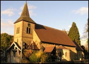
30 The southern edge of the Conservation Area is defined by ancient routes i.e. Shepherds Hill and Petworth Road: The oldest properties are the timber-framed buildings of the 15 th C and 16 th C. Haslemere Design Statement T erraced cottag es of Shepherds Hill are late 17th and 18thC, of brick and with roofs of locally-made clay tiles and natural slate. These are sited high above the A286 and the town. The Conservation Area extends to the north and north west to the vicinity of St Bartholomew s Church. Notable buildings in this area: Little Barn, Church Lane, a late 17 th C Grade II listed building Parish Church of St Bartholomew, with a frontage on to Church Green, dating to 16 th C. The bell tower is the only remaining part of the original building The church has memorials to many prominent residents including Alfred, Lord Tennyson View along Shepherds Hill cottages Little Barn, Church Lane Late 19 th C walls and wooden lych-gate around the churchyard are Grade II listed Church Hill House, a Grade II listed Queen Anne house, with the earlier Church Hill Gate, dated 1589, attached to its left St Bartholomew s Church The Conservation Area was extended in 2005 to include the northern edge of Courts Hill Road and Sandrock. The character of this area is defined by: A core of old buildings, all of which have been modernised. Where extensions have been added, the work has been carried out with great care and sensitivity The spine of the area is the narrow ancient drove road, Sandrock Little Sandrock Cottage, dating from late 17 th C, standing on the corner of Courts Mount Road. Church Hill House Penfolds on Sandrock After World War l the area known as Water Tower field (now the Recreation Ground ) was acquired to create a lasting memorial in the form of playing fields for the people of Haslemere. For general design guidelines applying to all areas see sections 4, 5 & 6 30 Section 7: Designs for your neighbourhood: Town Centre Conservation Area
31 Design Guidelines for Haslemere Town and Conservation Area Generic Design Guidelines also apply in relation to any development in this area and these are stated in context in sections 4, 5 & 6 and Appendix 1. The complete set of guidelines can be found in Appendix 8. Preserve and enhance the character of the Town Centre Conservation Area by ensuring that the scale, design and proportions of new buildings responds to and respects the existing historic features. Space around development is of as much significance as its architecture Modern design that compliments and responds to the historic character of the conservation area may be considered acceptable Protect the variation of frontages in High Street, West Street and Petworth Road; encourage use of wide pavements for café or similar social activities Respect the fabric of buildings and their surroundings when new uses are developed for existing buildings and alterations are undertaken Give preference to proposals for restoration and conservation of older buildings worthy of retention rather than demolition and re-development Any extensions or alterations to buildings should complement the existing detail, materials and built form of the houses Retailers should follow WBC s Shop-Front Design Guide, see Appendix 2 Retailers should adhere to the present policy of resisting all projecting internally-illuminated signs and fascia signs within the Conservation Area Ensure the use of appropriate materials and finishes; retain existing character features such as shop-fronts and windows Take steps to avoid the proliferation of advertising hoardings, even if only of a temporary nature, where they impact adversely on the overall street scene Retain and enhance the pedestrian passageways / alleys and links between streets and car parks throughout the town centre and create new links when the opportunity arises Retain at least the façade of the Police Station as an important contributor to the local built environment Street furniture should be of a high quality and of a single heritage design and appropriate colour. All highway interventions should respect the character of the conservation area and where practicable enhance this character through sensitive traffic management and decluttering. Signage should be kept to a minimum and proven use to avoid confusion, clutter and damaging visual impact. For general design guidelines applying to all areas see sections 4, 5 & 6 31 Section 7: Designs for your neighbourhood: Town Centre Conservation Area


 have seen more modern infilling There has been a marked increase in extensions so that many houses now fill their frontages Many older properties have been")


32 Area 2: Haslemere, South of Town Centre This area is characterised by: A variety of housing in age, size and style ranging from large country houses in substantial acreages to smaller terraced properties and apartments Large Victorian houses in large plots Other Victorian and post-war houses in smaller plots Many houses are individually designed Half Moon Estate built about Houses, both detached and semidetached, have strong architectural features such as turrets, pebbledash elevations, large chimneys and the discreet use of tile hanging. It should be considered for Conservation Area listing There has not been significant post-war housing developments except for the western end of Scotland Lane, Scotland Close, Lythe Hill Park and, most recently, Meadowlands Drive The roads where houses previously had larger gardens (e.g. Park Road, Hedgehog Lane) have seen more modern infilling There has been a marked increase in extensions so that many houses now fill their frontages Many older properties have been sensitively modernised and extended Park Road Several small private roads, each serving four to seven houses, mostly entirely hidden from the public roads. They are generally of Victorian to post-war age Building material is predominantly brick, with a variety of elevation treatments, including rendering, and most having tiled roofs Traffic and parking are issues due to proximity of the heavily-used railway station, especially in Longdene Road, Courts Hill and Courts Mount Roads Steep hillsides - many houses have commanding views over the town and beyond High number of mature trees in gardens contribute to the impression of a rapid transition from town to country Surrounded by National Trust woodland and adjoining the South Down National Park which limit further developments. Allotments at Collards Lane Edwardian house on Hill Road View down Museum Hill Howberry Chase For general design guidelines applying to all areas see sections 4, 5 & 6 32 Section 7: Designs for your neighbourhood: South of Town Centre


33 Design guidelines for Haslemere: South of the Town Centre Generic Design Guidelines also apply in relation to any development in this area and these are stated in context in sections 4, 5 & 6 and Appendix 1. The complete set of guidelines can be found in Appendix 8. In areas of family housing with proportionate gardens, the design of infill development should retain the local character. Space around development is of as much significance as its architecture Wide grassy verges are a key characteristic of this area and should be designed into new developments Extensions and annexes should be well-designed and screened for minimum impact on the visual amenity of the area Lythe Hill Park House on Scotland Lane Chase Lane, Chase Farm Gabled houses on the Petworth Road Petworth Road, Almhouses Petworth Road, Courts For general design guidelines applying to all areas see sections 4, 5 & 6 33 Section 7: Designs for your neighbourhood: South of Town Centre


34 Area 3: Haslemere North of Town Centre This area is characterised by: A variety of housing in age, size and style ranging from large country houses in substantial acreages to smaller terraced properties and apartments Examples are: 17 th C Grade II listed Manor House, Three Gates Lane C a r v e r s a n E l i z a b e t h a n - s t y l e country house, lying in 11.5 acres (4.7 hectares) of land A number of larger country Three Gates Lane, Manor House houses have been split into wings or apartments and the grounds subdivided to provide further housing. Some have been converted into residential care homes Infilling over the years with the new houses being individually and sensitively designed Several small private lanes mostly entirely hidden from the public roads. For example Kemnal Park, a turning off Three Gates Lane, comprises 22 properties all in largish plots and very popular family homes. Most were built around the 1950s and are in traditional Haslemere style On either side of the A286 Grayswood Road are further sizeable houses of mixed ages and all with good front gardens which contribute to the rural feel of this entry into the town Weydown Road and Derby Road contain some of the largest houses in the town. Most houses date from the early part of the 20 th C The area is strictly controlled by two measures: Lord Derby s Restrictive Covenant requiring each property to have at least 0.75 acre plot (0.3 hectare) W BC s identification of Weydown Road and Derby Road a s Low Densit y Residential Policy BE6 Traffic issues at the eastern end of Derby Road and top of Church Road with schoolr e l a t e d t r a f f i c f o r S t Bartholomew s Primary School and commuter parking High Lane contains a mix of houses large and small, with Oak Garth and The Garth being Grade II listed buildings of red brick with tall chimneys, designed in the late 19 th century by local architect, J W Penfold Pine View Close, a distinctive road with individual detached properties of the 1930s, many subsequently extended Behind these houses lies a long drive to Oak Hall, another grade II listed building. It became a school (Wispers) which finally closed in Currently it is being developed into a retirement village. High Lane Estate: A local authority estate built in the 1950s, many of the houses now owned privately View of Weydown Road Weydown Road, Ballindune High Lane Estate For general design guidelines applying to all areas see sections 4, 5 & 6 34 Section 7: Designs for your neighbourhood: North of Town Centre


35 Far-reaching views and spacious layout. It is widely thought to be one of the best social housing estates in Surrey. Car parking is an issue Kiln Avenue built in 2005: many red-brick houses and flats with small gardens, all with eco-friendly features High Lane Community Centre, the design of which sits uncomfortably within its surroundings A few small roads of private housing Fieldway, high-density housing, some of which was previously owned by Waverley Borough Council Popesmead was built in 1905, with Bridge Road and Fieldway following. These are in local traditional style with brick and tile and some timbering. The Haslemere Hall, the hub of culture in the town, dating from 1913 and subsequently extended at the side Kiln Avenue High Lane Community Centre The former St Bartholomew s Haslemere Hall primary school now houses a nursery school, with the back wing used by the Haslemere Players. Around both sides of the former school playground, a group of town houses, St Bartholomew s Square, was built in the mid- 1990s Further local authority housing, some of which is specifically for older residents, can be found in George Denyer Close and at the far end of Fieldway. Redwood Manor Former St Bartholomew s primary school George Denyer Close Design guidelines for Haslemere: North of the Town Centre Generic Design Guidelines also apply in relation to any development in this area and these are stated in context in sections 4, 5 & 6 and Appendix 1. The complete set of guidelines can be found in Appendix 8. Trees, hedges and wide verges are an essential feature of the area, these should be maintained and incorporated into the design of new developments For general design guidelines applying to all areas see sections 4, 5 & 6 35 Section 7: Designs for your neighbourhood: North of Town Centre


.")


36 Area 4: Grayswood History of Grayswood The settlement of Grayswood had its own distinct identity as a village until the turnpike was created in 1756 when the road layout we know today came into existence. Prior to that, the cross roads formed where Haslemere High Street meets Three Gates Lane on one side and Church Lane on the other was simply a T-junction with those two lanes. With the Turnpike Act, the old forge which existed at the top of the High Street was demolished and the road to Grayswood came into being. G r a y s w o o d v i l l a g e originally was a very modest place with a few scattered cottages forming part of the farming community and one or two more substantial dwellings owned by yeoman farmers in the village itself. Grayswood now is a quintessential English village with a thriving pub, church, school, club, village green and a new village hall (one of the first public buildings to be provided by lottery funding). There is a strong sense of community and residents are proud of their d e t a c h m e n t f r o m Grayswood Church Grayswood, White House Haslemere. The feeling of identity shared by Grayswood people is probably engendered by a number of things: the village cricket club is one, but probably the scale of the village is a more significant factor. Surrounded by land owned by the National Trust and the Forestry Commission, which all forms a part of the Surrey Hills AONB, there are planning constraints upon further development. Another property of interest is The White House, an architectural gem in the Modernist style, built in The heart of the village probably lies between the Wheatsheaf Inn and the primary school where a line of late Victorian cottages along Lower Road provides much of the residential core. This nucleus is supplemented on The Mount, near the church, and a few large houses and farms in the hills nearby. The largely post-war linear development along Clammer Hill tends to reflect more the national style than local distinctiveness. Grayswood Village Hall Grayswood Wheatsheaf Grayswood, Grayswood Farm For general design guidelines applying to all areas see sections 4, 5 & 6 36 Section 7: Designs for your neighbourhood: Grayswood

, designed by Axel Haig (1902) White House, a rare and outstanding example of Modern Movement architecture in this part of Surrey, dating from 1932")


37 Grayswood is characterised by: Cohesive rural village community, which values its separate identity Clustered nucleus of Victorian cottages along Lower Road Many enclosed front gardens have been opened up for parking Larger houses around the edge Some more recent developments along Clammer Hill and behind the Wheatsheaf Inn Ribbon development along the Grayswood Road and Holdfast Lane, some Victorian (Klondyke Villas of 1896/8) and more modern houses Only Swedish Gothic Church in Surrey (possibly England), designed by Axel Haig (1902) White House, a rare and outstanding example of Modern Movement architecture in this part of Surrey, dating from 1932 and grade II* listed. Design guidelines for Grayswood Generic Design Guidelines also apply in relation to any development in this area and these are stated in context in sections 4, 5 & 6 and Appendix 1. The complete set of guidelines can be found in Appendix 8. Any new building should respect the character of the village, its topography and features while respecting the views and vistas of the locality Design and choice of materials should integrate with the existing uniformity of design of the Victorian terraces Any new development, together with alterations and extensions, should be of high standard, complementing the existing and adjacent buildings The scale and building height of new developments should be consistent with the character of the existing street scene Grayswood Cottages Grayswood Club and its plaque Grayswood, Lower Road Grayswood Old Post Office For general design guidelines applying to all areas see sections 4, 5 & 6 37 Section 7: Designs for your neighbourhood: Grayswood


38 Area 5: Shottermill and Critchmere History of Shottermill and Critchmere For 700 years a small isolated community in the Wey Valley, now known as Shottermill and Critchmere, was a corner of industry; by the end of the 19 th C six watermills existed, used for corn milling, fulling, iron-working and, in particular, sickle making, leather dressing, paper and braid making. The coming of the railway to Haslemere in 1859 brought increased prosperity in the town, with many large houses and country estates being built in the hills approaching Hindhead. This brought a number of prominent Victorian and Edwardian people to the area, which in turn prompted development in Shottermill and particularly Lion Lane for the workers on the various estates. With the geographical and land constraints on development within the Town Centre, the development of Shottermill and Critchmere continued right through the 20 th C. Although much of housing in Shottermill and Critchmere was constructed from the mid/late Victorian era, a number of properties pre-date that time, mostly clustered around the junction of the A287 / Liphook Road / Church Lane. Examples include Rose Cottage, Cherrimans, Lees Cottage, Blossom Cottage and Buffbeards. All these are Grade II listed. There is a Voysey-designed house called New Place on Farnham Lane and Branksome Hilders, now a Muslim training school, which are also listed. One of the joys of Shottermill and Critchmere is the great v a r i e t y o f housing and landscape. They range from large country houses to housing of high density. The l a n d s c a p e changes from the Branksome Hilders on the Hindhead Road N a t i o n a l T r u s t Greensand Hills of Hindhead to the clays a t t h e l o w e r levels adjoining a tributary of the River Wey, a diverse area indeed! St Christopher s Church Lees Cottage Hindhead Road, Buffbeards Rose Cottage St Stephen s Church For general design guidelines applying to all areas see sections 4, 5 & 6 38 Section 7: Designs for your neighbourhood: Shottermill and Critchmere


39 Shottermill and Critchmere This area is characterised by: Development northwards from its medieval craft industry origins, which used the natural resources of the locality, to the predominantly residential area of today A considerable amount of Haslemere s development over the last fifty years has been in this area The majority of housing development is high density when compared to Haslemere town yet has considerable green screening provided by the trees Most of the high density development undertaken is on lower-lying land where there are many underground water-courses and springs which have, in the past, caused flooding problems Low density housing towards the north of the area where it adjoins National Trust land Built around the turn of the last century through to the mid / late 20 th C, as is evident from its mix of property styles. House types vary from large mainly late 19 th /early 20 th C country houses with substantial grounds to much smaller one and two bedroom flats and houses. The major building material is brick and tile with some distinctive gables. Some cottages have slate roofs, although these are in the minority The characteristics of Wey Hill and Junction Place are: The shopping areas of Wey Hill and Junction P l a c e w e r e p r e d o m i n a n t l y developed in the early Wey Hill showing Haslemere Library 20 th C, mostly independent shops, restaurants and commercial properties Some modern infilling to provide retail units to meet current needs. This infill has, in effect, merged Wey Hill and Junction Place Two of the town s three s u p e r m a r k e t s s e r v i n g Haslemere Variety of elevations, two and three storeys in height. Gables are a dominant feature and these contribute to an attractive jumble of clay-tiled and slate roofs Recent refurbishments of some shops and commercial properties has restored some quality to the character of the area but more needs to be done Bells, the butchers, on Wey Hill The entrance to Tesco Supermarket showing Chestnut View care home, a modern development which contributes to linking the two areas More outdoor seating areas would encourage social interaction and invite shoppers to sit and linger A number of community and other organisations buildings including the Library, Haslewey (the town s popular Community Centre), Shottermill Working Men s Club and several youth facilities Two of the main Haslemere car parks, both of which are heavily used for commuter parking and by shoppers For general design guidelines applying to all areas see sections 4, 5 & 6 39 Section 7: Designs for your neighbourhood: Shottermill and Critchmere

 in Foundry Lane, off Kings Road Further development in 1960s on the site of Haslemere Sewage Works Retail and Office space designed to reflect")


40 D e v e l o p m e n t h a s enhanced but sometimes c l a s h e d w i t h t h e surrounding buildings. O n e s u c c e s s f u l conversion is the former Drill Hall. New flats have been built behind Two important green spaces, Lion Green and St Christopher s Green. These two open spaces create a country feel to what otherwise would be an urban area. Kings Road is a part of Haslemere which has seen quite significant change in the last twenty to thirty years: Originally it consisted of a number of smaller brick and slate cottages and terraced and semidetached houses Foundry Cottage (Grade II listed) in Foundry Lane, off Kings Road Further development in 1960s on the site of Haslemere Sewage Works Retail and Office space designed to reflect the Drill Hall which previously stood on the site Lion Green King s Road showing sleeping policemen In the last twenty years or so, the industrial sites such as the former coal yard, garage and gasometer sites have been developed with m o d e r n h o u s i n g, including Doyle Court and Canvas Court Severely affected by commuter parking and those using it as a s h o r t c u t. S l e e p ing policemen / platforms Canvas Court, King s Road have been incorporated. These have reduced the traffic speed but not the volume. Between Kings Road and Sturt Road is The Herons, the town s swimming pool and leisure centre, and adjacent to that, is Sickle Mill, a restored water mill with small houses created from adjoining buildings Development has progressed northwards from Wey Hill along the three spines of Vicarage Lane, Lion Lane and Farnham Lane The woodland between the west of Vicarage Lane and Buffbeards Lane is classified as being of High Visual Importance Lion Lane is a high density area with cottag es originally constructed for people who worked in the major local country estates. The majority of the development was in the late 1800s / early 1900s. Lion Lane leads to further residential areas ranging from Edwardian detached villas and terraced houses to 1960s detached and semi-detached houses. Lion Lane, terraced houses For general design guidelines applying to all areas see sections 4, 5 & 6 40 Section 7: Designs for your neighbourhood: Shottermill and Critchmere


41 Farnham Lane is characterised by: Rural lane ending on National Trust commons Large houses with extensive gardens Part of Farnham Lane lies within the Settlement Area of Haslemere. It has been subject to residential infilling Many of the large country houses have been divided into wings / flats, cottages sold off and more modern homes constructed in the grounds, gradually changing the nature of the lane. Nevertheless the character of Haslemere has been maintained by the prudent use of hedging, trees and banking New Place, Farnham Lane, is a grade II listed house designed by CFA Voysey with gardens by Gertrude Jekyll. To the south of Wey Hill lies the 1950s Local Authority housing development of Sunbrow, Dale View and Sickle Mill. It exhibits many of the characteristics of that time: The building vernacular is brick with some tile hanging. Mixture of flats and houses in elevated position within easy reach of the town s amenities Sunbrow enjoys views across Sturt Farm, an area with AONB and AGLV status. To the west lie Hatchetts Drive, Lower Hanger and Sunbrow from footpath on Sturt Farm Sunbrow Rackfield. These are another Local Authority development. It consists of semi-detached homes and flats of brick, tile and concrete on a relatively spacious layout with ample parking. Further development in the second half of the 20 th C including Dolphin Close and Deepdene. The latter was built in the mid-1980s, consisting of approximately 200 homes varying from five -bedroom detached houses to one-bedroom starter homes. To the north of the area Deepdene roads such as High Pitfold, Glenlea and Hazel Grove have a number of very substantial homes with associated grounds. Critchmere Hill leads from the A287 via Woolmer Hill to the newly improved A3 and, although sleeping policeman / platforms have been installed, the traffic flow here has undoubtedly increased with the opening of the A3 tunnel. Despite it being an area of more recent development there is still c o n s i d e r a b l e g r e e n screening provided by trees and hedging. In the mid-1930s roads such as Fir Tree Avenue, Sunvale Avenue and Oak Tree Lane were created. They are predominantly detached three-bedroom family houses with reasonably-sized gardens. Sunvale Avenue For general design guidelines applying to all areas see sections 4, 5 & 6 41 Section 7: Designs for your neighbourhood: Shottermill and Critchmere


42 Here elevations are predominantly of brick with some render under tiled roofs. Borders the River Wey Conservation Area. This protects land either side of the tributary of the River Wey. Contains large areas of open land including private fields and woodland and the Hindhead National Trust commons Critchmere has boundaries both with West Sussex and Hampshire. Design guidelines for Shottermill and Critchmere Generic Design Guidelines also apply in relation to any development in this area and these are stated in context in sections 4, 5 & 6 and Appendix 1. The complete set of guidelines can be found in Appendix 8. Retailers should follow WBC s Shop-Front Design Guide (see Appendix 2) More outdoor seating areas would encourage social interaction and invite shoppers to sit and linger Safeguard the green open spaces of Lion Green and St Christopher s Green The individual character of Shottermill should be retained. Any new development should be consistent with the prevailing character of the area. Pitfold Avenue Oak Tree Lane Sickle Mill, restored For general design guidelines applying to all areas see sections 4, 5 & 6 42 Section 7: Designs for your neighbourhood: Shottermill and Critchmere


43 Area 6: Special Green Areas Special Green Areas N One of the very important factors regarding the town and its ambience is created by the green areas that are within the townscape. Predominantly, these areas comprise Sturt Farm, woodlands at Holy Cross Hospital and woodland between Weydown Road and Bunch Lane. Sturt Farm has a high visual impact on the approaches to Haslemere from the south or west. Its height is approximately 180m above sea level and it has an aquifer beneath. The land is designated as being Countryside beyond the Green Belt. Some of the site is also within an Area of Great Landscape Value that is treated as an Area of Outstanding Natural Beauty. Historically, a number of planning applications have been made for development within the fields associated with Sturt Farm but these have been resisted. The woodland on the southern slope of Holy Cross Hospital is designated as being of Special Visual Importance. Part is designated as an Area of Strategic Visual Importance whilst the whole is Countryside beyond the Green Belt where development is strictly controlled. In addition the woodland between Weydown Road and Bunch Lane is designated as Countryside beyond the Green Belt and is an Area of Strategic Visual Importance. Partly it is a site of nature conservation and it also falls within the Low Density Residential Area. These areas are an integral part of the character and intrinsic value of the Town and should be retained. They create green screens between residential developments and are particularly visual on numerous approaches to the town. Providing a safe haven for wildlife both fauna and flora, they are also effectively the green lungs within the townscape of Haslemere. They are designated as Areas of Outstanding Natural Beauty and Area of Great Landscape Value, part of which is also included within the Surrey Hill AONB Policy. Crown copyright and database right 2011 Ordnance Survey LA Sturt Farm For general design guidelines applying to all areas see sections 4, 5 & 6 43 Section 7: Designs for your neighbourhood: Special green areas
 and Unicorn Industrial Estate, on")


44 Area 7: Industrial Areas The industrial areas are characterised by: Small light industrial estates Kings Road: 8 units, built late 1970s Screened from road by belt of trees Jewson s Yard (junction of Weydown Road and Derby Road) and Unicorn Industrial Estate, on railway land behind the station Bus park, which has expired planning permission for a station car park Mix of industrial, commercial and retail units of all sizes Modern blend of architectural styles, visible from the railway station Design Guidelines: Industrial Areas Weydown Road Estate entrance Generic Design Guidelines also apply in relation to any development in this area and these are stated in context in sections 4, 5 & 6 and Appendix 1. The complete set of guidelines can be found in Appendix 8. Entrance to Kings Road Industrial Estate showing screening Row of small Industrial Units in Jewson s (Stoneman s) Yard Kings Road Industrial Estate For general design guidelines applying to all areas see sections 4, 5 & 6 44 Section 7: Designs for your neighbourhood: Industrial areas


45 Area 8: Hindhead and Beacon Hill History of Hindhead and Beacon Hill Although some three miles from the town centre, Beacon Hill and Hindhead are an important part of the Haslemere community. Hindhead developed around the Royal Huts Tavern, which once stood in isolation on wild open moorland on the old London to Portsmouth coach road. In spite of this, the eminent Victorian scientist John Tyndall fell in love with the place, declaring the air to be as pure as that in the Alps. After Original Royal Huts Tavern, Hindhead building Hindhead House in 1883, he encouraged the great and good of London society to live here. Soon they began building large country houses amid the pines and heather, many of which can still be seen today. Families moved from London to take advantage of the countryside and the benefits of the heathland air. Indeed Hindhead became known as Little Switzerland as the quality of this air was likened to the mountain climate. George Bernard Shaw, Sir Arthur Conan Doyle and many others followed. Many of these, being of a progressive nature, did not build vast servants quarters but rather housed their staff in specially-built homes, particularly in Shottermill and Beacon Hill. So gradually Hindhead began to take on the appearance of a village with shops, hotels and teashops, as the area became a popular destination for tourists, keen to visit the beautiful countryside around the Devil s Punchbowl. It was made possible with the arrival of the railway in The Moorlands Hotel, just south west of the Hindhead crossroads (later in altered form to become Expedier House and subsequently demolished to provide a retirement complex in 2008/9) was an important springboard for many who came to access the scenery. The man who saw the great potential afforded by these new arrivals was John Grover, a London builder who had retired to the area. He opened a clay pit at Clay Hill (now Wey Hill the fairground car-park) to provide the necessary bricks for the many new houses springing up in Hindhead and Beacon Hill. St Alban s Church, Hindhead Heatherbank, home of Marie Stopes Grover s Garden s today, restored by local volunteers Vine Cottage, the first cottage in Hindhead For general design guidelines applying to all areas see sections 4, 5 & 6 45 Section 7: Designs for your neighbourhood: Hindhead and Beacon Hill

 St")
 Undershaw (home of Sir Arthur Conan Doyle).")
 The Royal Huts estate on the crossroads, which has a density higher than the surrounding")


46 Hindhead Centre This area is characterised by: Central junction of the highest village in Surrey Properties along the spur road to the NT café Acres of NT wood and heathland surrounding the area, including Miss James s Walk S o m e l a r g e h o u s e s particularly along Hindhead Road and Portsmouth Road Several listed buildings including: Amesbury School (designed by Sir Edwin Lutyens) St Edmund s School (home of George Bernard Shaw), Heather Bank (home of Dr Marie Stopes), Hindhead House (home of Professor John Tyndall) Undershaw (home of Sir Arthur Conan Doyle). The southern portal of the A3 tunnel Derelict garage site at on old A3 spur to the north Hindhead House (now Tyndalls) The Royal Huts estate on the crossroads, which has a density higher than the surrounding area Devil s Punchbowl Hotel along with several other businesses on London Road and a few more commercial premises in the Royal Parade on Tilford Road. Flats on the site of the former Wilton Hotel Devil s Punchbowl Hotel on old A3 spur Northwood Cottages, Tilford Road Royal Huts housing development at Hindhead For general design guidelines applying to all areas see sections 4, 5 & 6 46 Section 7: Designs for your neighbourhood: Hindhead and Beacon Hill


 on Tilford Road demolished and redeveloped as flats Moorhouse is now a care home, as are")
47 Residential areas of Hindhead / Beacon Hill These areas are characterised by: Most of the houses on the local authority Tyndalls Estate are now privately owned; they were built in the grounds of Professor Tyndall s former home Recent developments at Hindhead: Large number of two a n d t h r e e - s t o r e y terraced homes on the site of the former Royal Huts Hotel Moorlands Lodge, a significant retirement complex on northern side of the Portsmouth Road on demolished site of old Expedier House Newer housing development in Hindhead Moorlands Close, built on the former car park, less than 20 houses More low-density dwellings in Rozeldene and The Moorings near the boundary with Grayshott, on the Headley Road Cornerway Lodge, a development of 29 one and two-bedroom retirement apartments Proposed redevelopment of the old Drummonds site with 36 homes, offices and shops, including a playground and affordable housing Several new areas of large family homes between Beacon Hill and Hindhead Two former hotels: the Wilton on Wood Road and the Beacon (later the Lloyds Bank Training Centre) on Tilford Road demolished and redeveloped as flats Moorhouse is now a care home, as are Springkell House and Stoneycrest Hotels Local authority housing and self-build properties tucked behind the shops, in Glen Road / Glen Close area. Beacon Hill has a small parade of local independent shops and restaurants serving the local community. Includes a pharmacy, small convenience store and post office. Shops around the Hindhead junction are minimal. The completion of the tunnel brings significant pressure for change especially around the old A3 crossroads. The Hindhead Together Joint Advisory Committee has drawn up a Hindhead Concept Statement that has been adopted as material planning consideration for this area see Beacon Hill Primary School British Legion Club, Beacon Hill For general design guidelines applying to all areas see sections 4, 5 & 6 47 Section 7: Designs for your neighbourhood: Hindhead and Beacon Hill


48 Design guidelines for Hindhead and Beacon Hill Generic Design Guidelines also apply in relation to any development in this area and these are stated in context in sections 4, 5 & 6 and Appendix 1. The complete set of guidelines can be found in Appendix 8. Designs should respect and be sympathetic to the character and immediate architectural surroundings in terms of pattern, scale, materials and form. Any new development along the spur road of the old A3 should be of a high standard and be complementary to the Victorian commercial property on the north side of the spur. Larger developments should reflect the organic nature / evolution of the area by incorporating a variety of building types and materials. The topography of the area should be considered when proposing new developments. Woodcock Green, Beacon Hill, maintained by volunteers Beacon Hill The Hub Glen Close, Beacon Hill For general design guidelines applying to all areas see sections 4, 5 & 6 48 Section 7: Designs for your neighbourhood: Hindhead and Beacon Hill


49 South Portal of A3 Tunnel; Newsprints For general design guidelines applying to all areas see sections 4, 5 & 6 49
50 Appendix 1: Sustainable Design Guidelines Sustainable Design: Design Guidelines New developments should be encouraged to be more energy-efficient and reduce impact on climate change For new homes, it is suggested that the Local Authority (LA) considers adopting the Code for Sustainable Homes (as other LAs have done) to promote sustainability in addition to building energy efficiency. New housing should incorporate private outdoor space such as gardens or balconies where possible Local renewable energy production should be encouraged and supported, both for homes and for larger premises including promoting solar hot water installations and ground and air source heat pumps and photovoltaic panels carefully sited Encourage the provision of biomass heating where there are local sustainable sources of wood / biomass available Design buildings to be economic in their operation over their full life-span. Energy efficiency considerations should include the whole-life energy consumption of the building or extension. Design new buildings to minimise the ongoing use of scarce materials such as fossil fuels and water Locate new housing in sustainable locations to encourage reduced car usage and mitigate traffic congestion Protect and enhance the character and topography of building sites, buildings and waterways Excessive lighting and light pollution should be avoided Sustainable Design: Design Guidelines (cont) Measures should be taken to upgrade existing buildings and dwellings to higher energy efficiency standards, including the provision of incentives and assistance to reduce the impact of climate change and reduce energy costs. To maintain biodiversity, wildlife corridors, as well as areas of meadow, woodland and other informal spaces, should be preserved, and encouraged in the provision of gardens for new homes. Increase the provision of allotments for householders Recycling should be made as easy as possible for residents. Facilities for a wide range of recyclable materials should be provided in accessible areas. Provide more customer-focused recycling facilities in the town, including more locations, and facilities for cardboard, garden refuse etc Use permeable paving surfaces for paths and parking areas. Water absorption is preferred and sustainable drainage systems should be considered for all developments. Off-street parking surfaces should conform to RHS guidelines Development sites should seek to create or plant edible landscaping in appropriate locations e.g. fruit and nut trees and bushes Development sites to retain existing tree-lined boundaries, distinctive features of Haslemere landscapes and which provide shade and visual amenity, reduce CO 2 and increase biodiversity. New housing should meet current demands for sustainable development by encouraging designs of commensurate density in locations which reduce travel distance to shops, amenities, stations and travel hubs 50 Appendix 1: Sustainable Design Guidelines
51 Appendix 2 WBC s Shopfront Policy Shopfronts have an important impact on the character of an area. Policy HE8 sets out specific guidance for shopfronts in Conservation Areas but the principles are equally applicable elsewhere. The Borough Council has published a conservation booklet Shopfronts in Waverley - Design Guidelines. The guidelines contained in the booklet are aimed mainly at shops and other non-retail premises such as banks, building societies and estate agents within the shopping areas of the four main settlements, but can be applied throughout the Borough A shopfront should be considered as an integral part of the whole building in which it is situated, and should also be in sympathy with neighbouring buildings. Particular attention should be paid to materials, style, proportion and size of windows, fascias and stallrisers. Colours, too, are important both for the shopfront itself and for any lettering. In certain situations, a corporate company style may have to be modified, especially if a brightly coloured and/or internally illuminated logo is proposed. POLICY S7 - Shopfronts When a new shopfront is proposed, a high standard of design will be required which:- a) relates well to the building in which it is situated, including upper floors, in terms of scale, proportion, vertical alignment, architectural style and materials; b) takes account of good architectural features of neighbouring shopfronts so that the development will fit in well with the street scene; c) uses appropriate materials which blend with the street scene; and d) makes suitable provision for access for those with disabilities in accordance with Policy D9. Appendix 3 : Abbreviations AONB Area of Outstanding Natural Beauty AGLV Area of Great Landscape Value CPRE Campaign to Protect Rural England HTC Haslemere Town Council LDF Local Development Framework LDP Local Development Plan NT National Trust PPG Planning Policy Guidance PPS Planning Policy Statement SCC Surrey County Council SDNP South Downs National Park SEEDA South East England Development Agency SEERA South East England Regional Assembly SPA Special Protection Area SPD Supplementary Planning Document SPG Supplementary Planning Guidance SSSI Site of Special Scientific Interest UPVC Unplasticised Polyvinyl Chloride TDS Town Design Statement WBC Waverley Borough Council 51 Appendices 2 & 3: Shop front policy and Abbreviations
52 Appendix 4 : Acknowledgements This Design Statement is published jointly by the Haslemere Town Council and the Haslemere Initiative and their support is greatly appreciated. The members of the Steering Group - Cyndy Lancaster, Michael Foster, Nigel Quick, Nicholas Harding, Robert Serman, Ken Griffiths, Lesley Banfield, Melissa King - are indebted to the following: To Julia Roxan, for producing the document and Fay Foster MBE for her contributions, including extensive research and proof reading. Thanks also go to Jennie Falconer for her delightful pen and ink drawings and to Hugh Turrall Clarke, Alex Anderson and Matt Cusack for their photographs. For the support and advice given by Officers of Waverley Borough Council, Haslemere Town Council and all those residents who helped with and participated in the consultation meetings and the filling in of the Comments Sheets. Special thanks for providing Consultation venues or help with different aspects of publicity go to the Georgian House Hotel, Haslemere Museum, the Punch Bowl Hotel, Hindhead, The Hub at Beacon Hill, Haslemere Methodist Church, Haslewey Community Centre, The Haslemere Herald, The Messenger, Keats Haslemere, JL Nobbs (Booksellers & Stationers), Grayswood Computer Services, Haslemere Library, Haslemere Town Hall staff, Marley Flowers, Haslemere Society, Haslemere U3A, and Woolmer Hill School. Particular acknowledgement is due to the following groups and individuals for various forms of assistance: Transition Haslemere, Haslemere Natural History Society, The National Trust, Andy Arrick, Clive Davidson, David Field, Judith Kusel MBE, Hilary Neilson, David O Brien, Melanie Odell, Deborah Raggett, Richard Terry. Appendix 5: Glossary of Terms Aquifer - a layer of rock or soil able to transmit water Arts and Crafts - This movement of artists and craftsmen was developed as a reaction to the mechanisation of production and the arts that had occurred during the 19 th century. Architecture became involved with the desire to create simple unpretentious housing rather than the Gothic or Classic styles which had been in conflict with each other previously. Art Deco - A decorative style of the 1920s and 1930s, marked by precise and boldly delineated geometric shapes and strong colours, used in household objects and architecture. Bargate Stone - Local stone from quarries near Godalming. As a greensand stone, it may also have been quarried in Haslemere. Concept Statement - A simple clear expression of the kind of place that new development should create. It is a brief explanation of how development on that site should contribute to the local authority s vision. Concept Statements explain how the policies and objectives of the Local Development Document should apply to each specific site, in order to deliver the best possible economic, social and environmental benefits. Conservation Area - The portion of a town or village designated by the Planning Authority as having Special Architectural or Historic Interest. The local authority has additional controls on development within a Conservation Area, covering every kind of development, demolition and tree preservation orders. Density - The floorspace of a building or buildings or some other unit measured in relation to a given area of land. Built density can be expressed in terms of a plot ratio (for commercial development); number of units or habitable rooms per hectare (for residential development); site coverage plus the number of floors or a maximum building height; or a combination of these. 52 Appendices 4 & 5: Acknowledgements and Glossary of Terms
53 Galletting - The local use of ironstone chips pressed into the wet mortar of stone walling. Haslemere Health Check The audit of the economy, environment, social and community assets of a market town and the surrounding countryside for Haslemere. Haslemere Health Check Update on the 2003 document. Hindhead Concept Statement - A Statement of Intent prepared by Hindhead Together Joint Advisory Committee with WBC and the National Trust, see hindhead_improvements/2 Hindhead Together Joint Advisory Committee - A group comprising the Highways Agency, SCC, WBC, HTC and the National Trust, Surrey Hills Partnership, Haslemere Chamber of Trade and Commerce, and Natural England, East Hampshire District Council to plan and implement the development of the Hindhead Crossroads Area after completion of the Hindhead tunnel. Local Planning Authority - The local authority which is designated to exercise planning functions. In the case of Haslemere and Hindhead this is Waverley Borough Council. Mineral extraction and waste are dealt with by Surrey County Council. National Planning Policy Framework (published March 2012). This sets out national planning policies for England and how these are expected to be applied. SPA - Special Protection Area specifically protected by the Conservation of Habitats and Species Regulation Splay - Outward opening of a driveway on to a road Ironstone - A regional dark-coloured stone in earlier times smelted for the local iron industry, used for paving and galletting (see separate entry). LDF - Local Development Framework, the document intended to replace the Local Plan prepared by WBC. It comprises: Development Plan Documents (forming part of the Statutory Development Plan); Supplementary Planning Documents; the Statement of Community Involvement; the Local Development Scheme; the Annual Monitoring Report. Local Plan The current adopted plan for development in the Waverley Area. This will, in due course, be replaced by the LDF above. 53 Appendix 5: Glossary of Terms
54 Appendix 6: Bibliography Planning matters Haslemere Design Statement Surrey County Council, pub. Dec 2008 Surrey County Council Rural Strategy Review, Biodiversity Action Plan Government and Local Authority Documents Commission for Architecture and the Environment and The House Building Federation Countryside Agency January 2002 Countryside Agency January 2003 Delivering Great Places to Live: 20 Questions to Answer Market Town Healthcheck Handbook Town Design Statements: Why and How to Produce Them Surrey County Council Waverley Borough Council, February 1995 Waverley Borough Council, November 2000 Waverley Borough Council, 2002 Surrey Historic Landscape Assessment The Haslemere Inset Plan, Supplementary Planning Guidance Village and Town Design Statement Protocol Replacement Local Plan Countryside Agency August 2004 DEFRA Building Design into the Surrey Hills Guidance on the Preparation of Design Statements for New Development South Downs National Park Waverley Borough Council, March 2010 Waverley Borough Council, August 2010 Waverley Infrastructure Providers Group Questionnaire Consultation Statement, Residential Extensions, Supplementary Planning Document GOSE, 2009, gose Haslemere Town Council 1989 Haslemere Initiative 2003 Haslemere Initiative 2008 South East Plan Forward Planning Report (highlights local features and listed buildings) Haslemere Healthcheck Your Haslemere 2008 Review of the Healthcheck carried out in 2003 Waverley Borough Council Other sources Evans Alan W & Harwich Oliver Marc pub. Policy Exchange 2006 Evans Alan W & Harwich Oliver Marc pub. Policy Exchange 2006 Local Development Framework (Core Strategy) Better Homes, Greener Cities Bigger, Better, Faster, More Why Some Countries Plan Better Than Others South East Rural Towns Partnership Surrey County Council Planning Policy Team, 2002 Vibrant Towns, Vital Projects Surrey Structure Plan Evans Alan W & Harwich Oliver Marc Pub. Policy Exchange 2006 Wates Nick, Earthscan Publishers 2000 Unaffordable Housing The Community Planning Handbook 54 Appendix 6: Bibliography
55 Historical Context Budgen Christopher, pub. Heritage of Waverley Ltd, 2002 Gradidge Roderick, pub. Surrey Historic Building Trust, 1991 Mee Arthur, pub. Hodder & Stoughton, 1 st Edition 1938 Nairn Ian & Pevsner Nikolaus, Penguin 1962 Pooley Beryl, Acorn Press, pub Rolston Dr GR, pub. 1956, out of print Rolston Dr GR, pub. 1964, out of print Trotter WR, Book Guild Ltd Collected by Winter Tim & Collyer Graham, pub Alan Sutton Winter T, pub. 2002, Tempus Publishing West Surrey Architecture The Surrey Style The King s England, Surrey The Buildings of England, Surrey The Changing Face of Shottermill Haslemere in History Haslemere The Hilltop Writers Around Haslemere and Hindhead in Old Photographs Around Haslemere Design Statements Town Alton 2008 Farnham 2010 Great Dunmow 2008 Petersfield 2011 Village Churt 2008 Dunsfold 2001 Thursley Appendix 6: Bibliography
56 Appendix 7: Index of road names in the Haslemere area Area 1: Conservation area Church Green Church Hill Church Lane Cobden Lane Collards Gate Courts Hill Road (part to no. 14) Courts Mount Road (part to no. 17) Derby Road (south side) Haslemere Town Centre High Street Lower Street (to Tudor House) Penfold Manor Petworth Road (to Collards) Sandrock Shepherds Hill Tanners Lane (north side) West Street (to Post Office) Area 2: South of Town Centre Chase Lane Chiltern Close Collards Lane College Hill College Hill Terrace Courts Hill Road (part from no. 16) Courts Mount Road (part from no. 19) Denbigh Road Dene Close Hales Field Half Moon Hill Hasle Drive Haste Hill Hedgehog Lane Hill Road Longdene Road Lythe Hill Park Museum Hill Midhurst Road Old Haslemere Road Park Road Petworth Road Scotland Lane Scotlands Close Swan Barn Road Tennyson s Lane Tennyson s Ridge Area 3: North of Town Centre Bartholomew Close Bartholomew Square Beech Road Bridge Road Bunch Lane Bunch Way Cedar Court Chatsworth Avenue Chestnut Avenue Church Road Derby Road (north side) Fieldway George Denyer Close Grays Close Grayswood Road Highbury Grove Highercombe Road Hill Court Holdfast Lane Inval Kemnal Park Kiln Avenue Oaklands Parsons Close Parsons Green Pathfields Pathfields Close Peperham Road Pine View Close Playing Field Close Popesmead Puckshott Way Redwood Manor Rosemary Court Stoatley Hollow Stoatley Rise Tanners Lane (south side) The Spinney Three Gates Lane Uplands Close Weycombe Road Weydown Road Whitfield Close Whitfield Road Area 4: Grayswood Ash Tree Close Church Close Clammer Hill Road Grayswood Common Grayswood Mews Grayswood Road Lower Road Paddock Way Park Close Prestwick Lane Sandy Lane The Mount Upper Mount Williamson Close 56 Appendix 7: Index of road names in Haslemere
57 Area 5: Shottermill and Critchmere Azalea Drive Bell Road Border Road Braeside Close Buffbeards Lane Cherrimans Orchard Cherry Tree Avenue Chilcroft Road Church Road Critchmere Hill Critchmere Lane Critchmere Vale Dale View Deepdene Dell Close Dolphin Close Eliot Drive Farnham Lane Fir Tree Avenue Foundry Lane Fox Road Glovers Field Hammer Lane Hatchetts Drive Hazel Grove Herondale High Pitfold Hindhead Road Home Green House Junction Place Kings Road Kingswood Lane Lion Close Lion Green Lion Lane Lion Mead Liphook Road Lower Hanger Lucas Field Mallard Close Manor Close Manor Crescent Manor Lea Meadow Vale Meadway Mill Close Nutcombe Hill Nutcombe Lane Oak Cottages Oak Tree Lane Pitfold Avenue Pitfold Close Polecat Hill Polecat Valley Priors Wood Rackfield Rex Court Roedeer Copse Sickle Road St Christopher s Close St Christopher s Road St Stephen s Close Stile Gardens Sturt Road Sunbrow Sunvale Avenue Sunvale Close The Avenue The Meads The Paddock Timbermill Court Trout Road Underwood Road Vicarage Lane Wey Hill Weysprings Woodlands Lane Woolmer Hill Road Area 6: Special green areas Holy Cross Hospital Drive Old Mill Place Shottermill Park Sturt Farm Area 7: Industrial areas Kings Road Unicorn Trading Estate Weydown Road Area 8: Hindhead & Beacon Hill Beacon Crescent Beacon Hill Park Beacon Hill Road Broom Squires Churt Road Churt Wynde Clovelly Drive Clovelly Park Clovelly Road Corry Road Cricket Close Downside Downsview Close Eight Acres Fairways Forestdale Glen Close Glen Road Glenville Gardens Golf Links Avenue Grove Road Headley Road Heath Close Heather Way Heathside Lane Highfield Crescent Hill Road Hillgarth Huntingdon House Drive Huntingford Close Hyde Lane Linkside East Linkside North Linkside South Linkside West London Road (old A3) Mead Road Moorlands Close Moorlands Court Parsons Lane Pine Bank Portsmouth Road Ridgemoor Close Royal Huts Avenue Royal Parade Rozeldene Sandheath Road Steepways Stronsay Close Tarn Road The Moorings Thirlestane Court Tilford Road Tower Road Trimmers Wood Tyndalls Whitmore Vale Road Wood Road Willian Place Writers Close 57 Appendix 7: Index of road names in Haslemere
58 Appendix 8: Complete set of Design Guidelines Open Spaces Design Guidelines: Provide a range of public open spaces, including both wild areas and small open grassed spaces, to promote vibrant streets. Maintain low-key public open spaces appropriately to conserve wild flowers and biodiversity. More formal tree or decorative planting is appropriate to shopping streets. Introduce tree planting to break up large areas of car parking Preserve the existing lines for High Street frontages and encourage the use of the wide pavements for café or similar social activities Green spaces within Haslemere are part of the character and charm of the town and these should be retained Natural Environment Design Guidelines: Seek to maintain and enhance tree and hedgerow cover on boundary lines of development sites to screen new schemes and reflect the local landscape character within and around the town Preserve the tree and hill skyline views across the whole of Haslemere Encourage developers of large volume buildings to provide extensive tree screening Reflect the distinctive nature of different landscape character areas within the town appropriately in new development Protect important vistas into, within and out of the town, particularly the local characteristic of undulating treecovered hillocks. These conceal much of the developed area of the town, and create the tunnel-like tree and hedgelined roads and lanes Preserve, enhance and expand existing hedgerows, green lanes and unmade lanes e.g. Farnham Lane, top of Bunch Lane New trees and hedges should be native species or appropriate local or traditional fruiting varieties, more valuable to wildlife Enhance and extend wildlife corridors. Footpaths should be surfaced to reflect the local natural environment 58 Appendix 8: Complete set of Design Guidelines
59 Transport and Access Design Guidelines: Road, footpath, parking and landscape design should relate to the existing surrounding features in terms of layout, features and surface finishes Road widths, layouts and surfaces should be designed to limit drivers speeds and reduce visual impact A variety of carriageway widths, shared space, passing places, surface treatment, speed reduction features, road edge and footpath design should be encouraged within new developments Parking spaces and garages should be integrated with the building design Small lanes and alleys are characteristic of the town centre and should be maintained and incorporated into new development The green corridor entry points into the town should be retained. Design and Architecture Design Guidelines Development of retail and business premises, including car parks, should be appropriate to the existing character of the town in terms of scale Proposals for new buildings should relate to their sites and surroundings, and should be sympathetic to the protection of the rural environment; within this context variety in scale and texture is encouraged to add interest to the street scenes Heights of buildings should relate to the scale of the adjoining properties and the street scene, and should be designed to respect existing vistas Contemporary designs should be of high standards and complement their context and, where possible, enhance adjoining properties. These add interest and character to the street scene Garden land and infilling developments should only be permitted when there is garden area appropriate to new and existing dwellings there is adequate off-street parking they do not have a detrimental impact on the existing character of the area or local biodiversity Significant buildings of architectural interest may warrant inclusion as a building of local merit Continued Appendix 8: Complete set of Design Guidelines
60 Design and Architecture Design Guidelines (continued) Where new development is proposed, imaginative solutions should be found, to achieve higher density without undermining the character of the existing area Care must be taken to ensure that any new development sits well in the street-scene and the form of any new development must be appropriate for the site in which it sits The impact of new development should be carefully considered, to avoid undue pressure on the existing infrastructure, given the constraints of the topography. New development should consider carefully the traffic implications associated with additional vehicle movements New development should provide for safe movements of vehicles and pedestrians New development should encourage the use of public transport and, bearing in mind the contours of the district, encourage the use of bicycles All new development should provide adequate off-street parking appropriate to a small market town Vehicular access to individual properties should be designed to enhance the street scene Extensions should be carefully considered, to reflect the style of the original dwelling and to avoid having an adverse effect on the street-scene Encourage irregular-shaped car parking areas interspersed with features, structures and planting and with innovative surface treatments. Large monolithic regular car parking areas devoid of planting and features of interest should be avoided. Continued.. Design and Architecture Design Guidelines (continued) Where front gardens are used for car parking, solid paving should be kept to an absolute minimum and permeable materials should be used Residents should be encouraged to incorporate some landscaping into parking provision on front garden space, to maintain a green aspect in the street scene Paved areas should be appropriate to the site. In general plot boundaries should be defined with traditional walls, fences or hedges appropriate to the character of the area New development should consider appropriate siting, screening and storage of residents refuse and recycling bins Trees, hedges and wide verges are an essential feature of the area and residents should work with planners, in order to maintain their number and variety Tree-lined avenues should be retained and enhanced New development should make provision for street loading bays for deliveries where possible TV receiver dishes, solar panels, solar thermal panels etc should be sited to minimise their visual impact Ensure the use of good quality materials and finishes to shop fronts (see Appendix 2) The colour palette of shop fronts should reflect the context of the area. Where shop fronts and signs are within a historic street, a traditional colour palette and finish should be used. Rich, dark colours with a matt finish often look very good leaving window displays and lettering to provide accents. Whatever the context, colour schemes adopted should be subtle and blend harmoniously with the environment 60 Appendix 8: Complete set of Design Guidelines
61 Local Vernacular Design Guidelines: Any new building or extension in the area should complement the local vernacular style Match, where possible, local materials Replacement windows should appear much the same as their predecessors, be it in metal or timber UPVC windows may be acceptable if they blend in with the prevailing style of neighbouring properties Doors and porches should be similar to those of their neighbourhood Haslemere traditionally uses tile-hanging as a wall cladding to the upper storeys of properties and this practice should be continued in appropriate locations Where appropriate and in keeping with the street scene, pitched roofs should preferably be pitched at not less than 45 degrees, providing they tie in with the existing building Dormer windows should, where appropriate, be of traditional construction, with pitched roofs and tile-clad flank walls Where new buildings are intended to maintain a particular stylistic tradition it is important that this is consistent and the design shows a proper understanding of the tradition. Details such as eaves, chimneys, window openings, external joinery and porches all play a large part in that tradition New buildings should respect and respond to the context of the site. They need not imitate the buildings in the vicinity but if they do then care should be taken to fully understand and replicate detailing especially at roof eaves, verges, ridge, hips and valleys. 61 Appendix 8: Complete set of Design Guidelines
62 Design Guidelines for Haslemere Town and Conservation Area Preserve and enhance the character of the Town Centre Conservation Area by ensuring that the scale, design and proportions of new buildings responds to and respects the existing historic features. Space around development is of as much significance as its architecture. Modern design that compliments and responds to the historic character of the conservation area may be considered acceptable Protect the variation of High Street frontages; encourage use of wide pavements for café or similar social activities Respect the fabric of buildings and their surroundings when new uses are developed for existing buildings and alterations are undertaken. Give preference to proposals for restoration and conservation of older buildings worthy of retention rather than demolition and re-development. Any extensions or alterations to buildings should complement the existing detail, materials and built form of the houses Retailers should adhere to the present policy of resisting all projecting internally-illuminated signs and fascia signs within the Conservation Area Ensure the use of appropriate materials and finishes; retain existing character features such as shop-fronts, windows etc Take steps to avoid the proliferation of advertising hoardings, even if only of a temporary nature, where they impact adversely on the overall street scene Retain and enhance the pedestrian passageways / alleys and links between streets and car parks throughout the town centre and create new links when the opportunity arises Retain at least the façade of the Police Station as an important contributor to the local built environment Street furniture should be of a high quality and of a single heritage design and appropriate colour. All highway interventions should respect the character of the conservation area and where practicable enhance this character through sensitive traffic management and decluttering. Retailers should follow WBC s Shop-Front Design Guide, see Appendix 2 62 Appendix 8: Complete set of Design Guidelines
63 Design guidelines for Haslemere: South of the Town Centre In areas of family housing with proportionate gardens, the design of infill development should retain the local character. Space around development is of as much significance as its architecture Wide grassy verges are a key characteristic of this area and should be designed into new developments Extensions and annexes should be well-designed and screened for minimum impact on the visual amenity of the area Design guidelines for Shottermill and Critchmere Retailers should follow WBC s Shop-Front Design Guide (see Appendix 2) More outdoor seating areas would encourage social interaction and invite shoppers to sit and linger Safeguard the green open spaces of Lion Green and St Christopher s Green The individual character of Shottermill should be retained. Any new development should be consistent with the prevailing character of the area. Design guidelines for Haslemere: North of the Town Centre Trees, hedges and wide verges are an essential feature of the area, these should be maintained and incorporated into the design of new developments Design guidelines for Grayswood Any new building should respect the character of the village, its topography and features while respecting the views and vistas of the locality Design and choice of materials should integrate with the existing uniformity of design of the Victorian terraces Any new development, together with alterations and extensions, should be of high standard, complementing the existing and adjacent buildings The scale and building height of new developments should be consistent with the character of the existing street scene Design guidelines for Hindhead and Beacon Hill Designs should respect and be sympathetic to the character and immediate architectural surroundings in terms of pattern, scale, materials and form Any new development along the spur road of the old A3 should be of a high standard and be complementary to the Victorian commercial property on the north side of the spur. Larger developments should reflect the organic nature / evolution of the area by incorporating a variety of building types and materials The topography of the area should be considered when proposing new developments 63 Appendix 8: Complete set of Design Guidelines

64 View of the National Trust farmland adjoining the eastern side of Haslemere High Street 64
6. Design and Architectural Guidance
 6. Design and Architectural Guidance The following Design Guidelines are proposed to apply to all areas of Haslemere. They are intended to enhance and maintain the character and scale of the area. Principles
7.1 Area 1: Haslemere Conservation Area
 7.1 Area 1: Haslemere Conservation Area Detailed map of Haslemere Town Conservation Area as of 2006 Crown copyright and database right 2011 Ordnance Survey LA100025451 27 The Conservation Area is characterised
MATURE SUBURBS RESIDENTIAL DEVELOPMENT GUIDELINES
 MATURE SUBURBS RESIDENTIAL DEVELOPMENT GUIDELINES DRAFT FEBRUARY 2005 BIRMINGHAM CITY COUNCIL 1 Introduction Mature Suburbs Residential Development Guidelines - Interim Supplementary Planning Advice -
LONGDEN VILLAGE DEVELOPMENT STATEMENT
 LONGDEN VILLAGE DEVELOPMENT STATEMENT 2017-2027 1 Longden Development Statement 2017-2027 15/01/18 1. Background 1.1 Longden Village Longden village is a very rural and traditional community first mentioned
UPPER GORDON ROAD TO CHURCH HILL, CAMBERLEY CONSERVATION AREA
 Introduction This leaflet explains the purpose of conservation areas and the implication of their designation for residents, property owners and the Council. It provides you with a plan of the area and
Environmental and Landscape Mapping
 Environmental and Landscape Mapping In support of the Calveley Neighbourhood Plan November 2016 Project Name and Number: Calveley Neighbourhood Plan 16-025 Document Name and Revision: Environmental and
5. Bankside and The Borough 5.1. Bankside and The Borough Area Vision
 5. 5.1. Area Vision 5.1.1. are: A globally significant central London business district which is home to international business headquarters; At the heart of the commercial and cultural life of the capital
Public Consultation. Land at Monks Farm, North Grove. Welcome
 Welcome Welcome to our public exhibition for development on Land at Monks Farm, orth Grove. Gallagher Estates and Gleeson Strategic Land are preparing an outline planning application for new homes, open
East Harptree Landscape & Character Assessment
 East Harptree Landscape & Character Assessment Produced by East Harptree Parish Council in consultation with local residents September 2014 Contents The Parish of East Harptree: Objective Introduction
115 Kings Road, Haslemere, Surrey Guide Price 895,000 Freehold
 115 Kings Road, Haslemere, Surrey Guide Price 895,000 Freehold 115 Kings Road HASLEMERE SURREY GU27 2QQ GUIDE PRICE 895,000 FREEHOLD SET IN A QUIET OASIS NEXT TO COUNCIL OWNED WOODLAND YET WITHIN A SHORT
PDP DESIGN & ACCESS STATEMENT
 PDP The Planning & Design Partnership Planning.. Architecture.. Interiors.. Landscape The Chicory Barn Studio, The Old Brickyards, Moor Lane, Stamford Bridge York, The East Riding Of Yorkshire, YO41 1HU.
ENVIRONMENTAL AND LANDSCAPE MAPPING
 APPENDIX IV : Environmental and Landscape Mapping ENVIRONMENTAL AND LANDSCAPE MAPPING Calveley Neighbourhood Plan November 2016 ENVIRONMENTAL AND LANDSCAPE MAPPING Calveley Neighbourhood Plan Calveley
WELCOME. Land North of STEVENAGE. We would like to thank you for attending our public exhibition today.
 WELCOME We would like to thank you for attending our public exhibition today. The purpose of this event is to share our proposals and hear your thoughts on our ideas. Members of the project team are on
WELCOME TO THE NEW WILTON PARK
 WELCOME TO THE NEW WILTON PARK VISION HISTORY OF WILTON PARK TOWARDS A PLANNING APPLICATION Our objective is to create a truly outstanding environment at Wilton Park. At the heart of our proposals is a
Droitwich Spa 6. Reasoned Justification
 87 Droitwich Spa 6 Reasoned Justification 6.1 Droitwich Spa is identified in the settlement hierarchy (Policy SWDP1) as a main town being the largest settlement in Wychavon District with an estimated population
Neighbourhood Planning Local Green Spaces
 Neighbourhood Planning Local Green Spaces Introduction... 2 1. Why green space is important... 4 2. Neighbourhood plans and green space... 6 3. Evidence... 8 Statutory designations... 9 Green space audit...
Statement of Community Involvement LAND OFF SOUTHDOWN ROAD HORNDEAN, HAMPSHIRE
 LAND OFF SOUTHDOWN ROAD HORNDEAN, HAMPSHIRE CONTENTS Page 1. Introduction 3 2. Pre-application Discussions 4 3. The Consultation Process 5 4. Consultation Feedback 7 5. Responses to Consultation Feedback
8.0 Design and Form of Development 43/
 42/ 8.0 Design and Form of Development 43/ Rothwells Farm, Golborne/ Development Statement Figure 7. Site Constraints Key 44/ Site Boundary 360 Bus Route/Stops Existing Trees Underground Water Pipe Sensitive
PLANNING STATEMENT. Market House Market Place Kingston upon Thames KT1 1JS
 PLANNING STATEMENT To support planning and listed building consent applications for change of use from Class A1 shop and Class A3 cafe to Class A3 restaurant at: Market House Market Place Kingston upon
Former North Works, Lickey Road, Longbridge, Birmingham
 Committee Date: 14/11/2013 Application Number: 2013/06431/PA Accepted: 27/08/2013 Application Type: Full Planning Target Date: 26/11/2013 Ward: Longbridge Former North Works, Lickey Road, Longbridge, Birmingham
2.0 Strategic Context 4
 2.0 Strategic Context 4 2.1 The Area Action Plan is a non-statutory plan, which forms a corporate policy document, expressing particular issues and areas of concern while also providing a vision for the
BROADHEMBURY DESIGN STATEMENT
 BROADHEMBURY DESIGN STATEMENT As drawn up by Broadhembury Parish Council during the development of a Parish Plan and adopted at its meeting on 17 th May 2010 BROADHEMBURY DESIGN STATEMENT Contents Introduction
WELCOME GYPSY LANE. Wider Site Location plan. Proposals for the development of LAND OFF FOXLYDIATE LANE WEBHEATH. Proposals for the development of
 WELCOME The developers are preparing an outline planning application for a residential led development and need the community s views in order to develop the proposals further WHAT IS PROPOSED? A high
3 Abbey View Mill Hill London NW7 4PB
 Location 3 Abbey View Mill Hill London NW7 4PB Reference: 15/03203/HSE Received: 26th May 2015 Accepted: 16th June 2015 Ward: Mill Hill Expiry 11th August 2015 Applicant: Proposal: Mr Richard Benson Alterations
The Gwennap Parish Vision Statement
 QUICK GUIDE What is a Neighbourhood Development Plan? Ultimately it is a document used by developers or anyone wishing to submit a planning application that describes the vision, strategy, plans, regeneration,
Introduction. Welcome to this consultation regarding the draft redevelopment proposals for the former CeramTec factory on Sidmouth Road, Colyton.
 Introduction Welcome to this consultation regarding the draft redevelopment proposals for the former CeramTec factory on Sidmouth Road, Colyton. We are currently considering options for the mixed-use redevelopment
Colchester Northern Gateway Master Plan Vision Review Draft. July 2016
 Colchester Northern Gateway Master Plan Vision Review Draft July 2016 Contents Introduction 4 Context 8 Purpose of the Report 8 Strategic Position 9 Overview of the Process 11 2012 Master Plan Vision 12
Lancaster Conservation Area Appraisal. Character Area 8. Cathedral
 Lancaster Conservation Area Appraisal Character Area 8. Cathedral March 2013 118 3.8 Character Area 8. Cathedral 3.8.1. Definition of Special Interest "This character area is distinctive for the fine group
COURTHOUSE CAMPUS BARNSLEY Executive Summary March 2010
 COURTHOUSE CAMPUS BARNSLEY Executive Summary March 2010 Estell Warren Cartwright Pickard Buro Happold King Sturge BWA Barnsley Metropolitan Borough Council introduction Courthouse Campus is the last major
GREENFORD HALL & ADJOINING LAND
 GREENFORD HALL & ADJOINING LAND CONTENTS 1. Introduction 1. Introduction 2. Urban Context 2.1 The Site and Surroundings 2.2 Urban Context Map 2.3 Access and Movement 3. Planning Context 3.1 Planning History
Welcome to our exhibition
 Welcome to our exhibition housing development A46 Wildmoor Alcester Road Canal Quarter A422 Town Centre housing development Warwickshire-based IM Properties, one of the UK s largest privately owned property
PART AOTEA PRECINCT
 CONTENTS... PAGE AOTEA PRECINCT...4 14.5.1 INTRODUCTION...4 14.5.2 RESOURCE MANAGEMENT ISSUES...4 14.5.3 RESOURCE MANAGEMENT OBJECTIVES AND POLICIES... 4 14.5.4 RESOURCE MANAGEMENT STRATEGY...5 14.5.5
Schedule of Planning Applications Committee Date: 23 May Reference: 06/17/0726/F Parish: Hemsby Officer: Mr J Beck Expiry Date:
 Schedule of Planning Applications Committee Date: 23 May 2018 Reference: 06/17/0726/F Parish: Hemsby Officer: Mr J Beck Expiry Date: 22-05-2018 Applicant: Proposal: Site: Mr Gillett Change of use to the
BLACKHEATH SQUASH CLUB Blackheath Sports Club, Rectory Field, Charlton Road, London, SE7 7EY. Planning, Design and Access Statement
 Planning, Design and Access Statement Revised: 28 th Jan 2016 Peter Pendleton & Associates Ltd Introduction Planning permission will be sought for a refurbishment of existing courts and extension to provide
National Character Area 70 Melbourne Parklands
 Summary The are a landscape of rolling farmland, parkland and woodland on the northern flanks of the ridge between Burton upon Trent and Swadlincote. The land slopes down to the River Trent, which borders
4.3 Dudley Area Plan. Introduction. History and Existing Character. Desired Future Character for Dudley
 4.3 Dudley Area Plan Introduction The suburb of Dudley has developed as a result of various circumstances including its topography, history and mineral resources. Dudley development has been identified
Chapter 2: OUTLINE PLANNING APPLICATION PROPOSALS. A New Garden Neighbourhood Matford Barton 17
 Chapter 2: OUTLINE PLANNING APPLICATION PROPOSALS A New Garden Neighbourhood Matford Barton 17 2.1. SUMMARY AND STATUS OF THE PROPOSALS 2.1.1. The parameter plans and associated wording in this chapter
INTRODUCTION NORTH HEYBRIDGE GARDEN SUBURB
 INTRODUCTION This event is being hosted by the promoters of the proposed North Heybridge Garden Suburb who are working with Maldon District Council and other key stakeholders on the preparation of a comprehensive
Warren Farm, Ampthill
 1 Welcome The developers of the Warren Farm site, Bloor Homes and Connolly Homes, are holding this exhibition on the emerging Design Codes for the development prior to their formal submission to Central
Copyright Nigel Deeley and licensed for reuse under this Creative Commons Licence
 1 Copyright Nigel Deeley and licensed for reuse under this Creative Commons Licence Prepared by the Neighbourhood Plan Steering Group on behalf of Garway Parish Council with assistance from 2 Table of
5 Gratton Terrace London NW2 6QE. Reference: 17/5094/HSE Received: 4th August 2017 Accepted: 7th August 2017 Ward: Childs Hill Expiry 2nd October 2017
 Location 5 Gratton Terrace London NW2 6QE Reference: 17/5094/HSE Received: 4th August 2017 Accepted: 7th August 2017 Ward: Childs Hill Expiry 2nd October 2017 Applicant: WSD (Gratton) Ltd Proposal: The
DEVELOPMENT MANAGEMENT REPORT
 ITEM A08-1 DEVELOPMENT MANAGEMENT REPORT TO: BY: DATE: DEVELOPMENT: SITE: WARD: APPLICATION: APPLICANT: Development Management Committee Development Manager Proposed live/work unit in connection with existing
ILLUSTRATIVE MASTERPLAN
 ILLUSTRATIVE MASTERPLAN The Development Dairy Crest (Imperial College) The Proposed Development aims to create a new high quality residential neighbourhood, alongside a new public park for White City.
Character Area 1: Town Core
 Character Area 1: Town Core Map S 354 Copyright Cotswold District Council 109 Character Area 1: Town Core Key Characteristics 355 356 357 358 359 360 361 362 363 364 365 366 367 368 369 370 Copyright Cotswold
 01227 752617 gatehouse@foundationproperty.co.uk Honeysuckle Cottage, Brooke Street, Ash CT3 2NP foundationproperty.co.uk Honeysuckle Cottage, Brooke Street, Ash CT3 2NP Charming Detached Victorian Cottage
STATEMENT OF OBJECTION TO THE PROPOSED DEVELOPMENT OF LAND AT CHURCH CLIFF DRIVE FILEY
 STATEMENT OF OBJECTION TO THE PROPOSED DEVELOPMENT OF LAND AT CHURCH CLIFF DRIVE FILEY You will be aware that Scarborough borough council have adopted a new local plan that includes land at Church Cliff
About 10% of the Borough's population lives in the seven rural parishes. Population figures from the 1991 census are given below:-
 8. THE DISTRICT VILLAGES 8.1 Population About 10% of the Borough's population lives in the seven rural parishes. Population figures from the 1991 census are given below:- Village No. of Persons Cottingham
Ashtead Neighbourhood Forum Site Assessment AS03 Lime Tree Lodge, Farm Lane. Site address: Lime Tree Lodge, Farm Lane. Proposed Land Use:
 Site ref: AS03 Site address: Lime Tree Lodge, Farm Lane Proposed Land Use: Total Site Area (Ha): Housing 1.25ha Description The site is located off Farm Lane at the junction with Park Lane. To the north
26 Park West Exploring Abergavenny
 26 Park West Exploring Abergavenny Cover: Park Avenue 2 park west EXPLORING ABERGAVENNY For several years the Abergavenny and District Civic Society has been studying the streets, spaces and buildings
3. Neighbourhood Plans and Strategic Environmental Assessment
 1. Introduction This report sets out a draft Screening Determination for the Preston Parish Council s Neighbourhood Plan and has been prepared by rth Hertfordshire District Council. The purpose of the
Site ref: AS06 Site Name or Address: Murreys Court, Agates Lane
 Site ref: AS06 Site Name or Address: Murreys Court, Agates Lane Proposed Land Use: Total Site Area (Ha): Housing 1.85 Ha Description: It is understood that the owner has no plans to dispose of the site
Newcourt Masterplan. November Exeter Local Development Framework
 Newcourt Masterplan November 2010 Exeter Local Development Framework Background The Exeter Core Strategy Proposed Submission sets out the vision, objectives and strategy for the development of Exeter up
8. Camberwell 8.1. Camberwell Area Vision
 8. 8.1. Area Vision 8.1.1. is: Centred on a medieval village centre which has become a thriving modern town centre surrounded by residential streets laid out in the Georgian era; Linked by rail to central
Reference: 16/1447/FUL Received: 7th March 2016 Accepted: 7th March 2016 Ward: East Finchley Expiry 2nd May 2016
 Location 374B Long Lane London N2 8JX Reference: 16/1447/FUL Received: 7th March 2016 Accepted: 7th March 2016 Ward: East Finchley Expiry 2nd May 2016 Applicant: Ms Katrin Hirsig Proposal: Single storey
LANDSCAPE CHARACTER ASSESSMENT
 THE COUNTY DURHAM LANDSCAPE CHARACTER ASSESSMENT FOREWORD The landscape of County Durham is one of great contrast and diversity. From the North Pennines in the west to the Durham Coast in the east it contains
Welcome. Land adjacent Sandy Lane WALTHAM CHASE THE PROPOSED SITE
 Land adjacent Sandy Lane WALTHAM CHASE Existing Linden Homes developments Welcome Welcome to Linden Homes Southern s ( Linden ) public exhibition about its proposals for a range of high-quality homes for
10 Proposed Redevelopment, Tewkesbury Road, Cheltenham SCHEME EVOLUTION STARBUCKS
 SCHEME EVOLUTION STARBUCKS The proposed Starbucks Drive Thru alongside the proposed food store provides an appropriate mix of uses, suitable for this location. The proposed store is bespoke, designed specifically
HIGH LITTLETON AND HALLATROW COMMUNITY PLACEMAKING PLAN
 HIGH LITTLETON AND HALLATROW COMMUNITY PLACEMAKING PLAN DOCUMENT 3 of 4 SNAPSHOT CHARACTER SUMMARY HALLATROW Context B&NES Landscape type: Area 6 Farrington Gurney Farmland/ Area 12 Cam and Wellow Brook
PART 2 SOUTH DOWNS NATIONAL PARK AUTHORITY SECTION 1 SCHEDULE OF APPLICATION RECOMMENDATIONS
 42 PART 2 SOUTH DOWNS NATIONAL PARK AUTHORITY PLANNING COMMITTEE REPORT OF THE SERVICE MANAGER PLANNING DEVELOPMENT Applications to be determined by the council on behalf of the South Downs National Park
INTRODUCTION. Land south of Bishopswood Lane, Tadley
 0 INTRODUCTION THE SITE Introduction Gladman Developments Ltd. has successfully invested in communities throughout the UK over the past 0 years, developing high quality and sustainable residential, commercial
10. East Dulwich East Dulwich Area Vision
 10. 10.1. Area Vision 10.1.1. is: A predominantly residential area characterised by mostly medium density housing, including many family homes. Many parts of have retained historic character and it includes
FRENSHAM HALL FARM HASLEMERE SURREY. A beautiful Georgian property with immaculate Coach House courtyard
 FRENSHAM HALL FARM HASLEMERE SURREY A beautiful Georgian property with immaculate Coach House courtyard FRENSHAM HALL FARM HINDHEAD ROAD HASLEMERE SURREY GU27 3PJ In all about 16 acres Haslemere mainline
13. London Bridge London Bridge Area Vision
 13. 13.1. Area Vision 13.1.1. is: A globally significant central London business district which is home to international business headquarters; Internationally renowned for its prominent riverfront location
1. Objectives of this consultation
 1. Objectives of this consultation Provide an update on the results of the December 2014 consultation Provide a summary of the Pre-Submission Plan which is now out for formal consultation To ask for your
Camberwell Camberwell Area Vision Map
 Area Vision Map NSP23 Burgess Park Edmund Street NSP29 NSP30 NSP31 New Road Benhill Road NSP27 NSP33 Green Brunswick Park NSP22 station NSP24 Peckham Road NSP26 St Giles Church Lucas Gardens NSP28 NSP25
THE OLD House FRENSHAM SURREY
 THE OLD House FRENSHAM SURREY THE OLD HOUSE FRENSHAM SURREY A beautifully presented Grade II listed country house with stunning gardens, situated on the edge of a highly sought after village and with
Welcome to our public exhibition
 About our scheme Welcome to our public exhibition Taylor Wimpey East Anglia intends to submit a detailed planning application for a new residential development of 39 high-quality homes at the B&M Concrete
OLD WESTWICK. Guildford = Surrey
 OLD WESTWICK Guildford = Surrey OLD WESTWICK GUILDFORD, SURREY Edwardian splendour Guildford Centre: 0.5 miles (0.8 km), Guildford Station: 1.1 miles (1.7 6 km), A3: 1.8 miles (2.8 km), M25 (J10): 9.4
Background Information
 Background Information view at site entrance THE LONDON BOROUGH OF SUTTON As the strategic local authority the Council is working with a range of partners to take forward various development sites in Hackbridge.
March General enquiries: Web site:
 REDEVELOPMENT OF WILSON HOSPITAL FOR MITCHAM LOCAL CARE CENTRE Community Planning & Design Brief for Merton Clinical Commissioning Group and London Borough of Merton March 2016 1. Mitcham Cricket Green
Welcome to our exhibition
 Welcome to our exhibition The Homes & Communities Agency (HCA) welcomes you to this public exhibition explaining our proposals for the redevelopment of the former Lea Castle Hospital site. About the Homes
DESIGN & ACCESS STATEMENT. REVISION A Residential Development, Neon Social Club, Nairn Street, Jarrow.
 DESIGN & ACCESS STATEMENT. REVISION A Residential Development, Neon Social Club, Nairn Street, Jarrow. The following Design & Access Statement is in support of a Full Planning Application for a residential
Case Studies; Meitheal Clusters Applied to Villages and Rural Settlements
 Case Studies; Meitheal Clusters Applied to Villages and Rural Settlements 23.3.9 (ii) Case Studies, Meitheal Clusters applied to villages and rural settlments Fig 22.3.12 Cluster site plan; church opposite
Duplex Design Guidelines
 Duplex Design Guidelines Adopted by Council May 29, 2006 Prepared By: Table of Contents 1.0 Application and Intent 1 2.0 Areas of Application 2 3.0 Design Principles 3 4.0 Design Guidelines 4 4.1 Site
SPG 1. * the northern and western sections which are open fields used for pasture and grazing;
 SPG 1 1.0 INTRODUCTION This development brief is based on the allocation of the Priors Hall site for employment and countryside recreational purposes in the Corby Borough Local Plan. The brief is intended
Extract from Whitehorse Planning Scheme - LOCAL PLANNING POLICIES - CLAUSE Preferred Character Statements
 Extract from Whitehorse Planning Scheme - LOCAL PLANNING POLICIES - CLAUSE 22.03 22.03-5 Preferred Character Statements Bush Environment The streetscapes will be dominated by vegetation with subservient
YMCA Erdington (Phase 2), 300 Reservoir Road, Erdington, Birmingham, B23 6DB
, 300 Reservoir Road, Erdington, Birmingham, B23 6DB") Committee Date: 13/06/2013 Application Number: 2013/03011/PA Accepted: 30/04/2013 Application Type: Full Planning Target Date: 30/07/2013 Ward: Stockland Green YMCA Erdington (Phase 2), 300 Reservoir Road,
Committee Date: 13/06/2013 Application Number: 2013/03011/PA Accepted: 30/04/2013 Application Type: Full Planning Target Date: 30/07/2013 Ward: Stockland Green YMCA Erdington (Phase 2), 300 Reservoir Road,
WANSFORD. Village Design Statement. Supplementary Planning Guidance adopted by Peterborough City Council on 22 nd August 2003
 WANSFORD Village Design Statement 2003 Supplementary Planning Guidance adopted by Peterborough City Council on 22 nd August 2003 Prospect of Wansford Bridge, St. Mary s Church and Bridge End, c.1902 Conceived,
Welford-on-Avon Neighbourhood Plan Consultation Event Sunday, 6 April Your name Your address
 Welford-on-Avon Neighbourhood Plan Consultation Event Sunday, 6 April 2014 Your name Your email address Please either: - complete this feedback form and put it in the box before leaving the Memorial Hall
A BEAUTIFUL PLACE FOR LIVING
 A BEAUTIFUL PLACE FOR LIVING BEAULIEU: A PLACE FOR LIFE Beaulieu is a vibrant new district taking shape in Chelmsford, Essex; offering residents inspirational architecture and landscape. Developers Countryside
The Proposed Auckland Unitary Plan (notified 30 September 2013)
") 3 Business zones Introduction There are 10 business zones in the Unitary Plan: City Centre Metropolitan Centre Town Centre Local Centre Neighbourhood Centre Mixed Use General Business Business Park Light
3 Business zones Introduction There are 10 business zones in the Unitary Plan: City Centre Metropolitan Centre Town Centre Local Centre Neighbourhood Centre Mixed Use General Business Business Park Light
South Worcestershire Development Plan. South Worcestershire Design Guide Supplementary Planning Document
 South Worcestershire Development Plan South Worcestershire Design Guide Supplementary Planning Document Statement of Consultation: Early Engagement Scoping Paper February 2017 1. Introduction 1.1 This
Ensure that development within the Arrowtown Urban Growth Boundary provides:
 URBAN DEVELOPMENT 4 4.2.5.2 Ensure that development within the Arrowtown Urban Growth Boundary provides: an urban form that is sympathetic to the character of Arrowtown, including its scale, density, layout
16. Peckham Peckham Area Vision
 16. 16.1. Area Vision 16.1.1. is: A lively town centre providing a range of daytime and night time activities on Rye Lane including a Library, a Leisure Centre and many independent retailers which specialise
SOUTH CAMBRIDGESHIRE DISTRICT COUNCIL. Executive Director (Operational Services) Corporate Manager (Planning and New Communities)
 Corporate Manager (Planning and New Communities)") SOUTH CAMBRIDGESHIRE DISTRICT COUNCIL REPORT TO: Planning Committee 12 January 2011 AUTHOR/S: Executive Director (Operational Services) Corporate Manager (Planning and New Communities) Notes: S/1848/10
SOUTH CAMBRIDGESHIRE DISTRICT COUNCIL REPORT TO: Planning Committee 12 January 2011 AUTHOR/S: Executive Director (Operational Services) Corporate Manager (Planning and New Communities) Notes: S/1848/10
Cotswolds AONB Landscape Strategy and Guidelines. June 2016
 Cotswolds AONB Landscape Strategy and Guidelines June 2016 Cotswolds AONB Landscape Strategy and Guidelines Introduction The evolution of the landscape of the Cotswolds AONB is a result of the interaction
Neighbourhood Planning Guidance Local Green Spaces
 Neighbourhood Planning Guidance Local Green Spaces Introduction This guidance note has been produced for communities preparing neighbourhood plans in North Dorset to help them to identify, assess and designate
CALA HO ME S WELCOME
 WELCOME Welcome to this public consultation event for our proposed residential development of 56 high quality homes on land to the north east of Station Road in Earls Colne. Thank you for taking the time
vision & process willowburn, tarves community engagement 04/18
 vision & process Historic Conservation area Scotia intend to create a high quality residential development based upon best practice urban design principles. This will include a contemporary reinterpretation
1 THE OLD VICARAGE MANOR ROAD F GORING ON THAMES F OXFORDSHIRE
 1 THE OLD VICARAGE MANOR ROAD F GORING ON THAMES F OXFORDSHIRE 1 THE OLD VICARAGE MANOR ROAD F GORING ON THAMES F OXFORDSHIRE Pangbourne on Thames 5 miles F Reading 10 miles F Newbury 13 miles F Oxford
PUBLIC REALM STRATEGY
 CONSULTATION DRAFT PUBLIC REALM STRATEGY Trenchard Street & Frogmore Street City Design Group Place Directorate Public Realm Strategy Trenchard Street & Frogmore Street Contents 1. Introduction 2. Understanding
3.1 The hybrid planning application proposes the following description of development:
 CHAPTER 3: PROPOSED DEVELOPMENT 3.1 The hybrid planning application proposes the following description of development: Hybrid (part-outline/part-full) planning application for a single composite development
97 Lea Bridge Road, Leyton, E10 7QL London Borough of Waltham Forest December 2015
 97 Lea Bridge Road, Leyton, E10 7QL London Borough of Waltham Forest December 2015 Public Realm and Landscape Proposals LEA BRIDGE ROAD, WALTHAMSTOW Public Realm & Landscape Proposals BDP(90)RPT001 December
Welcome to our public exhibition
 About Our Scheme Welcome to our public exhibition This exhibition gives you the chance to view and comment upon our emerging proposals for a new residential development of 68 new homes on the site of the
REFERENCE: B/03745/12 Received: 02 October 2012 Accepted: 05 October 2012 WARD(S): Totteridge Expiry: 30 November 2012.
: Totteridge Expiry: 30 November 2012.") LOCATION: 15A Pyecombe Corner, London, N12 7AJ REFERENCE: B/03745/12 Received: 02 October 2012 Accepted: 05 October 2012 WARD(S): Totteridge Expiry: 30 November 2012 Final Revisions: APPLICANT: PROPOSAL:
LOCATION: 15A Pyecombe Corner, London, N12 7AJ REFERENCE: B/03745/12 Received: 02 October 2012 Accepted: 05 October 2012 WARD(S): Totteridge Expiry: 30 November 2012 Final Revisions: APPLICANT: PROPOSAL:
A VISION FOR BLAIRGOWRIE
 Welcome to the Westpark Partnership and Lidl UK GmbH Community Presentation. The purpose of this presentation is for you to view and comment upon the revised and updated proposals for the allocated development
New-Cast Mixed-use Development Proposal King Street West, Newcastle, Ontario
 URBAN DESIGN BRIEF New-Cast Mixed-use Development Proposal King Street West, Newcastle, Ontario TABLE OF CONTENTS: 1.0 Executive Summary 2.0 Creating Vibrant and Sustainable Urban Places: Excerpts from
2014/0590 Reg Date 26/06/2014 Chobham
 2014/0590 Reg Date 26/06/2014 Chobham LOCATION: PROPOSAL: TYPE: APPLICANT: OFFICER: ASCOT PARK POLO CLUB, WESTCROFT PARK FARM, WINDLESHAM ROAD, CHOBHAM, WOKING, GU24 8SN Erection of a two storey detached
WELLINGTON HOSPITAL DESIGN GUIDE TABLE OF CONTENTS
 WELLINGTON HOSPITAL DESIGN GUIDE TABLE OF CONTENTS 1.0 Introduction Page 2 The Place of Wellington Hospital 2 The Future of the Hospital 2 2.0 The Intention of the Design Guide 3 3.0 Analysis 4 General
Welcome to our public exhibition
 About our development Welcome to our public exhibition This exhibition gives you the chance to view and comment on our proposals for a new residential development of 165 high-quality homes, along with