CENTRAL PARK MAJOR AREA STRUCTURE PLAN. Bylaw No. 2017/30, Adopted February 20, P a g e
|
|
|
- Justina Thornton
- 5 years ago
- Views:
Transcription

1 CENTRAL PARK MAJOR AREA STRUCTURE PLAN Bylaw No. 2017/30, Adopted February 20, P a g e
2
3 Table of Contents 1.0 Introduction Background Purpose Location Planning Process Site Context Natural Features Existing Land Use and Points of Interest Agricultural Capability Existing Transportation Features Future Transportation Features Utilities Policy Context The Municipal Government Act Red Deer County Municipal Development Plan Intermunicipal Development Plan Area Structure Plans Area Concept Plans Land Use Bylaw Future Land Use Concept Policy Direction General Policies Agriculture Country Residential Park & Open Space Transportation Franchise Utilities 18 2 P a g e
4 5.7 Water and Sanitary Services Storm Water Management Oil and Gas Infrastructure Implementation Interpretation Plan Amendments Land Use Bylaw Local Area Structure Plans Plan Administration and Implementation Plan Amendments Phasing 23 List of Figures Figure 1: Central Park Location Map 24 Figure 2: Natural Features 25 Figure 3: Existing Land Use (Zoning) 26 Figure 4: Transportation Network 27 Figure 5: Oil & Gas Infrastructure, & Other Features 28 Figure 6: Overland Drainage 29 Figure 7: Land Use Concept Map 30 Figure 8: Required Local ASP Areas 31 Appendix A Past Public Input 32 3 P a g e
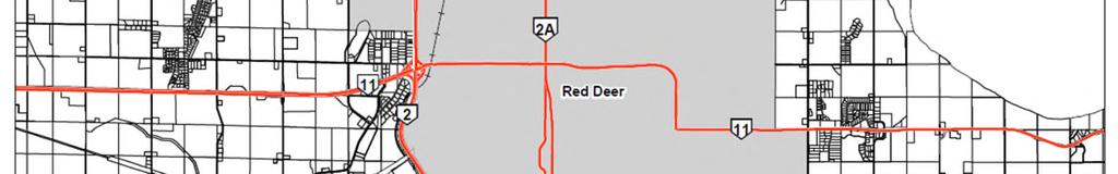
5 1.0 Introduction 1.1 Background The Central Park Area Structure Plan, which was originally adopted in 1996, was undertaken in a response to development pressures within the Central Park area at that time. Since then a number of changes have occurred including the annexation of a major portion of the plan area into the City of Red Deer, as well as the adoption of the current Municipal Development Plan (MDP) and the Red Deer County & City of Red Deer Intermunicipal Development Plan (IDP). As a result, the Central Park ASP requires a number of revisions in order to address these and other changes. Given that the plan area is comprised of approximately 16 quarter sections, it is also technically considered a Major Area Structure Plan according to the criteria included in the current MDP. Therefore, this version of the Central Park ASP will be referred to and adopted as the Central Park Major Area Structure Plan (MASP). 1.2 Purpose The purpose of the MASP is to provide a planning policy framework for the development of various land uses (i.e. country residential) within the Plan area and sets out conditions under which such developments may be considered. 1.3 Location The Central Park MASP is located immediately north of the City of Red Deer and is bounded to the north by the Blindman River, and to the east and west by two major provincial highways, Highway 2A and Highway 2 respectively (refer to Figure 1.0). 1.4 Planning Process The original plan was developed in consideration of a vast amount of detailed information that was gathered during an extensive background research and public input process. Initially, all relevant background information involving the plan area was gathered and analyzed. Various public agencies were also contacted in order to help identify and provide comments on all natural and manmade features within and surrounding the area which may either affect, or be affected by, any form of future development in the MASP area. The original plan process also involved a public input process wherein area residents and landowners were asked to complete an area wide mail out survey and to attend a public information session. For further information regarding the public input process used during the development initial MASP please refer to Appendix A. 4 P a g e
6 The development of the revised Central Park MASP involved a similar process whereby all the supporting background information was reviewed and analyzed in order to determine the various required changes. The policy section was also reviewed and amended in order to ensure alignment with the latest County plans as well as the City/ County IDP. Additional public input was not sought during the review process given that the intent was to simply reformat and update the document. In addition, no major changes to the Plan s land use concept in particular can occur given that the policies included in the IDP essentially prohibit changes to all approved ASPs within the City of Red Deer s growth area with the exception of changes required to ensure alignment with higher level planning documents (i.e. MDP and IDP) and changes to municipal boundaries. 2.0 Site Context The Central Park MASP area encompasses some six square kilometres comprising approximately 16 quarter sections of land, both whole and those fragmented by natural and manmade features. This Section summarizes the existing conditions of the area which are significant for identifying opportunities and constraints to future land use, and formulating appropriate ASP policies. 2.1 Natural Features The Red Deer County Environmentally Significant Areas Inventory, prepared in 2011, identifies one area within the Central Park MASP area as a regionally significant Environmentally Sensitive Area (see Figure 2.0) which is recommended to be preserved and protected to the greatest extent possible. The bank of the Blindman River has been identified as a key deer habitat and home to a great blue heron colony. The river lands are terraced with slumping banks in some areas. The Crown claims ownership of the bed and shores of the Blindman River. Other wetland areas and existing tree stands are identified on Figure 2.0. One area located in the N 1/2 of Section , is a large Crown owned slough area which is also covered with trees and brush. The land around the slough is flat, open and presently being farmed. Several other small sloughs and treed patches are also located throughout the Central Park MASP area. Most of the Central Park MASP area is best described as flat to gently rolling farmland. However, the central portion rises slightly toward a moderate ridge running in an east/west direction. The west portion located adjacent to Highway 2 towards Highway 11A, is generally low and flat. The highest point in the Plan area is located in the northwest corner, near the point where Highway 2 crosses the Blindman River. This tree covered area slopes steeply towards the river and the southeast and would likely be difficult to develop. The lands located adjacent to the Blindman River are terraced towards the River with slumping, treed banks in some areas. Several small ravines run intermittently down these terraced slopes. These ravines are used effectively by the Spruce Lane Acres Subdivision as natural borders and features. The area along the River 5 P a g e
7 has high ground water and a shallow soil layer; several of the homes in this area do not include sub-surface basements because of this development constraint. One of most significant natural resources located within the plan area are its gravel deposits, particularly those located along the Blindman River. Provincial and municipal policies generally support the removal of natural resources. However, the draft provincial land use policies, in considering resource development, also support mitigating environmental damage and any negative impacts on surrounding areas and land uses. A non-active gravel pit is located adjacent to Highway 2 in the SW Also, an old borrow pit has been identified just south of the gravel pit along Highway 2 in the SE Existing Land Use and Points of Interest Most of the Central Park MASP area is used for agricultural purposes with some scattered country residential and other forms of development mixed into the landscape. The land use pattern is reflected by the land use districting (zoning) as determined by the Land Use Bylaw. Existing zoning patterns are shown on Figure 3.0. The majority of the plan area is zoned as Agriculture. Non-agricultural uses are as follows: Country Residential There are a total of four country residential subdivisions located within the Central Park MASP plan area. Louis Victor subdivision is comprised of five large developed lots. The site is located in the NE , along the low plateau of the Blindman River. The area is quite heavily treed and backs onto the slope to the Blindman River, providing these lots with a high degree of privacy. Spruce Lane Acres subdivision has a total of 36 lots which was developed within three phases. This development is located on top of the slopes leading to the Blindman River in the SW Once again, the area is quite heavily treed thereby providing a good degree of privacy to each lot. Valley Ridge subdivision was registered in 2005 and consists of 44 country residential lots located directly east of the Spruce Lane Acres subdivision. Lastly, Wolf River Estates subdivision was registered in 2011 and includes 11 country residential parcels, one environmental reserve and one public utility lot. This subdivision is located within the NW Public Service Lands A number of public service lands are located throughout country residential subdivisions. These lands are intended to allow for uses and facilities used by the public including park space Post Mill Plant An abandoned post mill plant site, located in the SE , still contains some remnant buildings and a collection of old vehicles and trailers, as well as an occupied residence. This site is in close proximity to several homes and, therefore, may not be suitable for future industrial uses. The site also has been 6 P a g e
8 contaminated. The west half of the lot is owned by Alberta Transportation and Utilities, and contained the main area of contamination. However, this area has subsequently been excavated and the contamination has been removed from the site. The remainder of the parcel has localized areas of contamination, according to Alberta Environmental Protection, and until remedial work is completed on the remainder of the property, there is a potential human health hazard originating in the groundwater, dermal contact with the soil and the ingestion of beef or dairy produce Picnic Grounds An abandoned picnic ground is located in the very northeast corner of the Central Park MASP plan area, where Highway 2A and the Blindman River meet. Owned by Alberta Transportation and Utilities, it is no longer being maintained and all facilities have been removed. The property is used as an access for fishing in the River. The approach into this property was recently upgraded as part of the upgrade of the Blindman River Bridge. However, the approach was intended to provide access to an abandoned wellsite. Alberta Transportation has indicated that because of poor site lines and distances, the Department would oppose the use of the approach to accommodate any further traffic Farmsteads Numerous farmsteads and residences are scattered throughout the Plan area. Of particular note are the lots located along the C & E Trail. This feeder route runs through the center of Central Park in a north/south direction and provides direct access to a number of larger country residential sites and hobby farms. There are also several homes in the area of the old post mill site near Highway 2A, and in the area of fragmented land adjacent to Highway 2, south of an old feed lot. 2.3 Agricultural Capability The preservation of good quality agricultural land was considered the most important priority for the landowners and residents of the Central Park MASP area. This is also a high priority for the County in general and is supported by the Red Deer County Municipal Development Plan. Excepting some marginal low-lying and steeply sloping areas, virtually all of the plan area is rated as relatively good quality agricultural land by the County's Assessment Department. Red Deer County s Assessment Department applies a rating system for agricultural capability. Lands rated 28% or higher are considered good quality for assessment purposes. Most of the Central Park MASP area is rated 50% or higher. Most areas rated higher than 50% are currently in agricultural production. The areas rated 28% to 50% are generally poorly drained, or contain slopes or hills that make farming difficult. Areas rated less than 28% are generally wetlands covered with brush and trees, the largest of which is located in the northwest corner of the Central Park 7 P a g e
9 ASP area. These lands are characterized by steep slopes and tree stands, particularly along the Blindman River. Some of the areas rated high in terms of agricultural capability are fragmented and, therefore, difficult to farm. This applies particularly to the northeast corner of the Central Park MASP area which has been fragmented by the road system and the CP line. In terms of preserving good quality agricultural lands, these fragmented areas are of less value than the extensive unfragmented agricultural areas. 2.4 Existing Transportation Features The Central Park MASP area's existing transportation system is illustrated by Figure 4.0. Two provincial highways bound the plan area, which provides limited access to the Central Park Plan area. Highway 2 bounds the west portion of the Plan area. Presently Highway 2 is a 4 lane divided major highway, which has a right out only entrance point from Township Road 392. Highway 2A bounds the plan area to the east, which includes multiple access points along Range Road 272 and Township Road 392. Highway 2A is a two lane undivided highway and has undergone realignment and intersection improvements since the development of the original Central Park ASP. Both Highway 2 and 2A provide access across the Blindman River. Collector roads in the Central Park plan area include one east-west road, Township Road 392. In regards to north-south collector roads, the C&E Trail is the main collector road which connects to Taylor Drive at Highway 11 within the City of Red Deer. At one time C&E Trail connected to a bridge crossing of the Blindman River, but this has since been closed. Local roads found throughout the plan area mainly stem from C&E Trail and provide access to country residential subdivisions. Two railway lines traverse the Central Park MASP area. The CN mainline runs diagonally through the area in a southwest to northeast direction, generally paralleling Highway 2A. In the northern portion of the Central Park MASP area, the CP railway diverts to the northwest to cross the Blindman River. 2.5 Future Transportation Features In terms of future transportation features in and around the Central Park MASP area, further limitations on accessing the highway system can be expected. Alberta Transportation will be eliminating all direct accesses on to Highway 2, north of Highway 11A. Therefore, the current access onto Highway 2 from Township Road 392 will be closed at some point in the future. Full freeway standards, which plan to six-and-eight lane Highway 2, will restrict any access to Highway 2 to interchange locations. No further interchanges are planned within the Plan area. The potential closure of the north access onto Highway 2 from Township 392 restricts more intensive development in the area. As such, the area should continue to be 8 P a g e
10 designated for low density agricultural use to reduce the need for the Highway 2 access. Access to the north is also restricted due to the closure of the bridge on the C & E Trail across the Blindman River. Alberta Transportation also intends to limit any additional approaches onto Highway 2A in the future. Highway 2A is currently undergoing preliminary plans for twinning and has identified the intersection of Range Road 272 and Highway 2A as a potential intersection closure. This closure would greatly impact Central Park residents as the only remaining access would be via C&E Trail (Taylor Drive). Coordination with the City of Red Deer and Alberta Transportation is required to connect transportation networks within the Central Park MASP and the City s North of Highway 11A MASP. Regarding future local road patterns, roadway designs will be contemplated at a Local Area Structure Plan level should a developer come forward to develop further country residential subdivisions as identified within the Future Land Use Concept. 2.6 Utilities Major Utility Facilities Alberta Energy Regulator (AER) has identified several pipelines and abandoned well sites within the Central Park MASP plan area (as seen in Figure 5.0). None of the pipelines identified were of concern in terms of future development, and any application for subdivision must refer to the AER to ensure development will not conflict with any energy and utility infrastructure facilities Water and Sanitary Sewage Most residences in the Central Park MASP area are served by on-site water and private sewage treatment and disposal systems. Only the Central Park country residential subdivision, which is no longer located within the plan area, has its own communal water system. No major concerns regarding water supply and existing sewer systems have been identified Storm Water Management Figure 6.0 shows a low ridge of land running west to east which divides the Central Park MASP area into two watersheds. The southwest corner of the plan area drains to the Red Deer River. The majority of remaining lands north of the ridge feed the Blindman River. The north catchment area discharging to the Blindman River utilizes well defined overland drainage courses, railway and roadside ditches. With the exception of one or two small sloughs, significant areas of ponding are not apparent. In accordance with the provisions of the Alberta Environmental Protection and Enhancement Act (AEPEA), all drainage diversions, infilling of wetlands, and the deliberate ponding of water are subject to approval and licensing by Alberta Environmental Protection and the Water Resources Act. Where infilling is occurring 9 P a g e
11 for development purposes, it is important that the County ensure that the filled lands are capable of supporting physical development before issuing any permits. 3.0 Policy Context 3.1 The Municipal Government Act The Municipal Government Act is the legislative framework in which all municipalities operate under within Alberta. Section 633 of The Municipal Government Act, outlines the purpose and the content of an Area Structure Plan as stated in the following subsections: (1) For the purpose of providing a framework for subsequent subdivision and development of an area of land, a council may by bylaw adopt an area structure plan. (2) An area structure plan (a) must describe i. The sequence of development proposed for the area ii. The land uses proposed for the area iii. The density of population proposed for the area either generally or with respect to specific parts of the area, and iv. The general location of major transportation routes and public utilities and (b) may contain any other matters the council considers necessary. 3.2 Red Deer County Municipal Development Plan The Municipal Development Plan (MDP) is the primary planning policy document for Red Deer County. It is intended to provide a broad land use planning framework for the future growth and development of all lands within the County. The MDP has been prepared in accordance with Section 632 of the Municipal Government Act. Its policies align with Provincial Legislation and will be implemented through the Land Use Bylaw to assist Council, approving authorities, and the Subdivision and Development Appeal Board in making land use decisions that reflect the collective vision for Red Deer County in the future. Specifically agriculture and multi-lot country residential subdivisions are the primary land uses located within the Central Park Major Area Structure Plan. Red Deer County s MDP identifies agriculture as the primary industry and mainstay of its history, rural character, and culture. The protection of agricultural operations and minimizing the conversion of agricultural lands to non-agricultural uses is a priority. At the time when the Central Park MASP was originally developed traditional style country residential subdivisions were being considered and approved. However, since that time it has become apparent to the general public that this form of development is not sustainable on a variety of levels. Traditional country residential subdivisions require larger lots and 10 P a g e
12 therefore consume agricultural land. They are also typically serviced by private on-site water and septic systems which in some cases have led to issues involving decreased or lack of ground water supply as well as surface water and ground water contamination from failing private sewage systems. As a result, the County s approach to country residential development has evolved which is reflected in the policy direction provided by the current MDP. Country residential development may still be considered but under special circumstances and must be designed in accordance with Country Residential Conservation Subdivisions principles. In general the MDP directs country residential development to growth Hamlets which are serviced by municipal water and waste water systems. A situation where it may be considered outside of a growth hamlet would be in an area in which an area structure plan was adopted prior to the current MDP and IDP that identifies areas suitable for traditional country residential development. 3.3 Intermunicipal Development Plan Red Deer County & City of Red Deer Intermunicipal Development Plan is based upon a shared vision of a future growth framework and reflects the mutual agreement on Growth Areas for each municipality. This Plan provides policy direction for the preservation of Natural Capital, areas of common land use planning interest, long range planning, infrastructure and services provision (including opportunities for cooperation), and Annexation Areas for The City. The Plan further provides for the Intermunicipal review of all area structure plan, concept plan and outline plan proposals or amendments and redesignation, subdivision and development permit applications within The City of Red Deer Growth Area prior to annexation and within the Collaborative Planning Area and the Agricultural or Open Space Area until further amendments to this plan. This Plan also provides policy direction for the resolution of disagreements and for plan implementation and administration. The Central Park Area Structure Plan area is located within the City of Red Deer s Growth Area as indicated in the IDP. In general the IDP does not allow for the creation of new Area Structure Plans to be approved within the City Growth Area, however, the Central Park MASP was originally approved prior to the adoption of the Intermunicipal Development Plan. Until such time as the IDP is amended, Policy (2), which reads as follows, is in effect: Effective from the date of the adoption of this Intermunicipal Development Plan (July 5, 2007) until more detailed policies are adopted as part of this Plan to provide the appropriate policy guidance existing area structure plans shall be implemented and existing concept plans and outline plans shall be considered. Unless otherwise agreed to by The County and The City, consideration of the following types of applications shall be deferred until more detailed policies are adopted as part of this Plan to provide the appropriate policy guidance: a) additional area structure plans, concept plans or outline plans, except those outline plans that are required to implement existing area structure plans; 11 P a g e
13 b) redesignation applications that are inconsistent with existing area structure plans; and c) amendments to existing area structure plans, concept plans or outline plans. IDP Policy (5), however, allows amendments to be made to existing ASP s to ensure conformance with Provincial Legislation, the IDP and the County MDP subject to review as per the IDP. It is also important to note that if there is any inconsistency with the policies of the MASP and the IDP the policies of the IDP will prevail. 3.4 Area Structure Plans Red Deer County s Municipal Development Plan requires a Local or Major Area Structure Plan (ASP) to be prepared in accordance with Section 633 of the Municipal Government Act. As mentioned previously, given the size of the plan area, which spans multiple quarter sections, the Central Park ASP is considered a major ASP. There are currently no local area structure plans within the plan area. 3.5 Area Concept Plans One concept plan is located within the Central Park Major Area Structure Plan, Wolf River Estates Area Concept Plan. This non-statutory Concept Plan was developed to provide a framework for the subdivision and development of part of the NW that is located in the northern portion of the Central Park Major Area Structure Plan, south of the Blindman River. The land comprises approximately 12 hectares (30.4 acres) and was developed as a low density residential neighbourhood. In total the Concept Plan intended to create 11 country residential parcels with a minimum lot size of 2 acres, one environmental reserve and one public utility lot. 3.6 Land Use Bylaw The purpose for Red Deer County s Land Use Bylaw is to regulate the use and development of land and buildings throughout the County, pursuant to Part 17 of the Municipal Government Act. Central Park is comprised of a mix of Agricultural District (AG), Country Residential District (R-1), and Public Service District (PS) land uses. No person is permitted to conduct any development within the County without complete compliance with the Land Use Bylaw. 4.0 Future Land Use Concept The revised Future Land Use Concept is based primarily on the direction provided by the original Central Park MASP and the land use pattern that has developed in the area since 1996 (see Figure 7.0). The revised Future Land Use Concept recognizes and removes the area that has been annexed by the City of Red Deer. It does not propose any additional development areas other than those areas that were originally contemplated. The land use categories and the 12 P a g e
14 policies associated with them have, however, been slightly modified to reflect the current Municipal Development Plan policy direction and the current Land Use Bylaw. The following is a brief description of each of the land use categories in the context of the overall revised land use concept. Agricultural The majority of the Plan area is designated Agricultural in recognition of the existing agricultural operations occurring in this area. The intent of this area is to allow for agricultural uses to occur on largely unfragmented parcels which includes those located south of Range Road 392, and the northwest segment of the plan area. This land use area also includes the poorer quality wet lands located in the south portion of the Central Park plan area, in order to protect the natural drainage course by maintaining existing agricultural runoff rates and thereby avoiding future flooding. Country Residential Additional country residential development in the Central Park MASP area is restricted to marginal or fragmented lands closer to the Blindman River, as can be seen in Figure 7.0. The existing land use pattern and agricultural capability ratings support directing such development to the north of the CN line, just below the escarpment of the Blindman River. CP rail is generally opposed to local crossing of its rail lines which will have an effect on the design configurations of these country residential subdivisions. Country residential areas are intended for the development of country residential acreages. 5.0 Policy Direction The following section includes policy direction for each of the individual future land use areas, existing land uses, municipal infrastructure, parks and open space, and transportation. General Objectives 1. To preserve high quality agricultural lands for agricultural purposes. 2. To direct future country residential development towards the fragmented lands near the Blindman River, in the vicinity of existing such development. 3. To protect significant environmental features in their natural state. 4. To consider improvements to the internal circulation system while still recognizing the limitations of the system in proposing additional development. 5. To protect for a safe, efficient and cost-effective primary highway system in accordance with Alberta Transportation and Utilities' long term plans. 13 P a g e
15 6. To avoid any future drainage problems in the vicinity of the natural drainage courses and low lying areas which form an integral part of these courses by directing development away from these areas. 7. To provide unencumbered opportunities for the future urban expansion of the City of Red Deer north into the Central Park MASP area. The policies listed below are unique to the Central Park MASP area and are to be applied at the time of new subdivision and development. All existing statutory plans and policies, particularly those policies contained in the County s Municipal Development Plan, must also be applied. 5.1 General Policies The following policies apply to the entire Central Park MASP area All future subdivision and development within the Plan area shall comply with the Land Use Concept as shown on Figure A historical review of any lands proposed to be developed must be performed, as per the Historical Resources Act, prior to any land disturbance in order to identify any possible historic resource concerns Builders and business owners shall be encouraged to design, locate and construct buildings with the objective of reducing resource and energy consumption The County shall promote compatible infill development of undeveloped lands within the plan area, excluding the area designated Agriculture The County shall refer future development proposals, intersection improvement proposals, and Local Area Structure Plans to Alberta Transportation in order to confirm building setbacks from major roadways. Setbacks will be enforced at the Roadside Development Permit stage Prior to the approval of any subdivision a stormwater management plan, prepared by a qualified professional engineer, must be provided and approved for the subdivision area Figure 2.0 identifies areas that due to the existing significant natural features (i.e. significant tree stands, heavy vegetation, etc.) should be maintained in their natural state wherever possible. The conservation of these areas should be considered at the time of development Off-site levy charges shall apply to all new development within areas identified in the off-site Levy and Transportation Contribution Bylaw 2011/10 as amended from time to time. 14 P a g e
16 5.1.9 The County shall refer all proposed developments adjacent to a railway right-of-way to the corresponding railway company. 5.2 Agriculture Goal: To conserve agricultural lands and allow agriculture to thrive within the County. Objective: To promote agriculture and conserve agricultural land wherever possible within the Central Park MASP area. Policies: The development of lands designated Agriculture, excluding first parcel subdivisions, shall not be supported within the Plan area No new confined feeding operations (CFO s) shall be developed within the Central Park Major Area Structure Plan boundaries. 5.3 Country Residential Goal: To allow for opportunities for people to live in a rural setting and enjoy a rural lifestyle while ensuring multi-lot country residential development occurs in an orderly and environmentally safe manner. Objective: To allow country residential development to occur in appropriate locations within the Central Park MASP area. Policies: Multi-lot country residential development shall be permitted only within those areas identified in the Future Land Use Concept plan All multi-lot country residential developments shall require the adoption of a Local Area Structure Plan in accordance with the Implementation Policies of this plan, the Municipal Development Plan, and the Red Deer County & City of Red Deer IDP To ensure that undue strain is not placed on the existing transportation system, that new development is compatible with existing development, and that the integrity of the environment and natural features are maintained, the minimum country residential lot size shall be in accordance with regulations identified in Red Deer County s Land Use Bylaw Existing natural features, including mature tree stands, shall be preserved wherever possible by integrating these features into the design of new subdivisions. 15 P a g e
17 5.3.5 Appropriate buffer strips, as determined Local Area Structure Plans required under Policy 5.3.2, shall be provided where country residential uses back onto major transportation features, including highways and rail lines. These buffer strips shall allow for both noise abatement devices and/or visual screening, and shall be designated as public utility lots Municipal reserve lands may be provided where it can be demonstrated in a Local Area Structure Plan, as defined by Policy 5.3.2, that the lands are developable as park/ open space and will serve that function. This includes using municipal reserve to preserve attractive, mature tree stands, as long as the lands are relatively flat and well drained. Strips of land used as buffers from major transportation features may be designated municipal reserve only if the strip is intended to form part of an integrated trail system Where the need for municipal reserve lands cannot be demonstrated, cash-in-lieu or deferral of municipal reserve lands may be provided Where slopes exceed 15 percent, the Development Officer shall require that a geotechnical study be prepared by a qualified engineer certifying the stability of the slope and its safety for the proposed development or identifying required remedial measures Any subdivision proposals backing onto the Blindman River must clearly identify the top-of-the-bank contour. To ensure that the River is preserved as an environmentally significant natural feature both the lands below the top-of-the-bank and a 30 metre setback from the top-of-the-bank to a property line shall be dedicated as Environmental Reserve All subdivision applications must precisely identify the 1:100 year flood plain. No permanent structures shall be permitted within the flood plain All subdivision applications for lands located between the 1:100 year flood plain level and the River valley escarpment, as shown on the Future Land Use map, shall identify appropriate footing elevations based upon the level of the groundwater table Lands which are deemed to be undevelopable based on groundwater and soils conditions shall remain either in their natural state or be used for agriculture All proposed residential developments adjacent to a railway shall: a) consider the effects of the noise and vibration generated by rail activities, and minimize these effects to the greatest extent practicable; and b) developers may be required to submit a technical assessment to the County upon request, prepared by a professional, and implement mitigative measures as recommended and approved. c) Any cost associated with mitigating noise and vibration impacts from railway traffic shall be borne by the developer. 16 P a g e
18 5.4 Parks & Open Space Goal: To allow for the development of parks and preservation of natural areas and open spaces. Objective: To conserve significant natural areas/amenities such as wetlands, riparian areas and significant tree stands; to secure lands for parks and trails; to provide access to natural areas and amenities. Policies: Developers shall be encouraged to maintain the integrity of natural features within individual lots wherever possible. Municipal Reserves Municipal Reserve and/or Environmental Reserve dedications will be addressed at the time of subdivision in accordance with Part 17 of the Municipal Government Act (MGA) and the Red Deer County & City of Red Deer Intermunicipal Development Plan All Municipal Reserve dedications shall be provided in the form of land or deferred as directed by the City of Red Deer in accordance with the Red Deer County & City of Red Deer IDP. Environmental Reserves Environmental Reserves will be considered particularly in areas that abut the bed and shore of any lake, river, stream; Red Deer County may require the owner if a parcel of land that is the subject of a proposed subdivision to provide part of that parcel of land as environmental reserve subject to section 644 of the Municipal Government Act. 5.5 Transportation Goal: To create a transportation network that is efficient, effective and safe for all modes of transportation. Objective: To allow for the development of a safe, efficient and cost effective transportation network which is integrated with existing land use patterns and supports future development. Policies: All internal collector roads shall be constructed in accordance with Red Deer County road standards at the expense of the developer. 17 P a g e
19 5.5.2 Future road widening to any existing roads shall be dedicated at the time of subdivision Access roads for all new multi-lot country residential subdivisions must adhere to, and shall be paved in accordance with the County s Municipal Development plan Internal roads within multi-lot residential subdivisions shall be paved and constructed in accordance with County road standards Access to parcels within multi-lot country residential development shall be from internal roads rather than direct access to a highway or a County road Any required upgrades to existing roadways, as a result of a proposed development, shall be undertaken at the expense of the developer with the exception of road improvements funded by off-site levies All new roads shall be designated to minimize impacts on any ecologically sensitive areas (i.e. creeks, tree stands, and wildlife) Emergency accesses, to an egress from development sites must be identified in all Local Area Structure plans prepared by the developer A Traffic Impact Assessment (TIA) may be required in consideration of a Local Area Structure Plan and/or as a condition of subdivision in order to determine if improvements to the existing road network are required The County shall require a transportation contribution from all benefiting developers to be provided at the time of subdivision, development or redevelopment to pay for road upgrades within the plan area as per the Off-Site Levy and Transportation Contribution Bylaw No. 2001/10 as amended from time to time In evaluating the transportation access components of local area structure plans prepared for Country Residential uses, rail crossings should be considered only if no alternate means of access is available, if the affected rail company supports the crossings, and if the crossings are constructed to a high standard No new additional highway accesses or intersections shall be allowed onto Highway 2 and 2A within the plan area Any proposed road networks must be referred to Alberta Transportation and the City of Red Deer for review. 5.6 Franchise Utilities Goal: To ensure landowners are adequately services by franchise utility services such as electricity, gas and telecommunication networks. 18 P a g e
20 Objective: To ensure adequate right of ways are provided for franchise utilities and to ensure all new lots are adequately serviced by shallow/franchise utilities. Policies: New subdivisions and developments must be fully serviced which includes shallow/franchise utilities (i.e. natural gas, electrical, telecommunications) Utility alignments will be identified at the Local Area Structure Plan stage Development will proceed in a logical sequential manner to ensure availability of utilities Utility rights-of-way will be incorporated into development sites and protected easement Easements to protect utility rights-of-way will be required as a condition of subdivision approval for the affected lands Utility rights-of-way not already owned by the operator will be dedicated as public utility lots Public utility lots to accommodate major utility rights-of-way will be required as a condition of subdivision approval All shallow/franchise utilities are to be extended into the Plan area by the individual applicants as required and shall be a condition of subdivision approval Developers may be required to provide, or enter into an agreement to provide utility rights-of-way or easements necessary to accommodate the extension of municipal utilities in advance of development to allow for the servicing of an adjacent site Existing utility infrastructure (i.e. fibre optic telecommunication cable, underground electrical and gas lines) shall be protected when considering subdivision and development proposals adjacent or in proximity to these features. 5.7 Water and Sanitary Services Goal: To ensure residents and businesses have access to safe water and are not negatively impacted by sewage disposal systems. Objective: To ensure developments are served adequately by water and sanitary sewer systems and to promote water conservation in order to reduce pressure on existing water sources. 19 P a g e
21 Policies: All subdivisions and development shall be serviced by: a) Connection to municipal services or regional service lines when they become available; or b) communal services in association with multi-lot condominium developments until such time as connections to municipal or regional service lines can be made; or c) individual on-site water and waste water systems may be considered for multi-lot subdivisions in accordance with the Municipal Development Plan and approved Area Structure Plan Communal water systems and sewage treatment facilities shall be developed in accordance to the standards of the appropriate Provincial regulatory agency and be licensed by the Province. 5.8 Storm Water Management Goal: To ensure surface water/storm water run-off does not negatively impact lands adjacent to each other, lands downstream of other developments or negatively impact lands outside of the Plan area. Objective: To prevent developments from being negatively impacted by storm water run-off. Policies: Stormwater management designs shall adhere to Best Management Practices in accordance with Environmental and Sustainable Resource Development and County Engineering Standards in order to ensure runoff quality Any storm water ponds required at the subdivision stage shall be designated as a Public Utility Lot (PUL) within the Public Utility District of the County s Land Use Bylaw All new developments shall provide a storm water management plan which identifies the location of all onsite storm water management containment areas as well as storm water flow rates On-site drainage and surface/storm water run-off shall not be directed into highway road rights-of-way unless approved by the Province. 5.9 Oil and Gas Infrastructure Goal: To reduce potential safety hazards associated with oil and gas infrastructure and to protect vital energy corridors. 20 P a g e
22 Objective: To mitigate potential impacts on residents and developments from existing and abandoned oil and gas infrastructure and to mitigate impacts on existing pipelines, oil and gas infrastructure and to mitigate impacts on existing pipelines, oil and gas infrastructure due to new development. Policies: All proposed developments shall comply with all Provincial requirements regarding developments setbacks from all producing and abandoned oil and gas wells as well as all pipelines All proposed Local Area Structure Plans shall identify all existing and abandoned oil and gas infrastructure as well as the proposed, detailed longer term land use pattern within the development setback area. 6.0 Implementation 6.1 Interpretation Where the words say may, should or shall are used in the Central Park Major Area Structure Plan they are also interpreted as follows: 6.2 Plan Amendments May policies indicate support in principle with the required level of compliance to be determined by the applicable authority; Should policies mean compliance in principle is required but subject to the discretion of the applicable authority; and Shall policies are mandatory and must be complied with The Municipal Government Act requires that all statutory plans adopted by a municipality must be consistent with each other. The Central Park (Major) Area Structure Plan adopted in 1996 was not consistent with the Red Deer County MDP (2012). The Central Park Major Area Structure Plan, therefore, has been updated/amended in order to conform to the Red Deer County MDP, Bylaw 2012/26. Prior to the adoption of the revised ASP the Plan must be reviewed jointly by the City and the County Administrations in accordance with IDP Section 3.7. The approval of the Central Park Major Area Structure Plan will not affect the existing Red Deer County & City of Red Deer Intermunicipal Development plan (Bylaw 2007/29). In the future, the Central Park Major ASP may require updating in order to reflect changes to the municipal boundaries or general municipal policy direction. The Plan should be reviewed in five years or soon thereafter in order to ensure consistency with the County s policies and to reflect any 21 P a g e
23 6.3 Land Use Bylaw changes that may occur to the City/County boundary due to any future annexations The Land Use Bylaw designations in effect at the time of approval of the Plan shall continue to apply in accordance with the provisions of the Municipal Government Act, and remain in effect until it is deemed appropriate to redesignate the lands in accordance with the policies of the Plan. 6.4 Local Area Structure Plans The principle means of implementing the Central Park MASP will primarily be through the adoption of more detailed Local Area Structure Plans for the areas indicated in Figure 8.0 prior to the redesignation and/or subdivision of these areas within the Plan All proposed Local Area Structure Plans must be consistent with the Central Park MASP and include all necessary information as may be required by the County. 6.5 Plan Administration and Implementation Pursuant to the provisions of Section 633(1) of the Municipal Government Act, 2000, this Area Structure Plan shall be adopted by Red Deer County as the Central Park Major Area Structure Plan. All subdivision and development within the Central Park MASP area shall be in accordance with the provisions and policies of this plan The Appendices are not subject to the Major Area Structure Plan amendment process and do not form part of the Bylaw Consistency between this Major Area Structure Plan, other Council-approved policy documents, and the Red Deer County & City of Red Deer Intermunicipal Development Plan must be achieved in practice The County shall require that the development of a new multi-lot subdivision with a density of two (2) or more lots per ¼ section to prepare a local area structure plan as per the County s Municipal Development Plan. Such plans shall also comply with the policies of this Major Area Structure Plan and include all necessary information as may be required by the County for processing, such as a proposed land use concept, detailed information pertaining to servicing, infrastructure, landscaping, stormwater management, etc. Local Area Structure Plans must adhere to applicable Federal and Provincial regulations, as well as municipal bylaws and statutory plans (i.e. Land Use Bylaw and Municipal Development Plan). The County shall ensure that every development proposal meets the intent of the Central Park Major Area Structure Plan. 22 P a g e
24 6.5.5 Specific land use designations shall be determined at the time of a Local Area Structure Plan preparation. Each land use designation must be consistent with the Land Use Bylaw Deferred servicing agreements shall be registered on the land titles of all new subdivided lots within the Plan area in accordance with the Red Deer County & City of Red Deer Intermunicipal Development Plan. 6.6 Plan Amendments 6.7 Phasing Provided that the intent of the Central Park MASP is adhered to, minor adjustments to the boundaries of various land uses may be made without an amendment to the Plan. Any major changes to this Plan; however, will require an amendment in accordance with the Municipal Government Act Where an amendment to the Major Area Structure Plan is requested, the applicant will be required to submit the supporting information necessary to evaluate the amendment to the satisfaction of the County The County shall ensure that appropriate stakeholders and the general public are provided with the opportunity to provide input into all future amendments to the Plan Phasing will occur in a manner that addresses the logical extension of roads and existing services. Each phase of development shall not prejudice the further subdivision and development of any subsequent phases of the development or development of surrounding lands. 23 P a g e


25 24 P a g e
26 25 P a g e
27 26 P a g e
28 27 P a g e

29 28 P a g e
30 29 P a g e
31 30 P a g e
32 31 P a g e


33 Appendix A Past Public Input 32 P a g e

34 33 P a g e

35 34 P a g e
WEST HILL BUSINESS PARK AREA STRUCTURE PLAN
 MUNICIPAL DISTRICT OF PEACE NO. 135 WEST HILL BUSINESS PARK AREA STRUCTURE PLAN Prepared by: TABLE OF CONTENTS 1.0 Introduction... 1 1.1 Purpose of Plan........ 1 1.2 Plan Area..... 1 1.3 Existing Conditions...
OP Council Resolution June 16, Planning and Development Services
 OP-08-01 Council Resolution June 16, 2008 Planning and Development Services Kingsgate Landing Outline Plan Table of Contents 1.0 Introduction 1 1.1 Purpose of Plan 1 1.2 Plan Area Location 1 1.3 Ownership
City of Grande Prairie Development Services Department
 City of Grande Prairie Development Services Department ROYAL OAKS NORTH OUTLINE PLAN OP-07-03 NW 35-71-6 W6M May 7, 2007 Royal Oaks North Outline Plan TABLE OF CONTENTS 1.0 INTRODUCTION........ 3 1.1 Purpose
Leduc Industrial Outline Plan SE W4
 Leduc Industrial Outline Plan SE 1-50-25-W4 Within the North Leduc Industrial ASP Prepared for: Leduc Energy Park Ltd. Prepared by: Stantec Consulting Ltd. File No. 1161 104655 V5 Table of Contents 1.0
City of Grande Prairie Development Services Department KENNEDY DEVELOPMENTS LTD. OUTLINE PLAN OP-09-01
 City of Grande Prairie Development Services Department KENNEDY DEVELOPMENTS LTD. OUTLINE PLAN OP-09-01 July 27, 2009 TABLE OF CONTENTS 1.0 Introduction... 1 1.1 Plan Area Location & Context... 1 1.2 Ownership
S o u t h C e n t r a l O u t l i n e P l a n. Leduc Business Park. North Leduc Industrial Area Structure Plan C it y of Led u c.
 Leduc Business Park North Leduc Industrial Area Structure Plan C it y of Led u c Prepared for Farm Air Properties Inc. January, 2007 Table of Contents Page Number 1.0 Purpose of Plan and Definition of
LAND USE AMENDMENT CORNERSTONE (WARD 3) 60 STREET NE AND COUNTRY HILLS BOULEVARD NE MAP 26NE BYLAW 22D2017
 60 STREET NE AND COUNTRY HILLS BOULEVARD NE MAP 26NE BYLAW 22D2017") Page 1 of 14 EXECUTIVE SUMMARY This Land Use Amendment application covers an area of 43.76 hectares ± (108.14 acres ±) located in northeast Calgary, bound by Country Hills Boulevard NE to the south and
Page 1 of 14 EXECUTIVE SUMMARY This Land Use Amendment application covers an area of 43.76 hectares ± (108.14 acres ±) located in northeast Calgary, bound by Country Hills Boulevard NE to the south and
ROAD CLOSURE AND LAND USE AMENDMENT SILVER SPRINGS (WARD 1) NORTHEAST OF NOSEHILL DRIVE NW AND SILVER SPRINGS ROAD NW BYLAWS 2C2018 AND 29D2018
 NORTHEAST OF NOSEHILL DRIVE NW AND SILVER SPRINGS ROAD NW BYLAWS 2C2018 AND 29D2018") Page 1 of 19 EXECUTIVE SUMMARY This application proposes redesignating two parcels in the community of Silver Springs from Special Purpose Future Urban Development (S-FUD) District and undesignated road
Page 1 of 19 EXECUTIVE SUMMARY This application proposes redesignating two parcels in the community of Silver Springs from Special Purpose Future Urban Development (S-FUD) District and undesignated road
Red Fox Commercial Outline Plan
 Red Fox Commercial Outline Plan City of Cold Lake, Alberta Prepared by Durrance Projects Ltd and Ross W. Sharp & Associates Ltd October 2014 Rupert 1 Table of Contents 1. PURPOSE...3 1.1. Location...4
Bylaw C-1186 Adopted November 5, Planning and Development Services
 Bylaw C-1186 Adopted November 5, 2007 Planning and Development Services CITY OF GRANDE PRAIRIE OFFICE CONSOLIDATION BYLAW C-1186 A Bylaw to adopt the Westgate Area Structure Plan (As Amended by Bylaw C-1186-1,
C ity of Grande Prairie Development Services Department
 C ity of Grande Prairie Development Services Department FAIRWAY DEVELOPMENT OUTLINE PLAN OP 08 09 Approved April 6, 2009 Prepared by: Focus Corporation Table of Contents 1.0. Introduction 2 3 1.1. Plan
LAND USE AMENDMENT CORNERSTONE (WARD 3) COUNTRY HILLS BOULEVARD AND STONEY TRAIL NE BYLAW 9D2017
 COUNTRY HILLS BOULEVARD AND STONEY TRAIL NE BYLAW 9D2017") Page 1 of 12 EXECUTIVE SUMMARY This Land Use Amendment application covers an area of 54.92 hectares ± (135.71 acres ±) located in northeast Calgary, bound by Country Hills Boulevard NE to the north and
Page 1 of 12 EXECUTIVE SUMMARY This Land Use Amendment application covers an area of 54.92 hectares ± (135.71 acres ±) located in northeast Calgary, bound by Country Hills Boulevard NE to the north and
LACOMBE COUNTY. Highway 2 Corridor. Economic Development Study. Phase 2 Land Use Strategy
 LACOMBE COUNTY Highway 2 Corridor Economic Development Study Phase 2 Land Use Strategy adopted by Lacombe County Council September 8 th, 2003 LACOMBE COUNTY Land Use Strategy Table of Contents 1. Introduction...
The Uplands Area Structure Plan. City of Cold Lake, NE & SE W4
 City of Cold Lake, NE & SE 13-63-2-W4 July 2009 1 Contents 1 Background information... 1 1.1 Foreword... 1 1.2 Purpose... 1 1.3 Plan Area and Location... 1 1.4 Ownership... 2 2 Factors Influencing Development...
ADMINISTRATION RECOMMENDATION 2016 November 03. That Calgary Planning Commission recommends APPROVAL of the proposed Land Use Amendment.
 Page 1 of 12 EXECUTIVE SUMMARY This Land Use Amendment application covers an area of 75.76 hectares ± (187.20 acres ±) located in northeast Calgary, bound by Stoney Trail NE to the north, 128 Avenue NE
ADMINISTRATION RECOMMENDATION(S) 2017 June 15. That Calgary Planning Commission recommends APPROVAL of the proposed Land Use Amendment.
 2017 June 15. That Calgary Planning Commission recommends APPROVAL of the proposed Land Use Amendment.") Page 1 of 7 EXECUTIVE SUMMARY The proposed land use amendment seeks to redesignate a Special Purpose Future Urban Development (S-FUD) District parcel in Residual Ward 3 Sub Area 3H to Industrial Outdoor
Page 1 of 7 EXECUTIVE SUMMARY The proposed land use amendment seeks to redesignate a Special Purpose Future Urban Development (S-FUD) District parcel in Residual Ward 3 Sub Area 3H to Industrial Outdoor
BYLAW NO. 3549/2015. Being a Bylaw of The City of Red Deer to provide a uniform levy of off-site costs in respect of previously undeveloped land.
 BYLAW NO. 3549/2015 Being a Bylaw of The City of Red Deer to provide a uniform levy of off-site costs in respect of previously undeveloped land. 1 WHEREAS pursuant to provisions of Section 648 of the Municipal
Municipal Development Plan. Summer Village of ROCHON SANDS. Bylaw #241-18
 Municipal Development Plan Summer Village of ROCHON SANDS Bylaw #241-18 TABLE OF CONTENTS PART ONE: BACKGROUND AND PURPOSE 3 SECTION 1: BACKGROUND 3 SECTION 2: GOALS AND POLICIES 3 PART TWO: PHYSICAL ENVIRONMENT
AREASTRUCTURE PLAN AMENDMENT COCHRANE NORTH
 AREASTRUCTURE PLAN AMENDMENT COCHRANE NORTH In order to implement the vision outlined in the Conceptual Scheme, the following three amendments to the Cochrane North ASP are proposed: 1. Allow commercial
HAMLET OF KINGMAN AREA STRUCTURE PLAN
 HAMLET OF KINGMAN AREA STRUCTURE PLAN Prepared by: Austrom Consulting Ltd. Page 1 of 19 Table of Contents TABLE OF CONTENTS... 2 1. BACKGROUND... 3 1.1 PLAN AREA... 3 1.2 PLAN PURPOSE... 3 1.3 LEGISLATIVE
SANDSTONE SPRINGS AREA STRUCTURE PLAN
 Sandstone Springs Development Corp. AREA STRUCTURE PLAN This report is prepared for the sole use of Sandstone Springs Development Corp. No representations of any kind are made by Urban Systems Ltd. or
Outline Plan in Belvedere (Ward 9) at Street SE, LOC (OP)
 at Street SE, LOC (OP)") 2018 October 04 Page 1 of 12 EXECUTIVE SUMMARY This outline plan application was submitted by B&A Planning Group on 2016 July 15, on behalf of Tristar Communities Inc. for 50.14 hectares (123.89 acres)
2018 October 04 Page 1 of 12 EXECUTIVE SUMMARY This outline plan application was submitted by B&A Planning Group on 2016 July 15, on behalf of Tristar Communities Inc. for 50.14 hectares (123.89 acres)
WINTERBURN INDUSTRIAL AREA STRUCTURE PLAN
 OCTOBER 2009 Winterburn Industrial Area Structure Plan Office Consolidation November 2012 Prepared by: Current Planning Branch Sustainable Development City of Edmonton Bylaw 15356, was adopted by Council
ADMINISTRATION RECOMMENDATION(S) 2016 November 03. That Calgary Planning Commission recommends APPROVAL of the proposed Land Use Amendment.
 2016 November 03. That Calgary Planning Commission recommends APPROVAL of the proposed Land Use Amendment.") Page 1 of 7 EXECUTIVE SUMMARY This Land Use Amendment application seeks to redesignate a portion of the parcel from Industrial General (I-G) District to Special Purpose City and Regional Infrastructure
Page 1 of 7 EXECUTIVE SUMMARY This Land Use Amendment application seeks to redesignate a portion of the parcel from Industrial General (I-G) District to Special Purpose City and Regional Infrastructure
City of Spruce Grove East Campsite Business Park Area Structure Plan
 City of Spruce Grove East Campsite Business Park Area Structure Plan Prepared by: UMA Engineering Ltd. 17007 107 Avenue Edmonton, AB T5S 1G3 T 780.486.7000 F 780.486.7070 www.uma.aecom.com Job No. 1560
Land Use Amendment in Southwood (Ward 11) at and Elbow Drive SW, LOC
 at and Elbow Drive SW, LOC") 2018 November 15 Page 1 of 10 EXECUTIVE SUMMARY This land use amendment application was submitted by Rick Balbi Architect on 2017 August 31 on behalf of Sable Developments Ltd, and with authorization from
2018 November 15 Page 1 of 10 EXECUTIVE SUMMARY This land use amendment application was submitted by Rick Balbi Architect on 2017 August 31 on behalf of Sable Developments Ltd, and with authorization from
Palisades Outline Plan
 NE ¼ 25 36 28 W4 Town of Penhold Approved August 13, 2012 Contents Figures & Tables... 2 Introduction... 1 Overview... 1 Purpose... 1 Development Area... 3 Ownership... 3 Topography... 3 Existing & Surrounding
SUMMER VILLAGE OF SUNRISE BEACH
 SUMMER VILLAGE OF SUNRISE BEACH Municipal Development Plan Bylaw No. 132-13 ~ 2 ~ Summer Village of Sunrise Beach Municipal Development Plan 1 INTRODUCTION 1.1 SETTING The Summer Village of Sunrise Beach
11. BALLANTRAE-MUSSELMAN LAKE AND ENVIRONS SECONDARY PLAN
 11. BALLANTRAE-MUSSELMAN LAKE AND ENVIRONS SECONDARY PLAN 11.1 PURPOSE The Ballantrae-Musselman Lake and Environs Secondary Plan Area includes two small existing settlement areas, Ballantrae and Musselman
TOWN OF BRUDERHEIM Report to the capital region board
 TOWN OF BRUDERHEIM Report to the capital region board Introduction to the Town of Bruderheim Municipal Development Plan amendment and Relation to the CRB Evaluation Criteria 02 march 2017 1 Introduction
NORTHEAST RIVER CROSSING FUNCTIONAL PLANNING STUDY
 WELCOME Northeast River Crossing Functional Planning Study Phase 2 Public Meeting 4 to 8 PM Informal drop-in format and discussion tables Meeting Purpose Introduce the Northeast River Crossing Functional
Bylaw C-1262 Adopted February 6, Planning and Development Department
 Bylaw C-1262 Adopted February 6, 2012 Planning and Development Department CITY OF GRANDE PRAIRIE BYLAW C-1262 A Bylaw to adopt the Brookfield Neighbourhood Outline Plan THE MUNICIPAL COUNCIL OF THE CITY
13. VANDORF-PRESTON LAKE SECONDARY PLAN 13.1 INTRODUCTION
 13. VANDORF-PRESTON LAKE SECONDARY PLAN 13.1.1 Purpose 13.1 INTRODUCTION The Vandorf-Preston Lake Secondary Plan establishes the principles, objectives and general policies, as well as specific strategies
Poplar Ridge Area Structure Plan. Poplar Ridge. Area Structure Plan
 Poplar Ridge Area Structure Plan Bylaw 899 16 Adopted August 15, 2017 1 Contents 1 Introduction... 3 2 Background... 3 2.1 Purpose of the Plan... 3 2.2 Vision... 4 3 Description of the Plan Area... 5 3.1
Lacombe / Blackfalds Rural Fringe Area Structure Plan
 Lacombe / Blackfalds Rural Fringe Area Structure Plan Prepared For Lacombe County By TABLE OF CONTENTS 1.0 INTRODUCTION... 1 1.1 Purpose and Scope... 1 1.2 Background and Planning History... 1 1.3 Policy
ADMINISTRATION RECOMMENDATION(S) 2017 February 09. That Calgary Planning Commission recommends APPROVAL of the proposed Land Use Amendment.
 2017 February 09. That Calgary Planning Commission recommends APPROVAL of the proposed Land Use Amendment.") Page 1 of 10 EXECUTIVE SUMMARY This land use amendment application is to accommodate changes to the location of a stormwater retention pond and land use boundaries adjacent to Environmental Reserve in
Page 1 of 10 EXECUTIVE SUMMARY This land use amendment application is to accommodate changes to the location of a stormwater retention pond and land use boundaries adjacent to Environmental Reserve in
AMENDMENT NO. 30 TO THE OFFICIAL PLAN OF THE TOWN OF MILTON
 AMENDMENT NO. 30 TO THE OFFICIAL PLAN OF THE TOWN OF MILTON Subject: Boyne Survey Secondary Plan and Related Official Plan Amendments The following text and schedules constitute Amendment No. 30 to the
Town of Portola Valley General Plan. Nathhorst Triangle Area Plan
 Town of Portola Valley General Plan Amended December 10, 1997 Table of Contents Introduction... 1 Planning Area... 1 Objectives... 2 Principles... 2 Standards... 4 Description... 4 Community Commercial...
POLICY AMENDMENT AND LAND USE AMENDMENT KILLARNEY/GLENGARRY (WARD 8) NW CORNER OF RICHMOND ROAD AND 33 STREET SW BYLAWS 1P2015 AND 7D2015
 NW CORNER OF RICHMOND ROAD AND 33 STREET SW BYLAWS 1P2015 AND 7D2015") Page 1 of 13 EXECUTIVE SUMMARY This application seeks to redesignate an RC-2 (Residential Contextual One/Two Dwelling) parcel to MC-Gd72 (Multi-Residential Contextual Grade-Oriented) to allow for multi-residential
Page 1 of 13 EXECUTIVE SUMMARY This application seeks to redesignate an RC-2 (Residential Contextual One/Two Dwelling) parcel to MC-Gd72 (Multi-Residential Contextual Grade-Oriented) to allow for multi-residential
Municipal Development Plan. Brazeau County
 Municipal Development Plan Brazeau County Bylaw 770-11 November 15, 2011 1 Table of Contents 1 Introduction... 3 1.1 Purpose of the Plan... 3 1.2 Local Context... 3 1.3 Public Consultation... 3 1.3.1 Public
Exhibit A. 8:9 Scuffletown Rural Conservation District
 Exhibit A 8:9 Scuffletown Rural Conservation District 8:9.1 Intent and Purpose The Scuffletown Rural Conservation (SRC) District is intended to provide for residential development that supports the development
Rural Land Use Designations Kittitas County December 6, 2007 Draft
 KITTITAS COUNTY COMMUNITY DEVELOPMENT SERVICES 411 N. Ruby St., Suite 2, Ellensburg, WA 98926 CDS@CO.KITTITAS.WA.US Office (509) 962-7506 Fax (509) 962-7682 Rural Land Use Designations Kittitas County
TABLE OF CONTENTS 1.0 INTRODUCTION GENERAL OBJECTIVES LAND USE DESIGNATIONS, OBJECTIVES AND POLICIES 4
 Schedule I- Redstone Golf Course Resort Area Sector Plan 1 TABLE OF CONTENTS 1.0 INTRODUCTION 3 2.0 GENERAL OBJECTIVES 3 3.0 LAND USE DESIGNATIONS, OBJECTIVES AND POLICIES 4 4.0 TRANSPORTATION AND ROAD
MOUNTAIN VIEW COUNTY. BYLAW NO. 1Ol13 WATER VALLEY/ WINCHELL.AKE AREA STRUCTURE PLAN
 MOUNTAIN VIEW COUNTY BYLAW NO. 1Ol13 WATER VALLEY/ WINCHELL.AKE AREA STRUCTURE PLAN Page 2 Bylaw No. 10113 Mountain View County Province of Alberta Bylaw No. 10113 A BYLAW OF MOUNTAIN VIEW COUNTY IN THE
TABLE OF CONTENTS. Sierra Springs Outline Plan
 Sierra Springs Outline Plan TABLE OF CONTENTS 1. Introduction...3 1.1. Purpose of the Plan... 3 1.2. The Approval Process... 3 1.3. Policy and Legislative Framework... 3 2. Development Area...6 2.1. Location
BYLAW C A Bylaw of Rocky View County to amend Land Use Bylaw C
 BYLAW C-7720-2017 A Bylaw of Rocky View County to amend Land Use Bylaw C-4841-97. The Council of Rocky View County enacts as follows: PART 1 TITLE This Bylaw shall be known as Bylaw C-7720-2017. PART 2
Prepared for: Prepared by: Revised November 2013 by Stantec Consulting Ltd. 200, th Street Se Calgary, AB, T2A 7H8
 Prepared for: Prepared by: PLANNING PROTOCOL INC. 3916 1 ST STREET N.E. CALGARY, AB. T2E 3E3 Revised November 2013 by Stantec Consulting Ltd. 200, 325 25 th Street Se Calgary, AB, T2A 7H8 Table of Contents
Town of Vershire Road Erosion Inventory Report
 Town of Vershire Road Erosion Inventory Report Taylor Valley Road. Photo taken by TRORC staff. Prepared by: 128 King Farm Road Woodstock, VT 05091 Inventory and report funded by the Vermont Agency of Transportation
STREAM BUFFERS
 88-415 STREAM BUFFERS 88-415-01 PURPOSE In the Kansas City region and throughout the nation, vegetated stream buffers have been clearly shown to protect stream stability and related infrastructure, improve
HURON COMMUNITY PLAN
 CITY OF KITCHENER DEPARTMENT OF DEVELOPMENT AND TECHNICAL SERVICES PD 94/7 HURON COMMUNITY PLAN Recommended by Planning and Economic Development Committee: October 31, 1994 Adopted by Kitchener City Council:
GATEWAY AREA STRUCTURE PLAN
 CHESTERMERE GATEWAY AREA STRUCTURE PLAN COMMUNITY OPEN HOUSE SEPTEMBER 22 nd, 2015 PLAN AREA ± 512 hectares (± 1,265 acres) GATEWAY LOCATION UNDEVELOPED LANDS PRESENT AGRICULTURAL USE REGIONAL LAND USE
Town of Bowden Municipal Development Plan. Table of Contents
 Town of Bowden Municipal Development Plan Table of Contents 1.0 Introduction and Purpose 4 2.0 Community Context and Trends 5 3.0 Vision Statement 10 4.0 Land Use Concept and General Development 12 5.0
9 CITY OF VAUGHAN OFFICIAL PLAN AMENDMENT NO BOCA EAST INVESTMENTS LIMITED
 9 CITY OF VAUGHAN OFFICIAL PLAN AMENDMENT NO. 631 - BOCA EAST INVESTMENTS LIMITED The Planning and Economic Development Committee recommends the adoption of the recommendations contained in the following
This application has been applied for with support of an Outline Plan to provide the technical details for the site s development.
 Page 1 of 13 EXECUTIVE SUMMARY This application consists of a Land Use Amendment application proposing redesignation from Special Purpose Future Urban Development (S-FUD) District to an assortment of multiresidential,
CONCEPTUAL SCHEME FULTON INDUSTRIAL
 CONCEPTUAL SCHEME FULTON INDUSTRIAL Bylaw C-6919-2010 Adopted June 22, 2010 ROCKY VIEW COUNTY BYLAW C-6919-2010 A Bylaw of Rocky View County to adopt a Conceptual Scheme known as the Fulton Industrial
OFFICE CONSOLIDATION SECONDARY PLAN AREA 22 THE BRAMALEA SOUTH INDUSTRIAL SECONDARY PLAN
 OFFICE CONSOLIDATION SECONDARY PLAN AREA 22 THE BRAMALEA SOUTH INDUSTRIAL SECONDARY PLAN November 2010 EXPLANATORY NOTES (Secondary Plan Area 22) General (pertaining to all secondary plan office consolidations)
13. PRELIMINARY PLAT NO MILLS FARM - Vicinity of the southeast corner of 159 th Street and Quivira Road
 13. corner of 159 th Street and Quivira Road 1. APPLICANT: HNTB Corporation is the applicant for this request. 2. REQUESTED ACTION: The applicant is requesting approval of a preliminary plat for a 383-lot
HAZARD MITIGATION GOALS AND OBJECTIVES
 SEWRPC Community Assistance Planning Report No. 282, 2nd Edition CITY OF MILWAUKEE ALL HAZARDS MITIGATION PLAN UPDATE Chapter IV HAZARD MITIGATION GOALS AND OBJECTIVES [NOTE: Throughout this plan update
DAMKAR LANDS An Amendment to Bylaw C being the Watermark Conceptual Scheme
 APPENDIX 8 DAMKAR LANDS An Amendment to Bylaw C-6798-009 being the Watermark Conceptual Scheme Table of Contents 1.0 Introduction 1.0 Development Objectives 1 3.0 History, Vision and Guiding Principles
LAND USE AMENDMENT DOWNTOWN COMMERCIAL CORE (WARD 7) MACLEOD TRAIL SE AND 5 AVENUE SE BYLAW 254D2017
 MACLEOD TRAIL SE AND 5 AVENUE SE BYLAW 254D2017") Page 1 of 10 EXECUTIVE SUMMARY This Land Use Amendment application seeks to redesignate a full downtown block (currently the YWCA site) from a Direct Control based on the CM-2 District (Land Use Bylaw
Page 1 of 10 EXECUTIVE SUMMARY This Land Use Amendment application seeks to redesignate a full downtown block (currently the YWCA site) from a Direct Control based on the CM-2 District (Land Use Bylaw
Town of Rico Three Mile Plan for Annexation
 Town of Rico Three Mile Plan for Annexation 10.20.2010 Adopted by Resolution 2010-2 Produced with funding support from the Colorado Department of Local Affairs 2 Content Guide Introduction. 3 Annexation
Maple Ridge Industrial Area Structure Plan
 Maple Ridge Industrial Area Structure Plan Bylaw 15357, March 8, 2010 Office Consolidation May 2010 Prepared by: Planning and Policy Services Branch Planning and Development Department City of Edmonton
TERRESTRIAL NATURAL HERITAGE SYSTEM STRATEGY APPENDIX F: MODEL POLICIES FOR THE IMPLEMENTATION OF THE TARGET TERRESTRIAL NATURAL HERITAGE SYSTEM
 TERRESTRIAL NATURAL HERITAGE SYSTEM STRATEGY APPENDIX F: MODEL POLICIES FOR THE IMPLEMENTATION OF THE TARGET TERRESTRIAL NATURAL HERITAGE SYSTEM C H A P T E R 1 M O D E L P O L I C I E S F O R I M P L
COLVER ROAD INDUSTRIAL CONCEPT PLAN
 COLVER ROAD INDUSTRIAL CONCEPT PLAN A CONCEPTUAL LAND USE AND TRANSPORTATION PLAN FOR TA-4 AN URBAN RESERVE AREA OF THE CITY TALENT City of Talent Adopted by City Council Resolution No., June, 2015 PART
Northeast Anthony Henday Drive Manning Freeway to Whitemud Drive Welcome to this Construction Information Session
 Manning Freeway to Whitemud Drive Welcome to this Construction Information Session Purpose To inform interested residents and businesses about the plans accommodation. Background: The Government of Alberta
THE CITY OF WINNIPEG BY-LAW NO. 4/2013. A By-law of THE CITY OF WINNIPEG to adopt a Secondary Plan for the Waverley West Southwest Neighbourhood.
 THE CITY OF WINNIPEG BY-LAW NO. 4/2013 A By-law of THE CITY OF WINNIPEG to adopt a Secondary Plan for the Waverley West Southwest Neighbourhood. THE CITY OF WINNIPEG, in Council assembled, enacts as follows:
DAVENPORT VILLAGE SECONDARY PLAN
 27 DAVENPORT VILLAGE SECONDARY PLAN 27. DAVENPORT VILLAGE SECONDARY PLAN 1. VISION FOR THE DAVENPORT VILLAGE SECONDARY PLAN Davenport Village, municipally known as 830, 940, 980 and 1100 Lansdowne Avenue,
Century Highfield Sub Area Plan
 Century Highfield Sub Area Plan The Century Highfield Sub Area Plan provides an opportunity to re evaluate the vision that was set forth for this area when the Township conducted a similar planning exercise
6 PORT SYDNEY SETTLEMENT AREA
 Section 6 Port Sydney Page 61 6 PORT SYDNEY SETTLEMENT AREA 6.1 Basis and Principles Village of Port Sydney Waterfront Community Existing Services 6.1.1 Port Sydney is an historic settlement that has developed
Major Subdivision Sketch Plan Checklist
 This checklist provides specific requirements that are apart of the Sketch process. The entire process is described by the Huntersville Subdivision Review Process which details all the submittal and resubmittal
Central and East Neighbourhoods - Hermitage Outline Plan
 Central and East Neighbourhoods - Hermitage Outline Plan Office Consolidation September 2013 Prepared by: Planning and Policy Services Branch Planning and Development Department City of Edmonton The Central
North Oakville East Parks Facilities Distribution Plan. November, 2009
 North Oakville East November, 2009 POLICY CONTEXT 1) Purpose a) The purpose of this document is to be a guide for the location, configuration, design and development of the parks system for the North Oakville
Cypress County Dunmore Master Area Structure Plan
 Cypress County Dunmore Master March 21, 2013 1 Contents 1 Introduction... 1 1.1 Purpose of the Plan... 1 1.2 Vision... 1 1.3 Objectives... 1 2 Policy Context... 3 2.1 Municipal Government Act... 3 2.2
CHAPTER 22 Rural Open Space Community Developments
 CHAPTER 22 Rural Open Space Community Developments Section 22.1 Description and Purpose The intent of this Chapter is to offer property owners an alternative to traditional zoning requirements for rural
Slope Stability Management Framework
 Slope Stability Management Framework For the assessment, evaluation, prioritization and mitigation of slope stability concerns. 2013/06/19 The Slope Stability Management Framework provides guidance to
5. Spring Garden Planning Area (Secondary Plan added by OPA #05 11/29/2002)
") 5. Spring Garden Planning Area (Secondary Plan added by OPA #05 11/29/2002) 5.0 Preamble THE PLANNING AREA FRAGMENTED OWNERSHIP PATTERN EMERGING LAND USE ISSUES IMPLEMENT STUDY FINDINGS The Spring Garden
5. Spring Garden Planning Area (Secondary Plan added by OPA #05 11/29/2002) 5.0 Preamble THE PLANNING AREA FRAGMENTED OWNERSHIP PATTERN EMERGING LAND USE ISSUES IMPLEMENT STUDY FINDINGS The Spring Garden
Bylaw 884/13 Schedule A. Town of Rimbey. June 2008.
 Bylaw 884/13 Schedule A Town of Rimbey June 2008. Revised April 2013 Bylaw 884/13 Schedule A Johnson Estates Table of Contents 1. Introduction... 11 1.1 Purpose... 11 1.2 Location Context... 11 1.3 Land
Mayliewan Neighbourhood Structure Plan Neighbourhood 7 of the Edmonton North Area Structure Plan
 Mayliewan Neighbourhood Structure Plan Neighbourhood 7 of the Edmonton North Area Structure Plan Office Consolidation November 2008 Prepared by: Planning and Policy Services Branch Planning and Development
APPENDIX A SIMPLIFIED APPROACH TO STORMWATER MANAGEMENT FOR SMALL PROJECTS. In West Sadsbury Township, Chester County, Pennsylvania
 APPENDIX A SIMPLIFIED APPROACH TO STORMWATER MANAGEMENT FOR SMALL PROJECTS In West Sadsbury Township, Chester County, Pennsylvania TABLE OF CONTENTS I. Introduction 3 II. Importance of Stormwater Management
GRAYSTONE ESTATES CONCEPTUAL SCHEME
 GRAYSTONE ESTATES CONCEPTUAL SCHEME Bylaw C-5438-2001, Adopted November 6, 2001 MUNICIPAL DISTRICT OF ROCKY VIEW NO. 44 Department of Planning and Development TABLE OF CONTENTS 1.0 INTRODUCTION 5 1.1 Conceptual
Planning Districts INTRODUCTION
 INTRODUCTION To facilitate detailed examination of development prospects for all areas of the community, Delano has been divided into 14 planning districts. The location of these planning districts is
SECTION E. Realizing the Plan
 SECTION E Realizing the Plan 60 DESIGN REGINA - OFFICIAL COMMUNITY PLAN SECTION E Realizing the Plan Design Regina has been an ambitious plan-making exercise, with a high level of community, stakeholder,
9 th Street Sub Area Plan
 9 th Street Sub Area Plan In the 1990 s, when the Township prepared the last Master Plan, the 9 th Street corridor was studied as part of a larger 9 th Street Focus Area that included the West Main Street
A Growing Community Rural Settlement Areas
 Town of Huntsville Official Plan Review - POLICY BACKGROUND PAPER A Growing Community Rural Settlement Areas BACKGROUND: In addition to the fully municipally-serviced Urban Settlement Area and the Hidden
Asbury Chapel Subdivision Sketch Plan
 Asbury Chapel Subdivision Sketch Plan PART 1: PROJECT SUMMARY Applicant: NVR Inc. Project Size: +/- 76.13 acres Parcel Numbers: 02101112,02116101,02116112, 02116113 Current Zoning: Transitional Residential
MUNICIPAL DEVELOPMENT PLAN
 MUNICIPAL DEVELOPMENT PLAN Bylaw C-4840-97 Adopted on July 6, 1998 MUNICIPAL DISTRICT OF ROCKY VIEW NO. 44 Department of Planning and Development & Building Services MUNICIPAL DISTRICT OF ROCKY VIEW NO.
INTRODUCTION PLANNING HISTORY
 INTRODUCTION The Upper Rock Creek Master Plan Area lies in the east central part of Montgomery County. The Master Plan Area is adjacent to the City of Rockville to the south, the Olney Planning Area to
TERMS OF REFERENCE FOR THE PREPARATION AND AMENDMENT OF RESIDENTIAL AREA STRUCTURE PLANS
 Attachment 3 TERMS OF REFERENCE FOR THE PREPARATION AND AMENDMENT OF RESIDENTIAL AREA STRUCTURE PLANS Prepared by: Planning and Development Department Version 5 (2010) TABLE OF CONTENTS 1 INTRODUCTION
6 RURAL RESIDENTIAL. 6.1 Rural Use. Rural Use (RU) Goals and Objectives. Policy Goal
 Goals and Objectives. Policy Goal") 6 RURAL RESIDENTIAL The vast majority of East Hants 466,426 acres are considered rural in nature and are characterized by a great diversity of uses. Because of this, land use policies in rural areas of
6 RURAL RESIDENTIAL The vast majority of East Hants 466,426 acres are considered rural in nature and are characterized by a great diversity of uses. Because of this, land use policies in rural areas of
SONOMA LOCAL AGENCY FORMATION COMMISSION
 For accessibility assistance with any of the following documents, please contact Sonoma LAFCO at (707) 565-2577 or email us at cynthia.olson@sonoma-county.org. SONOMA LOCAL AGENCY FORMATION COMMISSION
Inform you of the purpose and scope of the study for PTH 100 and a proposed future St. Norbert Bypass;
 WELCOME The intent of today s Open House is to: Inform you of the purpose and scope of the study for PTH 100 and a proposed future St. Norbert Bypass; Review highway crossing locations, future access closures
Bylaw No. B-03/2011 Adopted by Airdrie City Council February 21, 2012
 COOPER S CROSSING STAGE 4 Neighbourhood Structure Plan City of Airdrie WESTMARK HOLDINGS LTD. Bylaw No. B-03/2011 Adopted by Airdrie City Council February 21, 2012 CONSULTANTS: LAND USE PLANNING: Southwell
I. INTRODUCTION. Project Background and Study Area
 I. INTRODUCTION Project Background and Study Area Freedom Parkway is a key east-west corridor connecting I-25 on the west to the Town of Kersey on the east, running approximately one to two miles south
ARTICLE VI: SITE PLAN REVIEW
 Section 6.01 - Site Plan Review (All Districts) ARTICLE VI: SITE PLAN REVIEW Site plans give the Planning commission an opportunity to review development proposals in a concise and consistent manner. The
Chapter 10 IMPLEMENTATION RECOMMENDATIONS
 Chapter 10 IMPLEMENTATION RECOMMENDATIONS The recommended land use plan presented in the previous chapter provides a design for the attainment of the urban and rural development and open space preservation
March 21, 2018 ALCA Meeting. March 21, 2018
 March 21, 2018 ALCA Meeting March 21, 2018 Agenda 1. Process and Timeline 2. Original Submission 3. Revised Submission 4. Next Steps The City of Calgary Role: The City is responsible for capturing and
THE PLANNING AREA 2.1 PLANNING AREA LOCATION
 2. The Planning Area Brisbane Baylands Specific Plan 21 2 THE PLANNING AREA 2.1 PLANNING AREA LOCATION The Baylands is located approximately midway between San Francisco s central business district and
11.4 Highway 400 North Employment Lands Secondary Plan APPROVED BY THE ONTARIO MUNICIPAL BOARD ON NOVEMBER 21, 2011
 11.4 Highway 400 North Employment Lands Secondary Plan APPROVED BY THE ONTARIO MUNICIPAL BOARD ON NOVEMBER 21, 2011 11.4.1 General 11.4.1.1. as approved by the Ontario Municipal Board on November 21, 2011,
CHUGIAK-EAGLE RIVER SITE-SPECIFIC LAND USE PLAN
 CHUGIAK-EAGLE RIVER SITE-SPECIFIC LAND USE PLAN JUNE 2010 Final Prepared for The Heritage Land Bank, Municipality of Anchorage by Agnew: :Beck Consulting www.agnewbeck.com 907.222.5424 Chugiak-Eagle River
THREE-STEP DESIGN PROCESS FOR OPEN SPACE SUBDIVISIONS
 00216106.DOC NMA/RRK 1/30/14 THREE-STEP DESIGN PROCESS FOR OPEN SPACE SUBDIVISIONS Open space subdivisions, sometimes called cluster developments, maintain a significant portion of a development site in