CHAPTER 4 FUTURE LAND USE AND URBAN SERVICES DISTRICTS
|
|
|
- Alban Turner
- 5 years ago
- Views:
Transcription
1 CHAPTER 4 FUTURE LAND USE AND URBAN SERVICES DISTRICTS Introduction This chapter discusses how Benzie County should grow and change in the future. A community can grow and change in many different ways. Change is influenced by physical features, such as soils, streams and rivers, by existing development and by hundreds of individual decisions about using or developing the land. Change is also influenced by public decision-making, such as how much and where the public invests in infrastructure, like sewers and water lines, roads, schools and parks. It is also influenced by public regulations, such as zoning and subdivision controls. The result of a community s growth and change is a particular land use pattern. A land use pattern is a general description of the way in which the surface of the land is used. These patterns include: A strip pattern is one in which homes or businesses are lined along major roads. A cluster pattern is one in which businesses or homes are built in groups, usually surrounded by open space. A nodal pattern is one where more intensive development occurs at key transportation intersections (such as at the junction of two state highways, or at a highway and freeway interchange, at airports or subway or train stations). A compact pattern is where new development occurs at similar density next to other existing centers of housing or commerce (usually in or adjacent to a city or village). A sprawl pattern is one in which homes or businesses are spread out across the countryside. In early stages it has an appearance similar to chicken pox, and later it fills in much as a rash. Most citizens favor a land use pattern that uses public investment efficiently and effectively, fosters a high quality of life, promotes economic health, limits conflicts between different land uses and protects resources important to the well-being of future generations. These are goals citizens of Benzie County established at the start of this planning process. The purpose of this chapter is to discuss a land use pattern the Benzie County Planning Commission chose as the preferred pattern for the future. This pattern is based on an evaluation of three alternatives considered by the Comprehensive Plan Subcommittee. For a description of the three alternatives, the pros and cons of each and the criteria used in their evaluation, see the separate report entitled Plan Alternatives. The other two alternatives not chosen, were composites of the existing plans and zoning ordinances of Benzie County communities. These alternatives promote a strip and sprawl pattern of growth when viewed collectively. The Subcommittee discovered that if the existing plans and zoning ordinances were followed, the result would be future loss of qualities of life and 4-1
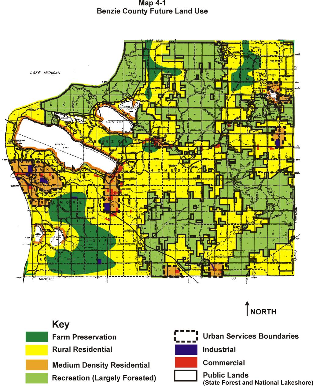
2 natural resources important to Benzie citizens, and increased costs to live in the County. The pattern selected is a more compact and nodal pattern of growth. It was found to be the most sustainable, the one that is the most fiscally responsible, the one that best retains scenic beauty and recreation opportunities and the one that best protects natural resources. Chapter 5 of this document lists basic policies to be implemented to achieve the desired future land use pattern. Vision-Based, Policy-Driven Compact Future Land Use Pattern The compact and nodal settlement pattern selected is vision-based and policydriven. It is linked to principles and strategies based on a set of goals, objectives, and actions whose root is in the vision of the County expressed by citizens, local officials and various stakeholders in the first phase of the County planning process (see Benzie County Vision). The Future Land Use Map is a visual representation of the vision. The text in this chapter supports that plan and the map. To gain the best understanding of the future land use pattern proposed by this Plan, use the map and the text together. In your mind, move about the County and picture how the land use pattern would change depending on where you were in the County. Don't try to fix on the use of a particular parcel or the edge of one land use. The map expresses general policy, not the application of a particular set of regulations to a particular property. The scale is not sufficient to depict use on a parcel basis. The zoning ordinance may be used for that purpose. Following is a description of the various land use categories illustrated on the vision-based Future Land Use Map (see Map 4-1). However, since this land use arrangement is linked to a variety of public infrastructure improvements and land use policies, to the extent these lend themselves to illustration, they are depicted on the policy maps. Maps 4-2 through 4-8 should be studied and considered together because they are designed to be implemented in tandem with the Future Land Use Map. The overall land use pattern proposed for 2020 is both compact and nodal. It concentrates the most intense residential, commercial and industrial development within urban services districts. The area affected expands beyond where urban services are provided in The area that is public land in 2000 is proposed to remain public in 2020 and continues to be primarily dedicated to recreation, open space and forestry. Agriculture preservation areas focus on retaining orchards and farms as the primary land use. Rural residential areas are devoted to very low density residential use. Higher density residential development is found in or adjacent to existing villages, cities, established resort areas and around inland lakes. 4-2
3 4-3
4 4-4
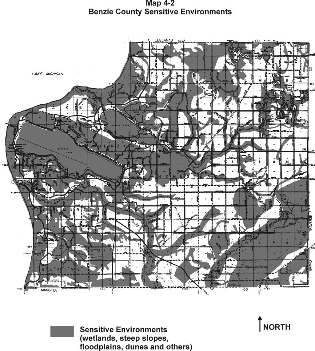
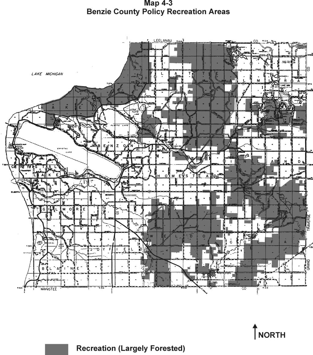
5 Sensitive Environment Protection Areas This category includes the following sensitive features: wetlands, steep slopes, dunes, floodplains, streams, rivers and lakeshores. Floodplains and wetlands would not be developed. Shoreline areas of streams, rivers and lakes would have waterside buffer plantings to filter stormwater and provide shade and wildlife habitat. Steep slopes would not be built upon or limited development would employ special design and construction approaches to prevent erosion and limit scenic impact. Dunes with special habitat would have no or limited development. Such areas would be prioritized for acquisition by conservancies or public agencies. (See Maps 4-1 and 4-2). Public Lands & Recreation This category includes public and private parks, campgrounds and marinas, public and private golf courses, the State Forest, National Lakeshore and marshes, non-motorized trails and open space corridors. To the extent possible, they interconnect. They also take advantage of natural wildlife or open space corridors such as rivers, creeks and drains. This land use category occurs throughout the County and occupies a significant percentage of the total area of the County. (See Maps 4-1 and 4-3). Agricultural Protection Areas Agriculture includes active grain farms, orchards, vineyards, u-pick farms and livestock raising operations. It also includes fallow fields and other land not actively farmed. This category also includes large lot residential uses. Future residential density would be at an average density of one dwelling unit per 40 acres. Although there is already existing residential development on five or ten acre lots in much of this area, a new maximum lot size for future development would be much smaller in order to preserve large, contiguous areas of land for farming. Depending in part on soil capacity for septic systems, maximum lot size for non-farm residences would be about 2 acres except where soils were not suited for farming. At this density, a 160 acre farm could be permitted four lots for nonfarm residences, which could be clustered together (where at most 8 acres would be used). As a result of this clustering, the remaining land would be in open space or agriculture. The Agriculture Preservation area occurs primarily in the northern and western portion of the County. This approach would work best if teamed with a purchase of development rights (PDR) or transfer of development rights (TDR) program so that farmers could capture the full development value of the land, even though only a small part of it was used for new residences. This area should be delineated more carefully as a result of a separate Agriculture and Open Space Preservation Plan. (See Maps 4-1 and 4-4). 4-5
6 4-6

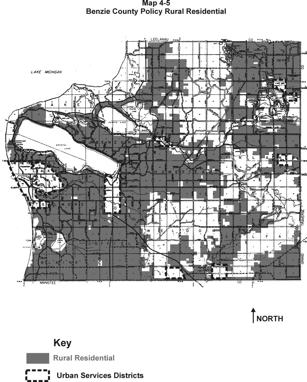
7 Rural Residential This category accommodates low density residential use in rural areas on lands not as well suited for long-term agricultural production. Agriculture is permitted as long as it remains viable, but not concentrated animal feeding operations. Average residential density is one dwelling unit per ten acres although lot sizes would vary. Sewage disposal would be by private, on-site septic systems. Where possible, dwellings would be clustered on smaller lots (to leave more open space), with individual septic systems or served by small package treatment systems or a common septic system if approved by the District Health Department and Michigan Department of Environmental Quality. This land use 4-7
8 occurs primarily in the portions of the County that are not publicly owned nor suitable for higher density. This is the largest land use category in percentage of the total area of the County. (See Maps 4-1 and 4-5). Medium Density Residential The medium density residential category includes single family residential development with a range of densities. Generally, these are from about one dwelling unit per 1-2 acres to four dwelling units per acre. However, within the villages the density may rise to 8 or more units per acre. This category of residential development occurs primarily along the developed shoreline, in Frankfort, villages and scattered historic settlements. Homes in this category would generally be served by public sewer and water, except for the extensive lakeshore strips on the larger lakes. Most of this land use would be within the Urban Services District (see page 4-7). Also in or adjacent to cities and villages within the Urban Services District would be affordable housing such as low and medium rise apartments, townhouses and mobile home parks (usually at a density slightly greater than six dwelling units per acre) (See Map 4-1). Business/Commercial Strip shopping malls, grocery stores, gas station and convenience stores, commercial business districts and small town commercial centers are included in this land use category. These are primarily located in the old city and village centers, along selected major roads leading into existing towns and in settlement nodes. In total land area, this land use does not occupy much land. However, this category occurs in key areas convenient to residents and travelers. Most, but not all, of this land use would be within a proposed Urban Services District. It is specifically omitted along most of US-31 from Honor east to the Benzie County line in order to discourage strip commercial development in this area. (See Map 4-1). Industrial Industrial development includes light manufacturing, warehousing, landfills, power plants and vacant land in designated industrial parks. These occur primarily in Frankfort and near major roads. Most of this land use would be within the Urban Services District. There are also a few scattered industrial sites. These are largely agricultural processing plants. It is convenient to have these latter facilities close to the orchards. (See Map 4-1). 4-8
9 Policy Maps Following is a description of individual policy maps. Each map should be thought of as a layer of a single map, that together expresses all of the policies in the Comprehensive Plan. Some of the policy layers of Maps 4-2 through 4-8 are the same as the Future Land Use Map. They are re-described here with a policy focus, so that all layers of the policy map are described. Together these descriptions outline policies and actions that would need to be taken to implement the vision-based future land use pattern. Sensitive Environments Sensitive environments are illustrated on Map 4-2. Sensitive environments includes forests and sensitive features such as steep slopes, wetlands, floodplains, lakes, streams and drain corridors. These sensitive environments will be provided a higher level of protection, including limited or no development (in some cases) and special design requirements for permitted development such as buffers and setbacks. Development would be prohibited in floodways and on wetlands. Setbacks would be required for structures built near streams and wetlands. Vegetation buffer strips would be required adjacent to streams, drains, wetlands and other surface water bodies. Best management practices such as vegetation strips would be required along surface water bodies to filter and lower the temperature of stormwater runoff. Commonly accepted management practices would be implemented in agriculture areas where not already practiced. Sensitive environments are scattered throughout the County. For example, there may be a stream corridor that passes through the Agriculture Preservation area, as well as the Rural Residential area before crossing into the Urban Services District (see page 4-7). Special protection efforts should be implemented in each of those areas, although the protection techniques may be different. Recreation The policy map for recreation provides interconnected open space to serve the diverse recreational and green space needs of residents and to attract tourists (see Map 4-3). This open space network will provide multiple benefits including: the amenity of nature and open spaces; recreational opportunities for walking, biking and cross-country skiing on trails; as well as habitat for wildlife. This area is largely forested. Areas within the recreation corridors that are not forested should be permitted to grow into forest and other plant communities such as meadows or prairies. This will create edges of forests that are also important to wildlife. Some timber cutting or controlled burning may be needed to manage wildlife and prevent fire fuel build-up. Agriculture Protection Within the Agriculture Preservation area (Map 4-4) it is the policy to preserve farmland and prevent the premature conversion of farmland to other land uses. New single family dwellings could be permitted if clustered at a low average density, and if sited on land not well suited to agriculture. 4-9
10 Public sewer and water would not be extended into this area during the planning period. The Agriculture Preservation area implements an average density of one unit per 40 acres. This is not the same as a 40 acre minimum lot size. Through clustering and use of small maximum lot sizes (0.5-2 acres, depending on soil suitability for septic), large parcels of viable farmland could remain. Through clustering, farmers would still be able to capture some development value as well. The Agriculture Preservation area would be the principal target of agricultural preservation programs like purchase of development rights and transfer of development rights, expanded PA116 enrollments and agricultural security areas. These measures would also help preserve rural and scenic character as well. Rural and scenic character is protected by maintaining large, undeveloped parcels and through design guidelines for rural roadsides. It is the policy of the Comprehensive Plan to support "Right to Farm." Rural, nonfarm residential uses do not take precedence over farming operations. Farming practices can be objectionable to non-farm residents. However, farming is important and where buffers do not exist to moderate the dust, noise, odors and sprays from farms practicing commonly accepted agricultural management methods, non-farm residents will have to learn to live with their farming neighbors. Rural Residential This map layer shows the policy to provide for rural, low density living, but does not focus on the preservation of farmland (see Map 4-5). Farming would be allowed to continue as long as it were viable, but not concentrated animal feeding operations. The average density for this area is one unit per 10 acres, although it is not the policy to promote 10 acre minimum lot size. This density will result in providing an adequate amount of land for rural residences with on-site septic systems. If the density were higher, there would, over time, be severe negative impacts on the County road system. Public sewer and water would not be extended into this area during the planning period. Rural clustering could be used to preserve more common open space in this part of the County. It may be necessary to promote one-third to two acre maximum lot size and some package treatment sewer systems to preserve significant open space. It is also the policy of this Plan to promote design guidelines for rural residential properties. These volunteer guidelines would show property owners how to design and manage their properties for maximum scenic character. This could be 4-10
11 one of the single, most important tools to insure the vision for Benzie County is realized. In many areas, rural residential uses will be adjacent to farmland preservation areas. Farming operations will be given precedence over residential use of land under Right-to-Farm guidelines. Transportation Improvements Transportation facilities (roads, bridges and air) should be maintained or improved where they will serve the planned density of development in an area and movement between that area and others. Transportation facilities should not be improved for the purpose of fostering development at a density level above that planned for the area, or prematurely in an area where density levels would not support the cost of road improvements or future maintenance. Within existing small towns, bicycle paths and sidewalks should be installed to meet nonmotorized transportation needs. Transit service should be offered as well. Proposed transportation improvements are illustrated on Map 4-6. Job Centers Job Centers are areas of commercial, industrial and institutional use. Areas identified on Map 4-7 are based on existing job centers as depicted on the 1996 existing land use map, with reasonable expansion to the year New job centers should not skip to new locations that are scattered and expensive to serve. This is a double whammy if it also leads to an abandonment of existing centers. Almost all job centers are within an urban services district. The few that aren t are already in existence or are already zoned as such and lack public sewer and water. Urban Services District (USD) Proposed Urban Services Districts (USD) are illustrated on Map 4-8. These are the proposed areas that will be considered for extension of public sewer, water, stormwater, increased police and fire and other urban services through the year They surround the City of Frankfort and existing villages in the County. All proposed medium density residential development and nearly all commercial, industrial and institutional development would occur within an USD to ensure that adequate public services are available. Except for public sewer installed around inland lakes to resolve or prevent water pollution problem, public sewer and water would not be extended beyond the boundaries of a USD within the time frame of this Plan. The USDs will help ensure fiscal responsibility and wise use of land resources. Within USDs, densities must be high enough to adequately support urban services at a level that is economically feasible to furnish them before urban services will be implemented. Each community will need to calculate the density 4-11
12 needed to support the extension of services without unnecessarily increasing taxpayer burden. Existing infrastructure within USDs will be maintained, upgraded and incrementally expanded before new infrastructure is built in undeveloped areas of the County. The exception is in the new USD proposed for the area including the new elementary school in Inland Township. 4-12
13 4-13
14 4-14
15 4-15
16 4-16
17 Policy Maps yet to be Developed Two important policy maps need to be prepared based on further study, resource inventories, citizen input and consensus building. These are: Agriculture and Open Space Preservation. One of the recommendations of the Comprehensive Plan is to prepare an Agriculture and Open Space Preservation Plan. This task will take several years to complete. The policy map would include recommendations on specifically where to protect farmland and open space through purchase, conservation easement, or inclusion in agriculture security areas, PDR or TDR programs. It would also include recommendations as to where to improve scenery, where and how to protect existing scenery, what design guidelines are needed, where to apply guidelines for sign design and other related techniques. Watershed Plans. The Comprehensive Plan recommends completion of watershed management plans for each of the major watersheds of Benzie County. Policy maps would depict areas of the watersheds where specific actions should take place to protect water quality, fish and wildlife habitat. These actions depend on land use, soils, slope and other factors. Implementation actions could include, but are not limited to: imperviousness limits, stormwater management approaches and chemical use guidelines. Zoning Plan Section XII Land Use Classifications (pages 26-28) of the 1993 Benzie County Land Use Plan is retained (by reference) as the zoning plan portion of this Comprehensive Plan. It provides the basis for the zoning districts in the County Zoning Ordinance until a new Agricultural and Open Space Preservation Plan for the County is complete. At that time, changes to zoning districts are anticipated to reduce the impact of over-zoning in rural parts of the County and to provide new incentives to landowners to keep land in agriculture and open space uses. The next chapter sets for the principles, strategies and policies inherent in the various layers of the Future Land Use Map. Chapters 4 and 5 are designed to be read and used together when considering the consistency of a proposed land use or infrastructure proposal with the Comprehensive Plan. 4-17
Municipal Plan*Assessment
 Municipal Plan*Assessment This tool was developed to assist in reviewing municipal master plans and in determining if these plans are consistent with smart growth principles, neighboring municipal plans,
Rural Land Use Designations Kittitas County December 6, 2007 Draft
 KITTITAS COUNTY COMMUNITY DEVELOPMENT SERVICES 411 N. Ruby St., Suite 2, Ellensburg, WA 98926 CDS@CO.KITTITAS.WA.US Office (509) 962-7506 Fax (509) 962-7682 Rural Land Use Designations Kittitas County
Town of Peru Comprehensive Plan Executive Summary
 Town of Peru Comprehensive Plan Executive Communities that plan grow by choice, not by chance. A plan makes growth thoughtful, understandable, and predictable. A plan shows that a community is managing
Improve Neighborhood Design and Reduce Non Point Source Water Pollution
 HOW TO Planning Guide Improve Neighborhood Design and Reduce Non Point Source Water Pollution This document was funded by a grant from the New Hampshire Coastal Program with funding from the National Oceanic
THREE-STEP DESIGN PROCESS FOR OPEN SPACE SUBDIVISIONS
 00216106.DOC NMA/RRK 1/30/14 THREE-STEP DESIGN PROCESS FOR OPEN SPACE SUBDIVISIONS Open space subdivisions, sometimes called cluster developments, maintain a significant portion of a development site in
Minnesota Department of Natural Resource - Natural Resource Guidance Checklist Conserving Natural Resources through Density Bonuses
 Minnesota Department of Natural Resource - Natural Resource Guidance Checklist Conserving Natural Resources through Density Bonuses NRDB Why Use Density Bonuses & This Checklist Local units of government
Riparian Buffer on the Bushkill Creek. Policies
 Riparian Buffer on the Bushkill Creek Riparian buffers provide numerous benefits to landowners and the community by protecting groundwater recharge areas, providing flood control, providing stormwater
Hibbing. Land Use. Hibbing Comprehensive Plan 8.1. Land Use
 Hibbing 8.1 Introduction 8.3 Information and Assessment 8.5-8.14 Recommendations 8.15-8.17 Implementation 8.18-8.19 8.2 Introduction Although land use was not identified as a discrete goal during the community
Regional Context Statement
 Regional Context Statement REGIONAL CONTEXT STATEMENT 3. REGIONAL CONTEXT STATEMENT In 1995, the Provincial Government passed into law the Growth Strategies Act. The purpose of this provincial initiative
Environmental Protection Ordinances (Performance Zoning) Bedminster Township, Bucks County
 Bedminster Township, Bucks County") Environmental Protection Ordinances (Performance Zoning) Bedminster Township, Bucks County ARTICLE VI. PERFORMANCE STANDARDS Section 600 Compliance All uses, activities, subdivisions and/or land developments
Environmental Protection Ordinances (Performance Zoning) Bedminster Township, Bucks County ARTICLE VI. PERFORMANCE STANDARDS Section 600 Compliance All uses, activities, subdivisions and/or land developments
Gloucester County s Comprehensive Plan. The Community Connection
 Gloucester County s Comprehensive Plan The Community Connection Current Comp Plan Adopted in 1991 with a 20 year planning horizon Updated in 1995 with Part V- Implementation Recommendations and Appendix
CHAPTER SIX THE MASTER LAND USE PLAN
 CHAPTER SIX THE MASTER LAND USE PLAN What does Moran Township want to look like in twenty years? The Planning Commission has used the information gathered in this document, along with public input, to
2.0 AREA PLANS. Lakeside Business District. Lakeside Business District Land Use Categories:
 Lakeside Business District Lakeside Business District Land Use Categories: Campus Commercial Campus Commercial means a mixture of uses which includes corporate offices, office parks, hotels, commercial,
Green Infrastructure Policies and Ordinances
 Green Infrastructure Policies and Ordinances October 23, 2013 By Karen Firehock, Green Infrastructure Center 2013 Georgia Urban Forest Council s 23 rd Annual Conference The mission of the nonprofit Green
Chapter 13: Implementation Plan
 Implementation A. Introduction The Implementation Plan, in table form on the following pages, provides a summary of all the Action Items recommended in Chapters 2 through 12. The table also indicates which
NEW CASTLE COUNTY S ZONING DISTRICTS
 NEW CASTLE COUNTY S ZONING DISTRICTS This is general information about New Castle County s zoning districts. The information included is by no means exhaustive or complete. Before designing plans to develop
TRANSPORTATION AND LAND USE
 CHAPTER 10 TRANSPORTATION AND LAND USE Transportation and land use are intimately linked. The expansion of a highway typically spurs housing, employment growth and land development in the communities that
Chapter IV: Development Pattern
 Chapter IV: Development Pattern Introduction The 2002 Prince George s County Approved General Plan designates three growth policy tiers Developed, Developing, and Rural as well as three center designations
Sorted citizen input comments in review of Blount County plans July, August, and September 2007
 Sorted citizen input comments in review of Blount County plans July, August, and September 2007 The following presents sorted citizen input comments from three sessions held in July, August and September
SALISBURY TOMORROW Our Vision
 SALISBURY TOMORROW Our Vision Salisbury is committed to supporting a high quality of life and sense of community for all residents. These commitments need to be reflected in our community programs, services
TOWN OF BETHLEHEM OPEN SPACE CONSERVATION PLAN PUBLIC MEETING: OCTOBER 12, 2017
 TOWN OF BETHLEHEM OPEN SPACE CONSERVATION PLAN PUBLIC MEETING: OCTOBER 12, 2017 Welcome and Agenda 6:00 6:45: Open House, Part One 6:45 7:15: Presentation and Questions 7:15 8:00: Open House, Part Two
LAND USE Land Use 219
 3.2 2040 LAND USE One purpose of the 2040 Plan is to provide a public policy basis for making decisions regarding growth and development in the County. The number, size, and complexity of land use proposals
A Growing Community Rural Settlement Areas
 Town of Huntsville Official Plan Review - POLICY BACKGROUND PAPER A Growing Community Rural Settlement Areas BACKGROUND: In addition to the fully municipally-serviced Urban Settlement Area and the Hidden
Ten Mile Creek Planning Area
 PLANNING AREA POLICIES TEN MILE CREEK Ten Mile Creek Planning Area Location and Context The Ten Mile Creek Planning Area ( Ten Mile Creek area ) is located south of the current Boise AOCI, generally south
Chapter 10 IMPLEMENTATION RECOMMENDATIONS
 Chapter 10 IMPLEMENTATION RECOMMENDATIONS The recommended land use plan presented in the previous chapter provides a design for the attainment of the urban and rural development and open space preservation
PORT WHITBY COMMUNITY
 PORT WHITBY COMMUNITY SECONDARY PLAN UPDATE COMMUNITY IMPROVEMENT PLAN URBAN DESIGN GUIDELINES September 2015 DRAFT PROPOSED AMENDMENT NUMBER # to the Whitby Official Plan PURPOSE: The intent of this Amendment
COMMUNITY DESIGN. GOAL: Create livable and attractive communities. Intent
 COMMUNITY DESIGN Intent An attractive, well-designed County will attract quality development, instill civic pride, improve the visual character of the community, and create a strong, positive image for
Brice Prairie Master Plan
 Brice Prairie Master Plan Town of Onalaska Community Meeting #1 Sand Lake Elementary School January 28, 2006 9 am 11 am Agenda Background What is a Master Plan? Brice Prairie Capacity Reports Starter Ideas
Major Subdivision Sketch Plan Checklist
 This checklist provides specific requirements that are apart of the Sketch process. The entire process is described by the Huntersville Subdivision Review Process which details all the submittal and resubmittal
ARTICLE VI AGRICULTURAL PROTECTION DISTRICT
 A. Findings and Purpose ARTICLE VI AGRICULTURAL PROTECTION DISTRICT The Town of Northumberland finds that the protection of agriculture is essential to the implementation of the goals and objectives ofthe
Land Use. Chapter 8: Introduction. Land Use Vision. Section I: Current Land Use 8-1
 Introduction Land use is the defining element of the comprehensive plan. It will serve as a framework for decision makers, guiding future growth and development in the Town of Oconto Falls. This chapter
3.10 LAND USE SETTING PROJECT SITE EXISTING LAND USE DESIGNATIONS AND ZONING. General Plan Land Use Designations.
 This section of the Draft EIR addresses the existing land uses on and adjacent to the project site and discusses the potential impacts of the proposed project on existing land uses. Key issues addressed
6 PORT SYDNEY SETTLEMENT AREA
 Section 6 Port Sydney Page 61 6 PORT SYDNEY SETTLEMENT AREA 6.1 Basis and Principles Village of Port Sydney Waterfront Community Existing Services 6.1.1 Port Sydney is an historic settlement that has developed
Chapter 1 Vision Statement & Goals
 Chapter 1 Section 1.1 Section 1.2 Section 1.3 Section 1.4 Section 1.5 Introduction Vision Statement Visioning Exercise Prioritization of Land Use Issues Goals of the Comprehensive Plan CHAPTER 1 SECTION
Warren County/Bowling Green Focus 2030 Comprehensive Plan VOLUME 1 INDEX
 Appendix 5: Index VOLUME 1 INDEX A Aesthetics ES-6, FLU-15, FLU-17, FLU-24, NCR-7 Agricultural Base FLU-18, FLU-20 Agricultural Centers, Rural FLU-11 Agricultural District NCR-17-NCR-18 Agricultural Economy
3. VISION AND GOALS. Vision Statement. Goals, Objectives and Policies
 Vision Statement Queen Creek s interconnected network of parks, trails, open spaces and recreation opportunities provide safe and diverse activities and programs that sustain its unique, small town, equestrian
A. Selma Park, Davis Bay and Wilson Creek
 A. Selma Park, Davis Bay and Wilson Creek This waterfront neighbourhood consists of three separate community areas, linked by Highway 101, but with different character, land use patterns and future potential.
Chapter 6: Community Character
 Chapter 6: Community Character The term "community character" covers a broad spectrum of concerns. First and foremost, community character is a visual concept. In Long Grove, however, community character
IV. Development in the Rural Overlay District
 Intracoastal Waterway Route 17 Route 168 Great Dismal Swamp VIRGINIA NORTH CAROLINA IV. Development in the Rural Overlay District IV-1 Route 17 in Chesapeake s Rural Overlay District affords distant views
Procedures IV. V. Rural Road Design Option
 i IV. Procedures A. All applicants required to prepare a Conservation Design Subdivision shall provide the Planning Board with a conceptual conventional subdivision design as well as a proposed layout
BROOKHILL NEIGHBORHOOD MODEL ZONING MAP AMENDMENT PREFACE TO APPLICATION
 BROOKHILL NEIGHBORHOOD MODEL ZONING MAP AMENDMENT PREFACE TO APPLICATION June 15, 2015 Revised: August 1, 2016 I. VISION Brookhill is a proposed community based upon the principles of Albemarle County
TOWN OF SPRINGFIELD, NEW HAMPSHIRE
 TOWN OF SPRINGFIELD, NEW HAMPSHIRE NATURAL RESOURCES INVENTORY EXECUTIVE SUMMARY March 2008 Prepared by: Watershed to Wildlife, Inc. Natural Resource Consultants 42 Mill Street, Suite 3 Littleton, NH 03561
Section 4 BUILDING THE MASTER PLAN
 The Master Plan 33 Section 4 BUILDING THE MASTER PLAN Figure 4:1. A collaborative effort characterized the two design workshops sponsored by DISC to create hypothetical Master Plans for the Towers Property
ARTICLE 6: Special and Planned Development Districts
 ARTICLE 6: Special and Planned Development Districts 6-10 Traditional Neighborhood Development (TND) District 6-10.10 Purpose and Intent The Traditional Neighborhood Development (TND) District provides
2018 Northampton Township Comprehensive Plan
 2018 BUCKS COUNTY, PENNSYLVANIA What is a? A comprehensive plan is a municipality s main policy document that details the collective vision for the future, the historic, environmental, and cultural facilities
CHAPTER 22 Rural Open Space Community Developments
 CHAPTER 22 Rural Open Space Community Developments Section 22.1 Description and Purpose The intent of this Chapter is to offer property owners an alternative to traditional zoning requirements for rural
FUTURE LAND USE PLAN 7
 FUTURE LAND USE PLAN 7 The recommendations of each of the preceding chapters can be combined to present an overall Future Land Use Plan for Wilton. The Future Land Use Plan, presented on the following
LAND USE ELEMENT. Purpose. General Goals & Policies
 LAND USE ELEMENT Purpose This Land Use Element contains the goals and policies necessary to support the City s responsibility for managing land resources and guiding development through implementing regulations,
Washtenaw County Department of Planning & Environment
 Washtenaw County Department of Planning & Environment 9/12/2007 Trudy Feldkamp, Planning Commission Secretary 7887 Klager Rd. Saline, MI 48176 Re: General Development Plan for Saline Township Review Dear
ELIGIBILITY CRITERIA CHECKLIST OPEN SPACE CLASSIFICATION
 THURSTON COUNTY DEVELOPMENT SERVICES OPEN SPACE TAX PROGRAM ELIGIBILITY CRITERIA CHECKLIST OPEN SPACE CLASSIFICATION Use this checklist to help you determine whether your property is eligible for open
Exhibit A. 8:9 Scuffletown Rural Conservation District
 Exhibit A 8:9 Scuffletown Rural Conservation District 8:9.1 Intent and Purpose The Scuffletown Rural Conservation (SRC) District is intended to provide for residential development that supports the development
TERRESTRIAL NATURAL HERITAGE SYSTEM STRATEGY APPENDIX F: MODEL POLICIES FOR THE IMPLEMENTATION OF THE TARGET TERRESTRIAL NATURAL HERITAGE SYSTEM
 TERRESTRIAL NATURAL HERITAGE SYSTEM STRATEGY APPENDIX F: MODEL POLICIES FOR THE IMPLEMENTATION OF THE TARGET TERRESTRIAL NATURAL HERITAGE SYSTEM C H A P T E R 1 M O D E L P O L I C I E S F O R I M P L
CHAPTER 7: VISION AND ACTION STATEMENTS. Noble 2025 Vision Statement
 CHAPTER 7: VISION AND ACTION STATEMENTS This chapter presents the vision, policy and action statements that transform the comprehensive planning study, an analysis of Noble s past, future trends and community
AREASTRUCTURE PLAN AMENDMENT COCHRANE NORTH
 AREASTRUCTURE PLAN AMENDMENT COCHRANE NORTH In order to implement the vision outlined in the Conceptual Scheme, the following three amendments to the Cochrane North ASP are proposed: 1. Allow commercial
3 Vision and Goals. Vision and Goals. Blueprint for Bloomsburg. Vision. Town of Bloomsburg Comprehensive Plan,
 Vision and Goals 3 Vision and Goals Citizens of the Town of Bloomsburg clearly value their natural and cultural heritage, the walkable, mixed use pattern of downtown, the access to education, and the community
4 Sustainability and Growth Management
 4 Sustainability and Growth Management Introduction Traditionally, has assumed growth and development with limited consideration for the long-term negative social, environmental or economic impacts on
APPENDIX A 6 CONCEPTUAL PRELIMINARY PLAN GUIDE AND CHECKLIST FOR MAJOR SUBDIVISIONS CARRBORO DEVELOPMENT GUIDE APPENDIX A
 6 CONCEPTUAL PRELIMINARY PLAN GUIDE AND CHECKLIST FOR MAJOR SUBDIVISIONS Conceptual Preliminary Guide/Checklist for Major Subdivisions Page 1 FORM: REVIEW DATE: CONCEPTUAL PLAN REVIEW 2000 REVIEWED BY:
This page intentionally blank.
 This page intentionally blank. Parks, Recreation, and Open Space Chapter Relationship to Vision Vision Parks, Recreation and Open Space Chapter Concepts County Government. County government that is accountable
Chapter 8: Land Use. Key Issues. Introduction. Stakeholders. Survey Results. Purpose
 Chapter 8: Land Use Introduction Of the approximately 793,000 acres within Dane County s borders, approximately 182,000 acres, or almost 23%, are covered by water, wetlands, regulated buffers, floodplain
Dwelling Units Max 12 dwelling units per acre/min 8 dwelling units per acre. Development Mix 80% non residential/20% residential
 13. OSTEEN LOCAL PLAN Background: The Osteen Local Plan area is located in southwest Volusia County along the SR 415 corridor between Lemon Bluff Road and Acorn Lake Road and includes 3,990 acres. The
Land Use & Transportation Primer
 Land Use & Transportation Primer Presented By Smitha Vijayan Center for Urban Transportation Studies University of Wisconsin-Milwaukee Role of Local Government Land use decision-making power mostly given
CHAPTER 3 VISION, GOALS, & PLANNING PRINCIPLES. City of Greensburg Comprehensive Plan. Introduction. Vision Statement. Growth Management Goals.
 CHAPTER 3 VISION, GOALS, & PLANNING PRINCIPLES Introduction The Greensburg Comprehensive Plan is intended as a working community document. A combination of long and short-term goals, this document is intended
Innovative Land Use Techniques
 Innovative Land Use Techniques A Handbook for Sustainable Development Eric Williams, Assistant Administrator, NHDES Carolyn Russell, Principal Planner, NHDES Cliff Sinnott, Executive Director, RPC Jill
MAYFIELD WEST SECONDARY PLAN PHASE 2
 MAYFIELD WEST SECONDARY PLAN PHASE 2 Public Open House #3 February 25, 2010 Draft Preferred Land Use Scenario TOWN OF CALEDON PLANNING & DEVELOPMENT DEPARTMENT Open House Agenda TOWN OF CALEDON 1. Welcome
Access Management: An Overview
 Figures 1-5 Below Evolution of development along a highway. In the early stages, land along the road is used for farming with little traffic generated. As time passes, the highway corridor becomes a de
Please read the entire document
 projects impacting the waterfront revitalization area. The waterfront revitalization area of the town will have to subareas to the west and east of the village. Page 6 of 6 Wayfinding master plan create
Working Group Meeting
 April 4,, 2017 Parks Operations Bldg Working Group Meeting Arts Districts Overview Stormwater/RPA/Stream Considerations First Principles Agenda 7:00pm 7:05pm 7:10pm 7:40pm 8:30pm 9:40pm 9:45pm Welcome
Draft CHAPTER TWO THREE LAND USE PLAN
 CHAPTER TWO THREE LAND USE PLAN LAND USE PLAN The basic intent of the comprehensive planning process is to provide a well-founded and coordinated decision-making framework to guide both public and private
E. RURAL COMMERCIAL/INDUSTRIAL PARK MODEL
 E. RURAL COMMERCIAL/INDUSTRIAL PARK MODEL 1. PURPOSE The purpose of the Rural Commerce/Industrial Park Model is to provide parameters within which a grouping of business buildings with parking, loading
LAND USE MEADOWS PLANNING AREA
 LAND USE MEADOWS PLANNING AREA I. Profile of Meadows Planning Area A. Location Meadows Planning Area is delineated by I-5 on the north, the Nisqually Bluffs representing the growth boundary on the east,
CITY OF TIGARD EXPECTED SERVICE AREA
 CITY OF TIGARD EXPECTED SERVICE AREA City overview / Background Incorporated in 1961, the has experienced rapid growth over the years. This growth can be attributed to many factors, primarily the close
2 PLANNING AREA DESCRIPTION
 2 PLANNING AREA DESCRIPTION 2.1 LOCATION Hecker Pass is located within the City of Gilroy near the western city limit. Figure 2-1 illustrates the regional location of the Hecker Pass Area. Figure 2-1:
EXECUTIVE SUMMARY DRAFT CHAPTER 1 INTRODUCTION EXECUTIVE SUMMARY
 CHAPTER 1 EXECUTIVE SUMMARY INTRODUCTION Through the joint efforts of the City of Tulsa planning staff and the Land Services division of Indian Nations Council of Governments (INCOG), the Berryhill Land
The transportation system in a community is an
 7 TRANSPORTATION The transportation system in a community is an important factor contributing to the quality of life of the residents. Without a sound transportation system to bring both goods and patrons
Chapter 5: Natural Resources and Environment
 NATURAL RESOURCES AND ENVIRONMENT 5-1 5 Chapter 5: Natural Resources and Environment BACKGROUND AND INTENT Urban expansion represents the greatest risk for the future degradation of existing natural areas,
Rural Conservation. Rural Conservation. Moving Forward ~ Planning Ahead. Introduction
 Introduction Minnehaha County expresses at least two very different styles of character. The City of Sioux Falls provides a strong urban atmosphere because of its size and regional status, and the unincorporated
Chapter 5: Recreation
 Chapter 5: Recreation Introduction and Setting Recreational opportunities within Nevada County are varied, ranging from public parks with intensively used active recreational facilities, to vast tracts
Sustainable Growth. Sustainable Growth
 2 Sustainable Growth Sustainable Growth SUSTAINABLE GROWTH 2.1 COMMUNITY VISION... 2-5 2.2 THE CITY SYSTEM... 2-7 2.2.1 AREAS... 2-7 2.2.2 CITY-WIDE SYSTEMS... 2-8 2.2.3 PROVINCIAL PLAN BOUNDARIES AND
General Location Annex, Rezone & Preliminary Plat Lansdowne Addition, Unit Three
 NEWFOUNDLAND I-5 Agricultural District Subject Site SUNDANCE ANDERSON Single Family Residential CHRISTY PUD Agricultural District Highway Business General Location Annex, Rezone & Preliminary Plat Lansdowne
Growing Community Urban Settlement Area and Hidden Valley Settlement Area
 Town of Huntsville Official Plan Review - POLICY BACKGROUND PAPER Growing Community Urban Settlement Area and Hidden Valley Settlement Area BACKGROUND: Through the Provincial Policy Statement (PPS), the
HAZARD MITIGATION GOALS AND OBJECTIVES
 SEWRPC Community Assistance Planning Report No. 282, 2nd Edition CITY OF MILWAUKEE ALL HAZARDS MITIGATION PLAN UPDATE Chapter IV HAZARD MITIGATION GOALS AND OBJECTIVES [NOTE: Throughout this plan update
HELPING SMALL TOWNS AND RURAL AREAS THRIVE
 EPA Office of Sustainable Communities HELPING SMALL TOWNS AND RURAL AREAS THRIVE Village of Vinton, Texas May 30, 2013 Katharine Ange, AICP Renaissance Planning Group Overview of Workshop Discussion of
COMMUNITY ENVIRONMENTAL MANAGEMENT
 COMMUNITY ENVIRONMENTAL MANAGEMENT CEM HANDBOOK FOR COMMUNITY CONSERVATION PLANNING ----- Draft ----- Prepared by the CENTER FOR COMMUNITY ENVIRONMENTAL MANAGEMENT in association with the NEW YORK STATE
The following rules shall be used to determine the precise location of any zone boundary shown on the Official Zoning Map of Auburn:
 ARTICLE III. ESTABLISHMENT OF ZONING DISTRICTS Section 300. Establishment of Zoning Districts. The City of Auburn, Alabama is hereby divided into zoning districts of such number and character as are necessary
Planning for and Managing Open Space and Natural Areas
 Planning for and Managing Open Space and Natural Areas Increasingly, development proposals in Delaware include large amounts of open space and natural areas. While open space is important as a community
Implementation Guide Comprehensive Plan City of Allen
 Implementation Guide 2030 Comprehensive Plan City of Allen DRAFT 2015 Implementation Guide Allen 2030 Comprehensive Plan INTRODUCTION The Comprehensive Plan serves as a guide for the growth and development
CITY OF CLAREMONT MASTER PLAN 2017 CHAPTER 1: LAND USE
 CITY OF CLAREMONT MASTER PLAN CHAPTER 1: LAND USE Prepared by the Claremont Planning Board and the Claremont Planning and Development Department Vision Claremont Master Plan Chapter 1: Land Use Claremont
6 RURAL RESIDENTIAL. 6.1 Rural Use. Rural Use (RU) Goals and Objectives. Policy Goal
 Goals and Objectives. Policy Goal") 6 RURAL RESIDENTIAL The vast majority of East Hants 466,426 acres are considered rural in nature and are characterized by a great diversity of uses. Because of this, land use policies in rural areas of
6 RURAL RESIDENTIAL The vast majority of East Hants 466,426 acres are considered rural in nature and are characterized by a great diversity of uses. Because of this, land use policies in rural areas of
Woodland Conservation and the Master Plan
 1 WHAT IS A MASTER PLAN? A Vision for the Future of Your Community Woodland Conservation and the Master Plan Goals Objectives Strategies 2 How Will Your Community Look? TREE PRESERVATION AND THE MASTER
Secrest Short Cut and Monroe Expressway Small Area Plan AUGUST 29, 2018
 Secrest Short Cut and Monroe Expressway Small Area Plan AUGUST 29, 2018 Background and Process Monroe Expressway will be open by the end of 2018 Union County and Indian Trail identified a need to revisit
RECREATION, OPEN SPACE AND GREENWAYS ELEMENT GOALS, OBJECTIVES, AND POLICIES
 RECREATION, OPEN SPACE AND GREENWAYS ELEMENT GOALS, OBJECTIVES, AND POLICIES GOAL R-1: DEVELOP A RECREATION, OPEN SPACE AND GREENWAYS SYSTEM AS AN INTEGRAL COMPONENT OF AN OVERALL, COUNTY-WIDE ECONOMIC
Future Land Use and Development Policies
 Future Land Use and Development Policies Introduction This section presents policies for future development and land use, given the consensus identified through the extensive public participation process.
OPEN SPACE CHAPTER 7: OVERVIEW. Preserve open space to protect natural resources, enhance character and provide passive recreation opportunities
 CHAPTER 7: OPEN SPACE OVERVIEW Ridgefield has made tremendous progress permanently preserving areas of town as open space. Open space preservation can serve many important purposes, including: protect
Section 9 NEIGHBORHOOD DESIGN
 Section 9 NEIGHBORHOOD DESIGN City of Lancaster Comprehensive Plan D u n k i n, S e f k o & A s s o c i a t e s, I n c. NEIGHBORHOOD DESIGN INTRODUCTION There are many ways in which a neighborhood can
9 th Street Sub Area Plan
 9 th Street Sub Area Plan In the 1990 s, when the Township prepared the last Master Plan, the 9 th Street corridor was studied as part of a larger 9 th Street Focus Area that included the West Main Street
Town of Washington Master Plan & Regulatory Audit: Interim Results
 Town of Washington Master Plan & Regulatory Audit: Interim Results May 20, 2008 Presented by: 30 Bank Street Lebanon, NH 03766 www.uvlsrpc.org Introduction & Purpose Compare the Master Plan to the regulations
SECTION II SECTION II STATEMENT OF GOALS, OBJECTIVES, PRINCIPLES, ASSUMPTIONS, POLICIES AND STANDARDS
 STATEMENT OF GOALS, OBJECTIVES, PRINCIPLES, ASSUMPTIONS, POLICIES AND STANDARDS 1 2 STATEMENT OF GOALS, OBJECTIVES, PRINCIPLES, ASSUMPTIONS, POLICIES AND STANDARDS INTRODUCTION The New Jersey Municipal
INTRODUCTION Key Issues and Findings Goals, Objectives, and Policies - Natural Resources - Map M18 - Environmental Resources
 Natural, Environmental, Cu INTRODUCTION This Element provides policies related to the preservation and protection of the Centre Region s natural, environmental, cultural, and historic resources. This Element
Growth Management: Common Value 2 of Community Character
 Growth Management: Common Value 2 of Community Character 24 Why is Growth Management a Common Value? Effective Growth Management is essential to protecting our surrounding ecosystem and reinforcing our
-MENDOCINO COUNTY PLANNING AND BUILDING SERVICES- DIVISION II OF TITLE 20--COASTAL ZONING CODE
 CHAPTER 20.504 VISUAL RESOURCE AND SPECIAL TREATMENT AREAS Sec. 20.504.005 Applicability. Sec. 20.504.010 Purpose. Sec. 20.504.015 Highly Scenic Areas. Sec. 20.504.020 Special Communities and Neighborhoods.