GRANDVIEW HEIGHTS NCP AREA #3 CITIZEN ADVISORY COMMITTEE (CAC) MEETING #6
|
|
|
- Barnard Pitts
- 5 years ago
- Views:
Transcription


1 WELCOME TO THE NCP AREA #3 CITIZEN ADVISORY COMMITTEE (CAC) MEETING #6 For more information visit the city of surrey webpage at: 1 Feb 1, 2018 CAC Meeting NEIGHBOURHOOD CONCEPT PLAN PLAN AREA AREA #3 #3


2 MEETING AGENDA Agenda Outline 1. What we ve heard at Public Open House? 2. Questions & Comments about Survey 3. CAC & NCP Next Steps 4. Questions & Comments about next steps 2 CAC Meeting

3 PUBLIC OPEN HOUSE #2 - SURVEY RESULTS Grandview Heights NCP #3 Community Survey Summary The results of this survey, conducted between November 27, 2017 and January , are not weighted to the City of Surrey s population. The results are based on 464 survey responses of which 242 where completed Surveys.
4 Profile of Survey Participants Neighbourhood Area Age Range In Study Area Other part of South Surrey Cloverdale Fleetwood Guildford Newton 9% 12% 10% 5% 6% 49% 3% 15% 20% 19% 28% 12% 3% Prefer Not to Answer City Centre/Whalley Outside Surrey 2% 8% DEMOGRAPHICS Demographics are provided as background on the composition of survey respondents. Please note these results are not weighted to the City of Surrey s population.
5 Rating Priorities Provide For Community Amenities & Schools 58% 33% 6% 2% Provide Parks &Recreation Opportunities 55% 35% 7% 2% Ensure Healthy, Protected & Well-Maintained Ecosystems & Biodiversity 53% 31% 12% 2% 2% Ensure Appropriate Servicing, Financing and Infrastructure Improvements 43% 39% 14% 3% 2% Limit Urban Impacts on the Agricultural Land Reserve 52% 28% 11% 6% 3% Provide Appropriate Housing 40% 38% 17% 3% 2% Ensure Multimodal Road Design encouraging a Transit Oriented Community 41% 37% 15% 5% 2% Include opportunities for Neighbourhood Serving Commercial Uses 12% 38% 30% 13% 7% Consider Viewscape Opportunities 12% 32% 38% 12% 5% Very Important Important Neither Important Nor Unimportant Unimportant Very Unimportant Q: In early consultation with the Citizen Advisory Committee (CAC), nine draft planning priorities were developed to help guide the creation of future land use concepts for this neighbourhood. Help us rate these priorities in preparation for the next steps of the planning process. Total participants: 464
6 Other Priorities Most importantly, Surrey needs to improve walkability of neighborhoods to amenities. Surrey has not done well with this creating a city that requires cars which is the most unhealthy. We need better transit to connect out of the way residential neighborhoods with other services. A disc golf course in a park in this area. Any new development initiative that gets considered seems to always negate roadside parking space. Good example is Clayton Heights. Homes get built with suites (legal or illegal) but not enough consideration is ever given to where will people park or where will service vehicles park. No more housing developments until schools have been built, especially another high school. Create an appropriate mix of single family and townhouses with sufficient density to ensure cost of providing community services can be justified. Ensure developers pay for infrastructure upgrades required and not Surrey tax payers. Incorporating public art in common public spaces. Plan the neighborhoods properly, too much housing, and not enough doctors, dentists, daycares, grocery stores: these need to be in walking distance! Q: Are there any other planning priorities you would suggest? Total participants: 142

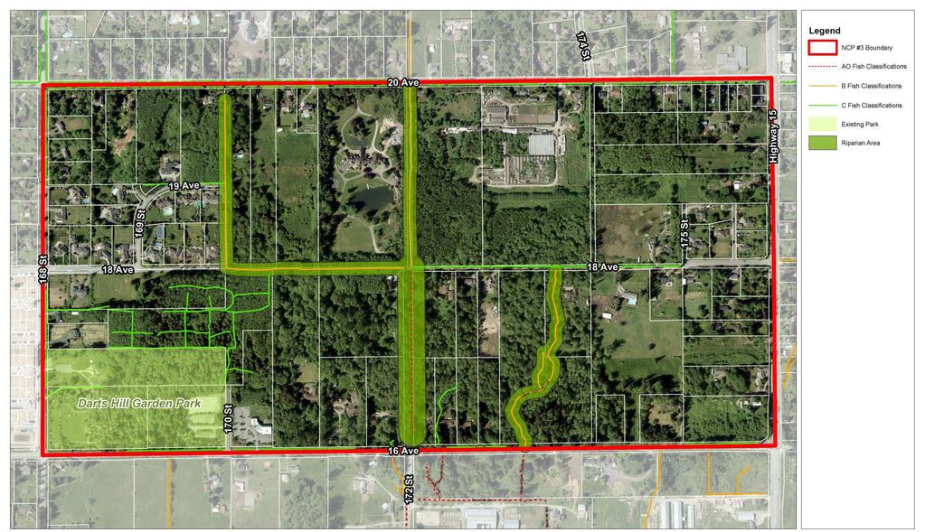
7 Habitat Corridor between Darts Hill Park and Redwood Park Q: We need to plan for a habitat corridor between Darts Hill Park and Redwood Park. Highlight on the map the best location for a wildlife corridor. Use your cursor to highlight the map. Based on CitySpeaks survey responses only.
8 New Parkland Q: New parkland for people is also important. Highlight on the map the best locations for new parkland. Use your cursor to highlight the map. Based on CitySpeaks survey responses only.

9 New Active Parkland Consolidate new parkland into one or two larger sites 44% Spread out several smaller sites across the plan area 56% Q: The amount of new active parkland will be based on the number of new residents in the area. Assuming a set amount of new parkland, how do you think it should be provided? Total participants: 291
10 Best Location for a Village Node and/or Commercial Area(s) Q: Highlight on the map the best location(s) for a village node and/or commercial area(s). Based on CitySpeaks survey responses only.


11 Neighbourhood Village Highway Oriented Commercial 8% Neighbourhood Commercial 46% Mixed Use Commercial 37% No Commercial 9% Other 1% Q: A neighbourhood village or commercial areas can take a variety of forms and support different uses. Each contributes differently to a neighbourhood. Which form of commercial building do you feel is suitable for this area? Total participants: 279
12 Neighbourhood Village/Commercial Area by Age Range 29% 5% 6% 13% 10% 11% 9% Highway Oriented Commercial 65% 53% 37% 39% 57% 47% Neighbourhood Commercial Mixed Use Commercial No Commercial 71% 24% 34% 39% 43% 21% 36% 5% 6% 11% 7% 11% 8% 19-29* Overall *Caution: Low base n<10
? Note, some areas may not redevelop so this balance would apply only to those areas that do. 100% must be assigned to move to the next question.")
13 Mix of Housing Appropriate to this Area Mean Median Detached Single Family Townhouse Semi-Detached Apartment Q: What mix of housing do you think should be provided is appropriate in this area (by percentage)? Note, some areas may not redevelop so this balance would apply only to those areas that do. 100% must be assigned to move to the next question. Total participants: 266
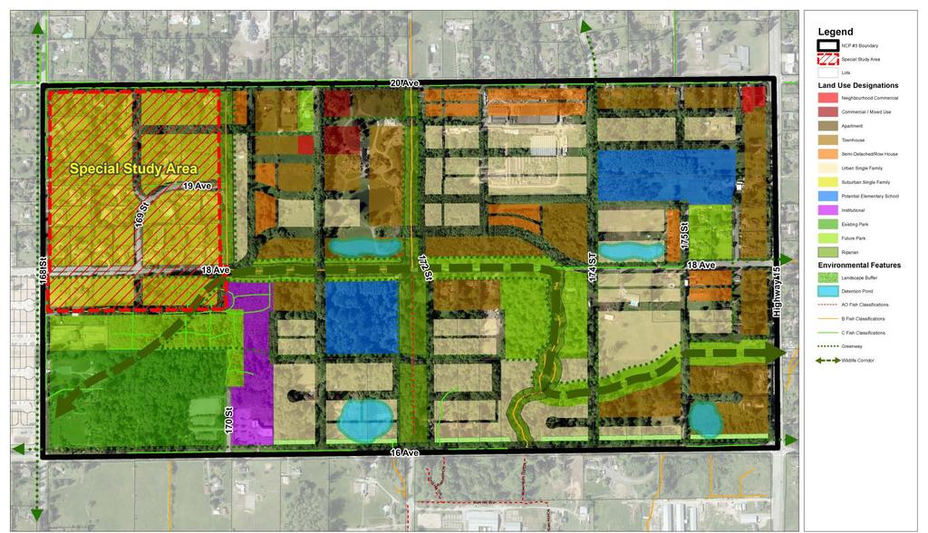
14 Residential Concepts The area should be single family and some townhomes/rowhomes. The amount of density should be driven by only having to provide one school in the area. Getting two school sites in this area will be prohibitive. Also, services and transit are not in this area so density should remain low. Higher density areas exist near 24th and 160th and in Area 2. This should be urban single family and townhomes only. Homes that allow for wheelchair/universal access for aging population. The 3 level townhouse with 2 flights of stairs don't suit seniors and people who have mobility challenges. Need to keep more large lots, rather than all tiny lots. Leave some space and trees. The roads cannot support more density so close to the all the current development. We are already short on schools, transit in the area. Roads all need widening to support the existing growth. Add more trails and walkways. Safer biking areas on the streets. Do not forget lower cost rental housing and starter homes for young singles and married with young families. We cannot afford to continue to force them out of our communities as Vancouver has done. Q: Example locations of potential housing types are illustrated above in Concept A & B, for discussion purposes. Given the ideas about where housing could be provided, do you have any additional comments about the location and type of housing for this neighbourhood? Total participants: 118 Density is far too high. High density does not fit in with the existing 1 acre lots surrounding the NCP. There are lots of semi-detached and townhouse along the 24th corridor. And plenty of commercial. There is little or no need for it here.

15 School Locations Location A 31% Location B 26% Location C 26% Location D 11% Other 6% Q: Which one of the four proposed locations would you prefer? Or alternately select other and indicate with the highlighter tool the other location on the map below. Total participants: 259 Heat map is based on CitySpeaks survey responses only.
16 School Locations Build with future expansion in mind so that instead of portables, actual classrooms can be added. And what is wrong with two-storey elementary schools? This concept would take less land allowing for more outdoor space for recreation and neighbourhood utilization. Only one school site in this area, too difficult and expensive to get two. School sites should be provided for before/during the re-development of the area to ensure schools are available for new families. The school should be located next to Dart's Hill and the existing church. There may be an opportunity for some shared amenities between the Park the School and the Church. e.g.: Daycare in the Church outdoor activities in the Park, shared parking for larger events, etc Safety should be important - for children walking to school, with wide sidewalk and crosswalk areas; as well as for drivers. Slower traffic, more vehicles on the road, make sure it's somewhere that won't create a bottleneck. Putting the school closer to the kids that will attend that school on the other side of 176 St will make it more central for everyone. I don't understand why the lot of the previous Grandview Heights Elementary can't be used? It has an old (possibly heritage) schoolhouse on the property that should be saved for some history in the area as it is linked to the founders of Red Wood Park. This would be where I would propose a new school to go. Q: Do you have any comments about Schools in the plan area? Total participants: 75
17 Hazelmere Estates Planning Concepts Maintain the status quo (existing suburban designation only): Mix of 1 acre and half acre lots (Concept 1) Urban re-development around periphery with a suburban core: Urban designation (e.g. single family/townhouse etc.) along Urban Re-development for the entire area: Mix of urban designation (e.g. single family, duplex, townhouse etc.) with potential 26% 22% 45% Urban redevelopment is great but not with the school here.. this is the last area to put a school as it is least central and is likely to be the last area developed fully. Single Family and Duplexes, with a larger then normal lot sizes. More green spaces. No further development. 50% rental apartment buildings with commercial underneath and 50% rental townhouses. Other 7% Q: What type of ultimate long term land uses may be appropriate in the Hazelmere Estates Area? Total participants: 254/14
18 Road Network and Circulation Planning Comments Long term transit connectivity is paramount; MEANINGFUL transit times to major hubs (Central City, Skytrain, Guildford, Langley Centre) required to reduce traffic on 24th, 20th, 16th avenues - connectivity to Semiahmoo or Ocean Park will not negate excessive car use. Connecting roads which go all the way thru the NCP could disrupt the wildlife corridors. Bike paths are very important in such a network. Plus adapting the network as the community grows. It is needed. We will never get people to stop driving so develop wider roads with adequate room for pedestrians and bikes. Probably need a mix of A and B. I like splitting 18th Ave around the creek area, that is a good idea. I think people are more likely to walk or bike if they can put some distance away from cars whether for exhaust, noise or safety. We enjoy walking on the new widened walkways in Grandview area. We can talk without yelling and don't have to check as often for cars or other peds. Typically, TOO MANY traffic lights - if the goal is to reduce congestion, traffic circles "of a reasonable size for each individual intersection" need to be incorporated in the design. Both concepts will only create more congestion. Q: What do you think about future roadway and pedestrian connectivity? Total participants: 137
19 Land Use Concepts Concept A 33% Concept B 67% Q: Based on the draft planning principles provided, which land use concept do you prefer? Total participants: 242
20 Land Use Concepts by Neighbourhood 52% 32% 21% 21% 50% 33% 44% 75% 34% Concept A Concept B 48% 68% 79% 79% 50% 67% 56% 25% 66% *Caution: Low base n<10

21 Questions from Open House What Percentage of Land is Park/Green? How will the city Pay for Parkland/wildlife Corridors? Why is majority of Density North of 18 th Ave? What Populations is projected.


22 Formation of Preferred Concept A B Combine features, to formulate Preferred Land Use Concept C
23
24 E QUESTIONS & COMMENTS 24 CAC Meeting
25 STAGE 1 - PLANNING SCHEDULE January April 2016 July 25 th 2016 November 23 rd 2016 January-February 2017 Late November 2017 April 2018 June/July 2018 Open House #1 CAC #5 CAC #4 CAC #3 CAC #2 CAC #1 Open House #2 CAC #7 CAC #6 Open House #3 CAC #8 Landown er petitions received by City Council authorized City Staff to begin the process of preparing a Stage 1 NCP for Grandview Heights NCP #3. Initial Public Open House #1 Select a Citizen s Advisory Committee (CAC) to work with the City to develop the NCP. Develop Terms of Reference City Staff works with the CAC and other stakeholders, as required, to develop Draft Land Use Options. Background studies, including an environmental study, heritage study, and an integrated stormwater management plan (ISMP). Public Open House #2 Draft Land Use Options Develop a Preferred Land Use Concept Public Open House #3 Preferred Land Use Concept Present Draft Stage 1 Report to Council If Stage 1 is approved by Council, initiate Stage 2 Complete We Are Here Development Applications may be processed and advanced to Council for Consideration *Note: NCP Planning Process Timelines are subject to change. 2 5 CAC Meeting
26 Specific Next Steps Completion of ISMP in tandem with Stage 1 of NCP City Interdepartment al meetings to prepare a Preferred land Use Concept City Committee Meetings Stage 1 Interagency Meeting CAC Meeting #7 (Land Use Concept Workshop) Public Open House #3 CAC Meeting #8 (Open House Review) Council Report and Stage 1 Plan Consideratio n *Note: NCP Planning Process Timelines are subject to change.
27 A Name for Grandview Heights NCP #3 Examples of names that have been given to other NCPs in Grandview Heights include Morgan Heights, Sunnyside Heights, Redwood Heights, and Orchard Grove. We welcome your suggestions and comments. If you have any suggestions for other names or comments on any of the names please let us know, and we will be bringing a list of names to the next Public Open House. Some initial suggestions from City staff include the following: Darts Hill Sam Hill Darts Village Grandview Ridge
 598-5858")
28 City of Surrey Community Planning Division Avenue Surrey, BC, Canada V3T 1V8 PHONE: PATRICK KLASSEN, COMMUNITY PLANNING MANAGER (604) MARKUS KISCHNICK, COMMUNITY PLANNER (604) Webpage: CAC Meeting
29
30
Shared Principles and Emerging Plan Directions
 Shared Principles and Emerging Plan Directions Introduction Since the Fairfield Neighbourhood planning process launched in June 2016, we have heard from many residents, businesses, groups and other people
This Review Is Divided Into Two Phases:
 Semiahmoo Town Centre Review The purpose of this review: To review the Semiahmoo Town Centre Concept Plan, originally approved in 1993, to ensure that this centre will continue to serve the needs of South
The Cambie Corridor 2015 Fall workshop series. What we heard WORKSHOP OUTLINE
 The Cambie Corridor 2015 Fall workshop series W 16 AVE Area 5 CAMBIE CORRIDOR Phase 3 What we heard ovember 21, 2015, 9am-noon, 1:30-4:30pm Peretz Centre 89 Participants* WORKSHOP OUTLIE Introductions
Southwest Fleetwood Enclave
 Southwest Fleetwood Enclave Development Concept Plan Southwest Fleetwood Enclave 1 st Land Owners Meeting April 30 th, 2012 Presentation Overview Why the Plan? ; Overview & Purpose of Study; Constraints
Building Great Neighbourhoods. Strathcona
 Building Great Neighbourhoods Strathcona March 21, 2018 Becky Redford Project Manager, Planning & Design Building Great Neighbourhoods Integrated Infrastructure Services Welcome and Purpose To provide
Key Moves in the Plan
 Key Moves in the Plan 2 Add housing that fits the neighbourhood s character Make it easier to leave the car behind Oak Bay Avenue Village plan to be completed in future planning process Future active transportation
It Takes A Village.. Preserving Rural Character In Standish
 It Takes A Village.. Preserving Rural Character In Standish A Public Workshop Hosted by Conservation and Open Space Plan Committee & Standish Corner Village Implementation Committee June 12, 2008 Desired
Clair-Maltby Community visioning
 Clair-Maltby Community visioning workshop #1 Summary April 27th, 2017 Table of Contents INTRODUCTIon 1 PURPOSE 1 CONSULTATION STRUCTURE 2 PARTICIPANT FEEDBACK 3 VISIONING EXERCISE 8 ONLINE SURVEY RESULTS
Planning and Public Consultation Process for the Preparation of a General Land Use Plan for South Port Kells TERMS OF REFERENCE
 APPENDIX "B" Planning and Public Consultation Process for the Preparation of a General Land Use Plan for South Port Kells TERMS OF REFERENCE PURPOSE South Port Kells is located in the northeastern quadrant
Crofton Manor 2803 West 41st Avenue WHAT WE HEARD. Public Consultation: Phase 1
 Crofton Manor 2803 West 41st Avenue WHAT WE HEARD Public Consultation: Phase 1 Background CROFTON MANOR What s Happening The City of Vancouver is undertaking a planning and public engagement process to
Public input has been an important part of the plan development process.
 Lakewood s Comprehensive Plan recognizes that transportation helps shape the community, and that the way the community provides for the safe and efficient movement of people affects the character of the
NO: R035 COUNCIL DATE: FEBRUARY 24, 2014
 CORPORATE REPORT NO: R035 COUNCIL DATE: FEBRUARY 24, 2014 REGULAR COUNCIL TO: Mayor & Council DATE: February 24, 2014 FROM: General Manager, Planning and Development FILE: 6520-01 SUBJECT: Town Centre
1.0 Purpose of a Secondary Plan for the Masonville Transit Village
 Report to Planning and Environment Committee To: Chair and Members Planning & Environment Committee From: John M. Fleming Managing Director, Planning and City Planner Subject: Masonville Transit Village
Welcome to the Oakridge Centre Open House
 Welcome to the Oakridge Centre Open House Why is the City hosting this event? This open house is to inform you of a rezoning application submitted to the City of Vancouver to amend the existing CD-1 (Comprehensive
Elderberry, Pioneer, Junction
 February 15, 2018 Pioneer Road Pioneer Mineral Point Road Elderberry Pleasant View Road Junction Junction Road Agenda Recap of Background Information, Open House #1 Draft Neighborhood Development Plan
Create Policy Options Draft Plan Plan Approval. Public Consultation Events. Phase 2
 Background Grandview-Woodland Community Plan In the spring of 2012, the City of Vancouver embarked on a comprehensive community planning program in the Grandview-Woodland neighbourhood. The process has
MEETING PURPOSE AND OVERVIEW
 MEETING PURPOSE AND OVERVIEW On February 23, 2012, the City of Elk Grove hosted the first of two community workshops related to the Southeast Policy Area. The workshop was held from 6:00 8:30 p.m. in the
Atlanta BeltLine Subarea 3 Master Plan Update
 Atlanta BeltLine Subarea 3 Master Plan Update April 14, 2018 Workshop Meeting 1 22 miles, connecting 45 neighborhoods 22 MILES of transit 46 MILES of streetscapes and complete streets 33 MILES of urban
3. Endorse the LRT vision in transforming Surrey into Connected-Complete-Livable communities, and more specifically, the official vision statement:
 CORPORATE REPORT NO: R038 COUNCIL DATE: February 20, 2017 REGULAR COUNCIL TO: Mayor & Council DATE: February 16, 2017 FROM: General Manager, Engineering FILE: 8740-01 SUBJECT: Surrey Light Rail Transit
TO: Mayor & Council DATE: April 12, The Planning and Development Department and the Engineering Department recommend that Council:
 CORPORATE REPORT NO: R080 COUNCIL DATE: April 12, 2010 REGULAR COUNCIL TO: Mayor & Council DATE: April 12, 2010 FROM: SUBJECT: General Manager, Planning and Development General Manager, Engineering Neighbourhood
Official Plan Review
 Official Plan Review Summary Report - The Built Environment August 2014 Part 1: Introduction Planning for a healthy, prosperous and sustainable community is an important goal for our municipality. From
St. Clair Avenue West Area Transportation Master Plan
 1 (Between Keele Street and Old Weston Road) Public Information Centre 1 December 2, 2015 2 Welcome Welcome to the first Public Information Centre for the St. Clair Avenue West Area. The panels will present
Plan Framework Report. Attachment A
 Plan Framework Report Attachment A Uptown-Douglas Corridor Plan - Plan Framework Report Contents Introduction... 1 Planning Process... 3 Project Objectives... 4 Vision... 5 Community Values... 6 Structural
Date: April 10, 2017 City Council Work Session April 24, 2017: Status Report on the Comprehensive Plan Update and Transportation Master Plan
 AGENDA REPORT To: From: By: Honorable Mayor and City Council Members Warren Hutmacher, City Manager Sharon Ebert, Director Community Development Date: April 10, 2017 Agenda: City Council Work Session April
Local Growth Planning in North Central Green Line Communities
 2018 April 30 Page 1 of 6 EXECUTIVE SUMMARY This report outlines a high-level scope for local growth planning for north central Green Line communities. The catalyst for this review is the significant investments
ADMINISTRATION RECOMMENDATION(S) 2018 January 25. That Calgary Planning Commission recommend APPROVAL of the proposed Land Use Amendment.
 2018 January 25. That Calgary Planning Commission recommend APPROVAL of the proposed Land Use Amendment.") Page 1 of 9 EXECUTIVE SUMMARY This land use amendment proposes to redesignate a parcel from DC Direct Control District to Multi-Residential Contextual Grade-Oriented (M-CG) District to allow for multi-residential
Page 1 of 9 EXECUTIVE SUMMARY This land use amendment proposes to redesignate a parcel from DC Direct Control District to Multi-Residential Contextual Grade-Oriented (M-CG) District to allow for multi-residential
Enhanced Planning Process
 Welcome The City of Vancouver has received an application to rezone 725-747 Southeast Marine Drive from CD-1 (Comprehensive Development) District to a revised CD-1 District By-law. The proposal is for
WHAT WE HEARD REPORT - Summary Bonnie Doon Mall Redevelopment Application (LDA )
") WHAT WE HEARD REPORT - Summary Bonnie Doon Mall Redevelopment Application (LDA18-0184) PROJECT ADDRESS: 1 Bonnie Doon Shopping Centre NW, 8420 85 Street NW & 8715 85 Street NW PROJECT DESCRIPTION: Rezoning
WHAT WE HEARD REPORT - Summary Bonnie Doon Mall Redevelopment Application (LDA18-0184) PROJECT ADDRESS: 1 Bonnie Doon Shopping Centre NW, 8420 85 Street NW & 8715 85 Street NW PROJECT DESCRIPTION: Rezoning
LOW DENSITY RESIDENTIAL
 LOW DENSITY RESIDENTIAL Corner lots with coach houses to increase diversity, provide unity to the streetscape and increase eyes on the street. Garages and ancillary units accessed via rear lanes. Parking
burlington mobility hubs study Downtown Burlington Mobility Hub
 burlington mobility hubs study Downtown Burlington Mobility Hub Draft Precinct Plan Workbook PIC #3, September 7, 2017 downtown mobility hub objectives City staff and their consultants are proposing an
Public Meeting Final Recommendations August 8, 2013
 Public Meeting Final Recommendations August 8, 2013 Meeting Agenda 1. Existing Conditions 2. Plan Building Blocks & Process 3. The Plan Policies 4. What we heard 5. Next Steps Existing Conditions Existing
Public Open House. Yonge Street and Bernard Avenue (Bernard KDA) Planning Study Update Town of Richmond Hill. March 30, 2017
 Planning Study Update Town of Richmond Hill. March 30, 2017") Public Open House Yonge Street and Bernard Avenue (Bernard KDA) Planning Study Update Town of Richmond Hill March 30, 2017 Open House Review of Project Purpose and Process Policy Refresher Highlights of
Public Open House Yonge Street and Bernard Avenue (Bernard KDA) Planning Study Update Town of Richmond Hill March 30, 2017 Open House Review of Project Purpose and Process Policy Refresher Highlights of
Moody Centre Station TOD Area Today
 Moody Centre Station TOD Area Today WHAT IS a transit-oriented Murray Street development area? A Transit-Oriented Development (TOD) Area is a dense, walkable residential and commercial area built to support
Further input invited as Colchester Growth Strategy nears final phase
 IUE 3 / NOVEMBER 2015 Further input invited as Colchester Growth trategy nears final phase trathcona County is seeking public feedback as it enters the final phase of work on a Growth Management trategy
East Central Area Plan
 East Central Area Plan Steering Committee Meeting January 10 th, 2019 Tears-McFarlane House Community Room East Central Area Plan Steering Committee Meeting January 10 th, 2019 CHUN Tears-McFarlane House
Imagining Ward 3 Session #2. April 18, :00 pm 8:30 pm
 Imagining Ward 3 Session #2 April 18, 2016 7:00 pm 8:30 pm Project Team City of Mississauga Karen Crouse, Project Leader, Policy Planning Division Frank Marzo, Planner, Policy Planning Division Brook McIlroy
Aldershot GO Draft Mobility Hub Concepts. East Plains United Church September 13, :30 8:30 pm
 Aldershot GO Draft Mobility Hub Concepts East Plains United Church September 13, 2017 6:30 8:30 pm Today s Agenda 6:30pm: 6:35pm: 7:10pm: 8:10pm: 8:25pm: Opening Remarks Rosa Bustamante, Manager Mobility
Whitemarsh Comprehensive Plan Update: Housing & Land Use. Public Workshop #3: September 20, 2018
 Whitemarsh Comprehensive Plan Update: Housing & Land Use Public Workshop #3: September 20, 2018 Agenda Welcome Process Recap What We ve Heard The Plan Framework Review of Recommended Actions Land Use Housing
SUBJECT: Proposed Downtown Mobility Hub Precinct Plan and Proposed Official Plan Policies
 Page 1 of Report PB-81-17 SUBJECT: Proposed Downtown Mobility Hub Precinct Plan and Proposed Official Plan Policies TO: FROM: Committee of the Whole Planning and Building Department Report Number: PB-81-17
Ridgewood Precinct Plan
 June 20, 2011 PUBLIC OPEN HOUSE - COMMENT FORM RESULTS A public open house and workshop session were held on June 20, 2011 at the Charleswood United Church at 4820 Roblin Avenue. Approximately 400-500
Newton Town Centre. Land Use, Urban Design & Transportation Plan
 Newton Town Centre Land Use, Urban Design & Transportation Plan Public Workshop - June 2-4, 2009 6:15 6:30 Sign-in & conversations Tonight s Agenda 6:30 6:55 Project introduction and summary of previous
INDEPENDENCE BOULEVARD AREA PLAN. June 24, 2008
 INDEPENDENCE BOULEVARD AREA PLAN Public Meeting #1 June 24, 2008 Tonight s Agenda Introduction Welcome and Ground Rules Overview Presentation Purpose of the Plan What Brings Us Here? A Tour of the Corridor
Don Mills Crossing Study and Celestica Lands Development Application Community Meeting, Open House, and Breakout Discussions
 Consultation Summary Don Mills Crossing Study and Celestica Lands Development Application Community Meeting, Open House, and Breakout Discussions This report is not intended to provide a verbatim transcript
Roosevelt Station: Transit-Oriented Development. Workshop #3 - February 22, 2017
 Roosevelt Station: Transit-Oriented Development Workshop #3 - February 22, 2017 Roosevelt TOD NORTH SITE Central Site Available: Early 2020 Parcel Size + 53,000 SF + 1.22 ac Zoning + NC3P-85 + 5.75 FAR
June 12, 2012 Our File: O-20/02-II/I Doc#: I.VI. City Manager. General Manager Planning and Development
 CoQuitlam For Council Our File: 13-648O-20/02-II/I Doc#: 126318I.VI To: From: Subject: For: City Manager General Manager Planning and Development Partington Creek Neighbourhood Plan Update Council Recommendations:
Municipal Development Plan Update Urban Service Area and Hamlets
 ENCLOSURE 1 Municipal Development Plan Update Urban Service Area and Hamlets Priorities Committee January 24, 2017 MUNICIPAL DEVELOPMENT PLAN UPDATE SHAPING OUR FUTURE MDP Update - Agenda MDP Update Public
GPA FALL 2017 CONFERENCE
 Change in Doraville Doraville at the beginning of a new era Design Doraville (Comp. Plan) adopted in 2016 Doraville Town Center Masterplan LCI (2005) Downtown Doraville Masterplan LCI (2010) 2014 Adoption
Status Update (2006 vs. Now) Citizen s Advisory Committee February Plan for Prosperity
 Citizen s Advisory Committee February Plan for Prosperity") Status Update (2006 vs. Now) Citizen s Advisory Committee February 2018 Plan for Prosperity 2000 2017 2000 2017 Gardnerville Population 6,000 5,760 5746 5,500 5,000 5,067 5,550 5,165 5,394 5,412 5,250
Status Update (2006 vs. Now) Citizen s Advisory Committee February 2018 Plan for Prosperity 2000 2017 2000 2017 Gardnerville Population 6,000 5,760 5746 5,500 5,000 5,067 5,550 5,165 5,394 5,412 5,250
Communities Plan. Parkland-Spanaway-Midland. LUAC Review of Draft Policies
 Parkland-Spanaway-Midland Communities Plan LUAC Review of Draft Policies Presented by: Tiffany O Dell, Senior Planner Planning & Public Works Tiffany.Odell@co.pierce.wa.us 253-798-6859 November 1, 2017
DRAFT FOR PUBLIC REVIEW. Game Plan for a Healthy City
 DRAFT FOR PUBLIC REVIEW 2018 Game Plan for a Healthy City 2 Denveright. Parks & Recreation Game Plan Draft for Public Review Draft for Public Review Executive Summary Game Plan Overview Executive Summary
WELCOME and introduction
 1 WELCOME and introduction Mobility Hub Locations within Burlington STUDY OVERVIEW STUDY OBJECTIVES The City of Burlington is developing four Area Specific Plans, one for each of Burlington s Mobility
Age Friendly Design ( 2:15 Breakout Session )
") Age Friendly Design ( 2:15 Breakout Session ) Second Roundtable on Seniors Transportation Hosted by the Alberta Motor Association and the Edmonton Seniors Coordinating Council Thursday November 29, 2007
Age Friendly Design ( 2:15 Breakout Session ) Second Roundtable on Seniors Transportation Hosted by the Alberta Motor Association and the Edmonton Seniors Coordinating Council Thursday November 29, 2007
Community Design Guidelines. Port Wallace DRAFT
 Community Design Guidelines Port Wallace DRAFT Energy 1 2 3 Nature Movement Connections Built Form DRAFT Layout Energy 1 Nature Community Design Guidelines GREAT COMMUNITIES PROTECT, CELEBRATE, AND CONSERVE
ROAD CLOSURE AND LAND USE AMENDMENT SILVER SPRINGS (WARD 1) NORTHEAST OF NOSEHILL DRIVE NW AND SILVER SPRINGS ROAD NW BYLAWS 2C2018 AND 29D2018
 NORTHEAST OF NOSEHILL DRIVE NW AND SILVER SPRINGS ROAD NW BYLAWS 2C2018 AND 29D2018") Page 1 of 19 EXECUTIVE SUMMARY This application proposes redesignating two parcels in the community of Silver Springs from Special Purpose Future Urban Development (S-FUD) District and undesignated road
Page 1 of 19 EXECUTIVE SUMMARY This application proposes redesignating two parcels in the community of Silver Springs from Special Purpose Future Urban Development (S-FUD) District and undesignated road
CHAPTER 7: Transportation, Mobility and Circulation
 AGLE AREA COMMUNITY Plan CHAPTER 7 CHAPTER 7: Transportation, Mobility and Circulation Transportation, Mobility and Circulation The purpose of the Transportation, Mobility and Circulation Chapter is to
Laird in Focus Community Information Session
 Laird in Focus Community Information Session Tuesday, December 5, 2017 St. Anslem Catholic School, 182 Bessborough Drive Session 1: 5:30 pm - Presentation and Question and Answer Period 6:15 pm - Breakout
Introduction. Chapter 1. Purpose of the Comprehensive Plan Plan Organization Planning Process & Community Input 1-1
 Chapter 1 Introduction Lakewood 2025: Moving Forward Together Purpose of the Comprehensive Plan Plan Organization Planning Process & Community Input 1-1 Purpose of the Comprehensive Plan The Comprehensive
Urban Planning and Land Use
 Urban Planning and Land Use 701 North 7 th Street, Room 423 Phone: (913) 573-5750 Kansas City, Kansas 66101 Fax: (913) 573-5796 Email: planninginfo@wycokck.org www.wycokck.org/planning To: From: City Planning
DOWNTOWN GEORGETOWN PLANNING STUDY
 DOWNTOWN GEORGETOWN PLANNING STUDY Community Workshop #3 Thursday, May 4, 08 The Planning Partnership OVERVIEW OF STUDY, PROCESS & MILESTONES We are here PURPOSE OF THE STUDY To develop a clear vision
Coliseum Station Area Area Redevelopment Plan. Public Engagement #1 June 12, 2017
 Coliseum Station Area Area Redevelopment Plan Public Engagement #1 June 12, 2017 Welcome Engagement Purpose Introduce the project Share information Gather input Project Updates & Newsletter edmonton.ca/coliseumplan
Tonight s Agenda. Summary Presentation Open House. Group Discussion Next Steps: online community wide survey
 Community Open House February 22, 2018 Tonight s Agenda Summary Presentation Open House Station 1: Project Overview and Community Input Station 2: Draft Vision and Guiding Principles Station 3: Western,
Community Meeting November 18, 2015
 Top Concerns We ve Heard Use of Urban Road Code Total number of units and effect on schools and transportation Land swaps with Parks Department: how do these benefit the community? Zoning classifications:
Volume 2: Implementation Plan
 Volume 2: Implementation Plan February 25 th 2002 Implementation Introduction This document outlines the steps that should be taken to implement the Washington Heights Neighborhood Plan. The City Council
2136 & 2148 Trafalgar Road Town of Oakville Region of Halton
 PLANNING JUSTIFICATION REPORT 2136 & 2148 Trafalgar Road Town of Oakville Region of Halton Zoning By-Law Amendment Application 2500674 Ontario Inc. November 2016 Table of Contents Page 1.0 Location/Summary
Welcome. Community Consultation Meeting November 28, Review and discuss the Bathurst Quay Neighbourhood Plan Framework
 Welcome Community Consultation Meeting November 28, 2016 Why Are We Here Today? Review and discuss the Bathurst Quay Neighbourhood Plan Framework Review and discuss an Action Plan for Implementation Next
SECTION 4(f) DE MINIMIS DOCUMENTATION
 DE MINIMIS DOCUMENTATION") SECTION 4(f) DE MINIMIS DOCUMENTATION Illinois Route 60/83 IL 176 to the intersection of IL 60 (Townline Road) Lake County P-91-084-07 Mundelein Park and Recreation District Project Limit SECTION 4(f)
SECTION 4(f) DE MINIMIS DOCUMENTATION Illinois Route 60/83 IL 176 to the intersection of IL 60 (Townline Road) Lake County P-91-084-07 Mundelein Park and Recreation District Project Limit SECTION 4(f)
Nanaimo OCP Community Consultation
 Nanaimo OCP Community Consultation November 18, 2006 Cheeying Ho, Smart Growth BC Outline Problems with conventional development patterns Smart growth principles Plan Nanaimo 5 goals Progress and areas
PEARSON OPEN HOUSE #2 QUESTIONNAIRE FEEDBACK REPORT PEARSON OPEN HOUSE #2 QUESTIONNAIRE FEEDBACK REPORT ( )
") PEARSON OPEN HOUSE #2 QUESTIONNAIRE FEEDBACK REPORT (2013 07 10) 1 INTRODUCTION SUMMARY Approximately 200 people attended the June 6 th and 8 th open houses for Pearson Dogwood Lands. The City of Vancouver
PEARSON OPEN HOUSE #2 QUESTIONNAIRE FEEDBACK REPORT (2013 07 10) 1 INTRODUCTION SUMMARY Approximately 200 people attended the June 6 th and 8 th open houses for Pearson Dogwood Lands. The City of Vancouver
FROM: General Manager, Planning and Development FILE: (North Grandview Heights)
") Corporate NO: C009 Report COUNCIL DATE: May 18/05 COUNCIL-IN-COMMITTEE TO: Mayor & Council DATE: May 12, 2005 FROM: General Manager, Planning and Development FILE: 6520-20 (North Grandview Heights) SUBJECT:
Corporate NO: C009 Report COUNCIL DATE: May 18/05 COUNCIL-IN-COMMITTEE TO: Mayor & Council DATE: May 12, 2005 FROM: General Manager, Planning and Development FILE: 6520-20 (North Grandview Heights) SUBJECT:
2900 Steeles Avenue East at Don Mills Road in the Town of Markham
 STAFF REPORT INFORMATION ONLY 2900 Steeles Avenue East at Don Mills Road in the Town of Markham Date: January 23, 2008 To: From: Wards: Reference Number: North York Community Council Director, Community
Rezoning Frequently Asked Questions
 elcome The City of Vancouver has received an application to rezone 6929-6969 Cambie Street and 515 est 54th Avenue from RS-1 (Single Family) District to CD-1 (Comprehensive Development) District. The proposal
CITY OF ANN ARBOR MASTER PLAN. Land Use Element
 CTY OF ANN ARBOR MASTER PLAN Land Use Element June 15, 2009 Prepared by the Ann Arbor City Planning and Development Services Unit and the City of Ann Arbor Planning Commission City Master Plan: Land Use
Coronation Park Neighbourhood Plan. Open House #2 15 September 2016
 Coronation Park Neighbourhood Plan Open House #2 15 September 2016 Outline What is a Neighbourhood Plan? Project Status Update Policy Context Refresher Coronation Park Yesterday & Today What We Heard -
OPEN HOUSE. Future. Neighborhood. Thursday April 27, :30 8:30 PM Refreshments provided Discovery Center, 4444 Hadley Avenue North
 OPEN HOUSE Thursday April 27, 2017 6:30 8:30 PM Refreshments provided Discovery Center, 4444 Hadley Avenue North The City Council has ini ated a planning process to guide future development on 206 acres
Edward R. Sajecki Commissioner of Planning and Building
 Corporate Report Clerk s Files Originator s Files CD.03.POR DATE: TO: FROM: SUBJECT: Chair and Members of Planning and Development Committee Meeting Date: February 27, 2012 Edward R. Sajecki Commissioner
Town of Peru Comprehensive Plan Executive Summary
 Town of Peru Comprehensive Plan Executive Communities that plan grow by choice, not by chance. A plan makes growth thoughtful, understandable, and predictable. A plan shows that a community is managing
One said, without a clear understanding of what will be annexed, this is an exercise in futility.
 Stakeholder Focus Groups: Summary of Meetings Stakeholder Focus Group meetings were held on at the Pinellas County Planning Department conference room. Focus Group meetings will be held during each of
Transforming Saint John s Urban Heart -
 Transforming Saint John s Urban Heart - How Innovative Community Engagement Inspires a Bold Municipal Plan for a More Sustainable and Compact Saint John 2012 NNECAPA Conference - Brunswick, ME October
NO: R230 COUNCIL DATE: October 24, LRT Corridor Planning Studies Terms of Reference
 CORPORATE REPORT NO: R230 COUNCIL DATE: October 24, 2016 REGULAR COUNCIL TO: Mayor & Council DATE: October 20, 2016 FROM: General Manager, Planning & Development General Manager, Engineering FILE: 6520-20
Colchester Growth Management Strategy. Open House Meeting October 1, 2015
 Colchester Growth Management Strategy Open House Meeting October 1, 2015 6:00 View panels and meet the consultant team 6:30 Presentation and Q&A 7:30 Informal discussion and fill out comment sheets The
SLIDE TITLE TRANSIT-ORIENTED DEVELOPMENT PLAN RED-PURPLE BYPASS STUDY AREA PUBLIC MEETING #2 RED AND PURPLE MODERNIZATION. RPM TOD Plan Update
 SLIDE TITLE TRANSIT-ORIENTED DEVELOPMENT PLAN RED-PURPLE BYPASS STUDY AREA PUBLIC MEETING #2 RED AND PURPLE MODERNIZATION 1 SLIDE TITLE AGENDA Project Introduction TOD s and Development Trends Real Estate
A BLUEPRINT FOR BROCKTON A CITY-WIDE COMPREHENSIVE PLAN
 A BLUEPRINT FOR BROCKTON A CITY-WIDE COMPREHENSIVE PLAN Public Meeting October 2016 1 Plan Summary and Discussion Public Meeting May 4 2017 City of Brockton Bill Carpenter, Mayor Department of Planning
City of Charlottesville
 City of Charlottesville MEMORANDUM To: Charlottesville Planning Commission From: Ebony Walden, Neighborhood Planner and Missy Creasy, Planning Manager Date: November 15, 2012 Re: Comprehensive Plan Fall
Public Workshop: November 12, 2009
 Marlboro Hamlet Master Plan Public Workshop: November 12, 2009 Agenda Project Introduction Land Use Concepts and Zoning Connectivity and Gateways New Development Hamlet Center Open Space and Recreation
HE VISION. Building a Better Connected Place
 HE VISION Building a Better Connected Place WALK INTO THE FUTURE. Life in Cranberry, 2030 Here s what our residents told us they wanted to see in their community by 2030: The Cranberry of 2030 is a place
MOUNT PLEASANT SECONDARY PLAN & VILLAGE BLOCK PLAN. Wednesday, March 5, 2008 Informal Public Open House
 MOUNT PLEASANT SECONDARY PLAN & VILLAGE BLOCK PLAN Wednesday, March 5, 2008 Informal Public Open House 1. Welcome & Introductions 2. Highlights of Provincial Growth Plan 3. Overview and Status Update -
MAYFIELD WEST SECONDARY PLAN PHASE 2
 MAYFIELD WEST SECONDARY PLAN PHASE 2 Public Open House #3 February 25, 2010 Draft Preferred Land Use Scenario TOWN OF CALEDON PLANNING & DEVELOPMENT DEPARTMENT Open House Agenda TOWN OF CALEDON 1. Welcome
GO Station Mobility Hubs: Draft Precinct Plans. Committee of the Whole July 12, 2018
 GO Station Mobility Hubs: Draft Precinct Plans Committee of the Whole July 12, 2018 Purpose of this Workshop Present Draft Precinct Plans for the 3 GO Station Mobility Hubs Continue the conversations that
2035 General Plan Update and Belmont Village Specific Plan. Joint Study Session with the City Council and Planning Commission April 12, 2016
 2035 General Plan Update and Belmont Village Specific Plan Joint Study with the City Council and Planning Commission April 12, 2016 Agenda 1. Welcome and Introductions 2. General Plan Update Status of
Building out the Regional Growth Strategy in Surrey: a Strong Centre & a Connected Transit City
 Building out the Regional Growth Strategy in Surrey: a Strong Centre & a Connected Transit City Surrey in the Metro Vancouver Region Regional Growth Strategy identifies Surrey as a major provider of housing
Report to: Development Services Committee Report Date: April 24, 2017
 SUBJECT: Cornell Rouge National Urban Park Gateway - Report on Design Charrette and Next Steps PREPARED BY: Lilli Duoba, MES, MCIP, RPP, Manager, Natural Heritage (ext. 7925) REVIEWED BY: Marg Wouters,
Queensborough Eastern Neighbourhood Node. Community Open House
 Queensborough Eastern Community Open House The Vision The Queensborough Eastern will become the heart of eastern Queensborough. Through a sensitive mix of viable commercial and residential areas, the neighbourhood
Implementation Guide Comprehensive Plan City of Allen
 Implementation Guide 2030 Comprehensive Plan City of Allen DRAFT 2015 Implementation Guide Allen 2030 Comprehensive Plan INTRODUCTION The Comprehensive Plan serves as a guide for the growth and development
Stakeholders Advisory Working Groups (SAWGs) Smart Growth and TOD Land Use (#11) SAWG Meeting
 Smart Growth and TOD Land Use (#11) SAWG Meeting") Presentation - Part II Tappan Zee Bridge/I-287 Corridor Project July 21, 2010 Slide 1. David Kooris (Regional Plan Association) welcomed members of the Land Use Stakeholders Advisory Working Groups (SAWGs)
Presentation - Part II Tappan Zee Bridge/I-287 Corridor Project July 21, 2010 Slide 1. David Kooris (Regional Plan Association) welcomed members of the Land Use Stakeholders Advisory Working Groups (SAWGs)
SAMISH WAY URBAN VILLAGE. Presentation of Draft Concepts and Regulations
 SAMISH WAY URBAN VILLAGE Presentation of Draft Concepts and Regulations February 26, 2009 The Samish Way Urban Village Project Timeline TASK 200 8 JUNE JUlT AUG SEP OCI Putlic Vforlcshopi * 2009 NOV D
PLAN ELEMENTS WORKSHOP. April 5, 2016
 PLAN ELEMENTS WORKSHOP April 5, 2016 needs more housing. But there is no one-size fits-all solution. Every neighborhood has its own character. In some places, density is not only appropriate it is badly
Cobb County Design Guidelines Mableton Parkway & Veterans Memorial Highway Community Design Workshop January 12, 2017
 Community Design Workshop January 12, 2017 Agenda Opening Remarks / Introductions Scope of Work Existing Conditions Key Issues / Opportunities VPS Summary Draft Vision & Goal Statement Implementation Concepts
Public may provide comments on the GDP within the next two weeks (December 24)
") 25/70 General Development Plan (GDP) Public Meeting Wednesday, December 10, 2014 6:00 8:00 P.M. District 1 Police Station Community Room 1311 W 46th Ave, Denver, CO 80211 Council Woman Montero: This particular
25/70 General Development Plan (GDP) Public Meeting Wednesday, December 10, 2014 6:00 8:00 P.M. District 1 Police Station Community Room 1311 W 46th Ave, Denver, CO 80211 Council Woman Montero: This particular
URBAN DESIGN BRIEF. 2136&2148 Trafalgar Road. Town of Oakville
 URBAN DESIGN BRIEF 2136&2148 Trafalgar Road Town of Oakville Prepared By: METROPOLITAN CONSULTING INC For 2500674 Ontario Inc November 2016 TABLE OF CONTENTS Page No. 1.0 Introduction/Description of Subject
PLANNING COORDINATING COMMITTEE
 PLANNING COORDINATING COMMITTEE Fall Meeting/Luncheon Welcome! October 16, 2009 PLANNING COORDINATING COMMITTEE Fall Meeting/Luncheon WELCOME! WELCOME! October 16, 2009 October 16, 2009 Agenda I. Lunch/Socialize