NORTHAMPTON. Overstone Leys. Delivering a New Sustainable Urban Extension for Northampton. Progress Report March 2013
|
|
|
- Theodore Jennings
- 5 years ago
- Views:
Transcription

1 Overstone Leys NORTHAMPTON Delivering a New Sustainable Urban Extension for Northampton Progress Report March 2013 Prepared by Pegasus Group Barratt Developments EMS.2089 _27 A

2

3 Contents 1. Background 2. The Site 3. The Proposal 4. Understanding the Site 5. Concept Masterplan 6. Delivery 7. Conclusions Barratt Developments
4
5 Preface 5 This document has been prepared on behalf of Barratt Developments to provide a progress report on the Northampton North SUE. A Concept Masterplan has been prepared for the site taking account of identified constraints and opportunities to demonstrate how the site can accommodate development sustainably. The Concept Masterplan for the site has been guided by a series of consultation workshops with local representatives and stakeholders as well as technical and landscape studies. The evidence presented in this document demonstrates that the land at Overstone Leys represents a suitable, achievable and sustainable development opportunity to help meet future housing needs in Northampton. Barratt developments
")
6 Locally planned large scale development is included among the measures to provide long-term stability and increased supply set out in the Government s Housing Strategy. (Page 2, Creating Garden Cities and Suburbs Today, TCPA, 2012)

 and have attended monthly JPU meetings for over three years to")
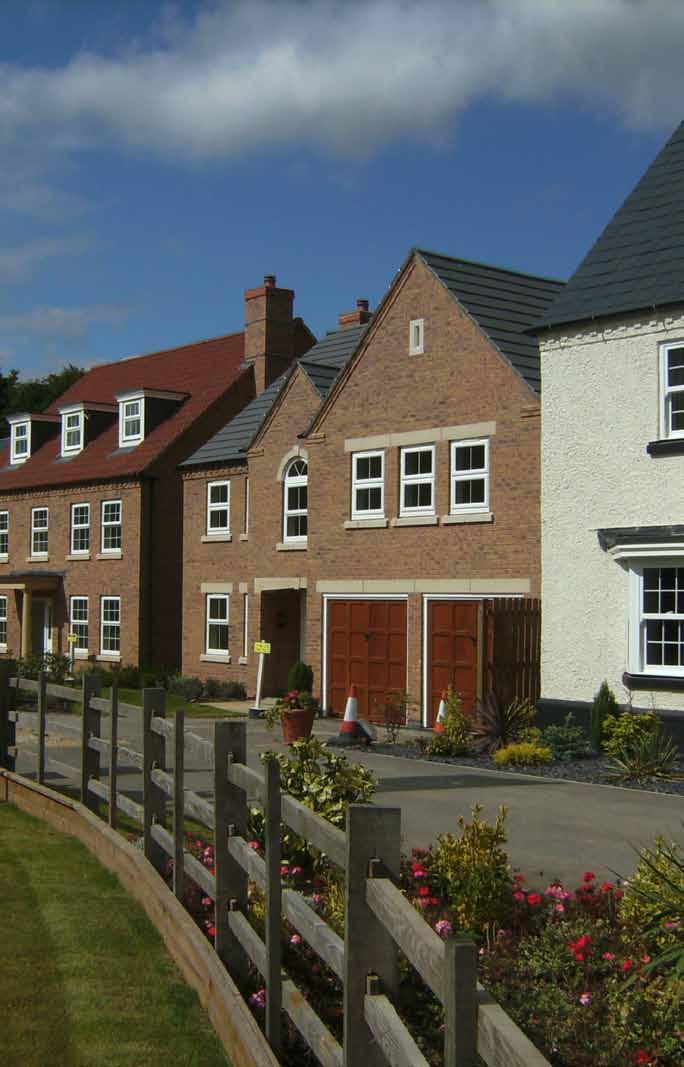
7 1 Background 1.1 Introduction The site forms the extent of the Northampton North Sustainable Urban Extension (SUE) as identified within the emerging West Northamptonshire Joint Core Strategy. The aim of this document is to provide a summary of technical studies and consultation work carried out to date and also to demonstrate that the proposals going forward will be suitable, viable and deliverable in accordance with the NPPF The development team have maintained a continuous dialogue with the West Northamptonshire Joint Planning Unit (JPU) and have attended monthly JPU meetings for over three years to progress the evolution of the SUE. Top: View along The Avenue. Bottom: Signage showing distances to local areas. Barratt developments
8
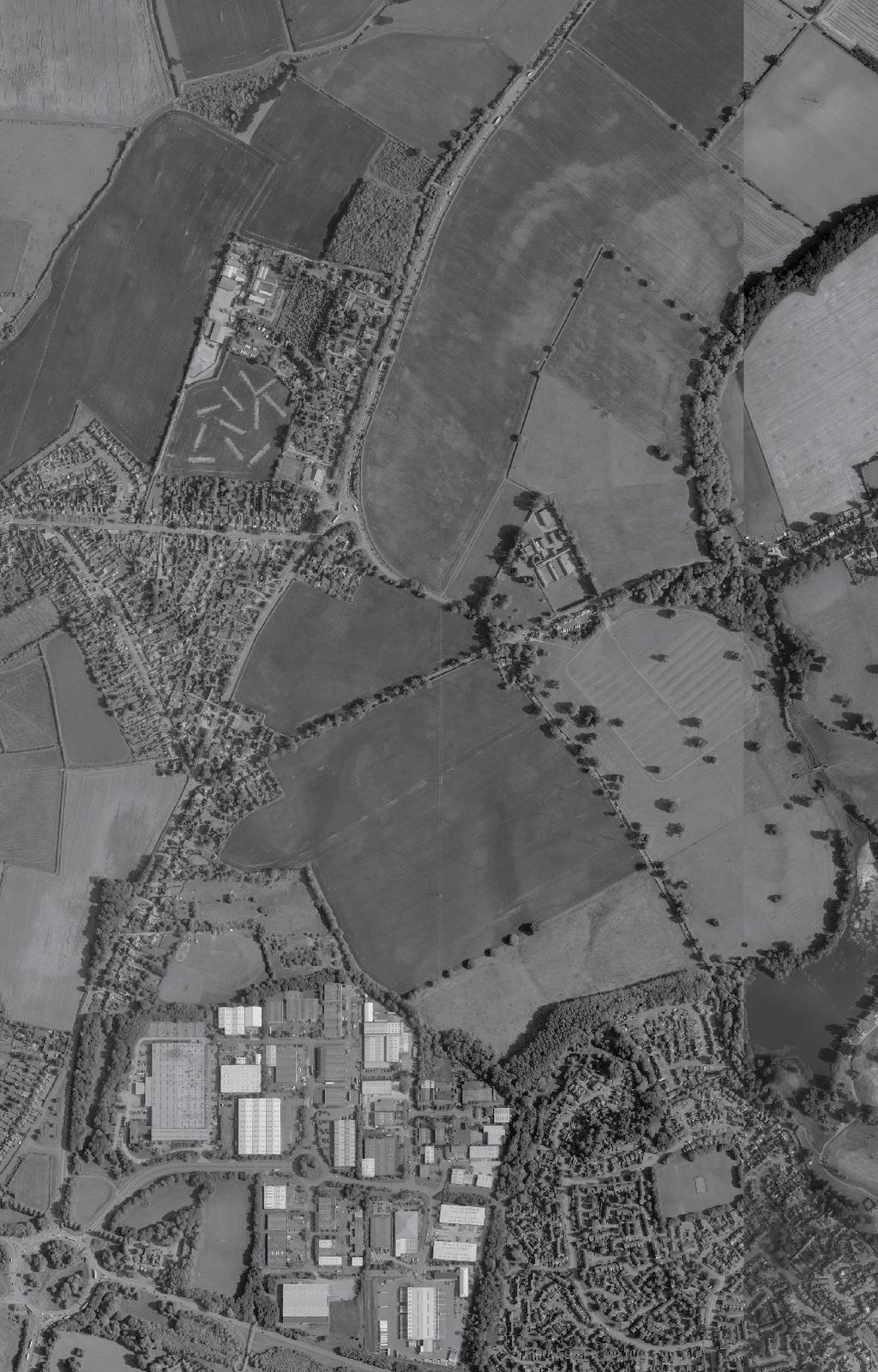
9 2 2.1 The Site Site Location The site lies to the north of the Northampton urban area and comprises land running along the eastern side of to the A43. The site is generally bounded by Round Spinney Industrial Estate and Coleman Leys to the south, the A43 to the west, a field boundary hedgerow to the north and by Billing Brook, Sywell Road and Billing Lane to the east The land is largely agricultural arable land with some paddock land to the south. The topography of the site to the south and north east slopes away towards the edges of the site. There are areas of existing trees mainly along the edges of the site (including Cowpasture Spinney - a Local Wildlife Site and Coleman Leys - a Potential Wildlife Site) and some hedgerows that pass through parts of the site. Trees protected by Tree Preservation Order are present along The Avenue and Overstone Road The Sustainable Urban Extension (SUE) is surrounded by five distinct character areas; Moulton village to the west; Overstone village to the east; Overstone Park adjacent to the east of the southern aspect of the site; open countryside to the north and Round Spinney Industrial Estate and Southfields residential area forming the outer urban edge of north Northampton to the south The greater part of the SUE is within Daventry District Council, however a small part of the SUE, running along the western side of Round Spinney Industrial Estate, is within, and owned by, Northampton Borough Council. Barratt developments

10 Image: Site Location Plan
11 3 3.1 The Proposal A New Sustainable Neighbourhood The proposal for the site is a residential lead sustainable urban extension comprising: 2000 dwellings at 30 dwellings per hectare; A new primary school; A new local and neighbourhood centre providing local shops, employment and community facilities; The development proposals are in accordance with the emerging Joint Core Strategy Policy N It is our aim to deliver a new section of dual carriageway road to form a realigned A43 as it approaches Moulton from the north, heading to Road Spinney Roundabout in the south. Development proposals are currently being worked up with Northamptonshire County Council. Significant areas of public open space, together with an informal parkland area; Improved public transport connections; Improved road linkages and connections. Barratt developments
12

13 4 4.1 Understanding the Site Site Analysis 4.2 Landscape The site comprises rolling arable farmland and is strongly influenced by the surrounding landscape, which encloses much of the site, particularly to the south of The Avenue The site lies along the Cowpasture Spinney to the east and Coleman Leys to the south, which provides a strong landscape edge to the site. The site is effectively split into two areas by the existing road network of The Avenue and Overstone Lane that are both treelined and give this area of the site a real sense of character and identity The surrounding road network consists of Billing Lane, which provides access to Overstone and Northampton. The existing A43 is the key arterial route that provides strategic connections from Northampton to Kettering and Wellingborough Moulton is located to the west of the site and Overstone to the east. These two villages are linked by Overstone Lane which is at the centre of the site, with the A43 providing a natural crossroads and intersection There are two saved policies in the Daventry Local Plan that cover different parts of the site area: Policy EN10 Green Wedges; and Policy EN11 Rural Access Area Only the very south-eastern part of the northern section of the site (northeast of Overstone Farm) is covered by Policy EN10. This is unlikely to present a constraint to development since most of the area covered by EN10 will remain largely undeveloped in the form of proposed green infrastructure The extent of Policy EN11 on the site runs from Overstone Lane in the north, southwards to the northern edge of the Round Spinney Industrial Estate and the residential area of Southfields Due to its location, the site retains many urban or urban fringe influences extending north across the site from Northampton. The Northampton Sensitivity and Green Infrastructure Strategy (March 2009) identified the area within which the site is located ( North-Eastern Quadrant ), as medium-high landscape and visual sensitivity overall, but with pockets of lower visual sensitivity in the vicinity of the site, including those northeast of Round Spinney, and north of Overstone. The landscape and visual appraisal acknowledged these points and it is considered that the site retains generally a low-medium landscape and visual sensitivity, particularly closer to the urban edge. Barratt developments

14 Constraints and Opportunities Plan


15 Constraints and opportunities A number of constraints and opportunities associated with the site have been identified, outlined below and illustrated on the constraints and opportunities plan opposite. Key issues include existing pylons, highways and vegetation. Constraints Existing tree groups and hedgerows along the site boundaries, particularly along Cowpasture Spinney and Coleman Leys. Existing pylons cross the site in a south-north direction. Existing boundaries to surrounding residential properties and employment uses. Existing public rights of way need to be integrated into the proposal. Careful consideration regarding the drainage strategy. Constrained local highway network. Opportunities To integrate with and contribute positively to the strategic green infrastructure network. Provide safe and convenient access into the site from the new A43 route. Provide a new local centre with supporting community facilities to serve the new development and the immediate surrounding area. Create a high quality development that integrates with the surrounding character and identity of the local villages. Create a new, positive rural edge to the north of Northampton. Barratt developments
16 Highways Traffic surveys have been undertaken across the site area and beyond in order to establish an accurate understanding of current traffic movements. The approach to the assessment has been agreed with Northamptonshire County Council (NCC), being the Local Highway Authority The Northampton Strategic Transport Model is being used to undertake the traffic modelling to understand accurately the level of traffic generated as a result of the development. Any impacts resulting for the development will be fully identified and assessed, with the necessary mitigation measures implemented The main physical highway mitigations works will consist of highway improvements and enhancements. These will be delivered in agreement with NCC and will include: Improvements and enhancement at Round Spinney Roundabout; and A new bypass through the development taking traffic away from the existing A Environmental and safety improvements/betterment will be delivered through: speed control measures; traffic calming; and public realm improvements on the local roads in the vicinity of the site the existing A43, The Avenue and Overstone Lane The scheme will also contribute to the wider A45 improvements and positive benefits will be gained from the investments that will be put into public transport Travel Demand Management proposals will aim to generate modal shift, i.e. getting people to stop using their car and use other modes, (bus, walking and cycling). As part of this, single occupancy car users will be targeted to reduce the number of vehicles on the existing network (by car clubs, incentivised schemes, etc). 4.5 A The development team have been working with Northamptonshire County Council and other key stakeholders for over four years. The county council has firm plans to carry out improvements to the existing A43 between Northampton and Kettering, with this being identified by NCC as one of its top three infrastructure schemes within the county It is considered that the Northampton North SUE is the catalyst for the delivery of this strategically important scheme and negotiations in respect of this are well advanced between NCC and the development team, with funding applications having now been submitted to central Government The development will provide significant financial contributions towards the new A43, Round Spinney Roundabout Improvements and towards public transport provision. Barratt Developments
17 Flood A preliminary assessment of flood risk and surface water drainage issues was commissioned in April The assessment identified the most likely source of flood risk as being that associated with existing watercourses, in particular the Billing Brook Billing Brook flood model data has been obtained from the Environment Agency and the scope of the Flood Risk Assessment has been agreed alongside the EA in order to define its approach and methodology Environment Agency Flood Zone data extends along the Billing Brook bounding the site. This data suggests that both the 1 in 100 year and 1 in 1000 year floodplains are confined to a relatively narrow corridor either side of the watercourse, such that the vast majority of the site area beyond the right bank of the brook lies outside the floodplain Sustainable Urban Drainage Systems (SuDS) will be employed across the development using; balancing ponds, swales, rainwater harvesting, etc. The SuDS proposals will create wider benefits and betterment in respect of biodiversity, habitat creation, visual improvements, quality amenities and health & wellbeing benefits Pollution control will be delivered and water quality improvements achieved. Water will be stored on-site (in the balancing ponds) during flood conditions, thus providing flood risk mitigation up and down stream and providing betterment over the current arrangement The flood mitigation (surface water storage) design solution will be undertaken for the 1:200 year storm event, plus a 30% allowance for climate change. Barratt developments
18 Utilities All existing services have been identified and these constraints mapped against the scheme proposals to ensure a deliverable solution. Primarily, these consist of high pressure gas mains and overhead power lines The 132kva overhead electricity line can be diverted and lowered below ground to match the proposed development layout The Local High Pressure gas main to the north of the site (outside the site boundary) has a protection zone of between 50m to 100m within which the type and extent of development is controlled The utility demands of the development have been calculated and the supply of services for the new development has been confirmed with the key Statutory Undertakers. 4.8 Minerals There is a Mineral Safeguard Area (MSA) designation across a section of the site in the northern parcel. The MSA is a designation that acknowledges the potential for a mineral resource within the ground, in this case sands and gravel The quality of the potential minerals to be extracted is a key consideration. Also of consideration for any MSA is the accessibility to the same minerals elsewhere There are substantial sand and gravel mineral reserves in Northamptonshire thereby the loss of 37.4ha is not significant. It is understood that the quality of this particular reserve is average thereby the cost of extracting such a small area of average quality is unlikely to be financially viable. Barratt Developments
19 Ecology Ecological survey work undertaken can be split into 3 main areas; a desktop study, habitat survey and faunal survey The initial Phase 1 habitat survey work was carried out in January and February 2009 with update visits undertaken in July and August Specific Phase 2 habitat survey work has been carried out in respect of the following areas: Bats; Badgers; Water Voles; In terms of protected species, no evidence to suggest any bats were roosting within the study area was recorded during the survey work undertaken. No evidence of water vole or otters either.thirteen Badger setts were recorded within and adjacent to the study area, two of which were identified as main setts Opportunities for ecological enhancements within the proposed development will be identified and these will be used to promote a net gain in biodiversity across the development. Otters; Breeding Birds In relation to the findings, there are no statutory nature conservation designations within the study area Two non-statutory ecological designations are located partly within the study area In terms of habitats, the majority of the study area is considered to be of low ecological value comprising arable farmland, with smaller areas of species poor, semi-improved/improved grassland, scrub and tall ruderal vegetation present. Some habitat/ features of moderate high local ecological value are present, mainly around the margins of the study area, such as the mature trees, woodlands and orchard. Barratt developments
20 Archaeology The site has been subject of extensive archaeological investigations, inclduing geophysical survey and trial trenching The findings reveal that there are no Scheduled Ancient Monuments, Registered Parks and Gardens or Registered Battlefields designated on the site or in its vicinity Two Grade II Listed buildings (Pytchley Gates and the Church of St Nicholas) occur nearby and their settings will need to be considered and respected Although Overstone Park is not a Registered Historic Park and Garden, the Northamptonshire Historic Landscape Character Assessment identifies the Park, with its deserted village of Overstone and garden remains, as an important historic landscape As a result of investigations carried out during the 1970 s the remains of a Roman settlement were excavated within the southern part of the main site. In addition, the desk-based assessment identified a Roman Settlement site and number of isolated sites which suggest late prehistoric and Medieval/Post-Medieval activity on parts of the main site Furthermore, the desk-based assessment also identified the remains of a windmill mound and ploughed-out ridge and furrow within the main site As a result of geophysical investigation followed by targeted trail trench evaluation, the remains of a small rural Romano-British settlement were found within the main part of the site and the northern part of the site. The settlement dates from the late 1st through to 4th Centuries, indicating that it was occupied for much of the Roman period. Tis does not require preservation in sites and will not prevent development. Barratt Developments
21 Landscape A Landscape and Visual Impact Appraisal has been carried out for the site and surrounding area The site supports intensive arable farming, thus landscape resources are generally limited to field boundaries Due to its location, the site retains many urban or urban fringe influences extending north across the site from Northampton The Landscape and Visual Impact Appraisal analyses concludes that the nature and scale of the proposals are likely to be acceptable on the basis of the character of the site in its context The conclusions in the Northampton Sensitivity and Green Infrastructure Study (March 2009), these being that the site and its wider context is generally of medium-high landscape and visual sensitivity, but with pockets of lower sensitivity in the vicinity of the site, are consistent with those of the landscape and visual assessment The masterplan for the site has been prepared in an integral fashion with the Landscape and Green Infrastructure (GI) Strategy. The Landscape and Visual Impact Appraisal identifies a number of opportunities in landscape and visual terms: Good visual containment; A strong relationship the central and southern sections of the site have with the existing urban edge of Northampton; Potential for extended links with the existing public right of way network and adjacent urban area; Habitat creation and biodiversity opportunities associated with existing resources e.g. Cowpasture Spinney, and potential new resources e.g. sustainable urban drainage structures; Potential for the creation of a very strong and memorable threshold or gateway features The proposed Landscape and Visual Mitigation and GI Strategy for the site is a direct and positive response to both the policy background and the constraints and opportunities offered by the site and its context. Barratt developments

22 Emerging Concept Masterplan
23 5 Concept Masterplan Overstone Leys will be a locally distinctive, sustainable and thriving new neighbourhood that is well integrated and connected to Northampton. It will provide a balanced mix of high quality housing together with local employment opportunities connected with the new local centre within a network of green infrastructure connecting existing areas of environmental value. It will consist of a vibrant residential neighbourhood with accessible local services and facilities. A primary school is located at the heart of the community, which provides a key landmark building for the centre of Overstone Leys and the surrounding villages. The scheme will also provide the catalyst to deliver a high priority road infrastructure scheme and significant betterment of public transport provision The Concept Masterplan Overstone Leys provides an exciting opportunity to deliver a sustainable, high quality mixed-use development that will contribute to delivering a comprehensive scheme, including a new living and working community which integrates housing, employment and other land uses reducing the need to travel by car. Economic role The new neighbourhood will include a new community hub to provide local employment to complement the easily accessible opportunities available in the local area. Social role Overstone Leys will support the creation of a vibrant and healthy community by supplying a range of housing, including affordable housing, and accessible local services to support health, social and cultural well-being. 5.2 A Sustainable Development Structure The Masterplan Concept has been heavily influenced by the views and thoughts of local representatives and stakeholders through a series of workshops that aim to capture the key themes and principles that begin to underpin the future proposals The masterplan concept aims to reinforce the sense of place by utilising the qualities of the landscape setting with the application of a series of sustainable structuring concepts to inform the design of future development. The key sustainable structuring concepts are as follows: Community Hub and Local Centre. Movement and Connections. Green Infrastructure. Character and Identity. Environmental role New development at Overstone Leys will protect and enhance the natural, built and historic environment by improving biodiversity and enhancing the character of the immediate context. Barratt developments


24 Consultation The development team has met with Overstone Parish Council and Moulton Parish Council and made presentations to Daventry District and Northampton Borough members Two Stakeholder Workshops were recently carried out on the 4th and 25th February 2013, a full day and half day session respectively Representatives from Overstone, Moulton and Sywell Parish Councils attended the events, as did representatives from Daventry District Council, Northampton Borough Council, Northamptonshire County Council, West Northamptonshire Joint Planning Unit, Highways Agency, Northamptonshire Police, Northamptonshire Fire and Rescue, the Environment Agency, Northamptonshire Wildlife Trust and Barratts, as well as local businesses, community groups and sports clubs. Each event was attended by approximately people. Event The first event comprised the following 4 workshop sessions: Workshop 1 Shaping a sustainable place (looking at creating a sense of identity and place, route of the A43 and the use of green infrastructure); Workshop 2 - Movement and connections (focus on local roads, walking, cycling and public transport and impacts on existing and new communities and connections between them); Workshop 3 Community - Social Infrastructure (thinking about provision for healthcare, education, community, recreation and leisure); Workshop 4 Capturing the benefits, guiding development (review of the previous sessions and setting out the key issues) Key individuals from each of the organisations were written to personally and invited to both sessions. Barratt Developments


25 25 Event The second event was aimed at feeding back how the views expressed during the first session were taken forward into the masterplan, as well as setting out areas that require further work. Copies of the developing concept masterplan were distributed amongst the tables The feedback from both workshops is currently being collated and will be made available at co.uk 5.4 The Way Forward The development team will be engaging with the wider public with a local exhibition planned for May This will involve extensive leaflet drops to the surrounding local communities All thoughts and suggestions will be considered carefully and used to help further shape development proposals on site. Evolution of masterplan Feedback from the various workshops held during both events was taken away and assessed in detail. Strong themes emerged from the feedback in relation to a need to create a new place with its own identity, whilst still respecting the distinctive characters of the surrounding existing communities. There was also a clear desire for strong cycle/footpath links between the new and existing communities, as well as an encouraging level of endorsement for the proposed route of the new stretch of A43. Feedback from the workshops will continue to be assessed in shaping the masterplan going forward. Barratt developments
26 26 Delivery6 6.1 Delivery Barratt Developments are presently working up a planning application for submission to Daventry District Council in July An Environmental Statement Screening and Scoping Request has been submitted and a Planning Performance Agreement will soon be entered into to deliver a decision by the end of It is thus anticipated that outline planning permission will be secured by the end of this year to enable development to commence towards the end of 2014 and first housing completions in the first quarter of The site will be made available to a number of house builders, not just Barratt/David Wilson Homes. In housing market terms, the location is an attractive part of the town and a build rate of dwellings per annum is certainly achievable. 6.2 Viability Barratt Developments have undertaken a number of background technical studies to fully understand the constraints and opportunities this development presents. From these studies the developer has a full understanding of the known abnormal development costs (such as off and on site highway works, foul drainage, SUDs, site servicing costs, ground conditions, removal of overhead power lines etc.) that need to be factored into the scheme. The net residual value of the development will be sufficient to ensure that the following is achieved: A commercially acceptable land receipt to the landowners; A significant contribution towards the provision of the new A43 link road; A planning obligation to deliver the necessary infrastructure improvements in accordance with CIL Regulation 122; and On-site affordable housing The development being promoted is a specific deliverable proposal that is financially viable and available now. 6.3 Infrastructure Barratt and NCC are working in collaboration to secure early delivery of the A43 link road through the scheme The design work for the A43 link has been commissioned and it is anticipated that a detailed application for the link road will be submitted with the outline planning application for the main scheme in July. Barratt Developments
27 7 Conclusions Conclusions This short summary report confirms: The site is being promoted by a national house builder; The site can deliver the policy N3 requirements; The scheme proposals are being worked up in consultation with the local community and representatives, together with the JPU and key stakeholders; A scheme for the early delivery of a new dual carriageway section of the A43 through the development site is at an advanced stage with NCC and funding is being secured for this; There are no technical impediments to the delivery of the proposed development; 2,000 homes can be delivered in the plan period. Barratt developments
28 Barratt Barratt House Cartwright Way Forest Business Park Bardon Hill Coalville Leicestershire LE67 1UF
Kibworth Harcourt. Introduction. Introduction
 Introduction Introduction Welcome to this public exhibition on the proposals for the delivery of new homes on land at The Kibworths. The purpose of today s exhibition is to give you the opportunity to
Statement of Community Involvement LAND OFF SOUTHDOWN ROAD HORNDEAN, HAMPSHIRE
 LAND OFF SOUTHDOWN ROAD HORNDEAN, HAMPSHIRE CONTENTS Page 1. Introduction 3 2. Pre-application Discussions 4 3. The Consultation Process 5 4. Consultation Feedback 7 5. Responses to Consultation Feedback
WELCOME. Land North of STEVENAGE. We would like to thank you for attending our public exhibition today.
 WELCOME We would like to thank you for attending our public exhibition today. The purpose of this event is to share our proposals and hear your thoughts on our ideas. Members of the project team are on
Welcome to our exhibition
 Welcome to our exhibition The Homes & Communities Agency (HCA) welcomes you to this public exhibition explaining our proposals for the redevelopment of the former Lea Castle Hospital site. About the Homes
Welcome to our Public Consultation
 About our development This exhibition gives you the chance to view and comment on our emerging plans for a proposed residential development located on land to the West of Alwyn Road, Rugby. Welcome to
Welcome to our public exhibition
 About our development Welcome to our public exhibition This exhibition gives you the chance to view and comment on our proposals for a new residential development of 165 high-quality homes, along with
Neighbourhood Planning Site Assessment Pro-forma and Guide Version 2
 Neighbourhood Planning Site Assessment Pro-forma and Guide Version 2 September 2014 Site HNP 006 Land East of Stanbridge Road and North of Lower Road 1. Background information Site location and use Site
INTRODUCTION NORTH HEYBRIDGE GARDEN SUBURB
 INTRODUCTION This event is being hosted by the promoters of the proposed North Heybridge Garden Suburb who are working with Maldon District Council and other key stakeholders on the preparation of a comprehensive
About 10% of the Borough's population lives in the seven rural parishes. Population figures from the 1991 census are given below:-
 8. THE DISTRICT VILLAGES 8.1 Population About 10% of the Borough's population lives in the seven rural parishes. Population figures from the 1991 census are given below:- Village No. of Persons Cottingham
WELCOME GYPSY LANE. Wider Site Location plan. Proposals for the development of LAND OFF FOXLYDIATE LANE WEBHEATH. Proposals for the development of
 WELCOME The developers are preparing an outline planning application for a residential led development and need the community s views in order to develop the proposals further WHAT IS PROPOSED? A high
Public Consultation. Land at Monks Farm, North Grove. Welcome
 Welcome Welcome to our public exhibition for development on Land at Monks Farm, orth Grove. Gallagher Estates and Gleeson Strategic Land are preparing an outline planning application for new homes, open
Land at Rampton Road. Cottenham
 Land at Rampton Road Cottenham Introduction TEP is preparing an outline planning application for 54 dwellings on 6.9 hectares of land adjacent to Rampton Road, Cottenham on behalf of the owners Cambridgeshire
SPG 1. * the northern and western sections which are open fields used for pasture and grazing;
 SPG 1 1.0 INTRODUCTION This development brief is based on the allocation of the Priors Hall site for employment and countryside recreational purposes in the Corby Borough Local Plan. The brief is intended
Grantham Southern Quadrant Link Road Environmental Statement
 Grantham Southern Quadrant Link Road Environmental Statement Non Technical Summary Introduction Lincolnshire County Council (LCC) is submitting a planning application for the proposed implementation of
DESIGN & ACCESS STATEMENT
 DESIGN & ACCESS STATEMENT January 2016 Contents Introduction section 1 Section 1 - Introduction Section 2 - Assessment Section 3 - Involvement Section 4 - Evaluation Section 5 - Design Section 6 - Layout
CENTRAL BEDFORDSHIRE COMMITTED TO WORKING TOGETHER WITH LOCAL COMMUNITIES
 WELCOME Thank you for coming to our consultation event to find out more about our emerging proposals for Hayfield Park, a residential development jointly promoted by the Hayfield Consortium: Martin Grant
WELCOME. Welcome and thank you for visiting today.
 WELCOME Welcome and thank you for visiting today. Bellway Homes Ltd (Yorkshire) are preparing a reserved matters planning application for a residential development of 293 homes at land North of Yew Tree
WELCOME TO THE NEW WILTON PARK
 WELCOME TO THE NEW WILTON PARK VISION HISTORY OF WILTON PARK TOWARDS A PLANNING APPLICATION Our objective is to create a truly outstanding environment at Wilton Park. At the heart of our proposals is a
Newcourt Masterplan. November Exeter Local Development Framework
 Newcourt Masterplan November 2010 Exeter Local Development Framework Background The Exeter Core Strategy Proposed Submission sets out the vision, objectives and strategy for the development of Exeter up
Welcome to our public exhibition
 About Our Scheme Welcome to our public exhibition This exhibition gives you the chance to view and comment upon our emerging proposals for a new residential development of 68 new homes on the site of the
WHITELEY TOWN COUNCIL NORTH WHITELEY DEVELOPMENT SEPTEMBER 2014
 WHITELEY TOWN COUNCIL NORTH WHITELEY DEVELOPMENT SEPTEMBER 2014 Dear Resident This Special Edition of the Whiteley Voice which has been prepared in conjunction with the North Whiteley Consortium is to
University Park, Worcester Non Technical Summary December 2011
 University Park, Worcester Non Technical Summary December 2011 Introduction UW Wrenbridge LLP, a Joint Venture Company of the University of Worcester and Wrenbridge Land Ltd (the Applicants ) intend to
Development of land adjacent to Braggs Farm Lane and Rumbush Lane, Dickens Heath. Welcome. Today s exhibition. The proposal site
 Welcome Welcome to this event to discuss the development of land adjacent to Braggs Farm Lane. is currently in the preliminary stages of designing proposals to sensitively develop this site with high-quality
WELCOME. North East Haverhill. The Planning Process
 WELCOME North East The site to the North East of, known as Great Wilsey Park, is identified by St Edmundsbury Borough Council in its Core Strategy as capable of delivering a Sustainable Urban Extension.
Public Consultation 23 January Peel Hall, Warrington Board 1. A message from Satnam... Site history...
 Board 1 A message from Satnam... Thank you for attending today s public consultation about proposals to develop a new residential neighbourhood at. The display boards show why the development is needed
The Fairfield Partnership Vision for North-East Elsenham
 The Fairfield Partnership Vision for North-East Elsenham August 2009 Frequently Asked Questions Who is The Fairfield Partnership? The Fairfield Partnership is a joint venture between Marchfield Developments
WELCOME LAND EAST OF TYE LANE, WALBERTON. Above all, it s about people
 WELCOME Welcome to this public exhibition relating to our draft residential proposals for the land east of Tye Lane, Walberton. Today gives you the opportunity to have an active role in shaping these ideas
BREEDON NORTHERN LIMITED
 Non Technical Summary CONTENTS 1 INTRODUCTION... 1 2 SITE DESCRIPTION... 1 3 DESCRIPTION OF THE DEVELOPMENT... 6 4 NEED FOR THE DEVELOPMENT... 8 5 KEY ISSUES CONSIDERED IN THE ENVIRONMENTAL IMPACT ASSESSMENT...
Welcome to our exhibition
 Welcome to our exhibition housing development A46 Wildmoor Alcester Road Canal Quarter A422 Town Centre housing development Warwickshire-based IM Properties, one of the UK s largest privately owned property
Proposed S.U.E. Drayton Fields Industrial Estate. Royal Oak Industrial Estate. Daventry Town Centre. Long Marsh Industrial Estate.
 local context and amenities Existing Local Facilities Nearby Education Facilities in Daventry Local Retail Welton C of E Primary School Well Lane, Welton. This is a mixed sex rural primary school and has
Site ref: AS06 Site Name or Address: Murreys Court, Agates Lane
 Site ref: AS06 Site Name or Address: Murreys Court, Agates Lane Proposed Land Use: Total Site Area (Ha): Housing 1.85 Ha Description: It is understood that the owner has no plans to dispose of the site
SITE ASSESSMENT CHECKLIST
 1. Site Details a. What is the site s name/reference? SITE ASSESSMENT CHECKLIST CR3NPWHY 3007 Gasometer Site Godstone Road CR3 0EG b. Where is the site located? Wyhteleafe; Godstone Road. Urban category1
Land at BROOK STREET PROPERTIES TENCREEK FARM, LISKEARD. Environmental Statement: Non-Technical Summary
 BROOK STREET PROPERTIES TENCREEK FARM, LISKEARD Land at Environmental Statement: Non-Technical Summary Introduction Brook Street Properties is applying to Cornwall Council for outline planning permission
The journey so far. The new masterplan for Dargavel Village
 The journey so far Our vision for Dargavel Village began over ten years ago when the original masterplan for transforming the former Royal Ordnance Factory site into a thriving community was established.
Settlement Boundaries Methodology North Northumberland Coast Neighbourhood Plan (August 2016)
") Introduction This background paper sets out a methodology for the definition of settlement boundaries in the North Northumberland Coast Neighbourhood Plan. The neighbourhood plan is planning positively
Introduction This background paper sets out a methodology for the definition of settlement boundaries in the North Northumberland Coast Neighbourhood Plan. The neighbourhood plan is planning positively
Welcome to our public exhibition
 About our scheme Welcome to our public exhibition Taylor Wimpey East Anglia intends to submit a detailed planning application for a new residential development of 39 high-quality homes at the B&M Concrete
DESIGN & ACCESS STATEMENT
 DESIGN & ACCESS STATEMENT Land to the South East of the A495, Bronington Erection of 31 Dwellings (27 dwellings and 4 bungalows including 4 Affordable Dwellings), Realignment and Improvements to A495 (including
LEEDS SITE ALLOCATIONS PLAN MATTER 3 GREEN BELT KCS DEVELOPMENT AUGUST 2017
 LEEDS SITE ALLOCATIONS PLAN MATTER 3 GREEN BELT KCS DEVELOPMENT AUGUST 2017 Smith Limited Suite 9C Joseph s Well Hanover Walk Leeds LS3 1AB T: 0113 2431919 F: 0113 2422198 E: planning@peacockandsmith.co.uk
Welcome. Site/11/04. Site/11/03. Proposed Site. 11,400 new homes needed in east Cambs
 Welcome Welcome to our consultation on our proposals for new homes on land north east of Soham Road, Fordham. Members of the project team are available to answer any questions you have and listen to feedback.
Replacement Golf Course Facilities and Residential Development, Churston. Environmental Statement Non-Technical Summary
 Replacement Golf Course Facilities and Residential Development, Churston Environmental Statement Non-Technical Summary July 2011 Reproduced from the Ordnance Survey s map with the permission of the Controller
NON-TECHNICAL SUMMARY
 Proposed Sand and Gravel Extraction and Associated Processing Operations with Restoration to a Mixture of Agriculture and Nature Conservation including Areas of Shallow Water at Hedgeley, Northumberland
What do you like about South Marston?
 What do you like about South Marston? What you have said so far: Strong and separate identity, distinct from Swindon Village character (Church, School, Green and Hall) Surrounding working countryside and
Welcome to our public consultation
 About our development Welcome to our public consultation This exhibition gives you the chance to view and comment on our proposals for a residential development of up to 187 high-quality homes, along with
HARDWICK GREEN, King s Lynn. Welcome to our Exhibition. What are your views? Introduction to the site and proposals. About us
 HARDWICK GREE, King s Lynn Welcome to our Exhibition Welcome to our exhibition, which is being held to provide you with the opportunity to understand and comment upon our proposals for new residential
Welcome. Proposals for land at Smug Oak Lane BRICKET WOOD
 Proposals for land at Smug Oak Lane BRICKET WOOD Previous Linden Homes and Wates Developments scheme Welcome Welcome to Linden Homes and Wates Developments public exhibition. Working together as joint
Neighbourhood Planning Local Green Spaces
 Neighbourhood Planning Local Green Spaces Introduction... 2 1. Why green space is important... 4 2. Neighbourhood plans and green space... 6 3. Evidence... 8 Statutory designations... 9 Green space audit...
The proposals presented in September drew a large number of comments and feedback and have been grouped together as follows:
 Appendix A Stakeholder presentation + powerpoint slides Planning Context and Emerging Proposals presentation Nick Tyrrell, Alder King, Planning Consultants Alder King began by setting the site context
Chapter 2: OUTLINE PLANNING APPLICATION PROPOSALS. A New Garden Neighbourhood Matford Barton 17
 Chapter 2: OUTLINE PLANNING APPLICATION PROPOSALS A New Garden Neighbourhood Matford Barton 17 2.1. SUMMARY AND STATUS OF THE PROPOSALS 2.1.1. The parameter plans and associated wording in this chapter
Wiltshire Council s Core Strategy
 HAWKE Wiltshire Council s Core Strategy 2006-2026 As part of its Core Strategy (master plan), Wiltshire Council needs to find areas to develop for employment purposes up to 2026. This land was first suggested
1.0 INTRODUCTION. Brantham Industrial Area Regeneration - Factory Lane - Brantham
 1.0 INTRODUCTION Welcome to this exhibition of our proposals for the regeneration of the Brantham Industrial Area located off Factory Lane in Brantham. This presentation will give you an opportunity to
Welcome to this exhibition which shows emerging ideas for land owned by University of Bristol at Long Ashton.
 1 Introduction Welcome to this exhibition which shows emerging ideas for land owned by University of Bristol at Long Ashton. The University of Bristol owns a 170 acre site south of Long Ashton village
Derry City and Strabane District Council Planning Committee Report. Amended layout from approval A/2004/0462/F with reduction from 166 units
 Derry City and Strabane District Council Planning Committee Report COMMITTEE DATE: 1 st February 2017 APPLICATION No: APPLICATION TYPE: PROPOSAL: LOCATION: APPLICANT: AGENT: Full Planning application Amended
Great Easton Neighbourhood Plan Statement of Basic Conditions
 Great Easton Neighbourhood Plan 2017-2031 Statement of Basic Conditions OCTOBER 2016 GREAT EASTON PARISH COUNCIL Contents 1.0 Introduction....Page 2 2.0 Summary of Submission Documents and Supporting Evidence..
8.0 Design and Form of Development 43/
 42/ 8.0 Design and Form of Development 43/ Rothwells Farm, Golborne/ Development Statement Figure 7. Site Constraints Key 44/ Site Boundary 360 Bus Route/Stops Existing Trees Underground Water Pipe Sensitive
A VISION FOR BLAIRGOWRIE
 Welcome to the Westpark Partnership and Lidl UK GmbH Community Presentation. The purpose of this presentation is for you to view and comment upon the revised and updated proposals for the allocated development
Amy Burbidge North Northants Joint Planning and Delivery Unit Tresham Garden Village
 Amy Burbidge North Northants Joint Planning and Delivery Unit Tresham Garden Village Location Location Background Garden Village promoted through preparation of Joint Core Strategy ENC supportive, others
Thank you for sparing the time to visit our exhibition and to provide us with your feedback on our proposals displayed here today.
 WELCOME Aerial image of the application site in context Thank you for sparing the time to visit our exhibition and to provide us with your feedback on our proposals displayed here today. Plymouth City
Rempstone Extension - East Leake 2014
 Overall Restoration of East Leake Quarry Sand Martin Face Southern Agricultural Corridor Wetland Ponds/Conservation Corridor following Sheepwash Brook Reinstated Bridleway/Footpaths Southern Agricultural
Colchester Northern Gateway Master Plan Vision Review Draft. July 2016
 Colchester Northern Gateway Master Plan Vision Review Draft July 2016 Contents Introduction 4 Context 8 Purpose of the Report 8 Strategic Position 9 Overview of the Process 11 2012 Master Plan Vision 12
Haydock Point. Welcome
 Welcome Peel Logistics Property, alongside Peel Land and Property, is preparing a planning application for Haydock Point, a high-quality logistics park east of Haydock. The purpose of this exhibition is
Carterton Construction Ltd is bringing forward plans for up to 85 new family homes and extra care facilities on land east of Burford.
 Welcome Carterton Construction Ltd is bringing forward plans for up to 85 new family homes and extra care facilities on land east of. We are at the early stages of designing our proposals and have a number
DUNSFOLD NEIGHBOURHOOD PLAN Site Selection Policies
 DUNSFOLD NEIGHBOURHOOD PLAN Site Selection Policies The criteria for assessing sites for future housing and business development in Dunsfold are set out below. (Development criteria, covering what it is
Wyvern Park Skipton Environmental Statement. Non-technical Summary - April 2015
 Wyvern Park Skipton Environmental Statement Non-technical Summary - April 2015 BWB Consulting Ltd Whitehall Waterfront 2 Riverside Way Leeds LS1 4EH Telephone: +44(0)113 233 8000 Copyright This Report
LONGDEN VILLAGE DEVELOPMENT STATEMENT
 LONGDEN VILLAGE DEVELOPMENT STATEMENT 2017-2027 1 Longden Development Statement 2017-2027 15/01/18 1. Background 1.1 Longden Village Longden village is a very rural and traditional community first mentioned
Toddington Central Bedfordshire Stage 3 Green Belt Study December 2017
 Toddington Central Bedfordshire Stage 3 Green Belt Study December 2017 Site: ALP086 - Middle Lakes, Toddington Site size (ha): 2.83 Site: ALP086 - Middle Lakes, Toddington Site size (ha): 2.83 Site description
Key Principles. 290 Phasing Principles and Programme
 4 Phasing principles and programme 4c The aims of the phasing strategy are to satisfy planning policy requirements and create a sustainable, strong and healthy new community where, from the outset, people
Droitwich Spa 6. Reasoned Justification
 87 Droitwich Spa 6 Reasoned Justification 6.1 Droitwich Spa is identified in the settlement hierarchy (Policy SWDP1) as a main town being the largest settlement in Wychavon District with an estimated population
Environmental and Landscape Mapping
 Environmental and Landscape Mapping In support of the Calveley Neighbourhood Plan November 2016 Project Name and Number: Calveley Neighbourhood Plan 16-025 Document Name and Revision: Environmental and
Frequently Asked Questions
 1. Where is Aylesbury Woodlands? Frequently Asked Questions Aylesbury Woodlands lies to the east of Aylesbury. It is bounded to the south by the A41. To the north is the Aylesbury Arm of the Grand Union
Wallingford Neighbourhood Plan
 Wallingford Neighbourhood Plan Introduction What is neighbourhood planning? Neighbourhood planning was introduced by the Localism Act 2011 to give local people more influence over how development comes
Elderberry Walk. Developer HAB Housing
 Case studies Elderberry Walk Developer HAB Housing Development of 161 new homes on the former Dunmail Primary School site, focused around a central green street, with retained trees, new multifunctional
ROCHFORD LOCAL DEVELOPMENT FRAMEWORK: Sustainability Appraisal/ Strategic Environmental Assessment. Rochford Core Strategy Preferred Options Document
 ROCHFORD LOCAL DEVELOPMENT FRAMEWORK: Sustainability Appraisal/ Strategic Environmental Assessment Non Technical Summary Rochford Core Strategy Preferred Options Document October 2008 SUSTAINABILITY APPRAISAL
Rochford District Council Allocations Development Plan Document: Discussion and Consultation Document Sustainability Appraisal
 Option SWH1 Balanced Communities Option SWH1 1 To ensure the delivery of high quality sustainable communities where people want to live and work Will it ensure the phasing of infrastructure, including
South Worcestershire Development Plan. South Worcestershire Design Guide Supplementary Planning Document
 South Worcestershire Development Plan South Worcestershire Design Guide Supplementary Planning Document Statement of Consultation: Early Engagement Scoping Paper February 2017 1. Introduction 1.1 This
Test Valley Borough Council. Strategic Housing Land Availability Assessment (SHLAA)
") Test Valley Borough Council Strategic Land Assessment (SHLAA) Appendix 2 Southern Test Valley Sites Where a Change in Policy is Required for Residential Development Final Version as at 1 st April 2014
Test Valley Borough Council Strategic Land Assessment (SHLAA) Appendix 2 Southern Test Valley Sites Where a Change in Policy is Required for Residential Development Final Version as at 1 st April 2014
ABOUT CALA HOMES CALA HOMES
 WELCOME Welcome to this public consultation event for our proposed development on land to the east of Salisbury Road, in Hungerford. Thank you for taking the time to come along today. Homes and Wates Developments
SITE ASSESSMENT CHECKLIST
 1. Site Details a. What is the site s name/reference? CR3 FORUM NEIGHBOURHOOD PLAN SITE ASSESSMENT CHECKLIST CR3NPCOH3016 Douglas Brunton Centre Park Rd b. Where is the site located? Caterham Hill urban
SOUTH WOKINGHAM STRATEGIC DEVELOPMENT LOCATION PUBLIC CONSULTATION
 01 WELCOME Croudace Homes, Gleeson Strategic Land, Kier Ventures, Lightwood Strategic and Miller Homes are delighted to welcome you to this public exhibition. Proposals for the site have been developing
LAND NORTH OF NETHERHOUSE COPSE, FLEET
 REPORT N O 70020067 LAND NORTH OF NETHERHOUSE COPSE, FLEET ENVIRONMENTAL STATEMENT VOLUME 3:NON-TECHNICAL SUMMARY OF THE ENVIRONMENTAL STATEMENT PUBLIC JUNE 2016 LAND NORTH OF NETHERHOUSE COPSE, FLEET
Plumpton Neighbourhood Development Plan Revised Pre Submission Document - Regulation 14 Consultation
 REPRESENTATIONS... Plumpton Parish Council Plumpton Neighbourhood Development Plan Revised Pre Submission Document - Regulation 14 Consultation Representations submitted on behalf of: Cala Homes (South
Linden Homes Proposals for land off Ringwood Road, Verwood
 Welcome Welcome to Linden Homes first public exhibition displaying proposals for new homes on land off Ringwood Road in Verwood. Award-winning house builder Linden Homes, part of the Galliford Try Group,
Hodgson s Gate. Welcome. Who we are. Hodgson s Gate Developments. Thank you for taking time to attend today s event.
 Welcome Thank you for taking time to attend today s event. is promoting land off Hodgson s Lane at, Sherburn-in-Elmet for a sustainable and high quality development. We are currently preparing an application
Schedule of Planning Applications Committee Date: 23 May Reference: 06/17/0726/F Parish: Hemsby Officer: Mr J Beck Expiry Date:
 Schedule of Planning Applications Committee Date: 23 May 2018 Reference: 06/17/0726/F Parish: Hemsby Officer: Mr J Beck Expiry Date: 22-05-2018 Applicant: Proposal: Site: Mr Gillett Change of use to the
SOUTH EAST LINCOLNSHIRE LOCAL PLAN: HOUSING PAPER DONINGTON (JUNE 2016)
") SOUTH EAST LINCOLNSHIRE LOCAL PLAN: HOUSING PAPER DONINGTON (JUNE 2016) 1 DONINGTON S PLACE IN THE SPATIAL STRATEGY 1.1 Policy 2 of the South East Lincolnshire Local Plan 2011-2036 Draft for Public Consultation
SOUTH EAST LINCOLNSHIRE LOCAL PLAN: HOUSING PAPER DONINGTON (JUNE 2016) 1 DONINGTON S PLACE IN THE SPATIAL STRATEGY 1.1 Policy 2 of the South East Lincolnshire Local Plan 2011-2036 Draft for Public Consultation
Slough International Freight Exchange Proposals, Colnbrook+
 Welcome Welcome to this exhibition, which is being held in connection with our proposals for a new freight exchange facility on land to the north of the A4. Please take this opportunity to look at the
ENVIRONMENTAL AND LANDSCAPE MAPPING
 APPENDIX IV : Environmental and Landscape Mapping ENVIRONMENTAL AND LANDSCAPE MAPPING Calveley Neighbourhood Plan November 2016 ENVIRONMENTAL AND LANDSCAPE MAPPING Calveley Neighbourhood Plan Calveley
Planning and Sustainability Statement
 Land adjacent to Manor Farm, Catterick Village Pallett Hill Sand and Gravel Co Ltd Proposed 10 new dwellings, (6 No market dwellings and 4 No affordable dwellings) with access, associated car parking and
The analysis of key visual characteristics and attributes that contribute to variations in the
 15.0 CHIGWELL/CHIGWELL ROW 15.1 Overview 15.1.1 Chigwell and Chigwell Row settlements are situated in the south of Epping Forest District, to the south of Abridge and southwest of Stapleford Abbotts. Both
ABBEY MANOR GROUP/SAINSBURY S SUPERMARKETS LTD
 ABBEY MANOR GROUP/SAINSBURY S SUPERMARKETS LTD Mixed Use Development including Business Park and Foodstore Land at Bunford Park, Bunford Lane, Yeovil Environmental Statement: Non-Technical Report June
Oxford Green Belt Study. Summary of Final Report Prepared by LUC October 2015
 Oxford Green Belt Study Summary of Final Report Prepared by LUC October 2015 Project Title: Oxford Green Belt Study Client: Oxfordshire County Council Version Date Version Details Prepared by Checked by
Land at Fiddington Hill Nursery, Market Lavington
 Land at Fiddington Hill Nursery, Market Lavington Briefing Report for Market Lavington Parish Council Persimmon Homes (Wessex) April 2016 Background This brief report has been prepared following the Market
Land Use Amendment in Southwood (Ward 11) at and Elbow Drive SW, LOC
 at and Elbow Drive SW, LOC") 2018 November 15 Page 1 of 10 EXECUTIVE SUMMARY This land use amendment application was submitted by Rick Balbi Architect on 2017 August 31 on behalf of Sable Developments Ltd, and with authorization from
2018 November 15 Page 1 of 10 EXECUTIVE SUMMARY This land use amendment application was submitted by Rick Balbi Architect on 2017 August 31 on behalf of Sable Developments Ltd, and with authorization from
Joint Core Strategy Rushden Sustainable Urban Extension
 Date Page 1 of 18 Report Originator Title Planning Manager Joint Core Strategy Rushden Sustainable Urban Extension 1. PURPOSE OF REPORT 1.1 To consider representations received on the emerging Joint Core
UTT/16/1466/DFO GREAT DUNMOW MAJOR
 UTT/16/1466/DFO GREAT DUNMOW MAJOR PROPOSAL: LOCATION: APPLICANT: AGENT: Reserved matters approval for the accesses to the site and principal roads within the site including spine road following outline
Blandford Forum Town Council, Blandford St Mary Parish Council and Bryanston Parish Council
 Blandford Forum Town Council, Blandford St Mary Parish Council and Bryanston Parish Council Blandford + Neighbourhood Plan 2 Pre-Submission Plan Consultation (November 2018) Representations submitted on
Copyright Nigel Deeley and licensed for reuse under this Creative Commons Licence
 1 Copyright Nigel Deeley and licensed for reuse under this Creative Commons Licence Prepared by the Neighbourhood Plan Steering Group on behalf of Garway Parish Council with assistance from 2 Table of
Thornton Road, Pickering Environmental Statement Non-Technical Summary. January 2016
 Thornton Road, Pickering Environmental Statement Non-Technical Summary January 2016 EIA Quality This Environmental Statement, and the Environmental Impact Assessment (EIA) carried out to identify the significant
North Northamptonshire Joint Core Strategy Consultation on Strategic Housing and Employment Sites
 North Northamptonshire Joint Core Strategy 2011 2031 Consultation on Strategic Housing and Employment Sites August 2013 1.0 The purpose of the consultation 1.1 The Joint Core Strategy (JCS) will identify
Response by The Dartington Hall Trust
 Consultation Response by The Dartington Hall Trust Site Reference: SH_39_02_08/13 Contents Introduction 1 Site Description 2 Development Proposal and Context 3 Site Technical Assessment 4 Planning Policy
Site Assessment Technical Document Appendix A: Glossary
 Central Bedfordshire Council www.centralbedfordshire.gov.uk Site Assessment Technical Document Appendix A: Glossary July 2017 1.1.11-1 - ii Appendix A: Glossary Term Agricultural Land Classification AONB