McCowan Precinct Plan Study Final Report
|
|
|
- Merryl York
- 5 years ago
- Views:
Transcription
 began a study of an area within the Scarborough Centre, identified as the")
1 STAFF REPORT ACTION REQUIRED McCowan Precinct Plan Study Final Report Date: May 2, 2014 To: From: Wards: Reference Number: Scarborough Community Council Director, Community Planning, Scarborough District Ward 38 Scarborough Centre EPS 00 TM SUMMARY In September, 2011, City Planning (Scarborough District) began a study of an area within the Scarborough Centre, identified as the McCowan Precinct. The purpose of this Study is to develop a "Precinct Plan" (Neighbourhood Plan) for the McCowan Precinct (see Attachment No. 1) that would further articulate the policies of the Toronto Official Plan (including the Scarborough Centre Secondary Plan) and develop a framework to guide future growth and development of the McCowan Precinct, one of four Precincts of the Scarborough Centre. The McCowan Precinct Plan Study was undertaken with the assistance of area residents, landowners, business owners, Ward 37 & 38 Councillors, City Divisions and interested persons who formed "Working Groups" to assist in the development of the Precinct Plan. The Study has now been completed. The purpose of this report is to provide an overview of the study components, the consultation process, and the findings and recommendations of the Study, including future analysis/studies to be undertaken in relation to the McCowan Precinct and the surrounding areas. This report also provides an Staff report for action Final Report McCowan Precinct Plan Study 1
2 overview of the implementation plan for the McCowan Precinct Plan Study which includes: i) an Official Plan Amendment (OPA No. 242 Attachment No. 2 to this report) for Council's consideration that would add Site and Area Specific Policies for the McCowan Precinct to the Official Plan and ii) Urban Design Guidelines (including a Conceptual Master Plan) for the McCowan Precinct (Attachment Nos. 3 to 4B to this report) for Council's consideration. The City-initiated amendment (OPA No. 242) is subject to the new provisions of the Planning Act and the City of Toronto Act, RECOMMENDATIONS The City Planning Division recommends that: 1. City Council amend the Official Plan, substantially in accordance with the draft Official Plan Amendment attached as Attachment No. 2 to this report dated May 2, 2014 from the Director, Community Planning, Scarborough District. 2. City Council adopt "The McCowan Precinct Urban Design Guidelines", including the "McCowan Conceptual Master Plan" attached as Attachment Nos. 3 to 4B to this report dated May 2, 2014 from the Director, Community Planning, Scarborough District. 3. City Council direct staff to use the "McCowan Precinct Urban Design Guidelines, including the McCowan Conceptual Master Plan" in the evaluation of all new and current development proposals and public initiatives. 4. City Council direct the Chief Planner and Executive Director of City Planning to undertake, in consultation with the General Manager Transportation Services and other City Divisions, a Scarborough Centre Transportation Master Plan Study to examine the existing and planned transportation network within the Scarborough Centre and surrounding area. 5. City Council direct City Planning, in consultation with other City Divisions, as appropriate, to report further to City Council, if necessary, regarding any changes/refinement to the McCowan Precinct Urban Design Guidelines (including the Conceptual Master Plan) following completion of the Environmental Assessment (EA) for the proposed Bloor Danforth (No. 2 Line) Subway Extension and completion of the Scarborough Centre Transportation Master Plan Study. 6. City Council request Parks, Forestry and Recreation, together with other City Divisions as appropriate, to initiate the steps necessary, including proposing changes to Parks, Forestry and Recreation Division's 10 year Capital Plan, to develop a public park on the City's portion of lands at 705 Progress Avenue and to undertake discussions with the Toronto District School Board (TDSB) with the objective of optimizing shared-use of recreation amenities on the site. Staff report for action Final Report McCowan Precinct Plan Study 2
3 7. City Council authorize the City Solicitor to make such stylistic and technical changes to the draft Official Plan Amendment as may be required. Financial Impact It is estimated that $200,000 in funding will be required for the City Planning Division to undertake a Scarborough Centre Transportation Master Plan Study (Recommendation No. 4), funding for this requirement is available in City Planning's 2014 Capital Budget within the Transportation and Transit Studies capital project (CUR028-31). Following the completion of the Scarborough Centre Transportation Master Plan Study, changes to the existing and planned transportation network may be identified. These changes would result in additional capital work that would have future impacts on the Transportation Service's Capital Program as well as impacts on future ongoing operating funding for maintenance costs. These costs are unfunded as they are not included in the 10-Year Capital Plan or the Operating Budget for Transportation Services or any other program. Recommendation No. 6 relates to lands at 705 Progress Avenue that are currently identified in the Scarborough Centre Secondary Plan as a site for a public park and a public school. This 4.4 hectare (10.8 acre) site is jointly owned by the City of Toronto and the Toronto District School Board (TDSB). Currently, the site contains a number of low-rise industrial buildings that are tenanted for a variety of industrial, retail and service uses. The site is under the management of City Real Estate Services. Revenues from the lease of these buildings are distributed to the City and TDSB. Recommendation No. 6 would direct the Parks, Forestry and Recreation Division in consultation with other City Divisions to initiate steps necessary to proceed with the development of a park on the City's portion of the lands and to initiate discussions with the TDSB with the objective of optimizing shared-use of the outdoor recreation amenities on site. Following development of a park on all or part of the City s portion of the lands, revenues to the City from the leasing of buildings on the site would be reduced/eliminated (depending on, if part or all of the City s portion of the lands were developed). Parks, Forestry and Recreation Division estimates the cost of construction of a public park on all of the City's portion of the lands (approx. 2.2 ha of the 4.4 hectare site) to be $2.35 Million (this $2.35M estimate includes funding required to undertake Phase 1 & Phase 2 Environmental Assessment but does not include the cost of any remediation work). There is no identified funding to support the addition of $2.35 million to the Parks, Forestry and Recreation Division's 10 Year Capital Plan. Should City debt funding be proposed, significant re-allocations would be required within the current 10 Year Capital Plan. The Deputy City Manager and Chief Financial Officer has reviewed this report and agrees with the financial impact information. DECISION HISTORY At its meeting of June 22, 2011, Scarborough Community Council considered a report from the Director, Community Planning, Scarborough District, advising that Community Planning, Staff report for action Final Report McCowan Precinct Plan Study 3
4 Scarborough District, was initiating a Precinct (Neighbourhood) Plan study for the McCowan Precinct. The McCowan Precinct is one of the four "Precincts" of the Scarborough Centre. The June, 2011 staff report set out "terms of reference" for the Study, components of the study including the intended community consultation process and the objectives of the Study. The report also noted that the Study would conclude with a final staff report to Council that would include recommendations respecting Official Plan policy, urban design guidelines and a conceptual master plan for the McCowan Precinct to implement the intent of the Precinct Plan Study to "develop a Precinct Plan for the area which would further articulate the policies of the Toronto Official Plan and the Scarborough Centre Secondary Plan and to develop a framework to guide future growth and development of the Precinct." ISSUE BACKGROUND Policy Context & Planning Framework Provincial Policy Statement The Provincial Policy Statement (PPS) provides policy direction on matters of provincial interest related to land use planning and development. The PPS sets the policy foundation for regulating the development and use of land. The key objectives include: building strong, liveable and healthy communities; wise use and management of resources; and protecting public health and safety. The PPS includes policies directing municipalities to manage and direct the use of land to achieve efficient development patterns including planning public streets, spaces and facilities to meet the needs of pedestrian and cycling movements. Policy states that planning authorities shall identify and promote opportunities for intensification and redevelopment where this can be accommodated taking into account existing building stock or areas and the availability of suitable existing or planning infrastructure and public service facilities required to accommodate projected needs. The PPS recognizes that municipalities, through their Official Plans, will implement policies that direct growth that are consistent with the PPS. Growth Plan The Growth Plan for the Greater Golden Horseshoe provides a framework for managing growth in the Greater Golden Horseshoe including: directions for where and how to grow; the provision of infrastructure to support growth; and protecting natural systems and cultivating a culture of conservation. Scarborough Centre is identified as one of Toronto's "Urban Growth Centres in the Growth Plan. The Growth Plan sets out a minimum growth density target (2031) of 400 residents and jobs (combined) per hectare for the Scarborough Centre. Section of the Growth Plan states that municipalities will facilitate and promote intensification, but also identify the appropriate type and scale of development in intensification areas, provide high quality public open spaces with site design and urban design standards that create attractive and vibrant places; support transit, walking and cycling for everyday activities; and (amongst other matters), achieve appropriate transition of built form to adjacent areas. Other relevant Growth Plan policies to the proposed McCowan Precinct Plan include: reduce automobile dependency through mixed-use, transit-supportive and pedestrian-friendly development; Staff report for action Final Report McCowan Precinct Plan Study 4
5 provide convenient access to transit and intensify urban areas particularly around major transit stations; provide for a range and mix of housing; provide for a diverse and compatible mix of land uses; provide for high quality public open spaces; and ensure an adequate supply of lands for employment in support of a diversified economic base. Toronto Official Plan The City of Toronto Official Plan through its growth strategy and land use designations supports and complements the PPS and the Growth Plan. The Official Plan provides a comprehensive policy framework to direct and manage physical, social and economic change. The Official Plan also encourages population and employment growth, recognizing that directing growth to appropriate areas is critical to Toronto's future. Chapter Two of the Official Plan sets out a growth management strategy and directs major employment and population growth to "growth areas" including "Centres". The Centres are areas within Toronto where substantial past investment in transit and other infrastructure makes it possible (and desirable) to accommodate a significant portion of Toronto s planned growth over the next 30 years. Scarborough Centre is one of the four designated Centres described in Chapter Two of the Toronto Official Plan and identified on the Urban Structure Map (Map 2). The Toronto Official Plan describes the Scarborough Centre as an important mix of retail, government, institutional, cultural, employment and residential uses at the core of an established employment corridor along Highway 401. Since the time of the first secondary plan for the Scarborough Centre (formerly the City Centre Secondary Plan) in 1968, the Centre has grown from a vacant land area to an urban centre containing substantial residential development and 539 businesses, employing 15,400 full and part-time employees. Currently there are 12,174 residents in the Scarborough Centre. Scarborough Centre Secondary Plan The Scarborough Centre Secondary Plan (adopted by Council in December 2005) contemplates a projected (30 year) residential population of upwards of 40,000 residents and upwards of 23,000 jobs based upon current policies and zoning permissions. Currently, there exists, 7, 218 residential dwelling units. There are 4,224 dwelling units approved (but not constructed) and, as of May, 2014, another 2,329 dwelling units proposed. The Scarborough Centre includes several large sites, many of which are currently vacant sites which offer the potential for residential and/or employment intensification. Scarborough Centre has many of the ingredients for a successful Centre. It has a significant resident population and has a healthy employment base. The Centre has access to higher order transit. The Centre is at the core of an established employment corridor along Highway 401. It is also a focal point of civic uses; retail, institutional, entertainment and recreational facilities; natural heritage; both green and urban open spaces and a destination point for surrounding communities. It contains residential buildings, employment (offices, retail and light industrial), a regional mall, local and interregional transit facilities, two Scarborough Rapid Transit (SRT) stations, municipal and federal government services, and a variety of recreational, educational and community services. Staff report for action Final Report McCowan Precinct Plan Study 5
6 Lands within the Scarborough Centre are designated Mixed Use Areas, Parks and Natural Areas. The majority of lands are zoned City Centre Office (CCO) & City Centre Residential (CCR); City Centre Commercial (CCC) ; Industrial (M), Park (P) and Open Space (O). The Toronto Official Plan and the Scarborough Centre Secondary Plan establish a vision and strategic implementation policies for the Scarborough Centre. The Plan also sets out broad goals for the future development of the Scarborough Centre. The Scarborough Centre Secondary Plan encourages transit supportive development and the expansion and improvements to transit. The Secondary Plan recognizes that the Centre is a large geographical area in which several development areas have emerged; each with a somewhat different character. To enable detailed planning for the Centre, to provide for a specific growth management strategy, and to realize specific employment, housing, recreation, entertainment and community service objectives, the Scarborough Centre Secondary Plan divides the Centre into four land use "Precincts" including the McCowan Precinct. Defining Scarborough Centre in this manner provides the opportunity to shape how the Centre develops, how it would look and function in the future, and how the Centre can be strengthened to meet a wide variety of objectives. While each precinct of the Scarborough Centre permits a mix of land uses, the Secondary Plan defines the specific emphasis in terms of detailed land use focus, physical character, streetscape and built form objectives to be achieved in each of the four precincts. The Scarborough Centre Secondary Plan contemplates the development of detailed Precinct Plans for each of the four precincts. A "Precinct Plan" is a policy document endorsed by Council which further articulates the policies of the Official Plan (and the Secondary Plans) for specific areas of the City. It outlines specific development principles and guidelines at a level of detail not possible within the broader Official Plan. These principles and guidelines create the bridge between Official Plan policies and zoning by-law provisions and standards. Precinct Plans for the Scarborough Centre are intended to articulate the role of each Precinct within the Scarborough Centre and to guide the achievement of the Centre s broader goals and vision. In this regard, City Council, in January, 2009, adopted the first Precinct Plan, the "Scarborough Centre Civic Precinct Implementation Plan. The Implementation Plan sets out a list of priority projects and initiatives which would accelerate the maturation of the Civic Precinct as the focal point in the Scarborough Centre. The development of a Precinct Plan through the McCowan Precinct Plan Study is the second stage of the process to advance Precinct plans for each of Scarborough Centre's four Precincts. McCowan Precinct Plan Study Area/Project Setting The McCowan Precinct consists of approximately 65 hectares (160 acres) of mixed land uses including employment, residential and open space, located at the eastern portion of the 175 hectare (432 acre) Scarborough Centre. The Scarborough Centre Secondary Plan identifies the McCowan Precinct as a focus for residential and employment uses and is to include such uses as parks and open spaces, schools and community services and facilities. Employment uses including existing office and industrial uses are recognized as important elements of the Precinct. Staff report for action Final Report McCowan Precinct Plan Study 6
7 Commercial uses that serve the residential and employment uses within the McCowan Precinct are permitted. An objective of the Secondary Plan is to better link the McCowan Precinct to the surrounding Scarborough Centre and the adjacent communities through new development and public initiatives, new road construction to divide larger blocks into more appropriate development blocks, road improvements, the creation of a network of pedestrian-friendly walkways and cycling routes and parks, urban/open spaces, expansion and improvements to transit routes, and to promote transit supportive development that incorporates good urban design. The lands within the McCowan Precinct Plan study area are currently subject to the Employment Districts Zoning By-law No , within the Progress Employment District. Generally, the area is zoned City Centre Office (CCO), City Centre Residential (CCR) and (M) Industrial. The CCO zoning permits office uses and a number of accessory uses. The CCR zoning permits all types of dwelling units, day nurseries, private day care. The M zoning permits a variety of industrial uses, including day nurseries, educational and training facility uses, offices (excluding medical and dental), places of worship and recreational uses. Generally, the maximum density set out in the Zoning By-law for CCO uses is 2.0 times the site area. The CCR zone generally has a maximum density of 1.5 times. Both the CCO and CCR zones generally have a height limit of 90 metres (approx. 30 storeys) except for areas where a transition of height to the lower rise neighborhoods is expected, in which case the maximum heights permitted are generally, 30 metres (approx. 10 storeys). Many of the CCO and CCR zones are subject to Holding (H) provisions that, until removal, restrict use of the lands to the uses permitted under the Industrial (M) zone. The zoning by-law sets out the conditions under which the H may be removed to permit the CCO and CCR uses including City satisfaction on the availability of services and infrastructure and that all environmental conditions are addressed. Considerable development has occurred within the McCowan Precinct, typically mixed-use development since the 1990 s. Currently, there are 3,726 residential dwelling units within the Precinct. There are 1,665 dwelling units approved (but not built) and another 1,500 dwelling units proposed (as of May, 2014). Considerable development potential exists within the Precinct. There are several large sites containing low rise, general industrial buildings. Some of the challenges/opportunities associated with the McCowan Precinct include: 705 Progress Avenue: A 4.4 hectare (10.8 acre) site owned by the City of Toronto and the Toronto District School Board identified in the Secondary Plan as a potential joint public school/park site. Currently used for industrial purposes, this site will serve as a community focus once the public park and school are constructed; 675 Progress Avenue: An application has been submitted for the redevelopment of an existing industrial site at 675 Progress Avenue. This 4.4ha (10.8ac) site is currently designated Employment Areas in the Official Plan and is located outside of the Scarborough Centre and the McCowan Precinct. The owners have applied to change the identification of the lands from "Employment Districts" to "Centres" and to re-designate the lands to "Mixed Use Areas". Consideration of the change from employment to mixed use was considered under the City's Five Year Review of the Official Plan and the Staff report for action Final Report McCowan Precinct Plan Study 7
8 Municipal Comprehensive Review. At its meeting of December 16/17, 2013, City Council adopted the recommendations of a City Planning report (Official Plan and Municipal Comprehensive Reviews: Amendments to the Official Plan for Economic Health and Employment Lands Policies and Designations and Recommendations on Conversion Requests) and adopted OPA 231. As part of its adoption of OPA 231, Council approved the conversion of the lands at 675 Progress Avenue to mixed use and applied Site and Area Specific Policy No. 8 to the lands which required amongst other matters, that development of the lands to include a minimum of 13,000 square metres of office floor area on site. The owners have applied to re-zone the site for mixed use and have proposed, in the first of two phases, 1,600 residential dwelling units and office uses in low to high-rise buildings (4 to 49 storeys in height) and a 2.3ha (5.6 acre) public park on the site. Phase two would see additional residential and local retail uses; Large Sites: The McCowan Precinct contains a number of large under-utilized sites and few streets. A finer grain of streets and development blocks provide greater opportunities for vehicular, pedestrian and cyclist connections within the Precinct and adjacent areas, create public street frontages for new development and provide opportunities to expand the parks, open space and urban spaces network; Office Development: Development of office space in the McCowan Precinct has been limited in recent years. The last major office building built in the Precinct was constructed in1990. The extension of the Bloor Danforth line with a subway station located along McCowan Road, creates opportunities to attract additional office space within close proximity to the subway; Open Space: The East Highland Creek offers an additional challenge/opportunity to the future development of the McCowan Precinct. Many of the lands adjacent to the creek are within a floodplain area. Floodplain issues and remediation options would need to be reviewed/considered as development proceeds within the Precinct. The Creek also serves as an open space amenity for this area; and Bloor Danforth (Line No. 2) Subway Extension: The timing and impact of the closure of the SRT and yard and the replacement of these transit facilities with the Bloor Danforth (No. 2 Line) subway alignment, station and transit facilities. The precise alignment of the subway and the location/design of transit facilities is not known at this time. Should the Bloor Danforth Subway extension proceed, the existing SRT track-way may be decommissioned. City Council at its October 8, 9, 10 and 11, 2013 meeting, directed the City Manager to report back to the Executive Committee on the feasibility of maintaining the abandoned SRT line and converting it to a public park similar to Manhattan's High Line, once the SRT is decommissioned. City Planning staff are leading this project and expect to report out on this matter in 2015 McCowan Precinct Plan Study Components: In adopting the Scarborough Centre Secondary Plan, City Council endorsed a process of planning for the four Precincts of the Centre to further express the policies of the Secondary Plan Staff report for action Final Report McCowan Precinct Plan Study 8
9 for specific areas. The Precinct Plans are intended to outline development principles and guidelines. In keeping with the intent of the Scarborough Centre Secondary Plan, City Planning began a McCowan Precinct Plan Study in 2011 to develop a detailed Precinct Plan for the McCowan Precinct. The intent of the Study is to develop a Precinct Plan and establish a framework to guide future growth and development of the McCowan Precinct. Such a Plan would provide implementation policies, development principles and design strategies for the McCowan Precinct to: inform, evaluate and shape future development in the area; guide change and manage growth; identify necessary public and private realm improvements; identify needs and opportunities for improvements to parks, transportation and community and social services; strengthen the employment base within the Precinct; direct infrastructure investment; and provide a foundation for the preparation of any policy and design strategies for the McCowan Precinct to manage future development. In its June 5, 2011 report to Scarborough Community Council on June 22, 2011, Scarborough Community Planning noted that the McCowan Precinct Plan Study would: examine and develop a profile for the McCowan Precinct consisting of statistics respecting, but not limited to, existing and projected population, employment, housing, community services and facilities; examine existing constraints and challenges, strengths and weaknesses of the Precinct, together with the role of private development and public initiatives in creating opportunities for the Precinct in relation to: - land use/physical form (including street and block patterns, built form/massing, building height, building types and range of uses); - community services and facilities (demographics, services and facilities including publicly funded schools, child care facilities, libraries, parks and community centres, and programs and services provided locally by service agencies); - economic health of current employment uses; - transportation (particularly traffic and any new public road opportunities), pedestrian and cycling infrastructure and vehicular parking; - servicing, infrastructure and environment; - natural areas; and the - geo-technical, floodplain and pedestrian level wind environments. examine and determine an appropriate road and block pattern including a hierarchy/typology of roads for the McCowan Precinct (to be undertaken by Planning and Transportation Consultants, as a separate "McCowan Precinct Street Design & Transportation Network Study"); analyze and review current Official Plan policy and City urban design and built form guidelines and develop a specific set of urban design principles for the Precinct; Staff report for action Final Report McCowan Precinct Plan Study 9
10 review the McCowan Precinct in association with the Five Year Review of the Official Plan (which includes a Municipal Comprehensive Review under the Provincial "Growth Plan for the Greater Golden Horseshoe") undertaken by the Strategic Initiatives, Policy & Analysis Section City Planning; identify potential development sites and in particular sites which may offer an opportunity to achieve specific objectives of the Scarborough Centre (and McCowan Precinct) Plan; establish parameters for growth and development including Official Plan policy refinements, availability of parks and open spaces, transportation improvements, vehicular and pedestrian linkages, and community and social service needs and opportunities; and develop a Conceptual Master Plan for the McCowan Precinct. At its meeting of June 22, 2011, Scarborough Community Council adopted the staff report and directed staff to undertake the McCowan Precinct Plan Study including a number of sub-studies. A copy of the report can be found on the City Planning web page at: The McCowan Precinct Plan Study included the completion of four sub-studies that have informed the development of the McCowan Precinct official plan policies proposed under OPA No. 242 (Site And Area Specific Policy No. 9), and the proposed McCowan Precinct Urban Design Guidelines and Conceptual Master Plan. The studies are discussed in greater detail later in this report. The sub-studies undertaken as part of the McCowan Precinct Plan Study included: A Street Design & Transportation Network Study (including a transportation study); McCowan Precinct Community Services & Facilities Study; Scarborough Centre Community Energy Study Parks & Open Space Analysis McCowan Precinct Plan Study Community Consultation: McCowan Precinct Plan Study was undertaken by City staff, with City Planning as lead and with other City Divisions' contributions. Planning staff undertook a comprehensive consultation process for the McCowan Precinct Plan Study that included a number of community engagement techniques including: - a kick-off community consultation meeting to inform and solicit participation; - formation of a Community Working Group (residents, landowners, interested parties, Planning staff and staff from a number of City Divisions) - formation of a Staff Working Group (Planning and City Divisions staff and representatives from outside Agencies); - Community Working Group meetings to review/analyze opportunities/constraints and review the work of consultants; - Staff Working Group meetings to investigate, research and analyze issues/studies; - a Community Design Charrette to foster ideas/actions; Staff report for action Final Report McCowan Precinct Plan Study 10
11 - development of a webpage on the City s web site to provide links to information, studies, generate discussion and to detail the results of all meetings; and - a Community Consultation Meeting to present the findings/solicit input regarding the Study conclusions. A summary of the community consultation process/meetings and members is attached (see Attachment No. 5). Development of the McCowan Precinct Plan: The McCowan Precinct Plan Study was undertaken with the assistance of area residents, landowners, business owners, Ward 37 & 38 Councillors, City Divisions and interested persons who formed "Working Groups" to assist in the development of the Precinct Plan. Through the Community Working Group and Staff Working Group, Community Consultation, design charrette, Consultant and City initiated sub-studies, a Precinct Plan has been developed that consists of official plan policies, urban design guidelines and a Conceptual Master Plan for the Precinct. To develop a Precinct Plan for the McCowan area, the Community Working Group, staff from Planning and City Divisions, Agency representatives and Consultants worked together on a process that included: - a comprehensive analysis of the issues facing the McCowan Precinct; - an examination of the Precinct s opportunities and constraints; - review of the findings and recommendations of the sub-studies; - development of a Vision for the McCowan Precinct; - formation of Guiding Principles for the Precinct; - brain-storming of ideas/solutions; and - recommendations for a plan of action. Early in the process, the Community Working Group meetings focused upon identification of issues facing the Precinct and the surrounding areas, discussions concerning the Precinct s constraints and its strengths; and an examination of a number of matters including (in no order of priority): - transit facilities; - traffic operations; - vehicular, pedestrian and cyclist movement & connections; - urban character and physical form; - open spaces and natural areas; - parks and urban spaces; - community services, programs and facilities; - public art; - economic health; and - energy use and conservation Staff report for action Final Report McCowan Precinct Plan Study 11
12 Through the course of the McCowan Precinct Plan Study, the following Vision and three "Guiding Principles" for the McCowan Precinct were collectively formulated by the Community Working Group and City staff as follows: McCowan Precinct Plan: Vision: McCowan Precinct plays an important role within Scarborough Centre and the City of Toronto. The vision for the McCowan Precinct is for a vibrant, mixed use, community with characteristics that include: a focus of employment and housing; destination features for its residents, workers and visitors; a safe and pleasant place to live, work and play; pedestrian-friendly streets; transitoriented built form; ease of movement; high quality architecture; great publicly accessible and connected parks and public spaces, and high levels of sustainability. It is intended that McCowan Precinct be a community within the Scarborough Centre; and a community that enjoys a strong relationship and connections with the Centre and the adjacent residential and employment communities. McCowan Precinct Plan: Guiding Principles: Managing Change: Future development of the McCowan Precinct will enhance the urban character and employment focus of the Precinct and the Scarborough Centre. Building upon, and in harmony with, the existing residential and employment uses within the Precinct, an urban community will be promoted through expansion and refinement of the existing street and block network, promotion of public spaces, parks and community services and facilities, public art and way-finding elements, promoting destination features for the people that live, work and visit the area, attention to building architecture, building placement, and providing for a gateway feature with elements that serve to announce arrival to the area and create a sense of place. Future residential and employment growth, together with public initiatives, will explore opportunities to achieve efficiencies in infrastructure servicing and energy use, including the potential for cogenerating energy provision. Future development and public initiatives will enhance and expand employment and residential opportunities, parks, open spaces, services, programs and facilities for the community and opportunities to live, work and play in the area. Movement: Movement and connectivity are keystones of the McCowan Precinct. Movement within, and connectivity between the Precinct and its surrounding communities will encompass a variety of modes of transportation and options. Development will be transit oriented and take advantage of public transit infrastructure. A Street and Block Plan as set out in the Conceptual Master Plan for the Precinct, will be based on a hierarchy of City streets, varying street typologies, and designs. An integrated network of pathways and sidewalks will be employed to encourage walking and cycling. Movement and connectivity will promote transit use, walking, cycling and efficient vehicular movement while providing a safe and attractive built environment for people to visit or live, and work within the Precinct. Building Communities: The McCowan Precinct will develop as a vibrant urban community within the Scarborough Centre, closely connected to its adjacent communities. Building upon the existing residential, employment, community, services and facilities, and the Precinct's parks, natural areas and public spaces, development of the Precinct will be designed to attract new businesses, visitors and residents. New development will provide for a diversity of housing and employment in keeping with the goals and objectives of the Scarborough Centre. New development and public initiatives will contribute to the liveability and walk-ability of the Staff report for action Final Report McCowan Precinct Plan Study 12
13 Precinct through public realm improvements, the creation of public spaces, attention to the architecture and site design of new buildings and public infrastructure, contributions to the provision of community services and facilities and public art initiatives, efforts to achieve energy efficiencies and the promotion of opportunities to incorporate destination features that appeal to residents, workers and visitors of the area. Residential and employment growth, together with public initiatives, will facilitate investment in new social and physical infrastructure to create a rich mix of places for people to live, work, and visit. The McCowan Precinct Vision and the above-noted Guiding Principles are incorporated into the draft OPA No. 242 (McCowan Precinct - Site and Area Specific Policy No. 9) attached to this report (See Attachment No. 2). The Vision and Guiding Principles formed the basis for the Design Charrette held in January, 2012, to brain-storm ideas and recommendations. The Vision and Guiding Principles also informed the analysis and review of the sub-studies undertaken as part of the McCowan Precinct Plan Study, and in particular provided guidance and direction for the work of the Planning and Transportation Consultants undertaking the Street Design and Transportation Network Study. Street Design and Transportation Network Study: City Planning retained the services of dutoit Allsopp Hillier (DTAH) Consultants along with ARUP Canada Inc. (Transportation Consultants)to complete a "Street Design & Transportation Network (SDTN) study. The purpose of the SDTN study was to examine and suggest opportunities for: - public realm improvements including new streets, pedestrian, bicycle and vehicular linkages within the Precinct; - improvements to connections within the Precinct and to adjacent Precincts and neighbourhoods; - a pedestrian and cycling network; - a conceptual street network/block plan; - design principles for public streets and detailed design/streetscape concepts (including cross section and design perspectives); - potential locations for new parks, and public spaces; and - to examine the existing transportation network, assess the challenges facing the Precinct, determine an appropriate street and block plan and to recommend actions necessary to improve the current network. The SDTN Study was completed in May, The final SDTN report includes a summary of the transportation analysis. The report including the entire transportation analysis undertaken by ARUP can be found on the City Planning web page at: The Street Design and Transportation Network Study (May, 2013) by DTAH recommends that the City: Adopt a Street and Blocks Plan: The Study provides a street and blocks plan that is based upon a finer grain of streets and smaller development blocks that currently exist. Staff report for action Final Report McCowan Precinct Plan Study 13
14 The Study recommends that the City adopt a street and blocks plan for McCowan Precinct as part of the Scarborough Centre Secondary Plan that includes "a pattern of development blocks connected by a network of streets, walkways and urban spaces"; Develop Public Realm Design Guidelines: The Study recommends that the City "develop public realm design guidelines (for both public and private land) that support a vibrant, comfortable, and attractive pedestrian and cycling environment, and identify streetscape elements such as paving details, street tree selection, street furnishings, street lighting, and low impact development measures"; Establish the Town Centre Court/Bushby Promenade and a McCowan Gateway. The Study recommends that the City create a "promenade" as part of the extension of Bushby Drive. This promenade would extend from Albert Campbell Square in the Civic Precinct, along Town Centre Court and Bushby Drive, eastwards towards East Highland Creek. A "Gateway" at the Bushby Drive/McCowan Road intersection should be established "through the design of the public realm and related built form to create an entrance to the Precinct and better accommodate pedestrian activity. The Gateway should include a significant public gathering space and public art to help define entry to the Precinct"; Upgrade existing streets. Many of the streets within the Precinct currently exist and are within City control (Ellesmere, Progress, Corporate, Consilium/Grangeway, Lee Centre, Bellamy). The Study recommends that the City enhance its streets through improvements such as "bike infrastructure and streetscape improvements (that) should be part of early implementation activities, and coordinated with redevelopment and street rehabilitation where possible"; Improve the Corporate Drive Underpass. The Study recommends "pedestrian improvements to the Corporate Drive underpass and McCowan Road Bridge (that may ) include widening the existing sidewalk and adding a new complete sidewalk to the north side. The underpass could be further improved with public art and new lighting to become a more comfortable route for those entering and exiting McCowan Precinct; and Improve the Progress Avenue Pedestrian Bridge. The Study recommends the City "explore opportunities to improve the covered walkway that connects the McCowan and Commercial Precincts on the south side of Progress Avenue. The walkway could become a significant landmark for the Precinct. Possible improvements may include new lighting, public art, or better integration with the bridge"; and The Street Design and Transportation Network Study is support and informed by a transportation study undertaken by ARUP Canada Inc. (Transportation Consultants). This Study provides the transportation analysis for the development and "testing" of the street and block plan development by DTAH. The ARUP Study examined such matters as: - baseline inventory and assessment of the transportation infrastructure (including streets, transit, pedestrian and cycling facilities traffic volumes; - vehicular movements/operational analysis; - pedestrian and cycling movements/activity; - future transportation conditions based upon projected mixed-use growth; Staff report for action Final Report McCowan Precinct Plan Study 14
15 - forecasted travel characteristics; and - intersection spacing. Key findings of the ARUP Study include: The internal street network developed as part of the Street Design and Transportation Network Study will be able to accommodate future traffic within the McCowan Precinct; There is a significant orientation of trips to, and from the west and northwest. This is resulting in most auto trips being assigned to the west, which is placing considerable demand on McCowan Road and Consilium Place; Existing streets within the precinct (Corporate Drive, Progress Avenue, Consilium Place, and Grangeway Avenue) will be able to accommodate future traffic demand. The analysis showed turning movements at signalized intersections operating above capacity in two instances (McCowan/Ellesmere and McCowan/Hwy 401). As the Precinct evolves and developments come online, these intersections should be monitored for adequacy and appropriate enhancements and mitigating measures when necessary; The major intersections along McCowan Road will continue to experience congestion. "Based on this study s analysis, the McCowan Road intersections with Highway 401, Town Centre Court-Bushby Drive, and Ellesmere Road will exceed capacity as the precinct reaches full build-out. In all cases, the significant demand is resulting from trips oriented to/from the west"; Ellesmere Road (except for the intersection with McCowan Road) and Bellamy Road North will "operate acceptably with full build-out of the Precinct as outlined in this report"; Future development scenarios "considered as part of this report will result in increased auto traffic pressure on the street network that will be accommodated in the proposed network. However, mode shift to alternative modes such as transit, cycling and walking will be necessary as development in the wider area continues, to ensure the forecast level of service is maintained"; and The Scarborough RT replacement and connection to the Eglinton-Crosstown Light Rail Transit and Bloor-Danforth Subway lines will encourage transit-oriented development in the area. As a result, the transit modal split may increase as travel behaviour and trends adapt over time. (Note: The ARUP Study was completed prior to Council's decision to support a Bloor-Danforth Subway extension. The Study does not include an analysis of the extension of the Bloor-Danforth Subway to the Scarborough Centre but did include an analysis of the conversion and extension of the SRT to an LRT with a station at McCowan Road and Bushby Drive. Staff report for action Final Report McCowan Precinct Plan Study 15
16 Key recommendations of the ARUP Study: The ARUP Study was not intended as a comprehensive transportation analysis of Scarborough Centre and the surrounding areas. As development proceeds within the Centre and surrounding employment and residential areas, development applications within these areas will continue to be assessed in terms of their impact upon the overall transportation network. The ARUP Study recommends that the City undertake a comprehensive transportation master plan. The ARUP Study notes that the "level of development that is expected should be accompanied with a comprehensive and in-depth analysis of the transportation system and should have a commensurate level of investment such that adequate scope can be included". The consultants note that "the Street Design & Transportation Network) Study "can only provide a relatively high-level view of the impacts of the proposed block plan and development targets. The scope of this study was adequate to identify issues, which is not adequate to solve the issues identified. In particular, review of the McCowan Road and Highway 401 interchange will be necessary to ensure adequate capacity at the interchange and on McCowan Road. The intersection of Progress Avenue, Consilium Place, and Grangeway Avenue is also of concern and will become increasingly congested as development occurs". City Planning staff recommend that the City undertake a comprehensive transportation master plan study for the Scarborough Centre and area, as discussed later in this report. The Street Design and Transportation Study (including the transportation analysis) forms the basis for the official plan policies contained in OPA No. 9 and the design and implementation strategies included in the McCowan Precinct Urban Design Guidelines and Conceptual Master Plan. Community Services & Facilities Study: Community services and facilities (CS&F) are part of a healthy and liveable community that helps to meet the everyday needs of local residents and make the area attractive for future development. A review of these resources can identify service provision issues and assist in determining CS&F improvements. The City's Official Plan provides a framework that ensures that when considering new growth, the overall quality of city living must be considered. One area that the Plan requires review and consideration is the adequacy of the social infrastructure (community services and facilities). For the McCowan Precinct Plan Study, a CS&F Study was undertaken by City Planning. The CS&F Study provided a review of community services, programs and facilities that would be available to residents living in the McCowan Precinct area. The Study included a review of schools, child care facilities, libraries, community centres, parks and open spaces to assess the capacity of the existing social infrastructure and the ability to accommodate additional demand and to identify existing service gaps so as to determine priorities when planning for new growth. The CS&F Study included a larger geographic area than the McCowan Precinct study area as service areas vary widely. The CS&F Study identified improvements to enhance the quality of life for current and future area residents in and around the McCowan Precinct area. These priorities include a Staff report for action Final Report McCowan Precinct Plan Study 16
17 neighbourhood library (now under construction in the Civic Precinct), public elementary school(s), multi-service community facility to possibly include a school, child care facility, and community agency space, and licensed non-profit child care facilities. New community services and facilities will be created and existing facilities/services expanded/refined to achieve the amount and range adequate to serve the current and future growth within the McCowan Precinct. Findings from the McCowan Precinct CS&F Study are consistent with those developed as part of the CS&F Strategy (2005) completed for the Scarborough Centre Secondary Plan. These findings highlight the diverse needs of the largely newcomer population together with a high proportion of younger adults (i.e yrs), family households with few children together with smaller size households (i.e. 1-2 persons). The CS&F Study can be found on the City Planning web page at: The Study concluded that the following services and programs should be enhanced: - community agency space - dedicated and accessible community agency space for nonprofit service agencies to deliver a wide range of programs/services for all user groups, in particular, newcomers, youth and children (Minimum 5,000-10,000 square feet); - child care - high quality and accessible non-profit licensed child care facilities, particularly for infants, toddlers and preschool (capacity spaces); and - community recreation Additional recreational facilities and/or satellite recreation space including a double gymnasium and large flexible multi-purpose rooms to run programs for all user groups. As part of the development review process, the City will assess the need for new development to contribute to the provision of community services and facilities. The policy framework will identify community services and facilities priorities for the McCowan Precinct. Scarborough Centre Community Energy Plan Study: The Toronto Official Plan policies state that "... city-building activities will be environmentally friendly... through reducing energy consumption and reliance on carbon-based fuels for energy." In order to more fully understand future energy requirements, the Environment and Energy Division collaborated with City Planning to undertake a Community Energy Plan (CEP) study for the entire Scarborough Centre in conjunction with the McCowan Precinct Plan Study. The CEP study reviewed the growth projections for Scarborough Centre in terms of energy consumption, peak demand, and resilience. The CEP report can be found on the City Planning web page at: The Scarborough Centre Community Energy Plan Study informs the McCowan Precinct Plan energy policies recommended in OPA No Parks and Open Space Analysis: Parks are an important component of the City's system of natural areas and the City's open space network and public realm. Parks and trails provide benefits to individuals on a physical and psychological basis and help to define the character of neighborhoods across the City. Staff report for action Final Report McCowan Precinct Plan Study 17
18 As development occurs and Toronto's population increases, so do the demands and the expectations on the City's public parks. To meet these demands, it is necessary to expand and enhance the City's parks inventory. The Planning Act provides municipalities with the legislative tools to secure land for parks. The City's main tool for securing new parkland is through the development review process, which requires that land developers dedicate a portion of their site to the City for public parkland, or where it is not feasible or desirable to secure a park, to take cash in- lieu of a land dedication. In 2007, City Council endorsed the Alternative Parkland Dedication By-law No which allowed the City to secure parkland at higher dedication rates in areas of the City experiencing high density residential or mixed use development. The by-law recognizes the pressures high density growth and development will put on existing services and seeks to minimize such impacts on parkland service levels. While the alternate rate requirements are not expected to remedy existing historic deficiencies in parkland provision, they aim at minimizing impacts on service levels resulting from future growth and development. These areas have been mapped and are identified as "parkland acquisition priority areas". The McCowan Precinct is located in a "Parkland Acquisition Priority Area" recognizing it's growth as a residential and employment community. The area falls within the lowest quintile of local parkland service provision of hectares per 1,000 people. The existing local parkland provision based on 2011 census demographics for the area bounded by Hwy 401, McCowan Road, Ellesmere Road and Markham Road is hectares per 1,000 people. Currently, there are two local parks located within the McCowan Precinct; Hillsborough Park and Lee Centre Park. The parks were conveyed to the City as parkland dedication requirements through the development review process. The parks are small, each approximately 0.3 hectares (0.75 acres) in size and offer limited active recreation opportunities. At its meeting of April 13, 1992, the former City of Scarborough Council considered the recommendations of a report titled, "The Social Infrastructure of an Expanding City Centre". The report identified, amongst other matters, the need to secure a location for new educational facilities and parkland within the Scarborough Centre area. Eventually, the lands at 705 Progress Avenue, a 4.4 hectare (10.8 acre) site, were purchased by the former City of Scarborough, in partnership with the former Scarborough Board of Education, on July 31, Today, both the City and the Toronto District School Board (TDSB) own an undivided, 50% share of the entire site. Currently, the lands at 705 Progress Avenue contain a number of low-rise industrial buildings that are tenanted for a variety of industrial, retail and service uses. The site is under the management of City Real Estate Services. Revenues from the lease of these buildings are distributed to the City and TDSB. The lands at 705 Progress Avenue represent an opportunity to develop a park on the site, adjacent to the existing open space lands of the East Highland Creek. The park would be considered a neighbourhood park providing opportunities for active play. Its size, 2.2 hectares (5.4 acres), would be able to accommodate a sports field which is lacking in this area. The City and TDSB have generally concurred that the location of the future school would ideally be Staff report for action Final Report McCowan Precinct Plan Study 18
19 located on the west portion of the site (further from the East Highland Creek and the future park would be ideally located on the east portion of the site adjacent to the East Highland Creek, to provide a continuous "green connection" to the natural open space associated with the East Highland Creek. Staff from Parks, Forestry and Recreation (PFR) have estimated that the construction of a 2.2 hectare (5.4 acre) park, representing 50% of the joint land holding, would cost approximately $2.35 million including the demolition of existing buildings on the City's portion of the site, construction of playground equipment, water-play facilities, sports fields, pedestrian walkways, tree and shrub plantings, and outdoor furnishings such as benches and garbage receptacles. This estimate does not include any remediation of soils that may be required, as Phase 1 and Phase 2 environmental assessments have not been conducted. Staff of PFR advise there is no identified funding to support the addition of $2.35 million to the PFR Division's 10 year capital plan. The recommendations of this report include direction that the Parks, Forestry and Recreation Division in consultation with other City Divisions, initiate steps necessary to proceed with the development of a park on all or part of the City's portion of lands at 705 Progress Avenue, and to initiate discussions with the TDSB with the objective of optimizing shared-use of the outdoor recreation amenities associated with the park and school facilities. The McCowan Precinct Plan & Implementation Proposed OPA (No. 242), the McCowan Precinct Urban Design Guidelines and the McCowan Precinct Conceptual Master Plan, together provide a vision, policy framework, and design and implementation strategy for the McCowan Precinct. These three documents and plans form a Precinct Plan that responds to the consultation process and the review and analysis undertaken by the Community Working Group, City and Agency staff and Consultants, who together worked on the development of the Precinct Plan. The McCowan Precinct Plan includes: 1) Proposed Official Plan Amendment No. 242 (Site and Area Specific Policy No. 9) Draft OPA No. 242 provides new Official Plan policies respecting land uses to guide future development within the McCowan Precinct. These polices will be incorporated into the Scarborough Centre Secondary Plan (Chapter Six of the Toronto Official Plan) and will promote: i) improvements to, and the expansion of vehicular, pedestrian and cycling connections; ii) development and expansion of parks, urban spaces and open spaces; iii) enhancements to the public realm; iv) expansion of community services and facilities; v) energy conservation; and vi) development policies to direct growth and shape existing and future land uses including residential, employment and public uses; OPA No. 242 (Site and Area Specific Policy No. 9) sets out the Vision and Guiding Principles for the McCowan Precinct (as detailed earlier in this report). The policies are organized around the three Guiding Principles: Managing Change; Movement and Building Communities. The following is an overview of the key features of Site and Area Specific Policy No. 9: Staff report for action Final Report McCowan Precinct Plan Study 19
20 MANAGING CHANGE Land Use: The McCowan Precinct will develop as a vibrant, well designed, mixed use community within the Scarborough Centre with a focus on employment uses. The policies of the McCowan Precinct Plan are intended to build upon the residential, employment, and open spaces land uses that currently exist in the Precinct. Additional housing, employment and recreational uses are promoted within a pedestrian friendly and transit supportive environment. Street & Block Plan: The polices of OPA No. 242 promote a finer grid of new public streets and the creation of small and medium sized development blocks. These policies are intended to create new public street frontages for buildings, enhance opportunities for vehicle, pedestrian and cycling circulation, intensification and further the potential for new public spaces. Urban Design Guidelines/Conceptual Master Plan: The McCowan Precinct Plan will be supported by Urban Design Guidelines and a Conceptual Master Plan which provides a visual illustration of the Precinct Plan. OPA No. 242 directs development within the Precinct to be consistent with the design guidelines and the Conceptual Master Plan. The street and block plan, connections, cycling network and the parks and open space plan shown on the Master Plan are intended to be conceptual. Actual locations of these features will be determined as development and public infrastructure projects are reviewed and approved. The McCowan Gateway: A key objective of the policies contained in OPA No. 242 is to improve vehicular, pedestrian and cycling connections within the McCowan Precinct and linkages to its adjacent neighbourhoods. The policies recognize the importance of the McCowan Road/Bushby Drive intersection as an active vehicular and pedestrian connection and transit interface. OPA No. 242 sets out policy direction on how to improve and enhance the role this area plays in connecting the Precinct to the Civic and Commercial Precincts of the Scarborough Centre and its neighbourhoods to the south. The intent of the policies is to recognize the importance of this area, not only as a major connection, but as a "place of arrival" and a "gathering place" for the McCowan Precinct through such means as: - Enhanced Pedestrian Connection(s) - Destination Facility/Use - Public Space(s)/Gathering Space(s) - Public Transit Infrastructure - Building Placement - Public Art - Signage - Landscape Features To create a pleasing and safe pedestrian/cyclist environment, provide appropriate, safe and functional vehicular movement, and to enhance its function as a connection point between Precincts, the Gateway is to incorporate a variety of design features that may include: Staff report for action Final Report McCowan Precinct Plan Study 20
21 - pedestrian crossing infrastructure(s) that include clearly defined pedestrian routes that may be grade-related or associated with parks, open space and/or transit facilities; - greater sidewalk widths and/or increased landscaped areas and/or the creation of urban spaces through additional building setbacks; - street medians; - enhanced streetscape design; - landscape features; - public art; - way-finding signage; - pedestrian refuge areas within the street right-of-way; - enhanced street signalization; - pavement treatment; - street furnishings - street lighting; and - facilities that function as destination elements (eg. transit station/facilities). MOVEMENT: Streets & Connections: The polices of OPA No. 242 address movement in and around the Precinct and its adjoining areas. These policies promote the creation of a network of public streets, pedestrian and bicycle connections, publically accessible lanes and walkways, and parks and public spaces. New public streets are to be secured through the development review process where appropriate and be consistent with the streets and block plan. Privately owned, but publically accessible lanes and walkways will form part of the street and network plan. OPA No. 242 contains polices designed to ensure that future development and public initiatives contribute to, and support the creation of safe, efficient and pleasant vehicle, pedestrian and cycling movement. The design and construction of new streets and the rehabilitation of existing streets will be guided by the policies of OPA No. 242 that seek to enrich the vehicle, pedestrian and cyclist experience through the implementation of appropriate cross-section designs for a range of street typologies, requirements for trees and landscaping, street furniture, and public art where appropriate. OPA No. 242 provides for the extension of Bushby Drive to the lands at 705 Progress Avenue (the site of a school and park) to be designed as a grand promenade; a visual and physical link between the 705 Progress Avenue lands containing the future park and school site and the lands associated with the Civic Precinct of the Scarborough Centre. Cycling Network/Facilities: The policies of OPA No. 242 promote cycling as a transportation option for residents, workers and visitors to the Precinct. Public initiatives and new development will provide for cycling facilities as appropriate and feasible. Such facilities may include cycling routes, bicycle storage, signage or improvements/enhancements to existing cycling. Signage: Way-finding is an important feature of a community. OPA No. 242 notes that the City will develop and implement a comprehensive way-finding plan for the McCowan Precinct that Staff report for action Final Report McCowan Precinct Plan Study 21
22 improves way-finding for vehicles, pedestrian and cyclists; creates a "sense of place" for the McCowan Precinct; and provides guidelines for integration of signage and way-finding within the architecture and siting of existing and new buildings. Area Transportation Improvements: The policies contained in OPA No. 242 contemplate future changes to the existing public street network. The OPA policies note that potential new streets and refinements to the existing network incorporated into the McCowan Precinct Conceptual Master Plan are preliminary. OPA No. 242 provides that the implementation of the street network, the location, alignment and design of new streets and improvements to existing streets, will be determined and refined through the development review process as development proceeds within the Precinct, through any required Environment Assessment process, and/or through City review and refinement of its transportation and transit network and facilities. BUILDING COMMUNITIES Land Use: Under the Guiding Principle of "Building Communities", OPA No. 242 provides that: - major development proposals within the Precinct will incorporate substantial employment use; - a variety of building types will be encouraged to provide a diversity of housing types; - a mix of unit sizes and bedrooms types will be provided to respond to the housing needs of residents including seniors and families; - While apartment type buildings will be the dominant form of residential development, townhouses will be permitted as a "stand-alone" block that forms part of a larger, comprehensive development with a mix of building forms; - major office development is encouraged especially at locations in close proximity to public transit station facilities; - retail uses will be located at grade within residential, employment and public use buildings. Where appropriate, retail may be located above grade, at a second storey of a building, provided that a primary, at-grade, street related entrance is provided; - to provide interest and animation to public streets and public spaces, a focus of graderelated retail will be encouraged along: Consilium Place; Grangeway Avenue from Bushby Drive to Progress Avenue; Bushby Drive between Grangeway Avenue and McCowan Road; Town Centre Court (north side) from McCowan Road to Borough Drive and McCowan Road from Ellesmere Road to Bushby Drive. Following the McCowan Precinct Plan Study Community Consultation Meeting on February 18, 2014, Urban Design Strategies Inc., representing the owners of lands at McCowan and Ellesmere Roads provided a letter commenting upon: the proposed "retail focus streets" along McCowan Road, north to Bushby Drive; weather protection requirements; and proposed connections. With respect to the retail focus, the proposed McCowan Precinct Plan continues to encourage a focus of grade-related retail and office uses along McCowan Road, north to Bushby Drive. Staff report for action Final Report McCowan Precinct Plan Study 22
23 Built Form: OPA No. 242 contains polices to guide built form, massing and site orientation. These polices provide that: - the scale of development in the Precinct will be appropriate to its location and relationship to its surroundings including adjacent neighbourhoods, the public realm, parks and open spaces and its proximity to transportation facilities; - development is to be of a high-quality architecture, landscape and urban design to enhance the urban character of the McCowan Precinct; - as part of the development review process, new residential development of one or more buildings will be encouraged to provide pet care facilities; and - signature buildings through the use of high quality design and materials and other architectural means, will be incorporated into all development. Taller buildings, especially the tower elements, will result in iconic, recognizable buildings in the skyline. Public Open Spaces, Parks & Urban Spaces The McCowan Precinct is fortunate to have a large natural open space area (East Highland Creek & area), two local parks and private urban spaces. However, many of these features are isolated and/or disconnected within the Precinct. Linkages between parks, local amenities and City facilities and infrastructure are critical to a community's enjoyment of open space, urban spaces and parks. OPA No. 242 promotes: - opportunities to expand the natural area and create parkland adjacent to the East Highland Creek valley corridor; - an integrated public space network consisting of natural areas, public parks/recreational areas, private and public urban spaces; - new streets and blocks incorporating public and/or publically accessible urban plazas to provide a series of outdoor spaces for public activity and to facilitate locations for public art; - an urban plaza, immediately adjacent to the existing/planned McCowan RT Station or the planned McCowan Subway Station be included as the key features of the McCowan Precinct Gateway and is encouraged as part of the redevelopment of the transit station/facilities and/or development on lands adjacent/in close proximity; - where feasible and appropriate, new streets and blocks incorporating public and/or publically accessible urban plazas to provide a series of outdoor spaces for public activity and to facilitate locations for public art; - public open spaces, parks, and privately-owned but publically accessible urban spaces fronting onto public streets or having direct access from the public realm; and - lands at 705 Progress Avenue to be developed as a park and school site; and that the park will have frontage on one or more public streets and be linked to the Scarborough Centre by a well-designed and landscaped public street. Public Art Public art plays a significant role in reinforcing urban design principles and in improving the public realm. OPA No. 242 incorporates policies designed to promote public art within the McCowan Precinct. Owners of development blocks in the McCowan Precinct greater than 0.5ha will be encouraged to prepare a "project/block public art plan" detailing the means by which the owner intends to provide public art on the site(s). Staff report for action Final Report McCowan Precinct Plan Study 23
24 Community Services &Facilities Based on the McCowan Precinct Community Services & Facilities Study, OPA No. 242 identifies the following community services and facilities priorities for the McCowan Precinct: - Community Agency Space - Dedicated and accessible community agency space for nonprofit service agencies to deliver a wide range of programs/services for all user groups, in particular, newcomers, youth and children; - Child Care - High quality and accessible non-profit licensed child care facilities, particularly for infants, toddlers; - Community Recreation Additional recreational facilities and/or satellite recreation space including a double gymnasium and large flexible multi-purpose rooms to run programs for all user groups; - public realm and streetscape improvements; - public art; and - improvements to parks, open space and urban spaces. Community Energy New development and the re-development of existing buildings within the McCowan Precinct will be expected to contribute to achieving the City's target for reducing energy use and reducing greenhouse gas emissions. To this end, OPA No. 242 contains the following key energy policies: - development is encouraged to promote and accommodate renewable energy generation and distribution systems to assist in reducing greenhouse emissions, off- setting on site energy consumption, and securing a sustainable and stable energy distribution and supply; - development will be encouraged to incorporate facilities to re-charge electric-powered vehicles either as a private or common amenity for building occupants or on a pay-per-use basis for the general public; - the City will encourage alternative energy technologies to power new street lighting, traffic signals, and other lighting in the public realm; and - proponents for new development that includes a building or group of buildings with a total gross floor area of 20,000 square metres or more, will be encouraged to provide an Energy Plan for the development that addresses energy conservation, peak demand reduction, improved resilience to area-wide power outages (i.e. flood and storm); renewable energy, combined heat and power, and district energy systems. This report recommends that the above noted policies, which are contained in OPA No. 242 be incorporated into the Scarborough Centre Secondary Plan (Chapter Six of the Toronto Official Plan) as Site and Area Specific Policy No. 9 (the McCowan Precinct Plan) 2) Proposed Urban Design Guidelines & Conceptual Master Plan The redevelopment of the McCowan Precinct offers a special opportunity to create a new community with an emphasis on a high quality and special public realm. Attachment Nos. 3 to Staff report for action Final Report McCowan Precinct Plan Study 24
25 4B presents the Urban Design Guidelines and Conceptual Master Plan for the McCowan Precinct that were developed as part of the McCowan Precinct Plan Study. Comments, suggestions and concerns raised by the community, stakeholders and recommendations and findings from the McCowan Precinct sub-studies, including the Street Design & Transportation Network Study, were taken into account in the formulation of the Urban Design Guidelines and Conceptual Master Plan. The McCowan Precinct Urban Design Guidelines and Conceptual Master Plan will be used as tools to guide and direct private and public initiatives to ensure development is consistent with, supports and reinforces the Official Plan, the Scarborough Centre Secondary Plan, the McCowan Precinct Site and Area Specific Policy and the City's urban design guidelines. These guidelines and master plan will apply to all public and private development activity to ensure a high quality community and neighbourhood design, a hierarchy of well-designed public streets, well designed and appropriate open spaces/public realm, and architectural features that support and enhance the vision for the Precinct. Urban Design Guidelines: The purpose of the McCowan Precinct Urban Design Guidelines is to provide area specific urban design parameters for the future development of the McCowan Precinct and to describe the urban design framework for the Precinct's buildings, streets, public realm, and public and private open/urban spaces, and the interface between the built and public realm environments. The McCowan Precinct Urban Design Guidelines contain specific recommendations on building massing and design, streetscapes and pedestrian activity, and improvements to the public realm including streetscapes, and parks and open spaces. Key features of the McCowan Precinct Urban Design Guidelines include: - guidelines designed to transform the existing large industrial sites and vehicle-oriented streets into a vibrant pedestrian-oriented mixed use community with high quality public spaces, and to strongly integrate this neighbourhood with the rest of Scarborough Centre and adjacent residential and employment communities; - public realm and built form guidelines to provide direction on building massing and height (including transitions to lower scaled contexts, parks and open spaces), site orientation including consistent street edges, provision of at-grade entry units to animate frontages, discrete vehicular servicing and parking, comfortable pedestrian and retail areas, excellence in materials and architecture, and wind and shadow mitigation; - public realm guidelines for new streets and for the enhancement of the existing public realm; - guidelines encouraging privately owned, publically accessible open spaces, and providing pedestrian routes and way-finding; - support for a new streets and blocks plan designed to provide a finer grain, walk-able area with strong pedestrian and vehicular links that facilitate improved pedestrian, cyclist and vehicle movement, and to provide the area with west-east and north-south connections to the existing street network; - enhancement of parks, open space and urban spaces: and - a commercial area along select streets to link and strengthen connections. Staff report for action Final Report McCowan Precinct Plan Study 25
26 Conceptual Master Plan: The purpose of the Conceptual Master Plan is to illustrate the vision and policy framework for the McCowan Precinct, and to guide the organization of its public realm and built environment. The Conceptual Master Plan (See Attachment Nos. 3 to 4B) is an organizing element for the Precinct. The Conceptual Master Plan includes a recommended street and block plan, a vehicular, pedestrian and cyclist connections network, parks, open space and urban spaces plan, and a cycling network. It is intended to be conceptual. Specific locations of proposed streets, connections, parks, public open spaces, cycling and pedestrian routes will be determined as development and public infrastructure are reviewed and approved within the Precinct. The Conceptual Master Plan will provide guidance for new development and public initiatives. Key features of the Conceptual Master Plan include: - new public streets that divide larger land parcels into small and medium sized development blocks, providing opportunities to buildings to front onto public streets; - potential new street connections to adjacent neighbourhoods; - key destinations for residents, workers and visitors; - a network of connections (publicly accessible laneways and walkways); - a Bushby promenade to link the future park/school site to Albert Campbell Square; - a cycling network within the Precinct that connects to the adjacent neighbourhoods; - a Gateway at the McCowan/Bushby intersection to create a primary connection and gathering place for the Precinct; - potential locations for new parks, urban spaces; - potential locations for public art; and - a focus for retail uses along primary streets. The Urban Design Guidelines and Conceptual Master Plan for McCowan Precinct are to be read and implemented in conjunction with OPA No. 242 (Site & Area Specific Policy No. 9). When further decisions are made respecting the Bloor-Danforth Subway extension to Scarborough Centre, the Urban Design Guidelines and Conceptual Master Plan may be refined, if necessary, to incorporate changes following the completion of the Environmental Assessment (EA) for the alignment of the subway, and the location of a subway station and associated transit facilities. While the Urban Design Guidelines/Conceptual Master Plan do not form part of the Official Plan Amendment (OPA No. 242), the recommendations of this report seek to have Council adopt the guidelines and master plan to guide the design and organization of the built environment and the public realm in the McCowan Precinct. This approach will ensure flexibility to refine the plan as development and public transit investments proceed. The McCowan Precinct Plan Implementation - Next Steps: This report presents the conclusion of the McCowan Precinct Plan Study, initiated in 2011 by City Planning to develop a Precinct Plan for the McCowan Precinct as contemplated in the Scarborough Centre Secondary Plan. The McCowan Precinct Plan Study was undertaken by City Planning staff with the assistance of area residents, landowners, business owners, Ward Councillor(s), other City Divisions and representatives from outside agencies. The Study included a number of "sub-studies" to examine specific matters related to the Precinct. These studies formed a basis for the McCowan Precinct Plan. In addition, the analysis, ideas and Staff report for action Final Report McCowan Precinct Plan Study 26
27 suggestions from residents, landowners, and interested parties who participated in the Community Working Group, Charrette and Community Consultation Meetings have been instrumental in formulating the McCowan Precinct Plan. This report recommends that Council adopt Official Plan Amendment No. 242 (Site and Area Specific Policy No. 9) and adopt the McCowan Precinct Plan Urban Design Guidelines and Conceptual Master Plan which together constitute a McCowan Precinct Plan. While it is recommended that OPA No. 242 and the Urban Design Guidelines/Conceptual Master Plan be adopted by Council to establish a Precinct Plan for McCowan Precinct, there are some matters respecting the McCowan Precinct, noted earlier in this report, that require further review and may require future refinements to the Precinct Plan. These matters pertain to: 1) Scarborough Centre Master Transportation Study: The transportation study undertaken by ARUP Canada Inc. (Transportation Consultants) as part of the Street Design and Transportation Network Study determined that the proposed street and block plan would accommodate future traffic within the McCowan Precinct. The scope of the Study was adequate to identify issues associated with the Precinct, but was not adequate to address those issues related to the broader Scarborough Centre and area transportation network. The ARUP Study concluded that the City should undertake a review of the entire Scarborough Centre and area transportation network given anticipated growth in the Centre and area. The last comprehensive study of the transportation system associated with the Scarborough Centre and area was completed in Given the passage of time and the recommendation of the ARUP Study and in consideration of the potential impact upon the Scarborough Centre and area transportation system should the Bloor Danforth Subway be extended to Sheppard Avenue East (via the Centre), this report recommends that City Council direct City Planning to undertake, in consultation with the Transportation Services and other City Divisions, a Scarborough Centre Transportation Master Plan Study to examine the existing and planned transportation network within the Scarborough Centre and surrounding area. The purpose of this study would be to, amongst other matters: - examine the existing and planned road network within Scarborough Centre and the area immediately adjacent to the Centre; - assess the need for changes/improvements to the existing and planned transportation network to accommodate existing and future development within the study area; and - assess and determine a set of feasible approaches to improving movement including vehicles, people and cyclists within the study area and adjacent areas, and recommend a course of action(s), which may include a phased approach, for improvements/enhancements to the area's transportation network that serves vehicles, pedestrians and cyclists. 2) The Bloor Danforth (No.2 Line) Extension to Scarborough Centre: At its meeting, of October 8 to 11, 2013, City Council confirmed its commitment to an extension of the Bloor Danforth subway line from its current termination at Kennedy Station, eastwards to Sheppard Avenue East (via the Scarborough Centre). Preliminary alignments indicate the new subway line would run (below-grade) generally along the north/south right-of-way of McCowan Road to Sheppard Avenue. A "McCowan Subway Staff report for action Final Report McCowan Precinct Plan Study 27
28 Station" is anticipated to be located within the McCowan Precinct, somewhere between Ellesmere Road and Progress Avenue. (The exact location of the subway right-of-way and the location of a subway station is unknown at this time pending an Environmental Assessment (EA). With closure of the RT line and stations, Scarborough Centre will no longer have an RT station at its current location at Scarborough Town Centre Mall. This existing station includes both GO & TTC bus facilities. It is not known at this time whether those facilities will be re-located to link with the proposed subway line and station within the McCowan Precinct. Further, there has not been a decision made (at this time) respecting the use of the current RT guideway (the elevated track) or the existing RT facilities (stations and the TTC SRT yard currently located north of Ellesmere Road. The proposed timing and impact of the possible closure of the SRT and yard and the replacement of these transit facilities with the Bloor Danforth subway alignment, station and transit facilities is not known. A decision to construct the subway extension rather than rehabilitate the Scarborough RT has an impact upon the planning for, not only the McCowan Precinct, but the entire Scarborough Centre and neighbourhood areas adjacent to the Centre. In particular, the "Gateway" feature at McCowan Road and Bushby Drive, as contemplated by OPA No. 242 and the McCowan Precinct Plan Urban Design Guidelines, cannot be the fully designed and implemented until several matters are known, such as: i) the exact alignment of the subway and whether there will be a McCowan Subway stop/station at McCowan Road/Bushby Drive; ii) the location of a subway station; iii) whether there is a need to accommodate additional transit (i.e. bus) facilities at the station; iv) the location of such transit facilities; v) potential re-use or demolition of the current RT guideway (the elevated track), the existing RT facilities (stations and the TTC SRT yard). A key objective of the Gateway feature of the McCowan Precinct is improve and enhance the role this area plays as a primary pedestrian connection. While the exact subway station location has yet to be determined, a new station located at or near the intersection of McCowan Road and Bushby Drive/Town Centre Court could incorporate a below-grade pedestrian crossing under McCowan Road that would enhance the connectivity between the McCowan, Commercial and Civic Precincts. This could be identified within the scope of the subway construction budget at no additional cost to the City. City Council at its October 8, 9, 10 and 11, 2013 meeting, directed the City Manager to report back to the Executive Committee on the feasibility of maintaining the abandoned SRT line and converting it to a public park similar to Manhattan's High Line, once the SRT is decommissioned. City Planning staff are leading this project and expect to report out on this matter in Both the subway pedestrian infrastructure and future decommissioned SRT corridor could potentially address an idea of the Glen Andrew Community Association presented to Scarborough Community Council in June, 2013 to create a pedestrian link across McCowan Road by constructing a deck over McCowan Road and creating additional green space on the deck. (A report on the Glen Andrew Community Association's concept is the Staff report for action Final Report McCowan Precinct Plan Study 28
29 subject of a City Planning report to Scarborough Community Council at its meeting of May 13, 2014 and titled "Span McCowan and Market Building Proposal"). Given the uncertainty associated with the alignment and location of the subway and associated transit facilities, it is not known today, precisely how the "Gateway" is to be implemented. However, it is important today to establish the parameters to guide it's development following a decision respecting the subway alignment and transit facilities. In this respect, the policies and design guidelines and strategies contained in OPA No. 242 and the Urban Design Guidelines/Conceptual Master Plan are valid and provide a direction to the important features that are to be included in its design to enhance its function as a primary connection point of the Precinct and a gathering place/destination for the Precinct. To implement the McCowan Precinct Plan, City Planning recommends that OPA No. 242 (Site and Area Specific Policy No. 9) and the Urban Design Guidelines including the Conceptual Master Plan be adopted by Council as the McCowan Precinct Plan. City Planning also recommends, that City Planning report further to City Council, if necessary, regarding any changes/refinement to the McCowan Precinct Urban Design Guidelines (including a Conceptual Master Plan) following completion of the Environmental Assessment (EA) for the proposed Bloor Danforth (No. 2 Line) Subway Extension and upon completion of the Scarborough Centre Transportation Master Plan Study. CONTACT Russell Crooks, Senior Planner Tel. No. (416) Fax No. (416) rcrooks@toronto.ca SIGNATURE Raymond David, Director Community Planning, Scarborough District ATTACHMENTS Attachment 1: McCowan Precinct Map Attachment 2: Draft Official Plan Amendment No. 242 Attachment 3: Urban Design Guidelines Attachment 4A: Conceptual Master Plan Attachment 4B: Conceptual Master Plan Attachment 5: Community Consultation Staff report for action Final Report McCowan Precinct Plan Study 29
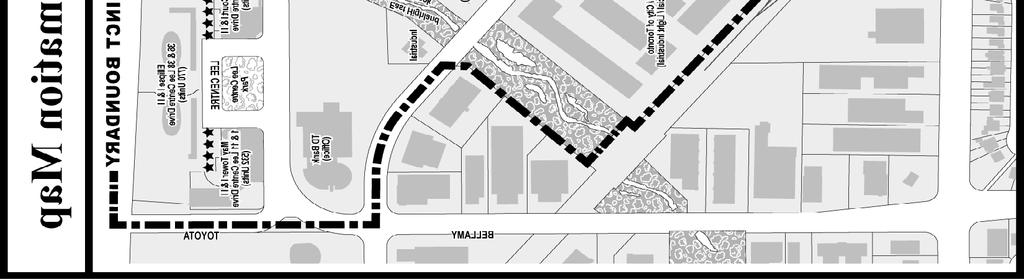
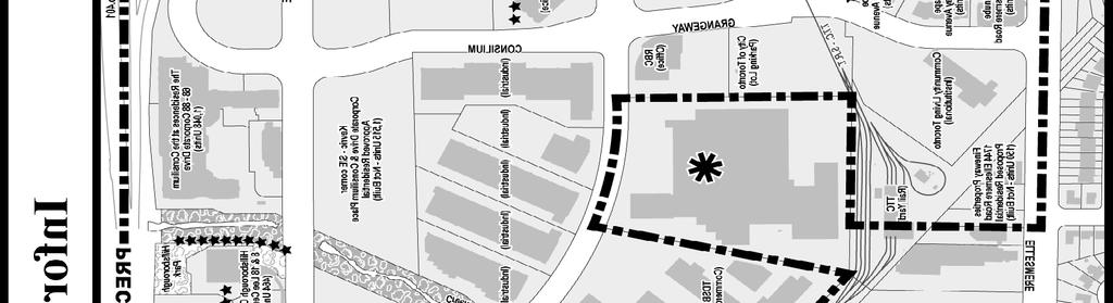
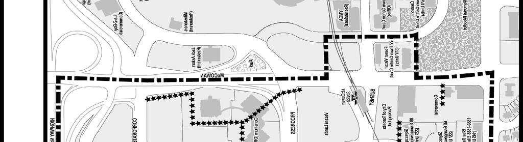
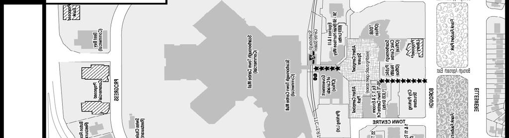
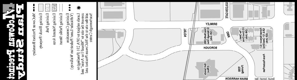
30 Attachment 1: McCowan Precinct Staff report for action Final Report McCowan Precinct Plan Study 30
31 Attachment 2: OPA No. 242 Authority: Scarborough Community Council Item ~ as adopted by City of Toronto Council on ~, Enacted by Council: ~, 2014 Bill No. ~ CITY OF TORONTO BY-LAW No. ~-2014 To adopt an amendment to the Official Plan for the City of Toronto respecting the lands within the Scarborough Centre WHEREAS authority is given to Council under the Planning Act, R.S.O. 1990, c.p. 13, as amended, to pass this By-law; WHEREAS Council of the City of Toronto has provided adequate information to the public and has held at least one public meeting in accordance with the Planning Act; The Council of the City of Toronto HEREBY ENACTS as follows: 1. The attached Amendment No. 242 to the City of Toronto Official Plan, consisting of the attached text and maps, shown on Schedule "A" is hereby adopted pursuant to the Planning Act, as amended. ENACTED AND PASSED this ~ day of ~, A.D ROB FORD, Mayor ULLI S. WATKISS, City Clerk (Corporate Seal) Staff report for action Final Report McCowan Precinct Plan Study 31
32 City of Toronto By-law No. ~~-2014 SCHEDULE "A" AMENDMENT NO. 242 TO THE OFFICIAL PLAN LANDS WITHIN THE SCARBOROUGH CENTRE IN THE YEAR 2013 The Official Plan of the City of Toronto is amended as follows: 1. Chapter 6, Secondary Plans, Section 5, Scarborough Centre Secondary Plan is amended by adding the following subsection to Section 8, Site and Area Specific Policies: 9 The McCowan Precinct Plan For the lands shown as 9 on Map 5-1: INTRODUCTION: The policies of this Precinct Plan are founded upon a "Vision" and "Guiding Principles" for the McCowan Precinct that have been developed by the residents, interested parties, landowners and workers who live, work and visit the McCowan Precinct and its surrounding areas. The Vision and Guiding principles form the basis of this Site & Area Specific Policy (No. 9) for the McCowan Precinct and are to be read and implemented in conjunction with the Council adopted "Conceptual Master Plan for McCowan Precinct" and the "McCowan Precinct Urban Design Guidelines", as amended by Council from time to time. Site & Area Specific Policy No. 9 includes policies to enhance and strengthen the designated land use(s) of the Staff report for action Final Report McCowan Precinct Plan Study 32
33 Precinct, including the employment base within the Precinct. Site & Area Specific Policy No. 9 also includes implementation policies and strategies, development principles and design strategies, guidance on future infrastructure investment; and identifies potential public and private improvements to parks, the transportation network and community and social services. 1.0 McCOWAN PRECINCT VISION: McCowan Precinct plays an important role within Scarborough Centre and the City of Toronto. The vision for the McCowan Precinct is for a vibrant, mixed use, community with urban characteristics that include: a focus of employment and housing; destination features for its residents, workers and visitors; a safe and pleasant place to live, work and play; pedestrian-friendly streets; transit-oriented built form; ease of movement; high quality architecture; great publicly accessible and connected parks and public spaces, and high levels of sustainability. It is intended that McCowan Precinct be a community within the Scarborough Centre that enjoys a strong relationship and connections with the Centre and the adjacent residential and employment communities. 1.2 GUIDING PRINCIPLES: MANAGING CHANGE: Future development of the McCowan Precinct will enhance the urban character and employment focus of the Precinct and the Scarborough Centre. Building upon, and in harmony with, the existing residential and employment uses within the Precinct, an urban community will be promoted through expansion and refinement of the existing street and block network, promotion of public spaces, parks and community services and facilities, public art and way-finding elements, promoting destination features for the people that live, work and visit the area, attention to building architecture, building placement, and providing for a gateway feature with elements that serve to announce arrival to the area and create a sense of place. Future residential and employment growth, together with public initiatives, will explore opportunities to achieve efficiencies in infrastructure servicing and energy use, including the potential for energy conservation. Future development and public initiatives will enhance and expand employment and residential opportunities, parks, open spaces, services, programs and facilities for the community, and opportunities to live, work and play in the area MOVEMENT: Movement and connectivity are keystones of the McCowan Precinct. Movement within, and connectivity between the Precinct and its surrounding communities will encompass a variety of modes of transportation and options. Development will be transit oriented and take advantage of public transit infrastructure. A Street and Block Plan as set out in the Conceptual Master Plan for the Precinct, will be based on a hierarchy of City streets, varying street typologies, and designs. An integrated network of pathways and sidewalks will be employed to encourage walking and cycling. Movement and connectivity will promote transit use, walking, cycling and efficient vehicular movement while providing a safe and attractive built environment for people to visit, live, and work within the Precinct. Staff report for action Final Report McCowan Precinct Plan Study 33
34 1.2.3 BUILDING COMMUNITIES: The McCowan Precinct will develop as a vibrant urban community within the Scarborough Centre, closely connected to its adjacent communities. Building upon the existing residential, employment, community, services and facilities, and the Precinct's parks, natural areas and public spaces, development of the Precinct will be designed to attract new businesses, visitors and residents. New development will provide for a diversity of housing and employment in keeping with the goals and objectives of the Scarborough Centre. New development and public initiatives will contribute to the livability and walk-ability of the Precinct through public realm improvements, the creation of public spaces, attention to the architecture and site design of new buildings and public infrastructure, contributions to the provision of community services and facilities and public art initiatives, efforts to achieve energy efficiencies and the promotion of opportunities to incorporate destination features that appeal to residents, workers and visitors of the area. Residential and employment growth, together with public initiatives, will facilitate investment in new social and physical infrastructure to create a rich mix of places for people to live, work, and visit. 2.0 MANAGING CHANGE: 2.1 Land Use: McCowan Precinct will develop as vibrant, well designed, mixed use community within the Scarborough Centre with a focus on employment uses. McCowan Precinct encompasses residential, employment, and recreational areas. This mix of uses will be enhanced to accommodate additional housing while creating additional employment and recreational opportunities within a transit supportive environment. Strategies to attract employment uses, particularly office, to form a significant proportion of the land use within the Precinct, will be pursued. In keeping with the vision of McCowan Precinct as an urban community, new development and public initiatives will be expected to incorporate the principles of urbanism which include, but are not limited to: - smaller development blocks; - close intersection spacing; - compact urban form; - appropriately scaled development; - active street edges; - a connected parks and public space system; - streetscape and public realm improvements; - public art; - enhanced vehicle, cycling, and pedestrian movement; - opportunities to "live, work and visit"; and - development and public initiatives that promote sustainability and incorporate "green" initiatives. Staff report for action Final Report McCowan Precinct Plan Study 34
35 2.2 Street & Block Plan: The McCowan Precinct "Conceptual Master Plan" will set out a "street and block plan" that seeks to create: - a finer grid of new public streets to promote development within larger land parcels; and - a network of public streets, pedestrian and bicycle connections, publically accessible lanes and walkways, and parks and public space system. Development within the McCowan Precinct will be guided by a street and block plan as set out in the Conceptual Master Plan and its components adopted by City Council A new network of public streets in the McCowan Precinct will support a balanced transportation system that includes walking, cycling, transit and vehicles as viable modes of transportation. As a condition of development approval, new public streets and publically accessible vehicular lanes and pedestrian walkways will be secured to provide additional and appropriate connections within the Precinct to facilitate and enhance vehicular, pedestrian and cyclist movement. New streets, lanes and walkways will divide existing larger parcels of land into more appropriately-sized development parcels that enable buildings to front onto public streets and will form an organizing framework for future development within the Precinct. Public streets will be required to be dedicated to the City where appropriate and desirable. Publically accessible lanes and driveways will be provided for both vehicular and pedestrian access, where appropriate and desirable. Publically accessible urban spaces will be encouraged as part of new development to enhance the public realm. The public street network within the McCowan Precinct will form a hierarchy of streets consisting of major streets and local streets. The planned street network for the McCowan Precinct is shown on the Conceptual Master Plan adopted by City Council. Locations on streets, including street intersections, where high volumes of pedestrian activity exist, or are anticipated, will be enhanced through the development review process with design features to create a pleasing and safe pedestrian/cyclist environment and appropriate, safe and functional vehicular movement. Such design features may include, but are not limited to one or more of the following: Staff report for action Final Report McCowan Precinct Plan Study 35
36 - enhancement or alteration of existing pedestrian routes; - provision of greater sidewalk widths and/or increased landscaped areas, - the creation of urban spaces through additional building setbacks; - street medians; - enhanced streetscape design; - way-finding signage; - cyclist routes; - pedestrian refuge areas within the street right-of-way; - enhanced street signalization; and - pavement treatment. New streets will be designed to be successful urban spaces which provide for vehicle, pedestrian and, where appropriate, bicycle movement through-out the Precinct and into neighbouring areas. New streets and the rehabilitation of existing streets will be designed to incorporate, as deemed appropriate, street trees, landscaping, street furniture, sidewalks, cycling facilities, and design features such as, but not limited to, decorative concrete, enhanced paving materials, pedestrian refuge areas, way-finding signage and lighting. 2.3 Conceptual Master Plan/Urban Design Guidelines: Site and Area Specific Policy No. 9, together with the City Council endorsed Conceptual Master Plan and Urban Design Guidelines for the McCowan Precinct will provide a plan for the future development of McCowan Precinct. The McCowan Precinct Urban Design Guidelines and the Conceptual Master Plan provide a visual illustration of the this plan and how the McCowan Precinct will develop over time. The Conceptual Master Plan will include a recommended street and block plan, connections network, parks, open space and urban spaces plan, and a pedestrian and cycling network. It is intended to be conceptual. Specific locations of proposed streets, connections, parks, public open spaces, cycling and pedestrian routes will be determined as development is reviewed and approved within the Precinct. The Conceptual Master Plan will provide guidance for new development and public initiatives. 2.4 McCowan Precinct Gateway Feature: The Conceptual Master Plan identifies the McCowan/Bushby/Progress area as a "Gateway". The intent is to recognize the importance of this area as a major connection and a "place of arrival" for the McCowan Precinct through such means as: - Enhanced Pedestrian Connection(s) - Destination Facility/Use - Public Space(s)/Gathering Space(s) - Public Transit Infrastructure - Building Placement - Public Art Staff report for action Final Report McCowan Precinct Plan Study 36
37 - Signage - Landscape Features The Gateway will function as the main vehicular, pedestrian and cyclist entrance to the McCowan Precinct. To enhance the Gateway function as a connection point between Precincts, the Gateway may to incorporate a variety of design features including: - pedestrian crossing infrastructure(s) that include clearly defined pedestrian routes that may be grade-related or associated with parks, open space and/or transit facilities; - greater sidewalk widths and/or increased landscaped areas and/or the creation of urban spaces through additional building setbacks; - street medians; - enhanced streetscape design; - landscape features; - public art; - way-finding signage; - pedestrian refuge areas within the street right-of-way; - enhanced street signalization; - pavement treatment; - street furnishings - street lighting; and - facilities that function as destination elements (eg. transit station/facilities). 2.5 Municipal Servicing & Stormwater Management Mitigation of the floodplain, and servicing and infrastructure matters and/or service upgrades to infrastructure needed to accommodate new development will be at the cost of the development proponent. In its review of development proposals, the City will pursue opportunities to implement the Wet Weather Flow Management Guidelines through the use of Low Impact Development (LID) stormwater management practices (such as rain gardens, infiltration galleries and bio-swales) incorporated into the design of streets and public spaces. LID practices shall be consistent with the TRCA s Low Impact Development Stormwater Management Planning and Design Guide, 2010, as amended and the City of Toronto's Green Development Standard Guidelines. Development will have regard for floodplain constraints within the Precinct, and geotechnical matters related to ground water/aquifer conditions. Development proposed within the floodplain in the Precinct will be required as part of the development review process, and in consultation with the City and the Toronto and Region Conservation Authority (TRCA), to undertake a study (or studies), to analyze, assess and identify options to remove any affected lands from Staff report for action Final Report McCowan Precinct Plan Study 37
38 the flood plain or sensitive areas. Such study may require an assessment of the physical works and costs necessary to mitigate any impacts or to remove the lands from the flood plain. 3.0 MOVEMENT: 3.1 Characteristics of the McCowan Street & Block Plan: The McCowan Precinct Conceptual Master Plan will promote a finer grid of streets and blocks for the McCowan Precinct than currently exists. Creating smaller sized development blocks, where previously large blocks of lands existed, through the introduction of a finer grain of public streets: - provides access and street frontages to new development; - promotes street-related development; - creates opportunities for intensification and the potential for new public spaces; and - encourages a pedestrian oriented and transit supportive environment. The Conceptual Master Plan will incorporate a street and a block plan for the McCowan Precinct that facilitates convenient and safe pedestrian, cycling and vehicular movement. The street and block plan will include: - a public street and connections network; - a finer grain of streets and development blocks, generally in the range of 0.36 to 0.7 hectares; - intersection spacing of approximately 80 to 150 metres; and - where development blocks cannot be sub-divided for size and engineering reasons, mid-block and perimeter connections may be considered, where appropriate and feasible, provided these connections are publicly accessible. Connections may include vehicular lanes, driveways and walkways. 3.2 Pedestrian Friendly Streets, Walkways, Lanes and Public Spaces: New public streets and walkways, and publically accessible lanes, driveways and walkways are will be designed to encourage and support safe and efficient movement of pedestrians, cyclists and vehicles. The City's Urban Design Guidelines will include design features and elements including but not limited to: paving details, street tree selection, landscaping, street furnishings, and street lighting, for public streets and private/publicallyaccessible lanes and walkways. The Urban Design Guidelines for the McCowan Precinct will include cross section designs for the various typologies of streets within the McCowan Precinct to guide the design/rehabilitation of new and existing streets. Staff report for action Final Report McCowan Precinct Plan Study 38
39 The design of all streets will provide suitable growing conditions and soil volume to allow for large growing street trees, consistent with the City's adopted and accepted Urban Forestry practices. 3.3 Public and Private Streets/Laneways: Where public streets are not feasible, desirable or appropriate, private streets may be considered provided that such private streets are: - publically accessible; - connect to the public street and block network; - designed to "look and act" as public streets; - pedestrian oriented; - include the qualities and design elements of public streets including but not limited to: sidewalks, lighting, high quality pavements and furnishings, irrigation, large growing trees and other landscape features and may include cycling lanes where appropriate; and - designed in such as manner as to invite and promote movement into/through the site. 3.4 Connections: Site and Area Specific Policy No. 9 for McCowan Precinct, together with the McCowan Conceptual Master Plan and Urban Design Guidelines will create a network of public streets and publically accessible lanes, driveways and pedestrian walkways to connect public and private land uses, including the natural areas, open spaces, parks and urban spaces of the McCowan Precinct. An extension of Bushby Drive to the lands at 705 Progress Avenue (the site of a future school and park will be designed as a grand promenade, a visual and physical link between the 705 Progress Avenue lands containing the future park and school site and the lands associated with the Civic Precinct of the Scarborough Centre. The "Bushby Drive Promenade" from Borough Drive to 705 Progress Avenue, will be designed with a generous right-of-way to create a linear green space that will act as a key organizing component of the McCowan Precinct, and the larger, Scarborough Centre public space system. 3.5 Cycling Network/Facilities: The McCowan Precinct will include a bicycle network to promote cycling as a transportation option for residents, workers and visitors to the Precinct. The cycling network will be implemented over time and will serve to enhance the Precinct's connectivity to the Scarborough Centre Precincts and the surrounding neighbourhoods. The McCowan Precinct Conceptual Master Plan illustrates opportunities for cycling connections that will include a combination of "separated cycle lanes", "marked bike Staff report for action Final Report McCowan Precinct Plan Study 39
40 lanes" and "sharrow lanes", as well as bike trails, where appropriate/feasible within parks and open space areas. The cycling network of the McCowan Precinct will be developed and implemented consistent with the City's Bicycle Plan/Network. As part of the development review process, new development and public initiatives will provide for cycling facilities as appropriate and feasible. Such facilities may include cycling routes, bicycle storage, signage or improvements/enhancements to existing cycling facilities. 3.6 Signage: The City will develop and a comprehensive way-finding plan for the McCowan Precinct that: - improves way-finding for pedestrians vehicles and cyclists moving within and around the McCowan Precinct; - creates a "Sense of Place" for the McCowan Precinct as a part of the Scarborough Centre, by identifying points of interest or significance; and; - provides guidelines for integration of signage and way-finding within the architecture and siting of existing and new buildings, in harmony with the City of Toronto Sign By-law, adopted guidelines and best practices. 3.7 Area Transportation Improvements: Area transportation improvements within the McCowan Precinct will be guided by the street and block plan as set out in the Conceptual Master Plan as well as transportation analysis and studies associated with development applications. The McCowan Precinct Plan contemplates future changes to the existing public street network. Potential new streets and refinements to the existing network are incorporated into the McCowan Precinct Conceptual Master Plan. The provision of new streets and potential refinements to the street network as illustrated on the Conceptual Master Plan are preliminary and flexible. The implementation of the street network, the location, alignment and design of new streets and improvements to existing streets, will be determined and refined through the development review process as development proceeds within the Precinct, through any required Environment Assessment process, and/or through City review and refinement of its transportation and transit network and facilities. Public transit infrastructure will form an important component of the McCowan Precinct. Development/public initiatives in the vicinity of public transit stations will be integrated with public transit infrastructure and connections. Staff report for action Final Report McCowan Precinct Plan Study 40
41 4.0 BUILDING COMMUNITIES: 4.1 Land Use: Transit supportive development will be required to support the public transit infrastructure of the McCowan Precinct. A variety of building types will be encouraged to provide a diversity of housing types. Residential buildings will provide a mix of unit sizes and bedrooms types to respond to the housing needs of residents including seniors and families. Townhouses are permitted as a "stand-alone" block that forms part of a larger, comprehensive development with a mix of building forms, where appropriate. Employment uses are an important feature of the McCowan Precinct. Employment use in the McCowan Precinct will be predominantly office use, hotels where, appropriate, community services and recreational facilities and retail uses that serve the residents, workers and visitors to the McCowan Precinct and adjacent communities. Major office development will be encouraged within the Precinct especially at locations in close proximity to public transit station facilities. Retail uses will be located at grade within residential, employment and public use buildings where appropriate. Retail may be located above grade, at a second storey of a building, provided that a primary, at-grade, street related entrance is provided. Grade-related retail and office uses can provide interest and animation to public streets and public spaces. Not all of the streets and public spaces within the McCowan Precinct streets can support, or are appropriate for retail uses. A focus of grade-related retail and commercial (office) uses, will be encouraged along: Consilium Place; Grangeway Avenue from Bushby Drive to Progress Avenue; Bushby Drive between Grangeway Avenue and McCowan Road; Town Centre Court (north side) from McCowan Road to Borough Drive and McCowan Road from Ellesmere Road to Bushby Drive. 4.2 Pedestrian Scale: New development will contribute to the establishment of a network of public streets, publically accessible lanes and walkways that are comfortable, safe, inviting, and scaled to the pedestrian. New buildings will be located on sites to create a common setback and build-to line with limited interruptions to encourage an interesting, interactive and varied pedestrian experience and public realm. Staff report for action Final Report McCowan Precinct Plan Study 41
42 Active, publicly-engaging ground floor uses will be provided along streets and private laneways and walkways, where appropriate. To create an active and pleasing pedestrian-scaled environment along streets and public spaces, building design features will include such features as: building setback, colonnades, building awnings/overhangs, glazing/fenestration, pedestrian entrances, and architectural materials to achieve visual interest. 4.3 Built Form The scale of development in the Precinct will be appropriate to its location and relationship to its surroundings including adjacent neighbourhoods, the public realm, parks and open spaces and its proximity to transportation facilities. Proposed development will respect relevant City urban design guidelines, standards and practises including, but not limited to, the City's Tall Buildings Guidelines, the Mid-rise Building Guidelines, the Design Guidelines for Buildings with Residential Units at Grade, the Urban Design Streetscape Manual, Toronto Green Development Standards and the Bird-Friendly Development Guidelines. High quality of design and architecture will be promoted for all development within the McCowan Precinct, including varied architectural treatments and materials for multi-phased developments.. Distinctive architecture, which creates signature buildings through the use of high quality design and materials and other architectural means, will be incorporated into all development within the Precinct. Taller buildings, especially the tower elements, should result in iconic, recognizable buildings in the skyline. Buildings will be designed, where appropriate and feasible, to create a continuous "street-wall", minimizing gaps along the street, except where public open spaces are located. As part of the development review process, new residential development will be encouraged to provide pet care facilities. 4.4 Streetscapes, Laneways and Walkways Streets, privately accessible laneways and walkways are to contribute to the greening of the Precinct and will incorporate features to provide suitable growing conditions for trees and soft landscaping. New development will contribute to the implementation of street improvement features to the existing and planned street network such as street furnishings, infrastructure improvements including cycling facilities, and landscaping. Such features will be co-ordinated with redevelopment and/or form part of the planned street rehabilitation/infrastructure improvements. Staff report for action Final Report McCowan Precinct Plan Study 42
43 4.5 Site Organization New developments, and in particular, the main entrance(s) to the building(s) will front onto public streets. Where appropriate, new development may front onto public parks and open spaces, provided the main entrance of the apartment- type building or, in the case of townhouse units (either stand-alone or incorporated into the base of an apartment building) fronts onto the public park or open space. Vehicle parking is to be located below grade. Surface parking is discouraged. 4.6 Public Open Spaces, Parks & Urban Spaces An integrated public space network consisting of natural areas, public parks/recreational areas, private and public urban spaces will be promoted, expanded and enhanced to create a more enjoyable Precinct for residents, workers and visitors. Public open spaces, parks, and privately-owned but publically accessible urban spaces will front onto public streets or have direct access from the public realm. The McCowan Urban Design Guidelines and the Conceptual Master Plan will identify locational opportunities for parks, open spaces and urban spaces. Where feasible and appropriate, new streets and blocks will incorporate public and/or publically accessible urban plazas to provide a series of outdoor spaces for public activity and to facilitate locations for public art. An urban plaza, immediately adjacent to the existing/planned McCowan RT Station or the planned McCowan Subway/transit facility is one of the key features of the Precinct Gateway and will form part of the redevelopment of the transit station/facilities and/or development on lands adjacent/in close proximity. Opportunities to expand the natural area and create parkland adjacent to the East Highland Creek valley corridor will be explored and implemented. The East Highland Creek valley corridor and its adjacent lands will be better linked to the Precinct through connections including pedestrian and cycling routes. The linear open space area, along East Highland Creek, south of Corporate Drive, to the existing/planned SRT and TTC lands will be expanded by a minimum of 10 metres from the top-of-bank and where appropriate, by a greater area, to: (a) provide additional natural area to enhance and protect the Natural Heritage System/natural habitat area; and (b) facilitate an important linkage between Hillsborough Park and the Lee Centre Park to, and within, the future school and park site at 705 Progress Avenue. Staff report for action Final Report McCowan Precinct Plan Study 43
44 The lands at 705 Progress Avenue will be developed as a park and school site. The park lands will function as a neighbourhood park, a gathering space for the local residents, visitors and workers within the McCowan Precinct. The park shall have frontage on one or more public streets. The park is to be linked to the Scarborough Centre by a well-designed and landscaped public street that will act as a visual link between the McCowan Precinct and the Scarborough Centre. The City will work with the Toronto District School Board (joint owners of the lands) to achieve coordinated and optimal shared use of recreational facilities and outdoor recreational resources on the 705 Progress Avenue lands. 4.7 Public Art The City will initiate a "McCowan Precinct Public Art Plan" as a component of an overall "Scarborough Centre Public Art Plan" that provides direction on how and where public art is to be conceptualized, planned, commissioned and implemented for individual locations or projects. The Scarborough Centre Public Art Plan will articulate public art principles and broad conceptual approaches to the provision of public art projects, identify opportunities for the location of public art on both public and private lands, and provide guidance to the provision of public art through contributions of pooled funds both by small and large development projects to contribute to larger public art projects. The McCowan Urban Design Guidelines and the Conceptual Master Plan will identify potential locations for public art including, parks, urban spaces, open spaces, public infrastructures and facilities, private lands and the public realm. Owners of development blocks in the McCowan Precinct greater than 0.5ha, will be encouraged to prepare a "project/block public art plan" detailing the means by which the owner intends to provide public art on the site(s). 4.8 Community Services and Facilities & Section 37 of the Planning Act New community services and facilities will be created and existing facilities/services expanded/refined to achieve the amount and range adequate to serve the current and future growth within the McCowan Precinct. As part of the development review process, the City will assess the need for new development to contribute to the provision of community services and facilities. Community services and facilities priorities for the McCowan Precinct include, but are not limited to: - public realm and streetscape improvements; - public art; - parks, open space and urban spaces; - Community Agency Space - Dedicated and accessible community agency space for non-profit service agencies to deliver a wide range of programs/services for all user groups, in particular, newcomers, youth and children; Staff report for action Final Report McCowan Precinct Plan Study 44
45 - Child Care - High quality and accessible non-profit licensed child care facilities, particularly for infants, toddlers and; and - Community Recreation Additional recreational facilities and/or satellite recreation space including a double gymnasium and large flexible multipurpose rooms to run programs for all user groups. 4.9 Community Energy New development and the re-development of existing buildings within the McCowan Precinct will contribute to achieving the City's target for reducing energy use and reducing greenhouse gas emissions. Proponents of new development and redevelopment of existing buildings will be guided by the Community Energy Plan prepared as part of the McCowan Precinct Plan Study (2014) and will work with the City to assess opportunities to contribute to the City's energy targets through sustainable development. Development is encouraged to promote and accommodate renewable energy generation and distribution systems to assist in reducing greenhouse emissions, off- setting on site energy consumption, and securing a sustainable and stable energy distribution and supply. Energy technologies such as geothermal, combined heat and power co-generation, solar thermal heating, solar cooling, heat recovery, short- and long-term energy storage, and solar photo-voltaic will be encouraged. Building design and site planning to achieve passive solar heating in cold weather months will also be encouraged. Development will be encouraged to incorporate facilities to re-charge electricpowered vehicles either as a private or common amenity for building occupants or on pay-per-use basis for the general public. The City will encourage alternative energy technologies to power new street lighting, traffic signals, and other lighting in the public realm. As part of the development review process, proponents for new development that includes a building or group of buildings with a total gross floor area of 20,000 square metres or more, will be encouraged to provide an Energy Plan for the development that addresses energy conservation, peak demand reduction, improved resilience to area-wide power outages (i.e. flood and storm); renewable energy, combined heat and power, and district energy systems, as set out in the Scarborough Centre Community Energy Plan Vehicle Parking The policies of the Scarborough Centre Secondary Plan promote and support the use of public transit, walking, and cycling. A reduced parking supply may be considered for developments that are in close proximity to transit facilities, or upon review and acceptance by the City, incorporate programs/features such as car-share programs that would serve to reduce the dependence on the automobile. Staff report for action Final Report McCowan Precinct Plan Study 45
46 2. Map 5-1, Scarborough Centre Secondary Plan, "Urban Structure Plan", is amended to show the lands known as "The McCowan Precinct" as Site and Area Specific Policy Area No. 9, as shown on the attached Schedule "B". Staff report for action Final Report McCowan Precinct Plan Study 46
47 City of Toronto By-law No. ~~-20~ Schedule "B" Map 5.1 Staff report for action Final Report McCowan Precinct Plan Study 47
48 Attachment 3: Urban Design Guidelines Provided as a Separate Attachment at the end of this Report Staff report for action Final Report McCowan Precinct Plan Study 48


49 Attachment 4A: Conceptual Master Plan Staff report for action Final Report McCowan Precinct Plan Study 49

 Staff")

50 Attachment 4B: Conceptual Master Plan: Cycling Network) Staff report for action Final Report McCowan Precinct Plan Study 50
McCowan Precinct Plan Study Background & Deliverables
 1 DRAFT & WITHOUT PREJUDICE McCowan Precinct Plan Study Background & Deliverables In September, 2011, City Planning (Scarborough District) began a study of an area within the Scarborough Centre, identified
SCARBOROUGH SUBWAY EXTENSION. Scarborough Subway Extension. Final Terms of Reference
 Scarborough Subway Extension Final Terms of Reference 1 1.0 Introduction and Background 1.1 Introduction Toronto City Council recently confirmed support for an extension of the Bloor-Danforth Subway from
PILLAR FOUR INTEGRATE LAND USE & TRANSPORTATION
 PILLAR FOUR INTEGRATE LAND USE & TRANSPORTATION 8 Scarborough Centre on the Move Transportation Master Plan 123 8 Transportation Pillar Four Integrate Land Use & The fourth pillar focuses on the relationship
1.0 Purpose of a Secondary Plan for the Masonville Transit Village
 Report to Planning and Environment Committee To: Chair and Members Planning & Environment Committee From: John M. Fleming Managing Director, Planning and City Planner Subject: Masonville Transit Village
Official Plan Review: Draft Built Form Policies
 PG.30.1 REPORT FOR ACTION Official Plan Review: Draft Built Form Policies Date: May 15, 2018 To: Planning and Growth Management Committee From: Chief Planner and Executive Director, City Planning Division
Bloor St. W. Rezoning - Preliminary Report
 STAFF REPORT ACTION REQUIRED 1638-1644 Bloor St. W. Rezoning - Preliminary Report Date: April 1, 2008 To: From: Wards: Reference Number: Toronto and East York Community Council Acting Director, Community
WELCOME. The Yonge-Eglinton area has experienced significant growth and change in the last decade.
 WELCOME DID YOU KNOW? MIDTOWN IS REPRESENTED BY 3 CITY COUNCILLORS: WARD 16 EGLINTON-LAWRENCE WARD 22 ST. PAUL S WARD 25 DON VALLEY WEST Midtown in Focus: Building a Livable Yonge-Eglinton The Yonge-Eglinton
St. Lawrence Neighbourhood Focused Area - Official Plan Amendment Status Report
 STAFF REPORT ACTION REQUIRED St. Lawrence Neighbourhood Focused Area - Official Plan Amendment Status Report Date: May 21, 2015 To: From: Wards: Reference Number: Toronto and East York Community Council
PART 1. Background to the Study. Avenue Study. The Danforth
 The Danforth 1.1/ Study Purpose & Key Municipal Goals 1.2/ The Local Advisory Committee 1.3/ The Project Team 1.4/ Study Process/Summary of Method 1.5/ Summary of Consultation 1.1 Study Purpose and Key
ELMVALE ACRES SHOPPING CENTRE MASTER PLAN
 ELMVALE ACRES SHOPPING CENTRE MASTER PLAN Contents 1.0 INTRODUCTION... 2 2.0 LOCATION... 2 3.0 EXISTING CONTEXT... 2 4.0 VISION & GUIDING PRINCIPLES... 2 5.0 LAND USE AND BUILT FORM... 4 5.1 St. Laurent
Public Open House. Overview of the Downtown Plan Official Plan Amendment April 23, 2018
 Public Open House Overview of the Downtown Plan Official Plan Amendment April 23, 2018 1 A 25-Year Plan for Downtown To ensure growth contributes positively to Toronto s Downtown as a great place to live,
SECTION ONE: INTRODUCTION. introduction
 introduction 1 INTRODUCTION Since it was first established in 1843 as a trading post for the Hudson s Bay Company, Victoria has evolved into a Provincial capital city that is recognized across Canada and
SUBJECT: Waterfront Hotel Planning Study Update TO: Planning and Development Committee FROM: Department of City Building. Recommendation: Purpose:
 Page 1 of Report PB-23-18 SUBJECT: Waterfront Hotel Planning Study Update TO: Planning and Development Committee FROM: Department of City Building Report Number: PB-23-18 Wards Affected: 2 File Numbers:
Welcome. Walk Around. Talk to Us. Write Down Your Comments
 Welcome This is an information meeting introducing the applications for proposed redevelopment of the Yorkdale Shopping Centre site at 3401 Dufferin Street and 1 Yorkdale Road over the next 20+ years,
THAT the attached Terms of Reference for the Thornhill Centre Street Study be approved.
 COMMITTEE OF THE WHOLE AUGUST 18, 2003 THORNHILL CENTRE STREET STUDY PLANNING FILE: 15.92 Recommendation The Commissioner of Planning recommends: THAT the attached Terms of Reference for the Thornhill
Urban Design Manual PLANNING AROUND RAPID TRANSIT STATIONS (PARTS) Introduction. Station Study Areas
 Introduction. Station Study Areas") 111111 PLANNING AROUND RAPID TRANSIT STATIONS (PARTS) Introduction The ION rapid transit system will link Waterloo, Kitchener and Cambridge through a central transit corridor (CTC). There are a number
111111 PLANNING AROUND RAPID TRANSIT STATIONS (PARTS) Introduction The ION rapid transit system will link Waterloo, Kitchener and Cambridge through a central transit corridor (CTC). There are a number
Eglinton Avenue East & 50 Thermos Road - Official Plan Amendment Application Preliminary Report
 STAFF REPORT ACTION REQUIRED 1966 2050 Eglinton Avenue East & 50 Thermos Road - Official Plan Amendment Application Preliminary Report Date: March 15, 2016 To: From: Wards: Reference Number: Scarborough
YONGE STEELES CORRIDOR SECONDARY PLAN. Young + Wright / IBI Group Architects Dillon Consulting Ltd. GHK International (Canada) Ltd.
 Ltd.") PART A: PREAMBLE 1.0 PURPOSE The purpose of this Secondary Plan is to provide a development framework for intensification of the Yonge/ Steeles corridor including the north side of Steeles Avenue West
PART A: PREAMBLE 1.0 PURPOSE The purpose of this Secondary Plan is to provide a development framework for intensification of the Yonge/ Steeles corridor including the north side of Steeles Avenue West
Scarborough Centre Transportation Master Plan Final Report
 REPORT FOR ACTION Scarborough Centre Transportation Master Plan Final Report Date: April 11, 2018 To: Scarborough Community Council From: Director Transit and Transportation Planning and Director Community
Span McCowan and Market Building Proposal
 STAFF REPORT ACTION REQUIRED Span McCowan and Market Building Proposal Date: April 23, 2014 To: From: Wards: Reference Number: Scarborough Community Council Raymond David, Director, Community Planning,
12 AMENDMENT NO. 149, TOWN OF MARKHAM HIGHWAY 404 NORTH SECONDARY PLAN
 12 AMENDMENT NO. 149, TOWN OF MARKHAM HIGHWAY 404 NORTH SECONDARY PLAN The Planning and Economic Development Committee recommends the adoption of the recommendation contained in the following report August
178 Carruthers Properties Inc.
 178 Carruthers Properties Inc. Planning Rationale for 178 Carruthers Avenue Site Plan Control Application June 2014 Table of Contents 1.0 Introduction 2.0 Overview of Subject Property 3.0 Current Zoning
13 THORNHILL YONGE STREET STUDY IMPLEMENTATION CITY OF VAUGHAN OPA 669 AND TOWN OF MARKHAM OPA 154
 13 THORNHILL YONGE STREET STUDY IMPLEMENTATION CITY OF VAUGHAN OPA 669 AND TOWN OF MARKHAM OPA 154 The Planning and Economic Development Committee recommends the adoption of the recommendations contained
CITY CLERK. Parkland Acquisition Strategic Directions Report (All Wards)
") CITY CLERK Clause embodied in Report No. 10 of the, as adopted by the Council of the City of Toronto at its meeting held on November 6, 7 and 8, 2001. 10 Parkland Acquisition Strategic Directions Report
CITY CLERK Clause embodied in Report No. 10 of the, as adopted by the Council of the City of Toronto at its meeting held on November 6, 7 and 8, 2001. 10 Parkland Acquisition Strategic Directions Report
1071 King Street West Zoning Amendment Application - Preliminary Report
 STAFF REPORT ACTION REQUIRED 1071 King Street West Zoning Amendment Application - Preliminary Report Date: August 9, 2012 To: From: Wards: Reference Number: Toronto and East York Community Council Director,
9 CITY OF VAUGHAN OFFICIAL PLAN AMENDMENT NO BOCA EAST INVESTMENTS LIMITED
 9 CITY OF VAUGHAN OFFICIAL PLAN AMENDMENT NO. 631 - BOCA EAST INVESTMENTS LIMITED The Planning and Economic Development Committee recommends the adoption of the recommendations contained in the following
Welcome to the Oakridge Centre Open House
 Welcome to the Oakridge Centre Open House Why is the City hosting this event? This open house is to inform you of a rezoning application submitted to the City of Vancouver to amend the existing CD-1 (Comprehensive
5 TOWN OF MARKHAM OFFICIAL PLAN AMENDMENT NO. 144 MILLIKEN MAIN STREET SECONDARY PLAN
 5 TOWN OF MARKHAM OFFICIAL PLAN AMENDMENT NO. 144 MILLIKEN MAIN STREET SECONDARY PLAN The Planning and Economic Development Committee recommends the following: 1. The communication from Brendan O Callaghan,
Agincourt Mall Planning Framework Review Status Report
 STAFF REPORT ACTION REQUIRED Agincourt Mall Planning Framework Review Status Report Date: May 16, 2018 To: From: Scarborough Community Council Director, Community Planning, Scarborough District Wards:
4121 Lawrence Avenue East Rezoning Application Preliminary Report
 STAFF REPORT ACTION REQUIRED 4121 Lawrence Avenue East Rezoning Application Preliminary Report Date: October 11, 2011 To: From: Wards: Reference Number: Scarborough Community Council Director, Community
38 Queen s University Campus Master Plan Part 1
 38 Queen s University Campus Master Plan Part 1 46 The Campus at the City Scale Chapter 4 The Campus at the City Scale 39 Queen s is an urban University centrally located in Kingston. Decisions made by
K. SMART ASSOCIATES LIMITED
 Planning Justification Report Zoning By-Law Amendment 185 King Street North Waterloo, Ontario April 7th, 2017 Project Reference Number 16-245 K. SMART ASSOCIATES LIMITED CONSULTING ENGINEERS AND PLANNERS
599 Kennedy Road - Official Plan Amendment and Zoning Amendment Application - Preliminary Report
 STAFF REPORT ACTION REQUIRED 599 Kennedy Road - Official Plan Amendment and Zoning Amendment Application - Preliminary Report Date: March 7, 2017 To: From: Wards: Reference Number: Scarborough Community
7437, 7439 and 7441 Kingston Road - Zoning By-law Amendment and Site Plan Control Applications - Preliminary Report
 STAFF REPORT ACTION REQUIRED 7437, 7439 and 7441 Kingston Road - Zoning By-law Amendment and Site Plan Control Applications - Preliminary Report Date: August 13, 2015 To: From: Wards: Reference Number:
Local Growth Planning in North Central Green Line Communities
 2018 April 30 Page 1 of 6 EXECUTIVE SUMMARY This report outlines a high-level scope for local growth planning for north central Green Line communities. The catalyst for this review is the significant investments
The transportation system in a community is an
 7 TRANSPORTATION The transportation system in a community is an important factor contributing to the quality of life of the residents. Without a sound transportation system to bring both goods and patrons
Port Credit Local Advisory Panel October 20 th Meeting
 Port Credit Local Advisory Panel October 20 th Meeting Focus Of This Evening s Meeting: 1. Hurontario Main Street Higher Order Transit Study 2. Port Credit Mobility Hub & GO Station Parking Structure Study
1296 Kennedy Road - Zoning Amendment Application - Preliminary Report
 STAFF REPORT ACTION REQUIRED 1296 Kennedy Road - Zoning Amendment Application - Preliminary Report Date: January 15, 2016 To: From: Wards: Reference Number: Scarborough Community Council Acting Director,
3. Endorse the LRT vision in transforming Surrey into Connected-Complete-Livable communities, and more specifically, the official vision statement:
 CORPORATE REPORT NO: R038 COUNCIL DATE: February 20, 2017 REGULAR COUNCIL TO: Mayor & Council DATE: February 16, 2017 FROM: General Manager, Engineering FILE: 8740-01 SUBJECT: Surrey Light Rail Transit
South of Eastern Strategic Direction Status Update
 STAFF REPORT ACTION REQUIRED South of Eastern Strategic Direction Status Update Date: July 10, 2014 To: From: Planning and Growth Management Committee Chief Planner and Executive Director, City Planning
6 Growth Management Challenges and Opportunities
 6 Growth Management Challenges and Opportunities The Town has established a goal of attaining a 50% participation rate with respect to employment opportunities versus residential population. The Town s
THE CITY OF VAUGHAN BY-LAW BY-LAW NUMBER A By-law to adopt Amendment Number 1 to the Official Plan of the Vaughan Planning Area.
 THE CITY OF VAUGHAN BY-LAW BY-LAW NUMBER 015-2014 A By-law to adopt Amendment Number 1 to the Official Plan of the Vaughan Planning Area. NOW THEREFORE the Council of the Corporation of the City of Vaughan
[PLANNING RATIONALE] For Site Plan Control and Lifting of Holding Zone By-Law 101 Champagne Avenue. May 23, 2014
![[PLANNING RATIONALE] For Site Plan Control and Lifting of Holding Zone By-Law 101 Champagne Avenue. May 23, 2014](/thumbs/75/71599615.jpg "[PLANNING RATIONALE] For Site Plan Control and Lifting of Holding Zone By-Law 101 Champagne Avenue. May 23, 2014") [PLANNING RATIONALE] For Site Plan Control and Lifting of Holding Zone By-Law 101 Champagne Avenue May 23, 2014 Contents 1.0 Introduction... 2 2.0 Site Context... 2 2.1 Adjacent Uses... 2 Figure 1: Site
[PLANNING RATIONALE] For Site Plan Control and Lifting of Holding Zone By-Law 101 Champagne Avenue May 23, 2014 Contents 1.0 Introduction... 2 2.0 Site Context... 2 2.1 Adjacent Uses... 2 Figure 1: Site
Tippett Road Area Regeneration Study Final Report. Planning and Growth Management Committee
 PG8.6 STAFF REPORT ACTION REQUIRED Tippett Road Area Regeneration Study Final Report Date: October 23, 2015 To: From: Wards: Reference Number: Planning and Growth Management Committee Chief Planner and
WELCOME and introduction
 1 WELCOME and introduction Mobility Hub Locations within Burlington STUDY OVERVIEW STUDY OBJECTIVES The City of Burlington is developing four Area Specific Plans, one for each of Burlington s Mobility
and services The protection and conservation of environmentally significant and sensitive natural heritage features and functions.
 6. Land Use 6.0 Preamble A healthy and livable city is one in which people can enjoy a vibrant economy and a sustainable healthy environment in safe, caring and diverse neighbourhoods. In order to ensure
City of Toronto Official Plan Indicators
 City of Toronto Official Plan Indicators Attachment 1 2017 Gladki Planning Associates in association with Hemson Consulting & Studio Jaywall City of Toronto Official Plan Indicators 1 Introduction What
Downtown Streetscape Manual & Built Form Standards
 City of Guelph Downtown Streetscape Manual & Built Form Standards July 2014 Prepared by Brook McIlroy Inc. in association with Unterman McPhail Associates and McCormick Rankin Inc. City of Guelph Downtown
150 Eighth Street Zoning By-law Amendment Application Preliminary Report
 REPORT FOR ACTION 150 Eighth Street Zoning By-law Amendment Application Preliminary Report Date: March 27, 2019 To: Etobicoke York Community Council From: Director, Community Planning, Etobicoke York District
The Corporation of the Town of Milton
 Report To: From: Council Barbara Koopmans, Commissioner, Planning and Development Date: May 7, 2018 Report No: Subject: Making it Possible Positioning the Town s Strategy for Growth and Economic Development
This page has been intentionally left blank.
 This page has been intentionally left blank. Chapter 3 3-2 3. Employment 3.A Niagara Economic Gateway 3.A.1 General The Niagara Economic Gateway comprises: a) The Gateway Economic Zone which includes all
The West Vaughan Employment Area Secondary Plan Policies
 Part 2: The West Vaughan Employment Area Secondary Plan Policies 2.1 General Policies It is the policy of Council: 2.1.1. That the West Vaughan Employment Area (the WVEA), identified on Schedule 1, will
Director, Community Planning, North York District
 Final Report Lawrence-Allen Secondary Plan Date: October 17, 2011 STAFF REPORT ACTION REQUIRED To: From: Wards: Reference Number: North York Community Council Director, Community Planning, North York District
City-Initiated Official Plan and Zoning By-law Amendments, Yonge-Eglinton Centre Focused Review Final Report
 STAFF REPORT ACTION REQUIRED City-Initiated Official Plan and Zoning By-law Amendments, Yonge-Eglinton Centre Focused Review Final Report Date: January 5, 2009 To: From: Planning and Growth Management
280 Manse Road - Official Plan Amendment, Zoning Amendment, Draft Plan of Subdivision Applications - Preliminary Report
 STAFF REPORT ACTION REQUIRED 280 Manse Road - Official Plan Amendment, Zoning Amendment, Draft Plan of Subdivision Applications - Preliminary Report Date: March 11, 2014 To: From: Wards: Reference Number:
DAVENPORT VILLAGE SECONDARY PLAN
 27 DAVENPORT VILLAGE SECONDARY PLAN 27. DAVENPORT VILLAGE SECONDARY PLAN 1. VISION FOR THE DAVENPORT VILLAGE SECONDARY PLAN Davenport Village, municipally known as 830, 940, 980 and 1100 Lansdowne Avenue,
SUBJECT: Proposed Downtown Mobility Hub Precinct Plan and Proposed Official Plan Policies
 Page 1 of Report PB-81-17 SUBJECT: Proposed Downtown Mobility Hub Precinct Plan and Proposed Official Plan Policies TO: FROM: Committee of the Whole Planning and Building Department Report Number: PB-81-17
Don Mills Crossing Study and Celestica Lands Development Application Community Meeting, Open House, and Breakout Discussions
 Consultation Summary Don Mills Crossing Study and Celestica Lands Development Application Community Meeting, Open House, and Breakout Discussions This report is not intended to provide a verbatim transcript
PUBLIC OPEN HOUSE HURONTARIO-MAIN CORRIDOR SECONDARY PLAN
 PUBLIC OPEN HOUSE HURONTARIO-MAIN CORRIDOR SECONDARY PLAN Tuesday, February 28, 2012 6pm 9pm 1 st Floor Atrium, City Hall 2 Wellington Street West, Brampton 1 POLICY FRAMEWORK The 2006 Provincial Growth
SUBJECT: GO Station Mobility Hubs Preferred Concepts: Aldershot GO, Burlington GO and Appleby GO. Planning and Development Committee - Public Meeting
 Page 1 of Report PB-76-17 SUBJECT: GO Station Mobility Hubs Preferred Concepts: Aldershot GO, Burlington GO and Appleby GO TO: FROM: Planning and Development Committee - Public Meeting Planning and Building
Report to: Development Services Committee Report Date: September 11, 2017
 ~RKHAM Report to: Development Services Committee Report Date: September 11, 2017 SUBJECT: PREPARED BY: Conceptual Master Plan for the Future Urban Area - Community Structure Plan and Key Policy Direction
Coordinated Transit Planning in Toronto SmartTrack GO RER Scarborough Relief Line Waterfront Transit
 Coordinated Transit Planning in Toronto SmartTrack GO RER Scarborough Relief Line Waterfront Transit Public Information Centres February 2016 Transportation Planning Section City Planning Division Toronto
WITNESS STATEMENT Of. Ronald Blake. On behalf of the Intervenor The Corporation of the City of Markham
 Filed: 2013-06028 EB-2012-0451 Exhibit L.EGD.COM.2 Page 1 of 7 WITNESS STATEMENT Of Ronald Blake On behalf of the Intervenor The Corporation of the City of Markham In the matter of an application by Enbridge
2.0 A FRAMEWORK FOR SUSTAINABLE GROWTH CONTENTS
 2-2 A Framework for Sustainable Growth 2.0 A FRAMEWORK FOR SUSTAINABLE GROWTH CONTENTS 2.1 MANAGING SUSTAINABLE GROWTH THE VISION TO 2031 2.2 GOALS AND OBJECTIVES 2.2.1 Protecting the Natural Environment
Derry Green Corporate Business Park
 Town of Milton Derry Green Corporate Business Park Urban Design Guidelines BMI/Pace - June 2010 Draft 3 Prepared by: Brook McIlroy Planning + Urban Design / Pace Architects Suite 300-51 Camden Street Toronto,
PORT WHITBY COMMUNITY
 PORT WHITBY COMMUNITY SECONDARY PLAN UPDATE COMMUNITY IMPROVEMENT PLAN URBAN DESIGN GUIDELINES September 2015 DRAFT PROPOSED AMENDMENT NUMBER # to the Whitby Official Plan PURPOSE: The intent of this Amendment
808 Mount Pleasant Road Zoning Amendment Application Request for Interim Direction Report
 STAFF REPORT ACTION REQUIRED 808 Mount Pleasant Road Zoning Amendment Application Request for Interim Direction Report Date: June 15, 2018 To: From: Wards: Reference Number: Toronto and East York Community
New-Cast Mixed-use Development Proposal King Street West, Newcastle, Ontario
 URBAN DESIGN BRIEF New-Cast Mixed-use Development Proposal King Street West, Newcastle, Ontario TABLE OF CONTENTS: 1.0 Executive Summary 2.0 Creating Vibrant and Sustainable Urban Places: Excerpts from
Implementation Guide Comprehensive Plan City of Allen
 Implementation Guide 2030 Comprehensive Plan City of Allen DRAFT 2015 Implementation Guide Allen 2030 Comprehensive Plan INTRODUCTION The Comprehensive Plan serves as a guide for the growth and development
This report presents the draft Don Mills Crossing Secondary Plan for public consultation.
 PG30.6 REPORT FOR ACTION Don Mills Crossing - Proposals Report Date: May 17, 2018 To: Planning and Growth Management Committee From: Chief Planner and Executive Director, City Planning Division Wards:
Planning for the Future Urban Area. in north Markham. Update. Development Services Committee. December 9, De Development Services Committee
 Planning for the in north Markham 1 Update De December 9, 2014 Overview - Growth Management Strategy and new Official Plan 2014 Status - Official Plan 2014 and ROPA3 Update - Planning for the Future Urban
Town of Oakville Streetscape Strategy
 Town of Oakville Streetscape Strategy Endorsed by PDC on February 10, 2014 (PD-011-14) Town of Oakville Streetscape Strategy [endorsed by PDC February 10, 2014] 0 Town of Oakville Streetscape Strategy
Complete Neighbourhood Guidelines Review Tool
 Complete Neighbourhood Guidelines Review Tool Prepared By: City of Regina Planning Department October 2014 Page 1 of 14 Community Development Review Checklist for Secondary Plans and Concept Plans The
The Master Plan Framework
 The Master Plan Framework The East Harbour Master Plan advances the development of 60 acres of former industrial lands east of the Don River. The Master Plan outlines a vision for a vibrant, transit-oriented
John M. Fleming Managing Director, Planning and City Planner. Old East Village Dundas Street Corridor Secondary Plan Draft Terms of Reference
 Report to Planning and Environment Committee To: From: Subject: Chair and Members Planning & Environment Committee John M. Fleming Managing Director, Planning and City Planner Old East Village Dundas Street
Long Branch Neighbourhood Character Guidelines Final Report
 STAFF REPORT ACTION REQUIRED Long Branch Neighbourhood Character Guidelines Final Report Date: October 26, 2017 To: From: Wards: Reference Number: Etobicoke York Community Council Director, Community Planning,
CONTENTS 2.0 A FRAMEWORK FOR SUSTAINABLE GROWTH 2.1 MANAGING SUSTAINABLE GROWTH THE VISION TO GOALS AND OBJECTIVES 2.3 MARKHAM STRUCTURE
 2 A Framework for Sustainable Growth 2.0 A FRAMEWORK FOR SUSTAINABLE GROWTH CONTENTS 2.1 MANAGING SUSTAINABLE GROWTH THE VISION TO 2031 2.2 GOALS AND OBJECTIVES 2.2.1 Protecting the Natural Environment
and Richmond Street West - Official Plan Amendment Application - Preliminary Report
 STAFF REPORT ACTION REQUIRED 822-838 and 860-862 Richmond Street West - Official Plan Amendment Application - Preliminary Report Date: August 14, 2017 To: From: Wards: Reference Number: Toronto and East
Relief Line Project Assessment
 Relief Line Project Assessment Public Information Centre April 5, 2017 Tonight s Meeting PURPOSE To review the preferred alignment for the Local Segment. AGENDA 6:30 Open House 7:00 Presentation / Discussion
AGINCOURT SECONDARY PLAN
 1 AGINCOURT SECONDARY PLAN 1. AGINCOURT SECONDARY PLAN The following policies and principles apply to the area herein referred to as Agincourt, as outlined on Map 1-1. 1. GENERAL POLICIES 1.1 This Secondary
*** DRAFT 2 FOR PUBLIC REVIEW ***
 6.7 The area is generally bounded by the Red Hill Valley Parkway to the west, Lake Avenue to the east, the Queen Elizabeth Way (QEW) to the north, and by the properties just south of Queenston Road to
CITY OF VAUGHAN EXTRACT FROM COUNCIL MEETING MINUTES OF NOVEMBER 15, 2016
 Item 11, Report No. 38, of the Committee of the Whole, which was adopted without amendment by the Council of the City of Vaughan on November 15, 2016. Regional Councillor Di Biase declared an interest
Shift Rapid Transit Public Participation Meeting May 3, 2017
 Shift Rapid Transit Public Participation Meeting May 3, 2017 Shift Rapid Transit Initiative Largest infrastructure project in the city s history. Rapid Transit initiative will transform London s public
FORMER CANADIAN FORCES BASE (CFB) ROCKCLIFFE SECONDARY PLAN. Official Plan Amendment XX to the Official Plan for the City of Ottawa
 ROCKCLIFFE SECONDARY PLAN. Official Plan Amendment XX to the Official Plan for the City of Ottawa") FORMER CANADIAN FORCES BASE (CFB) ROCKCLIFFE SECONDARY PLAN Official Plan Amendment XX to the Official Plan for the City of Ottawa 1 INDEX THE STATEMENT OF COMPONENTS PART A THE PREAMBLE PAGE Purpose...
FORMER CANADIAN FORCES BASE (CFB) ROCKCLIFFE SECONDARY PLAN Official Plan Amendment XX to the Official Plan for the City of Ottawa 1 INDEX THE STATEMENT OF COMPONENTS PART A THE PREAMBLE PAGE Purpose...
Queen Street West - Zoning Amendment Application - Preliminary Report
 STAFF REPORT ACTION REQUIRED 944-952 Queen Street West - Zoning Amendment Application - Preliminary Report Date: February 6, 2013 To: From: Wards: Reference Number: Toronto and East York Community Council
Official Plan Review
 Official Plan Review Summary Report - The Built Environment August 2014 Part 1: Introduction Planning for a healthy, prosperous and sustainable community is an important goal for our municipality. From
PLAN ELEMENTS WORKSHOP. April 5, 2016
 PLAN ELEMENTS WORKSHOP April 5, 2016 needs more housing. But there is no one-size fits-all solution. Every neighborhood has its own character. In some places, density is not only appropriate it is badly
hermitage town center
 hermitage town center A Community Vision prepared by Strada for The City of Hermitage and The Mercer County Regional Planning Commission January 2007 table of contents introduction 3 design principles
UTSC SECONDARY PLAN COMMUNITY OPEN HOUSE
 WELCOME TO THE UTSC SECONDARY PLAN COMMUNITY OPEN HOUSE 1 Welcome to the first Community Open House for the UTSC Secondary Plan. Hosted by the University of Toronto Scarborough (UTSC), the following panels
Clairtrell Area Context Plan
 Clairtrell Area Context Plan March 2005 Urban Development Services City Planning Contents 1. Introduction... 4 2. Development Structure... 6 2.1 Streets... 7 2.1.1 Sheppard Avenue and Bayview Avenue...
4800 Yonge Street - Official Plan Amendment, Zoning Amendment and Site Plan Applications - Request for Direction Report
 STAFF REPORT ACTION REQUIRED 4800 Yonge Street - Official Plan Amendment, Zoning Amendment and Site Plan Applications - Request for Direction Report Date: April 16, 2018 To: From: Wards: Reference Number:
4780 Eglinton Avenue West - Zoning By-law Amendment and Draft Plan of Subdivision Applications - Preliminary Report
 STAFF REPORT ACTION REQUIRED 4780 Eglinton Avenue West - Zoning By-law Amendment and Draft Plan of Subdivision Applications - Preliminary Report Date: May 29, 2014 To: From: Wards: Reference Number: Etobicoke
Commercial, Retail and Tourism Executive Summary December 2018
 Town of Wasaga Beach Official Plan Review, Retail and Executive Summary December 2018 1 An Official Plan directs where and how to grow The preparation of a new Official Plan for Wasaga Beach is an opportunity
Finch Avenue West and Sheppard Avenue East Corridors - Planning Study Approach. Planning and Growth Management Committee
 PG8.9 STAFF REPORT ACTION REQUIRED Finch Avenue West and Sheppard Avenue East Corridors - Planning Study Approach Date: October 13, 2015 To: From: Planning and Growth Management Committee Chief Planner
City of Welland Commercial Policies. Public Information Centre March 25 th, 2009
 City of Welland Commercial Policies Public Information Centre March 25 th, 2009 Presentation Outline Presentation will address the following four areas: Purpose of this Public Information Centre? Why does
Mark-up of the effect of the proposed Bronte Village Growth Area OPA No.18 on the text of section 24, Bronte Village, of the Livable Oakville Plan
 Mark-up of the effect of the proposed Bronte Village Growth Area OPA No.18 on the text of section 24, Bronte Village, of the Livable Oakville Plan Notes: This document is provided for information purposes
Parks Master Plan Implementation: Phase I Waterfront Use and Design REPORT #: September 7, 2016 File #
 0 'O DI Lan-171-14 1 - THE CORPORATION OF THE TOWN OF COBOURG..,. STAFF REPORT TO: FROM: Mayor and Members of Council Dean A. Hustwick, Director of Recreation and Culture DATE OF MEETING: Committee of
NEW REGIONAL OFFICIAL PLAN HIGH LEVEL PROCESS & FRAMEWORK
 NEW REGIONAL OFFICIAL PLAN HIGH LEVEL PROCESS & FRAMEWORK Why A New Official Plan Originally the role of Regionally Planning and content of Regional Official Plan (1970s) primarily focused on protecting
50-60 and Charles St East and Hayden Street Zoning Amendment Application Final Report
 STAFF REPORT ACTION REQUIRED 50-60 and 62-64 Charles St East and 47-61 Hayden Street Zoning Amendment Application Final Report Date: July 18, 2014 To: From: Wards: Reference Number: Toronto and East York
Attachment 1 TOWN OF NEW TECUMSETH. Manual for the Preparation of an Urban Design Report
 Attachment 1 TOWN OF NEW TECUMSETH Manual for the Preparation of an Urban Design Report July 2010 TABLE OF CONTENTS Background, Policy Framework and the Preparation of Urban Design Reports 1. Introduction