Planning Commission Special Workshop. October 25, 2018
|
|
|
- Oswald Gaines
- 5 years ago
- Views:
Transcription

1 Planning Commission Special Workshop October 25, 2018
2 Composition of Committee Steven Neeves, Chair Marvin Heyd, Vice-Chair Joe Burch Pam Creech Ruth Anne Ellis Rick Elliott Christy Everett Chris Hennigan Kimberly Hardee Bo Ives Sammy Johnson Al Jordan Josh Kay Eric Sanford Established in December 2017
3 The Role of the Comprehensive Plan Required by SC Code of Laws, Article 3, Chapter 29, Title 6 as a prerequisite to have zoning, land development and subdivision regulations. Serves as a guiding document for County decision-making in regards to land use, facilities, services, and capital improvements. Required update every 5 years and rewrite every 10 years. Minimally has to look 10 years into the future. County looking out to 2040 to be consistent with other major planning efforts. 3

4 SC Comprehensive Plan Requirements Required to adopt subdivision and land development regulations Required to adopt a zoning ordinance 4
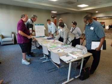
5 Timeline January February Countywide Survey 850+ respondents 4 Community Open Houses May Community Land Use Workshop June Community Open House Future Land Use Map January August 10 Committee Meetings, Drafting of Plan August October Plan Editing October 4 Introduction to Planning Commission Today s Workshop Next Steps 30-Day Public Comment Period, Public Hearing, and Planning Commission Vote to Consider. After which, review by Infrastructure and Regulation Committee and County Council Written Comments 5

6 Public Input Guiding Plan Website Press Releases December 21, 2017 January 17, 2018 June 7, 2018 October 19, Quarterly Enewsletters Postcards 400 to religious institutions Flyers Libraries, Recreation, and Senior Centers Mailers 200+ initially and another round going out Facebook Posts 70+ posts Listserv 164 opted in, plus 200 more added Advertised Public Hearing and Comment Period Notice 6
7 Vision Statement Horry County will sustain and enhance the quality of life for our residents and visitors by fostering healthy and safe communities, preserving our natural assets and rural heritage, encouraging business growth and economic diversification, and providing services and public facilities that will protect and strengthen our future. 7
8 Protect the health, safety, and welfare of residents and visitors by Overarching Goals COMMUNITY FACILITIES AND SERVICES COMMUNITY FACILITIES AND SERVICES COMMUNITY CHARACTER Coordinate growth and infrastructure improvements to efficiently Coordinate growth and infrastructure improvements to efficiently Promote a sense of place within our existing and emerging ENVIRONMENTAL and equitably meet SUSTAINABILITY the public facility and service needs of our and equitably meet the public facility and service needs of our communities by preserving and cultivating their unique character Encourage existing and and future incentivize populations. sustainable development activities existing and future populations. and identities. that minimize and mitigate the impact on the natural environment and MOBILITY avoid adverse AND impacts TRANSPORTATION on existing development. MOBILITY AND TRANSPORTATION RURAL PRESERVATION Promote development patterns and fund infrastructure projects Promote development patterns and fund infrastructure projects Preserve rural areas and lifestyles, along with natural resources ECONOMIC that result in GROWTH well-integrated and maintained transportation that result in a well-integrated and maintained transportation and assets, through land use decisions and policies. Develop system. a more diversified and resilient economy that supports system. COMMUNITY CHARACTER the recruitment and retention of of businesses, encourages new Promote a sense of place within our existing and emerging REVITALIZATION, REDEVELOPMENT, AND INFILL investments, ENVIRONMENTAL capitalizes SUSTAINABILITY and expands upon our existing niches, Encourage communities and by preserving support and community cultivating their revitalization, unique character Encourage and incentivize sustainable development of activities and ultimately results in greater economic stability of our residents redevelopment, and identities. and infill development that stabilizes and that minimize and mitigate the impact on the natural environment and local businesses. improves property values, promotes additional reinvestment, and and avoid adverse impacts on existing development. enhances RURAL quality PRESERVATION of life for our residents. COMMUNITY ENGAGEMENT Preserve rural areas and lifestyles, along with natural resources Create ECONOMIC an environment GROWTH in which residents, businesses, and other and assets, through land use decisions and policies. Develop a more diversified and resilient economy that supports HEALTHY, LIVABLE COMMUNITIES stakeholders are engaging and informed of planning efforts, the recruitment and retention of businesses, encourages new Foster the development of healthy, livable communities in which regulatory changes, infrastructure projects, and volunteer and residents REVITALIZATION, and visitors alike have REDEVELOPMENT, access to a variety AND of housing INFILL investments, capitalizes and expands upon our existing niches, and partnership opportunities. Encourage and support community revitalization, and ultimately results in greater economic stability of our residents transportation options, facilities and services, culture and arts, and redevelopment, and infill development that stabilizes and and local businesses. recreational and natural assets. improves property values, promotes additional reinvestment, and enhances quality of life for our residents. SAFE COMMUNITIES Protect the health, safety, and welfare of residents and visitors by HEALTHY, LIVABLE COMMUNITIES providing adequate public safety facilities and services, enforcing Foster the development of healthy, livable communities which and improving regulations, and minimizing incompatible land residents and visitors alike have access to a variety of housing and uses. transportation options, facilities and services, culture and arts, and recreational and natural assets. COMMUNITY FACILITIES AND SERVICES Coordinate SAFE growth COMMUNITIES and infrastructure improvements to efficiently and equitably Protect the meet health, the safety, public and facility welfare and of service residents needs and of visitors our by SAFE SAFE COMMUNITIES COMMUNITIES Protect the health, safety, and welfare of residents and visitors by providing adequate public safety facilities and services, enforcing providing adequate public safety facilities and services, enforcing and improving regulations, and minimizing incompatible land and improving regulations, and minimizing incompatible land uses. uses. COMMUNITY ENGAGEMENT Create an environment in which residents, businesses, and other stakeholders are engaging and informed of planning efforts, regulatory changes, infrastructure projects, and volunteer and partnership opportunities. 8

9 Population Element 700, , , , , , , , , , ,291 69, ,629 39,376 59,820 26, ,053 68,247 32,077 51, , Population Projection 9


10 Cultural Resources Element 10


11 Natural Resources Element 11

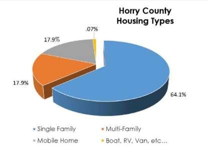
12 Housing Element 12

13 Community Facilities Element 13

14 Public Safety Element Many departments/offices having the same future needs. Co-locate services on the same site. Critical facilities need to be located outside the 500 year floodplain. County needs a Master Plan for all facilities both safety and community. 14

15 Transportation Element Existing Road Network Horry County 1,464 miles 864 paved and 600 unpaved SCDOT 1,338 miles US Highways 223 miles Desire for a Complete Streets Network 15


16 Economic Development Element Employment by Industry 16


17 Priority Investment Element FY2019 Revenues $28,262,416 FY2019 Expenditures $28,262,416 17

18 Future Land Use Map & Definitions
19 Guiding Factors Community Character Revitalization, Redevelopment and Infill Healthy, Livable Communities Safe Communities Mobility and Transportation Environmental Sustainability Economic Growth Community Facilities and Services Rural Preservation 19

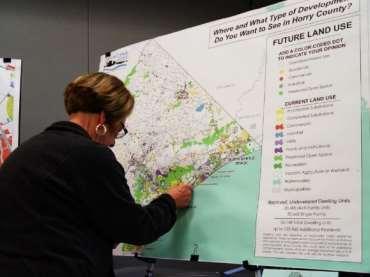
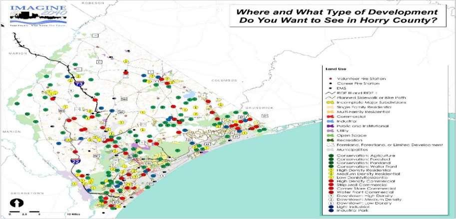
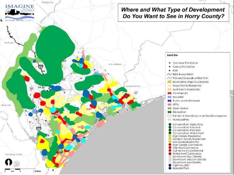

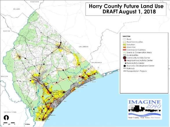
20 Developing the Future Land Use Map 20


21 Scenic & Conservation Area Definition Environmentally sensitive and scenic areas, such as Carolina Bays, estuarine and forested wetlands, undeveloped beachfront, forestlands, floodplains, agricultural lands, and natural recreational and open spaces. Limited development. If developed, design should use low impact designs principles to support environmental preservation and avoid natural hazards. Subdivision into less than 5 acres is discouraged. Should be considered for Open Space in Urban and Suburban areas.


22 Scenic & Conservation Area Definition Primary Land Uses: Open space, nature-based recreation, timberland, agriculture and agricultural/forestry support uses. Secondary Land Uses: Permanent and temporary educational and research facilities, eco-tourism and agritourism operations. Conditional Uses: Mining, outdoor shooting ranges, campgrounds.

23 Scenic & Conservation Area Definition Written Comments


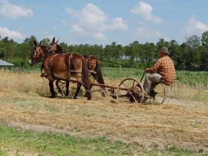
24 Rural Definition Rural areas should support the preservation of farmland and prime agricultural soils, in addition to the preservation of other natural resources, scenic views, and cultural and historic resources. Development should retain the rural character. Commercial development and services are allowable in Rural Activity Centers. Subdivision for residential is allowed with minimum lot size of ½ acre.


25 Rural Definition Primary Land Uses: Agriculture, timberland, and their support uses and services, including, but not limited to crop and livestock processing facilities, stables, veterinary services and farm equipment sales. Single-family detached houses, including mobile homes, on individual large lots. Secondary Land Uses: Agritourism and eco-tourism uses. Conditional Land Uses: Rural amusement, outdoor shooting ranges, campgrounds, and mining operations.
26 Rural Areas Written Comments


27 Rural Communities Definition Single family residential areas that have historically grown at a higher density than surrounding Rural Areas. Located in close proximity to municipalities or have grown organically over time. Individual single family lots are encouraged as long as they coincide with the existing density and character of the community. Subdivision allowed with minimum lot size of 14,500 sq ft or 3 units per gross acre. Commercial uses and services along major arterial roadways and along SCDOT business routes, where appropriate.


28 Rural Communities Definition Primary Land Uses: Single family detached houses, including mobile homes, individual lots or within subdivisions. Secondary Land Uses: Neighborhood commercial uses and tradeshops. Conditional Land Uses: Rural amusement, campgrounds, mobile home parks.
29 Rural Communities Written Comments


30 Rural Activity Center Definition Provides opportunities at major rural crossroads for commercial development and services. This includes small feed stores, restaurants, convenience grocery markets, and similar smaller scale retail uses and services. Residential uses are not encouraged within these activity Centers in order to preserve these areas for economic activity. 1/8 mile radius and be ¼ mile across. In cases where there are environmental constraints, impacts to these areas should be avoided.


31 Rural Activity Center Definition Primary Land Uses: Feed stores, restaurants, convenience stores, gasoline and automobile service stations, and produce stands. Secondary Land Uses: Grocery and general stores, auto and farm equipment sales, tradeshops, and other commercial uses. Conditional Land Uses: Rural amusement, ecotourism and agritourism operations, campgrounds.
32 Rural Activity Center Written Comments


33 Suburban Definition Mixture of housing types and suburban densities, providing a transition from low-density rural communities to more intense high-density urban environments. Support healthy lifestyles through active recreation, open space, bicycle and pedestrian access, and walkable block lengths. Multi-family developments are encouraged near Neighborhood Activity Centers, within Community Activity Centers, and where there is adequate road capacity and potential for public transit options. Neighborhood and regional commercial uses and services are encouraged at Activity Centers. Smaller commercial uses and services are allowed along major arterial roadways, SCDOT business and bypass routes, and Commercial Corridors if compatible with the community and the property is adequately sized.


34 Suburban Definition Primary Land Uses: Single family detached houses, duplexes, townhomes. Secondary Land Uses: Multi family development and condos. Commercial uses, services, and professional offices. Conditional Land Uses: Outdoor Amusement and resort uses.
35 Suburban Areas Written Comments


36 Neighborhood Activity Center Definition Should provide the commercial and institutional uses necessary to support the common day to-day demands of the surrounding neighborhood. Grocery store shopping center will normally be the principal establishment. Include medical offices, restaurants, coffee shops, dry cleaners, small banking facilities, and other convenience retail. ¼ mile radius and are up to ½ wide.


37 Neighborhood Activity Center Definition Primary Land Uses: Grocery store, restaurant, bar, personal service, professional office, financial institution, small format medical office, personal service, drug store, drive through restaurants, convenience stores, gasoline stations, and smaller scale retail shopping. Secondary Land Uses: Multi family housing, amusement, storage facilities. Conditional Land Uses: Tradeshops and other uses that require outdoor storage and repair.
38 Future Land Use: Neighborhood Activity Center Written Comments


39 Commercial Corridor Definition Commercial corridors include arterial roadways that have historically developed with commercial, office, and service uses. They do not include established single family residential subdivisions that may back up to the corridor. May provide a vertical and horizontal mix of suburban scale retail, commercial, office, residential, and institutional land uses. Punctuated by higher intensity development located at Activity Centers and Mixed Use Areas where the highest intensity and integration of uses occurs. Opportunities for infill and redevelopment that organize uses in a pedestrian friendly format with sidewalks and landscaping.


40 Commercial Corridor Definition Primary Land Uses: Retail shopping, drug stores, restaurants and bars, drive through restaurants, convenience stores and gasoline stations, automobile sales, professional offices, financial institutions, medical offices, personal services. Secondary Land Uses: Hotels and amusement activities. Services, storage, and light industrial. Conditional Land Uses: Townhomes and multi-family developments are appropriate along the corridor, but are preferably developed within Mixed Use areas and Community Activity Centers.
41 Commercial Corridor Written Comments


42 Mixed Use Definition Mixed use areas should provide a vertical and horizontal mix of retail, commercial, office, moderate to high density residential, and institutional land uses. Open spaces and parks are also important uses within Mixed Use Areas and often serve as focal points of major developments. Grid and modified grid development patterns with short block lengths are preferred over curvilinear and cul-de-sac designs to support interconnectivity, walkability, and pedestrian scale development. Residential greater than 7 units per gross acre near Community Activity Centers. Residential less than 7 units per gross acre is located along the fringe of Mixed Use areas.


43 Mixed Use Definition Primary Land Uses: Resorts, hotels, dense multi family housing, professional offices, restaurants and bars, financial institutions, medical offices, personal services, drug stores, large and small scale retail shopping. Secondary Land Uses: Single-family, detached and attached, drive through restaurants, convenience stores and gasoline stations. Conditional Land Uses: Light industrial and tradeshops.
44 Mixed Use Written Comments

 and horizontally mixed, with ground")

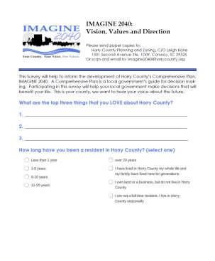
45 Community Activity Center Definition Should include an integrated mix of commercial (shopping, services), office, and residential uses, arranged in a walkable pattern with an active pedestrian realm where buildings front streets. Center may include both vertically (within multi-story buildings) and horizontally mixed, with ground floor retail and offices and housing on upper floors Centers are located within 1/2 mile of the crossroads with a total width being up to 1 mile across. Traditional grid pattern fashion and be focused on outdoor civic space. The center should be surrounded by residential areas that support the inner core


46 Community Activity Center Definition Primary Land Uses: Large and small format retail centers and shops, grocery stores, restaurants, bars, personal services, multifamily housing located above non residential uses on the ground floor, and public gathering spaces such as plazas. Secondary Land Uses: Stand alone multi family housing, professional offices, and other commercial uses, including amusement, entertainment, and tourism related uses. Conditional Land Uses: Light industrial and tradeshops.
47 Future Land Use: Community Activity Center Written Comments


48 Economic Development Center Definition Concentrated areas of high quality employment facilities, adjacent to complementary retail and commercial uses and/or residential uses. Encourages development of manufacturing, industrial, distribution, services, and office uses in locations that will minimally affect surrounding properties. Commercial uses are secondary to major employment uses. Residential should be greater than 7 units per acre in order to preserve these areas for economic growth. Railroad corridor should be preserved for industrial uses.

49 Economic Development Center Definition Primary Land Uses: Manufacturing, warehousing and logistics centers, light and heavy industrial, research and development facilities, business parks, and other major employers. Secondary Land Uses: Personal service, financial institution, small format medical office, personal service, drug store, smaller scale retail shopping, and restaurants. Resorts, large sports tourism or amusement facilities, and other commercial uses, such as drive through restaurants, convenience stores and gasoline stations, are more appropriately located near highway interchanges. Conditional Uses: Multi family housing, schools, and other uses that may inhibit the development of these sites for major economic development initiatives.
50 Economic Development Center Written Comments
51 Protect the health, safety, and welfare of residents and visitors by providing adequate public safety facilities and services, enforcing and improving regulations, and minimizing incompatible land uses. Goals, Objectives, and COMMUNITY Strategies FACILITIES AND SERVICES Coordinate growth and infrastructure improvements to efficiently existing and future populations. COMMUNITY CHARACTER COMMUNITY Promote a sense CHARACTER of place within our existing and emerging ENVIRONMENTAL MOBILITY AND TRANSPORTATION SUSTAINABILITY Promote communities a sense by preserving of place and within cultivating our existing their unique and emerging character ENVIRONMENTAL Encourage Promote development and incentivize SUSTAINABILITY patterns sustainable and fund development infrastructure activities projects communities by preserving and cultivating their unique character Encourage and incentivize sustainable development activities and identities. that that minimize result and in a mitigate well-integrated the impact and on maintained the natural environment transportation and identities. that and minimize and mitigate the impact on the natural environment system. avoid adverse impacts on existing development. and avoid adverse impacts on existing development. RURAL COMMUNITY PRESERVATION CHARACTER RURAL Preserve Promote PRESERVATION rural areas a sense and of lifestyles, place within along our with existing natural and resources emerging ECONOMIC ENVIRONMENTAL GROWTH SUSTAINABILITY Preserve and assets, communities rural through areas by land and preserving use lifestyles, decisions and along cultivating and with policies. natural their unique resources character ECONOMIC Develop Encourage a more GROWTH and diversified incentivize and sustainable resilient economy development that activities supports and assets, and identities. through land use decisions and policies. Develop a more diversified and resilient economy that supports the that recruitment minimize and and mitigate retention the impact of businesses, the natural encourages environment new the recruitment and avoid adverse and retention impacts on of existing businesses, development. encourages new REVITALIZATION, REDEVELOPMENT, AND INFILL investments, capitalizes and expands upon our existing niches, REVITALIZATION, REDEVELOPMENT, AND INFILL investments, capitalizes and expands upon our existing niches, Encourage RURAL PRESERVATION and support community revitalization, and ultimately results in greater economic stability of our residents Encourage Preserve and rural areas support and lifestyles, community along with revitalization, natural resources and ultimately ECONOMIC results GROWTH in greater economic stability of our residents redevelopment, and infill development that stabilizes and and local businesses. redevelopment, and assets, and through infill land development use decisions and that policies. stabilizes and and local Develop businesses. a more diversified and resilient economy that supports improves property values, promotes additional reinvestment, and improves property values, promotes additional reinvestment, and the recruitment and retention of businesses, encourages new enhances quality of life for our residents. COMMUNITY ENGAGEMENT enhances REVITALIZATION, quality of life for our REDEVELOPMENT, residents. AND INFILL investments, capitalizes and expands upon our existing niches, COMMUNITY Create an environment ENGAGEMENT in which residents, businesses, and other Encourage and support community revitalization, Create and an ultimately environment results in in which greater residents, economic businesses, stability of and our residents other HEALTHY, LIVABLE COMMUNITIES stakeholders are engaging and informed of planning efforts, HEALTHY, redevelopment, LIVABLE COMMUNITIES and infill development that stabilizes and stakeholders and local are businesses. engaging and informed of planning efforts, Foster the development of healthy, livable communities in which regulatory changes, infrastructure projects, and volunteer and Foster improves the development property values, of healthy, promotes livable additional communities reinvestment, which and regulatory changes, infrastructure projects, and volunteer and residents and visitors alike have access to a variety of housing and partnership opportunities. residents enhances and visitors quality alike of have life for access our residents. to a variety of housing and partnership COMMUNITY opportunities. ENGAGEMENT transportation options, facilities and services, culture and arts, and transportation options, facilities and services, culture and arts, and Create an environment in which residents, businesses, and other recreational and natural assets. recreational HEALTHY, and natural LIVABLE assets. COMMUNITIES stakeholders are engaging and informed of planning efforts, Foster the development of healthy, livable communities in which regulatory changes, infrastructure projects, and volunteer and SAFE residents COMMUNITIES and visitors alike have access to a variety of housing and SAFE COMMUNITIES partnership opportunities. Protect the health, safety, and welfare of residents and visitors by Protect transportation the health, safety, options, and facilities welfare and of services, residents culture and visitors and arts, by and providing adequate public safety facilities and services, enforcing providing recreational adequate and public natural safety assets. facilities and services, enforcing and improving regulations, and minimizing incompatible land and improving regulations, and minimizing incompatible land uses. uses. SAFE COMMUNITIES Protect the health, safety, and welfare of residents and visitors by COMMUNITY providing adequate FACILITIES FACILITIES public AND AND safety SERVICES SERVICES facilities and services, enforcing Coordinate Coordinate and improving growth growth and and regulations, infrastructure infrastructure and improvements improvements minimizing incompatible to to efficiently efficiently land and equitably uses. meet meet the the public public facility facility and and service service needs needs of of our our existing and future populations. COMMUNITY FACILITIES AND SERVICES Coordinate growth and infrastructure improvements to efficiently MOBILITY and equitably AND TRANSPORTATION meet the public facility and service needs of our and equitably meet the public facility and service needs of our 51

52 Announcements Public Hearing December 6th Public Comments through November
53 For More Information: IMAGINE 2040 Webpage Leigh Kane, AICP - Principal Planner Comments: IMAGINE2040@horrycounty.org 53
Planning Commission Workshop. November 29, 2018
 Planning Commission Workshop November 29, 2018 Composition of Committee Steven Neeves, Chair Marvin Heyd, Vice-Chair Joe Burch Pam Creech Ruth Anne Ellis Rick Elliott Christy Everett Chris Hennigan Kimberly
Visioning Statement and Guiding Principles
 Visioning Statement and Guiding Principles Planning for the Future The General Plan The General Plan represents Woodland's shared vision of the future and defines a path to lead the community toward its
CHAPTER 3 VISION, GOALS, & PLANNING PRINCIPLES. City of Greensburg Comprehensive Plan. Introduction. Vision Statement. Growth Management Goals.
 CHAPTER 3 VISION, GOALS, & PLANNING PRINCIPLES Introduction The Greensburg Comprehensive Plan is intended as a working community document. A combination of long and short-term goals, this document is intended
Plano Tomorrow Vision and Policies
 Plano Tomorrow Vision and Policies PLANO TOMORROW PILLARS The Built Environment The Social Environment The Natural Environment The Economic Environment Land Use and Urban Design Transportation Housing
CITY OF CLAREMONT MASTER PLAN 2017 CHAPTER 1: LAND USE
 CITY OF CLAREMONT MASTER PLAN CHAPTER 1: LAND USE Prepared by the Claremont Planning Board and the Claremont Planning and Development Department Vision Claremont Master Plan Chapter 1: Land Use Claremont
Implementation Guide Comprehensive Plan City of Allen
 Implementation Guide 2030 Comprehensive Plan City of Allen DRAFT 2015 Implementation Guide Allen 2030 Comprehensive Plan INTRODUCTION The Comprehensive Plan serves as a guide for the growth and development
Broken Arrow Comprehensive Plan Update Public Workshop Meeting #3 January 23,
 Broken Arrow Comprehensive Plan Update Public Workshop Meeting #3 January 23, September 25,2018 2018 26 April 2016 AGENDA 1. Status Presentation - Charrette Recap - Proposed Vision Framework - Preliminary
ELK GROVE GENERAL PLAN VISION
 2-1 CHAPTER 2: 2-2 CREATING OUR The Community Vision for Elk Grove, expressed through a Vision Statement and a series of Supporting Principles, is a declaration of the kind of community that Elk Grove
FUTURE DEVELOPMENT AREAS
 FUTURE DEVELOPMENT AREAS Refer to the Future Development Map on Page 2. Suburban Residential (Less than 3 units/acre) Suburban Residential neighborhoods form the backbone of Smyrna. While growth and redevelopment
S A C R A M E N T O C O U N T Y JACKSON HIGHWAY & GRANT LINE EAST VISIONING STUDY
 JACKSON HIGHWAY & GRANT LINE EAST S A C R A M E N T O C O U N T Y P L A N N I N G D E P A R T M E N T SUMMARY AND WORKBOOK November 19, 2008 History of the Visioning Study Sacramento County has two growth
CHAPTER 2: PLANNING PRINCIPLES
 CHAPTER 2: PLANNING PRINCIPLES 2 Comprehensive Principles The following overarching Principles provide the basis for the goals and policies included in the Mendocino County General Plan. These Principles
Proposed Comprehensive Plan Strategies DRAFT for discussion June 28, 2017
 Proposed Comprehensive Plan Strategies DRAFT for discussion June 28, 2017 Land Use Rural Areas Refine the Farm and Forest area (FF) Update FF boundaries to account for existing lots less than five acres
Staff Report and Recommendation
 Community Planning and Development Planning Services 201 W. Colfax Ave., Dept. 205 Denver, CO 80202 p: 720.865.2915 f: 720.865.3052 www.denvergov.org/cpd TO: City Council Neighborhoods and Planning Committee
Town Center (part of the Comprehensive Plan)
") Town Center (part of the Comprehensive Plan) Mercer Island Town Center Looking North (2014) In 1994, a year-long process culminated in a set of design guidelines and code requirements for the Town Center
Town Center (part of the Comprehensive Plan) Mercer Island Town Center Looking North (2014) In 1994, a year-long process culminated in a set of design guidelines and code requirements for the Town Center
EXECUTIVE SUMMARY DRAFT CHAPTER 1 INTRODUCTION EXECUTIVE SUMMARY
 CHAPTER 1 EXECUTIVE SUMMARY INTRODUCTION Through the joint efforts of the City of Tulsa planning staff and the Land Services division of Indian Nations Council of Governments (INCOG), the Berryhill Land
REGIONAL ACTIVITY CENTER
 DRAFT REGIONAL ACTIVITY CENTER 70 EAST BENCH MASTER PLAN DRAFT 06 Introduction The East Bench Regional Activity center is comprised of large educational, research, medical, and employment centers. These
Silverdale Regional Center
 Silverdale Regional Center Vision for Silverdale Regional Center The Silverdale Regional Center Plan (Plan) will guide the evolution of the Silverdale Regional Center from a collection of strip malls and
What s in a Name Sustainability, Smart Growth, New Urbanism
 What s in a Name Sustainability, Smart Growth, New Urbanism Published in the Summer 2011 Issue of APA s The Commissioner Pete Pointner FAICP Planning commissioners frequently hear abstract terms bantered
Silver Line CPAM UPDATE. Transportation and Land Use Committee October 14, 2016
 Silver Line CPAM UPDATE Transportation and Land Use Committee October 14, 2016 Purpose Recap Project History and Map Changes Provide Overview of CPAM Components Discuss Transportation Impacts Discuss Fiscal
Urban Planning and Land Use
 Urban Planning and Land Use 701 North 7 th Street, Room 423 Phone: (913) 573-5750 Kansas City, Kansas 66101 Fax: (913) 573-5796 Email: planninginfo@wycokck.org www.wycokck.org/planning To: From: City Planning
OVERARCHING GOALS OF PLAN
 11.27.2018 Draft VISION STATEMENT Horry County will sustain and enhance the quality of life for our residents and visitors by fostering healthy and safe communities, preserving our natural assets and rural
DOMINION BOULEVARD CORRIDOR STUDY AND ECONOMIC DEVELOPMENT STRATEGIC PLAN A MODEL FOR CHESAPEAKE S FUTURE
 DOMINION BOULEVARD CORRIDOR STUDY AND ECONOMIC DEVELOPMENT STRATEGIC PLAN A MODEL FOR CHESAPEAKE S FUTURE Overview I. Draft Plan Process II. Draft Plan Overview a. Market Analysis b. Master Land Use Plan
SAN RAFAEL GENERAL PLAN 2040 INTRODUCTION AND OVERVIEW
 SAN RAFAEL GENERAL PLAN 2040 INTRODUCTION AND OVERVIEW Steering Committee Presentation February 14, 2018 Purpose of General Plan Guide land use and development decisions Coordinate transportation, infrastructure,
PINE CURVE REZONING. Property does not meet criteria for open space preservation and is not a candidate for a park
 PINE CURVE REZONING BACKGROUND Purchased as two parcels in 2001 and 2002 Annexed and Zoned Greater Downtown District Historic Center September 25, 2002 and October 7, 2002 WHAT THE PROJECT IS AND IS NOT
The Five Components of the McLoughlin Area Plan
 The Five Components of the McLoughlin Area Plan This documents contains the complete language of the five components of the McLoughlin Area Plan: The Vision Statement The Values The Guiding Principles
D-O LRT Zoning Discussion. Chapel Hill Boards & Commissions October 16, 2017
 D-O LRT Zoning Discussion Chapel Hill Boards & Commissions October 16, 2017 Update on Overall D-O LRT Station Area Initiative Objectives Design and educate on principles of Good Transit-Oriented Development
FUNDING CORRIDOR REVITALIZATION
 FUNDING CORRIDOR REVITALIZATION Integrated corridor planning for the 21 st Century America Planning Association Annual Conference Atlanta, GA April 27, 2014 Mariia Zimmerman, MZ Strategies, LLC mariia@mzstrategies.com
PINE CURVE REZONING. BACKGROUND Purchased as two parcels in 2001 and 2002
 BACKGROUND Purchased as two parcels in 2001 and 2002 WHAT THE PROJECT IS AND IS NOT A Rezoning establishes the land use standards for Annexed and Zoned Greater Downtown District Historic Center September
Dwelling Units Max 12 dwelling units per acre/min 8 dwelling units per acre. Development Mix 80% non residential/20% residential
 13. OSTEEN LOCAL PLAN Background: The Osteen Local Plan area is located in southwest Volusia County along the SR 415 corridor between Lemon Bluff Road and Acorn Lake Road and includes 3,990 acres. The
implementation10 Village of Greendale Comprehensive Plan: Greendale, Wisconsin. Revisiting a Greenbelt Community
 implementation10 Village of Greendale Comprehensive Plan: 2010 - Village of Greendale Comprehensive Plan: 2010 - Implementation The recommendations of this Plan must be implemented by the Village of Greendale,
SECTION II SECTION II STATEMENT OF GOALS, OBJECTIVES, PRINCIPLES, ASSUMPTIONS, POLICIES AND STANDARDS
 STATEMENT OF GOALS, OBJECTIVES, PRINCIPLES, ASSUMPTIONS, POLICIES AND STANDARDS 1 2 STATEMENT OF GOALS, OBJECTIVES, PRINCIPLES, ASSUMPTIONS, POLICIES AND STANDARDS INTRODUCTION The New Jersey Municipal
PSRC REVIEW REPORT & CERTIFICATION RECOMMENDATION
 PSRC REVIEW REPORT & CERTIFICATION RECOMMENDATION KITSAP COUNTY COUNTYWIDE PLANNING POLICIES July 2, 2012 BACKGROUND A major emphasis of the Washington State Growth Management Act (GMA) is the need to
FUTURE LAND USE ELEMENT
 FUTURE LAND USE ELEMENT GOAL I: To create and sustain a great place to live, play, and prosper Objective 1: The City of Ocala shall incorporate the principles and strategies of the Ocala 2035 Vision into
CITY OF PUYALLUP. Background. Development Services
 CITY OF PUYALLUP Development Services 333 South Meridian Puyallup WA 98371 To: City Council From: Katie Baker, AICP, Planning Division Re: South Hill Neighborhood Plan Adoption Date: (Meeting date: February
2040 LUP is a part of the Comprehensive Plan and carries the same legal authority. Economic Challenges
 1.1. Guiding Anchorage s Growth Where will new residents settle over the next two decades? Where will people work, shop, and play? Will there be enough room to grow? How will Anchorage look? Will growth
Anatomy of A Vibrant Downtown. Anatomy of a Vibrant Downtown
 Anatomy of A Vibrant Downtown The goal of MAIN ST. REVITALIZATION PLANNING is to provide a framework that will help transform your downtown into a VIBRANT DOWNTOWN a place where people love to LIVE, WORK,
North Fair Oaks Community Plan Summary and Information
 North Fair Oaks Community Plan Summary and Information WHAT IS THE NORTH FAIR OAKS COMMUNITY PLAN? The North Fair Oaks Community Plan is part of the San Mateo County General Plan, and establishes policies
A BLUEPRINT FOR BROCKTON A CITY-WIDE COMPREHENSIVE PLAN
 A BLUEPRINT FOR BROCKTON A CITY-WIDE COMPREHENSIVE PLAN Public Meeting October 2016 1 Plan Summary and Discussion Public Meeting May 4 2017 City of Brockton Bill Carpenter, Mayor Department of Planning
4.1.3 LAND USE CATEGORIES
 4.1.3 LAND USE CATEGORIES a. City Center District The City Center District incorporates the existing character and mix of uses in downtown Belmont to encourage redevelopment and new development in keeping
East Bench Master Plan Update
 Community & Economic Development Office of the Director East Bench Master Plan Update To: From: Planning Commission Wayne Mills, Senior Planner Date: November 18, 2015 CC: Re: Nora Shepard, City Planning
THEMES, VISION, + PRINCIPLES
 CHAPTER 2: THEMES, VISION, + PRINCIPLES This page intentionally left blank. 20 VISION DRAFT AUGUST 2018 2 2 THEMES, VISION, + GUIDING PRINCIPLES The Key Themes, Vision, and Guiding Principles presented
4-Town Comprehensive Plan DRAFT 7/30/07
 4-Town Comprehensive Plan DRAFT 7/30/07 Acknowledgements ning Committee Town of Harrisburg Norman Roof Randy Nicol Town of Martinsburg Terry Thisse Paul Kelly Town of Montague Jan Bagdanowicz Wendy Perry
Lehigh Acres Land Development Regulations Community Planning Project
 Lehigh Acres Land Development Regulations Planning Effort Summary In July, 2010 Commissioner Frank Mann invited the Lehigh Acres community to start discussing how to achieve their recently adopted community
West Ocala Vision & Community Plan City Council Work Session. Presented by West Ocala Community Plan Steering Committee
 West Ocala Vision & Community Plan City Council Work Session Presented by West Ocala Community Plan Steering Committee November 29,2011 Ocala 2035 Vision West Ocala Community Vision & Master Plan West
Port Lavaca Future Land Use
 Port Lavaca Future Land Use Introduction The City of Port Lavaca is beginning to see sustained growth, after many years of relative stable population. New single family homes, apartments, and businesses
IMPLEMENTING SOMERSET COUNTY S INVESTMENT FRAMEWORK
 IMPLEMENTING SOMERSET COUNTY S INVESTMENT FRAMEWORK SMART CONSERVATION THROUGH SMART GROWTH NJ LAND CONSERVATION RALLY March 22, 2014 Laurette Kratina, PP, AICP, Supervising Planner Somerset County Planning
City of Tacoma Planning and Development Services
 Agenda Item E-1 City of Tacoma Planning and Development Services To: Planning Commission From: Elliott Barnett, Planning Services Division Subject: Tacoma Mall Regional Center Subarea Plan and EIS Meeting
Official Plan Review
 Official Plan Review Summary Report - The Built Environment August 2014 Part 1: Introduction Planning for a healthy, prosperous and sustainable community is an important goal for our municipality. From
Chapter 1.0 Introduction
 Chapter 1.0 Introduction 1.1 Background The North Metro commuter rail line is part of the RTD FasTracks regional transit system expansion program to build more than 100 miles of rail transit throughout
Listening Sessions: Guiding Principles and Unified Development Code New Castle County, Delaware
 Listening Sessions: Guiding Principles and Unified Development Code New Castle County, Delaware March 2015 AGENDA Introduction: Who We Are Work Program and Schedule Guiding Principles Discussion Project
Economic Development & Housing Council Committee Comprehensive Plan Update September 20, 2005
 1 Economic Development & Housing Council Committee Comprehensive Plan Update September 20, 2005 Purpose To update the Committee on the ForwardDallas! Plan, including: Status Anticipated Products Public
Municipal Development Plan Update Urban Service Area and Hamlets
 ENCLOSURE 1 Municipal Development Plan Update Urban Service Area and Hamlets Priorities Committee January 24, 2017 MUNICIPAL DEVELOPMENT PLAN UPDATE SHAPING OUR FUTURE MDP Update - Agenda MDP Update Public
Further input invited as Colchester Growth Strategy nears final phase
 IUE 3 / NOVEMBER 2015 Further input invited as Colchester Growth trategy nears final phase trathcona County is seeking public feedback as it enters the final phase of work on a Growth Management trategy
STAFF SUMMARY FOR S17-02 SPECIAL USE PERMIT APPLICATION
 APPLICATION SUMMARY Case Number: S17-02 Request: STAFF SUMMARY FOR S17-02 SPECIAL USE PERMIT APPLICATION SUP application in order to develop a convenience food store. Applicant: Property Owner(s): Cindee
OVERVIEW OF PLANS FOR THE JEFFERSON COUNTY COUNTRYSIDE FARM In the Context of Quality Place Characteristics
 OVERVIEW OF PLANS FOR THE JEFFERSON COUNTY COUNTRYSIDE FARM In the Context of Quality Place Characteristics By Steve Grabow, Professor and Community Development Educator University of Wisconsin-Extension,
Planning Commission April 4, 2013 BOCC Workshop Page 1
 Planning Commission April 4, 2013 BOCC Workshop Page 1 Planning Commission April 4, 2013 BOCC Workshop Page 2 Planning Commission April 4, 2013 BOCC Workshop Page 3 Planning Commission April 4, 2013 BOCC
Gold Line Bus Rapid Transit Transit Oriented Development (BRTOD) Helmo Station Area Plan
 Helmo Station Area Plan") Appendix F Gold Line Bus Rapid Transit Transit Oriented Development (BRTOD) Helmo Station Area Plan Introduction and Purpose of the Plan The Gold Line Bus Rapid Transit facility is an eleven-mile dedicated
Appendix F Gold Line Bus Rapid Transit Transit Oriented Development (BRTOD) Helmo Station Area Plan Introduction and Purpose of the Plan The Gold Line Bus Rapid Transit facility is an eleven-mile dedicated
1.0 Purpose of a Secondary Plan for the Masonville Transit Village
 Report to Planning and Environment Committee To: Chair and Members Planning & Environment Committee From: John M. Fleming Managing Director, Planning and City Planner Subject: Masonville Transit Village
Planning Charlotte s Future. Planning Committee June 21, 2016
 Planning Charlotte s Future Planning Committee June 21, 2016 Charlotte s Vision Livable city Vibrant economy Thriving natural environment Diverse population Choices for housing, education, employment Safe
Robbinsdale LRT Station. CDI Development Guidelines. August Overview
 Robbinsdale LRT Station August 2018 Overview The City of Robbinsdale may have the coolest opportunity site along the 13 mile stretch of the Bottineau LRT corridor / Blue Line extension. Located a block
JANUARY 19, 2011 CENTRAL AVENUE-METRO BLUE LINE TRANSIT-ORIENTED DEVELOPMENT IMPLEMENTATION PROJECT COMMUNITY FORUM
 CENTRAL AVENUE-METRO BLUE LINE TRANSIT-ORIENTED DEVELOPMENT IMPLEMENTATION PROJECT COMMUNITY FORUM JANUARY 19, 2011 THE MARYLAND-NATIONAL CAPITAL PARK AND PLANNING COMMISSION PRINCE GEORGE S COUNTY PLANNING
CHAPTER 3. Growth Management
 CHAPTER 3 Growth Management Photo courtesy of J. Sinclair Photography/Visit Winston-Salem Chapter 3. Growth Management Plan Goal: Manage growth and development to reduce sprawl, create a more compact and
TOWN COUNCIL / PLANNING COMMISSION
 Workshop #3 TOWN COUNCIL / PLANNING COMMISSION January 20, 2011 Consultant Team In Attendance Tonight BMS Design Group Nevada City and San Francisco Michael Smiley, AICP, ASLA Partner-in-Charge Nancy L.
4- PA - LD - LIVELY DOWNTOWN. LD - Background
 4- PA - LD - LIVELY DOWNTOWN LD - Background The downtown has been the service centre for the community since the city s inception and the area continues to supply people with their personal services,
Market Demand and Land Use
 Market Demand and Land Use Summary 57 Challenges 60-61 Guiding Principles 62 Strategy and Implementation 63-69 Establish a mix of uses that contribute to a vibrant downtown. 58 Summary Historically, downtown
Living in Albemarle County s Urban Places
 Living in Albemarle County s Urban Places ALBEMARLE COUNTY, VIRGINIA A Closer Look at Albemarle s Approach to Managing Growth and Creating Quality Urban Environments www.albemarle.org Page 2 Living in
LAND USE ELEMENT. Purpose. General Goals & Policies
 LAND USE ELEMENT Purpose This Land Use Element contains the goals and policies necessary to support the City s responsibility for managing land resources and guiding development through implementing regulations,
This page intentionally blank.
 This page intentionally blank. Parks, Recreation, and Open Space Chapter Relationship to Vision Vision Parks, Recreation and Open Space Chapter Concepts County Government. County government that is accountable
IMPLEMENTATION STRATEGIES. In This Chapter. Goals & Strategies 182 Project List 183 Future Land Use 186 CHAPTER 11 IMPLEMENTATION STRATEGIES
 In This Chapter Goals & Strategies 182 Project List 183 Future Land Use 186 11 IMPLEMENTATION STRATEGIES NORTH AUGUSTA, SC 2017 COMPREHENSIVE PLAN 179 Individual commitment to a group effort that is what
Joint Meeting City Council and the Plan Commission. September 1st, 2015
 Joint Meeting City Council and the Plan Commission September 1st, 2015 1 The City Plan Commission shall recommend a City Plan for the physical development of the City Article IX Section 2 of the City of
Remi Mendoza City Planning Academy March 13, 2017
 Remi Mendoza City Planning Academy March 13, 2017 1 What is the General Plan? The 2030 General Plan 5-Year Update (2035 General Plan) Questions and Answers 2 Guidebook for development and growth Required
Planning Charlotte s Future. Transportation & Planning Committee March 14, 2016
 Planning Charlotte s Future Transportation & Planning Committee March 14, 2016 Charlotte s Vision Livable city Vibrant economy Thriving natural environment Diverse population Choices for housing, education,
Secrest Short Cut and Monroe Expressway Small Area Plan AUGUST 29, 2018
 Secrest Short Cut and Monroe Expressway Small Area Plan AUGUST 29, 2018 Background and Process Monroe Expressway will be open by the end of 2018 Union County and Indian Trail identified a need to revisit
THE TOWN OF WASAGA BEACH
 THE TOWN OF WASAGA BEACH Downtown Development Master Plan Committee of the Whole Presentation January 26 th 2017 Uses within this designation should reflect a dependence on tourism as opposed to the permanent
2035 General Plan Update and Belmont Village Specific Plan. Joint Study Session with the City Council and Planning Commission April 12, 2016
 2035 General Plan Update and Belmont Village Specific Plan Joint Study with the City Council and Planning Commission April 12, 2016 Agenda 1. Welcome and Introductions 2. General Plan Update Status of
Ivywild On The Creek PRELIMINARY CREEK DISTRICT MASTER PLAN
 Ivywild On The Creek PRELIMINARY CREEK DISTRICT MASTER PLAN Introduction: Rejuvenating an extraordinary Creekside neighborhood THE CREEKSIDE DISTRICT The Ivywild On The Creek Neighborhood District Master
APPENDICES DESIGNING PUBLIC SPACES - ENERGIZED PUBLIC SPACES DESIGN GUIDELINES WORKING DRAFT DECEMBER 2018 A1
 APPENDICES DESIGNING PUBLIC SPACES - ENERGIZED PUBLIC SPACES DESIGN GUIDELINES WORKING DRAFT DECEMBER 2018 A1 App.1 Case Studies by Park Types The upcoming (in-progress) online library will house several
Prosperity Hucks Area Plan. Transportation and Planning Committee May 11, 2015
 Prosperity Hucks Area Plan Transportation and Planning Committee May 11, 2015 Presentation Outline 1. Background and Location 2. Community Dialog Process 3. Activity Center Recommendations 4. Wedge Recommendations
PLANNING COMMISSION WORKSESSION AGENDA. City Hall Second Floor Conference Room 9027 Center Street. July 1, :30 PM
 MEMBERS Harry J. Clark, Chairperson Bruce Wood, Vice-Chairperson Russell Harrison Ken Johnson Robert W. Schilpp Martha Wilson PLANNING COMMISSION WORKSESSION AGENDA City Hall Second Floor Conference Room
Complete Neighbourhood Guidelines Review Tool
 Complete Neighbourhood Guidelines Review Tool Prepared By: City of Regina Planning Department October 2014 Page 1 of 14 Community Development Review Checklist for Secondary Plans and Concept Plans The
City of Royalton Comprehensive Land Use Plan 2005 to Revision February 8, 2011
 City of Royalton Comprehensive Land Use Plan 2005 to 2015 2011 Revision February 8, 2011 PART ONE: INTRODUCTION TO THE COMPREHENSIVE PLAN 1.0 Purpose and Introduction The Comprehensive Land Use Plan provides
Preliminary Plan Framework: Vision and Goals
 Preliminary Plan Framework: Vision and Goals Draft: May 2015 Introduction Since the Town of Milliken s comprehensive plan was last updated in 2010, the community was heavily impacted by the 2013 flood,
DALY CITY VISIONING PROCESS COMMUNITY WORKSHOP 3 MAY 8, 2008
 DALY CITY VISIONING PROCESS COMMUNITY WORKSHOP 3 MAY 8, 2008 PROCESS General Plan - a statement of the community s values, vision and aspirations for now and into the future... Timeframe LONG TERM - 2030
South Davis County COMMUNITY SPOTLIGHT
 South Davis County COMMUNITY SPOTLIGHT Davis/SLC Community Connector Bus Rapid Transit line connecting SLC & Davis County RTP Phase 1 Project Generate 3,100 average weekday riders Relieve congestion on
Danvers High Street I-1 District Study
 Danvers High Street I-1 District Study Presentation of Final Recommendations Planning Board Presentation June 26 th, 2018 1 Introductions Metropolitan Area Planning Council Sam Cleaves AICP, Principal
Plan Overview. Manhattan Area 2035 Reflections and Progress. Chapter 1: Introduction. Background
 Plan Overview The Manhattan Urban Area Comprehensive Plan (the Comprehensive Plan) is a joint planning initiative of the City of Manhattan, Pottawatomie County, and Riley County. The 2014 Comprehensive
Planning & Zoning Commission Staff Report
 Planning & Zoning Commission Staff Report Meeting Date: May 26, 2015 Drafted by: Katherine Harrison-Rogers CASE # Z2886 PROJECT NAME: APPLICANT/ REPRESENTATIVE: Shawna Runyan PROPERTY OWNER: 1840 (previously
Rapid City Planning Commission Comprehensive Plan Amendment Project Report
 Rapid City Planning Commission Comprehensive Plan Amendment Project Report June 7, 2018 Applicant Request(s) Item #3 Case # 18CA001 Comprehensive Plan Amendment to change the future land use from Mixed-
ITEM #8. Regional Smart Growth Program. Regional Smart Growth Program. Presentation Overview. Coast Highway Vision and Stategic Plan.
 Regional Smart Growth Program Economic Development Commission What is Smart Growth? Adopted as part of the Regional Comprehensive Plan (RCP) RCP provides vision for region based on Smart Growth and sustainability
TRANSIT ORIENTED DEVELOPMENT PINELLAS COUNTY MPO LIVABLE COMMUNITIES INITIATIVE PINELLAS COUNTY COMPREHENSIVE PLAN AMENDMENTS
 PINELLAS COUNTY MPO LIVABLE COMMUNITIES INITIATIVE MODEL LAND DEVELOPMENT CODE TRANSIT ORIENTED DEVELOPMENT PINELLAS COUNTY COMPREHENSIVE PLAN AMENDMENTS MPO Livable Communities Initiative Goal: Improve
Economy Vision Statements: Social Wellbeing Vision Statements: Natural Environment Vision Statements:
 Economy Vision Statements: 1. Our business environment makes us a region of choice for new employers as we encourage entrepreneurship and have a vibrant, diversified and resilient regional economy. 2.
HISTORIC TOWN CENTER MASTER PLAN CITY COUNCIL PRESENTATION APRIL 3, 2012
 HISTORIC TOWN CENTER MASTER PLAN CITY COUNCIL PRESENTATION APRIL 3, 2012 REQUESTED CITY COUNCIL ACTIONS Certification of the Final Program Environmental Impact Report (PEIR); and, Approval of General Plan
Special Joint Meeting. Emerald Isle Planning Board. Emerald Isle Board of Commissioners. January 18, 2017
 Special Joint Meeting Emerald Isle Planning Board Emerald Isle Board of Commissioners January 18, 2017 STEERING COMMITTEE: Jim Normile Town Commissioner Ken Sullivan Planning Board Larry Watson Retail
V. Vision and Guiding Principles
 V. Vision and Guiding Principles The Master Plan for the Powers Ferry Corridor seeks a foundation in the desires of the community. At times, various elements of the community offered opposing viewpoints,
4. POPULATION, LAND USE, AND DEVELOPMENT
 WEATHERFORD GENERAL PLAN POPULATION, LAND USE, AND DEVELOPMENT ELEMENT 4. POPULATION, LAND USE, AND DEVELOPMENT 4. LAND USE AND DEVELOPMENT ELEMENT INTRODUCTION The Land Use and Development Element is
ARLINGTON COUNTY, VIRGINIA
 ARLINGTON COUNTY, VIRGINIA County Board Agenda Item Meeting October 15, 2005 DATE: September 28, 2005 SUBJECT: Request to Advertise the adoption of the 2005 Clarendon Sector Plan C. M. RECOMMENDATION:
Laberge Group. Town of Coeymans. Draft Comprehensive Plan. Overview of Planning Process
 Draft : Presentation of Goals & Strategies Laberge Group Benjamin H. Syden, A.I.C.P., E.D.P Director in Charge Nicole Allen, A.I.C.P. Senior Planner Anjali Malhotra Planner Presentation Outline Introductions
LAND USE DESIGNATIONS AND ZONING CLASSIFICATIONS
 LAND USE DESIGNATIONS AND ZONING CLASSIFICATIONS One of the most significant issues addressed within the community plan process is land use. How land is utilized within a community directly affects the
Communities Plan. Parkland-Spanaway-Midland. LUAC Review of Draft Policies
 Parkland-Spanaway-Midland Communities Plan LUAC Review of Draft Policies Presented by: Tiffany O Dell, Senior Planner Planning & Public Works Tiffany.Odell@co.pierce.wa.us 253-798-6859 November 1, 2017
Downtown Whitby Action Plan
 Downtown Whitby Action Plan Final Report October 2016 Table of Contents Introduction 1 Public Consultation 2 Walkability 3 Downtown Whitby Walkability Map 4 Vision 5 Goal & Objectives 6 Objective 1 7 Objective