Attachment 1. BY-LAW No
|
|
|
- Karin Woods
- 5 years ago
- Views:
Transcription
1 Attachment 1 BY-LAW No To adopt Amendment No. 231 to the Official Plan of the City of Toronto with respect to the Economic Health Policies and the Policies, Designations and Mapping for Employment Areas. WHEREAS authority is given to Council under the Planning Act, R.S.O. 1990, c.p.13, as amended, to pass this By-law; and WHEREAS Council of the City of Toronto has provided information to the public, held a public meeting in accordance with Section 17 of the Planning Act and held a special public meeting in accordance with the requirements of Section 26 of the Planning Act; The Council of the City of Toronto HEREBY ENACTS as follows: 1. The attached Amendment No. 231 to the Official Plan of the City of Toronto is hereby adopted. ENACTED AND PASSED on, 2013 FRANCES NUNZIATA Speaker ULLI S. WATKISS City Clerk 1
2 A. CHAPTER 2 POLICIES 1. In the non-statutory text at the beginning of Section 2.2 delete the term 'Employment Districts' wherever it appears and replace it with the term 'Employment Areas'. 2. Amend Policy by deleting the term 'Employment Districts' and replacing it with the term 'Employment Areas'. 3. Delete Policy and substitute the following: '3. 'Toronto is forecast to accommodate 3.19 million residents and 1.66 million jobs by the year 2031.' 4. Amend Policy by adding a new sub-policy a) as follows, and re-numbering the subsequent sub-policies a) to l) accordingly: 'a) achieve a minimum combined gross density target of 400 jobs and residents per hectare. Should the existing density of jobs and residents per hectare exceed this target, the existing higher density will be considered the minimum density target for these areas. 3. Delete Section and replace it with the following: '2.2.4 Employment Areas: Supporting Business and Employment Growth Toronto's Employment Areas, to be used exclusively for business and economic activities, are an essential cornerstone of our diverse and thriving civic economy. Almost a third of Toronto's jobs and forty percent of export-oriented jobs with highmultiplier spinoffs are in Employment Areas. The City's Employment Areas are healthy with considerable investment in new buildings and improvements and overall low building vacancy rates. Important elements of our civic economy, such as manufacturing and warehousing and goods distribution are located almost entirely in Employment Areas and provide for a broad range of jobs and a diverse economic base that helps our City through difficult cycles in the economy. Our Employment Areas are finite and geographically bounded. Given relative land values, residential lands are rarely converted to employment uses and there is little opportunity to create new employment lands. It is the City's goal to conserve our Employment Areas, now and in the longer term, to expand existing businesses and incubate and welcome new businesses that will employ future generations of Torontonians. Given the diminishing supply of vacant land in Employment Areas, new development in Employment Areas needs to take place in a more intensive physical form. 2
3 Maintaining Employment Areas exclusively for business and economic activities provides a stable and productive operating environment for existing business, that also attracts new firms. The introduction of sensitive land uses into Employment Areas can force industry to alter their operations, particularly when the environmental certificates that industries operate under are affected, or complaints are lodged about adverse effects from industrial operations. Even where new sensitive land uses are located outside of, but in close proximity to, Employment Areas, they should be designed and constructed to prevent the residents or users from being affected by noise, traffic, odours or other contaminants from nearby industry. Toronto's Employment Areas are important in providing good quality services to our residents and workers. The industrial and commercial properties are vital to maintaining a healthy civic tax base that pays for those services. Most of our City and transportation yards that maintain our infrastructure are located in Employment Areas and have limited alternative locations. Preserving Employment Areas contributes to a balance between employment and residential growth so that Torontonians have a greater opportunity to live and work in the City, rather than commuting distances to jobs outside of the City. As Employment Areas are spread across the City, work destinations and commuting direction are also spread out, resulting in less road congestion in any one direction. Many workers in Employment Areas live in nearby residential neighbourhoods and have the opportunity for shorter commutes to work by transit, walking or cycling. Our Employment Areas are comprised of lands designated both as Core Employment Areas and General Employment Areas, which are both important 'employment areas' as defined in the Provincial policy framework. The conversion of lands within Employment Areas is only permitted through a City-initiated Municipal Comprehensive Review of the Official Plan. During a City-initiated Municipal Comprehensive Review of the Official Plan, the City can assess any requests to convert Employment Areas on the basis of criteria that implement the Provincial planning framework and the policies of the Official Plan for Employment Areas. POLICIES 1. Employment Areas, as shown on Map 2, are comprised of both Core Employment Areas and General Employment Areas, as shown on Maps 13 to 23 inclusive. Employment Areas are areas designated in this Plan for clusters of business and economic activities including, but not limited to, manufacturing, warehousing, offices, and associated retail and ancillary facilities. 2. Employment Areas will be used exclusively for business and economic activities in order to: a) retain sufficient availability of lands, for both current and future needs, for industrial functions such as manufacturing and warehousing which are permitted only within Employment Areas and Regeneration Areas; 3
4 b) protect and preserve Employment Areas for current and future business and economic activities; c) provide for and contribute to a broad range of stable full-time employment opportunities; d) provide opportunities for new office buildings, particularly in business parks along the Don Valley corridor and/or within walking distance to higher order transit; e) provide a stable and productive operating environment for existing and new businesses by preventing the establishment of sensitive land uses in Employment Areas. f) maintain and grow the City's business tax base; g) promote and maintain food security for the City's residents; h) maintain the market attractiveness of the Employment Areas for employment uses; i) provide prominent, accessible and visible locations and a wide choice of appropriate sites for potential new businesses; j) continue to contribute to Toronto's diverse economic base and support exportoriented wealth creating employment; k) contribute to a balance between jobs and housing to reduce the need for longdistance commuting and encourage travel by transit, walking and cycling; and l) provide work opportunities for residents of nearby neighbourhoods. 3. A more intensive use of lands in Employment Areas for business and economic activities will be encouraged to make better use of a limited supply of lands available for these activities. 4. Employment Areas will be enhanced to ensure they are attractive and function well, through actions such as: a) permitting a broad array of economic activities that encourage existing businesses to expand or diversify into new areas of economic activity and facilitates firms with functional linkages to locate in close proximity to one another; b) investing in key infrastructure to support current and future needs, and facilitating investment through special tools, incentives including tax incentives, and other programs or partnerships, in order to: (i) Promote the distinctive character or specialized function of an area to attract businesses within a particular targeted cluster of economic activity; (ii) Facilitate the development of vacant lands and the adaptive reuse of vacant buildings for employment purposes; (iii)facilitate the remediation of brownfield sites to enable redevelopment for employment uses; (iv) Address the absence of key physical infrastructure and amenities for workers, poor environmental conditions or poor accessibility; c) encouraging and supporting business associations that promote and provide a voice for businesses within Employment Areas; 4
5 d) establishing a connected network of public streets for use by trucks, automobiles, transit, bicycles and pedestrians; and e) promoting a high quality public realm and creating comfortable streets, sidewalks, parks and open spaces for workers and landscaped streetscapes to promote pedestrian/ transit use and attract new business ventures. 5. New residential and other sensitive land uses where permitted outside of, but adjacent or near to, Employment Areas will be appropriately designed, buffered and/or separated from impactful industries as necessary to prevent or mitigate adverse effects from noise, vibration, traffic, odour and other emissions and contaminants upon the occupants of the new development, and lessen complaints and their potential costs to businesses. The costs of studies and mitigation measures shall be borne by the developer of the new residential or other sensitive land uses outside of, but adjacent or near to, the Employment Area. 6. Employment Areas in the vicinity of existing major transportation infrastructure such as highway interchanges, ports, rail yards and airports are designated to provide for, and are to be preserved for, employment uses that may rely upon the major transportation infrastructure for the movement of goods. 7. Measures will be introduced and standards applied on roads within Employment Areas that give priority to the movement of trucks and transit vehicles. 8. Transit service and use to and from Employment Areas will be enhanced by: a) investing in improved levels of service to Employment Areas, particularly from nearby residential areas and mixed commercial-residential areas; b) encouraging new employment development to take place in a form and density that supports transit and discourages large areas of surface parking; c) creating safe and comfortable pedestrian conditions between places of work and transit stops; and d) encouraging travel demand management measures. Conversion and Removal Policies for Employment Areas 9. The redesignation of land from an Employment Area designation to any other designation, by way of an Official Plan Amendment, or the introduction of a use that is otherwise not permitted in an Employment Area is a conversion of land within an Employment Area and is also a removal of land from an Employment Area, and may only be permitted by way of a Municipal Comprehensive Review. The introduction of a use that may be permitted in a General Employment Area into a Core Employment Area is a conversion and may only be permitted by way of a Municipal Comprehensive Review. 10. The conversion of land within an Employment Area is only permitted through a Cityinitiated Municipal Comprehensive Review that comprehensively applies the policies and schedules of the Provincial Growth Plan. 5
6 11. Applications to convert lands within an Employment Area will only be considered at the time of a municipal review of employment policies and designations under Section 26 of the Planning Act and a concurrent Municipal Comprehensive Review under the Growth Plan for the Greater Golden Horseshoe. Applications to convert lands within an Employment Area received between such City-initiated Official Plan Reviews will be not be considered unless Council directs that a Municipal Comprehensive Review be initiated. 12. During a Municipal Comprehensive Review, the City will assess requests to convert lands within Employment Areas, both cumulatively and individually, by considering matters such as whether: a) there is a demonstrated need for the conversion(s) to meet population forecasts allocated to the City in the Growth Plan for the Greater Golden Horseshoe; b) the City will meet the employment forecasts allocated to the City in the Growth Plan for the Greater Golden Horseshoe; c) there is a demonstrated need for the conversion(s) to mitigate existing and/or potential land use conflicts; d) the lands are required over the long-term for employment purposes; e) the conversion(s) will adversely affect the overall viability of the Employment Area and maintenance of a stable operating environment for business and economic activities with regard to the: i. compatibility of the proposed land use with existing employment uses or employment uses permitted in the zoning by-law in the Employment Area; ii. interference with the function of existing employment uses by affecting Environmental Compliance Certificates of industries and their renewal, or complaints of adverse effects to the Ministry of the Environment under the Environmental Protection Act which could require changes to industrial operations or restrict operating hours; iii. ability to provide appropriate buffering of employment uses from iv. sensitive residential and institutional uses; implementation of the Ontario Ministry of the Environment D series guidelines for compatibility between industry and sensitive uses or any successor guidelines; v. impact on the affordability of property or building leases or land purchase costs for employment uses and tax assessments in the Employment Area; vi. reduction or elimination of visibility of, and accessibility to, employment lands or uses; vii. impact upon the capacity and functioning of the transportation network and the movement of goods for existing and future employment uses; viii. removal of large and/or key locations for employment uses; and ix. maintenance of the identity of the Employment Area. 6
7 f) the existing or planned sewage, water, energy and transportation infrastructure can accommodate the proposed conversion(s); g) in the instance of conversions for residential purposes, sufficient parks, libraries, recreation centres and schools exist or are planned within walking distance for new residents; h) land already appropriately designated and zoned for the proposed nonemployment use(s) is available outside of Employment Areas; i) new residents or institutional users on the lands would be adversely affected by noise, vibration, odours and other air emissions, dust and other particulates or other contaminants; j) the ability to provide opportunities for the clustering of similar or related employment uses is maintained; k) a sufficient supply of optimum-sized land parcels is maintained in the Employment Area for the range of permitted employment uses; l) employment lands proximate to essential linkages, such as supply chains, service providers, markets, and necessary labour pools are preserved; m) employment lands are strategically preserved near important transportation infrastructure such as highways and highway interchanges, rail corridors and airports to facilitate the movement of goods; n) the proposal(s) to convert lands within an Employment Area will maintain and grow, or potentially diminish the City's tax base; o) the proposal(s) to convert lands in an Employment Area will help to maintain to a diverse economic base accommodating and attracting a variety of employment uses and a broad range of stable full-time employment opportunities in Toronto; p) the conversion(s) will retain work opportunities for residents of nearby neighbourhoods; and q) cross-jurisdictional issues have been considered. 4. Amend Section 2.4 by adding a new Policy 5 as follows and renumbering the subsequent policies: '5. Subway and underground light rapid transit stations will be integrated into multistorey developments wherever it is technically feasible.' 5. Delete Map 2 and substitute Map 2 attached as Appendix 1 to this amendment 1. CHAPTER 3 POLICIES 6. Delete Section and substitute the following: '3.5.1 CREATING A STRONG AND DIVERSE CIVIC ECONOMY 7
8 Toronto's economy is thriving, but continued efforts are required to attract new business and jobs, maintain the diversity of our economic base and maintain a healthy municipal tax base. Policies of the Plan to achieve this include: Promotion of transit-oriented office growth in the Downtown and Central Waterfront, the Centres, and within walking distance of rapid transit stations; Retention of Employment Areas exclusively as stable places of business and economic activities; Providing locations for the retail commercial and institutional sectors to meet the needs of our City and Region's growing population; and Promoting the cultural sector as an important element of our economy. Almost half of the City's current jobs, and a majority of it's future jobs are in offices. The Greater Toronto Area could be adding millions of square metres of office space over the coming decades, and, given existing road congestion, it is essential to promote office growth on rapid transit lines throughout the City and Region. The Official Plan directs office growth, and in particular the development of large freestanding office buildings, to the Downtown and Central Waterfront, the Centres, and within 500 metres of rapid transit stations. At the same time, existing office space in these transit-rich areas needs to be sustained, not demolished to make way for new residential buildings. Where a residential development is proposed on sites with over 1000 square metres of employment space in these areas served by rapid transit where residential uses are already permitted, the development must also result in an increase of employment space. Toronto's Employment Areas have great potential for additional employment growth through the incubation of new business, the nurturing of small business to become large business, attracting new and expanding employment clusters, and intensifying the form of development in our employment lands. To grow employment and investment the Plan promotes, and the City currently provides, both tax incentives and priority processing for new and expanding office buildings and industries. These incentives augment the supports for economic growth in Toronto already provided by: a well-educated and skilled labour force, access to financial capital, a strong research and development sector, advanced communications networks, a dynamic business climate, and an enviable quality of life in safe, inclusive neighbourhoods. POLICIES 1. Toronto's economy will be nurtured and expanded to provide for the future employment needs of Torontonians and the fiscal health of the City by: a) maintaining a strong and diverse economic base; b) contributing to a broad range of stable full-time employment opportunities for all Torontonians; c) maintaining a healthy tax base for the City; d) promoting export-oriented employment; e) attracting new and expanding employment clusters that are important to Toronto's competitive advantage; 8
9 f) offering globally competitive locations for national and international business and offering a wide choice of sites for new business; g) promoting international investment in Toronto; and h) providing incubation space for new start-up firms to establish themselves and grow. 2. A multi-faceted approach to economic development in Toronto will be pursued that: a) Stimulates transit-oriented office growth in the Downtown and the Central Waterfront, the Centres and within walking distance of existing and approved and funded subway, light rapid transit and GO stations in other Mixed Use Areas, Regeneration Areas and Employment Areas; b) Protects Employment Areas as stable places of business; c) Provides appropriate locations and opportunities for new retail and service establishments; d) Encourages the expansion of health and educational institutions, and improving transit access to them; and e) Promotes the Cultural Sector as an important element of our civic economy. 3. A balanced growth of jobs and housing across the City will be pursued to: a) maintain a complete community; b) reduce the need for long distance commuting and lessen regional road congestion; and c) increase the proportion of travel by transit, walking and cycling. 4. Programs and incentives will be established to grow employment and investment consistent with the policies of this Official Plan, particularly targeting key economic clusters and the development of offices and industries. These programs will include both fiscal incentives and the priority processing of development applications. 5. Investment on the part of public agencies or through partnership agreements will ensure that key infrastructure will be maintained, improved and extended to support current and future employment needs in the following areas: a) Roads and public transit; b) Water and sewer lines; c) Reliable supply of energy sources including electricity, natural gas, district energy centres and cooling systems; d) Telecommunications networks; and e) Access to Pearson International and Billy Bishop Airports. 6. New office development will be promoted in Mixed Use Areas and Regeneration Areas in the Downtown and Central Waterfront and Centres, and all other Mixed Use Areas, Regeneration Areas and Employment Areas within 500 metres of an existing or approved and funded subway, light rapid transit or GO station. Secondary Plans and Site and Area Specific Policies may establish policies 9
10 providing for minimum standards for commercial development within 500 metres of an existing or approved and funded subway, light rapid transit or GO station. 7. Major freestanding office buildings with 10,000 square metres or more of gross floor area, or the capacity for 500 jobs or more, should be located in Mixed Use Areas, Regeneration Areas and Employment Areas within the Downtown and Central Waterfront and the Centres, and/or within 500 metres of an existing or an approved and funded subway, light rapid transit or GO station. 8. In planning for new subways, light rapid transit and GO routes, the location of established and potential new office concentrations will be considered. 9. New development that includes residential units on a property with at least 1,000 square metres of existing non-residential gross floor area used for offices is required to increase the non-residential gross floor area used for office purposes where the property is located in a Mixed Use Area or Regeneration Area within: a) the Downtown and Central Waterfront; b) a Centre; or c) 500 metres of an existing or an approved and funded subway, light rapid transit or GO train station. Where site conditions and context do not permit an increase in non-residential office gross floor area on the same site, the required replacement of office floor space may be constructed on a second site, prior to or concurrent with the residential development. The second site will be within a Mixed Use Area or Regeneration Area in the Downtown and Central Waterfront; within a Mixed Use Area or Employment Area in the same Centre; or within 500 metres of the same existing or approved and funded subway, light rapid transit or GO train station. 10. Universities, colleges and hospitals will be supported in their efforts to better serve residents and businesses throughout the region by: a) creating and advancing research and development alliances; b) creating new enterprises in partnership with the business community on campuses; c) linking to the growth of biomedical and biotechnology enterprises; d) developing the skills of Toronto's labour force as organizational and technological innovations shape economic prospects; e) retaining current institutional lands for future expansion to serve a growing and ageing population within the Greater Toronto Area; f) promoting the design of campuses with a high quality of public realm organized to promote visual and physical links with adjacent areas of the City; g) connecting major institutions to the network of bicycle routes; h) establishing new universities, colleges and hospitals in locations with access to rapid transit and improving transit services to existing universities, colleges and hospitals not currently served by rapid transit. 10
11 2. CREATING A CULTURAL CAPITAL 7. Add a new policy 6 to Section as follows: '6. Cultural enterprises and employment are significantly clustered within King Spadina Secondary Plan area, King Parliament Secondary Plan area and the Liberty Village Area of the Garrison Common North Secondary Plan. The stock of non-residential floor space in these areas will be preserved and expanded to encourage the continued growth of cultural industries.' 8. Add the following sidebar to Section 3.5.2: 'Cultural Industries Cultural industries have their origin in individual creativity, skill and talent and have a potential for wealth and job creation through the generation and advancement of intellectual property, including: design, broadcasting, film video and photography, music and the visual and performing arts, publishing, software, computer games and electronic publishing.' 9. Delete Section and replace it with the following: '3.5.3 THE FUTURE OF RETAILING The pattern of retail activity in Toronto has evolved over time and includes a full spectrum of convenience stores in neighbourhoods, traditional 'main street' shopping streets, small plazas, large shopping malls, big box stores and 'power centres' and specialty retail districts like Yorkville that are also tourist destinations. The retail sector has seen some dramatic shifts in the past 30 years and there is every reason to believe that the next three decades will see more change. The Plan therefore provides the flexibility for owners of retail properties to adapt to changing circumstances. The population of Toronto is going to grow and so will the retail sector. The Plan provides for the expansion of the retail sector to serve the growing population in different forms and settings. However, as the population of Toronto grows and our land base remains the same, it is essential to make the best use of available land with retail provided within multi-storey buildings with less emphasis on surface parking. Regardless of whether a retail development is a neighbourhood convenience plaza or a power centre at the edge of employment lands, it is important to provide a high quality public realm and private setting with improved public amenities, and development in a form that is a fit with the context and the surrounding areas. As retail grows in some areas, it may close in others. The impact of the loss of retail commercial space as a result of redevelopment could, in some instances, negatively affect local residents. They may face longer trips, the loss of walkable shopping options, or the loss of an informal meeting place. In other cases the lost retail space may hardly be missed. It's closure may follow underperformance of the space as a result of changes in shopping patterns or demographics in its local market. Development applications and 11
12 local area studies should address the potential impact of the loss of space and consider possible mitigation, including providing replacement retail space as part of the new development. This assessment should consider whether residents will have good access to convenience shopping for essential needs such as food and pharmaceuticals. The replacement of retail space needs to be part of the overall evaluation. At the same time any new retail space should be commercially viable if it is to be included in the new development, and in some circumstances it may make sense to provide the replacement space in addition to the amount of space for other uses that would be needed to make the development viable. POLICIES 1. A strong and diverse retail sector will be promoted by: a) permitting a broad range of shopping opportunities for local residents and employees in a variety of settings; b) supporting specialty retailing opportunities that attract tourists to, and residents of, the Greater Toronto Area; c) encouraging and supporting effective business associations in retailing areas; d) supporting retail opportunities in a form that promotes pedestrian and transit use; and e) encouraging stores selling fresh food in areas currently lacking pedestrian access to fresh food. 2. Retailing areas will be improved by: a) providing a high quality public realm which promotes local identity and is comfortable and connected to a network of public streets serving pedestrians, cyclists, transit, cars and trucks; b) encouraging high quality retail development of a type, density and form that is integrated with the existing and planned context of the area; c) improving public amenities such as transit and parking facilities, street furniture and landscaping; d) encouraging retailing in more intensive formats; and e) encouraging connections to the PATH system in the Downtown and other grade separated public walkways associated with subways which complement and extend the system of public streets. 3) Street related retail at the base of larger developments with a fine grain of entrances should be provided in Centres, on streets adjacent to higher order transit, on Avenues, and important pedestrian streets to promote pedestrian use. Where retail buildings have been set back with parking between the street and the sidewalk, new infill street-related retail development is encouraged to be constructed adjacent to the public sidewalk to promote pedestrian and transit use. 12
13 4) Retail development on large sites should be designed to promote street related retail, promote pedestrian and transit use and limit traffic impacts on existing neighbourhoods and employment uses by: a) dividing the large site with a fine grain of public streets, and shared driveways designed to meet the roles of City streets, and to divide the block in to appropriate scaled development blocks; b) providing safe and comfortable pedestrian connections between the retail stores, the parking areas and the public sidewalks at the edge of the site; c) providing safe and comfortable pedestrian connections between retail development on adjacent sites; d) phasing development to define and support public streets; and e) organizing servicing uses away from pedestrian areas and adjacent land uses. 5) In order to provide local opportunities for small businesses and maintain the safety, comfort and amenity of shopping areas, zoning regulations for ground floor commercial retail uses in new buildings in new neighbourhoods or in Mixed Use Areas along pedestrian shopping strips where most storefronts are located at the streetline, may provide for a maximum store or commercial unit size and minimum first-storey height based on the following considerations: a) the prevailing sizes of existing stores and commercial units in the area; b) other indicators of opportunities for small business, such as vacancies in existing stores and commercial units; c) the provision of a range of store and commercial unit sizes to meet the range of local needs including day-to-day convenience shopping and other household goods and services; d) the potential impact of large vacant stores and commercial units at the ground floor level on the safety and comfort of the strip for pedestrians; and e) the needs for 'eyes on the street'; f) the rhythm and flow of storefronts on the strip; and g) the potential for the building design, particularly the street façade, to address the safety, comfort and amenity of the shopping area. In commercial heritage conservation districts where the prevailing floorplate size is an important feature of the district's heritage character, the zoning regulations for ground floor commercial retail uses in new buildings must provide for a maximum store or commercial unit size based on the foregoing considerations, and consistent with the heritage conservation district plan. 6. When retail commercial uses in Mixed Use Areas and commercial plazas in Neighbourhoods and Apartment Neighbourhoods are redeveloped, the following considerations will be used either to determine the amount of retail commercial space that must be provided in the new development in order to alleviate the potential impact of the loss of retail commercial space on the local community, particularly access to food stores and other stores that meet its convenience needs, or to justify not retaining or replacing any of the existing space: 13
14 a) the availability of alternative means to meet the convenience needs of the local community, including: i. existing stores and retail commercial space; ii. opportunities for retail commercial development in Mixed Use Areas, particularly opportunities on nearby Avenues b) the desirability of retaining options for walking to convenience shopping and other alternatives to the automobile; c) the importance of providing, where feasible and appropriate, continuous ground floor retail commercial space for the amenity and attractiveness of pedestrian shopping strips; and d) the feasibility, where appropriate, of providing the retail commercial space in addition to the amount of space for other uses that would be needed to make the development viable. To allow for flexibility in future occupancy of the redeveloped site, the zoning should permit ground floor space to be occupied by retail commercial uses and where feasible grade-related space should be designed so that it can be occupied by either residential or retail commercial uses. Add the following sidebar adjacent to the new policy proposed above: The Local Community When assessing the potential impacts of the loss of commercial space on the local community, a key consideration is that residents should have good access to shopping to meet their convenience needs. At the same time, it must also be recognized that the market areas of convenience retail uses vary across the City depending on the local transportation framework. Consequently, the local community being assessed will be larger in areas where lower densities still require extensive auto use to shop for convenience needs. In the post war suburbs this may include the area within about 2 kilometres of the space being lost (based on the observation that most residents within the City live within 2 kilometres of a supermarket larger than 20,000 square feet). On the other hand, in areas where walking is a viable or necessary means to shop for convenience needs, the local community will be smaller. Walking to shop may be more viable in high density areas or those with pedestrian shopping streets. In areas with higher proportions of seniors or low income residents walking to shop may be necessary. 3. CHAPTER 4: EMPLOYMENT POLICIES 10. Delete Section 4.6 and replace with the following: '4.6 EMPLOYMENT AREAS 14
15 Employment Areas are places of business and economic activities vital to Toronto's economy and future economic prospects. Both Core Employment Areas and General Employment Areas are important and comprise the City's 'Employment Areas' as defined under the Provincial Planning framework. The majority of Employment Areas are designated as Core Employment Areas where primary employment uses are permitted. The term 'Core' refers primarily to the employment functions within these areas. Secondarily, they are, for the most part, geographically located within the interior of employment areas. Uses that would attract the general public into the interior of employment lands and possibly disrupt industrial operations are not generally permitted in Core Employment Areas. Industrial trade schools are traditionally permitted in Employment Areas and are provided for in Core Employment Areas. In addition to all of the uses permitted in a Core Employment Area, retail stores, service shops and restaurants, and fitness centres which are all business and economic activities, are also permitted in General Employment Areas. General Employment Areas are generally located on the periphery of Employment Areas on major roads where retail stores, service shops and restaurants can serve workers in the Employment Area and would also benefit from visibility and transit access to draw the broader public. Retail complexes on the periphery of employment areas frequently serve as a buffer between industries in the interior of Employment Areas and nearby residential areas. Automobile dealerships are permitted as a retail and service use in General Employment Areas. Retail development of any scale or form that implements the built form policies of this Plan is provided for in a General Employment Area. However, because major retail complexes have the potential for greater impacts, they may be permitted only through the enactment of a site specific zoning by-law, and after consideration of a number of criteria, including: transportation impacts on the Employment Area and nearby residential neighbourhoods; a form that represents intensified use of finite employment lands; effect upon the economic health of nearby retail shopping areas; provision of new streets or driveways and pedestrian amenities; and placement of buildings next to the street frontage. POLICIES Core Employment Areas 1. Core Employment Areas are places for business and economic activities. Uses permitted in Core Employment Areas are manufacturing, warehousing, wholesaling, transportation facilities, offices, research and development facilities, utilities, industrial trade schools, media facilities, and vertical agriculture. 2. Secondary uses, which support the primary employment uses set out in Policy 1, permitted in Core Employment Areas are: hotels, parks, small-scale restaurants and 15
16 catering facilities of a maximum size set out in the applicable Zoning By-law(s), and small-scale service uses that directly serve business needs such as courier services, banks and copy shops of a maximum size as set out in the Zoning By-law(s). Small scale retail outlets that are ancillary to and on the same lot as the principal use may be permitted up to a maximum size set out in the applicable Zoning By-law(s). General Employment Areas 3. General Employment Areas are places for business and economic activities generally located on the peripheries of Employment Areas where, in addition to all uses permitted in a Core Employment Area, retail and service uses, restaurants, fitness centres and ice arenas may also be established. 4. Major retail developments with 6,000 square metres or more of retail gross floor area may be considered in General Employment Areas outside of the Downtown and Central Waterfront on lots that front onto and have access to major streets as shown on Map 3, through the enactment of a zoning by-law where the following matters are addressed to the City's satisfaction: a) The transportation demands and impacts generated by the development, particularly upon nearby residential neighbourhoods and the Employment Area, are reviewed and necessary improvements and mitigation measures can be completed; b) It is demonstrated that the existing and planned function of the Employment Area and within any nearby Employment Area, including the movement of goods and employees, is not adversely affected; c) It is demonstrated that the economic health and planned function of nearby retail shopping districts are not adversely affected; d) New public streets and/or private driveways designed to City standards for new streets, as appropriate, are provided adding to the area street network and providing improved pedestrian access and amenity; e) Retail buildings are located with street frontage and direct entrances from the sidewalks of the public streets or private driveways designed to City standards for new streets; f) Parking located between the retail uses and the public sidewalk is minimized, and parking is located at the flank or rear of the building; g) Buildings are a minimum of two storeys; and h) The majority of vehicle parking is located below grade and/or in a parking structure with limited visibility from the street; 16
17 Policies for All Employment Areas 5. Development will contribute to the creation of competitive, attractive, highly functional Employment Areas by: a) supporting the existing and planned function of the Employment Area; b) encouraging the establishment of key clusters of economic activity with significant value-added employment and assessment; c) providing a high quality public realm with a connected, easily understood, comfortable and safe network of streets, parks and accessible open spaces; d) integrating the development into the public street network and systems of roads, sidewalks, walkways, bikeways and transit facilities, and establishing new segments where appropriate; e) limiting or mitigating the effects of traffic generated by the development within the Employment Area and adjacent areas; f) providing adequate parking and loading on-site; g) sharing driveways and parking areas wherever possible; h) avoiding parking between the public sidewalk and retail uses; i) mitigating the effects of noise, vibration, dust odours or particulate matter that will be detrimental to other businesses or the amenity of neighbouring areas; j) providing landscaping on the front and any flanking yard adjacent to any public street, park and open space to create an attractive streetscape, and screening parking, loading and service areas; k) treating the boundary between Employment Areas and residential lands with landscaping, fencing, or other measures to provide a buffer and minimize adverse impacts; and l) ensuring that where the zoning by-law(s) permit open storage and/or outdoor processing of goods and materials, the open storage and/or processing is: i. limited in extent; ii. generally located at the rear of the property; iii. well screened by fencing and landscaping where viewed from adjacent streets, highways, parks and neighbouring land uses; and iv. not adversely affecting existing and planned neighbouring land uses in terms of dust, noise and odours. 6. Implementing Zoning By-law(s) will create a gradation of zones that distinguish between employment uses on the basis of their potential operations and impacts to ensure a compatibility of uses within Employment Areas.' 11. Amend Maps 13 to 23 inclusive by redesignating all lands shown as Employment Areas to the new designations as shown on the maps appended to this amendment as Appendix Add the following sidebar to Section 4.6: 'SENSITIVE LAND USES 17
18 For the purposes of this Plan the term 'Sensitive land uses' shall have the same meaning as in the Provincial Policy Statement. In the Provincial Policy Statement (2005) the term Sensitive land use means: buildings, amenity areas, or outdoor spaces where routine or normal activities occurring at reasonably expected times would experience one or more adverse effects, as defined in the Environmental Protection Act, from contaminant discharges generated by a nearby major facility. Sensitive land uses may be a part of the natural or built environment. Examples may include, but are not limited to: residences, day care centres, and educational and health facilities.' 13. Amend Policy 3 in Section 4.8 by deleting the word 'surface' Amendments to Chapter 6, Secondary Plans 14. Chapter 6, Secondary Plans is amended as follows: Chapter 6, Section 1, Agincourt Secondary Plan, is amended by deleting Site and Area Specific Policy No. 4 and replacing it with the new Site and Area Specific Policy No. 4, as follows: "4. 20, 40, 50, 80, 100 Cowdray Court and lands between 50 & 80 Cowdray Court a) Development of lands for residential use will provide a net gain of employment floor area on the site. b) Development of the lands will provide: i) a future road connection between Sheppard Avenue East and Village Green Square, if required; ii) iii) lands for the future addition to Collingwood Park if required; appropriate transition to and limit impacts on the abutting low scale residential community to the north; and c) All new development is to be located and developed to the satisfaction of the Toronto and Region Conservation Authority and the City." Chapter 6, Section 1, Agincourt Secondary Plan Map 1-1, Urban Structure Plan, is amended to show the lands subject to the new Site and Area Specific Policy No
19 Chapter 6, Section 1, Agincourt Secondary Plan Map 1-2, Maximum Densities Pre- Subway, is amended by deleting the existing density factors from the lands known municipally in 2012 as 20, 40, 50, 80, 100 Cowdray Court and lands between 50 & 80 Cowdray Court (Block 5, Plan M-1275) shown on the map above as Site and Area Specific Policy No. 4. Chapter 6, Section 1, Agincourt Secondary Plan, is amended by deleting Sections c) and d) from Site and Area Specific Policy No. 5 and relettering Section e) to c). Chapter 6, Section 1, Agincourt Secondary Plan, is amended by adding Site and Area Specific Policy No. 6 for the lands known municipally in 2012 as 2035 Kennedy Road, as follows: " Kennedy Road a) Development of lands for residential use will provide a net gain of employment floor area on the site; and b) A noise impact assessment will be required to be undertaken by the applicant for any residential development at the time of submission of a re-zoning application, in accordance with the Ministry of the Environment's Noise Assessment Criteria in Land Use Planning and necessary noise mitigation measures are to be incorporated into the development design to the satisfaction of the City." Chapter 6, Section 1, Agincourt Secondary Plan Map 1-1, Urban Structure Plan, is amended by adding the lands known municipally in 2012 as 2035 Kennedy Road shown on the map above as Site and Area Specific Policy No. 6. Chapter 6, Section 1, Agincourt Secondary Plan Map 1-2, Maximum Densities Pre- Subway, is amended by deleting the density factor of 1.5 from the lands known municipally in 2012 as 2035 Kennedy Road shown on the map above as Site and Area Specific Policy No
20 20
21 21
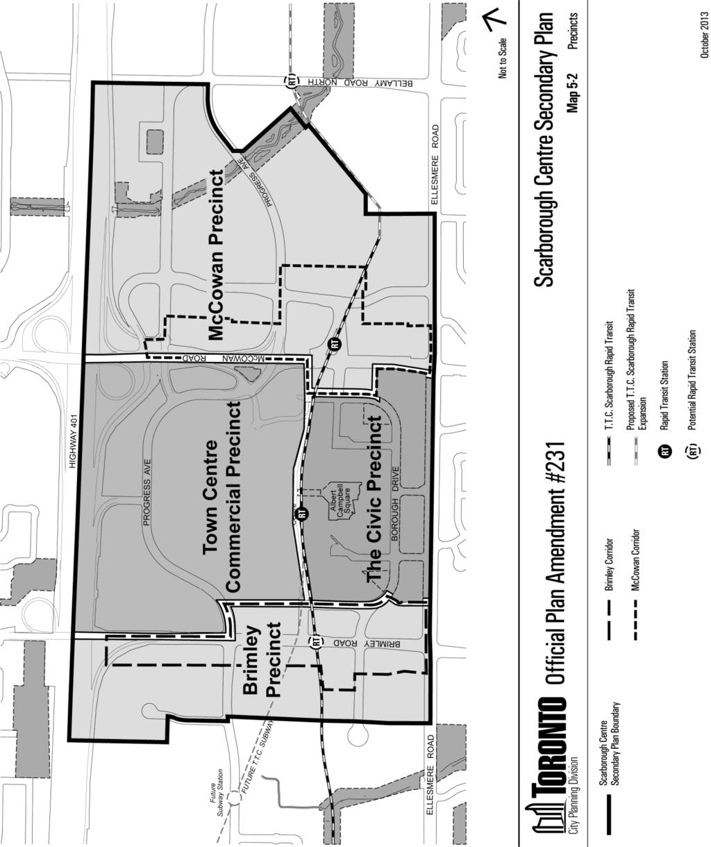
22 Chapter 6, Section 5, Scarborough Centre Secondary Plan, Maps 5-1 to M-5 are amended by incorporating the lands at 675 Progress Avenue into the Scarborough Centre Secondary Plan. Chapter 6, Section 5, Scarborough Centre Secondary Plan, is amended by adding Site and Area Specific Policy No. 8 for the lands known municipally in 2012 as 675 Progress Avenue, as follows: " Progress Avenue a) Development of lands for residential use will incorporate employment uses including a minimum of 13,000 square metres of office floor area which will be provided within Phase 1 of the development. b) A feasibility analysis and impact assessment in accordance with Section of the Province's D-6 Guidelines for Compatibility Between Industrial Facilities and Sensitive Land Uses is to be completed and necessary mitigation measures are to be incorporated into the development design to the satisfaction of the Ministry of the Environment or a delegated authority; and c) New development will be in conformity with the Scarborough Centre Secondary Plan and consistent with the emerging McCowan Precinct Plan policies and guidelines, in particular with respect to the provision of the proposed street and block plan, the provision of new streets and connections to the existing and proposed network, and the provision of community facilities and services." Chapter 6, Section 5, Scarborough Centre Secondary Plan Map 5-1, Urban Structure Plan, is amended by adding the lands at 675 Progress Avenue shown on the map above as Site and Area Specific Policy No
23 23
24 24
25 25
26 26
27 27
28 Chapter 6, Section 7, Downsview Area Secondary Plan, is amended by deleting from the policies and maps of the Secondary Plan all references to, and inclusion of all of the lands in the Secondary Plan area that are located both south of Model Avenue and east of William R. Allen Road and the Highway 401/William R. Allen Road Interchange. Chapter 6, Section 14, Garrison Common North Secondary Plan, is amended by deleting the map and policies for Site and Area Specific Policy No. 1 and replacing it with the following map and text: "1. 28 Bathurst Street, 2 Tecumseth Street, 677, 701 Wellington Street and 53 Strachan Avenue a) The meat processing operations located at 2 Tecumseth Street as of December 16, 2013 are permitted until such time the plant ceases operations. Until such time the plant ceases operations the following will apply: 28
29 i) all development and re-development proponents for sensitive residential uses within 70m of the plant will submit a study prior to the enactment of any zoning by-law amendment that evaluates, to the satisfaction of the City of Toronto in consultation with the Ministry of the Environment, how the proposed sensitive residential use would affect the ability of the plant to carry out normal business activities. The study will also evaluate whether the anticipated users of the proposed residential use will potentially be subject to adverse effects from on-site contamination or from odour, noise and other contaminants that could be discharged from the plant and recommend to the satisfaction of the City any necessary mitigation and/or buffering measures to be undertaken by the proponent; ii) any proposed development for adjacent sites including all lands from 28 Bathurst Street west to Strachan Avenue and north from the rail corridor to King Street West will include a construction management plan as part of the application. The plan will to the satisfaction of the Chief Planner and Executive Director, City Planning Division, evaluate the impact construction vehicles could have on the employment operations at 2 Tecumseth Street and propose mitigation measures if required to be undertaken by the proponent. b) Residential uses along the Bathurst Street frontage of 28 Bathurst Street may be permitted subject to the following: i) the lands have been environmentally remediated to requirements as established by the Ministry of the Environment; ii) iii) iv) the proposed development adheres to the City's Mid-rise Guidelines; the proposed development is appropriately buffered to the satisfaction of the appropriate railway authorities from the rail corridor to the south; and the proposed development is consistent with the results of the Bathurst-Strachan-Wellington area study. c) Until such time as the meat processing facility located at 2 Tecumseth Street ceases operations, no sensitive uses, including residential uses will be permitted on the portion of the lands at 28 Bathurst Street that extends 70m from Tecumseth Street. Non-sensitive uses such as offices, studios, parks, and parking will be permitted in the interim within the 70 metre buffer zone. d) Any proposed development for 28 Bathurst Street, will include a phasing plan to be submitted that among other matters as may be identified addresses to the 29
30 satisfaction of the Chief Planner and Executive Director, City Planning Division, the following: i) if required, strategies to accommodate and if necessary relocate the parking for the employees of 2 Tecumseth Street; ii) impacts proposed construction may have on the adjoining daycare facility and if required any proposed mitigation measures to be undertaken by the proponent; iii) the provision of 1 FSI (net required building setbacks) of employment space on the lands; and iv) timing and phasing of required environmental remediation. e) The area will be subject to a study, which is intended to set out a framework for the potential redevelopment of the area while taking into consideration the need to maintain employment in the area, the need to buffer potentially sensitive uses from impactful ongoing employment operations in the area (i.e.: City works yard), the establishment of effective connections and transition to the existing neighbourhood and the provision of parks and community services. Until this study is completed and the findings implemented, redevelopment that includes residential uses is not permitted on the lands at 2 Tecumseth Street. Amendments to this policy and/or Secondary Plan may be considered as required in order to incorporate and/or implement the conclusions, findings and/or recommendations of the study. In addition to the matters identified in Section of the Official Plan, the study will: i) consider the potential redevelopment of the lands at 2 Tecumseth Street once current meat processing operations have ceased; ii) iii) iv) identify and locate an appropriate land use buffer to be designated General Employment Areas in order to protect and buffer potential sensitive uses on lands east of the City Works and Emergency Services yard located at 677 and 701 Wellington Street West. Employment uses within this buffer zone will be limited to residentially sensitive employment uses such as offices and studios; identify and locate appropriate buffering to the rail corridor on the southern boundary of the study area; explore the potential to exchange and/or purchase/sale of portions of land between owners to achieve the above buffering and create a more efficient ownership pattern for City operations at the Wellington Street West yard; v) address heritage considerations for the Wellington Street incinerator and the potential for adaptive re-use and preservation of the existing structure; 30
31 vi) vii) viii) ix) identify appropriate buffering and transition to the low scale existing residential uses in the area; address measures to effectively link the study area with roads, pathways and/or corridors; identify the appropriate location of new parks, open space and pedestrian links and treatment to existing parks in the area; assess potential view impacts on Fort York due to potential development in the area; x) identify strategies to visually enhance the Front/Bathurst Street terminus; and xi) address the provision, location and/or relocation of community services and facilities in the study area such as daycares, libraries, community/recreation centres and public educational facilities." Chapter 6, Section 14, Garrison Common North Secondary Plan, is amended by deleting the map for Site and Area Specific Policy No. 2 and replacing it with the following map in order to remove 28 Bathurst Street from the map and policies for Site and Area Specific Policy 2. 31
32 Chapter 6, Section 14, Garrison Common North Secondary Plan, is amended by deleting the map and policies for Site and Area Specific Policy No. 3 and replacing it with the following map and text: 32
33 "3. Area 3 Certain lands located in the Blocks Bounded by King Street West, Dufferin Street, Lakeshore Rail Corridor and Hanna Avenue a) A healthy and vibrant employment precinct will be maintained and enhanced for this area of Liberty Village that is fully integrated and connected to the surrounding vicinity and encompasses a broad variety of non-residential land uses. Once the home to some of Canada's largest industrial manufacturers, this area of Liberty Village has reinvented itself as an important centre for the City's creative economy. Instead of factories, primary uses now include offices, studios, research and development facilities, utilities, post-secondary trade schools, and media facilities. Although all 'Employment Industrial' uses as defined under the City's new zoning by-law ( ) are also permitted as primary uses, Area 3 is no longer an appropriate location for 'Employment Heavy Industrial' zone uses. Secondary uses include small scale service uses such as banks, hotels, parks, workplace ancillary daycares, small scale retail and restaurant uses along with 33
34 recreational uses to support the viability of the site's primary office use and provide amenities for the Area's current and future employees. b) In addition to the criteria of the Core Employment Areas designation, small scale restaurants that are ancillary to and support the Area's primary employment uses are permitted provided they are located within the ground floor level of buildings that currently contain or are intended to accommodate primary employment uses. c) Small scale retail uses are permitted throughout Area 3 subject to the criteria of the Core Employment Areas designation. Larger retail uses up to a maximum gross retail floor space of 6,000 square metres may locate in the Area provided: i) the retail use is not stand alone and is proposed to be incorporated into the ground floor of a multi-storey building that that currently contain or are intended to accommodate office uses; ii) iii) the proposed retail use fronts onto and has direct access to either King Street West, Dufferin Street, Liberty Street, Atlantic Avenue or Hanna Avenue; and all other relevant Official Plan policies and conditions for retail uses are met. d) Maintaining and enhancing Area 3 as a vibrant office employment area is a key policy objective of the City and Official Plan. In addition to all relevant policies and objectives of the Official Plan's policies for Employment Areas and the City of Toronto's Economic Development Strategy, the City will continue to work in partnership with local area landowners, businesses, associations and interested parties both public and private to ensure this area remains an attractive location for economic activity and business investment. With the exception of changing the underlying employment land use designation, amendments to this policy and Secondary Plan may be considered as required in order to incorporate and/or implement the conclusions, findings and/or recommendations of current or future studies particularly as they relate to the following: i) built form improvements; ii) iii) iv) enhanced transportation links including the addition of new roads, transit and rapid transit infrastructure, pedestrian pathways and connections; identifying locations for new open spaces, parks and plazas; streetscape improvements; v) urban design guidelines; 34
35 vi) vii) infrastructure improvements; and improved and/or additional community services and facilities." Chapter 6, Section 14, Garrison Common North Secondary Plan, is amended by deleting the map and policies for Site and Area Specific Policy No. 4 and replacing it with the following map and text: "4. Portion of 171 East Liberty Street a) The lands located at 171 East Liberty Street as shown on the map are within an area of Liberty Village that transitions from the envisioned office and employment centre located west of Hanna Avenue to the medium and higher density residential areas that have been built east of Hanna Avenue to Strachan Avenue. Although, the lands are surrounded on the north and east sides by high density residential and retail uses, it is the objective of this policy to ensure the lands retain a significant amount of space for employment uses and provide for needed community facilities. b) In accordance with a) above, any mixed use redevelopment of the subject lands will include: i. A minimum of 2,000 square metres of retail space; ii. iii. A minimum of 12,000 square metres of office space; and Space for community facilities and services. 35
36 Chapter 6, Section 14, Garrison Common North Secondary Plan, is amended by adding Site and Area Specific Policy No. 8 for the lands located at 11 and 25 Ordnance Street and Strachan Avenue, as follows: "8. Area 8 11 and 25 Ordnance Street and Strachan Avenue a) A minimum of 1 FSI of employment space that is compatible with residential uses will be incorporated into any development that includes residential units; and b) Space for community infrastructure is to be provided." Chapter 6, Section 14, Garrison Common Secondary Plan Map 14-1, Site and Area Specific Policies, is deleted and replaced with thefollowing map. 36
37 37
38 Amendments to Chapter 7, Site and Area Specific Policies 15. Chapter 7, Site and Areas Specific Policies is amended as follows: Chapter 7, Site and Area Specific Policies, is amended by replacing Site and Area Specific Policy No. 15 with the following: "15. East of Park Lawn Road and North of Lake Shore Boulevard West a) Development proposals will be considered through a comprehensive plan that responds to the Employment Areas policies of the Plan and: i) locates a broad range of employment uses to the site, including possible educational and/or institutional uses through public-private partnerships; ii) iii) iv) acknowledges the importance of the Ontario Food Terminal by not creating any adverse impacts upon the Ontario Food Terminal; facilitates the creation of a cluster of employment uses with a broad range of amenities for workers and nearby residents; contributes to the multi-modal transportation connectivity, including GO Transit, TTC, bike lanes and trails, sidewalks and streets; v) designs a compatible built form that transitions from nearby uses and provides flexible employment spaces at varying scales and tenures, which could include the potential reuse of the existing structure/building or parts thereof; vi) vii) maximizes the site's location, visibility, accessibility, and size to accommodate employment intensification on the site; and accommodates and integrates infrastructure requirements for the site and surrounding area." 38
39 Chapter 7, Site and Area Specific Policies, is amended by replacing Site and Area Specific Policy No. 154 with the following: "154. Lands Located South of Eileen Avenue, East of Gailmort Place Lands Located East of Keele Street, Between Lavender Road and Hillary Avenue Lands Located on the West Side of Bronoco Avenue Between Alessia Circle and North of Summit Avenue Certain Lands Located on the West Side of Gilbert Avenue Certain Lands Along the North Side of Hopewell Avenue North Side of Geary Avenue Between Dovercourt Road and Ossington Avenue 53 Colgate Avenue Lands Generally Adjacent to the South Side of the Railway Tracks Between Brock Avenue and Queen Street West 7-77 Florence Street and Dufferin Street 138, 150 and 152 St. Helens Avenue; 9 Dora Avenue and 6, 7, 8 and 9 Dublin Street Lands Within the Miller Street and Lindner Street Area Both Sides of Mulock Street South of Lloyd Avenue, and East Side of Keele Street between Junction Road and North of Hirons Street Lands Located East of Sorauren Avenue, South of Dundas Street West and 30 Morrow Avenue a) Employment, place of worship and residential uses are permitted within single use or mixed use buildings provided that: i) if the property is designated Employment Areas, any building containing a place of worship and/or residential units will provide for a satisfactory environment compatible with any employment uses in the building and adjacent area; ii) iii) if the property is designated Neighbourhoods, the employment uses are restricted to those compatible with residential uses in terms of emissions, odour, noise and generation of traffic; the height, density and massing of new development respects and reinforces the existing and planned physical character of the adjacent area; and iv) residential and place of worship uses are located a minimum of 30 metres from the nearest rail corridor. b) Despite a) above, hotels are not permitted. c) Despite a) above, retail, service and restaurant uses are not permitted, except at Brock Street and Queen Street West where the uses are permitted when they are small in scale." 39
40 40
41 41

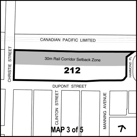
42 Chapter 7, Site and Area Specific Policies, is amended by deleting Site and Area Specific Policy No Chapter 7, Site and Area Specific Policies, is amended by deleting Site and Area Specific Policy No. 212 and replacing it with the following for the lands shown on the attached map Dupont Street Corridor 42
43 43
44 1) A Secondary Plan or Site and Area Specific Policy (SASP) to guide the revitalization of Dupont Street between Kendal and Ossington Avenues will be enacted for lands that are located 30 metres south from the Toronto North Subdivision rail corridor and are designated Regeneration Areas on Map 17 of the Official Plan. In addition to the matters identified in Policy 2 of Section 4.7 of the Official Plan, the area study leading to the Secondary Plan or SASP will: a) Apply the mid-rise guidelines for development and provide appropriate scale transition to the low scale residential uses along the southern frontage of Dupont Street and to the lands designated General Employment Areas to the rear; b) Explore the use of a Development Permit system within the lands along the northern frontage of Dupont Street; c) Assess and where appropriate establish maximum limits on the size of retail developments and floor plates within the study area; d) Identify transportation and transit options and policies for the Dupont corridor; e) Assess the feasibility of locations for mixed use development. Any mixed use development that proposes to introduce sensitive and/or non-employment uses shall only occur on sites that can accommodate the appropriate buffering and/or rail safety measures as may be required along with any required set-backs from Dupont Street in order to accommodate streetscaping initiatives; f) Ensure there is a net gain in employment floor space for any developments that include residential units; 44
45 g) Identify and enact any required polices and/or measures to ensure appropriate access from Dupont Street to the lands designated General Employment Areas is maintained; h) Identify appropriate rail corridor buffering measures to the satisfaction of the relevant railway authorities; i) Identify potential locations for additional pathways and pedestrian links between the low scale residential uses to the south and the employment and rail corridor to the north within the study area; j) Identify the appropriate location for new parks, open space and green corridors including exploring the opportunity of locating a greenway recreational path along the southern edge of the abutting rail corridor ; k) Identify strategies to enhance the public realm and streetscaping on both the north and south side of Dupont Street within the Secondary Plan or SASP area; l) Explore and identify measures to improve the overall business environment of the area; and m) Bring forward an enacting zoning by-law or development permit system for the study area. 2) Until the study is completed and the Secondary Plan or SASP is in force, development that includes residential and/or other sensitive uses is not permitted. 3) Uses provided for in General Employment Areas that are compatible with nearby residential uses are permitted on all sites and lands along the northern side of Dupont Street between Kendal and Ossington Avenues. Additional uses are permitted in the General Employment Areas designated lands within the 30 m rail corridor setback zone as follows: a) Parking that supports the employment uses of the area either at grade or in a structure; b) Roads and utilities; and c) Rail safety measures (i.e.: berms, crash walls etc.). 4) Until the Secondary Plan or SASP is in force, any proposals for employment use development will: a) Provide appropriate buffering and rail safety measures as required to the satisfaction of the appropriate rail authorities and the City; 45

46 b) Be sufficiently set-back from Dupont Street to accommodate streetscaping improvements and initiatives; and c) Contribute to streetscaping improvements along both the north and south sides of Dupont Street. Chapter 7, Site and Area Specific Policies, is amended by adding Site and Area Specific Policy No. 247 for certain lands within the blocks bounded by Queen Street East, Boston Avenue, Logan Street and the CN Railway Tracks as follows: "247. Certain Lands Within the Blocks Bounded by Queen Street East, Boston Avenue, Logan Street and the CN Railway Tracks a) Residential and live/work uses are permitted when located within mixed use buildings that include Core Employment Area uses, provided that: i) any building containing residential and/or live/work units will provide for a satisfactory living environment compatible with any employment uses in the building and adjacent area; ii) iii) iv) new Core Employment Area uses are restricted to those compatible with residential uses in terms of emissions, odour, noise and generation of traffic; the height, density and massing of new development respects and reinforces the existing and planned physical character of the adjacent area; residential, live/work and place of worship uses are located a minimum of 30 metres from the nearest rail corridor; and v) non-residential gross floor area existing on December 16, 2013 or developed subsequently is replaced with any new development. b) Despite a) above, retail, service and restaurant uses to serve residents and/or businesses are permitted when they are small in scale and located on Carlaw Avenue and/or Dundas Street East. 46
47 c) A neighbourhood improvement plan will set out a broader vision for neighbourhood amenities and public realm improvements." Chapter 7, Site and Area Specific Policies, is amended by adding the following paragraph at the end of Site and Area Specific Policy No. 310 for the lands known municipally in 2012 as 350 Progress Avenue (lands at the northwest corner of Progress Avenue and Schick Court): "The following additional uses accessory to office uses are permitted: financial institutions, personal service shops, recreational uses, restaurants and retail stores, with the total gross floor area of all accessory uses not to exceed 10% of the total built gross floor area of the City Centre Office (CCO) Uses." Chapter 7, Site and Area Specific Policies, is amended by adding Site and Area Specific Policy No. 313 for the lands on the west side of Caledonia Road, between St. Clair Avenue West and Lambert Avenue, as follows: "313. Lands Located on the West Side of Caledonia Road, Between St. Clair Avenue West and Lambert Avenue a) Core Employment Area uses are restricted to those compatible with residential uses in terms of emissions, odour, noise and generation of traffic. b) Once the concrete batching use ceases to operate on the lands known municipally as 32 Caledonia Road and 1536 St. Clair Avenue West, residential uses are permitted on lands shown as Site and Area Specific Policy No. 313 within single use or mixed use buildings, provided that: i. any building containing residential units will provide for a satisfactory living environment compatible with any employment uses in the building and adjacent area; ii. the height, density and massing of new development respects and reinforces the existing and planned physical character of the adjacent area, including lands to the north, east and south that are designated as Neighbourhoods and Mixed Use Areas; 47
48 iii. iv. residential uses are located at a satisfactory distance from the rail corridor; and non-residential gross floor area existing on December 16, 2013 or developed subsequently is replaced with any new development, preferably adjacent to the rail corridor as a land use buffer. c) Cultural and recreational facilities are permitted. d) Retail, service and restaurant uses to serve residents and/or businesses are permitted when they are small in scale and located on Caledonia Road."' Chapter 7, Site and Area Specific Policies, is amended by adding Site and Area Specific Policy No. 386 for the lands bounded by Sheppard Avenue East, Victoria Park Avenue, Highway 401, the Highway 401/Highway 404 Interchange and Highway 404, as follows: "386. Lands bounded by Sheppard Avenue East, Victoria Park Avenue, Highways 401 and
49 a) An implementation plan will be established as Official Plan policy to address within Areas "A", "B" and "C" matters such as: i) an incentive program for Council adoption to encourage office development; ii) the provision of amenities throughout the area to create an attractive environment for existing and new offices; iii) development densities; and iv) the creation of new streets and blocks. Area "A" b) Development in Area "A" that includes residential units is required to also increase the non-residential gross floor area in Area "A". Area "B" c) Prior to the approval of residential development on Mixed Use Area land in Area "B", a Noise Impact Study is required to determine appropriate design and separation distances of residential units and sensitive non-residential uses from the Direct Fuel Cell-Energy Recovery Generation power plant at 500 Consumers Road. d) Development on Mixed Use Area land in Area "B" that includes residential units is required to also increase the non-residential gross floor area in Area "B", on land designated as Mixed Use Areas and/or on land designated as General Employment Areas. e) Employment Area uses in Area "B" are limited to those that are compatible with adjacent existing and planned residential uses in Area "A" and on the Mixed Use Areas land in Area "B". Area "C" f) Employment Area uses in Area "C" are limited to those that are compatible with adjacent existing and planned residential uses in Areas "A" and "B". g) Major retail development with 6,000 square metres or more of retail gross floor area are not permitted in Area "C". h) Restaurants, workplace daycares, recreation and entertainment facilities, and small and medium scale retail stores and services are only permitted in Area "C" when these uses are located on lower level floors of multi-storey buildings that include Core Employment Area uses, particularly office uses." 49

50 Chapter 7, Site and Area Specific Policies, is amended by adding Site and Area Specific Policy No. 387 for the lands bounded by Wilson Heights Boulevard, Wilson Avenue, Champlain Boulevard, Highway 401, the Highway 401/William R. Allen Road interchange and William R. Allen Road, as follows: "387. The Tippett Road Area A framework for new development on the lands will be set out in either a Secondary Plan or a Site and Area Specific Policy to address the matters that are identified in Section of the Plan and also matters such as the following: a) Streets, pedestrian connections, blocks, densities and building heights; b) A requirement that 50 per cent or greater of the gross floor area on lands in Parcel "A" be used for non-residential purposes; c) A requirement that development in Parcel "B" that includes residential units also increase the non-residential gross floor area in Parcel "B"; and 50
51 d) A land use buffer to appropriately separate residential and sensitive non-residential uses from Highway 401, the Highway 401/William R. Allen Road expressway interchange and the William R. Allen Road expressway, and the design of residential units and buildings containing sensitive non-residential uses to mitigate noise and vibration from the highways." Chapter 7, Site and Area Specific Policies, is amended by adding Site and Area Specific Policy No. 388 for the lands south of Wilson Avenue, east of Dufferin Street and north of the Highway 401/Dufferin Street Interchange, as follows: "388. Lands Southeast of Wilson Avenue and Dufferin Street Instead of a Secondary Plan, a Site and Area Specific Policy is required to set out a framework for new development on the lands to address those matters identified in Section of the Plan and also matters such as the following: a) Land use buffers to appropriately separate residential and sensitive nonresidential uses from the abutting Employment Area lands directly to the east and from the Dufferin Street/Highway 401 interchange and Highway 401 to the south. b) The design of any residential uses and buildings containing sensitive non-residential uses to mitigate noise and vibration from the Employment Area lands directly to the east and from the Dufferin Street/Highway 401 interchange and Highway 401 to the south. c) A street and block plan that includes a public street to connect Billy Bishop Way to Wilson Avenue and other appropriate connections; and d) A requirement that development including residential units also increase the non-residential gross floor area." Chapter 7, Site and Area Specific Policies, is amended by adding Site and Area Specific Policy No. 389 for the lands known municipally in November 2013 as Murray Road, as follows: 51
52 " Murray Road Instead of a Secondary Plan, a Site and Area Specific Policy is required to set out a framework for new development on the lands to address the matters that are identified in Section of the Plan and also matters such as the following: a) A land use buffer of Core Employment Area uses on the north portion of the lands that is compatible with and sensitive to adjacent existing and planned residential and sensitive non-residential uses; b) A low scale residential built form on lands south of the land use buffer described above, that is compatible with and sensitive to the existing low scale residential neighbourhood located east of the lands; c) A requirement that residential and sensitive non-residential uses only be permitted on the lands south of the land use buffer described above, once the concrete batching use ceases to operate on the lands; d) Opportunities for commercial uses at the Wilson Avenue frontage; e) A street and block plan that includes pedestrian and cycling connections; and f) A setback of any residential and sensitive non-residential use from the rail corridor west of the lands.' 52
53 Chapter 7, Site and Area Specific Policies, is amended by adding Site and Area Specific Policy No. 390 for certain lands northwest of Dufferin Street and Eglinton Avenue West, as follows: "390. Castlefield Caledonia Design and Décor District a) On lands designated General Employment Areas, retail uses are limited to design and décor retail establishments, including but not limited to the sale of home furnishings and appliances, home renovation, garden and landscaping supplies. b) Small scale retail outlets that are ancillary to and on the same lot as a principal manufacturing or warehouse/distribution establishment are also permitted." 53
54 Chapter 7, Site and Area Specific Policies, is amended by adding Site and Area Specific Policy No. 391 for certain lands southwest of Castlefield Avenue and Dufferin Street, as follows: " , 1141, 1151, 1171, 1173, 1185 and 1203 Roselawn Avenue, 103 and 110 Fairbank Avenue and certain lands east of 76 Miranda Avenue Employment uses that are compatible with nearby residential uses are permitted. Motor vehicle repair shops, motor vehicle collision repair shops, motor vehicle sales establishments and car washing establishments are not permitted." 54
55 Chapter 7, Site and Area Specific Policies, is amended by adding Site and Area Specific Policy No. 392 for lands known municipally in 2012 as 1002 and 1020 Lawrence Avenue West and certain lands on Cartwright Avenue east of Caledonia Road, as follows: " and 1020 Lawrence Avenue West, Cartwright Avenue (odd numbers) and Cartwright Avenue (even numbers) Small and medium scale retail stores and services are permitted." 55
56 Chapter 7, Site and Area Specific Policies, is amended by adding Site and Area Specific Policy No. 393 for lands known municipally in 2012 as Vanderhoof Avenue and 10 Brentcliffe Road, as follows: " Vanderhoof Avenue and 10 Brentcliffe Road Retail and service uses are permitted, except for major retail developments with 6,000 square metres or more of retail gross floor area which are prohibited." 56
 New major retail developments with 6,000 square metres or more of retail floor area are not permitted.")
57 Chapter 7, Site and Area Specific Policies, is amended by adding Site and Area Specific Policy No. 394 for business park lands along the Don Valley Parkway Corridor, as follows: "394. Business Parks along the Don Valley Parkway Corridor a) New major retail developments with 6,000 square metres or more of retail floor area are not permitted. b) Restaurants, workplace daycares, recreation and entertainment facilities, and small and medium scale retail stores and services are only permitted when these uses are located on lower level floors of multi-storey buildings that include Core Employment Area uses, particularly office uses. 57
58 " Chapter 7, Site and Area Specific Policies, is amended by adding Site and Area Specific Policy No. 395 for the lands bounded by Steeles Avenue East, Go Train Corridor, Redlea Avenue Extension and the north boundary of properties on Passmore Avenue, as follows: "395. Lands bounded by Steeles Avenue East, Go Train Corridor, Redlea Avenue Extension and the north boundary of properties on Passmore Avenue 58
59 a) Development of the lands will proceed in accordance with a framework to be established through a study of the area that addresses the matters identified in Section of the Official Plan and also the following matters: i. a land use buffer to appropriately separate residential and sensitive non-residential uses from nearby Employment Areas; ii. iii. iv. appropriate separation to the Go Train corridor on the east boundary of the study area; the design of any sensitive uses and buildings containing residential and other sensitive uses to mitigate noise, vibration and other adverse effects from the Employment Areas lands and the Go Train corridor; a street and block plan that includes the Redlea Avenue Extension and other appropriate connections; v. a requirement that development of residential units also provide the gross floor area of office employment uses; and vi. a requirement that Redlea Avenue is extended to Passmore Avenue prior to new development within the lands subject to Site and Area Specific Policy No b) The above noted study is deemed to satisfy the requirement for a secondary plan pursuant to Section of the Official Plan." 59
60 Chapter 7, Site and Area Specific Policies, is amended by adding Site and Area Specific Policy No. 396 for the lands bounded by Eglinton Avenue East, Brentcliffe Road, Vanderhoof Avenue and Laird Drive, as follows "396. Lands bounded by Eglinton Avenue East, Brentcliffe Road, Vanderhoof Avenue and Laird Drive a) General Employment Area uses in Area "A" are limited to those that are compatible with residential and sensitive non-residential uses permitted in the adjacent Mixed Use Areas and Neighbourhoods. b) Major retail developments with 6,000 square metres of retail floor area are not permitted in Area "A". c) Development on the Mixed Use Area land that includes residential units is required to also increase the non-residential gross floor area on the lands shown as Site and Area Specific Policy No d) Given the presence of industries to the south and southeast of the lands, a study of noise, dust, odour and other industrial related impacts is required prior to the approval of residential development and/or sensitive nonresidential uses on the Mixed Use Area lands so that appropriate design standards and building heights can be determined for buildings containing residential and/or sensitive non-residential uses." 60
61 Chapter 7, Site and Area Specific Policies, is amended by adding Site and Area Specific Policy No. 410 for the lands that are known municipally in 2012 as 1121 Leslie Street, as follows: " Leslie Street Employment Area uses on the lands are limited to those that are compatible with residential and sensitive non-residential uses that are permitted on the lands located to the south." Chapter 7, Site and Area Specific Policies, is amended by adding Site and Area Specific Policy No. 412 for the lands known municipally in 2012 as 2781 Markham Road, as follows: " Markham Road a) Place of worship and ancillary community centre uses are permitted." 61
62 Chapter 7, Site and Area Policies, is amended by adding Site and Area Specific Policy No. 413 for the lands known municipally in 2012 as 35 Auto Mall Drive, 958 Milner Avenue and adjacent lands, as follows: " Auto Mall Drive, 958 Milner Avenue and adjacent lands a) Prior to the approval of a zoning by-law permitting the development of the lands the owner will make arrangements with respect to the closure, purchase and re-alignment of a section of Auto Mall Drive, to the satisfaction of the City of Toronto in consultation with Metrolinx. b) Development will: i. provide a strong building relationship to street edges, in particular to Sheppard Avenue East, to enhance visual identity, accessibility to public transit, and to create an attractive and comfortable streetscape; ii. iii. achieve efficient use of the land by providing buildings fronting Sheppard Avenue East to be a minimum of 2 storeys and parking layout minimizing the use of available land and screened from adjacent streets; and address floodplain management issues and incorporate any necessary mitigation measures to the satisfaction of the Toronto and Region Conservation Authority. c) Major retail development with retail gross floor area of 6,000 square metres or more is permitted." 62
63 Chapter 7, Site and Area Policies, is amended by adding Site and Area Specific Policy No. 414 for the lands known municipally in 2012 as 21 Broadview Avenue, as follows: " Broadview Avenue Before any zoning by-law permitting the development of residential uses on the subject site is enacted the owner shall: a) Provide a minimum, net of required building setbacks, of 1 FSI of employment space on the ground floor; b) Undertake an environmental study in addition to a feasibility analysis and impact assessment as required under Section of the province's D-6 Guidelines for Compatibility Between Industrial Facilities and Sensitive Land Uses to the satisfaction of the City in consultation with the Ministry of Environment; and c) Be subject to all conditions and requirements as set by the City, the Toronto and Region Conservation Authorityand the province regarding the site's location within the Lower Don Special Policy Area." Chapter 7, Site and Area Policies, is amended by adding Site and Area Specific Policy No. 415 for the lands known municipally in 2012 as 459 Eastern Avenue, as follows: " Eastern Avenue a) Only those employment uses such as offices, parks, small scale restaurants, retail and service uses that are compatible to the nearby low scale residential dwellings fronting onto Logan Avenue are permitted. 63
64 Chapter 7, Site and Area Policies, is amended by adding Site and Area Specific Policy No. 416 for the lands known municipally in 2012 as 462 Eastern Avenue, as follows: " Eastern Avenue Before any zoning by-law permitting the development of residential uses on the subject site is enacted the owner shall: a) Provide employment space(s) along the Eastern Avenue frontage between Booth and Logan Avenues; b) Ensure the proposed development provides transition in scale to the low scale Neighbourhoods to the north, east and west in accordance with the policies of the Plan; c) Undertake an environmental study in addition to a feasibility analysis and impact assessment as required under Section of the province's D-6 Guidelines for Compatibility Between Industrial Facilities and Sensitive Land Uses to the satisfaction of the City in consultation with the Ministry of Environment; and d) Be subject to all conditions and requirements as set by the City, the Toronto and Region Conservation Authorityand the province regarding the site's location within the Lower Don Special Policy Area." Chapter 7, Site and Area Policies, is amended by adding Site and Area Specific Policy No. 417 for the lands known municipally in 2012 as 54 Logan Avenue, as follows: " Logan Avenue One residential unit ancillary to the employment uses on the site is permitted to provide temporary accommodation for visiting workers." 64
65 Chapter 7, Site and Area Policies, is amended by adding Site and Area Specific Policy No. 418 for the lands known municipally in 2012 as 536 Eastern Avenue, as follows: " Eastern Avenue Employment space that is compatible with on-site residential uses is required on the ground floor of any redevelopment proposed for the site." Chapter 7, Site and Area Policies, is amended by adding Site and Area Specific Policy No. 419 for the lands known municipally in 2012 as 362 Wallace Avenue, as follows: " Wallace Avenue Residential uses on the site are permitted if the following conditions are met: a) A new public road running north/south, generally from the southern terminus of Edwin Avenue, through the site to Wallace Avenue is provided; b) Macaulay Avenue is extended to meet the new public road described in (a) above; c) A minimum of 3,800 square metres of non-residential gross floor area is constructed on the site prior to or at the same time as any residential gross floor area; d) Only residentially-compatible employment uses are permitted on the lands designated General Employment Areas; 65
66 e) Any required alterations to the Wallace Avenue pedestrian bridge must respect the heritage designation of the bridge and the bridge must remain open during the alterations; f) A 3 metre wide publicly accessible pedestrian connection through the site to allow access from the terminus of Macaulay Avenue to the West Toronto Railpath will be provided; g) Site design must not have any negative impact on the West Toronto Railpath, and the elevation of any building constructed adjacent to the West Toronto Railpath will provide overlook to the path; and h) The western terminus of Wallace Avenue will be designed as a meeting/gathering place, and any buildings constructed at the south end of the site will face onto this space and provide animation." Chapter 7, Site and Area Policies, is amended by adding Site and Area Specific Policy No. 420 for the lands known municipally in 2012 as 50 Edwin Avenue, as follows: " Edwin Avenue For the portion of the site designated General Employment Areas only residentially compatible employment uses such as offices, studios, small scale restaurants, retail and service uses as well as parks are permitted. Parking ancillary to and supportive of redevelopment of the portion designated Neighbourhoods is also permitted within the General Employment Areas portion." 66
67 Chapter 7, Site and Area Policies, is amended by adding Site and Area Specific Policy No. 421 for the lands known municipally in 2012 as 299 Campbell Avenue, as follows: " Campbell Avenue a) Only those employment uses that are compatible to the nearby low scale residential dwellings fronting onto Campbell Avenue are permitted; and b) Arts training facilities, studios and entertainment and recreation facilities are permitted." Chapter 7, Site and Area Policies, is amended by adding Site and Area Specific Policy No. 422 for the lands known municipally in 2012 as 300 Campbell Avenue, as follows: " Campbell Avenue a) Only those employment uses that are compatible to the nearby low scale residential dwellings fronting onto Campbell Avenue are permitted; and b) Arts training facilities, studios and entertainment and recreation facilities are permitted." 67
68 Chapter 7, Site and Area Policies, is amended by adding Site and Area Specific Policy No. 423 for the lands known municipally in 2012 as 1453 Dupont Street, as follows: " Dupont Street a) Only those employment uses that are compatible to the nearby low scale residential dwellings south of the site are permitted; and b) Parking to support the employment uses at 299 Campbell Avenue is permitted." Chapter 7, Site and Area Policies, is amended by adding Site and Area Specific Policy No. 424 for the lands known municipally in 2012 as 11 Peel Avenue, as follows: " Peel Avenue Residential uses are only permitted provided the following conditions of redevelopment are met: a. A minimum density of one times the area of the lot of non-residential uses must be provided as part of any redevelopment of the lot b. A minimum density of 0.35 times the area of the lot of nonresidential, non-retail uses must be provided as part of any redevelopment of the lot. c. A commercial parking garage does not count towards the nonresidential or non-retail uses as described in (a) and (b) above. d. The maximum gross floor area of any one retail store on the site (including back of house 68
69 activities) is 2,300 square metres. e. Publicly accessible pedestrian connections through the site to allow access from Gladstone Avenue to Dufferin Street must be provided. f. No new shadowing on properties designated as Neighbourhoods is permitted on the spring and fall equinoxes beyond the as-of-right zoning as of October 1, g. The site must provide direct pedestrian access to Queen Street West." Chapter 7, Site and Area Policies, is amended by adding Site and Area Specific Policy No. 425 for the lands known municipally in 2012 as 150 Symes Road, as follows: " Symes Road In addition to all the uses provided for in the Core Employment Areas designation the following uses shall be permitted: a) Service commercial, and indoor recreational and entertainment uses are permitted through the enactment of a zoning by-law; b) Institutional uses, including postsecondary trade schools that are ancillary to and/or supportive of the site's employment uses are also permitted through the enactment of a zoning by-law; c) The above noted uses are potentially sensitive uses. Prior to the enactment of any zoning by-law amendment a study will be submitted by the applicant that evaluates, to the satisfaction of the City in consultation with the Ministry of the Environment, how the potentially sensitive use would affect the ability of existing and planned industrial, warehouse, utility, transportation and city yard uses along Glen Scarlett Road to carry out normal business activities. The study also evaluate whether the anticipated users will potentially be subject to adverse effects from on-site contamination or from odour, noise and other contaminants that are discharged from existing and planned industrial, warehouse, utility, transportation and city yard uses along Glen Scarlett Road. 69
70 d) The applicant shall submit studies demonstrating to the City's satisfaction that there will be no, or minimal impacts related to the redevelopment of the site on the residential area located to the south. The study will assess, among other matters as identified during the application process, impacts associated with traffic, parking and noise and identify any mitigation measures to be undertaken by the applicant." Chapter 7, Site and Area Policies, is amended by adding Site and Area Specific Policy No. 426 for the lands known municipally in 2012 as 21 Don Roadway, as follows: " Don Roadway a) A comprehensively planned employment precinct that is fully integrated and connected to the surrounding area and that encompasses a broad variety of non-residential land uses should be created on the subject lands. A mixture of non-residential uses are permitted, with a majority of the development consisting of offices, post-secondary colleges / universities / trade schools, hotels, studios, and research facilities. Uses which will support the viability of the precinct's employment uses noted above, such as recreation, entertainment, retail, and service commercial are permitted. These uses will provide amenities for the precinct's current and future employees, and will create a vibrant and animated urban district. b) Proposals which include major retail of 6,000 square metres or more of retail gross floor area will be permitted when such uses are planned to be physically connected and / or functionally integrated with structures and / or open spaces associated with the precinct's employment uses. Proposals for major retail development will be subject to the development criteria set out in subsections a) to e), g) and h) of Policy At grade parking associated with major retail development will only be used as an interim measure and will not be located between the retail uses and the public sidewalk and will be located at the flank or rear of the building. c) A comprehensive plan for a new employment precinct that includes consideration of the relationship and connections to the existing uses at 30 Booth Avenue, 405 and 433 Eastern Avenue as described in a) above will only be implemented by way of an enacting zoning by-law. In addition to the General Employment Areas policies and all other relevant policies of the Official Plan, the following policies will apply: 70
71 i) the comprehensive plan for the redevelopment of the precinct will address land use, built form, land division, interim development conditions, public realm connections and appropriate transition in built form to low-scale residential uses north of Eastern Avenue. The comprehensive plan will identify transportation demands and impacts generated by the development, as well as transportation infrastructure improvements and mitigation measures that are necessary. ii) iii) iv) the City will secure phasing of development to ensure that development of the precinct's employment uses accompanies development of the other permitted uses and that at full build-out of the employment precinct, no more than 20% of the total gross floor area is devoted to retail, major retail, service commercial, recreation and entertainment uses. proposed development for the precinct will include a mix of nonresidential land uses which are consistent with the objectives of the Official Plan's policies for Employment Areas and the City of Toronto's Economic Development Strategy. prior to the enactment of any zoning by-law amendment a study will be submitted by the applicant to the satisfaction of the City of Toronto in consultation with the Ministry of the Environment, that evaluates how potentially sensitive uses such as post secondary colleges, universities, trade schools, hotels, recreation and entertainment uses within 1,000 metres of the existing Enbridge facility located at 405 Eastern Avenue and the City works yard located at 433 Eastern Avenue, would affect the ability of those facilities to carry out normal business activities. The study will also evaluate whether the anticipated users will potentially be subject to adverse effects from onsite contamination or from odour, noise and other contaminants that could be discharged from the Enbridge facility and City works yard and recommend to the satisfaction of the City any necessary mitigation and/or buffering measures to be undertaken by the proponent. v) the City, the TRCA, and the province will be satisfied that adequate flood mitigation and reduction measures can be provided. The proposal will also be compatible, and sensitively integrated with the planned naturalization of the Don River. d) The City will review this policy within five years of it coming into effect." 71
72 Chapter 7, Site and Area Policies, is amended by adding Site and Area Specific Policy No. 427 for the lands known municipally in 2012 as 629, 633 and 675 Eastern Avenue, as follows: " , 633 and 675 Eastern Avenue a) In addition to all relevant Official Plan policies and uses permitted under the Core Employment Areas land use designation, film and media training facilities that are intended to strengthen and reinforce the site's primary employment uses are also permitted. Secondary uses including recreation, entertainment, retail and service commercial are also permitted up to a maximum of 20% of the gross floor area through the enactment of a zoning by-law provided such uses are ancillary to and/or support the viability of the site's primary employment uses as well as provide amenities for the site's current and future employees. b) Stand alone retail uses of 6,000 square metres or greater are not permitted on the subject lands. c) The above described secondary uses are permitted only subject to the following: i) the implementing zoning by-law implements a comprehensive plan for the site which provides for a mix of primary employment uses that are consistent with the objectives of the Official Plan's policies for Employment Areas and the City of Toronto's Economic Development Strategy; ii) The implementing by-law will permit stand alone retail uses of less than 6,000 square metres only when such uses are intended to support the viability of the primary employment uses and provide amenities to current and future employees. Permitted retail uses are to be located with frontage onto and provide direct entrances from publicly accessible pedestrian spaces, the sidewalks of public streets, and/or the sidewalks of private driveways designed to City standards for new streets; 72
73 iii) iv) the City will secure phasing of development to ensure that development of the site's primary employment uses precedes or accompanies development of the other permitted secondary uses; recreation and entertainment uses are potentially sensitive uses. Prior to the enactment of any zoning by-law amendment a study will be submitted by the applicant that evaluates, to the satisfaction of the City of Toronto in consultation with the Ministry of the Environment, how the potentially sensitive use would affect the ability of existing, planned and potential industrial, warehouse, utility, transportation and city yard uses within 1,000 metres to carry out normal business activities. The study will also evaluate whether the anticipated users will potentially be subject to adverse effects from on-site contamination or from odour, noise and other contaminants that are discharged from existing, planned or potential industrial, warehouse, utility, transportation and city yard uses within 1,000 metres of the proposed new sensitive use; and v) the City, the Toronto and Region Conservation Authority and the Province will be satisfied that adequate flood mitigation and reduction measures have been provided." 73
74 Chapter 7, Site and Area Policies, is amended by adding Site and Area Specific Policy No. 429 for the lands known municipally in 2012 as 45 Ernest Avenue, as follows: " Ernest Avenue For the portion of the site designated General Employment Areas only employment uses that are compatible with adjacent residential development such as offices, studios, small scale restaurants, retail and service uses as well as parks are permitted. Parking ancillary to and supportive of redevelopment of the portion designated Neighbourhoods is also permitted within the General Employment Areas portion." Chapter 7, Site and Area Specific Policies, is amended by adding Site and Area Specific Policy No. 430 for the lands known municipally in 2013 as 145 Evans Avenue and Islington Avenue as follows: " Evans Avenue and Islington Avenue Area "A" a) Employment uses will be compatible with nearby sensitive residential uses. b) Social, cultural, institutional and entertainment uses are permitted. c) Major retail development with 6,000 square metres or more of retail gross floor area is not permitted." Area "B" d) Residential buildings heights will provide a transition to the low-rise established Neighbourhoods lands to the north and east." 74
75 Chapter 7, Site and Area Specific Policies, is amended by adding Site and Area Specific Policy No. 431 for the lands known municipally in 2013 as 956 Islington Avenue as follows: " Islington Avenue a) Any sensitive uses on the site will require environmental mitigation measures including, noise, vibration, and odour between the lands and the existing Employment Areas to the west and rear of the site to the Chief Planner and Executive Director, City Planning's satisfaction. b) Any new streets proposed on the site will comply with the City's Development Infrastructure Policy and Standards (DIPS), along with the Public Realm policies (3.1.11) of the Plan. c) Major retail developments with 6,000 square metres or more of retail gross floor area are not permitted." Chapter 7, Site and Area Specific Policies, is amended by adding Site and Area Specific Policy No. 432 for the lands known municipally in 2013 as The Queensway, as follows: " The Queensway a) Entertainment and recreation uses are permitted. b) Employment uses will be compatible with nearby residential uses." 75
76 Chapter 7, Site and Area Specific Policies, is amended by adding Site and Area Specific Policy No. 433 for the lands bounded generally by Royal York Road, Portland Street, Grand Avenue and the CN Rail Corridor (Mimico GO Station Triangle), as follows: "433. Mimico GO Triangle a) Employment uses on these lands are to be compatible with adjacent and nearby residential uses. b) Major retail developments with 6,000 square metres or more of retail gross floor area are prohibited, however small scale retail and restaurant uses are permitted. c) A revitalization study for the area will be undertaken to encourage economic growth and to increase amenitization by addressing the following: i) improvements to vehicular access within the area for the movement of goods and employees; ii) iii) iv) public realm enhancements to reduce conflicts between pedestrians and vehicles; provision of amenities within the area to create an attractive environment for existing and new employment uses; and improved pedestrian and vehicular access to the Mimico GO Station, including strategies for parking and pick-up and drop-off." Chapter 7, Site and Area Specific Policies, is amended by adding Site and Area Specific Policy No. 434 for the lands known municipally in 2013 as 29, 49, 53, 55, 69, 71 and 75 Judson Street, as follows: " , 49, 53, 55, 69, 71 and 75 Judson Street a) The following manufacturing uses are prohibited: crude petroleum oil or coal refinery; ammunition, firearms or fireworks factory; concrete batching plant; primary processing of limestone or gypsum; and asphalt plant. 76
77 b) Employment uses will be compatible with nearby residential uses." Chapter 7, Site and Area Specific Policies, is amended by adding Site and Area Specific Policy No. 435 for the lands known municipally in 2012 as 1891 Eglinton Avenue East, as follows: " Eglinton Avenue East a) Development of lands for residential use on the Mixed Use Areasdesignated portion of the site will incorporate employment uses including a minimum of 6,000 square metres of office floor area. b) Employment uses on the portion of the site designated General Employment Areas, shown as "Parcel A", will be compatible with adjacent residential uses. c) A feasibility analysis and impact assessment as per Section of the province's D-6 Guidelines for Compatibility Between Industrial Facilities and Sensitive Land Uses is to be completed and necessary mitigation measures are to be incorporated into the development design for residential and other sensitive uses, to the satisfaction of the Ministry of the Environment or a delegated authority." Chapter 7, Site and Area Specific Policies, Site and Area Specific Policy No. 129 is amended by deleting the lands known municipally in 2012 as 1891 Eglinton Avenue East shown on map above as Site and Area Specific Policy No Chapter 7, Site and Area Specific Policies, is amended by adding Site and Area Specific Policy No. 437 for the lands known municipally in 2012 as A McCormack Street, as follows: " A McCormack Street a) New employment uses will be compatible with nearby residential uses to the north. b) Only ancillary retail uses are permitted. c) Restaurants are prohibited." 77
78 Chapter 7, Site and Area Specific Policies, is amended by adding Site and Area Specific Policy No. 438 for the lands known municipally in 2012 as 394 Symington Avenue, as follows: " Symington Avenue Residential uses are permitted provided a 30 metre setback from the rail corridor property line is provided." Chapter 7, Site and Area Specific Policies, is amended by adding Site and Area Specific Policy No. 439 for the lands known municipally in 2012 as 1377 and 1381 Dufferin Street, as follows: and 1381 Dufferin Street c) Up to a maximum of 11 residential units is permitted on the second floor." d) A winemaking supply and operation is permitted on a portion of the ground floor. 78
79 Chapter 7, Site and Area Specific Policies, is amended by adding Site and Area Specific Policy No. 440 for the lands known municipally in 2012 as Old Weston Road, as follows: Old Weston Road Residential uses are limited to the second and third floors of the existing three-storey heritage building." Chapter 7, Site and Area Specific Policies, is amended by adding Site and Area Specific Policy No. 441 for the lands known municipally in 2012 as 290 Old Weston Road, as follows: Old Weston Road a) Employment uses will be compatible with existing residential dwellings fronting Old Weston Road. b) Retail and restaurant uses are not permitted." 79
80 Chapter 7, Site and Area Specific Policies, is amended by adding Site and Area Specific Policy No. 442 for the lands that are known municipally in 2012 as 108 and 162 Vine Avenue, as follows: " and 162 Vine Avenue a) Retail developments are permitted by way of a zoning bylaw amendment and supported by a satisfactory transportation impact assessment provided the do not exceed 2,000 square metres of retail gross floor area. 80
81 Chapter 7, Maps 24 to 34, Site and Area Specific Policies, are revised to add the lands shown on the maps above as Site and Area Specific Policy No. 154, 212, 247, 313, 386, 387, 388, 389, 390, 391, 392, 393, 394, 395, 396, 410, 412, 413, 414, 415, 416, 417, 418, 419, 420, 421, 422, 423, 424, 425, 426, 427, 429, 430, 431, 432, 433, 434, 435, 437, 438, 439, 440, 441 and 442. Chapter 7, Maps 28 and 29, Site and Area Specific Policies, are revised to delete the lands known municipally in 2012 as 918 Palmerston Avenue show and Site and Area Specific Policy No.163. Chapter 7, Map 31, Site and Area Specific Policies, is revised to delete the lands known municipally in 2012 as 1891 Eglinton Avenue East shown on the map above as Site and Area Specific Policy No. 435 from the Site and Area Specific Policy No
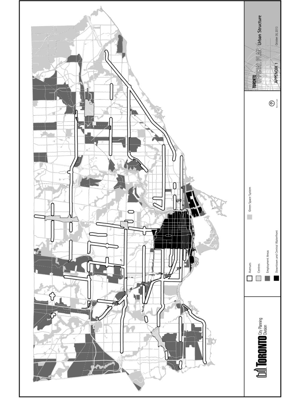
82 82
83 83

84 84
85 85
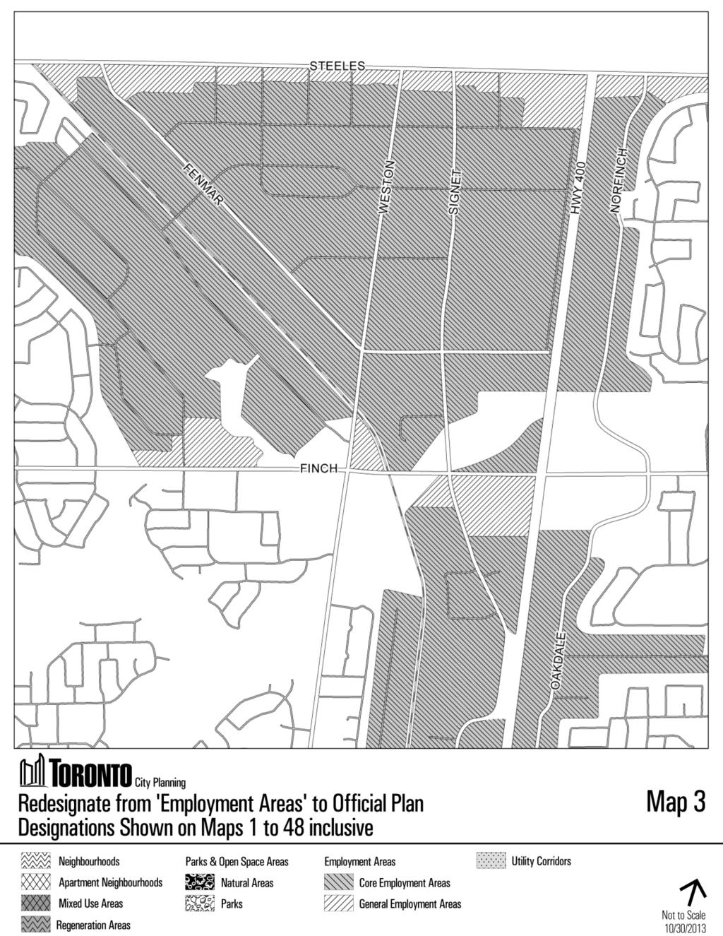
86 86
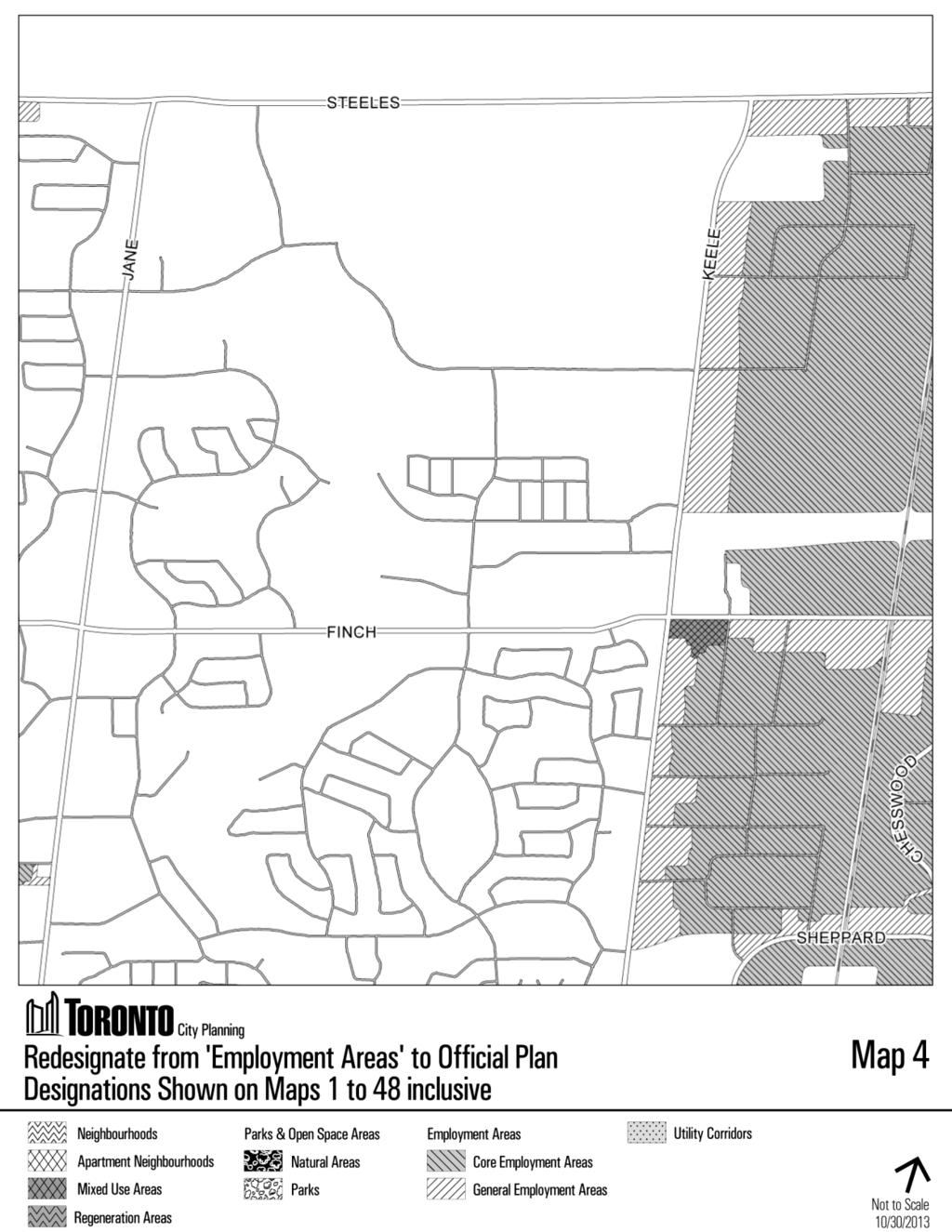
87 87
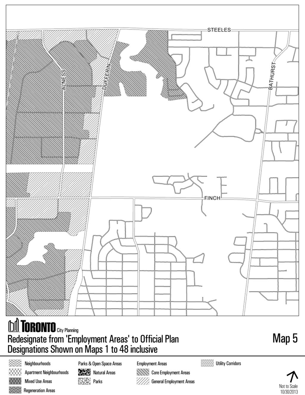
88 88
89 89
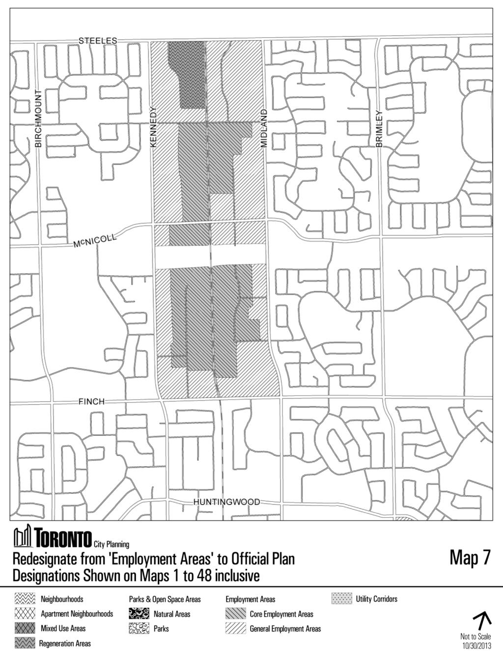
90 90
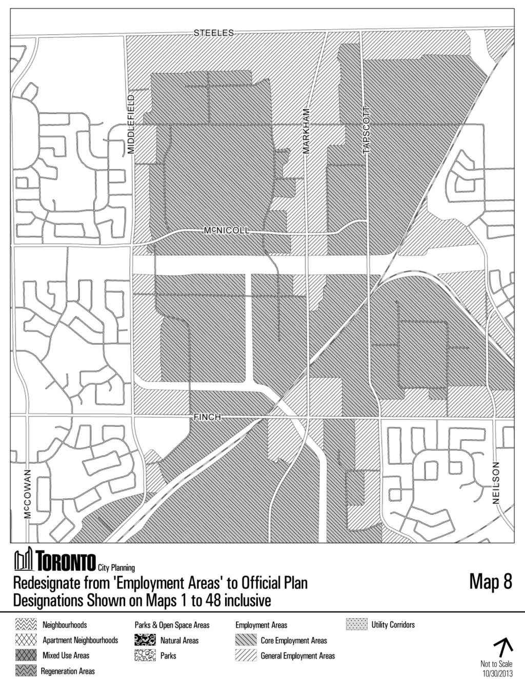
91 91
92 92
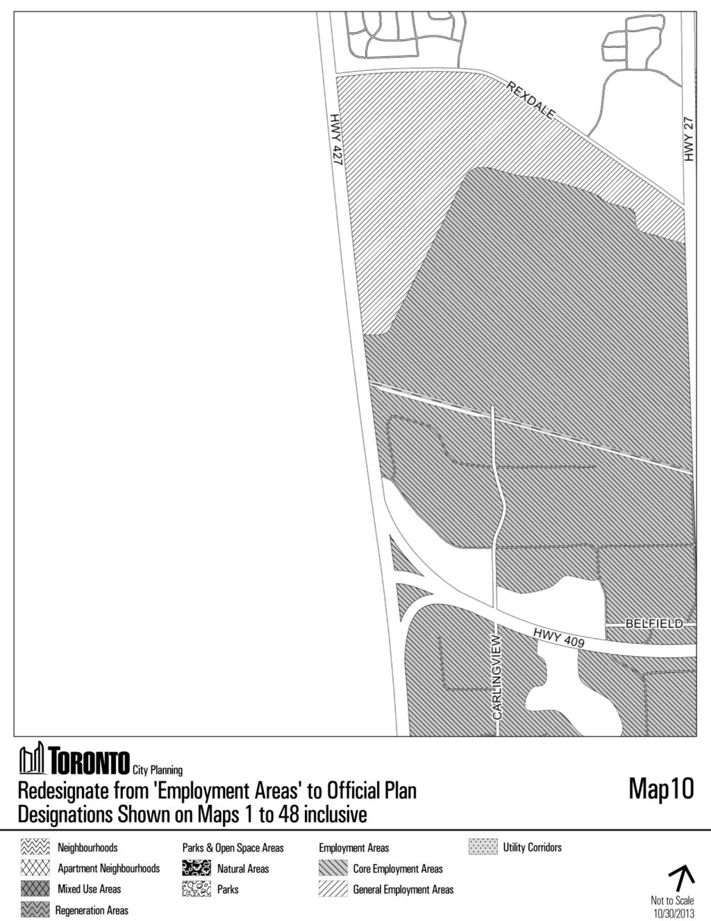
93 93
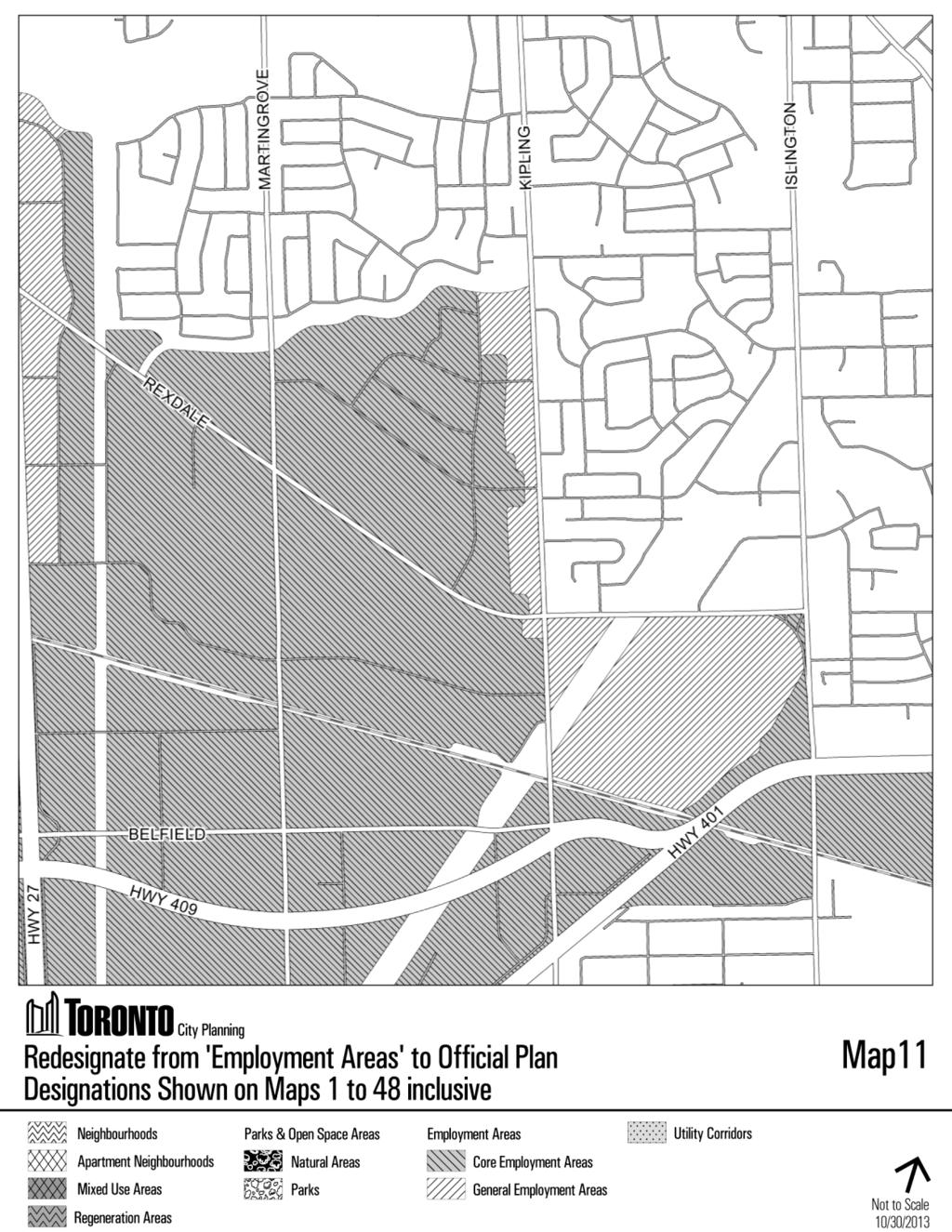
94 94
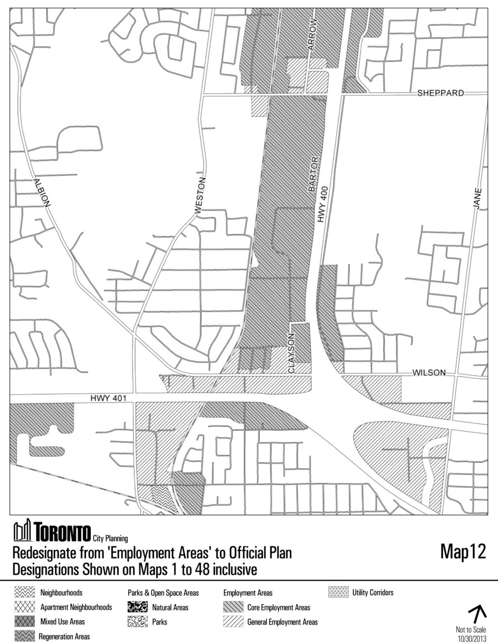
95 95
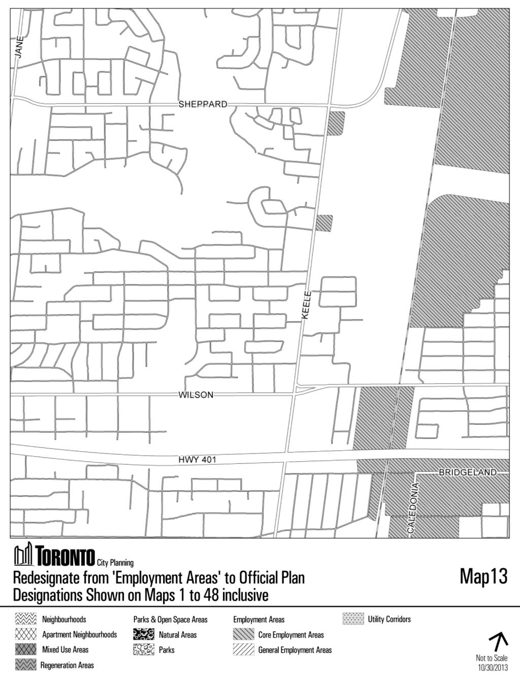
96 96
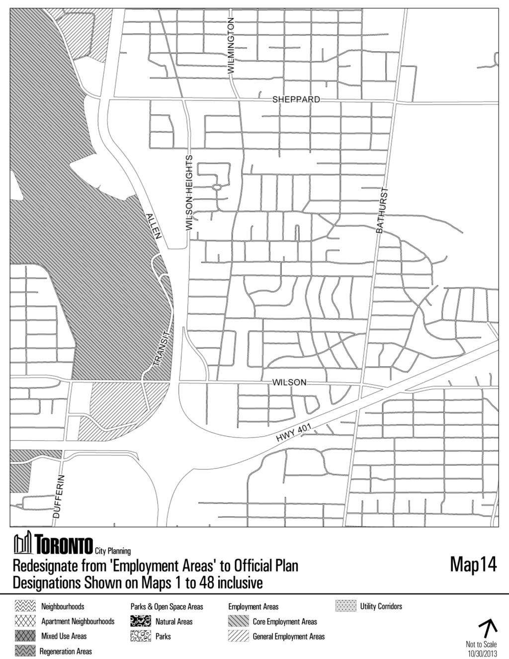
97 97
98 98
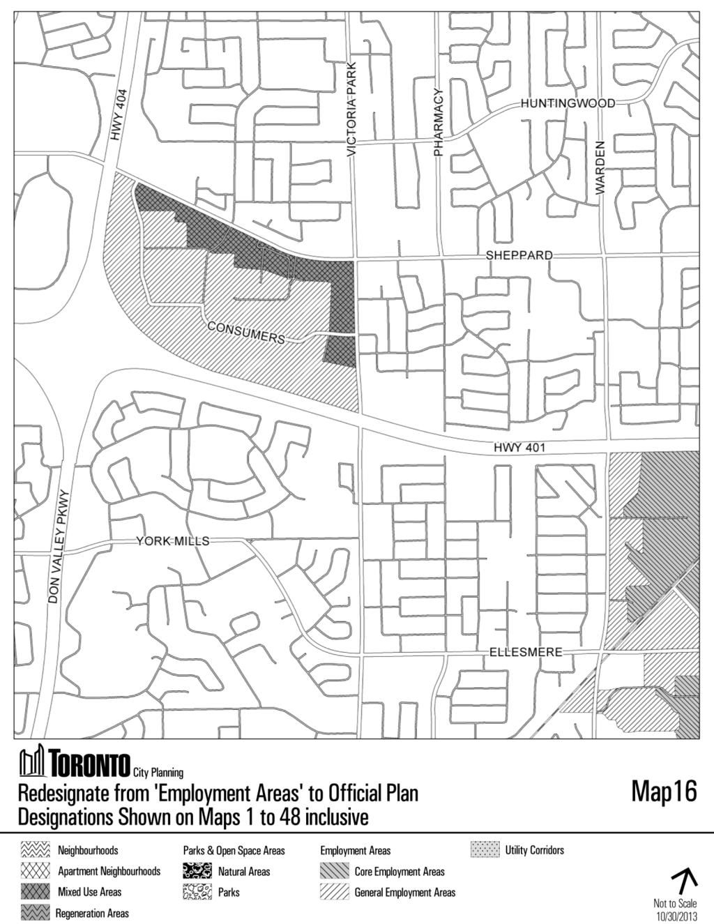
99 99
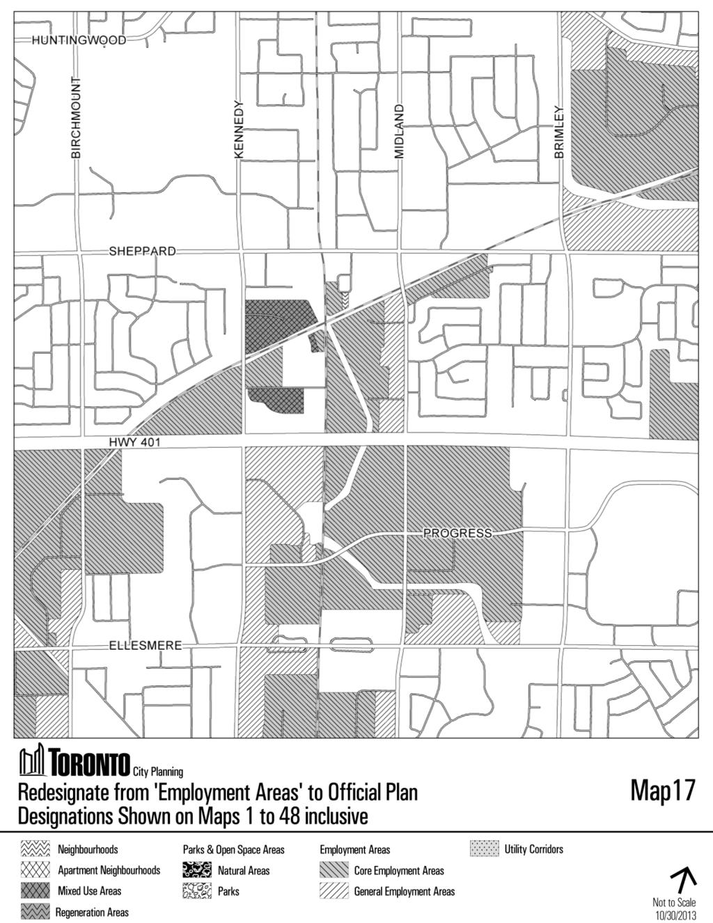
100 100
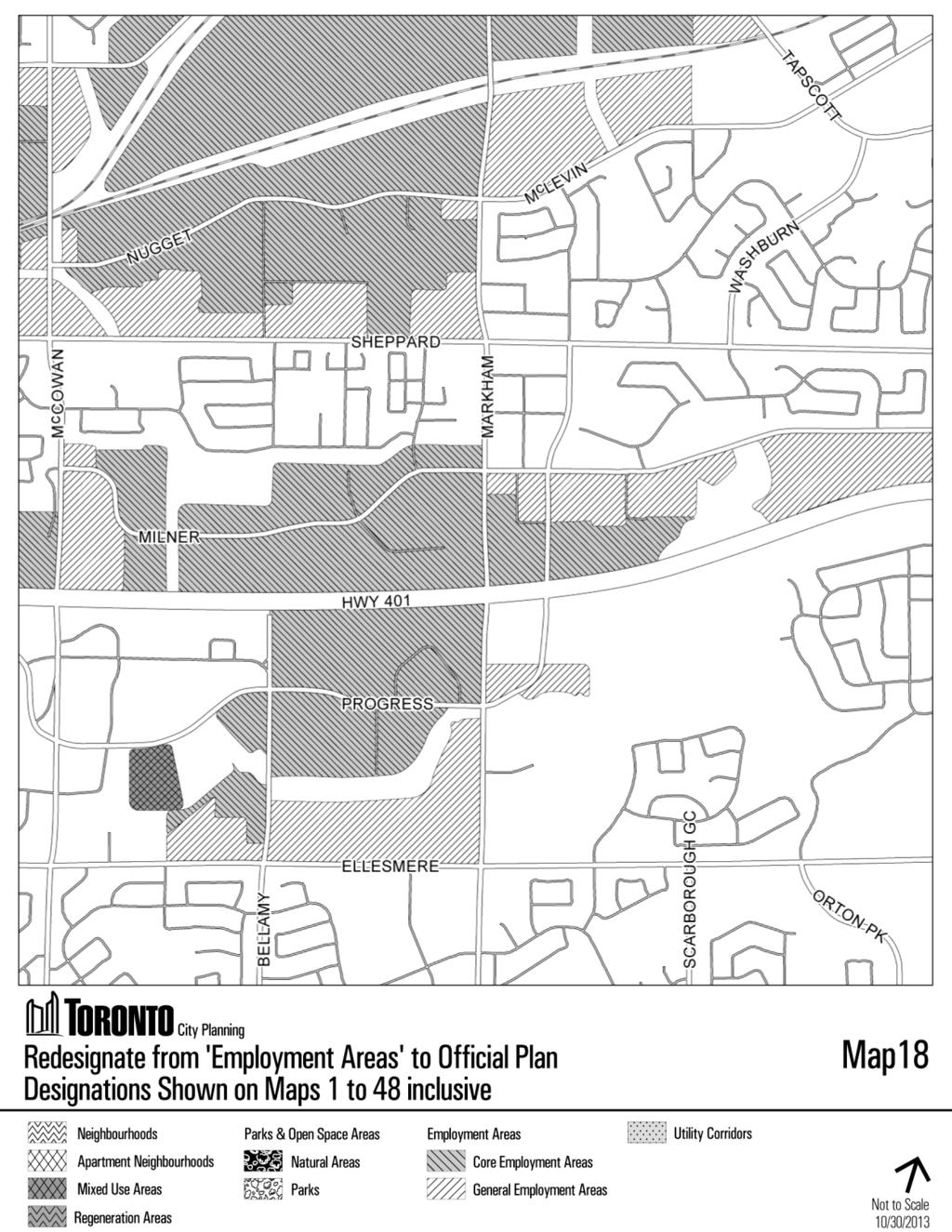
101 101
102 102
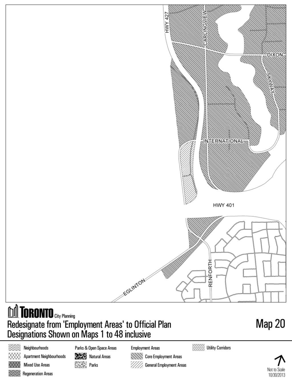
103 103
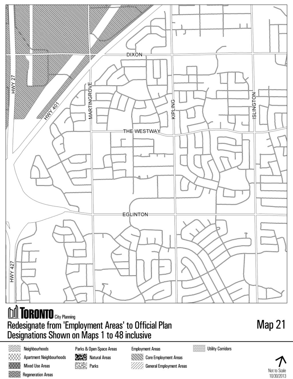
104 104
105 105
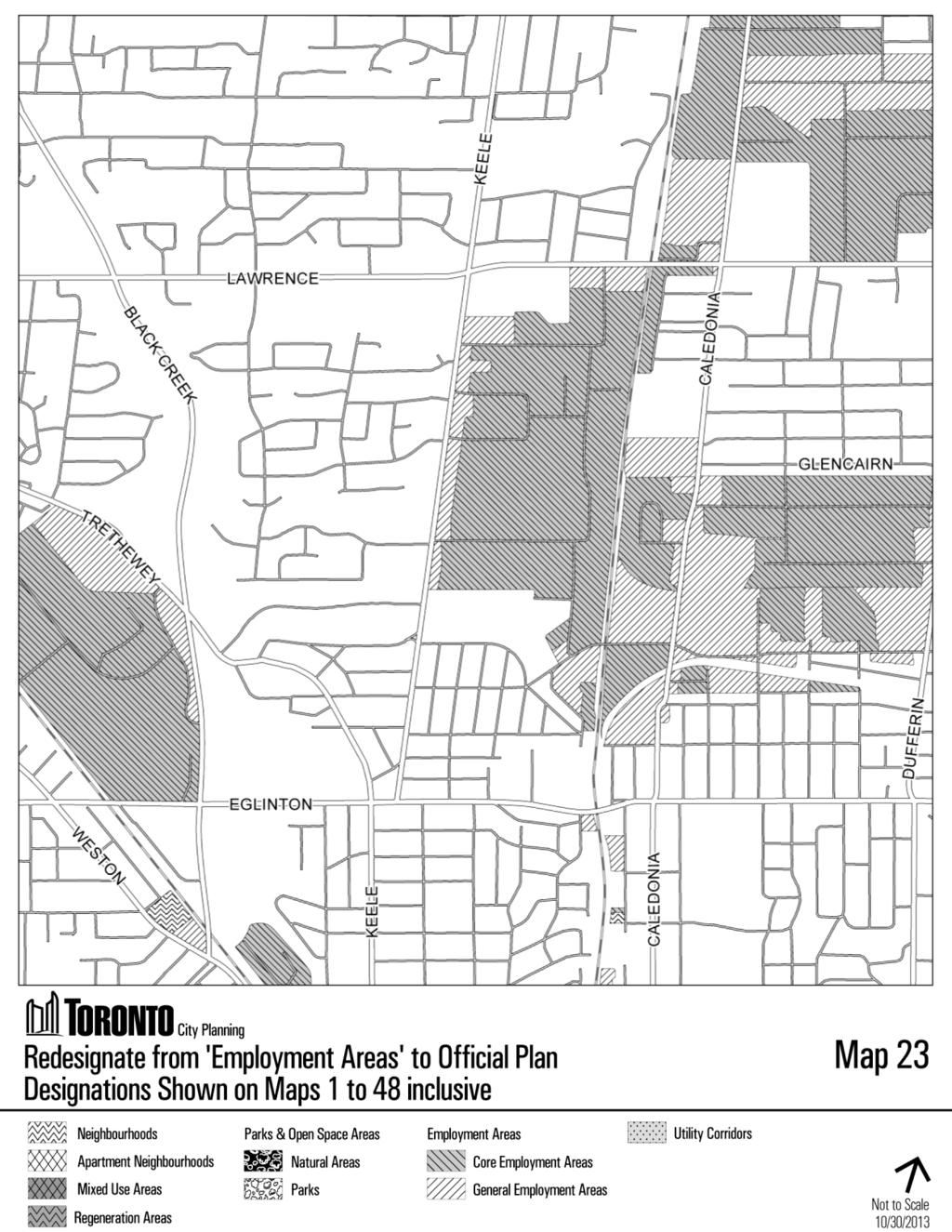
106 106
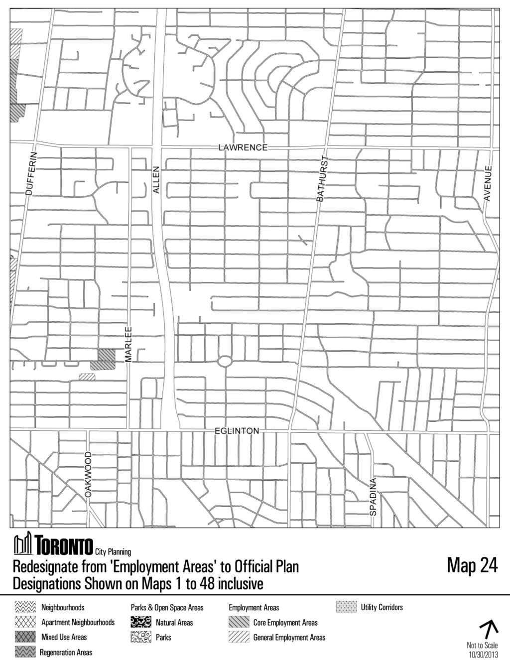
107 107
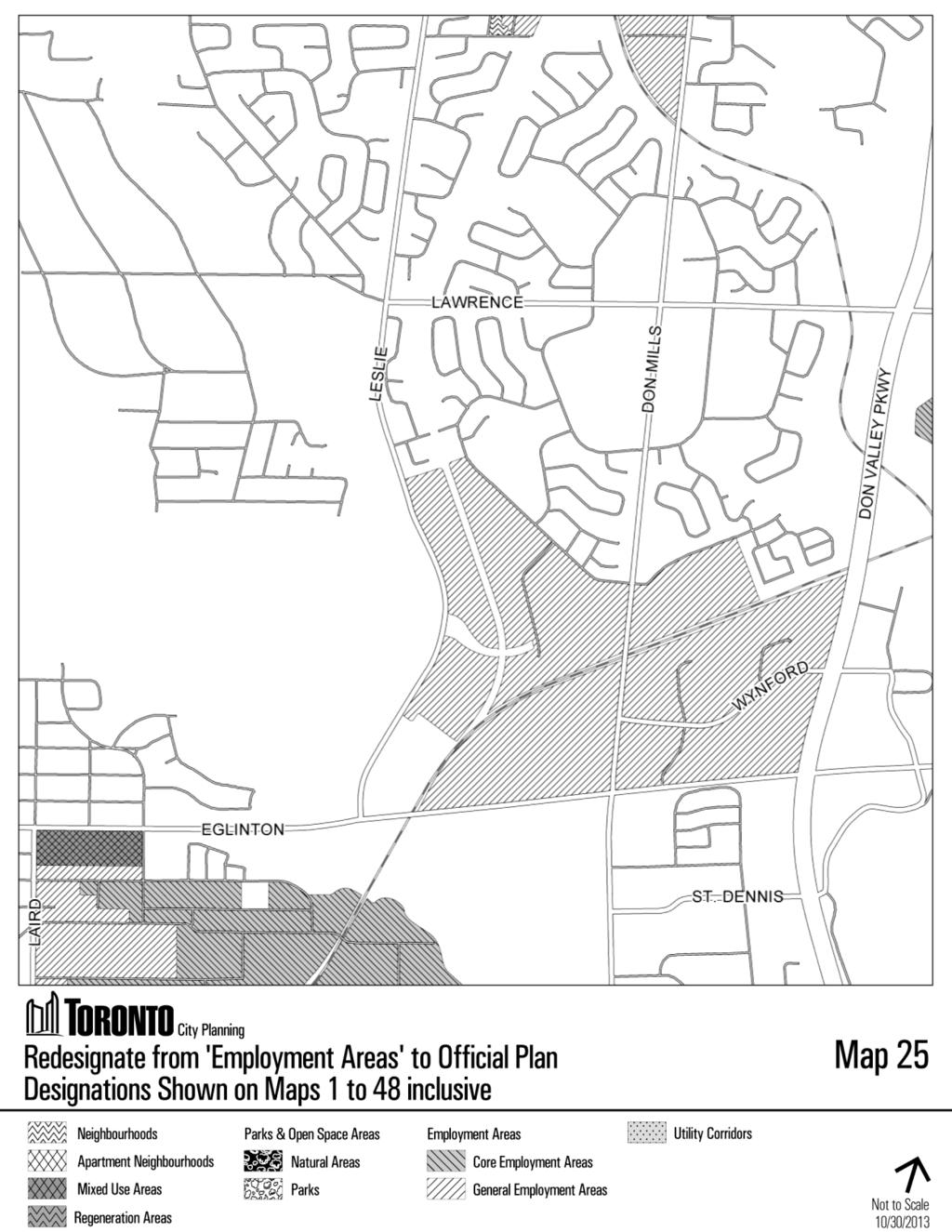
108 108
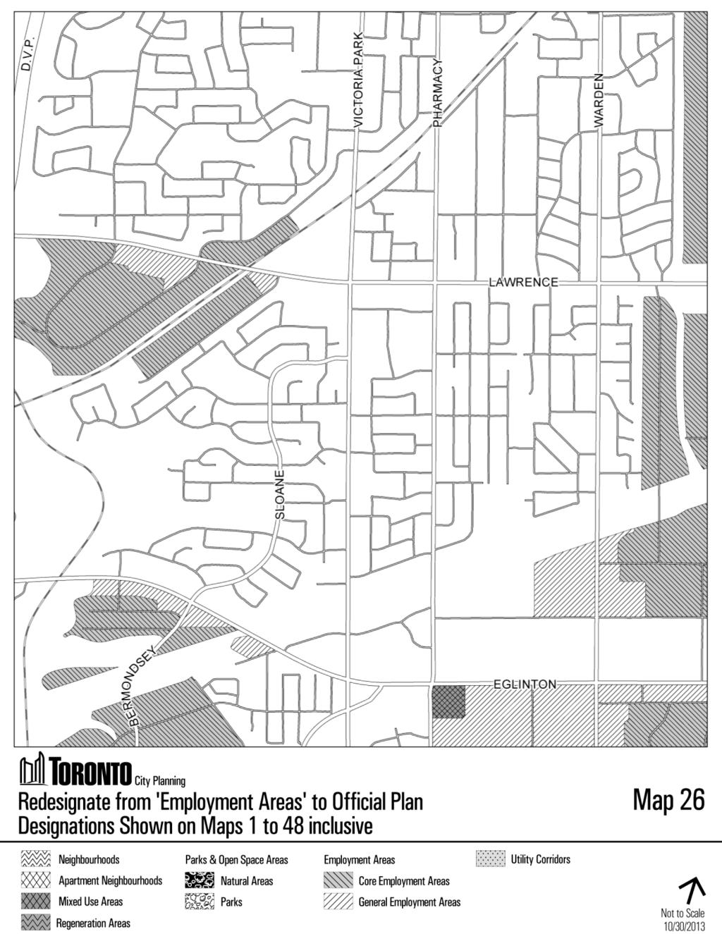
109 109
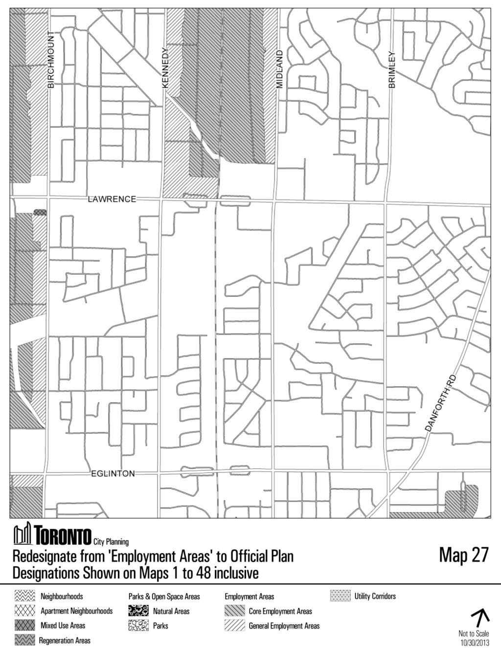
110 110
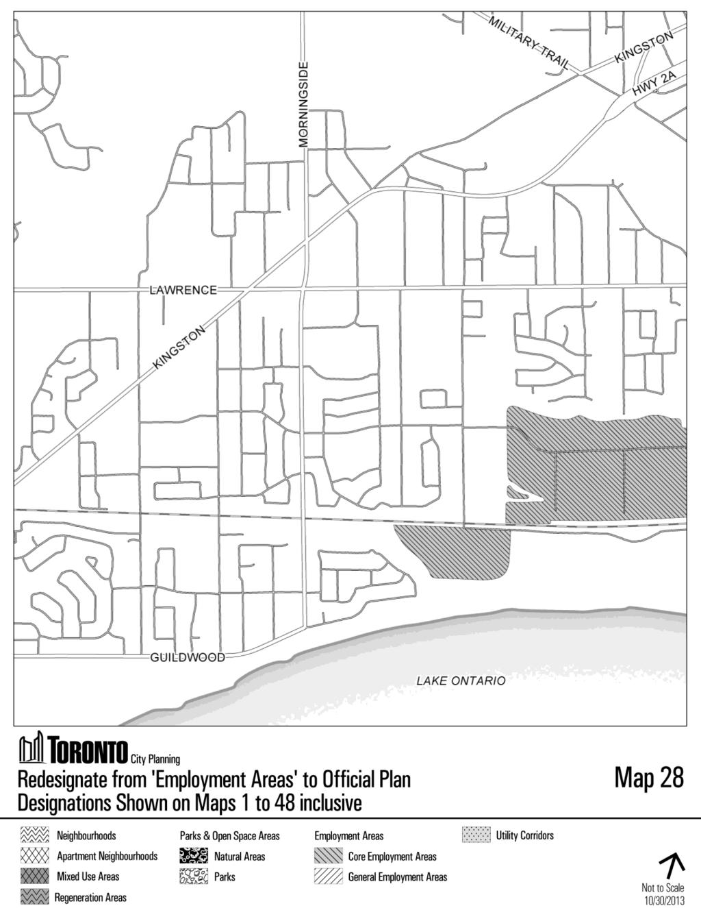
111 111
112 112
113 113
114 114
115 115
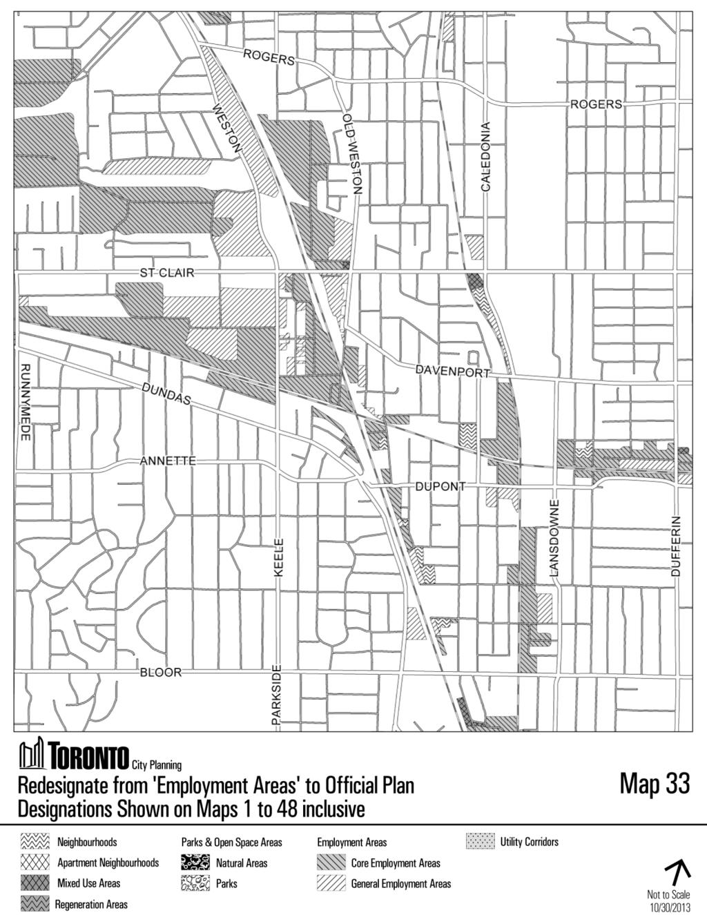
116 116
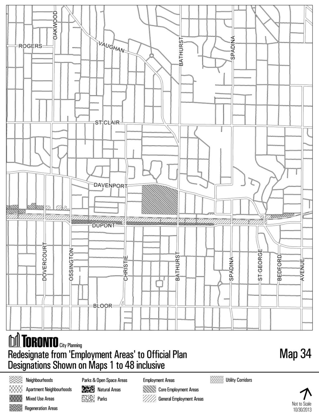
117 117
118 118
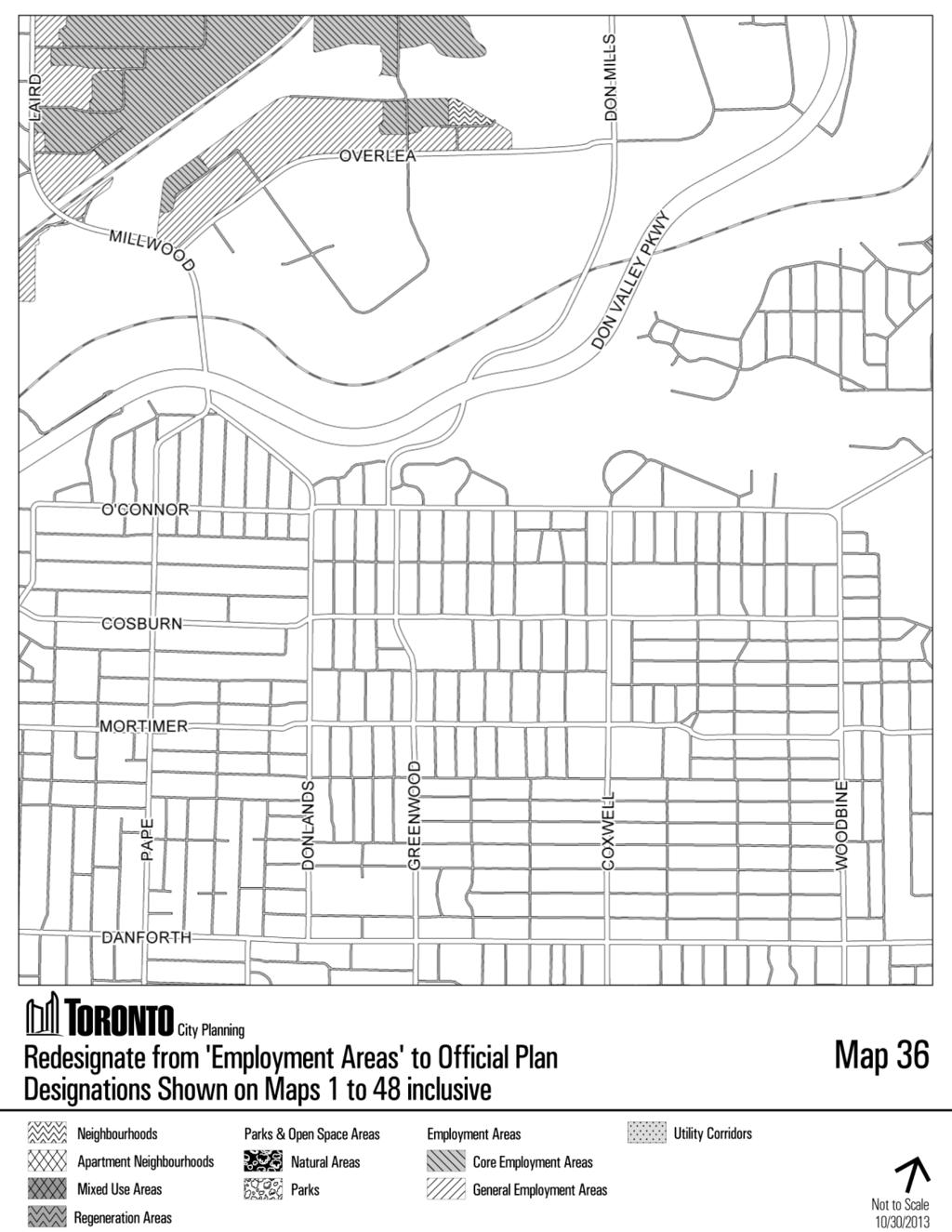
119 119
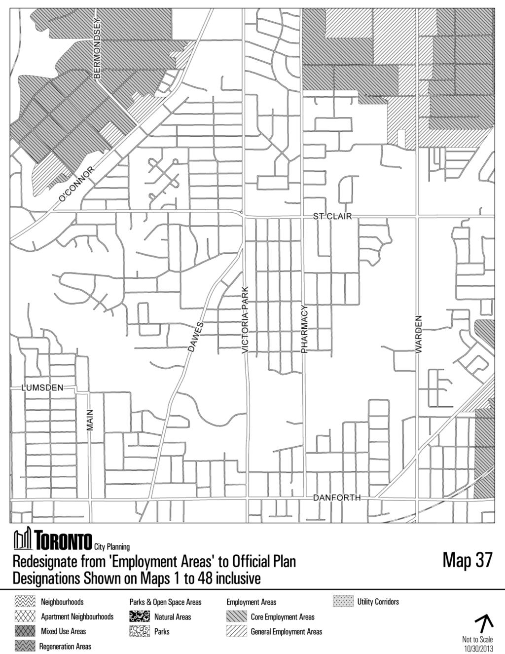
120 120
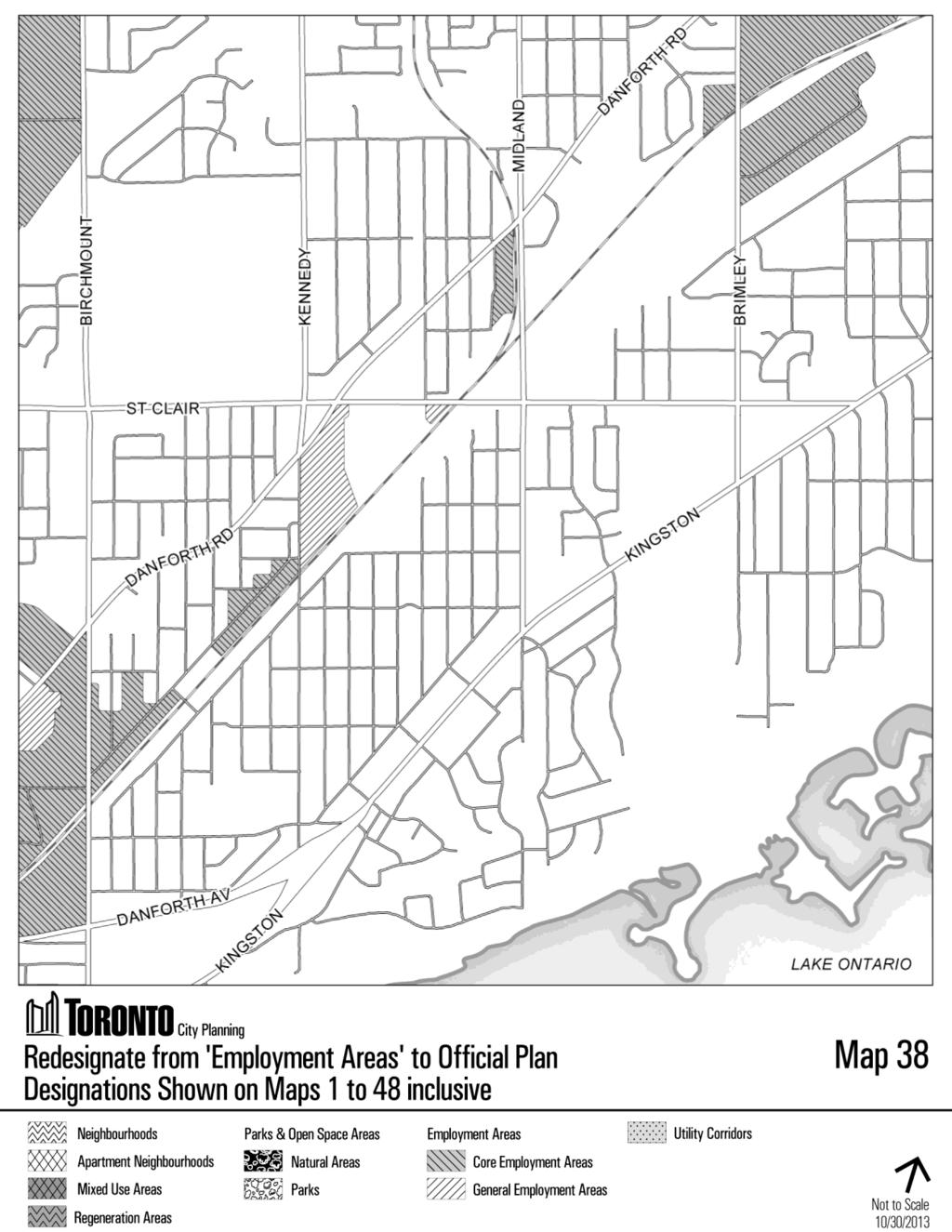
121 121
122 122
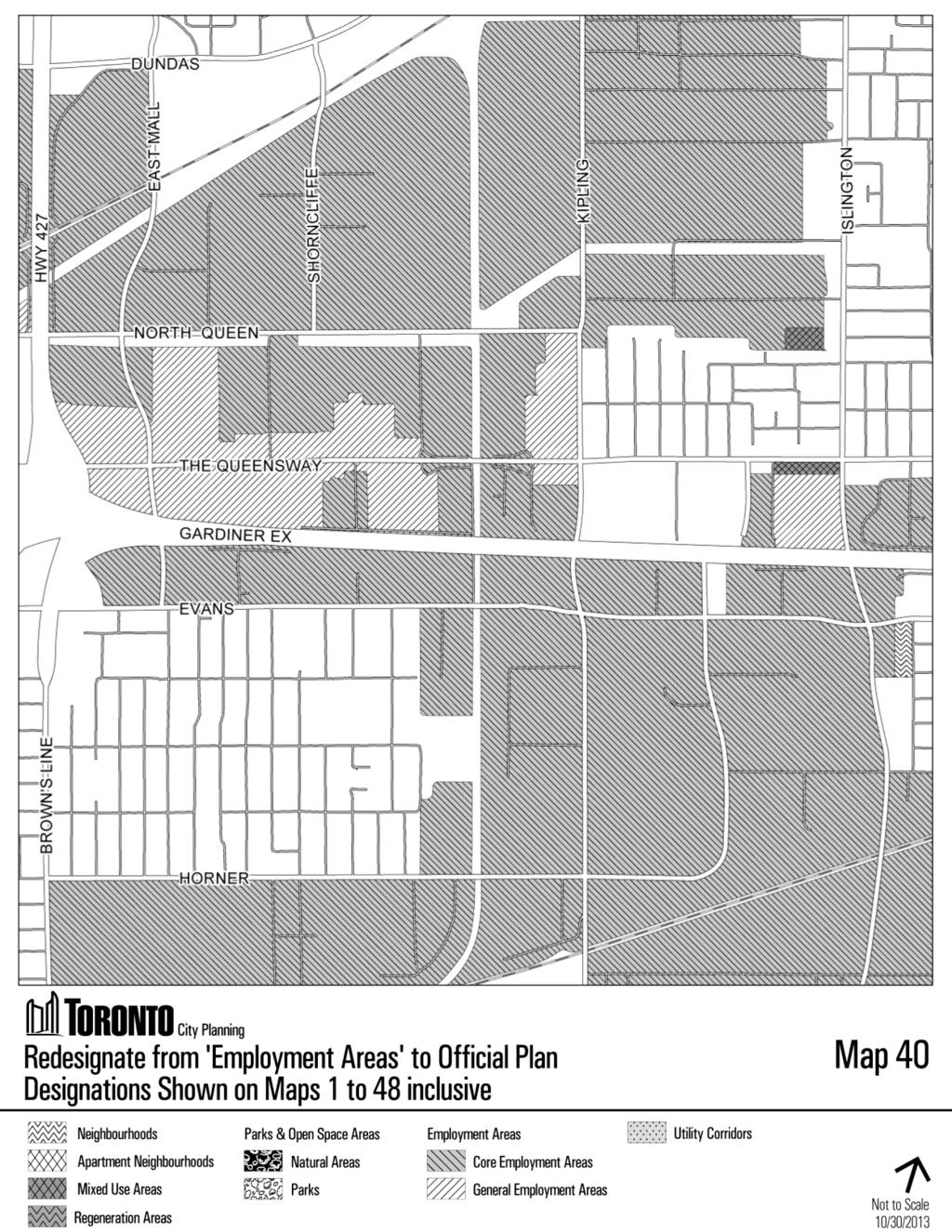
123 123
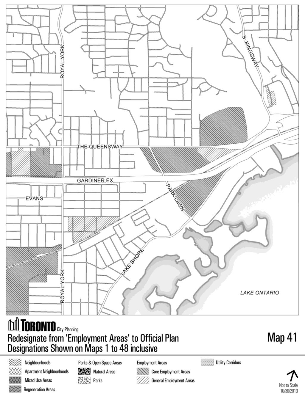
124 124
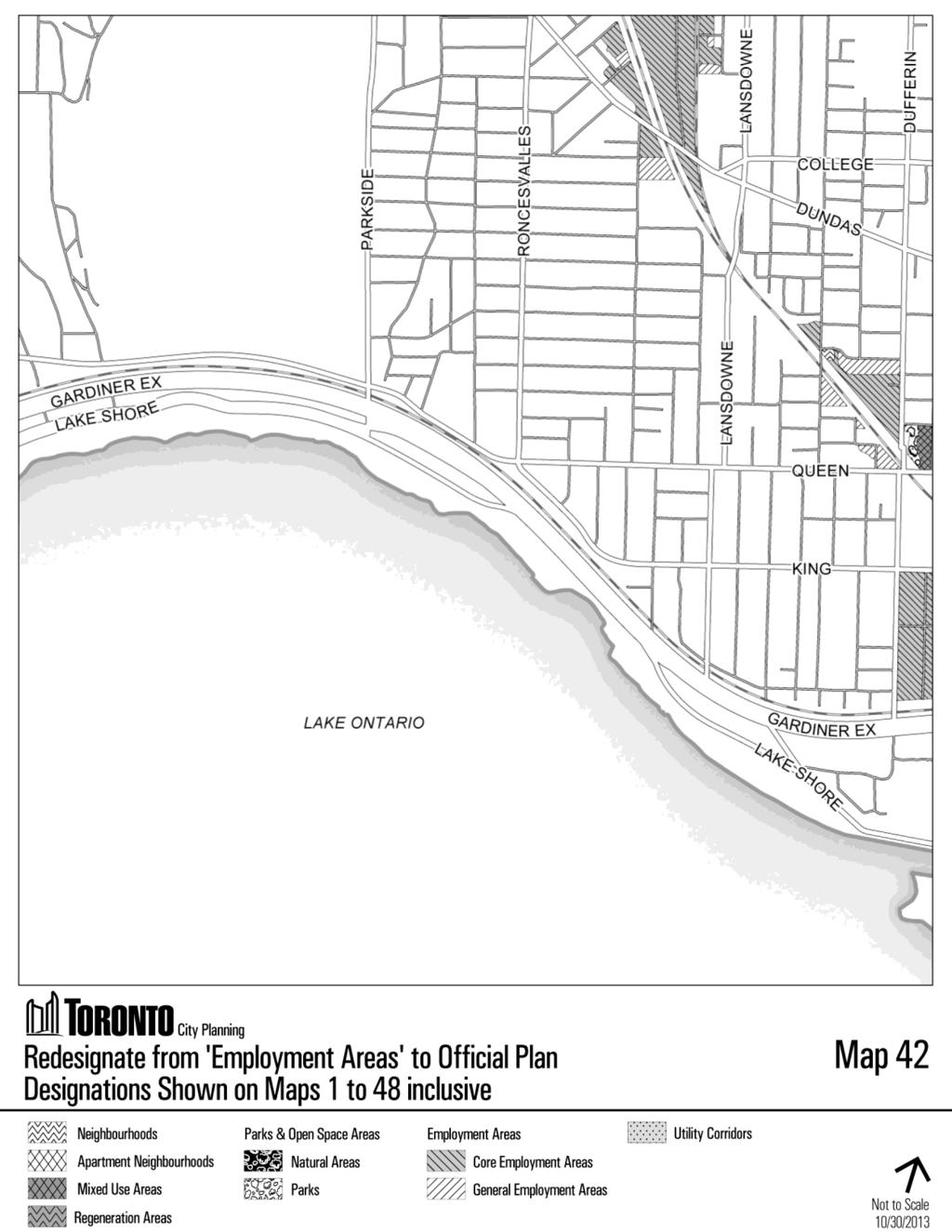
125 125
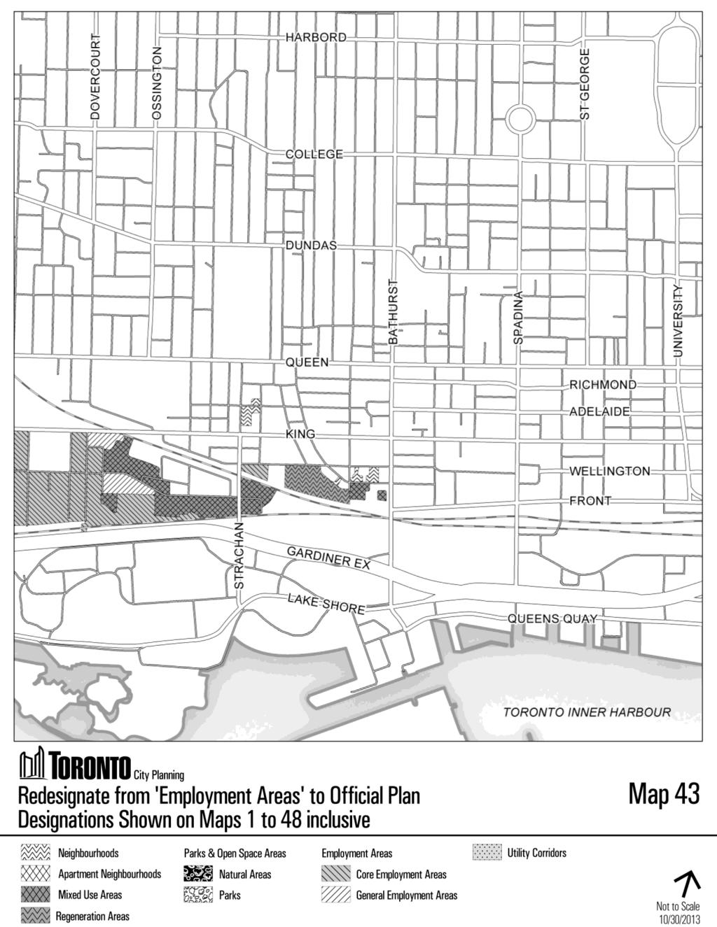
126 126
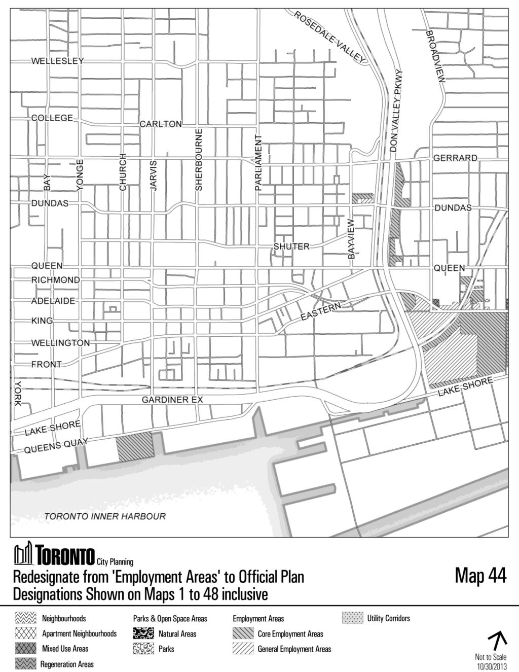
127 127
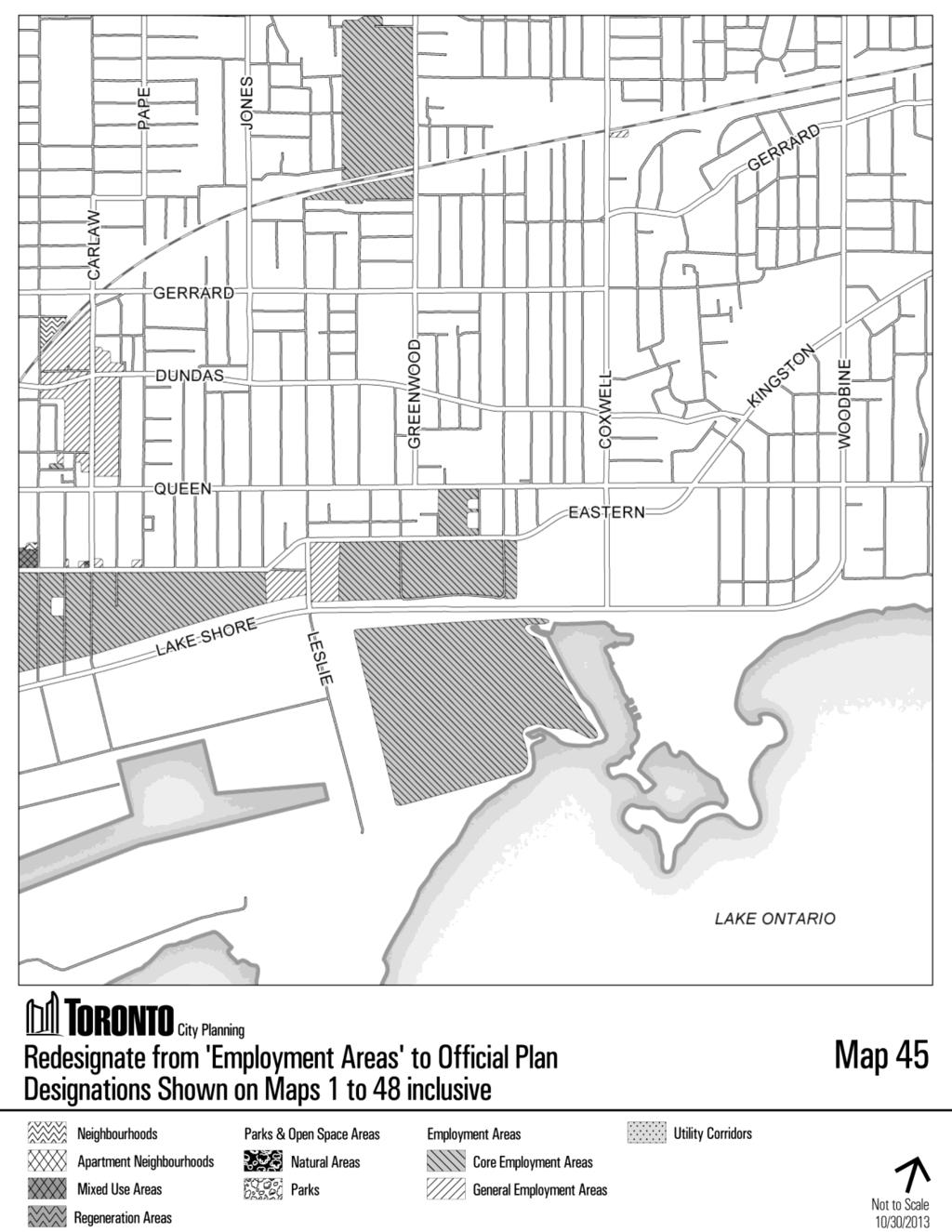
128 128
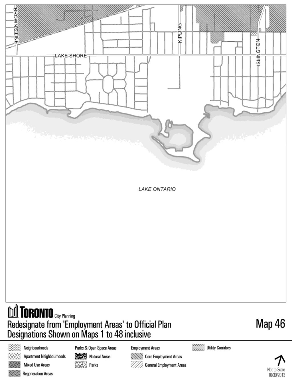
129 129
Planning and Growth Management Committee Item 28.2, adopted as amended, by City of Toronto Council on December 16, 17 and 18, 2013 CITY OF TORONTO
 Authority: Planning and Growth Management Committee Item 28.2, adopted as amended, by City of Toronto Council on December 16, 17 and 18, 2013 CITY OF TORONTO BY-LAW No. 1714-2013 To adopt Amendment No.
Planning and Growth Management Committee. Chief Planner and Executive Director, City Planning Division. Pg12013 (File No NNY 34 OZ)
") 865 York Mills Road Official Plan Amendment Application Preliminary Report STAFF REPORT ACTION REQUIRED Date: February 28, 2012 To: From: Wards: Reference Number: Planning and Growth Management Committee
865 York Mills Road Official Plan Amendment Application Preliminary Report STAFF REPORT ACTION REQUIRED Date: February 28, 2012 To: From: Wards: Reference Number: Planning and Growth Management Committee
and services The protection and conservation of environmentally significant and sensitive natural heritage features and functions.
 6. Land Use 6.0 Preamble A healthy and livable city is one in which people can enjoy a vibrant economy and a sustainable healthy environment in safe, caring and diverse neighbourhoods. In order to ensure
Planning for a Strong and Diverse Economy: Official Plan/Municipal Comprehensive Reviews - Draft Policies and Designations for Employment
 STAFF REPORT ACTION REQUIRED Planning for a Strong and Diverse Economy: Official Plan/Municipal Comprehensive Reviews - Draft Policies and Designations for Employment Date: October 23, 2012 To: From: Wards:
PORT WHITBY COMMUNITY
 PORT WHITBY COMMUNITY SECONDARY PLAN UPDATE COMMUNITY IMPROVEMENT PLAN URBAN DESIGN GUIDELINES September 2015 DRAFT PROPOSED AMENDMENT NUMBER # to the Whitby Official Plan PURPOSE: The intent of this Amendment
The West Vaughan Employment Area Secondary Plan Policies
 Part 2: The West Vaughan Employment Area Secondary Plan Policies 2.1 General Policies It is the policy of Council: 2.1.1. That the West Vaughan Employment Area (the WVEA), identified on Schedule 1, will
QUEEN-RIVER SECONDARY PLAN
 34 QUEEN-RIVER SECONDARY PLAN 34. QUEEN RIVER SECONDARY PLAN 1. INTRODUCTION The Queen-River area is approximately 6.4 hectares and is located at the eastern edge of the Downtown as shown on Map 34-1.
KING-SPADINA SECONDARY PLAN
 16 KING-SPADINA SECONDARY PLAN 16. KING-SPADINA SECONDARY PLAN 1. INERPREAION 1.1 he lands affected by this Secondary Plan for the King-Spadina Area are shown on Map 16-1. 1.2 Where a building within a
Planning and Growth Management Committee. Chief Planner and Executive Director, City Planning Division
 STAFF REPORT ACTION REQUIRED Planning for a Strong and Diverse Economy: Official Plan/Municipal Comprehensive Reviews - Proposed Economic Health Policies and Proposed Policies and Designations for Employment
Attachment 1, Schedule 1: Draft Official Plan Amendment. Planning and Growth Management Item ~ as adopted by City of Toronto Council on ~, 20~
 Attachment 1, Schedule 1: Draft Official Plan Amendment Authority: Planning and Growth Management Item ~ as adopted by City of Toronto Council on ~, 20~ Enacted by Council: ~, 20~ CITY OF TORONTO Bill
AGINCOURT SECONDARY PLAN
 1 AGINCOURT SECONDARY PLAN 1. AGINCOURT SECONDARY PLAN The following policies and principles apply to the area herein referred to as Agincourt, as outlined on Map 1-1. 1. GENERAL POLICIES 1.1 This Secondary
THE CITY OF VAUGHAN BY-LAW BY-LAW NUMBER A By-law to adopt Amendment Number 1 to the Official Plan of the Vaughan Planning Area.
 THE CITY OF VAUGHAN BY-LAW BY-LAW NUMBER 015-2014 A By-law to adopt Amendment Number 1 to the Official Plan of the Vaughan Planning Area. NOW THEREFORE the Council of the Corporation of the City of Vaughan
This page has been intentionally left blank.
 This page has been intentionally left blank. Chapter 3 3-2 3. Employment 3.A Niagara Economic Gateway 3.A.1 General The Niagara Economic Gateway comprises: a) The Gateway Economic Zone which includes all
13 THORNHILL YONGE STREET STUDY IMPLEMENTATION CITY OF VAUGHAN OPA 669 AND TOWN OF MARKHAM OPA 154
 13 THORNHILL YONGE STREET STUDY IMPLEMENTATION CITY OF VAUGHAN OPA 669 AND TOWN OF MARKHAM OPA 154 The Planning and Economic Development Committee recommends the adoption of the recommendations contained
4. LAND USE DESIGNATIONS
 4. LAND USE DESIGNATIONS Land use designations are among the Official Plan s key implementation tools for achieving the growth strategy set out in Chapter Two to direct major growth to some parts of the
City of Toronto Official Plan Indicators
 City of Toronto Official Plan Indicators Attachment 1 2017 Gladki Planning Associates in association with Hemson Consulting & Studio Jaywall City of Toronto Official Plan Indicators 1 Introduction What
Mark-up of the effect of the proposed Bronte Village Growth Area OPA No.18 on the text of section 24, Bronte Village, of the Livable Oakville Plan
 Mark-up of the effect of the proposed Bronte Village Growth Area OPA No.18 on the text of section 24, Bronte Village, of the Livable Oakville Plan Notes: This document is provided for information purposes
Draft Urban Hamilton Official Plan. Amendment No. XX
 1 of 75 The following text, together with: Draft Appendix A Appendix B Volume 1, Schedule E-1 Urban Land Use Designations Appendix C Volume 1, Appendix A Parks Classification Map Appendix D Volume 1, Appendix
6 PORT SYDNEY SETTLEMENT AREA
 Section 6 Port Sydney Page 61 6 PORT SYDNEY SETTLEMENT AREA 6.1 Basis and Principles Village of Port Sydney Waterfront Community Existing Services 6.1.1 Port Sydney is an historic settlement that has developed
Eglinton Avenue East & 50 Thermos Road - Official Plan Amendment Application Preliminary Report
 STAFF REPORT ACTION REQUIRED 1966 2050 Eglinton Avenue East & 50 Thermos Road - Official Plan Amendment Application Preliminary Report Date: March 15, 2016 To: From: Wards: Reference Number: Scarborough
178 Carruthers Properties Inc.
 178 Carruthers Properties Inc. Planning Rationale for 178 Carruthers Avenue Site Plan Control Application June 2014 Table of Contents 1.0 Introduction 2.0 Overview of Subject Property 3.0 Current Zoning
16. KING-SPADINA SECONDARY PLAN
 16. KING-SPADINA SECONDARY PLAN 1. INERPREAION 1.1 he lands affected by this Secondary Plan for the King-Spadina Area are shown on Map 16-1. 1.2 Where a building within a Regeneration Areas designation
YONGE STEELES CORRIDOR SECONDARY PLAN. Young + Wright / IBI Group Architects Dillon Consulting Ltd. GHK International (Canada) Ltd.
 Ltd.") PART A: PREAMBLE 1.0 PURPOSE The purpose of this Secondary Plan is to provide a development framework for intensification of the Yonge/ Steeles corridor including the north side of Steeles Avenue West
PART A: PREAMBLE 1.0 PURPOSE The purpose of this Secondary Plan is to provide a development framework for intensification of the Yonge/ Steeles corridor including the north side of Steeles Avenue West
SCHEDULE 'A' TO BY-LAW as Amended by AMENDMENT NO. 90 TO THE WHITBY OFFICIAL PLAN
 SCHEDULE 'A' TO BY-LAW 6413-10 as Amended by 6553-11 AMENDMENT NO. 90 TO THE WHITBY OFFICIAL PLAN SECTION A: GROWTH PLAN CONFORMITY PURPOSE: LOCATION: BASIS: The purpose of this Amendment is to: conform
2.2.1 DOWNTOWN: THE HEART OF TORONTO
 2.2.1 DOWNTOWN: THE HEART OF TORONTO Toronto has only one downtown. It plays a vital role as the city s economic and cultural hub and is critical to the health and prosperity of the entire region that
11.4 Highway 400 North Employment Lands Secondary Plan APPROVED BY THE ONTARIO MUNICIPAL BOARD ON NOVEMBER 21, 2011
 11.4 Highway 400 North Employment Lands Secondary Plan APPROVED BY THE ONTARIO MUNICIPAL BOARD ON NOVEMBER 21, 2011 11.4.1 General 11.4.1.1. as approved by the Ontario Municipal Board on November 21, 2011,
EXISTING COMPREHENSIVE PLAN
 EXISTING COMPREHENSIVE PLAN Town Center Land Use Element: V. LAND USE POLICIES Town Center Mercer Island's business district vision as described in "Your Mercer Island Citizen-Designed Downtown" was an
Employment and Commercial Review Analysis of Policy Directions
 Employment and Commercial Review Analysis of Policy Directions Appendix A The following analysis is town staff s response to the policy directions provided by the consultants who prepared the Employment
Welcome. Walk Around. Talk to Us. Write Down Your Comments
 Welcome This is an information meeting introducing the applications for proposed redevelopment of the Yorkdale Shopping Centre site at 3401 Dufferin Street and 1 Yorkdale Road over the next 20+ years,
ELMVALE ACRES SHOPPING CENTRE MASTER PLAN
 ELMVALE ACRES SHOPPING CENTRE MASTER PLAN Contents 1.0 INTRODUCTION... 2 2.0 LOCATION... 2 3.0 EXISTING CONTEXT... 2 4.0 VISION & GUIDING PRINCIPLES... 2 5.0 LAND USE AND BUILT FORM... 4 5.1 St. Laurent
SECTION ONE: INTRODUCTION. introduction
 introduction 1 INTRODUCTION Since it was first established in 1843 as a trading post for the Hudson s Bay Company, Victoria has evolved into a Provincial capital city that is recognized across Canada and
Official Plan Review: Draft Built Form Policies
 PG.30.1 REPORT FOR ACTION Official Plan Review: Draft Built Form Policies Date: May 15, 2018 To: Planning and Growth Management Committee From: Chief Planner and Executive Director, City Planning Division
Director, Community Planning, North York District
 STAFF REPORT ACTION REQUIRED Oakwood Avenue Arts District Official Plan Amendment Final Report Date: September 12, 2008 To: From: Wards: Reference Number: North York Community Council Director, Community
and Richmond Street West - Official Plan Amendment Application - Preliminary Report
 STAFF REPORT ACTION REQUIRED 822-838 and 860-862 Richmond Street West - Official Plan Amendment Application - Preliminary Report Date: August 14, 2017 To: From: Wards: Reference Number: Toronto and East
8 & 10 Donalda Crescent Official Plan & Rezoning Application Final Report
 STAFF REPORT ACTION REQUIRED 8 & 10 Donalda Crescent Official Plan & Rezoning Application Final Report Date: July 26, 2010 To: From: Wards: Reference Number: Scarborough Community Council Director, Community
CITY CLERK. Parkland Acquisition Strategic Directions Report (All Wards)
") CITY CLERK Clause embodied in Report No. 10 of the, as adopted by the Council of the City of Toronto at its meeting held on November 6, 7 and 8, 2001. 10 Parkland Acquisition Strategic Directions Report
CITY CLERK Clause embodied in Report No. 10 of the, as adopted by the Council of the City of Toronto at its meeting held on November 6, 7 and 8, 2001. 10 Parkland Acquisition Strategic Directions Report
Urban Design Manual PLANNING AROUND RAPID TRANSIT STATIONS (PARTS) Introduction. Station Study Areas
 Introduction. Station Study Areas") 111111 PLANNING AROUND RAPID TRANSIT STATIONS (PARTS) Introduction The ION rapid transit system will link Waterloo, Kitchener and Cambridge through a central transit corridor (CTC). There are a number
111111 PLANNING AROUND RAPID TRANSIT STATIONS (PARTS) Introduction The ION rapid transit system will link Waterloo, Kitchener and Cambridge through a central transit corridor (CTC). There are a number
FORMER CANADIAN FORCES BASE (CFB) ROCKCLIFFE SECONDARY PLAN. Official Plan Amendment XX to the Official Plan for the City of Ottawa
 ROCKCLIFFE SECONDARY PLAN. Official Plan Amendment XX to the Official Plan for the City of Ottawa") FORMER CANADIAN FORCES BASE (CFB) ROCKCLIFFE SECONDARY PLAN Official Plan Amendment XX to the Official Plan for the City of Ottawa 1 INDEX THE STATEMENT OF COMPONENTS PART A THE PREAMBLE PAGE Purpose...
FORMER CANADIAN FORCES BASE (CFB) ROCKCLIFFE SECONDARY PLAN Official Plan Amendment XX to the Official Plan for the City of Ottawa 1 INDEX THE STATEMENT OF COMPONENTS PART A THE PREAMBLE PAGE Purpose...
Queen Street West - Zoning Amendment Application - Preliminary Report
 STAFF REPORT ACTION REQUIRED 944-952 Queen Street West - Zoning Amendment Application - Preliminary Report Date: February 6, 2013 To: From: Wards: Reference Number: Toronto and East York Community Council
6. REGIONAL AND COMMUNITY FACILITIES DESIGNATIONS 6.1. OBJECTIVES FOR REGIONAL AND COMMUNITY FACILITIES LAND USE DESIGNATIONS
 6. REGIONAL AND COMMUNITY FACILITIES DESIGNATIONS INTRODUCTION The Regional and land use designations provide the primary locations for uses which satisfy the health, education and other service needs
Policies and Code Intent Sections Related to Town Center
 Policies and Code Intent Sections Related to Town Center The Town Center Vision is scattered throughout the Comprehensive Plan, development code and the 1994 Town Center Plan. What follows are sections
2. Shaping Waterloo Region s Urban Communities
 2. Much of the region s growth over the past several decades has occurred in suburban areas that separated where people live from where they work and shop. This pattern of growth has increased the need
8 Oak Street - Official Plan and Zoning By-law Amendment Application - Preliminary Report
 STAFF REPORT ACTION REQUIRED 8 Oak Street - Official Plan and Zoning By-law Amendment Application - Preliminary Report Date: March 17, 2014 To: From: Wards: Reference Number: Planning and Growth Management
22 Metropolitan Rd - Official Plan Amendment Application - Preliminary Report
 STAFF REPORT ACTION REQUIRED 22 Metropolitan Rd - Official Plan Amendment Application - Preliminary Report Date: January 29, 2013 To: From: Wards: Planning and Growth Management Committee Chief Planner
DAVENPORT VILLAGE SECONDARY PLAN
 27 DAVENPORT VILLAGE SECONDARY PLAN 27. DAVENPORT VILLAGE SECONDARY PLAN 1. VISION FOR THE DAVENPORT VILLAGE SECONDARY PLAN Davenport Village, municipally known as 830, 940, 980 and 1100 Lansdowne Avenue,
4800 Yonge Street - Official Plan Amendment, Zoning Amendment and Site Plan Applications - Request for Direction Report
 STAFF REPORT ACTION REQUIRED 4800 Yonge Street - Official Plan Amendment, Zoning Amendment and Site Plan Applications - Request for Direction Report Date: April 16, 2018 To: From: Wards: Reference Number:
Midtown Oakville will be a vibrant, transit-supportive, mixed use urban community and employment area.
 Livable Oakville Part E: Growth Areas, Special Policy Areas and Exceptions 20. MIDTOWN OAKVILLE 20.1 Goal The interchange of Trafalgar Road and the QEW and the Oakville GO Station are major entry points
5 Direct Growth. 5.1 Introduction
 5 Direct Growth 5.1 Introduction Mississauga s population and employment growth prospects are expected to remain strong over the next 25 years. Mississauga has sufficient land to accommodate projected
9 CITY OF VAUGHAN OFFICIAL PLAN AMENDMENT NO BOCA EAST INVESTMENTS LIMITED
 9 CITY OF VAUGHAN OFFICIAL PLAN AMENDMENT NO. 631 - BOCA EAST INVESTMENTS LIMITED The Planning and Economic Development Committee recommends the adoption of the recommendations contained in the following
Dufferin-Wilson Regeneration Area Study City Initiated Official Plan Amendment Supplementary Report # 2
 STAFF REPORT ACTION REQUIRED Dufferin-Wilson Regeneration Area Study City Initiated Official Plan Amendment Supplementary Report # 2 Date: November 7, 2017 To: From: Wards: Reference Number: City Council
1296 Kennedy Road - Zoning Amendment Application - Preliminary Report
 STAFF REPORT ACTION REQUIRED 1296 Kennedy Road - Zoning Amendment Application - Preliminary Report Date: January 15, 2016 To: From: Wards: Reference Number: Scarborough Community Council Acting Director,
Clairtrell Area Context Plan
 Clairtrell Area Context Plan March 2005 Urban Development Services City Planning Contents 1. Introduction... 4 2. Development Structure... 6 2.1 Streets... 7 2.1.1 Sheppard Avenue and Bayview Avenue...
30 and 44 Zorra Street - Zoning By-law Amendment Application - Preliminary Report
 STAFF REPORT ACTION REQUIRED 30 and 44 Zorra Street - Zoning By-law Amendment Application - Preliminary Report Date: March 14, 2016 To: From: Wards: Reference Number: Etobicoke York Community Council Director,
844 Don Mills Road & 1150 Eglinton Avenue East - Official Plan Amendment Application - Preliminary Report
 STAFF REPORT ACTION REQUIRED 844 Don Mills Road & 1150 Eglinton Avenue East - Official Plan Amendment Application - Preliminary Report Date: July 10, 2014 To: From: Wards: Reference Number: Planning and
CITY OF LANGLEY OFFICIAL COMMUNITY PLAN BYLAW, 2005, NO APPENDIX II - REGIONAL CONTEXT MAP
 CITY OF LANGLEY OFFICIAL COMMUNITY PLAN BYLAW, 2005, NO. 2600 APPENDIX II - REGIONAL CONTEXT MAP ± Legend Agricultural Mixed Employment Industrial Conservation & Recreation Regional City Centre Urban Containment
6 Growth Management Challenges and Opportunities
 6 Growth Management Challenges and Opportunities The Town has established a goal of attaining a 50% participation rate with respect to employment opportunities versus residential population. The Town s
5.0 VILLAGE AREAS. February 2008 Municipality of West Elgin ~ Official Plan 5-1
 5.0 VILLAGE AREAS This section of the Official Plan deals with the villages of Rodney and West Lorne being the two largest and only fully serviced settlement areas in West Elgin and the most logical and
Bloor St. W. Rezoning - Preliminary Report
 STAFF REPORT ACTION REQUIRED 1638-1644 Bloor St. W. Rezoning - Preliminary Report Date: April 1, 2008 To: From: Wards: Reference Number: Toronto and East York Community Council Acting Director, Community
Sustainable Growth. Sustainable Growth
 2 Sustainable Growth Sustainable Growth SUSTAINABLE GROWTH 2.1 COMMUNITY VISION... 2-5 2.2 THE CITY SYSTEM... 2-7 2.2.1 AREAS... 2-7 2.2.2 CITY-WIDE SYSTEMS... 2-8 2.2.3 PROVINCIAL PLAN BOUNDARIES AND
CONTENTS 8.0 LAND USE 8.1 GENERAL LAND USE 8.2 RESIDENTIAL 8.3 MIXED USE 8.4 COMMERCIAL 8.5 EMPLOYMENT LANDS
 8-2 Land Use 8.0 LAND USE CONTENTS 8.1 GENERAL LAND USE 8.1.1 Uses provided for in all Land Use Designations 8.1.2 Uses prohibited in Hazardous Lands, Hazardous Sites and Special Policy Areas 8.1.3 Uses
240 and 242 Finch Avenue West Zoning By-law Amendment Application Preliminary Report
 REPORT FOR ACTION 240 and 242 Finch Avenue West Zoning By-law Amendment Application Preliminary Report Date: March 1, 2019 To: North York Community Council From: Director, Community Planning, North York
141 GEORGE STREET PLANNING RATIONALE
 141 GEORGE STREET PLANNING RATIONALE MINOR ZONING BY-LAW AMENDMENT NOVEMBER 2, 2016 PLANNING RATIONALE 223 McLeod Street Ottawa, ON K2P 0Z8 613.730.5709 fotenn.com INTRODUCTION FOTENN Consultants is acting
20 & 50 Ashtonbee Road, 1920 & 1940 Eglinton Avenue East, and 880, 890 & 900 Warden Avenue Zoning Amendment Application Final Report
 STAFF REPORT ACTION REQUIRED 20 & 50 Ashtonbee Road, 1920 & 1940 Eglinton Avenue East, and 880, 890 & 900 Warden Avenue Zoning Amendment Application Final Report Date: August 16, 2012 To: From: Wards:
Public Open House. Overview of the Downtown Plan Official Plan Amendment April 23, 2018
 Public Open House Overview of the Downtown Plan Official Plan Amendment April 23, 2018 1 A 25-Year Plan for Downtown To ensure growth contributes positively to Toronto s Downtown as a great place to live,
1 Introduction. Chapter. In this chapter:
 Chapter 1 Introduction In this chapter: 1.1 A Snapshot of the Region 1.2 Towards a Sustainable Region 1.3 The Provincial Context 1.4 Purpose and Organization The Regional Municipality of York Official
1071 King Street West Zoning Amendment Application - Preliminary Report
 STAFF REPORT ACTION REQUIRED 1071 King Street West Zoning Amendment Application - Preliminary Report Date: August 9, 2012 To: From: Wards: Reference Number: Toronto and East York Community Council Director,
AMENDMENT NO. 42 TO THE OFFICIAL PLAN OF THE TOWN OF GRIMSBY
 AMENDMENT NO. 42 TO THE OFFICIAL PLAN OF THE TOWN OF GRIMSBY INITIATED BY TOWN OF GRIMSBY TABLE OF CONTENTS PART I: THE CERTIFICATION Certification Page Adopting By-law of the Town of Grimsby PART II:
PILLAR FOUR INTEGRATE LAND USE & TRANSPORTATION
 PILLAR FOUR INTEGRATE LAND USE & TRANSPORTATION 8 Scarborough Centre on the Move Transportation Master Plan 123 8 Transportation Pillar Four Integrate Land Use & The fourth pillar focuses on the relationship
Chapter 4. Linking Land Use with Transportation. Chapter 4
 Chapter 4 Linking Land Use with Transportation Chapter 4 59 Chapter 4 Linking Land Use with Transportation Community Design and Transportation Program Introduction Since the 1950s, the predominant development
[PLANNING RATIONALE] For Site Plan Control and Lifting of Holding Zone By-Law 101 Champagne Avenue. May 23, 2014
![[PLANNING RATIONALE] For Site Plan Control and Lifting of Holding Zone By-Law 101 Champagne Avenue. May 23, 2014](/thumbs/75/71599615.jpg "[PLANNING RATIONALE] For Site Plan Control and Lifting of Holding Zone By-Law 101 Champagne Avenue. May 23, 2014") [PLANNING RATIONALE] For Site Plan Control and Lifting of Holding Zone By-Law 101 Champagne Avenue May 23, 2014 Contents 1.0 Introduction... 2 2.0 Site Context... 2 2.1 Adjacent Uses... 2 Figure 1: Site
[PLANNING RATIONALE] For Site Plan Control and Lifting of Holding Zone By-Law 101 Champagne Avenue May 23, 2014 Contents 1.0 Introduction... 2 2.0 Site Context... 2 2.1 Adjacent Uses... 2 Figure 1: Site
*** DRAFT 2 FOR PUBLIC REVIEW ***
 6.7 The area is generally bounded by the Red Hill Valley Parkway to the west, Lake Avenue to the east, the Queen Elizabeth Way (QEW) to the north, and by the properties just south of Queenston Road to
CHAIR AND MEMBERS PLANNING & ENVIRONMENT COMMITTEE JOHN M. FLEMING MANAGING DIRECTOR, PLANNING AND CITY PLANNER
 TO: FROM: SUBJECT: CHAIR AND MEMBERS PLANNING & ENVIRONMENT COMMITTEE JOHN M. FLEMING MANAGING DIRECTOR, PLANNING AND CITY PLANNER APPLICATION BY: THE CORPORATION OF THE CITY OF LONDON OUTDOOR PATIOS IN
Official Plan Review
 Official Plan Review Summary Report - The Built Environment August 2014 Part 1: Introduction Planning for a healthy, prosperous and sustainable community is an important goal for our municipality. From
TABLE OF CONTENTS 1.0 INTRODUCTION... 3
 TABLE OF CONTENTS 1.0 INTRODUCTION... 3 1.1. BACKGROUND... 3 1.2. THE PROPOSAL... 5 2.0 EXISTING POLICY FRAMEWORK... 5 2.1. PROVINCIAL POLICY STATEMENT (PPS)... 5 2.2. CITY OF LONDON OFFICIAL PLAN (OP)...
WITNESS STATEMENT Of. Ronald Blake. On behalf of the Intervenor The Corporation of the City of Markham
 Filed: 2013-06028 EB-2012-0451 Exhibit L.EGD.COM.2 Page 1 of 7 WITNESS STATEMENT Of Ronald Blake On behalf of the Intervenor The Corporation of the City of Markham In the matter of an application by Enbridge
The Proposed Auckland Unitary Plan (notified 30 September 2013)
") 3 Business zones Introduction There are 10 business zones in the Unitary Plan: City Centre Metropolitan Centre Town Centre Local Centre Neighbourhood Centre Mixed Use General Business Business Park Light
3 Business zones Introduction There are 10 business zones in the Unitary Plan: City Centre Metropolitan Centre Town Centre Local Centre Neighbourhood Centre Mixed Use General Business Business Park Light
The Corporation of the Town of Milton
 Report To: From: Council Barbara Koopmans, Commissioner, Planning and Development Date: May 7, 2018 Report No: Subject: Making it Possible Positioning the Town s Strategy for Growth and Economic Development
5959 Yonge Street Rezoning Application - Preliminary Report
 STAFF REPORT ACTION REQUIRED 5959 Yonge Street Rezoning Application - Preliminary Report Date: February 23, 2011 To: From: Wards: Reference Number: North York Community Council Director, Community Planning,
Table 8-4: Road Classification Local Roads, second table, of Chapter 8 Create a Multi-Modal City, be amended by adding the following:
 1 Port Street East Official Plan Amendment APPENDIX 3 Amendments to Mississauga Official Plan Table 8-4: Road Classification Local Roads, second table, of Chapter 8 Create a Multi-Modal City, be amended
2450 Victoria Park Avenue Official Plan Amendment Application Preliminary Report
 STAFF REPORT ACTION REQUIRED 2450 Victoria Park Avenue Official Plan Amendment Application Preliminary Report Date: December 19, 2012 To: From: Wards: Reference Number: Planning and Growth Management Committee
K. SMART ASSOCIATES LIMITED
 Planning Justification Report Zoning By-Law Amendment 185 King Street North Waterloo, Ontario April 7th, 2017 Project Reference Number 16-245 K. SMART ASSOCIATES LIMITED CONSULTING ENGINEERS AND PLANNERS
SCARBOROUGH SUBWAY EXTENSION. Scarborough Subway Extension. Final Terms of Reference
 Scarborough Subway Extension Final Terms of Reference 1 1.0 Introduction and Background 1.1 Introduction Toronto City Council recently confirmed support for an extension of the Bloor-Danforth Subway from
4- PA - LD - LIVELY DOWNTOWN. LD - Background
 4- PA - LD - LIVELY DOWNTOWN LD - Background The downtown has been the service centre for the community since the city s inception and the area continues to supply people with their personal services,
11.3 Steeles West Secondary Plan
 11.3 Steeles West Secondary Plan ADOPTED BY VAUGHAN CITY COUNCIL NOT YET APPROVED BY THE ONTARIO MUNICIPAL BOARD 11.3.1 Introduction This Secondary Plan recognizes that it will take a number of years for
11.4 Highway 400 North Employment Lands Secondary Plan
 11.4 Highway 400 North Employment Lands Secondary Plan APPROVED BY THE ONTARIO MUNICIPAL BOARD ON NOVEMBER 21, 2011 11.4.1 General 11.4.1.1. The following policies and Schedules A - I form Official Plan
8. NORTH YORK CENTRE SECONDARY PLAN
 8. NORTH YORK CENTRE SECONDARY PLAN 1. GENERAL CONCEPT AND OBJECTIVES This Secondary Plan forms the general basis for the redevelopment of the North York Centre as identified on Map 8-1. 1.1 North York
Concord Community Reuse Project Goals and Guiding Principles. Overarching Goals (OG)
") Concord Community Reuse Project Goals and Guiding Principles Overarching Goals (OG) No priority is implied by the order of presentation of the goals and guiding principles. Overarching goals for the Concord
Concord Community Reuse Project Goals and Guiding Principles Overarching Goals (OG) No priority is implied by the order of presentation of the goals and guiding principles. Overarching goals for the Concord
DOWNSVIEW AREA SECONDARY PLAN
 7 DOWNSVIEW AREA SECONDARY PLAN 7. DOWNSVIEW AREA SECONDARY PLAN 1. VISION AND GOALS The Downsview Area Secondary Plan Area is centrally located in the City and presents a unique opportunity to develop
I615. Westgate Precinct
 I615. Westgate Precinct I615.1. Precinct Description The Westgate Precinct is located approximately 18km west of the Auckland city centre. There are seven Sub-precincts in the Westgate Precinct: Sub-precinct
599 Kennedy Road - Official Plan Amendment and Zoning Amendment Application - Preliminary Report
 STAFF REPORT ACTION REQUIRED 599 Kennedy Road - Official Plan Amendment and Zoning Amendment Application - Preliminary Report Date: March 7, 2017 To: From: Wards: Reference Number: Scarborough Community
URBAN DESIGN BRIEF URBAN DESIGN BRIEF 721 FRANKLIN BLVD, CAMBRIDGE August 2018
 URBAN DESIGN BRIEF URBAN DESIGN BRIEF 721 FRANKLIN BLVD, CAMBRIDGE August 2018 DESIGN BRIEF CONTENTS PART A 1.0 INTRODUCTION 2.0 DESCRIPTION & ANALYSIS OF SITE CONTEXT 3.0 DESIGN CONSTRAINTS AND OPPORTUNITIES
Town of Cobourg Heritage Master Plan. Statutory Public Meeting
 Town of Cobourg Heritage Master Plan Statutory Public Meeting April 25 th 2016 Presentation Overview 1. Introduction 2. Project background and schedule overview 3. Review of strategic direction content
A Growing Community Rural Settlement Areas
 Town of Huntsville Official Plan Review - POLICY BACKGROUND PAPER A Growing Community Rural Settlement Areas BACKGROUND: In addition to the fully municipally-serviced Urban Settlement Area and the Hidden
Planning Justification Report
 Planning Justification Report Application for Zoning By-law Amendment Prepared for: Sherrill Becker (OK Tire Auto Service) Prepared By: Black, Shoemaker, Robinson & Donaldson Limited June 2015 Sherrill
burlington mobility hubs study Downtown Burlington Mobility Hub
 burlington mobility hubs study Downtown Burlington Mobility Hub Draft Precinct Plan Workbook PIC #3, September 7, 2017 downtown mobility hub objectives City staff and their consultants are proposing an
4780 Eglinton Avenue West - Zoning By-law Amendment and Draft Plan of Subdivision Applications - Preliminary Report
 STAFF REPORT ACTION REQUIRED 4780 Eglinton Avenue West - Zoning By-law Amendment and Draft Plan of Subdivision Applications - Preliminary Report Date: May 29, 2014 To: From: Wards: Reference Number: Etobicoke
2.0 A FRAMEWORK FOR SUSTAINABLE GROWTH CONTENTS
 2-2 A Framework for Sustainable Growth 2.0 A FRAMEWORK FOR SUSTAINABLE GROWTH CONTENTS 2.1 MANAGING SUSTAINABLE GROWTH THE VISION TO 2031 2.2 GOALS AND OBJECTIVES 2.2.1 Protecting the Natural Environment
150 Eighth Street Zoning By-law Amendment Application Preliminary Report
 REPORT FOR ACTION 150 Eighth Street Zoning By-law Amendment Application Preliminary Report Date: March 27, 2019 To: Etobicoke York Community Council From: Director, Community Planning, Etobicoke York District
Figure 1- Site Plan Concept
 Figure 1- Site Plan Concept Parking will be provided underground on three levels at rate of 1.0 space/ unit; this rate includes all visitors parking. MMM Group has prepared a parking assessment (April,
DRAFT DRAFT DRAFT DRAFT
 # 19 EXPAND GREEN AND OPEN SPACES AND COMMUNITY FACILITIES IN TANDEM WITH NEW DEVELOPMENT The role of Eglinton will change in the coming years, along with the intensity of activity and land uses. As more