LAND USE PLAN 7. Housing
|
|
|
- Poppy Sanders
- 5 years ago
- Views:
Transcription
1 21

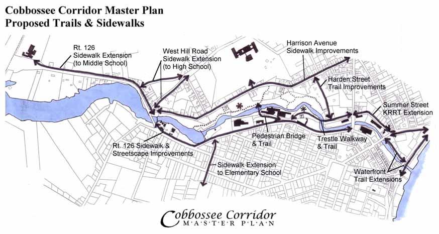
2 LAND USE PLAN While the land uses that have historically dominated the Corridor itself have been industrial/commercial, the Master Plan proposes a shift to mixed-use redevelopment, complimented by a network of open space and trails, that will enhance the quality of the Cobbossee Stream area and the downtown. (It should be noted that most sites have multiple options for redevelopment.) The housing and commercial redevelopment sites are described in further detail in Section II, Redevelopment Sites Description & Recommendations. See also the Proposed Land Use Diagram at the end of the Land Use Plan description. 7. Housing Housing is a critical to bringing people and activity back into the Corridor, and to supporting businesses in the Corridor and downtown. The Cobbossee Corridor is largely surrounded by residential neighborhoods, and serves as a physical link between these neighborhoods and the downtown. Also, to ensure the integration of uses in the Corridor and its surroundings, the development of housing within the Corridor is essential, as is good open space and pedestrian infrastructure. Cobbossee Stream and its associated open space and trails, as well as access to the KRRT and Gardiner Waterfront. Cultural and historic amenities along the Corridor, such as the proposed museum-on-the-stream, also provide for quality housing locations. Furthermore, the Corridor s location is convenient to downtown Gardiner, which means the availability of services, shopping and dining. The housing development sites shown in the plan (below), including the mixed-use development sites, are better suited to townhouse style housing than single-family detached. These sites have the potential for intermediate range (not high-end) housing or market-rate rental housing, as well as affordable and elderly housing. Two key sites are shown in the Master Plan as housing development opportunities, while several other sites within the Corridor are shown as mixed-use (both housing and The Cobbossee Corridor has high amenity value for housing development, which is attractive to developers and buyers or renters. The Corridor s scenic, natural, and recreational value arises from the 22
 and a single-family residential lot; this site could be developed with or")

3 office/retail). The two key sites are on Harrison Avenue near Ash Street (the Usdan property), and on Summer Street next to Harden Street. The Usdan housing site on Harrison Avenue includes two parcels, one which the City is slated to purchase (the Usdan property) and a single-family residential lot; this site could be developed with or without incorporating the single-family residential lot. The Summer Street housing site incorporates several smaller parcels, including the lot currently owned by the Maine Office of Tourism and part of the lot owned by the adjacent church. Other sites identified as mixed-use development opportunities (both housing and office/retail) include the Warren site (Kennebec Brewing Co. site), the Gardiner Paperboard site, and D&H Motors. These each offer the potential for apartments, condominium or studio type housing. 8. Commercial As noted in the "Cobbossee Corridor in Context", the Cobbossee Corridor holds the potential to become one of Gardiner's major economic generators (along with the downtown, Libby Hill, and Route 201 corridor). Many of the sites within the Corridor have excellent potential for highquality, commercial or mixed-use redevelopment. The Corridor also lies within an existing TIF district, which provides further redevelopment benefits for investors. The redevelopment sites identified in the plan are ideal locations for commercial and mixed uses. They feature easy access to the Interstate, adjacency to the downtown, availability of local and area services, good infrastructure and utilities, and the amenity value of the scenic Cobbossee Stream and its associated natural and recreational features. Such features draw developers and businesses, as well as potential customers/clients to support economic development. The Corridor also holds the potential to fill an economic niche that downtown and Libby Hill cannot, attracting the "cultural creatives" (creative entrepreneurs) and possibly small research and development facilities (see Section III, Economic Development Analysis). Cobbossee Corridor is also ideal for high-quality offices, retail and mixed-use (generally class A or B office space, buildings 10,000 sq. ft. or smaller). 9. Open Space The open space and recreational opportunities along Cobbossee Stream not only enhance quality of life but promotes economic development in the Corridor and the downtown. The recreational opportunities along the Cobbossee Stream Corridor offers the potential to boost 23


4 regional tourism, which would support economic growth in the downtown area. For example, Gardiner is on the Chaudiere/Kennebec Trail, and the KRRT will eventually become part of a spur connecting to the East Coast Greenway in Brunswick. Boat trips on the Kennebec could also link with the trail system, by way of docks at the waterfront park. The City-owned Jannace property, on the northwestern side of Cobbossee Stream, is the largest piece of open space. (See Jannace open space plan, next page.) This site has some of the most dramatic topography and views in the Corridor. The proposed trails & picnic area on the Jannace and adjacent Usdan property link to the Harrison Avenue neighborhood and the High School already, and the proposed pedestrian bridge (next to Gardiner Paperboard) connects to businesses and residences on the other side of Cobbossee Stream, and to the downtown. Parking and access from Harrison Avenue is provided in three places: on the Jannace property by the access trail to the High School; on the Usdan property just southwest of Jannace (off the existing access road); and at the end of Harrison Avenue by the New Mills bridge (existing Water District property). The trail leading through the Usdan property could be connected along the roadway to future trailhead parking at the current Water District yard next to the New Mills bridge. There are two sites that the City should consider purchasing from the Water District, if they become available: one being the stream-side lots at the Route 126/9 end of Harrison Ave, and the other being the stream-side lot on the other side of the New Mills bridge and Route 126/9 from the Water District site (see diagrams, right). Map 28 Lot 80 Map 28 Lots 4 & 6 Potential Open Space: Water District Property at New Mills Land Use Diagram Highlighting Potential Open Space GWD lots 24


5 JANNACE PROPERTY OPEN SPACE PLAN Woods Trails Picnic & Passive Recreation Proposed Pedestrian Bridge Water District property at New Mills Jannace property, between the Stream and Harrison Ave. 25


6 PROPOSED LAND USE DIAGRAM Commercial Mixed-Use Residential Utilities/Other Open Space For larger image, see end of Section I. 26

7 COBBOSSEE CORRIDOR REDEVELOPMENT PLAN For larger image, see end of Section I. 27
8 RECOMMENDED NEXT STEPS SUMMARY OF ACTIONS Corridor-Wide Actions 1) Publicize and promote the Plan. 2) Revise the City's ordinances, including the Resource Protection Zone, to be consistent with the Plan. 3) Begin the planning and implementation of the trail and open space (park) system. 4) Establish an open-air museum trail through the Corridor. 5) Offer marketing, permitting, loan, financing, tax credit, and infrastructure assistance to cooperating landowners in the Corridor. 6) Help negotiate access agreements, easements and/or land trades that benefit adjoining owners. 7) Explore ways to market the corridor as a green, environmentally friendly place. CORRIDOR-WIDE ACTIONS 1. Publicize and promote the Plan Seek unanimous endorsement of the Plan from the Council. Provide each landowner with an informational package about their property that includes maps, photos, and parcel data sheets (see Appendix). Meet one-on-one with landowners to review the Plan and the ideas for their properties. Prepare a marketing folder or brochure with plans, photos, and sketches that help market the corridor. Promote the assets of the Corridor through the press and trade and economic development groups. 2. Revise the City's ordinances, including the Resource Protection Zone, to be consistent with the Plan Specific Actions 8) Acquire the Usdan property and advertise for a developer(s) to work with the City to develop offices and/or housing on the Usdan properties (east and west of the Stream). 9) Negotiate an agreement with Everett J. Prescott, Inc., and the Gardiner Water District under which they both benefit (i.e. Everett J. Prescott, Inc., gains parking and Gardiner Water District gains additional future expansion space) 10) Offer to help the owner of the T.W. Dick property develop a quality, high-profile project (or projects) to jump-start redevelopment. Request that the shoreland resource protection district mapping be revised for the area around New Mills and the south end of Harrison Avenue; this area is incorrectly mapped now; the rationale for making it resource protection is not evident. The area is part existing residences and part woods; steep slopes and wetlands (or other important resources needing protection) are not present (see suggested map revision). The current downtown business zone covering the corridor is appropriate; it provides for a mix of land uses and gives owners/developers choices and 28
9 flexibility that should encourage investment. All residential proposals would be treated as planned residential projects and subject to site plan review. The City should encourage owners and/or developers to use the contract zoning provisions within Gardiner s ordinance. They provide more opportunity to be creative while giving the planning board more flexibility in interpreting the regulations and in contracting agreements from which both parties stand to gain. 3. Begin the planning and implementation of the trail and open space (park) system Submit a trails grant application, under MDOT s Enhancement Program, matched with City funds comprising at least 20% of the total (see Appendix). Continue to upgrade sidewalks throughout the Corridor area using CIP set-aside funds for trails and sidewalks. Seek out other public (and private) funds to build trails and create open space and parks. Obtain easements from property owners, where appropriate, to ensure the continuity of trail systems (e.g., T.W. Dick site; CMP; Standard Distributors) (see #6). Work with the Kennebec Land Trust to make improvements to the Jannace property, including offstreet parking, picnic places, and nature trails. Work with the schools to make direct connections between each school and the main stem of the Cobbossee trail system. Develop a park, trailhead parking and a trestle landscape plan for the MDOT land along the Stream at the Kennebec Brewery area (see #6). Consider acquisition of the single-family residence next to the substation, on Harrison Avenue; it is adjacent to the City-owned Jannace property. 4. Establish an open-air museum trail through the corridor. The 19 th Century history of waterpower and manufacturing along Cobbossee Stream is unlike any in Maine. The Stream, with its 130-foot elevational drop, from Pleasant Pond to the Kennebec River, was the Silicon Valley of the State in the 1800s. With up to 10 dams and innumerable businesses harnessing the Stream s power, the Corridor was unique. Today, many of the remnants of Cobbossee Stream s heyday are still evident and its rich history is well documented. This provides an opportunity for the City to feature this history of jobs, early paper manufacturing, and much more, in exhibits and educational displays along the proposed trail system. Over time the City should: Urge the Gardiner residents to become active researchers and promoters of a Cobbossee outdoor history trail an outdoor museum on the Stream. 29
10 Seek support for such a museum from the State museum, the Chaudière-Kennebec Corridor group, and from the Paper Industry Information Office. Encourage local schools to incorporate aspects of the Corridor s history in their curriculum s and visit the trail as an outdoor, community classroom. Seek grants and private donations to pay for trailside signs and interpretive/educational displays. Make the trail an extension of downtown and Main Street Gardiner. available to those who choose to follow the Plan goals and work cooperatively with the City to upgrade or build new, quality, facilities. In particular, promote the benefits of TIF and New Markets Tax Credit Programs. Assist businesses with their project/development plans (provided they follow the Plan s goals) with financing and permitting assistance. Also refer to the following list of funding sources. 5. Offer marketing, permitting, loan, financing, tax credit, and infrastructure assistance to cooperating landowners in the corridor. If the City makes a commitment to improving the Stream Corridor for residents and businesses alike by applying for grants and setting aside funds for improvements, it should encourage and reward quality development that generates tax revenue. Just as the City has laid the groundwork for success at Libby Hill, so should the City favor quality, good, taxgenerating development that can be Tax Increment Financed especially if the TIF monies contribute to the betterment of the entire Corridor (see box titled: Market Quality ). 6. Help negotiate access agreements, easements and/or land trades that benefit adjoining owners In order for the corridor to function effectively and efficiently, traffic must be able to operate safely and pedestrians and cyclists must be able to move about on legal rights-of-way. However, given the steep topography of the Corridor and the pattern of ownership, cooperation is essential. Note: Some legal and/or survey work may be warranted to establish property lines, old rights-of-way, and access easements on various parcels. Tax map information is incomplete. The City should: The City s Economic Development office should: Make existing and potential businesses/developers aware of the array of economic development tools Work with MDOT to either acquire or lease the abandoned railroad right-of-way, from the Kennebec River Rail Trail to Standard Distributors, including floodplain ownership adjacent to the rail trestle. 30
COBBOSSEE CORRIDOR MASTER PLAN. For larger image, see end of Section I.
 COBBOSSEE CORRIDOR MASTER PLAN For larger image, see end of Section I. 11 REDEVELOPMENT PARCELS For larger image, see end of Section I. 12 COBBOSSEE CORRIDOR S RICH HISTORY ACOBBOSSEE CORRIDOR HISTORICAL
Mendota Heights 2040 Comprehensive Plan Draft Vers
 4 Parks and Trails The City of Mendota Heights boasts a variety of recreational and open space opportunities. Few cities can claim access to regional trails, riverside and lakeside parks, scenic bluffs
Planning Districts INTRODUCTION
 INTRODUCTION To facilitate detailed examination of development prospects for all areas of the community, Delano has been divided into 14 planning districts. The location of these planning districts is
Wisconsin downtown action council Downtown project case study profile
 Wisconsin downtown action council Downtown project case study profile Project Name Onalaska Waterfront Project Location City of Onalaska Project Type (check all that apply) g Residential g Commercial g
1. Parks & Recreation Neighborhood Parks Community Parks Special Use Sites 2. Open Space 3. Trails
 Appendix A: Park Classifications The intent of parks and recreation classifications is to aid in making acquisition and design decisions for park sites, facilities and the organization of recreation space
The City shall enhance and improve the accessibility of parks and recreational facilities while protecting their quality. by:
 GOALS, OBJECTIVES AND POLICIES GOAL 1: To provide open space and recreation as an essential element needed for the betterment of the City s character and quality of urban life. The City shall plan for
The following principles guide the development of goals and strategies to protect and promote these amenities:
 OPEN SPACE/PARKS/TRAILS/RECREATION GOALS/STRATEGIES Cherry Hills Village is a living environment that offers low density development, open areas, public scenic vistas, public trails and public parks. This
Below the trestle lie artifacts of past industry along the Cobbossee Stream. South end of the trestle, at the proposed trailhead area.
 The existing railroad trestle, when refitted as a pedestrian walkway, could be an important, eye-catching, scenic component to the Cobbossee Stream Trail. South end of the trestle, at the proposed trailhead
Downtown Dubuque...it s a great time.
 Downtown Dubuque...it s a great time. Your timing could not be better to invest in Downtown. With hundreds of millions in public and private investment occurring on the City s downtown waterfront, millions
Whitemarsh Township Greenway Plan
 Whitemarsh Township Greenway Plan Prepared for: Whitemarsh Township August 16, 2007 Table of Contents Table of Contents... i Introduction... 1 Study Area Setting... 2 Regional Setting... 2 Township Character...
METROPOLITAN COUNCIL 390 North Robert Street, St. Paul, MN Phone (651) ; TDD (651)
 ; TDD (651)") DATE: December 20, 2011 METROPOLITAN COUNCIL 390 North Robert Street, St. Paul, MN 55101 Phone (651) 602-1000; TDD (651) 291-0904 TO: Metropolitan Parks and Open Space Commission FROM: Tori Dupre, Senior
DATE: December 20, 2011 METROPOLITAN COUNCIL 390 North Robert Street, St. Paul, MN 55101 Phone (651) 602-1000; TDD (651) 291-0904 TO: Metropolitan Parks and Open Space Commission FROM: Tori Dupre, Senior
{Best Practices. Summary of Tools, Strategies and Best Practices from 11 Michigan Case Study Communities
 Case Studies Michigan Coastal Community Working Waterfronts { Summary of Tools, Strategies and from 11 Michigan Case Study Communities Table of Contents Zoning...2 Community and Stakeholder Collaboration
We are a determined group residents, industry, and government and by working together an incredible future lies ahead for Troy.
 PROPOSED EDITS TO COMPREHENSIVE PLAN April 5, 2018 Page Par Change Iv TOC Principle 2, page number is 3 should be 33 I Forward Par 3, delete Strike through: Troy is today experiencing 3 1.1 Par 3 change
Midtown Greenway Land Use and Development Plan Executive Summary
 Midtown Greenway Land Use and Development Plan Executive Summary Introduction The Midtown Greenway Land Use and Development Plan sets policy direction for land use and development in the Midtown Greenway
The transportation system in a community is an
 7 TRANSPORTATION The transportation system in a community is an important factor contributing to the quality of life of the residents. Without a sound transportation system to bring both goods and patrons
Yadkin River Greenway Feasibility Study Fact Sheet Village of Clemmons, Town of Lewisville, Town of Bermuda Run
 Fact Sheet Village of Clemmons, Town of Lewisville, Town of Bermuda Run Project Background The Yadkin River Greenway Feasibility Study is a joint project with the Village of Clemmons, the Town of Bermuda
PART 1: PROJECT SUMMARY. The application is Attachment A. The site plan is Attachment B.
 Belleterre Subdivision Sketch Plan Town Board 8.7.17 Belleterre Subdivision Sketch Plan PART 1: PROJECT SUMMARY Applicant: Bowman Development Project Size: +/- 20.85 acres Parcel Number: 01115104 and 01115121
Atlanta BeltLine Subarea 3 Master Plan Update
 Atlanta BeltLine Subarea 3 Master Plan Update April 14, 2018 Workshop Meeting 1 22 miles, connecting 45 neighborhoods 22 MILES of transit 46 MILES of streetscapes and complete streets 33 MILES of urban
DISCUSSION TOPIC: ST JOHNS RIVER & ITS TRIBUTARIES (BPII) 2030 COMPREHENSIVE PLAN POLICES AND REGULATORY FRAMEWORK
 2030 COMPREHENSIVE PLAN POLICES AND REGULATORY FRAMEWORK") DISCUSSION TOPIC: ST JOHNS RIVER & ITS TRIBUTARIES (BPII) 2030 COMPREHENSIVE PLAN POLICES AND REGULATORY FRAMEWORK St. John s River & Its Tributaries Issue Summary: The St. Johns River is an important
DISCUSSION TOPIC: ST JOHNS RIVER & ITS TRIBUTARIES (BPII) 2030 COMPREHENSIVE PLAN POLICES AND REGULATORY FRAMEWORK St. John s River & Its Tributaries Issue Summary: The St. Johns River is an important
Support the implementation of Cape Coral's Comprehensive Plan. Protect and utilize the unique natural resources in the City.
 7.0 OVERVIEW - RECOMMENDATIONS Chapter 7 The preparation of the Cape Coral Parks and Recreation Master Plan spanned a period of approximately 12 months. Plan preparation included the input of a wide range
Port Lavaca Future Land Use
 Port Lavaca Future Land Use Introduction The City of Port Lavaca is beginning to see sustained growth, after many years of relative stable population. New single family homes, apartments, and businesses
SECTION II SECTION II STATEMENT OF GOALS, OBJECTIVES, PRINCIPLES, ASSUMPTIONS, POLICIES AND STANDARDS
 STATEMENT OF GOALS, OBJECTIVES, PRINCIPLES, ASSUMPTIONS, POLICIES AND STANDARDS 1 2 STATEMENT OF GOALS, OBJECTIVES, PRINCIPLES, ASSUMPTIONS, POLICIES AND STANDARDS INTRODUCTION The New Jersey Municipal
Draft Stillwater 2030 Comprehensive Plan- Goals and Policies
 Draft Stillwater 2030 Comprehensive Plan- Goals and Policies Instructions- Review each goal and policy and discuss with group any changes, deletions for additions to the list using your groups pen. Keep
Best Practices Appendix: Waterfront Communities
 Redevelopment Ready Communities Best Practices Appendix: Waterfront Communities revised September 2014 Waterfront RRC defined The purpose of these additional criteria is to provide waterfront communities
CHAPTER 8 ISSUES, CONCERNS, CONSTRAINTS AND OPPORTUNITIES
 CHAPTER 8 ISSUES, CONCERNS, CONSTRAINTS AND OPPORTUNITIES Introduction This River Conservation Plan was developed during a time of tremendous activity and effort in planning the transformation of the Delaware
Green Infrastructure The Indianapolis Greenways Connection
 Green Infrastructure The Indianapolis Greenways Connection Fewer things in the transportation industry today make better since than combining the needs for pedestrian and bike trails with the need to locate,
Town of Brookfield Master Plan Implementation Matrix Action
 1 Econ Dev 1 Establish Economic Development Commitee Econ Dev 2 Develop streamlined permitting process Econ Dev 3 Increase economic development in town center Econ Dev 4 Revise town bylaws/zoning for commercial/industrial
V. Vision and Guiding Principles
 V. Vision and Guiding Principles The Master Plan for the Powers Ferry Corridor seeks a foundation in the desires of the community. At times, various elements of the community offered opposing viewpoints,
Promoting Economic Development Through Upfront SEPA Review: Lessons from South Downtown Tacoma
 Promoting Economic Development Through Upfront SEPA Review: Lessons from South Downtown Tacoma 1 This session will focus on the City of Tacoma s South Downtown Subarea Plan and associated Non-Project SEPA
Comprehensive Plan. Faribault, Minnesota. Hoisington Koegler Group Inc. Claybaugh Preservation Architecture Inc. Howard R. Green Company Bonz/REA
 Comprehensive Plan Faribault, Minnesota Adopted by the Faribault City Council July 8, 2003 prepared for: prepared by: Hoisington Koegler Group Inc. Claybaugh Preservation Architecture Inc. Howard R. Green
Albert Lea. Redevelopment Plan. 701 Xenia Avenue South, Suite 300 Minneapolis, MN Tel: (763) Fax: (763) wsbeng.
 Fax: (763) wsbeng.") Albert Lea Redevelopment Plan 701 Xenia Avenue South, Suite 300 Minneapolis, MN 55416 Tel: (763) 541-4800 Fax: (763) 541-1700 wsbeng.com Albert Lea Redevelopment Plan Table of Contents Composite Districts...
Albert Lea Redevelopment Plan 701 Xenia Avenue South, Suite 300 Minneapolis, MN 55416 Tel: (763) 541-4800 Fax: (763) 541-1700 wsbeng.com Albert Lea Redevelopment Plan Table of Contents Composite Districts...
TABLE OF CONTENTS. Transportation Chapter 1 - Introduction and Purpose of Planning to 1-3. Utilities
 Chapter 1 - Introduction and Purpose of Planning... 1-1 to 1-3 Pennsylvania Municipalities Planning Code (Act 247)...1-1 Previous County Planning Activities...1-1 Objectives of the Plan...1-2 Elements
Mendota-Lebanon Hills Greenway Master Plan Executive Summary. August draft for more information visit
 Mendota-Lebanon Hills Greenway Master Plan Executive Summary August 2013 draft for more information visit www.hkgi.com/projects/dakota INTRODUCTION The Mendota-Lebanon Hills Greenway Master Plan portrays
Ship Creek Redevelopment
 Ship Creek Redevelopment Three Concepts May 2013 Cambridge ARCHITECTURE Philadelphia ENGINEERING Raleigh INTERIORS San Francisco PLANNING Washington, DC www.klingstubbins.com contact@klingstubbins.com
City of Meriden Harbor Brook Flood Control Project Overview
 City of Meriden Harbor Brook Flood Control Project Overview Updated August 2013 OVERVIEW The center of Meriden, including the HUB site is the low point of the town which is ringed by basalt ridges. Running
WILLAMETTE FALLS LEGACY PROJECT
 OPPORTUNITIES & CONSTRAINTS There are here three falls on a line of rocks extending across the river, which forms the bed of the upper channel. The water is precipitated through deep abrazed gorges, and
Madison St. Oak Park. Request for Proposals. Village Owned Parcel Madison Street Oak Park, Illinois Reissued May 25, 2018.
 Madison St. Oak Park Village Owned Parcel 700-728 Madison Street Oak Park, Illinois Reissued May 25, 2018 Proposal Due, 2018 Date 3:00 pm 700-728 Madison Street including adjacent public alley and street
BROOKHILL NEIGHBORHOOD MODEL ZONING MAP AMENDMENT PREFACE TO APPLICATION
 BROOKHILL NEIGHBORHOOD MODEL ZONING MAP AMENDMENT PREFACE TO APPLICATION June 15, 2015 Revised: August 1, 2016 I. VISION Brookhill is a proposed community based upon the principles of Albemarle County
RECREATION AND OPEN SPACE ELEMENT GOALS, OBJECTIVES, AND POLICIES
 RECREATION AND OPEN SPACE ELEMENT GOALS, OBJECTIVES, AND POLICIES Goal 7 To provide park facilities, recreation programs, and open space resources that are safe, adequate, and accessible to all City residents,
STAFF RECOMMENDATION: Adopt the Parks and Recreation Master Plan 2013, or take other action as deemed appropriate.
 Regular 7. CITY COUNCIL AGENDA Meeting Date: 12/02/2013 TITLE: Parks and Recreation Master Plan 2013 Adoption Proposal - Dwight Curtis Responsible Staff: Dwight Curtis Backup Material: Backup material
EXHIBIT A. Tax Increment Reinvestment Zone No. 1 (Town Center) First Amended Project Plan 1
 First Amended Project Plan 1") EXHIBIT A Tax Increment Reinvestment Zone No. 1 (Town Center) First Amended Project Plan 1 1 As amended by Resolution No. 2008-02-001(TR1R) of the Tax Increment Reinvestment Zone No.1, and approved to
EXHIBIT A Tax Increment Reinvestment Zone No. 1 (Town Center) First Amended Project Plan 1 1 As amended by Resolution No. 2008-02-001(TR1R) of the Tax Increment Reinvestment Zone No.1, and approved to
This page intentionally blank.
 This page intentionally blank. Parks, Recreation, and Open Space Chapter Relationship to Vision Vision Parks, Recreation and Open Space Chapter Concepts County Government. County government that is accountable
PLAN ELEMENTS WORKSHOP. April 5, 2016
 PLAN ELEMENTS WORKSHOP April 5, 2016 needs more housing. But there is no one-size fits-all solution. Every neighborhood has its own character. In some places, density is not only appropriate it is badly
Small Area Plan. South Gateway
 Small Area Plan Adopted May 12, 2008 South Gateway Purpose. The South Gateway Small Area Plan defines the City s expectations for the future of the southern entrance to the City at Interstate 85 and Highway
CHAPTER 7: Transportation, Mobility and Circulation
 AGLE AREA COMMUNITY Plan CHAPTER 7 CHAPTER 7: Transportation, Mobility and Circulation Transportation, Mobility and Circulation The purpose of the Transportation, Mobility and Circulation Chapter is to
Waterfront West December 6, 2016
 1 Waterfront West December 6, 2016 Agenda 1. Development Team 2. Waterfront History As Our Guide. A Compelling Site Idea 4. Community Benefits 5. Zoning 6. Architectural Context 7. Project Renderings 8.
DRAFT ROOSEVELT ROAD. District Recommendations. Figure 5.23 The Roosevelt Road Corridor
 CHAPTER 5 Figure 5.23 The Road Corridor Road will develop as a mixed-use corridor, emphasizing regional retail, west of the river and mixed-use development east of the river. KEY RECOMMENDATIONS 1. High
CHAPTER 7. Capital Improvement Strategies
 Capital Improvement Strategies Capital Improvement Strategies Public capital investment in improvement projects, namely streetscape improvements, the creation of gateways, the continued extension of the
Exhibit A. 8:9 Scuffletown Rural Conservation District
 Exhibit A 8:9 Scuffletown Rural Conservation District 8:9.1 Intent and Purpose The Scuffletown Rural Conservation (SRC) District is intended to provide for residential development that supports the development
Town Center (part of the Comprehensive Plan)
") Town Center (part of the Comprehensive Plan) Mercer Island Town Center Looking North (2014) In 1994, a year-long process culminated in a set of design guidelines and code requirements for the Town Center
Town Center (part of the Comprehensive Plan) Mercer Island Town Center Looking North (2014) In 1994, a year-long process culminated in a set of design guidelines and code requirements for the Town Center
PLANNING RATIONALE FOR 1127, 1128 MILL STREET AND 1125 CLAPP LANE CITY OF OTTAWA
 PLANNING RATIONALE FOR 1127, 1128 MILL STREET AND 1125 CLAPP LANE CITY OF OTTAWA Prepared by: Realty Initiatives and Development On behalf of the Manotick Mill Community Lands Development Corporation March
Parks, Recreation, and Open Space Land Use Goals
 Parks, Recreation, and Open Space Land Use Goals Issue: The preservation of open space and natural features will enhance the character of the built environment, promote public health and safety, provide
Chapter 3. Community Vision and Goals
 Chapter 3. Community Vision and Goals 3.1 Public Involvement Charlevoix s master plan was prepared in a way that maximized public participation. Dating back to 2004, the Planning Commission and staff held
Appendix C Implementation Schedule
 Implementation Schedule Regional, Historical and Environmental Setting Seek recollection of 20th Century Shipyard products for historical preservation and community display. Implement recommendations from
Commercial Node Plan Devine Street/Jackson Blvd. COLUMBIA, SC
 Commercial Node Plan Devine Street/Jackson Blvd. COLUMBIA, SC 9.17.13 AGENDA 1 Introductions 2 Project Update 3 Concepts 4 Recommendations 5 Next Steps Introductions Project Update Process 5-Phase Process
Town of Peru Comprehensive Plan Executive Summary
 Town of Peru Comprehensive Plan Executive Communities that plan grow by choice, not by chance. A plan makes growth thoughtful, understandable, and predictable. A plan shows that a community is managing
2018 Northampton Township Comprehensive Plan
 2018 BUCKS COUNTY, PENNSYLVANIA What is a? A comprehensive plan is a municipality s main policy document that details the collective vision for the future, the historic, environmental, and cultural facilities
REGIONAL ACTIVITY CENTER
 DRAFT REGIONAL ACTIVITY CENTER 70 EAST BENCH MASTER PLAN DRAFT 06 Introduction The East Bench Regional Activity center is comprised of large educational, research, medical, and employment centers. These
STUDY AREA. Tonight s Agenda. Project Tasks Completed. Next Steps. Town of Oyster Bay Eastern Waterfront Community Vision & Revitalization Plan
 Town of Oyster Bay Eastern Waterfront Community Vision & Revitalization Plan Public Meeting January 27, 2009 Opening Remarks Presentation Tonight s Agenda Introduction Study Area Overview Public Participation
Southeast Quadrant Plan
 Southeast Quadrant Plan Southeast Quadrant Distinctive Features Land Use The Southeast Quadrant includes all the area within the planning area that is east of Interstate 5 and south of State Route 44.
Pittsfield Action Plan (West Branch of the Housatonic River)
") An initiative of the Massachusetts Executive Office of Energy and Environmental Affairs in partnership with the City of Pittsfield Pittsfield Action Plan (West Branch of the Housatonic River) The spring
An initiative of the Massachusetts Executive Office of Energy and Environmental Affairs in partnership with the City of Pittsfield Pittsfield Action Plan (West Branch of the Housatonic River) The spring
2.0 AREA PLANS. Lakeside Business District. Lakeside Business District Land Use Categories:
 Lakeside Business District Lakeside Business District Land Use Categories: Campus Commercial Campus Commercial means a mixture of uses which includes corporate offices, office parks, hotels, commercial,
3. VISION AND GOALS. Vision Statement. Goals, Objectives and Policies
 Vision Statement Queen Creek s interconnected network of parks, trails, open spaces and recreation opportunities provide safe and diverse activities and programs that sustain its unique, small town, equestrian
Gold Line Bus Rapid Transit Transit Oriented Development (BRTOD) Helmo Station Area Plan
 Helmo Station Area Plan") Appendix F Gold Line Bus Rapid Transit Transit Oriented Development (BRTOD) Helmo Station Area Plan Introduction and Purpose of the Plan The Gold Line Bus Rapid Transit facility is an eleven-mile dedicated
Appendix F Gold Line Bus Rapid Transit Transit Oriented Development (BRTOD) Helmo Station Area Plan Introduction and Purpose of the Plan The Gold Line Bus Rapid Transit facility is an eleven-mile dedicated
Planning Board Briefing
 Planning Board Briefing Why Now? The Sector Plan Implementation Chapter States: Before Stage 1 begins, the following must occur: Approval of the Sectional Map Amendment. Approval of the Greater Lyttonsville
Drexel, Barrell & Co.
 Drexel, Barrell & Co. June 18, 2018 Engineers/Surveyors Boulder Colorado Springs Greeley 3 South 7 th Street Colorado Springs, Colorado 80905-1501 719 260-0887 719 260-8352 Fax El Paso County Planning
Civic Center District
 Civic Center District The Civic Center district is the civic and social heart of Warrenville, containing such public buildings as the City Hall, Warrenville Public Library, Police Station, Park District
Comprehensive Plan ADOPTED APRIL 2014
 Comprehensive Plan ADOPTED APRIL 2014 8 8. Outstanding Recreational & Cultural Opportunities We are proud of our community s parks and recreation system. Our community will ensure that the legacy of our
ESTABLISH AN EFFICIENT TOWN CENTER
 ESTABLISH AN EFFICIENT TOWN CENTER 4 Overview Lisbon residents are proud of the history of Newent and at the same time recognize its current importance as a centralized location for a variety of municipal
Preface. Erie. Scranton. Allentown. Pittsburgh. Harrisburg. Philadelphia
 The Southern Alleghenies Region The Southern Alleghenies Region spans the Laurel Highlands and Allegheny Front in the west across the Appalachians to the east. It is comprised of Blair, Bedford, Cambria,
Hibbing. Land Use. Hibbing Comprehensive Plan 8.1. Land Use
 Hibbing 8.1 Introduction 8.3 Information and Assessment 8.5-8.14 Recommendations 8.15-8.17 Implementation 8.18-8.19 8.2 Introduction Although land use was not identified as a discrete goal during the community
LPC Goals and Strategies. Transportation and Connectivity Employment Opportunities Food Access Waterfront Access Livable Communities
 LPC Goals and Transportation and Connectivity Employment Opportunities Food Access Waterfront Access Livable Communities Transportation and Connectivity Goal: Safe and ready access of all types allowing
VILLAGER SQUARE URBAN RENEWAL PLAN
 VILLAGER SQUARE URBAN RENEWAL PLAN City of Broomfield August 21, 1997 1 Table of Contents Villager Square Urban Renewal Project Urban Renewal Plan A. PREFACE 1 B, URBAN RENEWAL AREA BOUNDARIES 1 C. SUMMARY
Drexel, Barrell & Co.
 Drexel, Barrell & Co. December 21, 2018 Engineers/Surveyors Boulder Colorado Springs Greeley 3 South 7 th Street Colorado Springs, Colorado 80905-1501 719 260-0887 719 260-8352 Fax El Paso County Planning
hermitage town center
 hermitage town center A Community Vision prepared by Strada for The City of Hermitage and The Mercer County Regional Planning Commission January 2007 table of contents introduction 3 design principles
Preliminary Plan Framework: Vision and Goals
 Preliminary Plan Framework: Vision and Goals Draft: May 2015 Introduction Since the Town of Milliken s comprehensive plan was last updated in 2010, the community was heavily impacted by the 2013 flood,
Parks, Open Space and Trails
 Introduction Parks have often been referred as the lungs of our cities, cleansing the air of pollutants and particulate matter. Parks are also gathering places for families and community. They offer spaces
Bourne Downtown Site Planning
 Prepared for: The Town of Bourne, MA In Cooperation with: Bourne Financial Development Corporation Prepared by:, Inc. June 24, 2009 Table of Contents Introduction and Summary... 1 Site Existing Conditions...
Welcome to the Oakridge Centre Open House
 Welcome to the Oakridge Centre Open House Why is the City hosting this event? This open house is to inform you of a rezoning application submitted to the City of Vancouver to amend the existing CD-1 (Comprehensive
Potential Green Infrastructure Strategies May 6, 2015 Workshop
 Potential Green Infrastructure Strategies May 6, 2015 Workshop Background The City of Cortland is developing the Tioughnioga Urban Headwaters Green Infrastructure Action Plan with funding from the National
RECREATION, OPEN SPACE AND GREENWAYS ELEMENT GOALS, OBJECTIVES, AND POLICIES
 RECREATION, OPEN SPACE AND GREENWAYS ELEMENT GOALS, OBJECTIVES, AND POLICIES GOAL R-1: DEVELOP A RECREATION, OPEN SPACE AND GREENWAYS SYSTEM AS AN INTEGRAL COMPONENT OF AN OVERALL, COUNTY-WIDE ECONOMIC
PARTF Scoring System for Grants
 PARTF Scoring System for Grants The members of the N.C. Parks and Recreation Authority use the PARTF scoring system as one of several tools to select grant recipients. Please provide all of the information
Windsor, Connecticut Plan of Conservation & Development DRAFT PLAN SUMMARY
 Windsor, Connecticut 2015 Plan of Conservation & Development DRAFT PLAN SUMMARY Plan Overview What is a Plan? Visionary Advisory Implementable Maintainable What it is not! Regulatory Binding Static Passive
Proposed Walkability Ordinance for City of Knoxville (6/16/17)
") Proposed Walkability Ordinance for City of Knoxville (6/16/17) New or revised text is highlighted Section 1: Purpose The purpose of this ordinance is to set requirements for walkability and pedestrian
Proposed Walkability Ordinance for City of Knoxville (6/16/17) New or revised text is highlighted Section 1: Purpose The purpose of this ordinance is to set requirements for walkability and pedestrian
E. RURAL COMMERCIAL/INDUSTRIAL PARK MODEL
 E. RURAL COMMERCIAL/INDUSTRIAL PARK MODEL 1. PURPOSE The purpose of the Rural Commerce/Industrial Park Model is to provide parameters within which a grouping of business buildings with parking, loading
1.0 Circulation Element
 5/9/18 1.0 Circulation Element 1.1 Introduction As growth and development occur in Apache County, enhancements to its circulation system will be necessary. With time, more roads will be paved and air and
To qualify for federal Transportation Enhancement (TE) funds a project must meet two basic federal requirements:
 funds a project must meet two basic federal requirements:") Eligibility Requirements To qualify for federal Transportation Enhancement (TE) funds a project must meet two basic federal requirements: 1) Relate to surface transportation and 2) Be one of the 12 designated
Eligibility Requirements To qualify for federal Transportation Enhancement (TE) funds a project must meet two basic federal requirements: 1) Relate to surface transportation and 2) Be one of the 12 designated
Chapter 13: Implementation Plan
 Implementation A. Introduction The Implementation Plan, in table form on the following pages, provides a summary of all the Action Items recommended in Chapters 2 through 12. The table also indicates which
2030 Comprehensive Plan VISION STATEMENT
 RESOURCE DOCUMENT for Steering Committee Meeting #2 July 12, 2017 2030 Comprehensive Plan VISION STATEMENT Steering Committee from 2008 Established the Lauderdale s Vision as: Creating a livable, lovable
Metropolitan Parks and Open Space Commission
 Business Item No. 2013-xxx Metropolitan Parks and Open Space Commission Meeting date: October 1, 2013 For the Community Development Committee meeting of October 7, 2013 Subject: Mendota-Lebanon Hills Greenway
Realities and Assets in an In-Town Shopping Center
 SUSTAIN SOUTHERN MAINE MILL CREEK PILOT LESSONS LEARNED April 15, 2013 Realities and Assets in an In-Town Shopping Center 1. An older shopping district that was laid out in a low-density, strip center
Town of Rico Three Mile Plan for Annexation
 Town of Rico Three Mile Plan for Annexation 10.20.2010 Adopted by Resolution 2010-2 Produced with funding support from the Colorado Department of Local Affairs 2 Content Guide Introduction. 3 Annexation
Planning for Waterfront Communities
 Planning for Waterfront Communities Redevelopment Ready Communities Supplemental Training Program OFFICE OF THE GREAT LAKES Waterfront Community Best Practices and Guidelines New supplemental criteria
ROAD CLOSURE AND LAND USE AMENDMENT SILVER SPRINGS (WARD 1) NORTHEAST OF NOSEHILL DRIVE NW AND SILVER SPRINGS ROAD NW BYLAWS 2C2018 AND 29D2018
 NORTHEAST OF NOSEHILL DRIVE NW AND SILVER SPRINGS ROAD NW BYLAWS 2C2018 AND 29D2018") Page 1 of 19 EXECUTIVE SUMMARY This application proposes redesignating two parcels in the community of Silver Springs from Special Purpose Future Urban Development (S-FUD) District and undesignated road
Page 1 of 19 EXECUTIVE SUMMARY This application proposes redesignating two parcels in the community of Silver Springs from Special Purpose Future Urban Development (S-FUD) District and undesignated road
Olde Towne Vision Plan
 Olde Towne Vision Plan Introduction In 2016, the City of Bellevue will complete its move of City offices from Olde Towne Bellevue to its new municipal complex on Wall Street. The City intends to sell its
Preliminary Assessment of Transportation Issues Related to Proposed Casino at Gateway South
 Preliminary Assessment of Transportation Issues Related to Proposed Casino at Gateway South DRAFT - 9/16/09 This memorandum summarizes the perspective of the City of Baltimore, Department of Transportation
Windsor Locks Transit-Oriented Development Planning Grant Request. Project Background
 Windsor Locks Transit-Oriented Development Planning Grant Request Project Background Downtown Windsor Locks runs along Main Street in the vicinity of the intersection of Routes 159 and 140. The current
OPEN HOUSE. Future. Neighborhood. Thursday April 27, :30 8:30 PM Refreshments provided Discovery Center, 4444 Hadley Avenue North
 OPEN HOUSE Thursday April 27, 2017 6:30 8:30 PM Refreshments provided Discovery Center, 4444 Hadley Avenue North The City Council has ini ated a planning process to guide future development on 206 acres
New Partners for Smart Growth Conference February 5, 2010
 Dan Stroh, Planning Director City of Bellevue Planning and Community Development Bellevue, WA New Partners for Smart Growth Conference February 5, 2010 Summary of Project Long-range plan update for Bel-Red
Regional Context Statement
 Regional Context Statement REGIONAL CONTEXT STATEMENT 3. REGIONAL CONTEXT STATEMENT In 1995, the Provincial Government passed into law the Growth Strategies Act. The purpose of this provincial initiative