The Landscape Project. New Jersey Department of Environmental Protection Division of Fish and Wildlife Endangered and Nongame Species Program
|
|
|
- Owen Wilkins
- 5 years ago
- Views:
Transcription

1 The Landscape Project New Jersey Department of Environmental Protection Division of Fish and Wildlife Endangered and Nongame Species Program


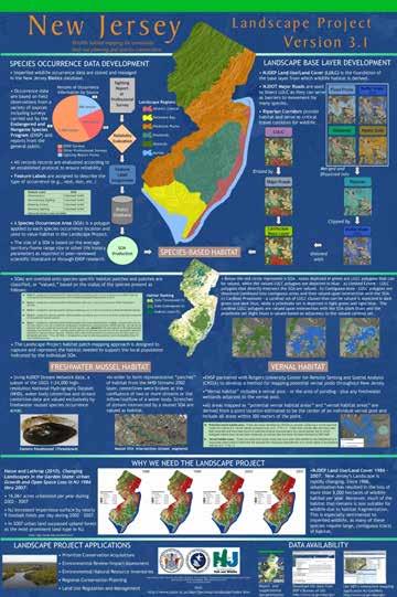
2 New Jersey is One of the smallest states in the country Yet it boasts a surprisingly wide diversity of habitat. It is the northern limit of many southern species, and the southern limit of many northern species.
3

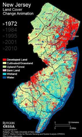
4 New Jersey s Changing Landscape Hasse and Lathrop (2010). Changing Landscapes in the Garden State: Urban Growth and Open Space Loss in NJ 1986 thru % increase in development rate to 16,061 acres per year by 2007 NJ increased impervious surface by nearly 9 football fields per day during Deforestation largely due to sprawling residential development. In 2007, urban developed land surpassed upland forest in total acres.


5 Changing Landscapes in the Garden State: Urban Growth and Open Space Loss in NJ 1986 thru 2007 John E. Hasse, Geospatial Research Lab, Rowan University Richard G. Lathrop, Center for Remote Sensing and Spatial Analysis, Rutgers University


6 Many Animals Move Across Large Areas Miles Miles Bobcat movements derived from GPS collar data (March December 04)


7 Development Reduces Habitat Connectivity Increases barriers to movement Decreases population viability Bog turtles rely on early successional, interconnected wetlands. If connectivity between populations is not maintained and the habitat surrounding the wetland protected, subpopulations of turtles are vulnerable to extirpation


8 Development Increases Mortality by increasing human-wildlife conflicts and road mortality
9 What is the Landscape Project? Landscape Project Maps: -- a set of GIS layers that depict habitat for endangered, threatened and special concern wildlife species based on documented occurrences from the Biotics database Biotics is the Department s database for tracking rare species occurrences. Expert biologists review all species sighting reports according to a specific protocol for acceptability/reliability and subsequently accept or reject species records combine species location information with NJDEP land-use/land-cover data provides users with science-based, peer-reviewed maps of species habitat areas in the state supply data without compromising sensitive species locations
10 Landscape Project Maps Habitat Patch Ranking: 1) Suitable Habitat - Meets suitability requirement defined for each habitat type. No documented occurrences. 2) State Special Concern At least one documented occurrence of a state special concern species. 3) State Threatened - At least one occurrence of a state threatened species. 4) State Endangered - At least one documented occurrence of a state endangered species. 5) Federally Listed - At least one documented occurrence of a federally listed.

11 Landscape Regions
12 Version 3.1 Species-Based Habitat Freshwater Mussel Habitat Vernal Habitat


13 Creating the Landscape Project Maps: LULC SPECIES DATA DEVELOPMENT Sighting Report or Professional Survey HABITAT DATA DEVELOPMENT Erased by Reliability Evaluation Major Roads Flood Prone Hydric Soils Feature Label Assignment Wetlands Water Buffer (50m) Riparian Water Buffer (100m) Landscape Base Layer Species-Based Habitat Biotics Database Clipped by Combined with SOA Production

14 Biotics Database Biotics Data The ONLY statewide database of all rare animal species in NJ. Same database used throughout the NatureServe network, which extends across all 50 states, Canada, Latin America and the Caribbean, for tracking imperiled and rare species occurrences.

15 Overview of data in Biotics Sources of Data (5yr average all data) Percent of Occurrence Information 450 recs/yr 1,450 recs/yr 600 recs/yr
16 Protocol for Accepting or Rejecting Species Sighting Reports Did the sighting occur within the known range of the species? Did the sighting occur in the known/recognized habitat for the species? Is the species easily identified, or is it often confused with another? Did anyone else confirm the sighting, or can someone else vouch for the observer s identification skills? Do we have first-hand knowledge of the observer s identification skills? Did the observer include a photograph? Is the species listed as endangered, threatened or special concern for the season in which it was reported? (Some species can have a separate status for breeding season and non breeding season.) If uncertainty remains about the validity of the sighting, the observer is interviewed by the ENSP biologist.


17 Species Occurrence Data Development Feature Label A feature label describes the type of occurrence, e.g. nest, den, non-breeding sighting, dead-on-road, etc. Species Occurrence Area (SOA) Species-specific polygon used to value habitat in the Landscape Project. Based on the average home range/territory size, or other appropriate lifehistory parameter as reported in peer-reviewed scientific literature or from information obtained through ENSP research. Can represent one or many individuals Often indicates the presence of a local population beyond the occurrence

18 Species Occurrence Area Justifications Appendix II
19 Creating the Landscape Project Maps: LULC SPECIES DATA DEVELOPMENT Sighting Report or Professional Survey HABITAT DATA DEVELOPMENT Erased by Reliability Evaluation Major Roads Flood Prone Hydric Soils Feature Label Assignment Wetlands Water Buffer (50m) Riparian Water Buffer (100m) Landscape Base Layer Species-Based Habitat Biotics Database Clipped by Combined with SOA Production


20 NJDEP 07 Land Use/Land Cover Classes Appendix III
21 Version 3.1 The Species-Based Habitat approach: In Version 3.1, each species has a specific set of LULC classes that are designated as appropriate habitat relating to that species needs that can be valued by a SOA.
22 Creating the Landscape Project Maps (v3.1) Riparian Corridor: Based on a modified CRSSA methodology the following are combined and dissolved into one layer: NJDEP 2007 Land-use/Land-cover (LULC) Waterbodies and 2002 stream centerlines buffered by 50 meters NJDEP 2007 LULC all Type07 coded as wetlands NJDEP USGS Flood-Prone Areas all areas coded as USGS Documented Flood-prone Area SSURGO all soils defined as hydric Dissolved layer clipped by 100 meter buffer on streams centerlines and waterbodies Resulting areas are kept if they intersect stream centerlines.
23 Delineating Species-Based Habitat (Version 3.1)

24 Land Use/Land Cover Selections and Patch Type Justifications Appendix V.

25 Land Use/Land Cover Selections and Patch Type Justifications Appendix V.


26 Version 3.1 method Patch Type a category that describes the method employed to form the valued habitat area from the Landscape base layer for each species-feature label combination. Each species-feature label combination is grouped into one of the following patch type categories. Limited Extent polygons from a select set of LULC classes are valued upon intersection with a SOA. Once the valued habitat area is identified, any internal holes or gaps containing polygons of selected LULC classes are also valued if they are completely enclosed by, and contiguous with, the valued area. Contiguous Area polygons from a select set of LULC classes are dissolved/combined into contiguous areas and valued upon intersection with a SOA. Cardinal-Proximate polygons from an initial, or cardinal, set of LULC classes are valued upon intersection with a SOA and then polygons from a second, proximate set of LULC classes are valued based on a spatial relationship (e.g., adjacency) with polygons from the cardinal set of LULC classes and/or a SOA. Once the valued habitat area is identified, any internal holes or gaps containing polygons of selected LULC classes are also valued if they are completely enclosed by, and contiguous with, the valued area. Stream Centerline stream centerlines are valued upon intersection with a SOA.
27 Habitat Patch Attributes: LINKID - Unique ID used to link polygons with species look-up tables LNDR (RANK) - patches are classified, or valued, based on the status of the species present LU07 - Numeric 4 digit code representing land use/land cover category, (2007) LABEL07 - Description of land use/land cover category, (2007) TYPE07 - Generalized (Level I) land use/land cover category, (2007) RIPARIAN - Designates if polygon is inside/outside riparian corridor FOR_CORE (FOREST CORE) - Designates if a polygon is inside/outside a patch that meets the 10 hectare core requirement GRASS_MIN (GRASSLAND MINIMUM SIZE) - Designates if a polygon is inside/outside a patch that meets the 18 hectare minimum size requirement REGION - The Landscape Region where the geographic centrum of the polygon occurs VERSION - Number used to track version CONTACT - Contact info for US Fish and Wildlife Service
28 Species Occurrence Attributes: LINKID - Unique ID used to link species information with habitat polygons COMNAME (Common Name) - Common name of species present SCINAME (Scientific Name) - Scientific name of species present FEAT_LABEL (Feature Label) - A label assigned to each occurrence that describes the occurrence type (e.g., nest, den, dead on road, etc.). CLASS - a taxonomic level RANK - the conservation status of the species FED_STATUS (Federal Status) - Federal status of species present NJ_STATUS (New Jersey Status) - The New Jersey Status of species present MAX_YEAR (LAST OBSERVATION YEAR) - Year species was last observed CNT_SOA (SPECIES OCCURENCE AREA COUNT) - count of the number of species occurrence areas that intersect the patch of habitat


29 Creating the Landscape Project Maps (v3.1) Freshwater Mussel Habitat In Version 3.1, stream and water- body centerlines are valued exclusively by freshwater mussel species.
30 Creating the Landscape Project Maps (v3.1) Vernal Habitat: All areas mapped as potential vernal habitat areas and vernal habitat areas include a point location estimated to be the center of an individual vernal pool, plus all areas within 300 meters of the point. Potential vernal habitat area - These are areas identified by CRSSA as possibly containing a vernal pool based on remote sensing Vernal habitat areas - These are areas that contain pools that have been fieldverified
31 Landscape Project Applications Landscape Project Maps are used to prioritize conservation acquisitions for environmental review in local environmental resource inventories and ordinances for conservation planning at the regional, state, county and municipal level to protect habitat through a number of state regulations

32 Prioritize Conservation Acquisitions

33 Project Review/Environmental Impact Assessment

34 Environmental Resource Inventories
35 Environmental Resource Inventories
36 Regional Conservation Planning
37 Regional Conservation Planning
38 Regional Conservation Planning
39 State Regulations with E&T Habitat Protection Provisions New Jersey Freshwater Wetlands Protection Act Rules New Jersey Flood Hazard Area Control Act Rules Coastal Zone Management and Coastal Permit Program Rules Highlands Water Protection Act Rules Water Quality Management Planning Rule Sewer Service Area Mapping Pinelands Comprehensive Management Plan (Pinelands Protection Act)


40 Data Accessibility: Download from NJDEP s Bureau of GIS website: (Also, internally on DEPView) Online via DEP's interactive mapping application: Report and supplemental documentation: GeoLab at Rowan University NJ Municipal Asset Profiler (NJ MAP).
41 Education and Outreach Efforts: Landscape Training and Information Program Sessions held statewide (in person and remote) to guide interpretation, use and application of the mapping Stakeholder meetings (2010) gather input from cross-section of users (federal agencies, county governments, environmental commissions and the consultant community) Frequently Asked Questions (FAQs) document address issues of mischaracterization and misinformation NJMAP - Municipal Asset Profile (GeoLab at Rowan University) make tool easily accessible on a municipal level
42 Documentation: Appendices Appendix I. Protocol for Accepting or Rejecting Species Sighting Reports. Appendix II. Species Occurrence Area Justifications. Appendix III. NJDEP 2007 Land Use/Land Cover Categories. Appendix IV. Land Use/Land Cover Analysis for Species and their Feature Label components. Appendix V. Land Use/Land Cover Selections and Patch Type Justifications.
43 Questions? Questions?
STATE OF NEW JERSEY Chris Christie, Governor Kim Guadagno, Lieutenant Governor
 STATE OF NEW JERSEY Chris Christie, Governor Kim Guadagno, Lieutenant Governor NEW JERSEY DEPARTMENT OF ENVIRONMENTAL PROTECTION Bob Martin, Commissioner David Glass, Deputy Commissioner OFFICE OF NATURAL
Florida Forever Conservation Needs Assessment Overview Maps
 Florida Forever Conservation Needs Assessment Overview Maps Prepared by Florida Natural Areas Inventory, The maps in this document are derived from the Florida Forever Conservation Needs Assessment, an
Incorporating Traditional Ecological Knowledge and Cultural Information Into Wetland Protection, Management, and Restoration - Tulalip Reservation
 Incorporating Traditional Ecological Knowledge and Cultural Information Into Wetland Protection, Management, and Restoration - Tulalip Reservation By Jonathan Hall, Wetland Biologist, Tulalip Tribes Weallup
January 23, Heather Shaw The Louis Berger Group, Inc. 412 Mount Kemble Avenue Morristown, NJ 07960
 CHRIS CHRISTIE Governor KIM GUADAGNO Lt. Governor Heather Shaw The Louis Berger Group, Inc. 412 Mount Kemble Avenue Morristown, NJ 07960 Re: Dear Ms. Shaw: DEPARTMENT OF ENVIRONMENTAL PROTECTION State
Key Elements of Successful Conservation Planning. John Paskus October 17, 2013 Pierce Cedar Creek Institute Michigan Natural Features Inventory
 Key Elements of Successful Conservation Planning John Paskus October 17, 2013 Pierce Cedar Creek Institute Michigan Natural Features Inventory What is Conservation Planning? Pressey et al (2008): The process
Brockton. Produced in This report and associated map provide information about important sites for biodiversity conservation in your area.
 CONSERVING THE BIODIVERSITY OF MASSACHUSETTS IN A CHANGING WORLD Brockton Produced in 2012 This report and associated map provide information about important sites for biodiversity conservation in your
San Francisco Bay Area Upland Habitat Goals Project
 San Francisco Bay Area Habitat Preserving Biological Diversity for Future Generations A of the Bay Area Open Space Council funding provided by: California State Coastal Conservancy Gordon and Betty Moore
RECREATION, OPEN SPACE AND GREENWAYS ELEMENT GOALS, OBJECTIVES, AND POLICIES
 RECREATION, OPEN SPACE AND GREENWAYS ELEMENT GOALS, OBJECTIVES, AND POLICIES GOAL R-1: DEVELOP A RECREATION, OPEN SPACE AND GREENWAYS SYSTEM AS AN INTEGRAL COMPONENT OF AN OVERALL, COUNTY-WIDE ECONOMIC
Great Lakes Conservation Blueprint for Terrestrial Biodiversity on the Canadian Shield
 Great Lakes Conservation Blueprint for Terrestrial Biodiversity on the Canadian Shield Bonnie L. Henson 1, Kara E. Brodribb 2 and John L. Riley 3 1 Ontario Ministry of Natural Resources 2,3 The Nature
I. STAFF POLICY RECOMMENDATIONS. The following RMP policy strategies are proposed by staff in support of a Scenic Resource Protection Program:
 Policy Consideration: Scenic Resource Protection Program Status: For Consideration by the Highlands Council at September 14, 2006 Work session Date: September 12, 2006 I. STAFF POLICY RECOMMENDATIONS The
Conservation Corridor Planning and Green Infrastructure Themes
 Conservation Corridor Planning and Green Infrastructure Themes Prepared by the Green Infrastructure Center Inc. and the Northern Virginia Regional Commission February 22, 2011 Brief Overview Project Background
NJ Habitat Connectivity Initiative
 NJ Habitat Connectivity Initiative Full Working Group Update #1 Spotted Salamander Crossing Road in Northern NJ Wildlife Habitat Connectivity Initiative A strategic plan to reconnect New Jersey s landscape
systems is available on the Colorado Wetland Information Center (CWIC) website.
 website.") Colorado Natural Heritage Program Wetland Program Plan -- Dec 2015 Status Update and Addendum -- The Colorado Natural Heritage Program (CNHP) developed a Wetland Program Plan (WPP) in 2010 for the planning
Colorado Natural Heritage Program Wetland Program Plan -- Dec 2015 Status Update and Addendum -- The Colorado Natural Heritage Program (CNHP) developed a Wetland Program Plan (WPP) in 2010 for the planning
Virginia DCR- Natural Heritage Program. Tools for Linking Conservation and Transportation Planning
 Virginia DCR- Natural Heritage Program Tools for Linking Conservation and Transportation Planning November 9, 2009 MISSION: to conserve Virginia's biodiversity through statewide biological inventory, protection,
50-year Water & Wetland Vision for England WORKSHOP DETAILS
 50-year Water & Wetland Vision for England Workshop 3: Wetland vision maps; your feedback on draft maps, methodology and ways forward 7 th December 2006 WORKSHOP DETAILS Theme 1: Methodology and prioritisation
Preface. Erie. Scranton. Allentown. Pittsburgh. Harrisburg. Philadelphia
 The Southern Alleghenies Region The Southern Alleghenies Region spans the Laurel Highlands and Allegheny Front in the west across the Appalachians to the east. It is comprised of Blair, Bedford, Cambria,
ELIGIBILITY CRITERIA CHECKLIST OPEN SPACE CLASSIFICATION
 THURSTON COUNTY DEVELOPMENT SERVICES OPEN SPACE TAX PROGRAM ELIGIBILITY CRITERIA CHECKLIST OPEN SPACE CLASSIFICATION Use this checklist to help you determine whether your property is eligible for open
TOWN OF SPRINGFIELD, NEW HAMPSHIRE
 TOWN OF SPRINGFIELD, NEW HAMPSHIRE NATURAL RESOURCES INVENTORY EXECUTIVE SUMMARY March 2008 Prepared by: Watershed to Wildlife, Inc. Natural Resource Consultants 42 Mill Street, Suite 3 Littleton, NH 03561
NJ native terrestrial wildlife species Review draft list Review summary of data availability and species ecology back from species leads
 AGENDA Working group participation as match for SWG reminder Upcoming meetings: Next meeting on 8/20/2013 (NO meeting in July) Upcoming meetings related to connectivity ICOET: June 23-27, 2013 in Scottsdale,
Northern Branch Corridor SDEIS March 2017
 Northern Branch Corridor SDEIS March 2017 15. 15.1. Chapter Overview 15.1.1. Introduction This chapter discusses changes to the Preferred Alternative resulting in the potential for project improvements
Green Infrastructure Policies and Ordinances
 Green Infrastructure Policies and Ordinances October 23, 2013 By Karen Firehock, Green Infrastructure Center 2013 Georgia Urban Forest Council s 23 rd Annual Conference The mission of the nonprofit Green
Executive Summary. Essential Connectivity Map (Figure ES-1)
") Executive Summary The California Department of Transportation (Caltrans) and California Department of Fish and Game (CDFG) commissioned the because a functional network of connected wildlands is essential
Executive Summary The California Department of Transportation (Caltrans) and California Department of Fish and Game (CDFG) commissioned the because a functional network of connected wildlands is essential
Riparian Buffer on the Bushkill Creek. Policies
 Riparian Buffer on the Bushkill Creek Riparian buffers provide numerous benefits to landowners and the community by protecting groundwater recharge areas, providing flood control, providing stormwater
Highlands Region Stormwater Management Program Guidance
 DRAFT Highlands Region Stormwater Management Program Guidance Release Date: January 2016 Abstract This guidance document provides an overview of the Highlands Stormwater Management Program. It is intended
TOWNSHIP OF LOGAN SOIL & FILL IMPORTATION AND PLACEMENT APPLICATION SUBMITTAL CHECKLIST
 TOWNSHIP OF LOGAN SOIL & FILL IMPORTATION AND PLACEMENT APPLICATION SUBMITTAL CHECKLIST Applications: 5 copies of application - Applicant will reproduce the copies at his/her costs. The Township Clerk
Green Infrastructure. by Karen Engel, NYS DEC. NYS Department of Environmental Conservation
 Green Infrastructure by Karen Engel, NYS DEC What is Green Infrastructure? For some it s all about water Green Infrastructure techniques use soils and vegetation to infiltrate, evapotranspirate, and/or
Conservation Corridor Base and Thematic Maps
 Conservation Corridor Base and Thematic Maps August 20, 2010 This project is funded in part by the Virginia Coastal Zone Management Program at the Department of Environmental Quality through Grant #NAO9NOS4190163
Dedham. Produced in This report and associated map provide information about important sites for biodiversity conservation in your area.
 CONSERVING THE BIODIVERSITY OF MASSACHUSETTS IN A CHANGING WORLD Dedham Produced in 2012 This report and associated map provide information about important sites for biodiversity conservation in your area.
Transportation Enhancements TE-2012-US Fish and Wildlife Service Quality of Life. Type of Improvement
 Transportation Enhancements 2012 Quality_of_Life Type of Improvement Infrastructure Bikeway Pedestrian Safety Quality of Life Purpose Primary project purpose is for constructing new bikeways (e.g. bike
Minnesota Department of Natural Resource - Natural Resource Guidance Checklist Conserving Natural Resources through Density Bonuses
 Minnesota Department of Natural Resource - Natural Resource Guidance Checklist Conserving Natural Resources through Density Bonuses NRDB Why Use Density Bonuses & This Checklist Local units of government
Map Development 5/15/2012. New Virginia Modeling Tools
 Regional Green Infrastructure Base Map Development 5/15/2012 RRRC Land Use & Environment Committee New Virginia Modeling Tools VA Natural Landscape Assessment Forest Habitats Cultural Model Historic Resources
NJ Department of Environmental Protection
 NJ Department of Environmental Protection COASTAL AND LAND USE PLANNING New Jersey Coastal Management Program Covers NJ coastal waters to limit of tidal influence including 239 municipalities in 19 counties,
ADDENDUM TO BIOLOGICAL SCOPING SURVEY REPORT, BOTANICAL SURVEY AND WETLAND DELINEATION
 ADDENDUM TO BIOLOGICAL SCOPING SURVEY REPORT, BOTANICAL SURVEY AND WETLAND DELINEATION FOR AVALON INN (APN 069-241-27 & -04) 1201 & 1211 NORTH MAIN STREET FORT BRAGG, CA MENDOCINO COUNTY prepared for:
STEWARDSHIP OF LONG ISLAND SOUND S ECOLOGICAL AND RECREATIONAL RESOURCES
 STEWARDSHIP OF LONG ISLAND SOUND S ECOLOGICAL AND RECREATIONAL RESOURCES Robin Kriesberg, Save the Sound, Inc. Thomas Halavik, US Fish and Wildlife Service Coastal Program An Initiative to Identify, Protect
Planning for and Managing Open Space and Natural Areas
 Planning for and Managing Open Space and Natural Areas Increasingly, development proposals in Delaware include large amounts of open space and natural areas. While open space is important as a community
Figure 1. Proposed Strategic Habitat Conservation Areas for Florida
 Figure 1. Proposed Strategic Habitat Conservation Areas for Florida Critical Lands and Waters Identification Project (CLIP) Cooperative Effort Century Commission for Sustainable Florida Florida Natural
TRCA Field Staking Protocol December 2016
 Page 1 of 6 TRCA Field Staking Protocol December 2016 This Protocol describes TRCA staff s current practice for field staking the physical top of bank, the physical toe of slope, and the limit of existing
SRP Profile Directions
 NJ-GeoWeb Home Page (figure 1) SRP Profile Directions 1. Launch NJ-Geo Web Home Page at http://www.nj.gov/dep/gis/geowebsplash.htm If needed, use the Tutorial button on the NJ-GeoWeb main screen for NJ-GeoWeb
NJDEP Stormwater Initiatives: MS4s & GIS
 NJDEP Stormwater Initiatives: MS4s & GIS Mid-Atlantic Geospatial Transportation Users Group GIS Day - November 5, 2015 NJ Department of Environmental Protection Bureau of Nonpoint Pollution Control Kyra
Draft Impervious Cover Reduction Action Plan for West New York, Hudson County, New Jersey
 Draft Impervious Cover Reduction Action Plan for West New York, Hudson County, New Jersey Prepared for the Town of West New York by the Rutgers Cooperative Extension Water Resources Program March 29, 2017
ROLE OF LANDSCAPE CONSERVATION COOPERATIVES IN EVERGLADES RESTORATION
 ROLE OF LANDSCAPE CONSERVATION COOPERATIVES IN EVERGLADES RESTORATION GEER April 2017 Steve Traxler 1, Todd Hopkins 1, Beth Stys 2 1 US Fish and Wildlife Service 2 Florida Fish & Wildlife Conservation
Arkansas River Corridor
 Planning for Access Welcome to the Access Project. This project is a recreational planning effort in response to an interest by regional communities along the Arkansas River corridor. The project plan
Township of Adjala-Tosorontio Official Plan Review. Natural Heritage
 Township of Adjala-Tosorontio Official Plan Review 13 Natural Heritage Introduction What is an Official Plan? An official plan is a municipal policy document which sets out the community s vision and strategies
Biodiversity Conservation
 Biodiversity Conservation and Site Plan Review Biodiversity conservation principles Threats to biodiversity Location of development Reviewing site plans Lunch Reviewing site plans (continued) LEED and
Resiliency Initiative (based on TNC Terrestrial Resilience) Open Space Institute - - March; webinar
 Open Space Institute - - March; webinar") HOUSEKEEPING Notes Recent/upcoming meetings related to connectivity: DEP Commissioner update - - March Division of Fish and Wildlife regional meetings - - March NJ Land Conservation Rally - - March Resiliency
HOUSEKEEPING Notes Recent/upcoming meetings related to connectivity: DEP Commissioner update - - March Division of Fish and Wildlife regional meetings - - March NJ Land Conservation Rally - - March Resiliency
FREEDOM S WAY GIS INVENTORY
 APPENDIX F FREEDOM S WAY GIS INVENTORY Freedom s Way National Heritage Area (FWNHA) is required by its enabling legislation to prepare an inventory of natural, historical, and recreational resources within
Tackling Difficult SEQR Topics
 Presented by Nan Stolzenburg AICP CEP and Don Meltz AICP Tackling Difficult SEQR Topics COMMUNITY CHARACTER, HISTORIC/ARCHAEOLOGICAL RESOURCES & HABITATS/ENDANGERED SPECIES Training Agenda Introductions
Zoning Ordinance Article 3
 Article 3 Natural Resources Protection Section 301 Natural Resources Protection 301.1. Purpose - The following natural resources protection standards are established to protect the public health, safety
National Association of Conservation Districts. Kris Hoellen Vice President, Sustainable Programs The Conservation Fund September 19, 2013
 National Association of Conservation Districts Kris Hoellen Vice President, Sustainable Programs The Conservation Fund September 19, 2013 Our Mission The Conservation Fund forges partnerships to conserve
Pennsylvania Stormwater Best Management Practices Manual. Chapter 1. Introduction and Purpose
 Pennsylvania Stormwater Best Management Practices Manual Chapter 1 Introduction and Purpose Chapter 1 Introduction and Purpose 1.1 Purpose of this Manual 1 1.2 How to Use this Manual...1 1.3 Overview
Landscape Conservation Design April, 2014
 Designing Sustainable Landscapes in the Northeast A project of the North Atlantic Landscape Conservation Cooperative & Northeast Climate Science Center Landscape Conservation Design April, 2014 Conceptual
Countywide Green Infrastructure
 Montgomery County s Countywide Green Infrastructure F U N C T I O N A L M A S T E R P L A N The Maryland National Capital Park and Planning Commission INFRASTRUCTURE An underlying base or foundation especially
Impervious Cover Reduction Action Plan for Hampton Township, Sussex County, New Jersey
 Impervious Cover Reduction Action Plan for Hampton Township, Sussex County, New Jersey Prepared for Hampton Township by the Rutgers Cooperative Extension Water Resources Program November 8, 2016 Table
LAMPREY RIVER SUBWATERSHED
 LAMPREY RIVER SUBWATERSHED PISCATAQUA REGION ENVIRONMENTAL PLANNING ASSESSMENT 05 Lamprey River Subwatershed, including: Candia, Deerfield, Epping, Newmarket, Northwood, Nottingham, Raymond www.prepestuaries.org
Goleta Community Plan Update
 Goleta Community Plan Update Ecology, Biology, and Habitats GVPAC Meeting Agenda [Wednesday, December 17, 2008, 6:00PM] Pledge of Allegiance and Roll Call Public Comment Period Administrative December
WASHINGTON COUNTY OREGON
 WASHINGTON COUNTY OREGON LONG RANGE PLANNING DIVISION North Bethany Subarea Stream Corridors: Existing Regulations In Oregon, there is a distinct difference between the land use rules that apply in rural
Draft Impervious Cover Reduction Action Plan for West Long Branch Borough, Monmouth County, New Jersey
 Draft Impervious Cover Reduction Action Plan for West Long Branch Borough, Monmouth County, New Jersey Prepared for West Long Branch Borough by the Rutgers Cooperative Extension Water Resources Program
Wildlife Ecology Internship at Point Reyes National Seashore
 Wildlife Ecology Internship at Point Reyes National Seashore guidance of the Wildlife Program of the Integrated Resources Division at Point Reyes National Seashore and assist in documenting and assessing
Town of Clinton. New Jersey Highlands Water Protection and Planning Council. January Prepared for the Town of Clinton by:
 Clarke Caton Hintz Architecture Planning Landscape Architecture Town of Clinton Module 3: Addendum 100 Barrack Street Trenton NJ 08608 clarkecatonhintz.com Tel: 609 883 8383 Fax: 609 883 4044 New Jersey
Peninsular Florida Landscape Conservation Cooperative. Marine and Estuarine Priority Resources and Conservation Targets
 Peninsular Florida Landscape Conservation Cooperative Marine and Estuarine Priority Resources and Conservation Targets Why are we here today? Workshop Goals: Develop a list of potential conservation targets
Phase I Ecological Network Report Terms of Reference
 Phase I Ecological Network Report Terms of Reference INTRODUCTION In 2007, the City of Edmonton created a new Natural Area Systems Policy (C-531) and a strategic plan, Natural Connections. Together, these
Staff will be providing an overview of the project need, purpose and intent for consideration as part of the Amendment cycle.
 Agenda Item D-2 City of Tacoma Planning and Development Services To: Planning Commission From: Stephen Atkinson, Planning Services Division Subject: Open Space Corridors Project Meeting Date: March 1,
Riparian Ecology and Plant Identification Ventura River and Casitas Springs Community Center Nov 7-8, 2007
 The CNPS Plant Science Training Program is proud to present a two-day Riparian workshop, at the, Casitas Springs (between Ventura and Ojai) Target audience: Professional and student botanists, biologists,
Municipal Stormwater Management: Does Your Town Need More than the Minimum?
 Municipal Stormwater Management: Does Your Town Need More than the Minimum? ANJEC Congress Friday, October 9, 2015 www.anjec.org 973 539 7547 The existence of a regulation indicates a failure of design.
Chapter 5: Natural Resources and Environment
 NATURAL RESOURCES AND ENVIRONMENT 5-1 5 Chapter 5: Natural Resources and Environment BACKGROUND AND INTENT Urban expansion represents the greatest risk for the future degradation of existing natural areas,
APPENDIX I Presentations
 APPENDIX I Presentations Workshop Summary Report 11 Peel Region Official Plan Review May 5, 2010 Compatible Active Recreation Workshop July 29, 2010 Components of PROPR Sustainability Planning Tools/Updates
Application for Certificate of Environmental Compatibility and Public Need
 Application for Certificate of Environmental Compatibility and Public Need Central Hudson Gas & Electric A and C Lines Towns of Pleasant Valley, LaGrange, Wappinger, and East Fishkill Dutchess County,
Southwest Florida Water Management District Conservation Land Acquisition Project Boundary Review Ecological GIS Decision Support System Final Report
 Southwest Florida Water Management District Conservation Land Acquisition Project Boundary Review Ecological GIS Decision Support System Final Report Introduction By: Tom Hoctor, Ph.D. Director, Center
Florida s Ephemeral Ponds and Pond-Breeding Amphibians
 Florida s Ephemeral Ponds and Pond-Breeding Amphibians What are Ephemeral Ponds? Ephemeral ponds are small, isolated wetlands that dry periodically. These ponds can be deep, sand-bottomed depressions with
Green Infrastructure. NYS Department of Environmental Conservation
 Green Infrastructure Green infrastructure is an interconnected network of natural areas and open spaces that sustains ecosystems. Benedict, M.A. and E.T. McMahon. 2006. Green Infrastructure Linking Landscapes
Spring Creek Canyon. A Master Plan, Management Plan and Implementation Effort. Balancing the Demands on a Nationally Significant Resource
 A Master Plan, Management Plan and Implementation Effort Balancing the Demands on a Nationally Significant Resource 2010 PPA Conference - Lancaster Background Spring Creek is an internationally renowned
New Jersey Habitat Connectivity Project
 Mapping Core Team Meeting Two January 25 th, 10 am - noon Assunpink Wildlife Management Area, Main Office Meeting attendees: Patrick Carr, Margaret Conroy, Karl Figueiredo, Gretchen Fowles, Gylla MacGregor,
Master Land Use Plan Application
 Development Review Division Development Services Department CITY OF OVIEDO 400 Alexandria Boulevard Oviedo, Florida 32765 Application No. Date Received Phone: (407) 971-5775 Fax: (407) 971-5819 www.cityofoviedo.net
INTRODUCTION Key Issues and Findings Goals, Objectives, and Policies - Natural Resources - Map M18 - Environmental Resources
 Natural, Environmental, Cu INTRODUCTION This Element provides policies related to the preservation and protection of the Centre Region s natural, environmental, cultural, and historic resources. This Element
Case Study: City of San Mateo
 Published on GreenPlan-IT (http://greenplanit.sfei.org) Home > Archived Materials > GreenPlan-IT Toolkit Demonstration Report > Chapter 2. Case Study: City of San Mateo Case Study: City of San Mateo Chapter
Introduction to the Shoreline Master Program (SMP) Update. City of Bellingham Planning Department 2005
 Update. City of Bellingham Planning Department 2005") Introduction to the Shoreline Master Program (SMP) Update City of Bellingham Planning Department 2005 Purpose of tonight s meeting: Specify which water-bodies are subject to the SMP. Identify the State
Introduction to the Shoreline Master Program (SMP) Update City of Bellingham Planning Department 2005 Purpose of tonight s meeting: Specify which water-bodies are subject to the SMP. Identify the State
ITS Concept Development Activity Descriptions
 ITS Concept Development Activity Descriptions October 2015 Procedures are subject to change without notice. Check the NJDOT website to ensure this is the current version. Table of Contents Concept Development
OPEN SPACE CHAPTER 7: OVERVIEW. Preserve open space to protect natural resources, enhance character and provide passive recreation opportunities
 CHAPTER 7: OPEN SPACE OVERVIEW Ridgefield has made tremendous progress permanently preserving areas of town as open space. Open space preservation can serve many important purposes, including: protect
GREEN NETWORK APPLICATIONS IN ESTONIA
 GREEN NETWORK APPLICATIONS IN ESTONIA Kalev Sepp, Tuuli Veersalu, Martk Külvik Estonian University of Life Sciences 1 WHY? BACKGROUND - POLITICAL By adopting the Pan-European Biological and Landscape Diversity
The Napa River Flood Protection Project
 The Napa River Flood Protection Project Creating Flood Protection and Restoring Geomorphic and Biological Processes Jeremy Sarrow, Napa County Flood Control & Water Conservation District June 2, 2014.
CAO Update Status Work continues on products: Draft ordinance BAS report CAO process summary (2002 to present) Comprehensive e Plan policy review Some
 Comprehensive e Plan policy review Some") Critical Areas Ordinance Update Wetlands Andrew Deffobis Jeremy Davis Cynthia Wilson Thurston County Planning April 6, 2011 CAO Update Status Work continues on products: Draft ordinance BAS report CAO
Critical Areas Ordinance Update Wetlands Andrew Deffobis Jeremy Davis Cynthia Wilson Thurston County Planning April 6, 2011 CAO Update Status Work continues on products: Draft ordinance BAS report CAO
7.0 SOCIAL, ECONOMIC, AND ENVIRONMENTAL ISSUES
 7.0 SOCIAL, ECONOMIC, AND ENVIRONMENTAL ISSUES The following list of social, economic, and environmental issues have been identified based on a preliminary inventory of resources in the project area, an
TOWN OF BETHLEHEM OPEN SPACE CONSERVATION PLAN PUBLIC MEETING: OCTOBER 12, 2017
 TOWN OF BETHLEHEM OPEN SPACE CONSERVATION PLAN PUBLIC MEETING: OCTOBER 12, 2017 Welcome and Agenda 6:00 6:45: Open House, Part One 6:45 7:15: Presentation and Questions 7:15 8:00: Open House, Part Two
Resiliency Initiative (based on TNC Terrestrial Resilience) Open Space Institute - - March; webinar
 Open Space Institute - - March; webinar") HOUSEKEEPING Notes Recent/upcoming meetings related to connectivity: DEP Commissioner update - - March Division of Fish and Wildlife regional meetings - - March NJ Land Conservation Rally --March Resiliency
HOUSEKEEPING Notes Recent/upcoming meetings related to connectivity: DEP Commissioner update - - March Division of Fish and Wildlife regional meetings - - March NJ Land Conservation Rally --March Resiliency
Green Infrastructure Recommendations For Parks and Public Spaces
 Green Infrastructure Recommendations For Parks and Public Spaces Issued by the Jersey Water Works Green Infrastructure Committee And Prepared by Meliora Design This document recommends ways to integrate
AMENDMENT NO. 30 TO THE OFFICIAL PLAN OF THE TOWN OF MILTON
 AMENDMENT NO. 30 TO THE OFFICIAL PLAN OF THE TOWN OF MILTON Subject: Boyne Survey Secondary Plan and Related Official Plan Amendments The following text and schedules constitute Amendment No. 30 to the
Table of Contents TABLE OF CONTENTS SECTION TITLE PAGE
 TABLE OF CONTENTS SECTION TITLE PAGE 1 INTRODUCTION AND OVERVIEW 1-1 1.1 Purpose and Need 1-1 1.2 Goals and Objectives 1-3 1.3 Overview of the Planning Process 1-5 1.4 Federal and State Requirements and
Antioch Habitat Conservation Plan/Natural Community Conservation Plan
 Antioch Habitat Conservation Plan/Natural Community Conservation Plan Science Advisor Workshop February 8, 2018 Kathryn Gaffney Project Manager Matt Ricketts Lead Biologist 1 PRESENTATION OUTLINE Background
A Network Theory Framework for Urban Cultural Heritage Conservation. Manal Ginzarly LEMA, Université de Liège
 A Network Theory Framework for Urban Cultural Heritage Conservation Manal Ginzarly LEMA, Université de Liège Objective Develop an ecological approach to the integration of heritage conservation and urban
Prioritizing Tidal Wetlands: A Landscape Approach
 Prioritizing Tidal Wetlands: A Landscape Approach Laura Brophy Director, Estuary Technical Group Institute for Applied Ecology Corvallis, OR College of Earth, Ocean and Atmospheric Sciences, Oregon State
GIS to Estimate Archaeological Site Loss and Develop Conservation Strategies
 GIS to Estimate Archaeological Site Loss and Develop Conservation Strategies Terry Jackson Office of Decision Support Systems Planning and Environmental Management Division Georgia Department of Community
Integrating LEED ND & SITES Into Your Design Approach
 Integrating LEED ND & SITES Into Your Design Approach Joshua C. Sloan, RLA, ASLA, AICP, LEED AP ND, SITES AP Stephen K. Cook, RLA, ASLA, LEED AP O+M VIKA MD, LLC Planning Landscape Architecture Engineering
3-2 Environmental Systems
 3-2 Environmental Systems 3.0 ENVIRONMENTAL SYSTEMS CONTENTS 3.1 GREENWAY SYSTEM 3.1.1 General Policies 3.1.2 Natural Heritage Network 3.1.3 Natural Heritage Network Enhancement Lands 3.1.4 Rouge Watershed
Environmental Assessment
 Hudson-Bergen Light Rail (HBLR) Route 440 Extension Environmental Assessment Project Sponsor: Prepared by: AKRF, Inc. BEM Systems, Inc. Gannett Fleming Inc. InGroup, Inc. Richard Grubb & Associates, Inc.
Phase II Ecological Network Report Terms of Reference. Terms of Reference
 Phase II Ecological Network Report Terms of Reference Phase II Ecological Network Report Terms of Reference APRIL 2014 April 2014 Phase II Ecological Network Report Terms of Reference contents 1.0 Introduction.................................................................
Smart Growth for Dallas
 Smart Growth for Dallas Data-driven decisions for the future of Dallas parks, open spaces, and green infrastructure Dallas Park and Recreation Board March 10, 2016 Agenda I. Welcome and Introductions II.
CHAPTER 4 FUTURE LAND USE AND URBAN SERVICES DISTRICTS
 CHAPTER 4 FUTURE LAND USE AND URBAN SERVICES DISTRICTS Introduction This chapter discusses how Benzie County should grow and change in the future. A community can grow and change in many different ways.
Natural Resources Research Summaries for National Park Service Units within the Southeast Coast Network
 National Park Service U.S. Department of the Interior Southeast Coast Network Atlanta, Georgia Natural Resources Research Summaries for National Park Service Units within the Southeast Coast Network Request
Blue/Green Infrastructure Study Accomack County, VA
 Blue/Green Infrastructure Study Accomack County, VA Draft Asset Maps March 8-9, 2010 Green Infrastructure Center, Inc. 2 Overview What is Green and Blue Infrastructure Project Timeline & Tasks Literature
Technical Memorandum 5
 Technical Memorandum 5 Environmental Resources August 2015 PREPARED BY AECOM Table of Contents Introduction... 3 Natural Features... 6 Watersheds... 6 Rivers, Lakes, Creeks... 6 Wetlands... 8 Floodplains...