Overview of Southwestern Pennsylvania Commission s (SPC) 2040 Long Range Transportation Plan (LRTP)
|
|
|
- Lauren Jennings
- 5 years ago
- Views:
Transcription
 Presented to Pennsylvania Agency Coordination Meeting May 27, 2015 Doug Smith & Ryan")
1 Overview of Southwestern Pennsylvania Commission s (SPC) 2040 Long Range Transportation Plan (LRTP) Presented to Pennsylvania Agency Coordination Meeting May 27, 2015 Doug Smith & Ryan Gordon 1


2 Southwestern Pennsylvania Region 10 Counties >7,000 Square miles 2.66 Million citizens 548 Municipalities 132 School Districts 3 PennDOT Districts > 5,300 State-owned Bridges 10 Fixed Route Transit Agencies 3 TMAs 2
3 SPC Core Functions Coordinates Regional Transportation Planning Federal (U.S. DOT/FHWA/FTA/EPA) State (PennDOT) Local/City (Counties & City of Pittsburgh) Transit (Port Authority & 9 other county providers) Develops the Regional Long Range Plan (20+ years) Develops the 4-Year Transportation Improvement Program (TIP) Transportation and Traffic Modeling and Projections Econometric Forecasting (REMI, Pitt, CMU) Air Quality Conformity Determination Digital Orthographic Mapping and Analysis


4


5 Various Plan Components Population, Household, and Employment Forecasts Transportation Needs Assessment & Investment Categories Regional Operations Plan Human Services Coordinated Transportation Plan Air Quality Conformity Determination for Plan Update Report on Environmental Justice from 2040 Plan Update Transit, Intermodal, Freight, and Ridesharing Elements Program of Projects Planning and Environmental Linkage Addendum 5
6 Public Involvement Top 10 Very Important or Important Performance Measures by Survey Respondents 1. Structurally Deficient Bridge Deck 99.23% 2. Pavement Condition 96.92% 3. Number of Jobs 95.96% 4. Annual Unemployment Rate 95.05% 5. Net Job Creation Rate 94.47% 6. Cost of Living Index 93.30% 7. Means of Transportation to Work 93.26% 8. Median Household Income 93.20% 9. Population Density 92.92% 10. Total Exports 91.75%

7 Consistent Themes Infrastructure Condition / Asset Management Safety, Efficiency & System Reliability Multimodal Options for Community & Economic Development
8 Transportation Investments 2015 Adopted TIP ( ) Highway & Bridge $1.99 Billion Freight 2% Ped/Bike 1% Transit $1.86 Billion New Capacity 2% Transit 2% Traffic Operations & Safety 17% Capital Maintenance Roadways 33% Capital Maintenance Bridges 43% Infrastructure Good Repair 19% Fleet Good Repair 18% Operating 63% New Capacity 0%

9 Bridge Status: SPC Region 43% of Region s Highway and Bridge Funds are invested in Capital Maintenance Bridge PENNDOT Asset Management Report Card 9


10 Challenges Difficult Climate for Long-Range Planning Uncertain Federal Funding Levels Push for Performance-Based Planning and Shifting Roles of Federal vs. State Government Act 89 = major change at state level Potential impacts of technology 10


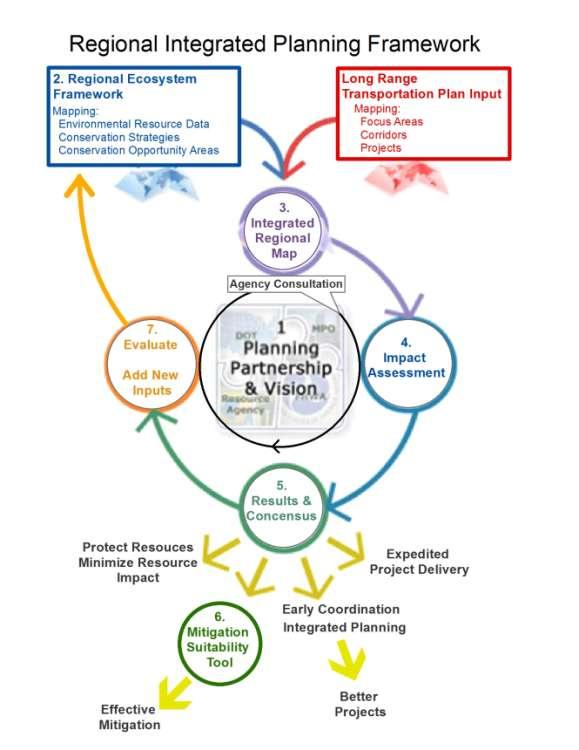
11 Transportation Planning and Environmental Linkage Aspects of the SPC 2040 LRTP PHOTO Presented to PA Agency Coordination Meeting May 27, 2015 Ryan Gordon, Planner SPC 11

12 Planning and Environmental Linkage Linking Planning and NEPA 12
13 PEL Regulations for Metropolitan Transportation Plans MAP-21 requires the MPO to consult with the regulatory and resource agencies responsible for land use management, natural resources, environmental protection, conservation, and historic preservation concerning the development of the transportation plan, (23 C.F.R (g)) Consultations shall involve comparison of transportation plans to inventories of natural or historic resources, if available. (23 C.F.R (g)(1)) Consultations shall involve comparison of transportation plan with State conservation plans or maps, if available (23 C.F.R (g)(2)) MAP-21 requires a discussion of types of potential environmental mitigation activities and potential areas to carry out these activities, including activities that may have the greatest potential to restore and maintain the environmental functions affected by the plan. The discussion may focus on policies, programs, or strategies, rather than at the project level. (23 C.F.R (f)(7)) 13

14 SPC PEL Approach Update and expand our spatial data holdings to include more environmental resource data Conduct Early Coordination Efforts with Resource Agencies (Develop a consultation web site) Develop spatial analysis methods to screen projects based on the environmental resource data sets Develop PEL Addendum/Report for the LRP Develop planning tools to support PEL initiatives Regional ecological framework Mitigation planning 14
15 Planning and Environmental Linkage Addendum Outline: 1 Introduction 2 Regulatory Context 3 Agency Consultation 4 Resource Inventory 5 Existing State Conservation Plans and Maps 6 Regional Ecological Framework 7 Environmental Screening - Integrated Regional Map 8 Potential Environmental Mitigation - Pilot Wetland Mitigation Planning Tool 9 Summary and Next Steps
16 Consultation Activity Consultation Activities Agency Consultation Plan Review with FHWA July 2014 Agency Consultation Invitation Letters Distributed October 9, 2014 Face to Face Consultation Meetings with Agency Representatives from within the SPC Region (US Army Corps of Engineers, PA Department of Environmental Protection, PA Department of Conservation and Natural Resources, PA Historic and Museum Commission, Natural Heritage Program) Date Late October November 2014 Phone and/or consultation with additional agency contacts outside of the SPC region. Agency Consultation Website established including draft chapters of the environmental Addendum for download Sample Project Screening results posted to the Agency Consultation Website with downloadable preliminary constraints maps. Consultation Meetings with PennDOT Environmental Managers (Districts 10-0, 11-0, 12-0) Early 2015 February 18, 2015 April 10, 2015 April May 2015 Statewide Agency Coordination Meeting presentation May 27 th 2015 LRTP Public Comment Period Comments potentially received on the Draft LRTP from Federal, State, or Tribal Agencies May 13, 2015 to June 12,
17 ((Consultation Website)) Review what is on the website for download *RETURN TO PP 17
18 Planning and Environmental Linkage Addendum Outline: 1 Introduction 2 Regulatory Context 3 Agency Consultation 4 Resource Inventory 5 Existing State Conservation Plans and Maps 6 Regional Ecological Framework 7 Environmental Screening - Integrated Regional Map 8 Potential Environmental Mitigation - Pilot Wetland Mitigation Planning Tool 9 Summary and Next Steps

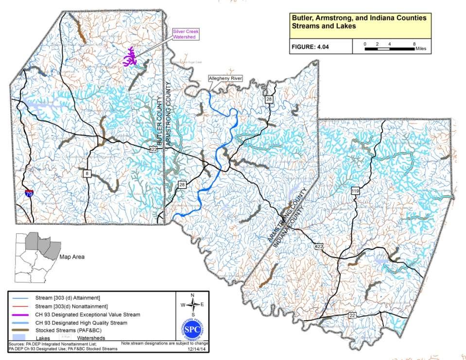
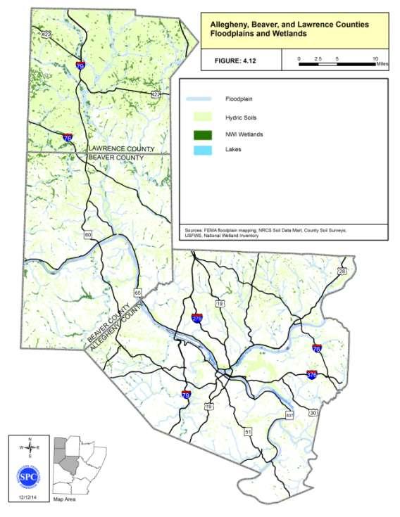
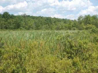
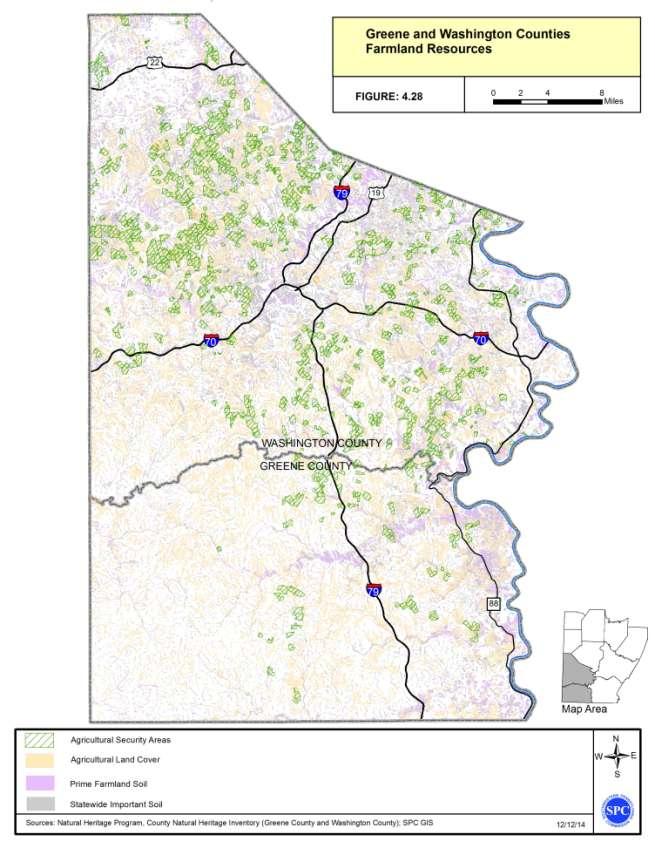
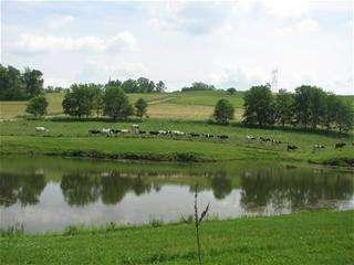
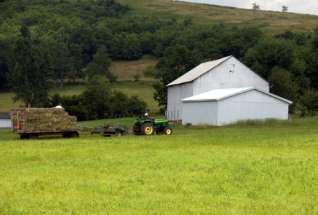
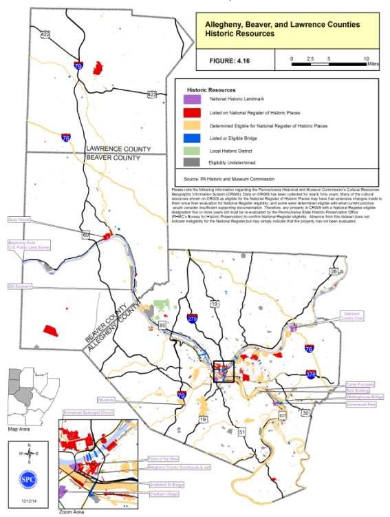
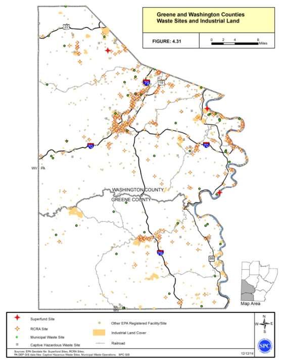
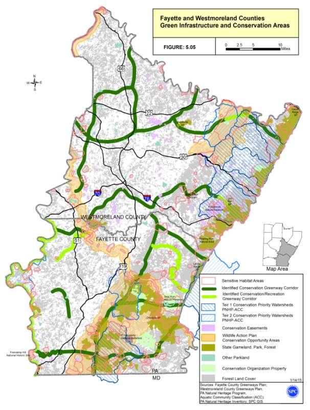
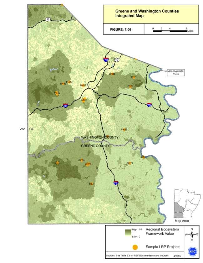
19 Linking Planning and NEPA Resource Inventory Mapping Sub areas for Inventory maps Different Resource Inventory Maps in each Sub area Streams Wetlands Indicators T&E Species Indicators Farmlands Resources Protected Lands Historic Resources Industrial Areas & Waste Site Indicators 19
20 20
21 21


22 22
23 23
24 24
25 25

26 26
27 Planning and Environmental Linkage Addendum Outline: 1 Introduction 2 Regulatory Context 3 Agency Consultation 4 Resource Inventory 5 Existing State Conservation Plans and Maps 6 Regional Ecological Framework 7 Environmental Screening - Integrated Regional Map 8 Potential Environmental Mitigation - Pilot Wetland Mitigation Planning Tool 9 Summary and Next Steps


28 Existing State Conservation Plans and Maps Various state financed (DCNR) River and Watershed Conservation Plans PA DEP Statewide Water Resources Plan, State financed (DCNR) county greenway plans PA Game Commission and PA Fish and Boat Commission, Pennsylvania Comprehensive Wildlife Conservation Strategy, Pennsylvania Historic and Museum Commission, Pennsylvania Preservation Plan Associated Conservation Opportunity Areas, Pennsylvania Historic and Museum Commission, Pennsylvania Preservation Plan Western PA Conservancy, PA Aquatic Community Classification, Western PA Conservancy, Conservation Priorities, DCNR Bureau of Forestry, Statewide Forest Resource Assessment, DCNR Bureau of Forestry, Pennsylvania Forest Strategies, Natural Heritage Inventories, County Inventories DCNR Conservation Landscape Initiative Areas DCNR Heritage Areas PA Fishing and Boating Access Strategy plan 28

29 29
30 30
31 Planning and Environmental Linkage Addendum Outline: 1 Introduction 2 Regulatory Context 3 Agency Consultation 4 Resource Inventory 5 Existing State Conservation Plans and Maps 6 Regional Ecological Framework 7 Environmental Screening - Integrated Regional Map 8 Potential Environmental Mitigation - Pilot Wetland Mitigation Planning Tool 9 Summary and Next Steps


32 Regional Ecological Framework and Regional Integrated Map Executive Order on Facilitation of Cooperative Conservation Eco-Logical: An Ecosystem Approach to Developing Infrastructure Projects Nine Federal Agencies recommend a collaborative, integrated, watershed or regional-scale approach to decision-making during transportation and infrastructure planning Many other Regional MPOs and State DOTs utilizing REFs/Integrated maps in LRTPs and mitigation planning Atlanta Regional Commission - Michigan DOT Charlottesville MPO - Oregon DOT Houston Galveston Area Council - Kentucky Transportation Cabinet TRB SHRP2: 2013 Guidance for Integrated Ecological Frameworks MAP-21: Optional Regional Programmatic Mitigation Plans
33
34 Regional Ecological Framework WHAT: REF is a GIS that integrates natural resource inventory data, conservation priorities maps/plans, which form an ecological framework of the region. WHY: Establish a region-wide ecological and regulatory basis to inform planning and assess potential impact. HOW: Collect/Update available environmental inventory spatial data. Aggregate environmental inventory data into a model showing the relative value and spatial distribution of ecological and regulated natural resources in the region. Consultations with resource agencies to refine valuations and improve accuracy of the model.
35 35
36 Planning and Environmental Linkage Addendum Outline: 1 Introduction 2 Regulatory Context 3 Agency Consultation 4 Resource Inventory 5 Existing State Conservation Plans and Maps 6 Regional Ecological Framework 7 Environmental Screening - Integrated Regional Map 8 Potential Environmental Mitigation - Pilot Wetland Mitigation Planning Tool 9 Summary and Next Steps


 Realistic new TIP project candidates with PE")

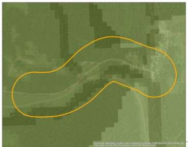
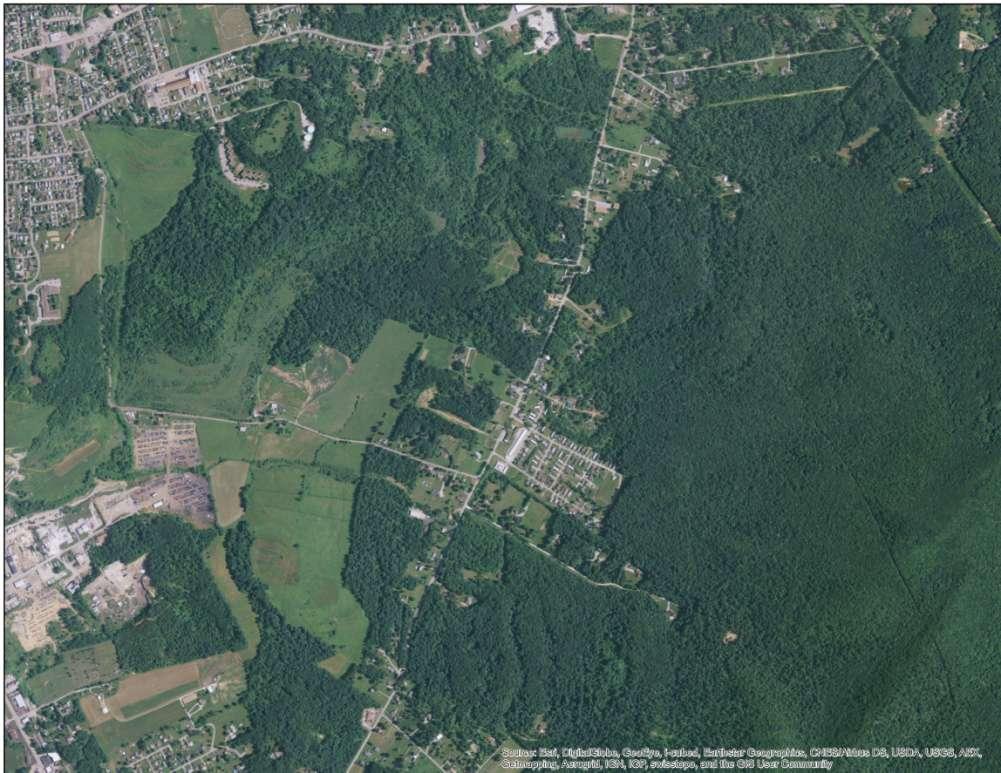
37 Project Screenings Conducted to compare environmental inventory to a sample of planned transportation projects Over 60 environmental inventory data layers (more detailed than the overview inventory) Sample projects (Timing and potential Impact) Prescreened 150 TYP projects against REF selecting a sample of 55 to conduct detailed analysis Project types with the greatest potential to have environmental impacts (Bridges & New ROW projects) Realistic new TIP project candidates with PE phases likely to be on the next TIP. Project screening is being conducted at a time when LPN information is most beneficial. PennDOT LPN Level 2 screening forms completed on sample projects 37
38 38
39 39

40 Aggregated layers and scores 40
41 Planning and Environmental Linkage Addendum Outline: 1 Introduction 2 Regulatory Context 3 Agency Consultation 4 Resource Inventory 5 Existing State Conservation Plans and Maps 6 Regional Ecological Framework 7 Environmental Screening - Integrated Regional Map 8 Potential Environmental Mitigation - Pilot Wetland Mitigation Planning Tool 9 Summary and Next Steps

 resources Farmlands Created table")

42 Types of Potential Mitigation Activities and Potential Areas to Carry Out Activities Photos of mitigation Approach to focus on potential strategies and options for mitigation activities for the key resource types in the SPC region Focused on a few Resources: Wetlands Streams Threatened and Endangered Species Cultural Resources Other Section 4(f) resources Farmlands Created table for each of the resources listed mitigation options associated with that resource including potential locations and criteria Included discussion of Advanced Compensatory mitigation where applicable 42

43 Example of the Potential Mitigation Activities Tables Historic Resources (other resources follow same format) Types of Potential Mitigation Activities listed for both individual project and Advanced compensatory mitigation Information provided related to areas to carryout these activities 43
44 Planning and Environmental Linkage Addendum Outline: 1 Introduction 2 Regulatory Context 3 Agency Consultation 4 Resource Inventory 5 Existing State Conservation Plans and Maps 6 Regional Ecological Framework 7 Environmental Screening - Integrated Regional Map 8 Potential Environmental Mitigation - Pilot Wetland Mitigation Planning Tool 9 Summary and Next Steps
45
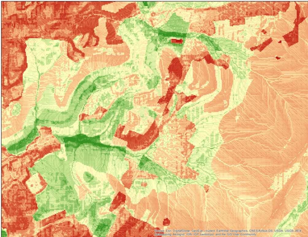
46 Pilot Wetland Mitigation Planning Tool WHAT: A planning tool that will assist in identification of suitable mitigation sites for selected resources (wetlands). WHY: Meet MAP-21 requirements to identify potential locations for wetland mitigation. Assist PennDOT and other project sponsors in identifying suitable locations for mitigation sites or bank sites. To assess available data for site suitability to ensure that mitigation decisions are location efficient and maximizing ecological benefits. HOW: Utilize existing site suitability methodology and DEP questionnaire to determine suitability criteria using GIS Utilizing raster datasets (30 ft resolution) to develop site suitability criteria for selected resources and selected mitigation goal (e.g.: stream, restoration). Aggregate suitability criteria data into a model showing the relative value and spatial distribution of suitable locations for mitigation of the selected resource in the region. Conduct Consultations with resource agencies to refine valuations and improve accuracy of the model.
47 Example Project Area 47

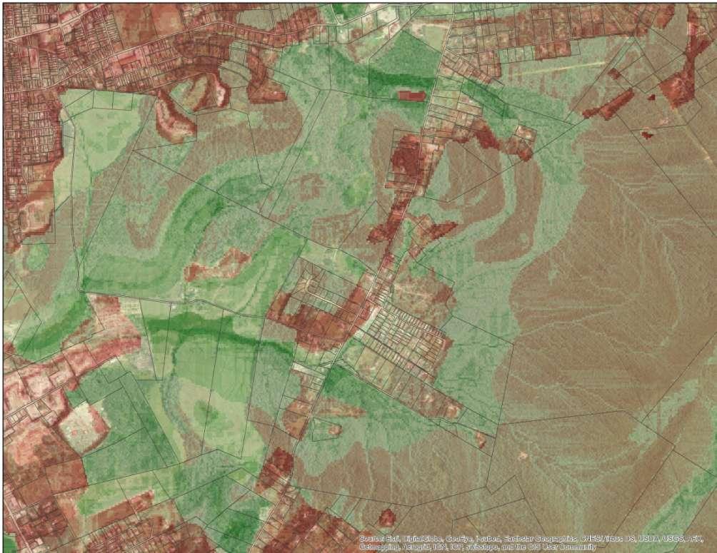
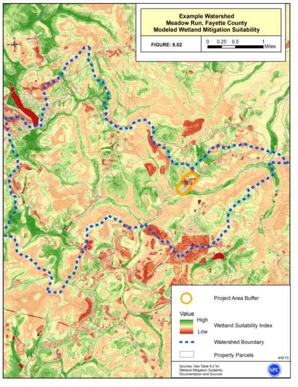
48 Proximity to existing wetlands 48

49 Areas of Hydric Soils 49

50 In Protected Land or Proximity 50

51 Existing Conservation Easements 51

52 Existing Land Use 52

53 Watersheds targeted for wetland restoration 53

54 Distance from existing streams 54

55 Soil Survey Drainage Class Very Poorly Drained Poorly Drained 55

56 Slope 0 to 2 degrees 2.1 to 5 degrees 56

57 Topographic Wetness Index 57

58 Modeled Suitability for Wetland Mitigation 58

59 Modeled Suitability for Wetland Mitigation Property Parcels 59
60 Modeled Suitability for Wetland Mitigation Property Parcels 60
61 Elevation 1,040 ft Elevation 2,000 ft 61
62 Modeled Suitability for Wetland Mitigation Property Parcels 62
63 Modeled Suitability for Wetland Mitigation Property Parcels 63
64 64


65 SPC PEL Activities - Next Steps Continue to integrate LPN into the Pre-TIP planning with 2017 TIP update. Partnering with our District Environmental Units to pilot validation of the wetland mitigation suitability tool. Providing preliminary constraint maps on corridor studies with PennDOT Districts Sharing REF with County planners for use in comprehensive plans/greenway plans and project development. Collaboration with WPC to conduct a regional update of our Natural Heritage data (pending grant) Investigate development of more mitigation planning tools 65


66 Feedback/Discussion/Questions Ryan Gordon Planner, SPC Doug Smith Transportation Planning Director, SPC 66
DRAFT MAP AMENDMENT FLU 04-4
 DRAFT MAP AMENDMENT FLU 04-4 SW 24 TH AVENUE ROADWAY CORRIDOR The University of Florida participates with the Metropolitan Transportation Planning Organization (MTPO) in its responsibilities for the continuing,
Countywide Green Infrastructure
 Montgomery County s Countywide Green Infrastructure F U N C T I O N A L M A S T E R P L A N The Maryland National Capital Park and Planning Commission INFRASTRUCTURE An underlying base or foundation especially
Conservation Corridor Base and Thematic Maps
 Conservation Corridor Base and Thematic Maps August 20, 2010 This project is funded in part by the Virginia Coastal Zone Management Program at the Department of Environmental Quality through Grant #NAO9NOS4190163
IMPLEMENTING SOMERSET COUNTY S INVESTMENT FRAMEWORK
 IMPLEMENTING SOMERSET COUNTY S INVESTMENT FRAMEWORK SMART CONSERVATION THROUGH SMART GROWTH NJ LAND CONSERVATION RALLY March 22, 2014 Laurette Kratina, PP, AICP, Supervising Planner Somerset County Planning
National Association of Conservation Districts. Kris Hoellen Vice President, Sustainable Programs The Conservation Fund September 19, 2013
 National Association of Conservation Districts Kris Hoellen Vice President, Sustainable Programs The Conservation Fund September 19, 2013 Our Mission The Conservation Fund forges partnerships to conserve
Transportation Research Center
 Increasing Design Flexibility in the AASHTO Green Book Your Department Name Presentation to AASHTO Subcommittee on Design Doug Harwood, MRIGlobal July 2017 Transportation Research Center Resolution of
ITS Concept Development Activity Descriptions
 ITS Concept Development Activity Descriptions October 2015 Procedures are subject to change without notice. Check the NJDOT website to ensure this is the current version. Table of Contents Concept Development
STEWARDSHIP OF LONG ISLAND SOUND S ECOLOGICAL AND RECREATIONAL RESOURCES
 STEWARDSHIP OF LONG ISLAND SOUND S ECOLOGICAL AND RECREATIONAL RESOURCES Robin Kriesberg, Save the Sound, Inc. Thomas Halavik, US Fish and Wildlife Service Coastal Program An Initiative to Identify, Protect
PD&E STUDY SR 9/I-95 FROM SOUTH OF SR 870/COMMERCIAL BOULEVARD TO NORTH OF CYPRESS CREEK ROAD FM # ETDM 14222
 PD&E STUDY SR 870/COMMERCIAL BOULEVARD TO NORTH OF CYPRESS CREEK ROAD FM # 435808-1-22-02 ETDM 14222 WELCOME TO THE KICK-OFF MEETING May 24, 2016 1 1 2 3 4 5 6 PLANNING PROJECT DEVELOPMENT AND ENVIRONMENT
Integration of Planning & Environmental Analysis in Transportation
 Integration of Planning & Environmental Analysis in Transportation How Natural Resources Conservation Fits into SAFETEA-LU Planning Rules Transportation Research Board Annual Meeting January 2008 Jeff
495/MetroWest Development Compact Plan Citizen Planner Training Collaborative Conference. March 17, 2012
 495/MetroWest Development Compact Plan Citizen Planner Training Collaborative Conference March 17, 2012 Project Process Local and Regional Priority Areas Growth Scenarios Transportation Investment Categories
Arlington, Virginia is a worldclass
 EXECUTIVE S U M M A RY Arlington maintains a rich variety of stable neighborhoods, quality schools and enlightened land use policies, and received the Environmental Protection Agency s highest award for
An Update on the Air Force Pilot Project: Developing the Florida Strategic Plan for Sustaining Military Readiness through Conservation Partnerships
 An Update on the Air Force Pilot Project: Developing the Florida Strategic Plan for Sustaining Military Readiness through Conservation Partnerships 18 November 2015 Quick Overview Pilot Project Background
Summary of Action Strategies
 Strategic Action Plan 6 Summary of Action Strategies Action Strategy Categories: 1. Organization and Management 2. Implementation 3. Marketing and Promotion This chapter summarizes all of the action strategies
SUMMARY. Support the Southeast Arkansas Regional Intermodal Facility.
 SUMMARY THE I-69 LOCATION STUDY The proposed I-69 Location Study from El Dorado to McGehee, Arkansas, represents one section (Section of Independent Utility No. 13) of the nationally designated I-69 Corridor
Oakland County s Green Infrastructure Vision. L. Brooks Patterson Oakland County Executive
 Oakland County s Green Infrastructure Vision L. Brooks Patterson Oakland County Executive Southeast Michigan 20 miles northwest of Detroit Consists of 910 square miles Population of 1.2 million More than
Outlawing Sprawl. Pennsylvania Chapter American Planning Association October 6, 2009
 Outlawing Sprawl Pennsylvania Chapter American Planning Association October 6, 2009 Presented by: Ronald T. Bailey, AICP Executive Director Chester County Planning Commission Location: 2009 PA Chapter
NEW REGIONAL OFFICIAL PLAN HIGH LEVEL PROCESS & FRAMEWORK
 NEW REGIONAL OFFICIAL PLAN HIGH LEVEL PROCESS & FRAMEWORK Why A New Official Plan Originally the role of Regionally Planning and content of Regional Official Plan (1970s) primarily focused on protecting
TABLE OF CONTENTS. Transportation Chapter 1 - Introduction and Purpose of Planning to 1-3. Utilities
 Chapter 1 - Introduction and Purpose of Planning... 1-1 to 1-3 Pennsylvania Municipalities Planning Code (Act 247)...1-1 Previous County Planning Activities...1-1 Objectives of the Plan...1-2 Elements
This page intentionally blank.
 This page intentionally blank. Parks, Recreation, and Open Space Chapter Relationship to Vision Vision Parks, Recreation and Open Space Chapter Concepts County Government. County government that is accountable
PREPARED FOR: PLATTEVIEW ROAD CORRIDOR STUDY EXECUTIVE SUMMARY
 PREPARED FOR: PLATTEVIEW ROAD CORRIDOR STUDY EXECUTIVE SUMMARY SEPTEMBER 2016 Introduction The Platteview Road Corridor Study was led by the Metropolitan Area Planning Agency (MAPA) with assistance from
RECREATION, OPEN SPACE AND GREENWAYS ELEMENT GOALS, OBJECTIVES, AND POLICIES
 RECREATION, OPEN SPACE AND GREENWAYS ELEMENT GOALS, OBJECTIVES, AND POLICIES GOAL R-1: DEVELOP A RECREATION, OPEN SPACE AND GREENWAYS SYSTEM AS AN INTEGRAL COMPONENT OF AN OVERALL, COUNTY-WIDE ECONOMIC
Atlanta BeltLine Corridor Environmental Study. Scoping Meeting August 2008
 Atlanta BeltLine Corridor Environmental Study Scoping Meeting August 2008 What Will We Be Discussing Today? Study Overview - How Did We Get Here? - What Is the Study About? - Who Is Involved? - Where Is
PREVIOUS PUBLIC PARTICIPATION BRIEF October 2014
 Comprehensive Planning During the development of the county comprehensive plan, Cultivating Community: A Plan for Union County s Future from 2007 through 2009, and three concurrent multi municipal plans
Growth Management Planning in the Central Puget Sound Region. Today s Presentation. Puget Sound Region. New Partners for Smart Growth
 Growth Management Planning in the Central Puget Sound Region New Partners for Smart Growth Denver, CO January 2006 Today s Presentation Regional growth management in central Puget Sound, WA Regional geographies
NJ Habitat Connectivity Initiative
 NJ Habitat Connectivity Initiative Full Working Group Update #1 Spotted Salamander Crossing Road in Northern NJ Wildlife Habitat Connectivity Initiative A strategic plan to reconnect New Jersey s landscape
1.0 INTRODUCTION 1.1 TH 14 WEST STUDY AREA Project Description Functional Classification Purpose of the Project
 1.0 INTRODUCTION 1.1 TH 14 WEST STUDY AREA 1.1.1 Project Description The Trunk Highway (TH) 14 West Corridor is a two-lane roadway approximately 22 miles in length. Located in Nicollet County, the corridor
PROJECT BACKGROUND. Preliminary Design Scope and Tasks
 PROJECT BACKGROUND Preliminary Design Scope and Tasks The purpose of this Study is the development of preliminary designs for intersection improvements for Trunk Highway (TH) 36 at the intersections of
TRANSPORTATION ELEMENT GOALS, OBJECTIVES, AND POLICIES
 TRANSPORTATION ELEMENT GOALS, OBJECTIVES, AND POLICIES GOAL 2 The City shall provide a safe, convenient, effective, and energy efficient multimodal transportation system which is coordinated with the Future
Preface. Erie. Scranton. Allentown. Pittsburgh. Harrisburg. Philadelphia
 The Southern Alleghenies Region The Southern Alleghenies Region spans the Laurel Highlands and Allegheny Front in the west across the Appalachians to the east. It is comprised of Blair, Bedford, Cambria,
Transportation Planning to Protect Lancaster County s Heritage Resources
 Transportation Planning to Protect Lancaster County s Heritage Resources Presented by Harriet Parcells, AICP Senior Transportation Planner Lancaster County Planning Commission July 10, 2015 Topics to be
Westport Master Plan. Town of Westport. Master Plan Master Plan Update Committee. Westport, Massachusetts
 Town of Westport Master Plan 2004 Master Plan Update Committee Westport, Massachusetts Open Space and Recreation 5-1 Table of Contents Table of Contents... i List of Tables... ix List of Figures... ix
Planning Roles. Responsibilities
 Lesson 3 Planning Roles & Responsibilities 3-1 Learning Outcomes Identify and describe transportation and land use planning processes Describe the relationships among these processes and how they can be
Photo by Carlton Ward Jr. Executive Summary
 Photo by Carlton Ward Jr. Executive Summary The Cooperative Conservation Blueprint (Blueprint) is a multi-partner strategic conservation process developed by the Florida Fish and Wildlife Commission (FWC)
Mississippi Skyway Preliminary Engineering Report
 EXECUTIVE SUMMARY Mississippi Skyway Preliminary Engineering Report CITY OF RAMSEY, MINNESOTA DECEMBER 2014 City of RAMSEY EXECUTIVE SUMMARY Project Need and Intent The Mississippi Skyway pedestrian bridge
NJ Department of Environmental Protection
 NJ Department of Environmental Protection COASTAL AND LAND USE PLANNING New Jersey Coastal Management Program Covers NJ coastal waters to limit of tidal influence including 239 municipalities in 19 counties,
2040 LUP is a part of the Comprehensive Plan and carries the same legal authority. Economic Challenges
 1.1. Guiding Anchorage s Growth Where will new residents settle over the next two decades? Where will people work, shop, and play? Will there be enough room to grow? How will Anchorage look? Will growth
Northern Branch Corridor SDEIS March Table of Contents
 Table of Contents Executive Summary... ES-1 ES.1 Introduction... ES-1 ES.2 Project Background... ES-1 ES.3 Purpose and Need... ES-5 ES.4 Alternatives... ES-6 ES.5 Operating Plan... ES-11 ES.6 Cost Analysis...
ADOPTION OF THE REVISED OPEN SPACE AND CONSERVATION ELEMENT OF THE GENERAL PLAN
 TO: FROM: SUBJECT: Honorable Mayor and City Council Planning Department ADOPTION OF THE REVISED OPEN SPACE AND CONSERVATION ELEMENT OF THE GENERAL PLAN RECOMMENDATION: It is recommended that the City Council:
Green Infrastructure. by Karen Engel, NYS DEC. NYS Department of Environmental Conservation
 Green Infrastructure by Karen Engel, NYS DEC What is Green Infrastructure? For some it s all about water Green Infrastructure techniques use soils and vegetation to infiltrate, evapotranspirate, and/or
RECREATION AND OPEN SPACE ELEMENT GOALS, OBJECTIVES, AND POLICIES
 RECREATION AND OPEN SPACE ELEMENT GOALS, OBJECTIVES, AND POLICIES Goal 7 To provide park facilities, recreation programs, and open space resources that are safe, adequate, and accessible to all City residents,
The West Vaughan Employment Area Secondary Plan Policies
 Part 2: The West Vaughan Employment Area Secondary Plan Policies 2.1 General Policies It is the policy of Council: 2.1.1. That the West Vaughan Employment Area (the WVEA), identified on Schedule 1, will
Complete Streets in Lancaster County
 Complete Streets in Lancaster County PRESENTED BY: Robert Bini, AICP Director for Transportation Planning November 14, 2017 Lancaster County is a growing county of over 534,000 and the bottom line is...
TOWN OF BETHLEHEM OPEN SPACE CONSERVATION PLAN PUBLIC MEETING: OCTOBER 12, 2017
 TOWN OF BETHLEHEM OPEN SPACE CONSERVATION PLAN PUBLIC MEETING: OCTOBER 12, 2017 Welcome and Agenda 6:00 6:45: Open House, Part One 6:45 7:15: Presentation and Questions 7:15 8:00: Open House, Part Two
Longmeadow Parkway Fox River Bridge Corridor. August 6, 2015
 Longmeadow Parkway Fox River Bridge Corridor August 6, 2015 Longmeadow Parkway Bridge Corridor 5.6 miles from Huntley Road to IL 62 Unique municipal/county/state/federal partnership Links Randall Road
CHAPTER 1 Introduction
 CHAPTER 1 Introduction From sea to summit, Lane County covers almost 4,800 square miles of diverse Oregon landscape. Stretching from the Pacific Ocean through the Coastal Range, the Willamette Valley to
Joint Meeting City Council and the Plan Commission. September 1st, 2015
 Joint Meeting City Council and the Plan Commission September 1st, 2015 1 The City Plan Commission shall recommend a City Plan for the physical development of the City Article IX Section 2 of the City of
The Hartford Line Transit-Oriented Development (TOD) Action Plan. Maxwell L. Sokol, AICP WSP USA, Lead Planner New York, NY
 Action Plan. Maxwell L. Sokol, AICP WSP USA, Lead Planner New York, NY") The Hartford Line Transit-Oriented Development (TOD) Action Plan Maxwell L. Sokol, AICP WSP USA, Lead Planner New York, NY Key Presentation Take-Aways Deliberately build upon prior efforts at the local,
The Hartford Line Transit-Oriented Development (TOD) Action Plan Maxwell L. Sokol, AICP WSP USA, Lead Planner New York, NY Key Presentation Take-Aways Deliberately build upon prior efforts at the local,
Creating Complete Roadway Corridors:
 Creating Complete Roadway Corridors: The AASHTO Guide to Transportation Landscape Architecture and Environmental Design NCHRP Project 15-33 Status Report AASHTO Standing Committee on Design Technical Committee
Regional Open Space Conservation Plan Putting the Plan into Action
 Regional Staff Committee June 21, 2018 Regional Open Space Conservation Plan Putting the Plan into Action Comments on the draft Include more discussion of urban open space Benefits, challenges to maintaining/increasing
Green Infrastructure Policies and Ordinances
 Green Infrastructure Policies and Ordinances October 23, 2013 By Karen Firehock, Green Infrastructure Center 2013 Georgia Urban Forest Council s 23 rd Annual Conference The mission of the nonprofit Green
Ottawa County Parks, Recreation & Open Space Plan. February, 2006
 2006 Ottawa County Parks, Recreation & Open Space Plan February, 2006 TABLE OF CONTENTS ACKNOWLEDGMENTS.................................................... v PLAN ADOPTION..........................................................vi
Location. Need GOAL 14 URBAN GROWTH BOUNDARY. Urban Planning in Oregon 7/8/2015
 Urban Planning in Oregon June 24, 2015 Redmond, Oregon Gordon Howard, DLCD Urban Planning Specialist GOAL 14 URBAN GROWTH BOUNDARY To provide for an orderly and efficient transition from rural to urban
SEWRPC. Joint Meeting of the Advisory Committees on Regional Land Use Planning and Regional Transportation Planning APRIL 26, 2018
 SEWRPC Joint Meeting of the Advisory Committees on Regional Land Use Planning and Regional Transportation Planning APRIL 26, 2018 WISCONSIN DEPARTMENT OF TRANSPORTATION BRETT WALLACE, FOXCONN PROJECT DIRECTOR
COLVER ROAD INDUSTRIAL CONCEPT PLAN
 COLVER ROAD INDUSTRIAL CONCEPT PLAN A CONCEPTUAL LAND USE AND TRANSPORTATION PLAN FOR TA-4 AN URBAN RESERVE AREA OF THE CITY TALENT City of Talent Adopted by City Council Resolution No., June, 2015 PART
DISCUSSION TOPIC: ST JOHNS RIVER & ITS TRIBUTARIES (BPII) 2030 COMPREHENSIVE PLAN POLICES AND REGULATORY FRAMEWORK
 2030 COMPREHENSIVE PLAN POLICES AND REGULATORY FRAMEWORK") DISCUSSION TOPIC: ST JOHNS RIVER & ITS TRIBUTARIES (BPII) 2030 COMPREHENSIVE PLAN POLICES AND REGULATORY FRAMEWORK St. John s River & Its Tributaries Issue Summary: The St. Johns River is an important
DISCUSSION TOPIC: ST JOHNS RIVER & ITS TRIBUTARIES (BPII) 2030 COMPREHENSIVE PLAN POLICES AND REGULATORY FRAMEWORK St. John s River & Its Tributaries Issue Summary: The St. Johns River is an important
Oregon SCORP. Assessing Recreation Demand & Supply
 2013-2017 Oregon SCORP Assessing Recreation Demand & Supply SORP Conference: April 13, 2015 2013-2017 Oregon SCORP Supply/Demand Planning Components A County-Level and Regional Planning Approach Oregon
Scope of Services. River Oaks Boulevard (SH 183) Corridor Master Plan
 Corridor Master Plan") Scope of Services River Oaks Boulevard (SH 183) Corridor Master Plan PROJECT AREA The project area consists of the River Oaks Boulevard (SH 183) corridor bounded by SH 199 at the northern end and the Trinity
Scope of Services River Oaks Boulevard (SH 183) Corridor Master Plan PROJECT AREA The project area consists of the River Oaks Boulevard (SH 183) corridor bounded by SH 199 at the northern end and the Trinity
CITY OF CHARLOTTESVILLE, VIRGINIA CITY COUNCIL AGENDA
 CITY OF CHARLOTTESVILLE, VIRGINIA CITY COUNCIL AGENDA Agenda Date: December 16, 2013 Action Required: Adoption of Resolution Presenter: Staff Contacts: Title: James E. Tolbert, AICP, Director of NDS James
Statewide Greenways Vision
 Greenways Vision The formation of a greenways vision is based on a thorough analysis of the current state of recreation and open space in a region and the existing pressures that threaten it. Lehigh and
Regional Open Space Conservation Plan Putting the Plan into Action
 Regional Open Space Conservation Plan Putting the Plan into Action Growth Management Policy Board July 5, 2018 Study area Regional Open Space Network Regional Trails: 339 miles Conservation Needs Not in
WELCOME TO THE CHOUTEAU GREENWAY DESIGN, DEVELOPMENT AND CONSTRUCTION WORKING GROUP!
 WELCOME TO THE CHOUTEAU GREENWAY DESIGN, DEVELOPMENT AND CONSTRUCTION WORKING GROUP! Chouteau Greenway Steering Committee and Working Groups Overview Overview January 9, 2019 Chouteau Greenway will transform
The transportation system in a community is an
 7 TRANSPORTATION The transportation system in a community is an important factor contributing to the quality of life of the residents. Without a sound transportation system to bring both goods and patrons
PDS June 1, 2016 Page 1. Planning and Development Committee. MEETING DATE: Wednesday, June 01, 2016
 Page 1 REPORT TO: Planning and Development Committee MEETING DATE: Wednesday, June 01, 2016 SUBJECT: ROPA 12: Project Initiation Report Regional Official Plan Amendment (ROPA # 12) Watercourse Policies
Western Pennsylvania Conservancy Clairton & Harrison Community Greening Assessment Projects Request for Proposals July 2018
 Western Pennsylvania Conservancy Clairton & Harrison Community Greening Assessment Projects Request for Proposals July 2018 Proposal Information The Western Pennsylvania Conservancy (WPC) is seeking proposals
Staff will be providing an overview of the project need, purpose and intent for consideration as part of the Amendment cycle.
 Agenda Item D-2 City of Tacoma Planning and Development Services To: Planning Commission From: Stephen Atkinson, Planning Services Division Subject: Open Space Corridors Project Meeting Date: March 1,
Chapter 13: Implementation Plan
 Implementation A. Introduction The Implementation Plan, in table form on the following pages, provides a summary of all the Action Items recommended in Chapters 2 through 12. The table also indicates which
TRANSPORTATION AND LAND USE
 CHAPTER 10 TRANSPORTATION AND LAND USE Transportation and land use are intimately linked. The expansion of a highway typically spurs housing, employment growth and land development in the communities that
7.0 SOCIAL, ECONOMIC, AND ENVIRONMENTAL ISSUES
 7.0 SOCIAL, ECONOMIC, AND ENVIRONMENTAL ISSUES The following list of social, economic, and environmental issues have been identified based on a preliminary inventory of resources in the project area, an
Transportation Systems and Utility Infrastructure
 77 Audience Local and regional units of government, Landowners and developers, Community and citizen organizations, and Transportation/utility planners and engineers. Overview Transportation systems and
NORTH-SOUTH CORRIDOR STUDY EXECUTIVE SUMMARY. Executive Summary
 Executive Summary Background As congestion continues to affect mobility in the region, the Ozarks Transportation Organization (OTO) is particularly concerned with traffic movement. The North-South Corridor
Regional and Local Perspectives
 Regional and Local Perspectives Transportation Engineering and Safety Conference Tom Zilla Principal Transportation Planner Centre County Metropolitan Planning Organization We are here! We are here! 1
New Official Plan Quest November 2013
 City of Markham New Official Plan Quest November 2013 Building Markham s Future Together - 6 Key Strategic Priorities 1. Growth - Managing our Growth 2. Transportation/Transit - Improving transportation
Master Environmental Servicing Plan & Secondary Plan
 East Side Lands Stage 2 1 Master Environmental Servicing Plan & Secondary Plan Public Information Centre #1 June 16, 2016 Welcome! Today s Agenda Please sign in at the front desk. 5:30 pm 6:30 pm: Open
AASHTO Board of Directors. Standing Committees (Functional Areas): Finance and Administration. Highway Traffic Safety. Performance.
: Finance and Administration. Highway Traffic Safety. Performance.") AASHTO Board of Directors Executive Committee Standing Committees (Modal): Aviation Standing Committees (Functional Areas): Environment Special Committees: Intermodal and Economic Expansion Highways Finance
AASHTO Board of Directors Executive Committee Standing Committees (Modal): Aviation Standing Committees (Functional Areas): Environment Special Committees: Intermodal and Economic Expansion Highways Finance
State Highway 121 Southwest Parkway. Fort Worth s Transportation Success Story in Design and Cooperation
 State Highway 121 Southwest Parkway Fort Worth s Transportation Success Story in Design and Cooperation Greater Fort Worth Association of Realtors October 24, 2007 Presented by: Dan Lamers, P.E. North
Onondaga County Sustainable Streets Project. Onondaga County Planning Federation June 7, Onondaga County Sustainable Streets Project 1
 Onondaga County Sustainable Streets Project Onondaga County Planning Federation June 7, 2012 Onondaga County Sustainable Streets Project 1 Sustainable Streets 1. Introduction to the SMTC 2. Sustainable
implementation r expression in landscape
 6 ubc okanagan implementation campus plan r expression in landscape 68 6 implementation campus plan sections The Campus Plan supports the academic mission, values and commitments of the University by providing
Vaughan Metropolitan Centre (VMC) Black Creek Renewal CLASS ENVIRONMENTAL ASSESSMENT
 Black Creek Renewal CLASS ENVIRONMENTAL ASSESSMENT") PUBLIC INFORMATION CENTRE Vaughan Metropolitan Centre (VMC) Black Creek Renewal Wednesday, May 10, 2017 6:00 p.m. to 8:00 p.m. Add photo Project Management, Environmental Assessment, Stormwater Management
PUBLIC INFORMATION CENTRE Vaughan Metropolitan Centre (VMC) Black Creek Renewal Wednesday, May 10, 2017 6:00 p.m. to 8:00 p.m. Add photo Project Management, Environmental Assessment, Stormwater Management
ROLE OF LANDSCAPE CONSERVATION COOPERATIVES IN EVERGLADES RESTORATION
 ROLE OF LANDSCAPE CONSERVATION COOPERATIVES IN EVERGLADES RESTORATION GEER April 2017 Steve Traxler 1, Todd Hopkins 1, Beth Stys 2 1 US Fish and Wildlife Service 2 Florida Fish & Wildlife Conservation
Subject: Hendry County Evaluation and Appraisal Report Letter of Understanding - Identification of Major Issues
 HENDRY COUNTY PLANNING & ZONING DEPARTMENT POST OFFICE BOX 2340 165 S. LEE STREET LABELLE, FLORIDA 33975 (863) 675-5240 FAX: (863) 675-5317 SUNCOM 744-4750 November 16, 2007 Mr. Mike McDaniel, Chief Office
systems is available on the Colorado Wetland Information Center (CWIC) website.
 website.") Colorado Natural Heritage Program Wetland Program Plan -- Dec 2015 Status Update and Addendum -- The Colorado Natural Heritage Program (CNHP) developed a Wetland Program Plan (WPP) in 2010 for the planning
Colorado Natural Heritage Program Wetland Program Plan -- Dec 2015 Status Update and Addendum -- The Colorado Natural Heritage Program (CNHP) developed a Wetland Program Plan (WPP) in 2010 for the planning
A BLUEPRINT FOR BROCKTON A CITY-WIDE COMPREHENSIVE PLAN
 A BLUEPRINT FOR BROCKTON A CITY-WIDE COMPREHENSIVE PLAN Public Meeting October 2016 1 Plan Summary and Discussion Public Meeting May 4 2017 City of Brockton Bill Carpenter, Mayor Department of Planning
SUSSEX COUNTY COMPREHENSIVE PLAN COUNTY PLANNING AND ZONING COMMISSION WORKSHOP
 SUSSEX COUNTY COMPREHENSIVE PLAN COUNTY PLANNING AND ZONING COMMISSION WORKSHOP August 21, 2017 TODAY S WORKSHOP Public Comment Utilities Update Economic Development Update Future Land Use Discussion Public
3. VISION AND GOALS. Vision Statement. Goals, Objectives and Policies
 Vision Statement Queen Creek s interconnected network of parks, trails, open spaces and recreation opportunities provide safe and diverse activities and programs that sustain its unique, small town, equestrian
PARTF Scoring System for Grants
 PARTF Scoring System for Grants The members of the N.C. Parks and Recreation Authority use the PARTF scoring system as one of several tools to select grant recipients. Please provide all of the information
HAZARD MITIGATION GOALS AND OBJECTIVES
 SEWRPC Community Assistance Planning Report No. 282, 2nd Edition CITY OF MILWAUKEE ALL HAZARDS MITIGATION PLAN UPDATE Chapter IV HAZARD MITIGATION GOALS AND OBJECTIVES [NOTE: Throughout this plan update
Route 1 Corridor Study
 Route 1 Corridor Study Westbrook, Connecticut A Vision for the Connecticut Shoreline Public Informational Meeting July 28, 2015 Lower Connecticut River Valley Council of Governments Fitzgerald & Halliday,
WASHINGTON COUNTY OREGON
 WASHINGTON COUNTY OREGON LONG RANGE PLANNING DIVISION North Bethany Subarea Stream Corridors: Existing Regulations In Oregon, there is a distinct difference between the land use rules that apply in rural
6 Growth Management Challenges and Opportunities
 6 Growth Management Challenges and Opportunities The Town has established a goal of attaining a 50% participation rate with respect to employment opportunities versus residential population. The Town s
LAND USE MODEL UPDATE. Planning and Land Use Advisory Committee Meeting #2 September 4, 2014
 1 LAND USE MODEL UPDATE Planning and Land Use Advisory Committee Meeting #2 September 4, 2014 2 Presentation Outline Introduction and Recap Model Process Study Design Place Types Suitability Factors 3
AMENDMENT NO. 30 TO THE OFFICIAL PLAN OF THE TOWN OF MILTON
 AMENDMENT NO. 30 TO THE OFFICIAL PLAN OF THE TOWN OF MILTON Subject: Boyne Survey Secondary Plan and Related Official Plan Amendments The following text and schedules constitute Amendment No. 30 to the
FHWA INVEST. And the Harbor Bridge Project
 FHWA INVEST And the Harbor Bridge Project FHWA s Sustainable Highways Initiative The Sustainable Highways Initiative supports programs and activities conducted across the Federal Highway Administration
Rappahannock- Rapidan Regional Commission
 Rappahannock- Rapidan Regional Commission Last Updated July 2008 RAPPAHANNOCK-RAPIDAN REGIONAL TRANSPORTATION PLAN The Virginia Department of Transportation (VDOT) and the Rappahannock-Rapidan are partnering
Gold Line Bus Rapid Transit Transit Oriented Development (BRTOD) Helmo Station Area Plan
 Helmo Station Area Plan") Appendix F Gold Line Bus Rapid Transit Transit Oriented Development (BRTOD) Helmo Station Area Plan Introduction and Purpose of the Plan The Gold Line Bus Rapid Transit facility is an eleven-mile dedicated
Appendix F Gold Line Bus Rapid Transit Transit Oriented Development (BRTOD) Helmo Station Area Plan Introduction and Purpose of the Plan The Gold Line Bus Rapid Transit facility is an eleven-mile dedicated
Portage County Parks, Trails and Greenways Plan
 Portage County Parks, Trails and Greenways Plan Agenda for Local Planning Meeting Introductory Presentation Why we need a Plan Plan project goals and process Benefits Overview of local planning region
G. RECREATION AND OPEN SPACE ELEMENT. The following summarizes the Recreation and Open Space Element:
 G. RECREATION AND OPEN SPACE ELEMENT The purpose of the Element is to provide the framework and direction for a comprehensive system of public and private sites for recreation, including, but not limited
Provide and maintain sufficient public parks, recreation facilities, and open space to meet the recreational needs of County residents and visitors.
 (ROS) Goal Provide and maintain sufficient public parks, recreation facilities, and open space to meet the recreational needs of County residents and visitors. OBJECTIVE ROS.01 The County shall acquire,
1.0 PROJECT PURPOSE AND NEED
 1.0 PROJECT PURPOSE AND NEED The FasTracks Plan includes the extension of the Central Corridor from its current terminus at 30th/Downing to a connection to the East Corridor commuter rail service planned
Presentation Outcomes
 Green Infrastructure Rappahannock-Rapidan Living Lands Planning Workshop September 17, 2009 Presentation Outcomes Define green infrastructure principles and concepts (video). How are green infrastructure