Eastern Goleta Valley Community Plan
|
|
|
- Sheena Simon
- 5 years ago
- Views:
Transcription


1 Eastern Goleta Valley Community Plan Adopted by the Board of Supervisors OCTOBER 20, 2015 LONG RANGE PLANNING DIVISION PLANNING AND DEVELOPMENT DEPARTMENT COUNTY OF SANTA BARBARA Coastal Zone portion not in effect until certified by the California Coastal Commission
2 THIS PAGE INTENTIONALLY LEFT BLANK
3 ACKNOWLEDGEMENTS SANTA BARBARA COUNTY BOARD OF SUPERVISORS Salud Carbajal, First District Janet Wolf, Chair, Second District Doreen Farr, Third District Peter Adam, Fourth District Steve Lavagnino, Fifth District SANTA BARBARA COUNTY PLANNING COMMISSION C. Michael Cooney, First District Cecilia Brown, Chair, Second District Joan Hartmann, Third District Larry Ferini, Fourth District Daniel Blough, Fifth District GOLETA VALLEY PLANNING ADVISORY COMMITTEE (GVPAC) Valerie Olson, Chair Kenan Ezal, Vice- Chair Thomas Elliott, Recording Secretary Bonnie Freeman Kenneth Mineau Kimberly True Edwin Ted Adams PLANNING AND DEVELOPMENT DEPARTMENT Glenn Russell, Ph.D., Director Long Range Planning Division Matt Schneider, Deputy Director Allen Bell, Supervising Planner Julie Harris, Senior Planner Mapping Division Mark Bright, Mapping Division Chief Brett Buyan, Mapping Technician Previous Staff Long Range Planning Jeff Hunt, AICP, Director John McGinnes, Director Derek Johnson, Director Vicki Parker, Deputy Director Peter Imhof, Supervising Planner David Lackie, Supervising Planner June Pujo, Supervising Planner Erika Leachman, Senior Planner Lucy Pendl, Planner
4 THIS PAGE INTENTIONALLY LEFT BLANK.
5 Eastern Goleta Valley Community Plan TABLE OF CONTENTS PREFACE... V I. INTRODUCTION... 1 A. LEGAL AUTHORITY/INTENT AND PURPOSE... 1 B. ORGANIZATION, INTERPRETATION, AND IMPLEMENTATION... 4 C. COMMUNITY PLANNING HISTORY... 9 D. THE GOLETA COMMUNITY PLAN UPDATE PROCESS II. COMMUNITY DEVELOPMENT AND LAND USE A. PLANNING AREA BOUNDARIES AND PERMITTED LAND USES B. LAND USE AND ZONING MAPS C. RESIDENTIAL LAND USES D. COMMERCIAL/MIXED LAND USES E. AGRICULTURAL AND RURAL LAND USES III. PUBLIC SERVICES AND FACILITIES A. GENERAL PUBLIC SERVICES AND FACILITIES B. PUBLIC SAFETY: FIRE PROTECTION, LAW ENFORCEMENT, AND EMERGENCY SERVICES C. PARKS, RECREATION, TRAILS, & OPEN SPACE D. WATER, WASTEWATER, AND SOLID WASTE MANAGEMENT E. TRANSPORTATION AND CIRCULATION IV. ENVIRONMENTAL RESOURCES AND CONSTRAINTS A. GENERAL RESOURCES AND CONSTRAINTS B. AIR QUALITY AND GLOBAL CLIMATE CHANGE C. WATERSHED ECOLOGY: HYDROLOGY, BIOLOGY, AND GEOLOGY D. CULTURAL RESOURCES E. HAZARDS AND NOISE CONFLICTS F. VISUAL RESOURCES APPENDIX I: ROADWAY CLASSIFICATION SYSTEM AND PROJECT CONSISTENCY STANDARDS APPENDIX II: PROJECT GLOSSARY APPENDIX III: CULTURAL RESOURCES TABLES APPENDIX IV: COMPENDIUM OF ACTIONS AND PROGRAMS TABLE OF CONTENTS i
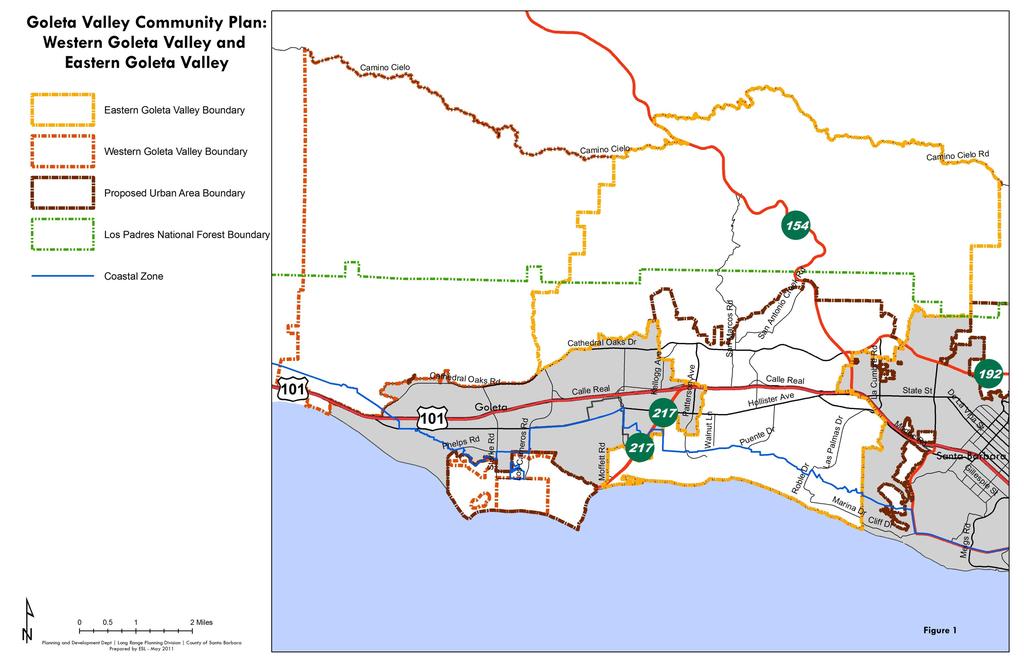
6 LIST OF FIGURES # Title Type Page Figure 1 : Western and Eastern Goleta Valley Map ix Figure 2 : Environmental Stewardship in Sustainable Community Planning Diagram 5 Figure 3 : Community Plan Policy Framework Diagram 7 Figure 4 : Vicinity Map 17 Figure 5 : Planning Area Boundaries Map 18 Figure 6 : Land Use Designations - Rural Area Map 25 Figure 7 : Land Use Designations- Urban Area Map 27 Figure 8 : Zoning Districts - Rural Area Map 29 Figure 9 : Zoning Districts - Urban Area Map 31 Figure 10 : Buildout Table - Residential Units Table 33 Figure 11 : Buildout Table - Commercial Sq Ft Table 33 Figure 12 : U.S. Census Population Trends Table 33 Figure 13 : More Mesa Map 42 Figure 14 : St. Vincent's Map 48 Figure 15 : Urban Agriculture Map 56 Figure 16 : Parks, Recreation, and Trails (PRT) Map 73 Figure 17 : Circulation Map 93 Figure 18 : Bikeway Classifications Diagram 97 Figure 19 : Transportation Improvements Map 102 Figure 20 Bicycle Improvements Map 103 Figure 21 : Watersheds Map 123 Figure 22 : ESH/RC Overlay Map 129 Figure 23 : Atascadero Creek Greenway Map 131 Figure 24 : Noise Element Map 163 Figure 25 : General Location of Public Scenic Resources Table 168 Figure 26 : Public Vistas, Scenic Local Routes, and Gateways Map 169 : ii Eastern Eastern Goleta Valley Community Plan
7 INDEX OF ABBREVIATIONS ADT Average Daily Trips GPA Goleta Planning Area BAR Board of Architectural Review GVPAC Goleta Valley Planning Advisory Committee C&D Construction and Demolition Waste HWY Highway CDP Coastal Development Permit IVMP Isla Vista Master Plan Caltrans California Department of Transportation LCP Local Coastal Program CEQA California Environmental Quality Act LEED Leadership in Energy and Environmental Design CIP Capital Improvement Program LID Low Impact Development CLUP Coastal Land Use Plan LOS Level-of-Service DR Design Residential Land Use Designation LPNF Los Padres National Forest EDRN Existing Rural Development Neighborhood MTD Metropolitan Transit District EGV Eastern Goleta Valley P&D Planning and Development Department EGVCP Eastern Goleta Valley Community Plan PD Planned Development Land Use Designation EHS Environmental Health Services Department PRT Parks, Recreation, and Trails EIR Environmental Impact Report PW Public Works Department EPA U.S. Environmental Protection Agency RC Riparian Corridor ESH Environmentally Sensitive Habitat RHNA Regional Housing Needs Allocation GCP Goleta Community Plan RTP Regional Transportation Plan GHG Greenhouse gas SBCAG Santa Barbara County Association of Governments GIS Geographic Information System SCS Sustainable Community Strategy GPAC General Planning Advisory Committee UA Urban Agriculture GTIP Goleta Transportation Improvement Plan UST Underground Storage Tank GVCP Goleta Valley Community Plan VMT Vehicle Miles Traveled GVC Goleta Visioning Committee WGV Western Goleta Valley TABLE OF CONTENTS iii
8 ISSUE AREA IDENTIFIERS AND ABBREVIATIONS AQ ECO EGV ENV ES FIRE GEO HA HAZ HYD LUA LUC LUR N POL PRT RRC SF TC VIS WAT WW Air Quality Ecology, Biology, and Habitats Planning Area Boundaries and Permitted Uses General Environmental Resources and Constraints Emergency Services and Facilities Fire Protection Services and Facilities Geology, Topography, and Soils History and Archaeology Hazardous Materials Hydrology, Flooding, Drainage, and Stormwater Runoff Agricultural Land Uses Commercial Land Uses Residential Land Uses Noise Law Enforcement Services and Facilities Parks, Recreation, Trails and Open Space Solid Waste and Resource Recovery General Public Services and Facilities Transportation and Circulation Visual Resources Water Resources and Conservation Wastewater Management iv Eastern Eastern Goleta Valley Community Plan
9 PREFACE In 2008, the County Board of Supervisors initiated an update to the 1993 Goleta Community Plan (GCP) exclusively for Eastern Goleta Valley in the County of Santa Barbara. This action divided the Goleta Community Plan area into two plan areas: the western area and the eastern area. The western area continues to be referred to as the Goleta Community Plan area. The eastern area is known as the Eastern Goleta Valley Community Plan area. The 1993 Goleta Community Plan remains unchanged and in effect for the western area. The eastern area (Eastern Goleta Valley Community Plan area) is now subject to the goals, objectives, policies, development standards, and actions in this Eastern Goleta Valley Community Plan. GOLETA PLANNING AREA: Notable changes have occurred in Eastern Goleta Valley since Some of these changes have resulted in an established, more socially diverse community providing a stronger identity and economic base; others have reinforced the need for community planning to both preserve and enhance the community and avoid the unintended negative effects of piecemeal land use decisions. Since the adoption of the GCP in 1993, the following general changes have occurred, which provide the context and catalyst for a comprehensive update of the plan for Eastern Goleta Valley: In 2002, the City of Goleta incorporated, which removed 5,100 acres of the GPA from County jurisdiction. The City of Goleta area contained a majority of the commercially and industrially designated properties as well as Old Town Goleta. The 7,200-acre San Marcos Foothills area located northeast of State Route 154 was added to the Eastern Goleta Valley Community Plan area by the Board of Supervisors for consideration in the update of the plan for Eastern Goleta Valley. Of this inclusion, approximately 200 acres are publicly owned by the County as recreational open space as a result of the Preserve at San Marcos residential development project. The 1993 GCP is largely built out under existing land use designations and does not reflect current objectives for sustainable community development. The importance of thriving small businesses, enterprises, local services, farms, mixed-use commercial development and character, and sustainable economic development has become increasingly apparent from input provided by business owners and residents. Agriculture in the Urban Area has begun to diversify to accommodate economic conditions in the industry, while agriculture in the Rural Area remains an established local industry. PREFACE v
10 Strong local interests in resource conservation and sustainable development have reinforced the need for comprehensive policies to change the manner in which the built environment is designed and developed over the long term. Land use and transportation planning patterns to actively reduce local contributions of greenhouses gases, which promote global warming, have become priorities to all general and comprehensive plans in California. The State of California passed legislation requiring general plans provide for residential and commercial development that is low-impact, minimizes greenhouse gases, and coordinates with transportation planning to create sustainable communities and reduce both the number of trips generated and the vehicle miles traveled by residents and commuters. Innovative planning, analysis, and visualization tools are available to the County to better implement community land use goals and policies, such as geographic information systems (GIS), mixed-use zoning code, and design guidelines. These tools guide land use and development decisions to better achieve sustainable development goals for the community. In response to the changes identified above, the County initiated an update to the 1993 GCP in The process of revising the community plan for Eastern Goleta Valley and its adoption by the Board of Supervisors includes the following steps: 1. Review of a Draft Plan by the community 2. Public hearings before the Planning Commission and the Board of Supervisors to initiate environmental review for the Draft Plan 3. Preparation and public review of a Program Environmental Review Impact Report 4. Adoption of the Eastern Goleta Valley Community Plan vi Eastern Eastern Goleta Valley Community Plan
11 HOW TO USE THE EASTERN GOLETA VALLEY COMMUNITY PLAN Figure 1 delineates the extent of Eastern Goleta Valley and the Goleta Community Plan area (or Western Goleta Valley ). Planners, decision-makers, and community members should refer to either the 2015 Eastern Goleta Valley Community Plan or the 1993 GCP based on the geographic location of interest. The 1993 GCP continues to provide policy and planning direction for the western area. The western area includes the rural lands between the Eastern Goleta Valley Community Plan area and the Gaviota Coast Plan area, two small remainder parcels formerly part of the Ocean Meadows Golf Course, two wetland parcels between UCSB and the Santa Barbara Airport, and Isla Vista. (Note, the 1993 GCP will be superseded in Isla Vista upon certification of the Isla Vista Master Plan by the California Coastal Commission.) PREFACE vii
12 THIS PAGE INTENTIONALLY LEFT BLANK. viii Eastern Eastern Goleta Valley Community Plan
13
14 THIS PAGE INTENTIONALLY LEFT BLANK.
Goleta Valley Community Plan
 Goleta Valley Community Plan Initiation for board of supervisors review Part I - Eastern Goleta Valley Part II - Western Goleta Valley FEBRUARY 1, 2012* *Replaces June 1, 2011 Initiation for County Planning
GVPAC Endorsement of Draft Plan
 GVPAC Endorsement of Draft Plan Tuesday, July 5, 2011 at 6:00PM Call to Order Pledge of Allegiance and Roll Call Public Comment Period Administrative Announcements and Staff Updates Action Minutes from
SAN RAFAEL GENERAL PLAN 2040 INTRODUCTION AND OVERVIEW
 SAN RAFAEL GENERAL PLAN 2040 INTRODUCTION AND OVERVIEW Steering Committee Presentation February 14, 2018 Purpose of General Plan Guide land use and development decisions Coordinate transportation, infrastructure,
This page intentionally blank.
 This page intentionally blank. Parks, Recreation, and Open Space Chapter Relationship to Vision Vision Parks, Recreation and Open Space Chapter Concepts County Government. County government that is accountable
INTRODUCTION. 1.1 What is a General Plan? 1.2 Requirements for a General Plan. 1.3 Introduction to Monterey County
 1.1 What is a General Plan? INTRODUCTION California state law requires each city and county to adopt a comprehensive, long-term general plan for the physical development of the county or city, and any
SANTA BARBARA COUNTY ZONING ADMINISTRATOR STAFF REPORT February 5, 2016
 SANTA BARBARA COUNTY ZONING ADMINISTRATOR STAFF REPORT February 5, 2016 PROJECT NAME: Public Works Isla Vista Sidewalk Improvements & Tree Replacement HEARING DATE: February 22, 2016 STAFF / PHONE: J.
Goleta Community Plan Update
 Goleta Community Plan Update Ecology, Biology, and Habitats GVPAC Meeting Agenda [Wednesday, December 17, 2008, 6:00PM] Pledge of Allegiance and Roll Call Public Comment Period Administrative December
SOUTHEAST AREA SPECIFIC PLAN. Planning Commission Study Session August 18, 2016
 SOUTHEAST AREA SPECIFIC PLAN Planning Commission Study Session August 18, 2016 Background: How did we get here? Directed by City Council to prepare Specific Plan (2012) Sustainability focused grant from
1.0 Circulation Element
 5/9/18 1.0 Circulation Element 1.1 Introduction As growth and development occur in Apache County, enhancements to its circulation system will be necessary. With time, more roads will be paved and air and
Niagara Region Official Plan. Table of Contents
 Niagara Region Official Plan Table of Contents This page has been intentionally left blank. Table of Contents ii Niagara Region Official Plan Niagara Region Official Plan - Table of Contents Chapter 1
SANTA BARBARA COUNTY PLANNING COMMISSION Coastal Zone Staff Report for Highway 101: Carpinteria to Santa Barbara Local Coastal Program Amendment
 SANTA BARBARA COUNTY PLANNING COMMISSION Coastal Zone Staff Report for Highway 101: Carpinteria to Santa Barbara Local Coastal Program Amendment Hearing Date: May 2, 2018 Staff Report Date: April 12, 2018
Subregion I. Proposed Sectional Map Amendment, August Preliminary Master Plan and
 Subregion I Preliminary Master Plan and Proposed Sectional Map Amendment, August 2007 The Maryland-National Capital Park and Planning Commission www.mncppc.org/pgco Abstract TITLE: AUTHOR: SUBJECT: Preliminary
A BLUEPRINT FOR BROCKTON A CITY-WIDE COMPREHENSIVE PLAN
 A BLUEPRINT FOR BROCKTON A CITY-WIDE COMPREHENSIVE PLAN Public Meeting October 2016 1 Plan Summary and Discussion Public Meeting May 4 2017 City of Brockton Bill Carpenter, Mayor Department of Planning
GENERAL PLAN AND ENVIRONMENTAL IMPACT REPORT
 City of Menifee HEARING DRAFT GENERAL PLAN AND ENVIRONMENTAL IMPACT REPORT City Council November 2013 PURPOSE OF MEETING Overview of GP Process Overview of required and optional GP elements Receive direction
Public Review Draft Oceanside Subarea Habitat Conservation Plan/ Natural Communities Conservation Plan
 Oceanside Subarea Habitat Conservation Plan/ Natural Communities Conservation Plan Prepared for City of Oceanside Planning Department 300 N. Coast Highway Oceanside, CA 92054 Prepared by Ogden Environmental
MEMORANDUM. A. Small Scale Campgrounds Recreational Vehicle (RV) Size Limits
 Size Limits") COUNTY OF SANTA BARBARA PLANNING AND DEVELOPMENT MEMORANDUM TO: FROM: Santa Barbara County Planning Commission Mindy Fogg, Interim Deputy Director Long Range Planning Division DATE: September 7, 2016 RE:
COUNTY OF SANTA BARBARA PLANNING AND DEVELOPMENT MEMORANDUM TO: FROM: Santa Barbara County Planning Commission Mindy Fogg, Interim Deputy Director Long Range Planning Division DATE: September 7, 2016 RE:
Preliminary Port Towns Sector Plan and Proposed Sectional Map Amendment March 2009
 Preliminary Port Towns Sector Plan and Proposed Sectional Map Amendment March 2009 BLADENSBURG u COLMAR MANOR u COTTAGE CITY u EDMONSTON The Maryland-National Capital Park and Planning Commission Prince
VILLAGE & TOWN OF BERGEN: COMPREHENSIVE PLAN
 VILLAGE & TOWN OF BERGEN: COMPREHENSIVE PLAN CPC Public Hearing April 21, 2016 History 1996 Comprehensive Plan Comprehensive Plan Update Committee Consultant (LaBella Associates): December 2014 Residents
I. DESCRIPTION OF PROPOSED ACTION... 1 A. General Description... 1 B. Historical Resume and Project Status... 2 C. Cost Estimates...
 PROJECT COMMITMENTS SUMMARY... S-1 1. Type of Action... S-1 2. Description of Action... S-1 3. Summary of Purpose and Need... S-1 4. Alternatives Considered... S-2 5. NCDOT Alternatives Carried Forward...
HOT SPRINGS COMPREHENSIVE PLAN OUTLINE
 HOT SPRINGS COMPREHENSIVE PLAN OUTLINE 7/28/2015 Draft outline - Hot Springs Comprehensive Plan Draft outline of topics to be discussed at public hearings and in planning sessions. Order and topics and
Table of Contents TABLE OF CONTENTS SECTION TITLE PAGE
 TABLE OF CONTENTS SECTION TITLE PAGE 1 INTRODUCTION AND OVERVIEW 1-1 1.1 Purpose and Need 1-1 1.2 Goals and Objectives 1-3 1.3 Overview of the Planning Process 1-5 1.4 Federal and State Requirements and
This chapter describes the purpose of the Plan, introduces how the Plan is organized and provides contextual background for the Plan.
 Chapter 1: INTRODUCTION Purpose of a Comprehensive Plan The 2040 Comprehensive Plan establishes Medina s vision as a community and sets goals and objectives which guide future decisions and policies. The
MARIN COUNTY PLANNING COMMISSION WORKSHOP MINUTES March 8, 2004 Marin County Civic Center, Room #328 - San Rafael, California
 MARIN COUNTY PLANNING COMMISSION WORKSHOP MINUTES March 8, 2004 Marin County Civic Center, Room #328 - San Rafael, California Commissioners Present: Commissioners Absent: Allan Berland, Chairman Steve
open public hearing and allow public comment request to continue LPA public hearing to January 16, 2014 at 10:30 am
 TODAY S AGENDA Work Session LPA Transmittal Public Hearing open public hearing and allow public comment request to continue LPA public hearing to January 16, 2014 at 10:30 am staff will issue a recommendation
HALF MOON BAY LOCAL COASTAL PROGRAM. d), JOHN M. St>NGER ASSOCIATES INC S.F.' CA EIOO VISUAL RESOURCES OVERLAY.
, JOHN M. St>NGER ASSOCIATES INC S.F.' CA EIOO VISUAL RESOURCES OVERLAY.") VISUAL RESOURCES OVERLAY Old Downtown Jl&& Scenic Hillsides Ocean Views from Highway 1 HALF MOON BAY LOCAL COASTAL PROGRAM d), JOHN M. St>NGER ASSOCIATES INC S.F.' CA. 94114 EIOO 217 CHAPTER 7: VISUAL
VISUAL RESOURCES OVERLAY Old Downtown Jl&& Scenic Hillsides Ocean Views from Highway 1 HALF MOON BAY LOCAL COASTAL PROGRAM d), JOHN M. St>NGER ASSOCIATES INC S.F.' CA. 94114 EIOO 217 CHAPTER 7: VISUAL
EASTERN GOLETA VALLEY COMMUNITY PLAN
 C. RESIDENTIAL LAND USES Eastern Goleta Valley is largely suburban residential in character, providing a range of residential types, including single family, condominium, apartment and mobile home types
Warren County/Bowling Green Focus 2030 Comprehensive Plan VOLUME 1 INDEX
 Appendix 5: Index VOLUME 1 INDEX A Aesthetics ES-6, FLU-15, FLU-17, FLU-24, NCR-7 Agricultural Base FLU-18, FLU-20 Agricultural Centers, Rural FLU-11 Agricultural District NCR-17-NCR-18 Agricultural Economy
Authority of the General Plan
 Authority of the General Plan This La Habra Heights General Plan will serve as the blueprint for future planning and development in the City. This General Plan describes the City s vision for the future
PLANNING AND NATURAL RESOURCES COMMITTEE. Public Access Conceptual Design Alternatives for the Red Barn Area of La Honda Creek Open Space Preserve
 PLANNING AND NATURAL RESOURCES COMMITTEE R-17-56 May 9, 2017 AGENDA ITEM AGENDA ITEM 2 Public Access Conceptual Design Alternatives for the Red Barn Area of La Honda Creek Open Space Preserve GENERAL MANAGER
Chapter 5: Recreation
 Chapter 5: Recreation Introduction and Setting Recreational opportunities within Nevada County are varied, ranging from public parks with intensively used active recreational facilities, to vast tracts
COLVER ROAD INDUSTRIAL CONCEPT PLAN
 COLVER ROAD INDUSTRIAL CONCEPT PLAN A CONCEPTUAL LAND USE AND TRANSPORTATION PLAN FOR TA-4 AN URBAN RESERVE AREA OF THE CITY TALENT City of Talent Adopted by City Council Resolution No., June, 2015 PART
3. VISION AND GOALS. Vision Statement. Goals, Objectives and Policies
 Vision Statement Queen Creek s interconnected network of parks, trails, open spaces and recreation opportunities provide safe and diverse activities and programs that sustain its unique, small town, equestrian
IMPLEMENTING SOMERSET COUNTY S INVESTMENT FRAMEWORK
 IMPLEMENTING SOMERSET COUNTY S INVESTMENT FRAMEWORK SMART CONSERVATION THROUGH SMART GROWTH NJ LAND CONSERVATION RALLY March 22, 2014 Laurette Kratina, PP, AICP, Supervising Planner Somerset County Planning
TABLE OF CONTENTS PAGE
 1989 BROWARD COUNTY LAND USE PLAN Original adoption March 1, 1989 Text amendments adopted as of March 10, 2015, are incorporated herein. BROWARD COUNTY BOARD OF COUNTY COMMISSIONERS BROWARD COUNTY PLANNING
Project Team. 2M Associates. City of Saratoga. HT Harvey Biology. PlaceWorks. NV5 Infrastructure. Tom Origer Associates History/Archeology
 Project Team City of Saratoga John Cherbone, Director of Public Works Iveta Harvancik, Senior Engineer PlaceWorks Isabelle Minn, Principal-in-Charge Isby Fleischmann, Project Manager Kyle Simpson, CEQA
Natomas Joint Vision Open Space Plan
 Natomas Joint Vision Open Space Plan First Workshop series The City of Sacramento The County of Sacramento LAFCo ERA Economic Research Associates EIP Associates a Division of PBS & J Natomas Joint Vision
Community Development Department Planning Division 1600 First Street + P.O. Box 660 Napa, CA (707)
") Community Development Department Planning Division 1600 First Street + P.O. Box 660 Napa, CA 94559-0660 (707) 257-9530 PLANNING COMMISSION STAFFREPORT December 4, 2014 AGENDA ITEM 8.A. 14-0138; ALTAMURA
Community Development Department Planning Division 1600 First Street + P.O. Box 660 Napa, CA 94559-0660 (707) 257-9530 PLANNING COMMISSION STAFFREPORT December 4, 2014 AGENDA ITEM 8.A. 14-0138; ALTAMURA
Regional Context Statement
 Regional Context Statement REGIONAL CONTEXT STATEMENT 3. REGIONAL CONTEXT STATEMENT In 1995, the Provincial Government passed into law the Growth Strategies Act. The purpose of this provincial initiative
Department of Community Development. Planning and Environmental Review Division Revised Notice of Preparation
 Department of Community Development Michael J. Penrose, Acting Director Divisions Building Permits & Inspection Code Enforcement County Engineering Economic Development & Marketing Planning & Environmental
Office of Greenways & Trails Providing Statewide Leadership and Coordination. Southeast Greenways and Trails Summit October 1-3, 2017
 Office of Greenways & Trails Providing Statewide Leadership and Coordination Southeast Greenways and Trails Summit October 1-3, 2017 1 Office of Greenways and Trails The Office of Greenways and Trails
URBAN DESIGN GOALS / POLICIES / MEASURES
 URBAN DESIGN GOALS / POLICIES / MEASURES GOALS / POLICIES Authority Consideration of urban design issues in the general plan is provided under the Land Use Element requirements which direct attention to
Regional Open Space Conservation Plan. Regional Staff Committee January 18, 2018
 Regional Open Space Conservation Plan Regional Staff Committee January 18, 2018 Schedule We are here Task 1 - Stakeholder Input & Work Plan Dev. v z 2016 2017 2018 Oct Nov Dec Jan Feb Mar Apr May Jun Jul
AMENDMENT NO. 30 TO THE OFFICIAL PLAN OF THE TOWN OF MILTON
 AMENDMENT NO. 30 TO THE OFFICIAL PLAN OF THE TOWN OF MILTON Subject: Boyne Survey Secondary Plan and Related Official Plan Amendments The following text and schedules constitute Amendment No. 30 to the
AWH REPORT OF THE PLANNING AND DEVELOPMENT DEPARTMENT FOR APPLICATION FOR REZONING ORDINANCE TO PLANNED UNIT DEVELOPMENT
 AWH REPORT OF THE PLANNING AND DEVELOPMENT DEPARTMENT FOR APPLICATION FOR REZONING ORDINANCE TO PLANNED UNIT DEVELOPMENT MAY 8, 2014 The Planning and Development Department hereby forwards to the Planning
DOMINION BOULEVARD CORRIDOR STUDY AND ECONOMIC DEVELOPMENT STRATEGIC PLAN A MODEL FOR CHESAPEAKE S FUTURE
 DOMINION BOULEVARD CORRIDOR STUDY AND ECONOMIC DEVELOPMENT STRATEGIC PLAN A MODEL FOR CHESAPEAKE S FUTURE Overview I. Draft Plan Process II. Draft Plan Overview a. Market Analysis b. Master Land Use Plan
THREE-STEP DESIGN PROCESS FOR OPEN SPACE SUBDIVISIONS
 00216106.DOC NMA/RRK 1/30/14 THREE-STEP DESIGN PROCESS FOR OPEN SPACE SUBDIVISIONS Open space subdivisions, sometimes called cluster developments, maintain a significant portion of a development site in
EXECUTIVE SUMMARY. Introduction
 EXECUTIVE SUMMARY Introduction State Route 68 is a designated scenic route that connects the world-renowned Monterey Peninsula to US Highway 101 and the Salinas Valley. SR 68 is a key route for bicycle,
Green Infrastructure Policies and Ordinances
 Green Infrastructure Policies and Ordinances October 23, 2013 By Karen Firehock, Green Infrastructure Center 2013 Georgia Urban Forest Council s 23 rd Annual Conference The mission of the nonprofit Green
Gloucester County s Comprehensive Plan. The Community Connection
 Gloucester County s Comprehensive Plan The Community Connection Current Comp Plan Adopted in 1991 with a 20 year planning horizon Updated in 1995 with Part V- Implementation Recommendations and Appendix
Introduction and Overview
 Introduction and Overview Articulate local values and priorities Guide land use and development decisions Coordinate transportation, infrastructure, and City services with expected growth and available
General Location Annex, Rezone & Preliminary Plat Lansdowne Addition, Unit Three
 NEWFOUNDLAND I-5 Agricultural District Subject Site SUNDANCE ANDERSON Single Family Residential CHRISTY PUD Agricultural District Highway Business General Location Annex, Rezone & Preliminary Plat Lansdowne
Implementation Guide Comprehensive Plan City of Allen
 Implementation Guide 2030 Comprehensive Plan City of Allen DRAFT 2015 Implementation Guide Allen 2030 Comprehensive Plan INTRODUCTION The Comprehensive Plan serves as a guide for the growth and development
3.10 LAND USE SETTING PROJECT SITE EXISTING LAND USE DESIGNATIONS AND ZONING. General Plan Land Use Designations.
 This section of the Draft EIR addresses the existing land uses on and adjacent to the project site and discusses the potential impacts of the proposed project on existing land uses. Key issues addressed
PARK PLANNING & STEWARDSHIP DIVISION
 MCPB Item # July 30, 2015 MEMORANDUM July 23, 2015 TO: Montgomery County Planning Board VIA: FROM: Mike Riley, Director of Parks Mitra Pedoeem, Acting Deputy Director of Parks John E. Hench, Ph.D., Chief,
CHAPTER 10-D GREATER MONTEREY PENINSULA AREA PLAN
 CHAPTER 10-D GREATER MONTEREY PENINSULA AREA PLAN GREATER MONTEREY PENINSULA AREA PLAN SUPPLEMENTAL POLICIES 1.0 - Land Use GMP-1.1 GMP-1.2 GMP-1.3 GMP-1.4 GMP-1.5 GMP-1.6 GMP-1.7 The County shall overlay
-MENDOCINO COUNTY PLANNING AND BUILDING SERVICES- DIVISION II OF TITLE 20--COASTAL ZONING CODE
 CHAPTER 20.504 VISUAL RESOURCE AND SPECIAL TREATMENT AREAS Sec. 20.504.005 Applicability. Sec. 20.504.010 Purpose. Sec. 20.504.015 Highly Scenic Areas. Sec. 20.504.020 Special Communities and Neighborhoods.
MacDonnell Heights Town Center
 Draft Environmental Impact Statement MacDonnell Heights Town Center Town of Poughkeepsie, Dutchess County, New York LEAD AGENCY Town of Poughkeepsie Planning Board One Overocker Road Poughkeepsie, NY 12603
MAYFIELD WEST SECONDARY PLAN PHASE 2
 MAYFIELD WEST SECONDARY PLAN PHASE 2 Public Open House #3 February 25, 2010 Draft Preferred Land Use Scenario TOWN OF CALEDON PLANNING & DEVELOPMENT DEPARTMENT Open House Agenda TOWN OF CALEDON 1. Welcome
2. INTRODUCTION 2.1 AUTHORITY 2.2 PURPOSE AND INTENT 2.3 SITE LOCATION
 2. INTRODUCTION 2.1 AUTHORITY The City of Gardena initiated and prepared the Artesia Corridor Specific Plan pursuant to the provisions of California Government Code, Title 7, Division 1, Chapter 3, Article
KALAMAZOO METROPOLITAN COUNTY PLANNING COMMISSION (KMCPC)
") KMCPC Members: Neil Sikora - Chair, Vince Carahaly Vice Chair, Martin Janssen Secretary, John Gisler (Tracy Hall) - Commissioner Liaisons, Joel Amos, Charles Alexander, Sandra Bliesener, Steven Cook, Heather
KMCPC Members: Neil Sikora - Chair, Vince Carahaly Vice Chair, Martin Janssen Secretary, John Gisler (Tracy Hall) - Commissioner Liaisons, Joel Amos, Charles Alexander, Sandra Bliesener, Steven Cook, Heather
Subject: City of Richfield Cedar Avenue Corridor Plan Comprehensive Plan Amendment, Review File No
 Committee Report Business Item No. 2017-21 Community Development Committee For the Metropolitan Council meeting of January 25, 2017 Subject: City of Richfield Cedar Avenue Corridor Plan Comprehensive Plan
TABLE OF CONTENTS. Transportation Chapter 1 - Introduction and Purpose of Planning to 1-3. Utilities
 Chapter 1 - Introduction and Purpose of Planning... 1-1 to 1-3 Pennsylvania Municipalities Planning Code (Act 247)...1-1 Previous County Planning Activities...1-1 Objectives of the Plan...1-2 Elements
Glenborough at Easton Land Use Master Plan
 Implementation 114 9.0 IMPLEMENTATION 9.1 OVERVIEW This chapter summarizes the administrative procedures necessary to implement the proposed land use plan, infrastructure improvements, development standards,
ENVIRONMENTAL IMPACT REPORT COMPREHENSIVE GENERAL PLAN AND ZONING ORDINANCE SCH NUMBER:
 ENVIRONMENTAL IMPACT REPORT FOR THE CITY OF BANNING COMPREHENSIVE GENERAL PLAN AND ZONING ORDINANCE SCH NUMBER: 2005011039 Prepared for: City of Banning 99 East Ramsey Street Banning, CA 92220 Prepared
THE CORPORATION OF THE CITY OF WINDSOR Office of the City Solicitor Planning Department
 THE CORPORATION OF THE CITY OF WINDSOR Office of the City Solicitor Planning Department REPORT TO THE CITY OF WINDSOR PLANNING ADVISORY COMMITTEE DATE OF REPORT: August 19, 2010 SUBJECT: Official Plan
SECTION 1 Introduction...1. SECTION 2 Regional Context Criteria for Planning Districts Description of Planning District...
 Table of Contents SECTION 1 Introduction...1 SECTION 2 Regional Context...2 2.1 - Criteria for Planning Districts...2 2.2 - Description of Planning District...2 SECTION 3 Goals & Objectives...5 SECTION
World Heritage Cultural Landscapes
 International Expert Workshop on Integrity & Authenticity of World Heritage Cultural Landscapes Dec 11, 2007 - Dec 12, 2007 Aranjuez, Spain Patricia M. O Donnell, FASLA, AICP, IFLA, ICOMOS Heritage Landscapes,
Laberge Group. Town of Coeymans. Draft Comprehensive Plan. Overview of Planning Process
 Draft : Presentation of Goals & Strategies Laberge Group Benjamin H. Syden, A.I.C.P., E.D.P Director in Charge Nicole Allen, A.I.C.P. Senior Planner Anjali Malhotra Planner Presentation Outline Introductions
STEWARDSHIP OF LONG ISLAND SOUND S ECOLOGICAL AND RECREATIONAL RESOURCES
 STEWARDSHIP OF LONG ISLAND SOUND S ECOLOGICAL AND RECREATIONAL RESOURCES Robin Kriesberg, Save the Sound, Inc. Thomas Halavik, US Fish and Wildlife Service Coastal Program An Initiative to Identify, Protect
County of San Diego Comprehensive General Plan Update and Draft EIR Response LOG No. 02-ZA-001; SCH NO
 Development Services Tel: 760.744.1050 1 Civic Center Drive Fax: 760.591.4135 San Marcos, CA 92069-2918 Web: www.san-marcos.net Mr. Devon Muto Department of Planning and Land Use 5201 Ruffin Road, Suite
SECTION 5 - SCENIC HIGHWAYS
 SECTION 5 - SCENIC HIGHWAYS INTRODUCTION The California State Scenic Highways Program was established by the State Legislature through Senate Bill No. 1467 (Farr) in 1963. This Bill established the Scenic
The Maryland-National Capital Park and Planning Commission
 Approved BOWIE Master Plan & Sectional Map Amendment and VICINITY The Maryland-National Capital Park and Planning Commission www.mncppc.org/pgco Abstract Title Author Subject Approved Master Plan for Bowie
2 PLANNING AREA DESCRIPTION
 2 PLANNING AREA DESCRIPTION 2.1 LOCATION Hecker Pass is located within the City of Gilroy near the western city limit. Figure 2-1 illustrates the regional location of the Hecker Pass Area. Figure 2-1:
3.10 Land Use and Planning
 3.10 This section describes the regulatory and environmental setting for land use and planning in the program and individual project areas. It also describes impacts on land use and planning that could
LOS ANGELES CITY PLANNING DEPARTMENT STAFF REPORT
 LOS ANGELES CITY PLANNING DEPARTMENT STAFF REPORT LOS ANGELES CITY PLANNING COMMISSION CASE NO: CPC 2006-9374 CRA CEQA: Exempt DATE: December 21, 2006 Location: Valley Plaza and Laurel Plaza TIME: after
Venice Pumping Plant Dual Force Main Project Draft EIR
 City of Los Angeles 5.9 LAND USE PLANS 5.9.1 Environmental Setting Venice Pumping Plant Dual Force Main Project Draft EIR The Project lies within the bounds of Los Angeles County and the City of Los Angeles.
Kim DeLaney, Ph.D. Strategic Development Coordinator. Overview & Project Approach. Prepared by TCRPC (1/8/2014) 1
 1") Kim DeLaney, Ph.D. Strategic Development Coordinator Waterways Forum #2: Land Use & Upland Transportation Treasure Coast Regional Planning Council January 8, 2014 120+ Miles of Waterways St. Lucie County
Kim DeLaney, Ph.D. Strategic Development Coordinator Waterways Forum #2: Land Use & Upland Transportation Treasure Coast Regional Planning Council January 8, 2014 120+ Miles of Waterways St. Lucie County
CHAPTER 2 SUMMARY 1. PROJECT SUMMARY DATA
 CHAPTER 2 SUMMARY This is an Initial Study format used to determine, pursuant to CEQA Guidelines Section 15177, whether a project 1) is within the scope of a Master EIR (MEIR), 2) may result in additional
ARROYO PROJECTS ADOPTED CAPITAL IMPROVEMENT PROGRAM BUDGET
 A RROYO P ROJECTS ADOPTED CAPITAL IMPROVEMENT PROGRAM BUDGET FISCAL YEARS 214-218 HAHAMONGNA Priority Description 1 Hahamongna Watershed Park - Implement Master Plan 211,6 211,6 (77565) 2 Hahamongna -
III. PROJECT DESCRIPTION
 III. PROJECT DESCRIPTION A. PROJECT LOCATION Regional Setting The project site is located in the southeast quadrant of the City of Chico in Butte County, California and is comprised of four parcels totaling
4-Town Comprehensive Plan DRAFT 7/30/07
 4-Town Comprehensive Plan DRAFT 7/30/07 Acknowledgements ning Committee Town of Harrisburg Norman Roof Randy Nicol Town of Martinsburg Terry Thisse Paul Kelly Town of Montague Jan Bagdanowicz Wendy Perry
MONTGOMERY COUNTY PLANNING DEPARTMENT
 MONTGOMERY COUNTY PLANNING DEPARTMENT THE MARYLAND-NATIONAL CAPITAL PARK AND PLANNING COMMISSION Ashburton Elementary School Addition, Mandatory Referral, MR2018009 MCPB Item No. Date: 02-15-18 Troy Leftwich,
GIS to Estimate Archaeological Site Loss and Develop Conservation Strategies
 GIS to Estimate Archaeological Site Loss and Develop Conservation Strategies Terry Jackson Office of Decision Support Systems Planning and Environmental Management Division Georgia Department of Community
LAND USE ELEMENT. Purpose. General Goals & Policies
 LAND USE ELEMENT Purpose This Land Use Element contains the goals and policies necessary to support the City s responsibility for managing land resources and guiding development through implementing regulations,
Cumberland Comprehensive Plan Town Council adopted August 2003, State adopted June 2004 TABLE OF CONTENTS
 TABLE OF CONTENTS I. Executive Summary A. Scope of the Comprehensive Plan I-2 B. Plan Development Process I-3 C. Plan Format I-3 D. Acknowledgements I-4 II. Demographic Analysis A. Introduction II-1 B.
2010 Plan of Conservation and Development
 2010 Plan of Conservation and Development Wilton Planning and Zoning Commission Adopted November 2, 2009 Effective January 1, 2010 WILTON 2010 PLAN OF CONSERVATION & DEVELOPMENT PARTICIPANTS Planning &
1.0 REQUEST. MONTECITO PLANNING COMMISSION Staff Report for Danielson Vesting Tentative Parcel Map No. 14,686. Project Site
 MONTECITO PLANNING COMMISSION Staff Report for Danielson Vesting Tentative Parcel Map No. 14,686 Deputy Director: Dave Ward Staff Report Date: February 29, 2008 Division: Development Review Staff Contact:
Making the Land Use, Transportation, Air Quality Connection
 Special Thanks To Our Generous Sponsor What Happened To Harbor Drive and the Mt. Hood Freeway? Andy Cotugno Metro Policy Advisor 180 days of air quality violations Gas Crisis Making The Pacific the Land
Town of Washington Master Plan & Regulatory Audit: Interim Results
 Town of Washington Master Plan & Regulatory Audit: Interim Results May 20, 2008 Presented by: 30 Bank Street Lebanon, NH 03766 www.uvlsrpc.org Introduction & Purpose Compare the Master Plan to the regulations
Chapter 5: Natural Resources and Environment
 NATURAL RESOURCES AND ENVIRONMENT 5-1 5 Chapter 5: Natural Resources and Environment BACKGROUND AND INTENT Urban expansion represents the greatest risk for the future degradation of existing natural areas,
Joint Study Session of the Sutter County. March 2, 2009
 Joint Study Session of the Sutter County Board of Supervisors and Planning Commission March 2, 2009 CURRENT APPLICATION General Plan Amendment Specific Plan Specific Plan Appendices Utility Plans Transit/AQ
NOTICE OF PREPARATION
 NOTICE OF PREPARATION DATE: April 6, 2017 TO: FROM: Responsible Agencies Trustee Agencies Local and Public Agencies Interested Parties Contact: Brent Cooper, AICP, Community Development Director 4381 Broadway
COUNTY OF SANTA BARBARA
 COUNTY OF SANTA BARBARA CENTRAL Solvang Municipal Court BOARD OF ARCHITECTURAL REVIEW 1745 Mission Drive, Suite C APPROVED MINUTES Solvang, CA 93463 Meeting Date: September 14, 2018 (805) 934-6250 Bethany
Bressa Developments Limited. Planning Justification Report. Revised Draft Plan of Subdivision and Zoning By-Law Amendment
 Bressa Developments Limited Revised Draft Plan of Subdivision and Zoning By-Law Amendment Planning Justification Report Part of Lots 7 & 8 Concession 1, North of Dundas Street Town of Oakville September,
Communities Plan. Parkland-Spanaway-Midland. LUAC Review of Draft Policies
 Parkland-Spanaway-Midland Communities Plan LUAC Review of Draft Policies Presented by: Tiffany O Dell, Senior Planner Planning & Public Works Tiffany.Odell@co.pierce.wa.us 253-798-6859 November 1, 2017
Joint Meeting City Council and the Plan Commission. September 1st, 2015
 Joint Meeting City Council and the Plan Commission September 1st, 2015 1 The City Plan Commission shall recommend a City Plan for the physical development of the City Article IX Section 2 of the City of
CHUGIAK-EAGLE RIVER SITE-SPECIFIC LAND USE PLAN
 CHUGIAK-EAGLE RIVER SITE-SPECIFIC LAND USE PLAN JUNE 2010 Final Prepared for The Heritage Land Bank, Municipality of Anchorage by Agnew: :Beck Consulting www.agnewbeck.com 907.222.5424 Chugiak-Eagle River
RESOLUTION NO
 RESOLUTION NO. 13-35 A RESOLUTION OF THE CITY COUNCIL OF THE CITY OF MALIBU APPROVING GENERAL PLAN AMENDMENT (GPA) NO. 12-001, AMENDMENT TO THE GENERAL PLAN LAND USE ELEMENT AS REQUIRED TO IMPLEMENT THE
CITY COUNCIL Arthur C. Brown Mayor Fred Smith Mayor Pro Tem Patsy Marshall Council Member Don McCay Council Member Jim Dow Council Member
 CITY COUNCIL Arthur C. Brown Mayor Fred Smith Mayor Pro Tem Patsy Marshall Council Member Don McCay Council Member Jim Dow Council Member PLANNING COMMISSION Larry Barstow Brian Chambers Paul Gonzales
Rappahannock- Rapidan Regional Commission
 Rappahannock- Rapidan Regional Commission Last Updated July 2008 RAPPAHANNOCK-RAPIDAN REGIONAL TRANSPORTATION PLAN The Virginia Department of Transportation (VDOT) and the Rappahannock-Rapidan are partnering