PARKS & RECREATION BOARD MISSION STATEMENT
|
|
|
- Paul Cook
- 5 years ago
- Views:
Transcription
 IV. Presentation of Eagle Scouts Service Recognition V.")
1 Parks and Recreation Board Agenda Department of Public Services 851 South Eton-Conference Room Tuesday, January 8, :30 PM I. Call to order II. Roll Call III. Approval of the minutes of: Tuesday, December 4, 2018 (regular meeting) IV. Presentation of Eagle Scouts Service Recognition V. Agenda Items-Written and submitted by 5pm Monday at the Birmingham Ice Sports Arena, one week prior to the meeting. 1) Nomination of 2019 Parks and Recreation Board Chairperson/Vice-Chairperson 2) Museum Landscape Master Plan Update, Leslie Pielack, Museum Director 3) Barnum Park Shade Structures Purchase VI. Communications/Discussion Items 1) Long Range Planning Session, Saturday, January 26, 2019, 151 Martin Street, City Municipal Building, starting at 8:30 AM (verbal) 2) Parks and Recreation Master Plan Capital Project Input Session Tuesday, February 5, 2019 Parks and Recreation Board Meeting (verbal) 3) Electronic Parks & Recreation Board Packets (verbal) VII. Unfinished Business VIII. New Business IX. Open To The Public for Items Not On the Agenda X. Next Regular Meeting Tuesday, February 5, 2019 (DPS) Individuals requiring accommodations, such as interpreter services, for effective participation in this meeting should contact the City Clerk's Office at (248) at least one day in advance of the public meeting. Las personas que requieren alojamiento, tales como servicios de interpretación, la participación efectiva en esta reunión deben ponerse en contacto con la Oficina del Secretario Municipal al (248) por lo menos el día antes de la reunión pública. (Title VI of the Civil Rights Act of 1964). If you cannot attend the meetings, please contact Connie Folk at the Birmingham Ice Arena (248) Minutes are available for review at the Birmingham Ice Sports Arena, 2300 East Lincoln, Birmingham, MI PARKS & RECREATION BOARD MISSION STATEMENT The Parks and Recreation Board strives to provide opportunities for the enjoyment, education, and inspiration for present and future generations of residents and visitors through stewardship of natural, cultural and recreational resources. By continuously elevating the beauty and quality of the parks and recreation system of Birmingham, the Parks and Recreation Board will promote health and wellbeing, and strengthen the community.
2 PARKS AND RECREATION BOARD MEETING MINUTES December 4, 2018 Therese Longe, Chairperson, called the meeting to order at 6:31 p.m. at 851 S. Eton. MEMBERS PRESENT: MEMBERS ABSENT: STUDENT REPRESENTATIVES PRESENT: STUDENT REPRESENTATIVES ABSENT: ADMINISTRATION: GUESTS: Heather Carmona, Ross Kaplan, Therese Longe (arrived at 6:31 pm), Ellie Noble, John Rusche and Bill Wiebrecht John Meehan and Lilly Stotland Jakob Sayers, Seaholm Student CeCe Cousins, Seaholm Student Lauren A. Wood, Director of Public Services Connie J. Folk, Recreation Coordinator David Young Ellie nominated Heather as the chairperson until Therese Longe arrives. Therese Longe arrived at 6:31 pm It was moved by Bill Wiebrecht, seconded by Ross Kaplan that the minutes of the November 13, 2018 regular meeting be approved as amended. Yeas 6 Nays 0 Absent -2 Heather Carmona, Ross Kaplan, Therese Longe, Ellie Noble John Rusche and Bill Wiebrecht John Meehan and Lilly Stotland AGENDA ITEMS No Agenda Items COMMUNICATION/DISCUSSION ITEM #1 Pickleball Review and Tennis Courts Evaluation Connie provided as a follow up from the April 3, 2018 Parks and Recreation Board meeting a report regarding pickleball that was held at the Birmingham Ice Sports Arena and also the usage of the City of Birmingham outdoor tennis courts for the Spring/Summer 2018 season. Connie stated that the pickleball comments which were provided by Chris Braun, Director of NEXT were better lighting and temperature control at the City of Birmingham Ice Sports Arena. Connie stated capital improvements are scheduled for the Birmingham Ice Sports Arena which includes upgrading the lighting to LED s and with the hot temperatures the HVAC units could not keep up. Connie stated that the program was positive and for future programming the times would be reduced based on the play that occurred during the 2018 season.
3 2 Connie stated that the department tracked the usage of tennis reservations that were taken by the office. Connie stated it is not a requirement to reserve the tennis courts but that small groups that use the City of Birmingham tennis courts on a regular basis would receive a permit. Connie stated that she contacted other communities on the cost of existing tennis courts being converted to pickleball courts and also the cost for installation of new pickleball courts. Connie stated that additional information has been requested in costs of from Ann Arbor and the City of Holland. Connie stated that Pembroke and St. James are reserved by a group of ladies/men that have mini tennis matches. Therese asked if the school tennis courts are assessable to the public. Ross Kaplan stated they are as long as they are not being used by coaches or teams. Therese stated that the Parks and Recreation Board would consider installation of new pickleball courts and also converting tennis courts to pickleball courts, both would be considered if a Parks Bond Issue was approved. Therese stated a more accurate study would need to be done before the Parks and Recreation Board could recommend placement of pickleball courts. Therese also stated that other data would need to be gathered such as if the tennis courts are used by the surrounding neighbors that would imply the neighbors walk to the tennis courts and the pickleball ball users would likely be coming from other places like NEXT so available parking would have to be another consideration before the Parks and Recreation Board makes a recommendation of placement of pickleball courts. Therese asked if administration could provide additional information on the breakdown of the cost of the pickleball courts that was provided in the report from the other communities. No action was taken by the Parks and Recreation Board Parks and Recreation Board Meeting 12/4/2018
4 3 COMMUNICATION/DISCUSSION ITEM #2 Update from Master Plan Sub-Committee (verbal) Heather stated that the sub-committee walked along Rouge River Corridor, Lot 6, the Museum and Booth Park to determine priorities from the Museum Plan, Conceptual Plans of Lot 6 in order to determine items that could be prioritize for the bond issue which are existing in the Rouge River Corridor Master Plan. Heather stated the focus was more on the access to the Museum from the Rouge River Corridor. No action was taken by the Parks and Recreation Board COMMUNICATION/DISCUSSION ITEM #3 Bankshot Playcourts, from Joe Valentine, City Manager Connie stated that the information was provided by the City Manager s office and is a communication only. Ellie stated that this type of program would be useful for the schools to look into. No action was taken by the Parks and Recreation Board COMMUNICATION/DISCUSSION ITEM #4 Barnum Park Shade Structures-out for bid (verbal) Lauren stated that Barnum Park Shade Structures is out for bid and a recommendation will return to the Parks and Recreation Board in January, No action was taken by the Parks and Recreation Board COMMUNICATION/DISCUSSION ITEM #5 Nomination of 2019 Parks and Recreation Board Chairperson/Vice-Chairperson Connie stated that nominations for the 2019 Parks and Recreation Board Chairperson/Vice- Chairperson will take place at the Tuesday, January 8, 2019 Parks and Recreation Board meeting. No action was taken by the Parks and Recreation Board UNFINISHED BUSINESS: No unfinished business NEW BUSINESS: No new business OPEN TO THE PUBLIC FOR ITEMS NOT ON THE AGENDA: Therese Longe stated the next regular meeting will be held on Tuesday, January 8, 2019 at 6:30 pm at DPS. Meeting was adjourned at 7:15 pm Connie J. Folk, Recreation Coordinator Parks and Recreation Board Meeting 12/4/2018

5 Memorandum DATE: January 8, 2019 TO: Parks and Recreation Board FROM: Leslie Pielack, Museum Director SUBJECT: Museum Landscape Update Summary In January of 2018, the Parks and Recreation Board and the Historic District Commission met jointly with the Museum Board to discuss the history of the museum site and a landscape master plan concept for preserving and enhancing the grounds as well as providing greater public access. We also gathered public input and met with stakeholders to share the plan and receive feedback. A final Landscape Master Plan was developed as an outgrowth of this process and accepted by the City Commission on March 12, The plan divides the four-acre museum site into four distinct zones, each with preservation objectives for historic or natural features as well as interpretive goals and plans for public access. Project estimates and timelines to accomplish these objectives were incorporated into the final document to guide planning (see attached). In September 2018, the Museum Board held a public open house to invite neighbors and interested members of the community to learn more about the plan and the goals for each zone. Brian Devlin, our historic landscape architectural consultant, was on hand to answer questions and provide graphic sketches to convey the concepts for each zone (see also attached). The event helped us gauge the impact on the immediate neighborhood and support for the plan, which was enthusiastic. Current Plans (2019) The Museum Board is currently working with Mr. Devlin to develop final designs for the Heritage Zone, which encompasses the most visible and accessible part of the landscape around the Allen and Hunter Houses and the public plaza between them. The estimated costs to complete the plan are quite modest; the Museum Board is hopeful that sponsorships and pledges from a special fundraising event will help complete the Heritage Zone construction this year. If the Allen House and landscape are successfully listed (as an individual property) on the National Register of Historic Places later this year (currently in process), that will open the door to additional financial support for some projects and Beyond Following the Heritage Zone, the Museum Board will move forward with the next zone priority, the Pond Zone, which is more ambitious. Final design work and cost estimates can be expected in 2020, with construction anticipated in Because of the unique historical and natural features of that part of the landscape (the unusual spring-fed swimming pool that was used as a polio treatment), sufficient funding is hoped for through effective partnerships and grant support, both private and public. By bringing together various stakeholders, the Museum Board hopes to build momentum to the project and potentially attract new donor sources. These efforts will help guide the approaches for the two remaining zones to complete the entire plan in the coming years. The Museum Board recognizes the importance of collaborating with the Parks and Recreation Board and the city as a whole in coordinating these projects to preserve and enhance our public resources. We look forward to opportunities to work together to accomplish our shared goals in the years ahead. We appreciate your interest and welcome your support as we move forward.

6 2018 Landscape Master Plan Brian Devlin, Nagy Devlin Land Design Leslie Pielack, Birmingham Museum Approved by the Museum Board, 2/20/2018 Accepted by the City Commission, 3/12/2018

7 This Landscape Master Plan for the Birmingham Museum and grounds, a City of Birmingham property, is the result of contributions from a wide range of stakeholders. These include members of the public; the City Commission and other advisory boards and commissions; the Friends of the Birmingham Museum; donors; and city administration and staff. In particular, we would like to acknowledge the following: CITY COMMISSION Andrew Harris, Mayor Patty Bordman, Mayor Pro Tem Pierre Boutros, Commissioner Carroll DeWeese, Commissioner Rackeline Hoff, Commissioner Mark Nickita, Commissioner Stuart Sherman, Commissioner Acknowledgements CITY ADMINISTRATION Joseph A. Valentine, City Manager Leslie Pielack, Museum Director MUSEUM BOARD Tina Krizanic, Chair James Cunningham Russell Dixon Lori Eaton Judith Keefer Marty Logue Caitlin Rosso Carson Claar, Student Representative Hanna Sandler, Student Representative FRIENDS OF THE BIRMINGHAM MUSEUM BOARD Daniel C. Patton, President Fred Amrose George Getschman Marty Logue Leslie Mio Jennifer O Hare Caitlin Rosso Mark Thomas THE ROSSO FAMILY FOUNDATION

8 I. INTRODUCTION 1 II. GOALS AND OBJECTIVES 3 A. Purpose of Plan B. Planning Process III. HISTORIC BACKGROUND 6 IV. SURVEY AND ANALYSIS OF EXISTING CONDITIONS 8 V. PROPOSED LANDSCAPE MASTER PLAN A. General information 13 B. Zones 1. Heritage Zone Transition Zone Riverine/Woodland Zone Pond Zone 20 Table of Contents Table of Contents VI. CAPITAL IMPROVEMENTS AND FUNDING 22 VII. APPENDIX A. Additional Views of Landscape Master Plan B. Comments from Joint Workshop C. Comments from Parks and Recreation Planning Process
9 Page 1 I. Introduction
10 The site of the Birmingham Museum is one of the most historically and topographically complex in the city. It has distinctive natural landscape features on a steeply sloping lot with a rich history from pioneer times to the 20 th century. Its location makes it accessible to both people and haven for a wide range of wildlife, yet it is centrally located in downtown Birmingham. In 2009, a preliminary landscape master plan by Michael Dul & Associates proposed a highly developed site with activity areas, a playground, paved terracing, extensive pathways and gardens, lighting, structures such as an arbor, decorative stone walls, and sculptures. Cost estimates exceeded 1 million dollars; at the time, it was hoped that park bond funds would be available to pay for the plan. However, sufficient park bond funding was not available, and it was not implemented. Dul s plan did provide guidelines for the final design and construction of Americans with Disability Act (ADA)/barrier-free access to the Allen and Hunter Houses in 2010 and These were completed largely with federal Community Development Block Grant (CDBG) funds, which support ADA projects. The Dul plan was preliminary only, and is now incompatible with the direction of recent museum strategic planning. It also does not reflect changes in technology that have occurred since it was proposed. For example, providing public WiFi was not a consideration at that time, but now our digital needs have developed in new ways, making this a key focus of public programming and providing alternative access opportunities. Also, the Rouge Trail Corridor plan was not incorporated into the 2009 plan, although the museum site shares a long boundary with the consistently used area as part of its overall landscape. But most importantly, the Dul plan did not survey the significant historic nature of the site and its existing features, so that no provision could be made for their protection or preservation. In 2016, the Museum Board considered the most appropriate approach for the landscape in the course of reviewing its general Museum Strategic Plan for The Museum Board wished to identify general concepts for the park, determine how phased approaches (such as improvements at the pond) could be utilized, and make additional recommendations. As the park is part of Birmingham s Mill Pond Historic District, the first step was to survey existing historic and natural features of the landscape, to understand and make recommendations to preserve and protect those resources and factor in public education and access in planning. The Friends of the Birmingham Museum and the Rosso Family Foundation provided funding, and Brian Devlin, historic landscape architect of Nagy Devlin Land Designs was selected to study the landscape and make recommendations to the Museum Board before further master planning was undertaken. The Museum Board worked with Mr. Devlin to review his findings and integrate them into a final Landscape Master Plan that is closely aligned with the museum s mission and Birmingham Museum Strategic Plan. It protects and preserves the natural aspects of the landscape, while restoring its unique historic character that has been lost or obscured by invasive plants. Furthermore, the plan integrates a variety of public access options, enhancing the museum s community engagement and educational opportunities. Although flexible and conceptual, it is comprehensive and consistent with the city s other planning initiatives and parks, allowing for coordination of projects. The identified zones also lend themselves very well to project-based funding support through grants or private donations. Page 2

11 II. Goals and Objectives Page 3
12 PURPOSE of PLAN The overall purpose of developing a Landscape Master Plan for the museum site is to provide long term guidance for improvement projects and other planning that incorporates the needs of the public with the existing natural features, the site s history and location in a local historic district, and city initiatives. The Birmingham Museum Landscape Master Plan is compatible with, but separate from, the Birmingham Museum Strategic Plan. It is also aligned with the museum s mission, as stated below: Museum Mission The Birmingham Museum will explore meaningful connections with our past, in order to enrich our community and enhance its character and sustainability. Our mission is to promote understanding of Birmingham's historical and cultural legacy through preservation and interpretation of its ongoing story. Goals and Objectives The specific goals and objectives of the Birmingham Museum Landscape Master Plan are as follows: 1. To Improve public access, especially barrier-free access, to the museum site 2. To preserve the natural and historic landscape features 3. To provide opportunities for education and interpretation of the site, its natural environment and its cultural history 4. To coordinate with the City of Birmingham Parks and Recreation and Rouge River Corridor plans and projects, such as pathways, access priorities, materials, and signage. 5. To utilize phased planning to optimize private donations and grant funding opportunities Planning Process In order to approach the museum landscape planning comprehensively, input was gathered from a wide range of sources. These included: The Museum Board s extensive review of existing conditions, historical materials, site review and survey data through meetings with historical landscape consultant Brian Devlin. Other consultation included Hubble, Roth, and Clark regarding a pond and wetlands survey and associated state regulations and requirements. Input of the city staff from Parks, Engineering, Building, and Planning/Historic Preservation Departments regarding infrastructure, planning, alignment with local historic district ordinance and State Historic Preservation Office guidelines, ADA access and parking issues, and integration/coordination with policies and materials used by other city parks. A joint workshop between the Museum Board, the Parks and Recreation Board, and the Historic District Commission was held on January 17, 2018 to discuss the plan and gather input from board members as well as the public. Ongoing updates during 2016 and 2017 and formal presentation and discussion with the Friends of the Birmingham Museum Board on January 25, Public input was gathered through the joint workshop on January 17, Immediate neighbors were contacted Page 4


13 and invited to attend the workshop. Several were present at the meeting, including a neighbor who shares the east boundary with the Hunter House. Some public data was also gathered through the Parks and Recreation Master Plan s survey process in the fall of Meetings were held and the review process discussed with members of the Michigan Department of Environmental Quality, and DTE Energy planners regarding requirements of the site that involve wetlands regulation and utilities issues to aid in additional planning. The Historic District Commission Design Review Board reviewed and unanimously approved the plan on January 17, The resulting Birmingham Museum Landscape Master Plan is conceptual in nature. While it provides a broad approach to integrating diverse components, it is designed to give general guidance in more detailed future planning. Additional design work will be needed on a project-related or phased basis. Its strength lies in its careful consideration of providing for public needs while maintaining a fundamental preservation focus to ensure that no irreversible changes are made that negatively impact the historic or natural character of the landscape. Page 5

14 III. Historic Background Page 6
15 EARLY SETTLEMENT PERIOD ( ) The landscape of the area that is now downtown Birmingham is characterized by its proximity to the Rouge River, which has formed valleys and has several branches and numerous tributaries as it works its way south through Oakland County to the Detroit River. The Saginaw Trail (now Woodward Avenue) followed the best route through swampy areas northwest out of Detroit. It was the only land route through the area when pioneer settlers came to Michigan in the early 19 th century. Settlers sought to purchase land at locations that had multiple resources, especially water and mill sites. Elijah Willits made claim to one of four parcels that intersected near where the Rouge River crossed the Saginaw Trail in what is now downtown Birmingham. This original purchase of 160 acres includes the site of the Birmingham Museum. The original landscape wilderness was populated by a variety of native plants, trees and woodland wildlife, much of which is still present. Over time, non-native plants have begun to dominate. The museum site includes a portion of the floodplain of the Rouge River valley, as well as a spring-fed pond that drains to the river near Willits Street. Spring seeps also form a wetland environment on the southeast side of the pond. RED SCHOOLHOUSE PERIOD ( ) In , Willits sold a portion of his acreage to the local school district as a site for the first brick schoolhouse in Birmingham. Built of local brick, the red schoolhouse as it is known, was in service until 1869, when the larger Hill School was built. The red schoolhouse was converted to a residence, and by the end of the 19 th century a small barn was built on the property behind the building and near the edge of the slope to the Rouge. Around this time, fieldstone walls were constructed on the property as well. The former schoolhouse continued to serve as a residence until Marion and Harry Allen purchased the property in the mid-1920s. ALLEN HOUSE PERIOD ( ) The Allens attempted to incorporate the schoolhouse into their plans for their new home but were unable to use the entire building, as portions of it collapsed when excavating their basement. However, they re-used the brick and a portion of the school that remained, creating the current version of the Allen House in It is a Colonial Revival style house with prominent red brick and cedar shingle siding, featuring a large front porch and many dormers. The Allens made some changes to the landscape that are documented in photos. These included enhancing the park-like appearance of much of the property with large elm trees and open areas of lawn. The area near the house was planted with perennials and shrubs characteristic of the period. Two years before they built the house, 9 year old Jim Allen was struck with poliomyelitis reportedly the only person in Birmingham to be afflicted. The spring fed pond was partially enclosed with concrete walls to create a swimming pool to help ease Jim s physical symptoms. Photos show the rectangular edges of the enclosure with a spillway to allow water to drain into the pond and on to the Rouge, and a platform and rail that may have led to a stair into the pool. Page 7
16 CITY OWNERSHIP-1969-PRESENT In 1969 voters approved the purchase of the house and land by the city to create a historic park, and to move the Hunter House there to save it from demolition. The Clizbe-Allen family continued to occupy the Allen House until 1973 by agreement with the city. From , the Allen House was renovated through efforts of a bicentennial commission and members of the community, who raised funds in a combination of private donations and grants. As part of the landscape renovation during this time, the pond and pool were a concern because of maintenance needs and crumbling concrete walls. Filling them in and plowing them over was one solution to make way for more extensive landscaping and development, which included a possible arboretum. This concept for the landscape did not materialize, however due to the high cost. Instead, volunteers planted and maintained flower gardens for a number of years at the Hunter and Allen Houses, which depended on volunteer resources and availability. Boy Scout troops helped with clearing old growth and placing wood chips in pathways. Basic maintenance only was provided for the site otherwise. Since then, the museum has expanded its audience and embraced changes in the museum field to incorporate new technology to reach the next generation. At the same time, preserving the historical past as accurately as possible is also of utmost importance. After the recession of 2008/2009, the focus has been primarily on needed maintenance of the two buildings, on preserving and exhibiting the museum collection, and on public engagement. The landscape has always been important, however. The Museum Board is now in a position to direct its resources and attention to responsible and comprehensive planning. This will ensure the essential history and uniqueness of the site are preserved and that future citizens of Birmingham will experience the benefits of this long term strategy. For a number of years, event rentals were used to help raise funds, but were insufficient to make the building self-sustaining. Even so, the Allen House and grounds was a popular site for parties and weddings. Toward the mid to late 1990s, a joint plan between the city and the Birmingham Historical Society emerged to establish an endowment and to turn the house into a professionally staffed museum. The program met its goals and the Allen House, Hunter House, and surrounding park grounds became a city operated public museum in Page 8

17 IV. Survey and Analysis of Existing Conditions Page 9
18 SURVEY AND ANALYSIS OF EXISTING CONDITIONS Natural Resources Two (2) significant natural resources occur on the museum property that substantially contribute to the quality of the overall landscape and offer unique elements for an expanded museum experience. The first is the Riverine Woodland ecosystem which comprises the western portion of the property. This ecosystem includes the Rouge River along the western boundary with a sparse woodland on the steep slopes rising up to the Allen House which sits at the top of the ridge. Plant species comprising the woodland include black walnut, hickory, maple, elm, box elder, cottonwood, mulberry, and catalpa with honeysuckle, privet, barberry, and buckthorn in the understory and grapevine and daylily occurring in the ground layer. Dead trees and limbs occur throughout the ecosystem. Several invasive species also occur in this ecosystem and include common reed (Phragmites australis) near the river, garlic mustard (Allaria petiolata), oriental bittersweet (Celastrus orbiculatus), creeping Charlie (Glechoma hederacea), buckthorn (Rhamnus cathartica), barberry (Berberis thunbergii), and privet (Ligustrum sp.), all occurring on the steep slopes. Two (2) paths meander through the woodland. The primary path enters the woodland near the westerly driveway of the Allen House and runs diagonally to the northwest to the bridge over the Rouge River at Willits Street. The second path enters the woodland at the base of the steep slope behind the Allen House and connects to the primary path at the base of the slope of the Riverine Woodland ecosystem. Both paths consist of wood chips and include timber steps at the steeper sections of the route. Many timber steps are rotting away and need replacement. The second natural feature is the spring-fed pond on the north central property line immediately adjacent to Willits Street. The pond is fed from groundwater seeps on the east side of the pond. The pond is overgrown with common reed (Phragmites australis) and cattails, and has accumulated debris over the years. The outlet for the pond occurs at the northwest point with a small spillway that leads to a catch basin. A wetland ecosystem is associated with the pond as groundwater is near and at the surface creating wetland conditions that, ironically, occur significantly up the slope, particularly in the southeast corner of the pond. The museum property also includes many trees including catalpa, elm, Norway maple, callery pear, Norway spruce, mulberry, European linden, bald cypress, and arborvitae. Historic Resources The historic resources on the property include two (2) fieldstone walls. One wall occurs along the top of the ridge to the west of the Allen House and may have been part of a barn that was originally on the property. Unfortunately, a north section of this wall has been undermined and has fallen down the slope. The other fieldstone wall is located midway down the slope to the north of and between the Allen House and Hunter House. Both walls are made of fieldstone, both containing whole rounded stones and split face stones, characteristic of 19 th c. farms in southeast Michigan. Probably the most unique historic feature on the property is the swimming or bathing pool with cement walls built into the easterly portion of the pond. The pool was used by the Allens son Jim, who was afflicted with polio, for physical therapy. The swimming pool is evident in the 1963 aerial photograph from Oakland County and from early photographs as indicated below. Page 10

19 Early photograph showing the swimming pool in the pond The pool is unique in concept and design as well as history. It originally incorporated the spring as a natural water source and utilized a flow gate at the surface of the western divider to permit natural drainage and continuous flow. A landing with rail provided access into the water, presumably for Jim Allen to use. These unique aspects of the landscape are especially important for preservation and interpretation, and are highly desirable elements that may be eligible for special funding opportunities. The pond has been surveyed and only two (2) partial walls (the north and east corner) of the swimming pool remain. Concrete was discovered at the bottom of the pond which could be one or more collapsed sides of the pool. Aerial photograph showing the swimming pool in the pond (from Oakland County, 1963) Page 11

20 V. Proposed Landscape Master Plan Page 12
 year. Early on, the museum property was divided into several zones with distinct elements and characteristics associated with each. These distinct areas include: 1.")
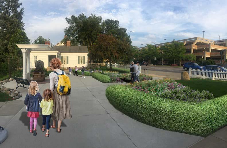
21 GENERAL INFORMATION A conceptual Landscape Master Plan has been prepared and is the result of a collaborative effort of the museum staff, Museum Board, and landscape architectural consultant over a period of about one (1) year. Early on, the museum property was divided into several zones with distinct elements and characteristics associated with each. These distinct areas include: 1. The Heritage Zone along Maple Road with the Allen House, the Bell Plaza, and the Hunter House 2. The Transition Zone immediately north of the houses and plaza 3. The Riverine/ Woodland Zone on the west side of the Allen House to the Rouge River, the westerly boundary of the property; and 4. The Pond Zone which includes the north edge of the property along Willits Street. Each zone and the resulting master plan components are described below. at the Hill School Bell monument. Wi-Fi provides public access opportunities for visitors to the park and the museum. The design objective for this zone was to provide features which could unite these three (3) distinct subzones with minimal impact to historical features while providing opportunities for the community to participate in museum activities. Plan for the Heritage Zone The Master Plan includes restoration of early elm plantings, a children s garden in front of the Hunter House, and a garden of Birmingham heirloom plants at the Hill School Bell Plaza. The early photograph below of the Allen House shows a simple foundation planting with specimen elm trees planted in front of and behind the house. Zone 1: Heritage Zone The Heritage Zone is along Maple Road with the Allen House on the west, the Bell Plaza in the center, and the Hunter House on the east. This section of the museum property has had recent improvements to eliminate the circle drive and provide handicap parking as well as short term parallel parking in front of the Bell Monument. Pedestrian circulation has also been added with a sidewalk along the front and rear of the Allen House, a handicap accessible ramp to the Hunter House, and a plaza and garden area Early photograph showing elm trees in the foreground and background of the Allen House Page 13
22 The Master Plan shows removal of undesirable trees and replacement with modern elm cultivars able to withstand Dutch elm disease. Original planting locations are indicated from recent surveys and a couple of elm stumps are preserved to show the impressive size of these trees. Two (2) new elm cultivars have been planted on either side of the bell monument to replace the diseased elms removed in A children s garden is proposed for the space directly in front of the Hunter House. This location was chosen because the area provides level ground for gardening activity and the southern exposure is ideal for plants. Impacts from Maple Road are mediated with the existing picket fence and proposed yew hedge and gate for the front sidewalk. Other improvements include removal of undesirable species along the east property line and replacement of the picket fence. The Master Plan proposes a garden with heirloom plants from Birmingham with a boxwood shrub border in front of the bell monument. Residents of the city will be encouraged to bring their heirloom plants to the museum to create this specialty garden. I m proud to be a part of the development of this landscape master plan. Each zone preserves and enhances the Birmingham Museum s scenic natural historic site while seamlessly integrating unique interpretive/educational opportunities for community members of all ages. Tina Krizanic, Museum Board Chair Signage for the museum will respect the historic setting by complementing the Heritage Zone surroundings while clearly identifying the museum site in a manner that is consistent with historic district requirements. An effective approach is to utilize existing elements and compatible materials; a section of the existing fence can feature signage in a highly visible manner without overwhelming the historic character of the Allen House. Other signage on the grounds will coordinate with that used in other parks to provide a unified experience for visitors. Heritage Zone Programming and Community Engagement Opportunities: Public Access, Visibility, and Gathering Historical children s garden with heritage plants for educational/demonstration activities and tours Community perennial gardens showcasing Birmingham heirloom plants with interpretive information and tours Low maintenance organic herb garden with interpretive information and programming Family events and activities in the plaza area Musical performances and other programs on the back porch of the Allen House Outdoor exhibits utilizing app development and Wi-Fi to provide interpretive history of Allen House, Hunter House, Hill School Bell/school history and plantings in Heritage Zone with unobtrusive signage Improvements and programs at the plaza that promote public gathering, Wi-Fi connectivity and electronic access to museum collection and online exhibits Page 14


23 The images below show the characteristics of the Heritage Zone and the concept for the Landscape Master Plan. (See Attachments for additional views). Existing conditions and analysis of the Heritage Zone I am the most excited for the educational/interpretive parts of the pond area. My personal connections and understanding of our Birmingham community comes from my experiences with the museum as a child. Some of my most invaluable memories involve the Birmingham, Long, Long, Ago movie and school tours. They helped me become passionate about this wonderful community. This landscape design and pond interpretation will only add value to those museum programs to provide more access to our historic landscape. Caitlin Rosso, Museum Board member Conceptual Master Plan for the Heritage Zone Page 15
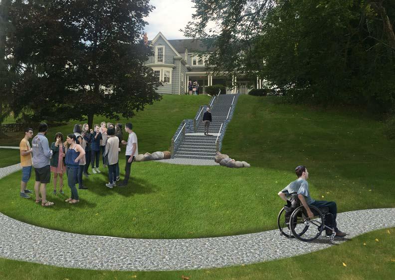
24 Zone 2 : Transition Zone The Transition Zone begins at the top of the slope immediately behind the houses and plaza and extends down to the base of the slope. This zone provides access from the house to the pool and includes the original fieldstone wall and remnants of early plantings including elm and Norway spruce. Other trees include arborvitae, Norway maple, and mulberry. A wood staircase behind the Allen House provides pedestrian access down the slope to the open space on the west side of the pond. It appears that the stairs are placed over cement steps with fieldstone edges that were built just after the city purchased the property. The slopes of the area consist of maintained lawn. Plan for Transition Zone The Master Plan for the Transition Zone shows removal of undesirable trees and replacement with modern elm cultivars. From early photographs of this area it appears that elm plantings formed a glade with maintained lawn and minimal plantings. The Museum s Landscape Master Plan restores and enhances, in both a timeless and contemporary setting, the natural beauty of a historically significant part of our community. James Cunningham, Museum Board member A significant new feature proposed for the Transition Zone is the concrete steps and fieldstone wall to replace the wood staircase. The proposed stairs with walls and handrails provide a safe route for pedestrians to move from the patio behind the Allen House to the woodland trail and pond at the bottom of the slope. The relatively large landing areas of the steps can allow people to congregate for small venues on an intimate scale. Transition Zone Programming and Community Engagement Opportunities: Education and Intimate Gatherings Stair design provides for multi-use as small amphitheater-like performance area on lower lawn Open lawn provides area for traditional lawn activities such as picnics Wi-Fi based interpretive education about overall site history from pioneer period to present Small garden area for daylilies to feature historic varieties and interpretation of Allen House landscape Outdoor photography and art programs and display at stone wall The images below show the characteristics of the Transition Zone and the concept for the Landscape Master Plan. (See Attachments for additional views). Page 16


25 Existing conditions and analysis of the Transition Zone I m very excited, as a member of the Museum Board and the Friends Board, regarding the Landscape Master Plan for the museum grounds. These plans will help the community learn more about the grounds and its history. Marty Logue, Museum Board member Conceptual Master Plan for the Transition Zone Page 17
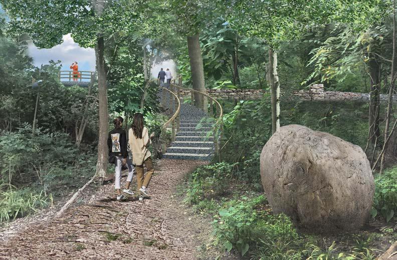
26 Zone 3: Riverine/Woodland Zone The Riverine/Woodland Zone begins at the top of the slope immediately west of the Allen House and extends to the Rouge River. This space offers an opportunity for residents to enjoy a secluded natural area within the city with trails and the potential to experience the river in close proximity. Plan for Riverine/Woodland Zone The Master Plan for the riverine/woodland zone proposes the creation of a climax woodland with the removal of invasive species and planting of sugar maples and associated sub-canopy and ground layer plants. A decision was made to keep the existing trails with the replacement of the timber steps with stone steps and a handrail. To conform to the existing Rouge River Trails Corridor Master Plan, a new path is proposed which runs parallel to the existing stone wall from the entry of the existing trail, where an overlook is proposed, and exiting at Maple Road. The steep slopes in this area will necessitate the use of boulder retaining walls to allow the layout of the path. What distinguishes Birmingham from our neighbors is the diversity of our topography the same that Birmingham s founders (Hamilton, Hunter, Pierce, and Willits) observed 200 years ago. The Museum s grounds are part of this landscape, and making them more accessible to the public gives a starting point to tell Birmingham s history and educate future generations about the environment. Russ Dixon, Museum Board member The original fieldstone wall is proposed to be stabilized and the sections that have fallen will be rebuilt following the original line of the wall. The boulder retaining walls will stabilize the slope and prevent further undermining of the original wall. Also to conform to the Rouge River Trails Corridor Master Plan, a boardwalk is proposed at the intersection of the existing trails which provides access to the Rouge River with a wood deck overlook. Large boulders as sculpture are proposed in the woodland zone. Riverine/Woodland Zone Programming and Community Engagement Opportunities: Natural Habitat, Native American and Cultural History, and Education River Rouge natural history and landscape Native American presence in the area and land use Settlement and pioneer period of Birmingham and importance of Rouge River Wildlife and natural habitat information and interpretive materials (Wi-Fi/electronic) Invasive species vs. native plants-tours and interpretive materials Bird watching programs Other nature programs and tours The images below show the characteristics of the Transition Zone and the concept for the Landscape Master Plan. (See Attachments for additional views). Page 18


27 Existing conditions and analysis of the Riverine/Woodland Zone I m so inspired by our board s dedication to making our museum a cultural highlight of the community. I will always take pride in this opportunity to help with planning for our exceptional landscape and give back to our very unique and special city! Judith Keefer, Museum Board member Conceptual Master Plan for the Riverine/Woodland Zone Page 19
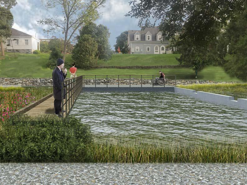
28 Zone 4: Pond Zone The Pond Zone comprises the north portion of the museum property and includes the gentler slopes at the base of the transition zone and extends to Willits Street. A main goal of the Master Plan is to provide handicap parking along Willits Street with access to the museum property and especially to the pool and pond area. The preservation and interpretation of the swimming pool within the pond is an equally important goal, as this is an extremely unique use of the spring-fed pond. Plan for Pond Zone The Master Plan for the Pond Zone proposes a handicap accessible path from a new sidewalk along Willits Street around the pond to a staging area at the historic swimming pool location, then to a seating area on the west side of the pond, and finally to the new overlook at the woodland trail. The construction of this path will necessitate the use of boulder retaining walls to create the level surface for the path. This path is proposed to consist of crushed limestone and will include plantings along the pond side to act as a barrier to the pond below. The interpretation of the swimming pool will be accomplished by the construction of a boardwalk along the east edge to complete that side. This boardwalk will also provide an opportunity to experience the pool right in the middle of the pond. A wood fence with cable railing is proposed for the west side of the boardwalk and a curb is proposed for the east side of the boardwalk. A water garden is proposed to the east of the boardwalk, giving an opportunity for visitors to learn about native water plants. A stone surface area is proposed for the south side and the existing concrete wall defines the north edge of the pool. This stone surface and associated new stone wall allows a relatively large space where groups of people could congregate. To complete the rectangular shape of the swimming pool, a divider is proposed that runs from the south side of the pond to the north side. Care should be taken to preserve existing historical fabric so the remaining walls of the pool should be stabilized and maintained. The boulder walls and new fieldstone wall should be constructed with a different pattern to distinguish these new walls from original walls. Pond Zone Programming and Community Engagement Opportunities: Barrier-Free Public Access and Polio History Wi-Fi/online interpretive materials about poliomyelitis and the unique Allen House pool for Jim Allen s physical therapy Acknowledgment of importance of ADA and barrierfree access in signage and surroundings Barrier-free outdoor programming for all ages Interpretive programs for natural wetlands, native water plants, and wildlife Educational activities and programs on environmental value of birds, bees, bats, and butterflies and associated wild plants and flowers for habitat Barrier-free tours throughout grounds, including Pool area, Rouge overlook and Allen and Hunter Houses The images below show the characteristics of the Transition Zone and the concept for the Landscape Master Plan. Page 20


29 Existing conditions and analysis of the Pond Zone It is especially fitting that the Landscape Master Plan pays special attention to accessibility as it echoes the physical challenges young James Allen faced as he struggled to overcome the effects of polio. Lori Eaton, Museum Board member Conceptual Master Plan for the Pond Zone Page 21

30 VI. Capital Improvements and Funding Page 22


31 This conceptual Landscape Master Plan is intended to provide a guideline for long-term planning and project development. Each zone can be approached as a separate project for planning and funding purposes; however available grants, changing conditions, or other needs may make it more efficient to combine certain elements from different zones. Whenever possible, work will be coordinated with other city Parks and Recreation projects for purposes of timing, to avoid duplication, or to enhance progress. Establishing priorities by zone or project component will assist with planning, especially as regards targeted fundraising and grants. The Landscape Master Plan assumes that funding will be projectspecific, but as part of a big picture that can be communicated to particular granting organizations and potential sponsors. Special interest grants and private donors are expected to figure prominently in all funding, and some likely sources are noted in the table that follows. Fund-raising initiatives will be held at the museum as well, which will also help connect the community physically to the landscape, promoting the museum s mission. PRIORITY LEVELS Four levels of priority with their expected timelines are used in the table on the following page: Priority Priority Priority Priority Photo by Carroll Deweese, 2016 (Components of each zone area are sequentially identified with decimals, e.g., 2.1, 2.2 as first and second steps in Priority 2) Page 23
32 TABLE-MASTER LANDSCAPE CAPITAL IMPROVEMENT AND FUNDING Project Component Priority Cost Comments Potential Funding Sources Estimates Heritage Zone 1.0 The visibility and impact of improvements in the Heritage Zone have the highest priority because they lend themselves well to enhanced programming and continued funding for other parts of the plan Design 1.1 $ 3, Friends of Museum/City Construction 1.2 Anticipated funding sources for construction includes a tree removal $ 4, Tree removal coordinated with Parks to be re-planted combination of grants, donations, funds from Friends of the new plant material deciduous trees $ 1, elsewhere when possible Museum, and fundraising. Volunteers may assist with garden bed preparation. Plant material may be available densiformis yew $ 3, through sponsorships or partnerships winter gem boxwood $ 3, garden bed preparation $ 6, Coordinate work with existing DPS maintenance plan wood fence $ 2, metal edging $ stone mulch $ Subtotal $ 24, Relocate utilities $ 3, DTE estimates represent the majority of the cost, but do not include relocation of other shared line users Donations combined with grants Priority Priority Priority Priority
33 Project Component Priority Cost Comments Potential Funding Sources Estimates Pond Zone 2.0 Additional Survey Survey will determine detail for construction at pond and 2.1 $ 7, will complete needed topography Grants, fundraising + Friends Engineering Plan 2.2 $ 15, Grading plan for ADA paths around pond Grants, fundraising + partnerships Design (Pond & Transition Zones) 2.3 $ 5, Transition Zone & Pond Zone to be designed together Friends and donations Construction 2.4 tree removal $ 6, Anticipated funding sources for construction includes a shrub removal $ 4, combination of grants, donations, funds from Friends of the pond digging $ 10, Museum, and fundraising. Plant material may be available boulder retaining walls $ 39, through sponsorships or partnerships stone walls $ 31, crushed limestone path $ 7, boardwalk $ 23, wood and cable rail fence $ 2, concrete sidewalk & pad $ 8, benches $ stone patio $ 14, new plant material $ 25, Subtotal $ 200, Transition Zone 3.0 Design (see Pond Zone) 2.3 Transition Zone & Pond Zone to be designed together Construction 3.1 tree removal $ 15, stone walls $ 62, stone steps $ 27, exposed aggregate concrete $ 7, new plant materialdeciduous trees $ 3, Subtotal $ 115, Anticipated funding sources for construction includes a combination of grants, donations, funds from Friends of the Museum, and fundraising. Plant material may be available through sponsorships or partnerships
34 Project Component Priority Cost Estimates Woodland/Riverine Zone 4.0 Design 4.1 $ 5, Construction 4.2 tree removal $ 7, boulder retaining walls $ 86, large boulders $ 9, stone wall $ 38, stone steps $ 26, crushed limestone path $ 6, crushed limestone pad $ 1, boardwalk wood and metal hand rail $ 4, river overlook $ 14, new plant material $ 25, benches $ invasive species eradication $ 12, Subtotal $ 232, Comments Cost estimates for construction items are likely to change over the projected time period but are presented here in current dollars. Potential Funding Sources The Woodland/Riverine Zone has a higher level of cost but also may be eligible for grants because of multi-community involvement and importance in Michigan watershed management. Anticipated funding sources for construction includes a combination of grants, donations, funds from Friends of the Museum, and fundraising. Sponsorships or partnerships will be important for this zone, but the possibility of large scale corporate volunteer assistance is also greater for some components. Grand Total $ 572,935.00
35
36
37
38
39 Appendix B Comments from January 16, 2018 Museum Board Special Meeting/Joint Workshop with Parks and Recreation Board, Historic District Commission, and Public (Heritage Zone): Parks and Recreation Board questions related to 1. Tree restoration and replacement; distinction of volunteer trees vs. intentional/original landscape design, transplanting procedure and costs, use of proposed elm cultivars Historic District Commission questions related to 2. The impact of volunteer tree removal and replacement with smaller, younger trees 3. Handicap/barrier free access; current accessibility near museum for parking and access and proposed additional access at Willits Street Public questions related to 4. Planned designated handicapped parking on Willits Street as part of existing street parking (Transition Zone): Parks and Recreation Board questions related to 1. Construction details of proposed stairs and adjacent fieldstone walls Historic District Commission questions related to 2. Lighting design opportunities 3. Benefits of using concrete for safety, cost, and historical accuracy There were no public questions (Riverine/Woodland Zone): Parks and Recreation Board questions related to 1. Locating a children s play area along the Rouge River 2. Clarification that the Rouge River Master Plan is conceptual only 3. Use of crushed limestone in the zone for barrier free access; barrier free paths from Willits to Maple 4. Proposed replacement of rotting timber steps with stone 5. Prevalence of invasive species and maintenance costs There were no questions from the Historic District Commission or the public (Pond Zone): Parks and Recreation Board questions related to 1. Historic use of pool for polio physical therapy by Jim Allen; no public use of pool will be permitted 2. Provisions for water flow in proposed pond and pool design 3. Possibility of future water garden in pond 4. Use of vegetative barriers to maintain safety at edge of pond and depth estimates 5. Proposed relocation of utilities underground 6. Uncertain nature of original pool divider; goal is to educate about the history and its association with disabilities and to emulate the original pool barrier edge, as complete restoration would be costly Historic District Commission questions related to 1. Ability to lower water to expose concrete structures for study 2. Cost of reconstruction of pool s divider wall; possibilities of partial reconstruction as an educational approach 3. Cost and difficulty of dredging; permitting issues with Michigan Department of Environmental Quality (MDEQ) 1. Reconstruction of MDEQ-required wetlands is a small amount of square footage as an offset of spring seeps There were no questions from the public
40 Appendix C Comments from Parks and Recreation Board Master Plan Process, September and October, 2017 A. October 3, 2017 Open House Recommendations (Parks-Rec Master Plan draft p. 134) 1. historical games/playground at museum (1 comment) 2. outdoor museum area at museum (1 comment) B. Public Engagement Resource Mapping (Parks-Rec Master Plan draft p. 137) 3. no recommendations C. Survey Responses-Park Use (Parks-Rec Master Plan draft p. 155) respondents of 441, or 4.4% (includes Allen/Hunter House facilities) D. Survey Comments-(Parks Rec Master Plan draft p. 197) 5. #70- Partnering with the schools, library, BBAC, museum, NEXT, Community House, etc is vital. 6. #74-The Museum Park has been forgotten. It should be developed as an outdoor historic museum including walking exhibits and a game/play area.
41
42
43
44
 cedar shade structures were built and installed in the")
 more shade structures to be placed in the remaining two (2) half circle seating areas, and funds have been allocated in the 2018-2019 Budget")
45 MEMORANDUM Department of Public Services DATE: January 3, 2019 TO: FROM: SUBJECT: Parks and Recreation Board Members Carrie A. Laird, Parks and Recreation Manager Barnum Park Shade Structure Purchase In 2013, as part of the Phase II Landscape Improvements, two (2) cedar shade structures were built and installed in the center Heart of the Park seating and promenade area at Barnum Park. The Barnum Park Phase II Landscape Plan calls for two (2) more shade structures to be placed in the remaining two (2) half circle seating areas, and funds have been allocated in the Budget in the amount of $30,000 to accomplish this project. Recently, a prospective donor has come forward with interest in contributing $15,000 toward the purchase and installation of the two (2) new structures. 1
Landscape Master Plan
 2018 Landscape Master Plan Brian Devlin, Nagy Devlin Land Design Leslie Pielack, Birmingham Museum Approved by the Museum Board, 2/20/2018 Accepted by the City Commission, 3/12/2018 This Landscape Master
CITY OF BIRMINGHAM MUSEUM BOARD AGENDA 556 W MAPLE Thursday, September 7, :30 PM
 CITY OF BIRMINGHAM MUSEUM BOARD AGENDA 556 W MAPLE Thursday, September 7, 2017 5:30 PM Mission Statement: The Birmingham Museum will explore meaningful connections with our past, in order to enrich our
Parks and Recreation Board Agenda Department of Public Services 851 South Eton-Conference Room Wednesday, April 12, :30 PM
 Parks and Recreation Board Agenda Department of Public Services 851 South Eton-Conference Room Wednesday, April 12, 2017 6:30 PM I. Call to order II. Approval of the minutes of : Tuesday, March 7, 2017
ATTACHMENT A AERIAL PHOTO OF McINTIRE PARK EAST
 ATTACHMENT A AERIAL PHOTO OF McINTIRE PARK EAST McIntire Botanical Garden Request for Proposals Attachments Page 1 of 33 ATTACHMENT B - MEMORANDUM OF AGREEMENT WITH THE CITY OF CHARLOTTESVILLE McIntire
Preliminary Sketch Plan for Fort Hunter Park
 Preliminary Sketch Plan for Fort Hunter Park Public Presentation November 19, 2009 Dauphin County Parks and Recreation 100 Fort Hunter Road Harrisburg, PA 17110 (717) 599-5188 www.dauphinc.org THOMAS COMITTA
The John Bartram Association Action Plan to advance the 10 year Strategic Plan
 The John Bartram Association 2013-2015 Action Plan to advance the 10 year Strategic Plan We are poised to take significant leaps with the opportunities that surround us. In the next three years we are
A PERSON DESIGNATED WITH THE AUTHORITY TO MAKE DECISIONS MUST BE PRESENT AT THE MEETING.
 AGENDA BIRMINGHAM HISTORIC DISTRICT COMMISSION MUNICIPAL BUILDING-COMMISSION ROOM-151 MARTIN STREET WEDNESDAY March 1, 2017 ***************7:00 PM*************** 1) Roll Call 2) Approval of the HDC Minutes
Philip A. Ginsburg, General Manager Toks Ajike, Acting Planning and Capital Program Director
 Date: March 7, 2018 To: Through: From: Subject: Recreation and Park Commission Capital Committee Philip A. Ginsburg, General Manager Toks Ajike, Acting Planning and Capital Program Director Dan Mauer,
WARM SPRINGS PARK MASTER PLAN
 TABLE OF CONTENTS page 1.0 Introduction and Overview 1 2.0 Information Gathering 2 3.0 Conceptual Alternative Development 8 4.0 Master Plan Development 14 5.0 Construction Cost Estimates 19 LIST OF FIGURES
April 11, 2016 Park Board Chair and Commissioners General Manager Vancouver Board of Parks and Recreation New Brighton Salt Marsh - Preferred Concept
 TO: FROM: SUBJECT: April 11, 2016 Park Board Chair and Commissioners General Manager Vancouver Board of Parks and Recreation New Brighton Salt Marsh - Preferred Concept RECOMMENDATION A. THAT the Vancouver
Report to: Development Services Committee Report Date: April 24, 2017
 SUBJECT: Cornell Rouge National Urban Park Gateway - Report on Design Charrette and Next Steps PREPARED BY: Lilli Duoba, MES, MCIP, RPP, Manager, Natural Heritage (ext. 7925) REVIEWED BY: Marg Wouters,
Hidden Pointe Landscape Master Plan. June, archi terra
 Hidden Pointe Landscape Master Plan June, 2006 t h e archi terra g r o u p 1 Table of Contents Background Purpose and Goals of the Master Plan Master Plan Process Existing Conditions Entrance Hidden Pointe
Master Plan Presentation August 12, 2015
 Master Plan Presentation August 12, 2015 A vision for tomorrow... May, 13 2015 prepared for: prepared by: SITE LOCATION SITE NTS SITE ANALYSIS +/- 17.8 Ac. RESIDENTIAL HOMES 1 2 RAIL ROAD (SAFETY CONCERNS)
Call for Artists for: Design and Construction of Environmental Art Activation Story Mill Community Park, Bozeman, MT
 Call for Artists for: Design and Construction of Environmental Art Activation Story Mill Community Park, Bozeman, MT Seeking artists to design, fabricate and install art elements in the nature sanctuary
The Brooks Estate Master Plan Summary
 The Brooks Estate Master Plan Summary - 2016 The Brooks Estate Master Plan was created in 2011/2012, discussed for two years with the Medford City Council and then rejected by the Medford City Council
Long Branch-Wayne Local Park Renovation Project
 Montgomery Parks Long Branch-Wayne Local Park Renovation Project Community Meeting #2 September 20, 2016 Oak View Elementary School 7:00-9:00 PM Welcome / Team Introductions M-NCPPC (Montgomery Parks)
Mendota Heights 2040 Comprehensive Plan Draft Vers
 4 Parks and Trails The City of Mendota Heights boasts a variety of recreational and open space opportunities. Few cities can claim access to regional trails, riverside and lakeside parks, scenic bluffs
Design Considerations
 Essential to the development of a successful Master Plan for the Park Complex is input from the community that the park will serve. The community outreach component of the planning process included numerous
Las Colonias Park Master Plan
 2013 Las Colonias Park Master Plan City of Grand Junction June 2013 Introduction Las Colonias Park, a 101 acre parcel on the edge of the Colorado River south of downtown, was deeded to the City of Grand
South th E ast Communit ity Centre (SECC)
") South East Community Centre (SECC) 1 New Park Design & Community Centre Update Thursday, February 8, 2018 Public Open House Thank you for attending this Open House! The town and the Consulting Team will
South East Community Centre (SECC) 1 New Park Design & Community Centre Update Thursday, February 8, 2018 Public Open House Thank you for attending this Open House! The town and the Consulting Team will
BISCUIT RUN PARK MASTER PLAN
 BOARD OF SUPERVISORS November 14, 2018 BISCUIT RUN PARK MASTER PLAN COUNTY OF ALBEMARLE ANHOLD ASSOCIATES Contents Project Introduction Property Background County Park Planning Process Existing Site &
ADOPTED CAPITAL IMPROVEMENT PROGRAM BUDGET ARROYO PROJECTS
 ADOPTED CAPITAL IMPROVEMENT PROGRAM BUDGET ARROYO PROJECTS HAHAMONGNA FY 212-216 Capital Improvement Program Priority Description Total Estimated Costs Appropriated Through FY 211 Adopted FY 212 FY 213
MISSISSIPPI GORGE REGIONAL PARK MASTER PLAN
 MISSISSIPPI GORGE REGIONAL PARK MASTER PLAN Minneapolis Park and Recreation Board CAC MEETING #1 APRIL 23, 2018 AGENDA Mississippi Gorge Regional Park Master Plan CAC #1 01 / Welcome and Calling Circle
BRADENTON RIVERWALK EXPANSION MASTER PLAN
 BRADENTON RIVERWALK EXPANSION MASTER PLAN INTRODUCTION & AGENDA Process Update Community Engagement Summary Center for Active Design (CfAD) Recommendations Context and Existing Conditions Master Plan Alternatives
Pomegranate Center and Tully s Coffee Gathering Grounds program partnership Butterfly Park Gathering Place Project Preliminary Design I.
 Pomegranate Center and Tully s Coffee Gathering Grounds program partnership Pomegranate Center, ARTS /A Reason To Survive, Olivewood Gardens, San Diego Foundation, and City of National City Butterfly Park
STAFF RECOMMENDATION: Adopt the Parks and Recreation Master Plan 2013, or take other action as deemed appropriate.
 Regular 7. CITY COUNCIL AGENDA Meeting Date: 12/02/2013 TITLE: Parks and Recreation Master Plan 2013 Adoption Proposal - Dwight Curtis Responsible Staff: Dwight Curtis Backup Material: Backup material
Lowe Park Master Plan Update Marion, IA August 25 th, 2011
 Lowe Park Master Plan Update Marion, IA August 25 th, 2011 Lowe Park Master Plan Update Concept Plan - June 1 st, 2011 Agenda 1 - INTRODUCTION Vision Statement Aerial of Existing Condition 2 MASTER PLAN
Town of Peru Comprehensive Plan Executive Summary
 Town of Peru Comprehensive Plan Executive Communities that plan grow by choice, not by chance. A plan makes growth thoughtful, understandable, and predictable. A plan shows that a community is managing
Roberts Field Public Input Session AS RECOMMENDED BY THE ROBERTS FIELD IMPROVEMENT COMMITTEE UPDATED 6/20/17
 Roberts Field Public Input Session AS RECOMMENDED BY THE ROBERTS FIELD IMPROVEMENT COMMITTEE UPDATED 6/20/17 Committee Members William Arrington Bill Askenburg - Chair Chris Crafts Kate Gleisberg Alice
2011 ASLA Design Awards. Centennial Park Merit Award Design Concepts CLA, Inc. Design over $500,000 Construction Budget
 2011 ASLA Design Awards Centennial Park Merit Award Design Concepts CLA, Inc. Design over $500,000 Construction Budget 2011 ASLA Colorado Professional Design Awards Project Name: Category: Location: Const.
POPS Advisory Committee Meeting May 31, 2018
 POPS Advisory Committee Meeting May 31, 2018 NOTE: This presentation is a working document, and some recommendations or ideas may have evolved or changed based on continued discussions and additional analyses.
City of Farmington. Downtown Plan. Amendment to the 1998 Master Plan Adopted October 11, 2004
 City of Farmington Amendment to the 1998 Master Plan Adopted October 11, 2004 Introduction Planning Background 1 Scope and Components of the Plan Amendment 2 Concept Introduction 3 Plan Concepts 3 Conceptual
Community Conservation Workshop. Lake Placid
 Community Conservation Workshop Lake Placid 2 Community Conservation Program Welcome! We have designed a Community Conservation Program that listens to the needs of community members. We are conducting
Clarendon Park Framework Plan. Chicago Park District Department of Planning & Development June 7, 2008
 Clarendon Park Framework Plan Chicago Park District Department of Planning & Development June 7, 2008 1 Table of Contents Framework Plan Purpose.3 Radius Map one mile.4 Aerial Map...5 Existing Park Layout.6
The Vision. Photo provided by The Minervini Group. 46 Vision, Objectives & Strategies
 Vision, Objectives & Strategies The is the public framework and guide for future development of the Grand Traverse Commons. The establishes public polices for infrastructure, the preservation of natural
Gas Works Site Land-Use Study
 City of New Westminster Background Context 2 Neighbourhood Context 3 Program Elements 4 Proposed Site Planning Approach 5 Design Rationale 10 Design Elements 11 Phasing 21 C o n t e n t s b a c k g r o
APPENDIX D: PARKS AND RECREATION ACTION PLAN
 APPENDIX D: PARKS AND RECREATION ACTION PLAN Goals The following goals are specific to the development, maintenance, and operation of the existing parks in the Township, as well as the acquisition and
CITY COUNCIL STUDY SESSION MEMORANDUM
 City and County of Broomfield, Colorado CITY COUNCIL STUDY SESSION MEMORANDUM To: From: Prepared by: Mayor and City Council Charles Ozaki, City and County Manager Kevin Standbridge, Deputy City and County
VILLAGE OF BOLTON HERITAGE CONSERVATION DISTRICT PLAN
 Page 1 1. INTRODUCTION AND BACKGROUND 1.1 THE PROJECT VILLAGE OF BOLTON HERITAGE CONSERVATION DISTRICT PLAN TERMS OF REFERENCE The Town of Caledon (Town) is a large, predominantly rural municipality with
Re: Coastal Manor Addition, Conceptual Site Plan Submittal Orey Gadway, Owner/ Administrator Coastal Manor 20 West Main St Yarmouth, ME 04096
 September 06, 2017 Alex Jaegerman, FAICP Director of Planning and Development 200 Main Street Yarmouth, ME 04096 Re: Coastal Manor Addition, Conceptual Site Plan Submittal Orey Gadway, Owner/ Administrator
PUBLIC SPACES MASTER PLAN UPDATE (POPS) Joint Facilities Advisory Commission (JFAC) November 28, 2018
 Joint Facilities Advisory Commission (JFAC) November 28, 2018") PUBLIC SPACES MASTER PLAN UPDATE (POPS) Joint Facilities Advisory Commission (JFAC) November 28, 2018 1 AGENDA POPS Planning Context Timeline Public Input Final POPS Draft Next Steps 2 PLANNING CONTEXT
PUBLIC SPACES MASTER PLAN UPDATE (POPS) Joint Facilities Advisory Commission (JFAC) November 28, 2018 1 AGENDA POPS Planning Context Timeline Public Input Final POPS Draft Next Steps 2 PLANNING CONTEXT
MILL POND OVERLOOK. A project of the Town of Oyster Bay. Prepared by Cameron Engineering & Associates, LLP
 MILL POND OVERLOOK A project of the Town of Oyster Bay Prepared by Cameron Engineering & Associates, LLP Funded in part through an EPF grant from the NYS Department of State Project Goals & Advisory Committee
AGENDA Pony Barn Recreation Area Working Group
 AGENDA Pony Barn Recreation Area Working Group Monday, December 15, 2014, 6:30 pm Meeting Purpose: The Working Group has been established to develop and review potential changes to the Pony Barn Recreation
BIRMINGHAM HISTORIC DISTRICT COMMISSION MINUTES OF SEPTEMBER 13, 2017 Municipal Building Commission Room 151 Martin, Birmingham, Michigan
 BIRMINGHAM HISTORIC DISTRICT COMMISSION MINUTES OF SEPTEMBER 13, 2017 Municipal Building Commission Room 151 Martin, Birmingham, Michigan Minutes of the regular meeting of the ( HDC ) held Wednesday, September
10.0 Open Space and Public Realm
 10.0 Open Space and Public Realm 10.0 Open Space and Public Realm The Public Open Space System is comprised of: outdoor spaces available for public use that are either publicly owned (e.g., parks and
30% DRAFT GAINSBORO PARK IMPROVEMENT PROJECT THE CITY OF PLEASANT RIDGE CITY OF PLEASANT RIDGE, OAKLAND COUNTY, MICHIGAN
 LEGAL PROPERTY DESCRIPTION SEE NOTES SHEET FOR LEGAL PROPERTY DESCRIPTIONS THE CITY OF PLEASANT RIDGE GAINSBORO PARK IMPROVEMENT PROJECT CITY OF PLEASANT RIDGE, OAKLAND COUNTY, MICHIGAN 4444 Second Avenue
CITY OF CHARLOTTESVILLE, VIRGINIA CITY COUNCIL AGENDA
 CITY OF CHARLOTTESVILLE, VIRGINIA CITY COUNCIL AGENDA Agenda Date: December 16, 2013 Action Required: Adoption of Resolution Presenter: Staff Contacts: Title: James E. Tolbert, AICP, Director of NDS James
February 27, 2018 City Council Presentation The Crown Jewel Park in the City of Fairfax
 February 27, 2018 City Council Presentation The Crown Jewel Park in the City of Fairfax Master Planning Charge Van Dyck Park s first Master Plan will provide the City with a road map as to how best incorporate
East Panorama Ridge Concept Plan Amendment
 Page 1 of 7 L003 : East Panorama Ridge Concept Plan Amendment Corporate NO: L003 Report COUNCIL DATE: March 4, 2002 REGULAR COUNCIL LAND USE TO: Mayor & Council DATE: February 27, 2002 FROM: General Manager,
Architectural Inventory Form
 OAHP1403 Rev. 9/98 COLORADO CULTURAL RESOURCE SURVEY Architectural Inventory Form Official eligibility determination (OAHP use only) Date Initials Determined Eligible- NR Determined Not Eligible- NR Determined
Washington Park Diagonal
 Public Input Meeting August 3, 2011 Nicole Stahly RLA DPR Project Manager Jesse Clark RLA, LEED Stream Design Paul Thomas RLA Stream Design Kerry White RLA Urban Play Studio Tonight s Agenda 1st Meeting:
1.0 Purpose of a Secondary Plan for the Masonville Transit Village
 Report to Planning and Environment Committee To: Chair and Members Planning & Environment Committee From: John M. Fleming Managing Director, Planning and City Planner Subject: Masonville Transit Village
Roanoke Rapids Streetscape Master Plan. City Council Presentation
 SCHEDULE: Stakeholder Meeting/Kick off November,2016 Master Planning Phase (November March 2017) Public Meeting #1 December 13, 2016 Review Meeting with Key Stakeholders Refine Concepts Based on Input
FY Capital Improvement Program Parks and Landscaping. 8 - Summary
 PARK PROJECTS FY 211-215 Capital Improvement Program Description FY 21 FY 211 FY 212 FY 213 FY 214 FY 215 1 Restroom Bldgs (Replace or Construct)-Jefferson, McDonald, 5,774,623 4,669,623 1,15, Allendale,
M E M O R A N D U M February 21, 2018
 M E M O R A N D U M February 21, 2018 Project: Action Requested: Background Information: CP18-001, Ordinance No. 1060-A, Amendment to the City of Southlake Parks, Recreation & Open Space / Community Facilities
Call for Artists Gateway Island Ashland Oregon Requests for Qualifications (RFQ)
") Call for Artists Gateway Island Ashland Oregon Requests for Qualifications (RFQ) The Project The Ashland Public Art Commission (PAC) seeks an artist, or artist team, to develop a site specific, permanent,
Call for Artists Gateway Island Ashland Oregon Requests for Qualifications (RFQ) The Project The Ashland Public Art Commission (PAC) seeks an artist, or artist team, to develop a site specific, permanent,
THE CORPORATION OF THE DISTRICT OF CENTRAL SAANICH CENOTAPH COMMITTEE Monday, April 3, 2017, 4:00 PM Council Chambers AGENDA
 THE CORPORATION OF THE DISTRICT OF CENTRAL SAANICH CENOTAPH COMMITTEE Monday, April 3, 2017, 4:00 PM Council Chambers AGENDA 1. CALL TO ORDER 2. APPROVAL OF AGENDA 3. ADOPTION OF MINUTES 3.1. Draft Minutes
CITY OF KEIZER MASTER PLAN APPLICATION & INFORMATION SHEET
 CITY OF KEIZER MASTER PLAN APPLICATION & INFORMATION SHEET PRE-APPLICATION CONFERENCE Prior to the actual filing of a Master Plan application, it is strongly recommended that the applicant contact Planning
North Oakville East Parks Facilities Distribution Plan. November, 2009
 North Oakville East November, 2009 POLICY CONTEXT 1) Purpose a) The purpose of this document is to be a guide for the location, configuration, design and development of the parks system for the North Oakville
The Corporation of Delta. COUNC~L REPORT Regular Meeting. Burnsview Secondary School/Chalmers Park Memorandum of Understanding
 The Corporation of Delta COUNC~L REPORT Regular Meeting Fa 13 To: Mayor and Council File No.: 14035-20/ChaP From: Parks, Recreation & Culture Department Date: June 19, 2015 Burnsview Secondary School/Chalmers
ACADEMY AREA CONCEPT PLAN
 ACADEMY AREA Strip ling C hape l Roa d CONCEPT PLAN 7 S2 U Stripling 52 ROADWAYS AND PARKING: ADVENTURE PLAYGROUND AND SPRAYGROUND: Current roadways follow existing drives. It is recommended that the Folds
SALISBURY TOMORROW Our Vision
 SALISBURY TOMORROW Our Vision Salisbury is committed to supporting a high quality of life and sense of community for all residents. These commitments need to be reflected in our community programs, services
3. VISION AND GOALS. Vision Statement. Goals, Objectives and Policies
 Vision Statement Queen Creek s interconnected network of parks, trails, open spaces and recreation opportunities provide safe and diverse activities and programs that sustain its unique, small town, equestrian
(Exhibit A) Site Plan Adoption Detail and Support Information
 Site Plan Adoption Detail and Support Information") McCormick Park Master Site Plan (Exhibit A) Site Plan Adoption Detail and Support Information July, 2003 McCormick Park Site Plans.... 2-3 McCormick Park Site Plan Comparison... 4 Basic Assumptions about
McCormick Park Master Site Plan (Exhibit A) Site Plan Adoption Detail and Support Information July, 2003 McCormick Park Site Plans.... 2-3 McCormick Park Site Plan Comparison... 4 Basic Assumptions about
North Adelaide Playspace and Pocket Orchard
 The Adelaide City Council invites engagement from the community about Playspace and Pocket Orchard Project Summary Adelaide City Council invites feedback from the community on the Tidlangga (Park 9) Playspace
Sustainably Designed Structures in an Urban Woodland
 GIMME SHELTER Sustainably Designed Structures in an Urban Woodland Project Purpose Gimme Shelter will be a showcase of up to six semi-permanent, functional woodland shelters to enhance the experience of
Community Conservation Workshop. Saranac River Basin Communities
 Community Conservation Workshop Saranac River Basin Communities 2 Community Conservation Program Welcome! We have designed a Community Conservation Program that listens to the needs of community members.
City of Mahtomedi Park System Plan Public Hearing Draft: September 13, 2006
 Chapter 6: IMPLEMENTATION INTRODUCTION Earlier chapters of this Plan analyzed existing conditions, identified park and recreation needs, and proposed park, trail, and open space recommendations. This chapter
Programming Ideas for Parks Professionals
 Programming Ideas for Parks Professionals 6 How to Use this Information This is a list of ideas, suggestions and tips for promoting and incorporating the healthy in nature movement in your parks. Whether
FY Capital Improvement Program Arroyo Projects - Lower Arroyo Summary
 LOWER ARROYO FY 214-218 Capital Improvement Program Description FY 213 FY 214 FY 215 FY 216 FY 217 FY 218 1 Bird Sanctuary Improvements (7749) 35, 225, 125, 2 Lower Arroyo - Implement Master Plan - Signage
DESIGN REVIEW COMMITTEE AGENDA ITEM
 DESIGN REVIEW COMMITTEE AGENDA ITEM AGENDA DATE: OCTOBER 3, 2012 TO: Chair Woollett and Members of the Design Review Committee THRU: FROM: SUBJECT: Leslie Aranda Roseberry, Planning Manager Daniel Ryan,
UAA School of Engineering Parking Garage Master Plan Amendment. 1. Purpose
 UAA School of Engineering Parking Garage Master Plan Amendment 1. Purpose Since the UAA campus master plan was drafted in 2003, adopted in 2004, and amended in 2009 a number of significant changes regarding
November 21, Planning Commission Charter Township of Lyon Grand River Ave. New Hudson, MI 48165
 Planning Commission Charter Township of Lyon 58000 Grand River Ave. New Hudson, MI 48165 Subject: AP-18-68; 11 Mile and Milford Road Park, Site Plan Review #1 Based on site plan dated 11/12/18 Location:
SF REC & PARK STANYAN STREET IMPROVEMENT. Supervisor London Breed District 5. Project Manager Dan Mauer Recreation and Parks Department
 SF REC & PARK STANYAN STREET IMPROVEMENT PLANNING PRESENTATION WEDNESDAY, OCTOBER 19, 2016 Supervisor London Breed District 5 Project Manager Dan Mauer Recreation and Parks Department Design Team William
July 12, Columbus City Council City Hall 90 West Broad Street Columbus, OH RE: I-70/71 Columbus Crossroads Project
 OHIO DEPARTMENT OF TRANSPORTATION DISTRICT 6 400 EAST WILLIAM STREET DELAWARE, OHIO 43015 800.372.7714 Columbus City Council City Hall 90 West Broad Street Columbus, OH 43215-9015 RE: I-70/71 Columbus
City of Plattsburgh DRI: Downtown Streetscapes & Riverfront Access. Downtown Streetscape and Riverfront Access Design
 City of Plattsburgh DRI: Downtown Streetscapes & Riverfront Access Welcome Thank you for coming this evening. Agenda PART I - Project Context The Downtown Revitalization Program Our DRI Projects Other
12 Foot Davis and Adjacent Sites
 Peace River, Alberta Proposed Concept Design Presentation and Discussion January 26, 2010 Peace River Provincial Recreation Area 12 Foot Davis Grave Site Dr. Greene Cairn North Environments Landscape Architects
North Downtown Specific Plan MEMORANDUM
 North Downtown Specific Plan MEMORANDUM MEETING DATE: November 13, 2017 TO: Members of the North Downtown Specific Plan Advisory Committee FROM: Jeanine Cavalli, Senior Planner SUBJECT: Materials for the
New York Avenue Streetscape and Trail Project Public Meeting #1 Summary
 New York Avenue Streetscape and Trail Project Public Meeting #1 Summary I. King Jordan Student Academic Center (SAC) Gallaudet University, Washington, DC February 23, 2017 Table of Contents 1.0 Introduction...
V. Vision and Guiding Principles
 V. Vision and Guiding Principles The Master Plan for the Powers Ferry Corridor seeks a foundation in the desires of the community. At times, various elements of the community offered opposing viewpoints,
ARROYO PROJECTS ADOPTED CAPITAL IMPROVEMENT PROGRAM BUDGET
 A RROYO P ROJECTS ADOPTED CAPITAL IMPROVEMENT PROGRAM BUDGET FISCAL YEARS 214-218 HAHAMONGNA Priority Description 1 Hahamongna Watershed Park - Implement Master Plan 211,6 211,6 (77565) 2 Hahamongna -
quarters Building Our Cultural Quarters Together
 cultural quarters Building Our Cultural Quarters Together Implementation Plan june 2013 To enrich the ability of Montréalers to appreciate art, culture and heritage in its downtown core and throughout
ANCHORAGE PARK REPORT CARD Assessing A Park s Appearance, Function, & Condition
 ANCHORAGE PARK REPORT CARD Assessing A Park s Appearance, Function, & Condition Park Name: Is Your Park an A or an F? Your Name: Contact Information Optional: Date: General Instructions: Phone: Email:
WSU Arboretum Proposal
 WSU Arboretum Proposal The idea of having a botanical garden or arboretum on the Washington State University campus has long been a goal of many people. Committees have been formed in the past and sites
Montana Rail Link Park
 Montana Rail Link Park Neighborhood Open House A Missoula Community Partnership WITH LEADERSHIP FROM THE FRANKLIN TO THE FORT & SOUTHGATE TRIANGLE NEIGHBORHOODS Sovereign Hope Church, (1919 North Ave.)
City of Missoula and Missoula County Open Space Planning Open House
 City of Missoula and Missoula County Open Space Planning Open House FEBRUARY 6, 2018 The following slides contain the display board content from the open house. Please use boards to answer questions in
An Ambitious Plan: Transforming the blighted South Platte River and surrounding environment into Denver s greatest natural resource.
 CONNECTING THE PEOPLE TO THEIR RIVER SOUTH PLATTE RIVER VISION IMPLEMENTATION PROGRAM: GRANT-FRONTIER PARK TO OVERLAND POND PARK REACH The South Platte River Vision Implementation Program (River Vision)
John M. Fleming Managing Director, Planning and City Planner. Old East Village Dundas Street Corridor Secondary Plan Draft Terms of Reference
 Report to Planning and Environment Committee To: From: Subject: Chair and Members Planning & Environment Committee John M. Fleming Managing Director, Planning and City Planner Old East Village Dundas Street
December 1, 2014 (revised) Preliminary Report -- Thomas Jefferson Site Evaluation
 Preliminary Report -- Thomas Jefferson Site Evaluation") December 1, 2014 (revised) TO: FROM: RE Arlington County Board Thomas Jefferson Site Evaluation Working Group by Carrie Johnson, Chair Preliminary Report -- Thomas Jefferson Site Evaluation The Thomas
December 1, 2014 (revised) TO: FROM: RE Arlington County Board Thomas Jefferson Site Evaluation Working Group by Carrie Johnson, Chair Preliminary Report -- Thomas Jefferson Site Evaluation The Thomas
Arkansas River Corridor
 Planning for Access Welcome to the Access Project. This project is a recreational planning effort in response to an interest by regional communities along the Arkansas River corridor. The project plan
South Bend Park. Visioning Plan
 South Bend Park Visioning Plan 2007 South Bend Park, Visioning Program, Executive Summary The South Bend Park Visioning Program began with the receipt of an application from the Friends of South Bend Park,
PLANNING BOARD REPORT PORTLAND, MAINE
 PLANNING BOARD REPORT PORTLAND, MAINE Zero Canal Plaza Development 0 Canal Plaza 2016-162 Cow Plaza 1, LLC Submitted to: Portland Planning Board Date: August 4, 2016 Public Hearing Date: August 9, 2016
Lake and Stream Restoration Project
 Pre-project Fact Sheet May 2012 Toledo Botanical Garden (TBG) is a 60 acre public garden visited by more than 120,000 people annually. It is located in Toledo, Ohio in the Ottawa River watershed within
A Master Plan for High Park s Hillside Garden and other Ornamental Gardens: Recommendations from the High Park Natural Environment Committee
 www.highparknature.org mail@highparknature.org A Master Plan for High Park s Hillside Garden and other Ornamental Gardens: Recommendations from the High Park Natural Environment Committee September 2015
AVONDALE ESTATES GREENSPACE AD-HOC COMMITTEE
 AVONDALE ESTATES GREENSPACE AD-HOC COMMITTEE INVENTORY AND RECOMMENDATIONS REPORT November 7, 2018 Our Mission Statement: To provide assistance and support, through professional expertise in matters of
Mary Bradford, Director of Parks Mike Riley, Deputy Director of Parks John E. Hench, Ph.D., Chief, Park Planning & Stewardship Division
 DATE: September 18, 2009 MCPB Item # # 10 Date: 09/24/09 TO: VIA: FROM: RE: Montgomery County Planning Board Mary Bradford, Director of Parks Mike Riley, Deputy Director of Parks John E. Hench, Ph.D.,
CITY OF ANN ARBOR // Parks + Recreation. Hillary Hanzel Park Planner + Landscape Architect
 CITY OF ANN ARBOR // Parks + Recreation Hillary Hanzel Park Planner + Landscape Architect CITY OF ANN ARBOR // Parks + Recreation 1. Overview of Parks System 2. Recent + Upcoming Capital Projects 3. History
BRIDGING THE GAP: KLYDE WARREN PARK AND THE REVITALIZATION OF CENTRAL DALLAS
 BRIDGING THE GAP: KLYDE WARREN PARK AND THE REVITALIZATION OF CENTRAL DALLAS EDUCATION SESSION HANDOUT ASLA 2015 ANNUAL MEETING & EXPO CHICAGO SATURDAY, 11/7 2:30-4 PM BRIDGING THE GAP: KLYDE WARREN PARK
Chapter 4: Jordan Road Character District
 4: Jordan Road Character District 4.1 Introduction The Jordan Road character district encompasses much of the former Jordan orchard and farmstead, which was a significant part of Sedona s history. The
ENVIRONMENTAL INITIAL STUDY BERKELEY CITYWIDE POOLS MASTER PLAN
 ENVIRONMENTAL INITIAL STUDY FOR THE BERKELEY CITYWIDE POOLS MASTER PLAN CITY OF BERKELEY PARKS RECREATION AND WATERFRONT DEPARTMENT SEPTEMBER 1, 2009 ENVIRONMENTAL INITIAL STUDY BERKELEY CITYWIDE POOLS