McCormick Pit Category 1 Class A License, Pit Below Water For Blueland Farms Limited. Visual Impact Assessment Report February 2013
|
|
|
- Kathlyn Bennett
- 5 years ago
- Views:
Transcription


1 McCormick Pit Category 1 Class A License, Pit Below Water For Blueland Farms Limited Visual Impact Assessment Report February 2013
2 TABLE OF CONTENTS EXECUTIVE SUMMARY... v 1.0 BACKGROUND... 1 Figure 1. Figure 2. Land-Use Map Niagara Escarpment Land Designation Map 2.0 LOCATION... 4 Figure 3. Location Map 3.0 METHODOLOGY... 5 Figure 4. Picture Plane 4.0 LANDSCAPE CHARACTER Context Vegetation Topography Drainage Land Use Cultural Landscape Figure 5. Figure 6. Landscape Character Map View Locations and Viewshed Map 5.0 SIGNIFICANT VIEWS AND VIEWSHEDS Figure 7. View #1: View Northwest at Residence R5 Figure 8. View #2: Hay Field #2 Figure 9. View #3: Hay Field #1 Figure 10. View #4: View South Figure 11. View #5: View South east Figure 12. View #6: View East Figure 13. View #7: View Northeast Table 1. Summary of Significant Views McCormick Pit i Supplementary Visual Impact Assessment Report Harrington McAvan Ltd. Blueland Farms Limited February 2013
3 6.0 VISUAL IMPACTS PHASE A Table 2. Figure 14. Summary of Phase A Visual Impacts Phase A Visual Impacts 6.2 PHASE B Table 3. Figure 15. Summary of Phase B Visual Impacts Phase B Visual Impacts 6.3 PHASE C Table 4. Figure 16. Summary of Phase C Visual Impacts Phase C Visual Impacts 6.4 PHASE D Table 5. Figure 17. Summary of Phase D Visual Impacts Phase DVisual Impacts 6.5 PHASE E Table 6. Figure 18. Summary of Phase E Visual Impacts Phase E Visual Impacts 6.6 PHASE F Table 7. Figure 19. Summary of Phase F Visual Impacts Phase F Visual Impacts 6.7 PHASE G Table 8. Summary of Phase G Visual Impacts 7.0 MITIGATION MEASURES PHASE A Table 9. Figure 20. Summary of Phase A Mitigation Measures Phase A Mitigation Measures 7.2 PHASE B Table 10. Figure 21. Summary of Phase B Mitigation Measures Phase B Mitigation Measures McCormick Pit ii Supplementary Visual Impact Assessment Report Harrington McAvan Ltd. Blueland Farms Limited February 2013
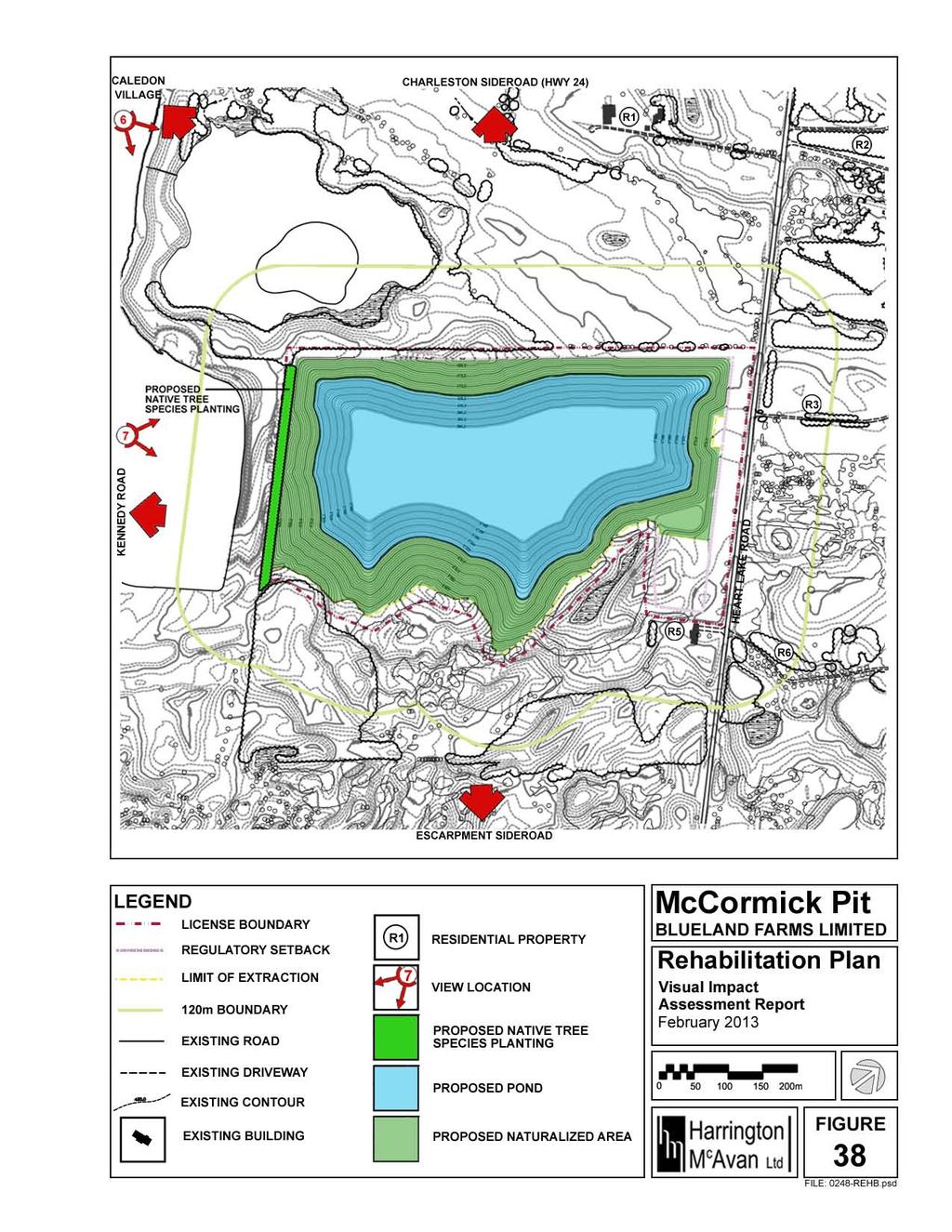
4 7.3 PHASE C Table 11. Figure 22. Summary of Phase C Mitigation Measures Phase C Mitigation Measures 7.4 PHASE D Table 12. Figure 23. Summary of Phase D Mitigation Measures Phase D Mitigation Measures 7.5 PHASE E Table 13. Figure 24. Summary of Phase E Mitigation Measures Phase E Mitigation Measures 7.6 PHASE F Table 14. Figure 25. Summary of Phase F Mitigation Measures Phase F Mitigation Measures 7.7 PHASE G Table 15. Summary of Phase G Mitigation Measures 7.8 SUMMARY Figure 26. View #5: Line of Sight Cross Section Figure 27. Existing View Southeast (View #5) Figure 28. View Southeast (View #5) with proposed temporary seeded acoustical berm Figure 29. View #3: Line of Sight Cross Section Figure 30. Existing View of Hay Field #1 (View #3) Figure 31. View of Hay Field #1 (View #3) with proposed temporary seeded acoustical berm Figure 32. View #1: Line of Sight Cross Section Figure 33. Existing View Northwest at Residence R5 (View #1) Figure 34. View Northwest at Residence R5 (View #1) with proposed temporary seeded acoustical berm Figure 35. View #2: Line of Sight Cross Section Figure 36. Existing View of Hay Field #2 (View #2) Figure 37. View of Hay Field #2 (View #2) with proposed temporary seeded acoustical berm Figure 38. Rehabilitation Plan Figure 39. Existing View South (View #4) Figure 40. View South (View #4) following completion of extraction and rehabilitation McCormick Pit iii Supplementary Visual Impact Assessment Report Harrington McAvan Ltd. Blueland Farms Limited February 2013
5 8.0 LANDSCAPE EVALUATION Table 16. Summary of "Evaluation Unit Scoring Sheets" Table 17. Evaluation Unit Scoring Sheet Caledon Creek (#121) Figure 41. Landscape Evaluation Map 9.0 CONCLUSION REFERENCES APPENDIX I VISUAL IMPACTS APPENDIX II MITIGATION MEASURES McCormick Pit iv Supplementary Visual Impact Assessment Report Harrington McAvan Ltd. Blueland Farms Limited February 2013
6 EXECUTIVE SUMMARY The subject property is approximately 26 hectares (64 acres) in area and is located on the west side of Heart Lake Road about 2km east of Caledon Village in the Town of Caledon, Regional Municipality of Peel. This visual impact assessment report has been prepared in support of the required planning approvals to allow for a Category 1 Class A license, pit below water under the Aggregate Resources Act. An inventory and analysis was prepared to understand the context, existing landscape character, existing visual character, and existing landscape evaluation of the subject property and its surroundings. Potential significant views and viewsheds were identified and assessed for level of significance and value. Finally, potential negative visual impacts from the application were identified and assessed. Using the information collected, mitigation measures were recommended to minimize the negative visual impacts while changing the landscape character and experience of the subject property as minimally as possible. The following mitigation measures are recommended to be implemented before the following phases: Phase A (See Figure 20 for Phase A - Mitigation Measures) 1. Install a seeded berm minimum 3m high within the northwestern regulatory setback adjacent to Area Install a seeded berm minimum 3m high within the northeastern regulatory setback adjacent to Area Install native deciduous and coniferous tree species within the southwestern regulatory setback adjacent to Area 1. Phase B (See Figure 21 for Phase B - Mitigation Measures) 4. Install a seeded berm minimum 3m high within the regulatory setback adjacent to the northwestern property line of Residence R5 to reinforce the existing tree screen Phase C (See Figure 25 for Phase C - Mitigation Measures) 5. Install a seeded berm minimum 3m high within the northeastern regulatory setback adjacent to Area 3. To ensure the existing viewsheds are maintained, if not increased following the proposed extraction operations and rehabilitation, the planting of vegetated visual barriers along Heart Lake Road is not recommended. Seeded berms, minimum 3m high, shall be installed to screen views into the subject lands from Heart Lake Road. Native tree species shall be installed to reinforce areas where the existing vegetated visual barriers will be removed during operations. Once the operations are completed, the seeded berms will have been removed and the native tree species will remain on the subject lands. The recommended visual mitigation measures will minimize the negative visual impacts of the proposed operations, while allowing the subject property to be compatible with its surroundings upon its rehabilitation. Upon review and assessment of the proposed end-use for the subject property, it was determined that the final score and evaluation ranking of the existing landscape unit will not be affected by the proposal. McCormick Pit v Supplementary Visual Impact Assessment Report Harrington McAvan Ltd. Blueland Farms Limited February 2013
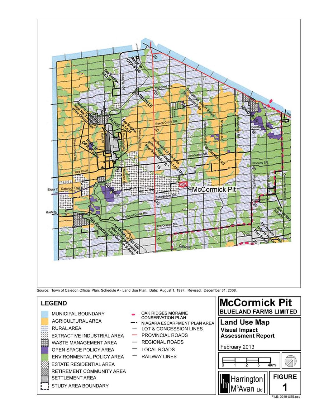
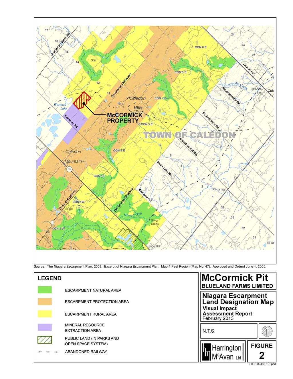
7 1.0 BACKGROUND The Niagara Escarpment Plan and the Town of Caledon Official Plan designate the subject property as Rural Area. See Figure 1 for the Land Use Map and Figure 2 for the Land Designation Map. One objective of this land designation from the Niagara Escarpment Plan is To maintain scenic values of lands in the vicinity of the Escarpment (1.5). As stated in the Town of Caledon Official Plan: The Town of Caledon will approve an application for an Official Plan Amendment to designate lands identified as Aggregate Resource Lands on Schedule L for a new extraction operation or expansion to an existing extraction operation when the following criteria have been met: e) the Applicant has completed a Visual Impact Report as described by Section and demonstrated that the proposal will not have any unacceptable impacts; And states: The Visual Impact Report required by Section (e) shall address the following: a) Assess the significant views and how they might be affected by the proposed extractive operation; b) Assess the changes to the natural landscape and the cultural landscape that would result from the operation; and c) Identification of any required mitigation measures, and the visual character of such measures. This may include berms, entrance designs, vegetation, landscaping, and operational matters such as small phases, screening of equipment, direction of extraction which would seek to minimize visual impacts. Therefore, in support of an Official Plan Amendment to allow a Category 1 Class A license, pit below water by Blueland Farms Limited, this visual impact assessment report has been prepared by Harrington McAvan Ltd. (formerly Harrington and Hoyle Ltd.) McCormick Pit 1 Supplementary Visual Impact Assessment Report Harrington McAvan Ltd. Blueland Farms Limited February 2013
8
9

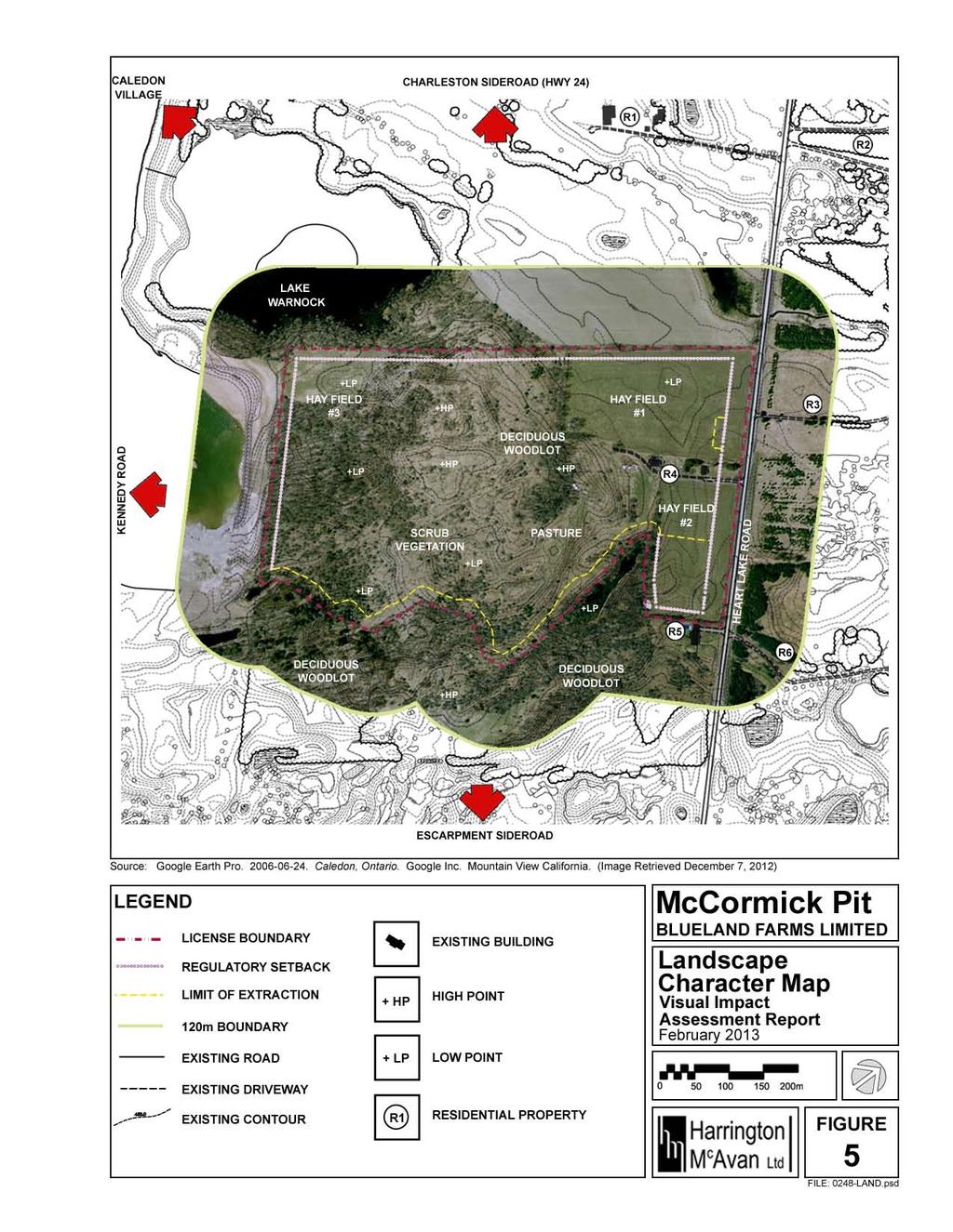
10 2.0 LOCATION The subject property is approximately 26 hectares (64 acres) in area and is located in the Niagara Escarpment on the west side of Heart Lake Road about 2 km east of Caledon Village in part of Lot 12, Concession 2 E.H.S., in the Town of Caledon, Regional Municipality of Peel. See Figure 3 for the Location Map. McCormick Pit Supplementary Visual Impact Assessment Report Blueland Farms Limited 4 Harrington McAvan Ltd. February 2013
11 3.0 METHODOLOGY The assessment process utilized for this study is based on Section of the Town of Caledon Official Plan. a) Assess the significant views and how they might be affected by the proposed extractive operation; b) Assess the changes to the natural landscape and the cultural landscape that would result from the operation; and c) Identification of any required mitigation measures, and the visual character of such measures. This may include berms, entrance designs, vegetation, landscaping, and operational matters such as small phases, screening of equipment, direction of extraction which would seek to minimize visual impacts. The process is also based on the Investigative Methods to Identify Change in the Landscape and Assessment of the Impact of Change on the Escarpment Environment provided in the Niagara Escarpment Commission Visual Assessment Guidelines. The methodology employed may be summarized into six stages: A. An inventory and analysis of the subject property. B. Field inventory. C. The identification and assessment of significant views and viewsheds. D. The identification and assessment of visual impacts. E. The development of mitigation measures. F. The assessment of the impact of change on the escarpment environment. A. An inventory and analysis of the subject property. An inventory and analysis of the existing landscape character. An inventory and analysis of the existing visual character, including the existing landscape evaluation. An inventory and analysis of neighbouring residences and roadways. B. Field inventory Completion of a field inventory and collection of a photographic record of the existing visual character of the subject property. McCormick Pit 5 Supplementary Visual Impact Assessment Report Harrington McAvan Ltd. Blueland Farms Limited February 2013
12 C. The identification and assessment of significant views and viewsheds. The identification and assessment of significant views and viewsheds. The views are assessed according to their features. Each feature in each view is evaluated separately according to its Picture Plane and its Control Points. Picture Plane The picture plane within which a feature sits influences its dominance in the picture, as well as its impact on the viewer. Scientific perspective is the relation of the size of an object and the distance from the observer. As the distance between the object and the viewer increases, the size of the object within the picture decreases. Foreground is the area of a picture or photo located closest to the viewer. This area is considered to be the most prominent picture plane. Due to the distance from the viewer, the features will appear to be close to their actual size in comparison to being in another picture plane. As a result, these features appear bold and distinct and will be first to be seen in the picture. Middleground is the area of a picture or photo located between the Foreground and the most distant part of the picture. This area is less prominent in a picture plane than the Foreground. Due to the distance from the viewer, the features will appear smaller than if it were in the Foreground. As a result, these features will appear less bold and less distinct than those in the Foreground and less attention will be paid towards them. Background is the area of a picture or photo located furthest from the viewer. This area is considered to be the most inconspicuous picture plane. Due to the distance from the viewer, the features will appear smaller than if they were in a different picture plane. As a result, these features are often faint and unnoticeable within the picture and little, if any, attention will be paid towards them. McCormick Pit 6 Supplementary Visual Impact Assessment Report Harrington McAvan Ltd. Blueland Farms Limited February 2013
13 Control Points The viewer and the feature are considered to be the control points of a line-of-sight. A feature s elevation in relation to that of the viewpoint influences its impact on the viewer. Viewer Superior defines a feature located at a lower elevation than the viewer. One would be looking down upon the feature as though controlling it. Features at this elevation impose no threat and their impact is negligible. Viewer Level defines a feature located at a similar elevation as the viewer. The feature s impact on the viewer will not be affected whatsoever. Viewer Inferior defines a feature located at a higher elevation than the viewer. This asserts the dominance of the feature. Depending on the type of feature, its impact may cause one to experience a sense of intimidation or to experience a sense of warmth and protection. Value The values of the features are based on their degree of uniqueness and significance in the view where: High Mod Low The feature provides a unique and significant experience to the overall landscape of the area. The features provide a unique or significant experience to the overall landscape of the surrounding area. The features provide neither a unique nor significant experience to the overall landscape of the surrounding area. D. The identification and assessment of visual impacts. The identification of the areas on the subject property affected by the features in each phase of the operations plan. The identification of significant views where the areas affected by the features in each phase of the operations plan are within or in direct proximity to the picture plane. The identification of any existing visual barriers in the areas affected by the features in each phase of the operations plan. The assessment of potential visual impacts of the feature in each phase of the operations plan on the significant views. Visual Impact The visual impacts of each phase of the operations plan are based on the degree and scale of which the existing landscape is affected. This will be determined taking into consideration any existing visual barriers, the feature s location in the picture plane, and the previously determined values of the views. The visual impacts in this report are assessed as follows: High feature will drastically modify the view Mod feature will neither drastically nor slightly modify the view Low feature will slightly modify the view McCormick Pit 7 Supplementary Visual Impact Assessment Report Harrington McAvan Ltd. Blueland Farms Limited February 2013
14 E. The development of mitigation measures. The identification of the features in each phase of the operations plan which may need to be screened from the significant views. The development of mitigation measures for each phase of the operations plan which will minimize impact on the Escarpment Environment upon completion of rehabilitation. F. The assessment of the impact of change on the escarpment environment. Review and assessment of impact on the existing landscape evaluation from the proposed end-use of the subject property. McCormick Pit 8 Supplementary Visual Impact Assessment Report Harrington McAvan Ltd. Blueland Farms Limited February 2013
15 4.0 LANDSCAPE CHARACTER 4.1 Context The subject property is approximately 26 hectares (64 acres) in area located on the west side of Heart Lake Road in part of Lot 12, Concession 2 E.H.S., in the Town of Caledon, Regional Municipality of Peel. Caledon Village is located about 2km west of the subject property and Bruce Trail runs along Escarpment Sideroad. Heart Lake Road does not serve to be a direct link or connection to other points of interest, so there will be no impact on the village visitors or the trail users. See Figure 3 for the Location Map. The subject property predominantly consists of rough pasture within the moraine and three hay fields along the northern perimeter of the subject property. A house, shed, and barn are located on the subject lands and another house is located on the small severed lot outside the eastern boundary of the subject property. 4.2 Vegetation The subject property is composed of three hay fields, a pasture, deciduous woodlots and scrub vegetation. The three hayfields are located in the northern, northeastern, and western ends of the property and the pasture holds the central portion of the land. The southern and eastern portions of the subject property are covered by deciduous woodlots, which form the skyline. Other areas of the moraine are covered by scattered scrub vegetation and younger trees. See Figure 5 for the Landscape Character Map. Species present on the subject property are Hawthorne, Black Cherry, Ash, Maple, Sumac, Scots Pine, Beech, Birch, Hemlock, Hop Hornbeam, Elm, Cherry, Dogwood, Poplar, Basswood, and Aspen. 4.3 Topography The hummocky topography consisting of steep sided knolls and enclosed depressions within the southern part of the subject property are in association with the Paris Moraine, with maximum topographical relief of approximately 20 metres. The hay fields are smooth to gently to moderately sloping within the area identified as an outwash deposit. 4.4 Drainage Based on observations, there are three small seasonal surface water bodies found within closed depressions on the subject property. The highly permeable, granular soils on the property allow fairly rapid infiltration, and as a result, there are no developed surface water drainage courses on the subject property. Surface drainage is mainly internal and directed to the low areas or depressions within the field and wooded areas, where water will infiltrate into the soils beneath. Located southwest of the house at Residence R5 is a large kettle depression that seasonally holds water. Warnock Lake, a provincially significant wetland, and Caledon Creek are located to the northwest and north of the subject property. 4.5 Land Use The lands to the northwest, north, northeast, and southeast of the subject property are mainly in agricultural use and/or open space. There are several farm and non-farm residences located along Heart Lake Road northeast of the subject property. See Figure 5 for the Landscape Character Map. The lands within the moraine to the south of the property are hummocky and McCormick Pit 9 Supplementary Visual Impact Assessment Report Harrington McAvan Ltd. Blueland Farms Limited February 2013
16 consist of old agricultural fields and meadows with scattered trees and shrubs. Southwest of the subject property the land is designated as Extractive Industrial Area and is currently licensed and operating. See Figure 1 for the Land Use Map. 4.6 Cultural Landscape Within the subject property sits a house shed, and barn that are located between Hay Field #1 and #2. On the small severed lot just outside the eastern corner of the subject property sits a small red brick house. Other buildings surrounding the proposed extraction area are located at residences R1, R2, R3, and R6. These properties are linked by Heart Lake Road. See Figure 5 for the Landscape Character Map. As mentioned earlier the lands to the west and southwest of the subject property are designated as Extractive Industrial Area. Therefore, large commercial gravel pits have historically been operated within the vicinity of Provincial Highways #10 and #24 near Caledon village to supply high quality aggregate to the Greater Toronto Area (GTA) markets. Examples of these gravel pits include the John McCormick Pit #17 in Lot 12, Concession 4 E.H.S., the Old Conn Smythe Pit #22 (now Regan Graham) in Concession 1 W.H.S., and the Caledon Sand and Gravel Pit #11 (now James Dick Construction) southwest of the subject property. See Figure 1 for the Land Use Map. McCormick Pit 10 Supplementary Visual Impact Assessment Report Harrington McAvan Ltd. Blueland Farms Limited February 2013
17
18


19 5.0 SIGNIFICANT VIEWS AND VIEWSHEDS Seven (7) views and viewsheds were assessed from different angles into the subject property from public roadways and neighbouring residences. See Figure 6 for the View Locations and Viewshed Map. 1. View Northwest at Residence R5 One traveling northwest on Heart Lake Road towards the entrance of Residence R5 would view Hay field #2 on the subject property through the deciduous trees. In this view the elevation appears to be constant, Heart Lake Road is the dominating feature in the Foreground, Residence R5 is less dominating in the Middleground, and Hay Field #2 is submissive. 2. Hay Field #2 Southeast of the house and sheds is a hay field composed of rolling hills. This area is surrounded by Scrub Vegetation to the southwest, Residence R5 to the southeast and a post and wire fence and Heart Lake Road to the northeast. Traveling southeast on Heart Lake Road Scrub Vegetation and a wooden privacy fence outline the open space of rolling hills. In this view the post and wire fence and tall grasses lie within the Foreground, but are not dominating or intimidating because they are Viewer Level. In the Middleground the elevation of Hay Field #2 fluctuates, but is relatively Viewer Level. The Scrub Vegetation in the Background is at a lower elevation than the rolling hills in the Middleground, yet still screens the view further into the subject property. McCormick Pit 13 Supplementary Visual Impact Assessment Report Harrington McAvan Ltd. Blueland Farms Limited February 2013


20 3. Hay Field #1 At the north end of the subject property is a flat existing hay field. The vegetation surrounding the open space screen the view further into the subject property and also focuses one s attention towards the vast hay field. The entrance to Residence R3 is located directly across Heart Lake Road from Hay Field #1. Therefore, someone exiting Residence R3 will be given no choice but to focus their attention towards this hay field. Located in the Foreground is Heart Lake Road. In the Middleground at Viewer Level lies Hay Field #1 and the Deciduous Woodlot and Scrub Vegetation sit in the Background. Although the woodlot and Scrub Vegetation is Viewer Inferior, it is at too far a distance from the viewer to impose a sense of intimidation or fear. 4. View South A good portion of the landscape character is captured in a view from the northern corner of the subject lands on Heart Lake Road. Our attention is immediately focused towards Hay Field #1 in the Foreground at Viewer Level. The Pasture sits Viewer Inferior in the Middleground. Although objects located at a higher elevation usually inflict a sense of warmth and encouraging dominance upon the viewer, the Pasture s location in the picture leaves it inferior to the vastness of the dominating hay field. Finally, in the Background, the Deciduous Woodlot stretches along the skyline. Similar to the Pasture, the woodlot is Viewer Inferior, however, the distance between the control points leaves it submissive in the landscape. McCormick Pit 14 Supplementary Visual Impact Assessment Report Harrington McAvan Ltd. Blueland Farms Limited February 2013


21 5. View Southeast Residence R1 is approximately 320m northwest of the subject property. This residence is located at a higher elevation than Hay Field #1 on the subject property. One travelling southeast on Heart Lake Road towards the McCormick Property would view Hay Field #1 on the subject property through the existing sparse vegetated screen at the property boundary. As a result, the subject property is Viewer Superior in the Background of this view. 6. View East There is a section of Kennedy Road that is at a higher elevation. From this point there is a view east towards the subject property. There is no form of a visual barrier restricting the view to only Kennedy Road. As a result, Kennedy Road sits in the Foreground of this picture. A hay field lies within the Middleground and there is a skyline view of a woodlot in the Background. This woodlot is located just outside of the subject lands. Although Hay Field #3 is located at the western corner of the subject property it will be hidden from view by the woodlot. McCormick Pit 15 Supplementary Visual Impact Assessment Report Harrington McAvan Ltd. Blueland Farms Limited February 2013

22 7. View Northeast The existing license operated by Caledon Sand and Gravel Inc. (now James Dick Construction) neighbours the subject property to the southwest. Mitigation measures have already been implemented to reduce the visual impacts of this extraction site. As a result, the subject property cannot currently be viewed from this location. Table 1 summarizes the assessment of the Significant Views. Each feature in each view is evaluated separately according to its Picture Plane and Control Points. Table 1. Summary of Significant Views View Description Feature Picture Plane Control Value Points 1 View Heart Lake Road Foreground Viewer Level Low Northwest at Residence R5 Middleground Viewer Level Low Residence R5 Hay Field #2 Background Viewer Level Moderate 2 Hay Field #2 Post Wire Fence Foreground Viewer Level Low Hay Field #2 Middleground Fluctuating High Deciduous Background Viewer Level Moderate Woodlot and Wetland 3 Hay Field #1 Heart Lake Road Foreground Viewer Level Low Hay Field #1 Middleground Viewer Level High Scrub Vegetation Background Viewer Inferior Low 4 View South Hay Field #1 Foreground Viewer Level High Pasture Middleground Viewer Inferior Moderate Deciduous Background Viewer Inferior Low Woodlot & Scrub Vegetation 5 View Subject Property Background Viewer Moderate Southeast Superior 6 View East Kennedy Road Foreground Viewer Level Low Hay Field Middleground Viewer High Superior Deciduous Background Viewer Low 7 View Northeast Woodlot Superior 30m Setback Foreground Viewer Level Low Seeded Berm Middleground Viewer Inferior Low McCormick Pit 16 Supplementary Visual Impact Assessment Report Harrington McAvan Ltd. Blueland Farms Limited February 2013
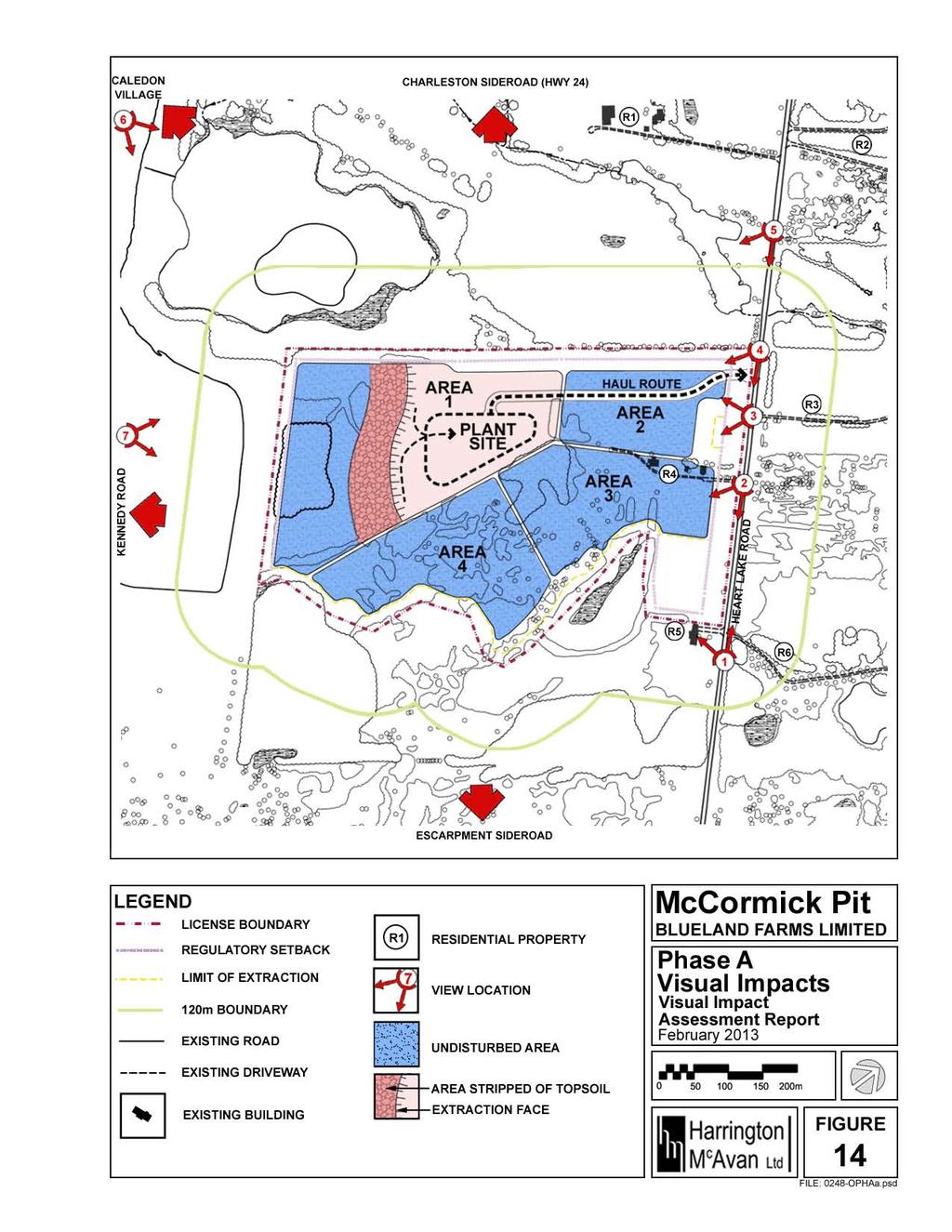
23 6.0 VISUAL IMPACTS The visual impacts of each phase of the operations plan are based on the degree and scale of which the existing landscape is affected by the operational features. This was determined taking into consideration existing visual barriers, the operational feature s location in the picture plane, and the view s previously determined value. The visual impacts in this report are assessed as follows: High feature will drastically modify the view Mod feature will neither drastically nor slightly modify the view Low feature will slightly modify the view 6.1 PHASE A During Phase A Areas 1 and 2 will be affected. The Haul Route will be running through Area 2 and 1. The Plant Site is located in Area 1 and extraction will begin in Area 1. A number of views already discussed are affected by this phase of the Operations Plan. See Figure 14. The following table summarizes the assessment of the Visual Impacts of Phase A on the significant views and viewsheds identified in this report. See Appendix I for the full assessment. Table 2. Summary of Phase A Visual Impacts Description Feature Area Existing Barrier Picture Plane Value Visual Impact 1 View Haul Route 2 Trees Background Mod Mod Northwest at Residence R5 2 Hay Field #2 None None None None None None 3 Hay Field #1 Haul Route 2 None Middleground High High Proposed Plant 1 Scrub Background Low Low Site Vegetation Extraction 1 Scrub Background Low Low Vegetation 4 View South Haul Route 2 Trees Foreground High High 5 View Southeast Proposed Plant Site 1 Woodlot and Scrub Vegetation Extraction 1 Woodlot and Scrub Vegetation Background Low Low Background Low Low Haul Route 2 Trees Background Mod Mod Proposed Plant 1 Woodlot Background Mod Low Site Extraction 1 Woodlot Background Mod Low 6 View East Extraction 1 Woodlot Background Low Low 7 View Northeast Extraction 1 Scrub Vegetation Background Mod Low McCormick Pit 17 Supplementary Visual Impact Assessment Report Harrington McAvan Ltd. Blueland Farms Limited February 2013
24
25 6.2 PHASE B During Phase B Areas 1 and 2 are affected. The Haul Route will be running through Area 2 where above water extraction will begin. The Plant Site is located in Area 1. Below water extraction and progressive rehabilitation are to take place in Area 1. A number of views already discussed are affected by this phase of the Operations Plan. See Figure 15. The following table summarizes the assessment of the Visual Impacts of Phase B on the significant views and viewsheds identified in this report. See Appendix I for the full assessment. Table 3. Summary of Phase B Visual Impacts Description Feature Area Existing Barrier 1 View Northwest at Residence R5 Picture Plane Value Visual Impact Haul Route 2 Trees Background Mod Mod Extraction 2 Trees Background Mod Mod 2 Hay Field #2 Extraction 2 None Peripheral Low Low 3 Hay Field #1 Haul Route 2 None Middleground High High Extraction 2 None Middleground High High Proposed Plant 1 Scrub Background Low Low Site Vegetation Extraction 1 Scrub Background Low Low Vegetation Rehabilitation 1 Scrub Background Low Low Vegetation 4 View South Haul Route 2 Trees Foreground High High 5 View Southeast Extraction 2 None Foreground High High Proposed Plant Site 1 Woodlot and Scrub Vegetation Extraction 1 Woodlot and Scrub Vegetation Rehabilitation 1 Woodlot and Scrub Vegetation Background Low Low Background Low Low Background Low Low Haul Route 2 Trees Background Mod Mod Extraction 2 Trees Background Mod Mod Proposed Plant 1 Woodlot Background Mod Low Site Extraction 1 Woodlot Background Mod Low Rehabilitation 1 Woodlot Background Mod Low 6 View East Rehabilitation 1 Woodlot Background Low Low 7 View Northeast Extraction 1 Woodlot Background Low Low Rehabilitation 1 Scrub Vegetation Extraction 1 Scrub Vegetation Background Mod Low Background Mod Low McCormick Pit 19 Supplementary Visual Impact Assessment Report Harrington McAvan Ltd. Blueland Farms Limited February 2013
26
27 6.3 PHASE C During Phase C Areas 1, 2 and 3 are affected. The Plant Site is located in Area 1. Progressive rehabilitation is to continue in Area 1. In Area 2 below water extraction is occurring and in Area 3 above water extraction is occurring. A number of views already discussed are affected in this phase of the Operations Plan. See Figure 16. The following table summarizes the assessment of the Visual Impacts of Phase C on the significant views and viewsheds identified in this report. See Appendix I for the full assessment. Table 4. Summary of Phase C Visual Impacts Description Feature Area Existing Barrier Picture Plane Value Visual Impact 1 View Extraction 3 Trees Background Mod Mod Northwest at Haul Route 2 Trees Background Mod Mod Residence R5 Extraction 2 Trees Background Mod Mod Rehabilitation 2 Trees Background Mod Mod 2 Hay Field #2 Extraction 3 None Middleground High High Extraction 2 None Peripheral Low Low Rehabilitation 2 None Peripheral Low Low 3 Hay Field #1 Haul Route 2 None Middleground High High Extraction 2 None Middleground High High Rehabilitation 2 None Middleground High High Proposed Plant 1 Scrub Background Low Low Site Vegetation Extraction 1 Scrub Background Low Low Vegetation Rehabilitation 1 Scrub Background Low Low Vegetation Extraction 3 None Background Low Low 4 View South Haul Route 2 Trees Foreground High High Extraction 2 None Foreground High High Rehabilitation 2 None Foreground High High Area Proposed Plant 1 Scrub Background Low Low Site Vegetation Extraction 1 Scrub Background Low Low Vegetation Rehabilitation 1 Scrub Background Low Low Vegetation Extraction 3 None Middleground Mod Mod McCormick Pit 21 Supplementary Visual Impact Assessment Report Harrington McAvan Ltd. Blueland Farms Limited February 2013
28 Table 4. Summary of Phase C Visual Impacts (cont d) Description Feature Area Existing Barrier Picture Plane Value Visual Impact 5 View Haul Route 2 Trees Background Mod Mod Southeast Extraction 2 Trees Background Mod Mod Rehabilitation 2 Trees Background Mod Mod Proposed Plant 1 Woodlot Background Mod Low Site Extraction 1 Woodlot Background Mod Low Rehabilitation 1 Woodlot Background Mod Low Extraction 3 Trees Background Mod Low 6 View East Rehabilitation 1 Woodlot Background Low Low 7 View Northeast Extraction 1 Woodlot Background Low Low Rehabilitation 1 Scrub Vegetation Extraction 1 Scrub Vegetation Background Mod Low Background Mod Low McCormick Pit 22 Supplementary Visual Impact Assessment Report Harrington McAvan Ltd. Blueland Farms Limited February 2013
29
30 6.4 PHASE D During Phase D Areas 1, 2, 3 and 4 are affected. The Plant Site is located in Area 1. Rehabilitation is to continue in Area 1. Extraction is to be completed and rehabilitation is to continue in Area 2, rehabilitation and extraction will take place in Area 3, and extraction will begin in Area 4. A number of views already discussed are affected by this phase of the Operations Plan. See Figure 17. The following table summarizes the assessment of the Visual Impacts of Phase D on the significant views and viewsheds identified in this report. See Appendix I for the full assessment. Table 5. Summary of Phase D Visual Impacts Description Feature Area Existing Barrier Picture Plane Value Visual Impact 1 View Extraction 3 Trees Background Mod Mod Northwest at Rehabilitation 3 Trees Background Mod Mod Residence R5 Haul Route 2 Trees Background Mod Mod Rehabilitation 2 Trees Background Mod Mod 2 Hay Field #2 Extraction 3 None Middleground High High Rehabilitation 3 None Middleground High High Extraction 4 Scrub Background Low Low Vegetation Rehabilitation 2 None Peripheral Low Low 3 Hay Field #1 Haul Route 2 None Middleground High High Rehabilitation 2 None Middleground High High Proposed Plant 1 Scrub Background Low Low Site Vegetation Rehabilitation 1 Scrub Background Low Low Vegetation Extraction 3 None Background Low Low Rehabilitation 3 None Background Low Low Extraction 4 Woodlot Background Low Low and Scrub Vegetation 4 View South Haul Route 2 Trees Foreground High High Rehabilitation 2 None Foreground High High Extraction 4 None Background Low Low Proposed Plant Site 1 Woodlot and Scrub Vegetation Rehabilitation 1 Woodlot and Scrub Vegetation Background Low Low Background Low Low Extraction 3 None Middleground Mod Mod Rehabilitation 3 None Middleground Mod Mod McCormick Pit 24 Supplementary Visual Impact Assessment Report Harrington McAvan Ltd. Blueland Farms Limited February 2013
31 Table 5. Summary of Phase D Visual Impacts (cont d) Description Feature Area Existing Barrier Picture Plane Value Visual Impact 5 View Haul Route 2 Trees Background Mod Mod Southeast Rehabilitation 2 Trees Background Mod Mod Proposed Plant 1 Woodlot Background Mod Low Site Rehabilitation 1 Woodlot Background Mod Low Extraction 3 Trees Background Mod Low Rehabilitation 3 Trees Background Mod Low Extraction 4 Woodlot Background Mod Low 6 View East Rehabilitation 1 Woodlot Background Low Low 7 View Northeast Rehabilitation 1 Scrub Vegetation Extraction 4 Scrub Vegetation Background Mod Low Background Mod Low McCormick Pit 25 Supplementary Visual Impact Assessment Report Harrington McAvan Ltd. Blueland Farms Limited February 2013
32
33 6.5 PHASE E During Phase E Areas 1, 2, 3 and 4 are affected. The Plant Site is located in Area 1 and the Haul Route is located in Area 2. Rehabilitation will be completed in Area 3 and extraction and rehabilitation will continue in Area 4. A number of views already discussed are affected by this phase of the Operations Plan. See Figure 18. The following table summarizes the assessment of the Visual Impacts of Phase E on the significant views and viewsheds identified in this report. See Appendix I for the full assessment. Table 6. Summary of Phase E Visual Impacts Description Feature Area Existing Barrier 1 View Northwest at Residence R5 Picture Plane Value Visual Impact Rehabilitation 3 Trees Background Mod Mod Haul Route 2 Trees Background Mod Mod 2 Hay Field #2 Rehabilitation 3 None Middleground High High Extraction 4 Scrub Background Mod Mod Vegetation Rehabilitation 4 Scrub Background Mod Mod Vegetation 3 Hay Field #1 Haul Route 2 None Middleground High High Proposed Plant 1 Scrub Background Low Low Site Vegetation Rehabilitation 3 None Background Low Low Extraction 4 Scrub Background Low Low Vegetation Rehabilitation 4 Scrub Background Low Low Vegetation 4 View South Haul Route 2 Trees Foreground High High 5 View Southeast Rehabilitation 4 None Background Low Low Extraction 4 None Background Low Low Proposed Plant Site 1 Woodlot and Scrub Vegetation Background Low Low Rehabilitation 3 None Middleground Mod Mod Haul Route 2 Trees Background Mod Mod Proposed Plant 1 Woodlot Background Mod Low Site Extraction 4 Woodlot Background Mod Low Rehabilitation 4 Woodlot Background Mod Low Rehabilitation 3 Trees Background Mod Low 6 View East None None None None None None 7 View Northeast Extraction 4 Scrub Vegetation Rehabilitation 4 Scrub Vegetation Background Mod Low Background Mod Low McCormick Pit 27 Supplementary Visual Impact Assessment Report Harrington McAvan Ltd. Blueland Farms Limited February 2013
34
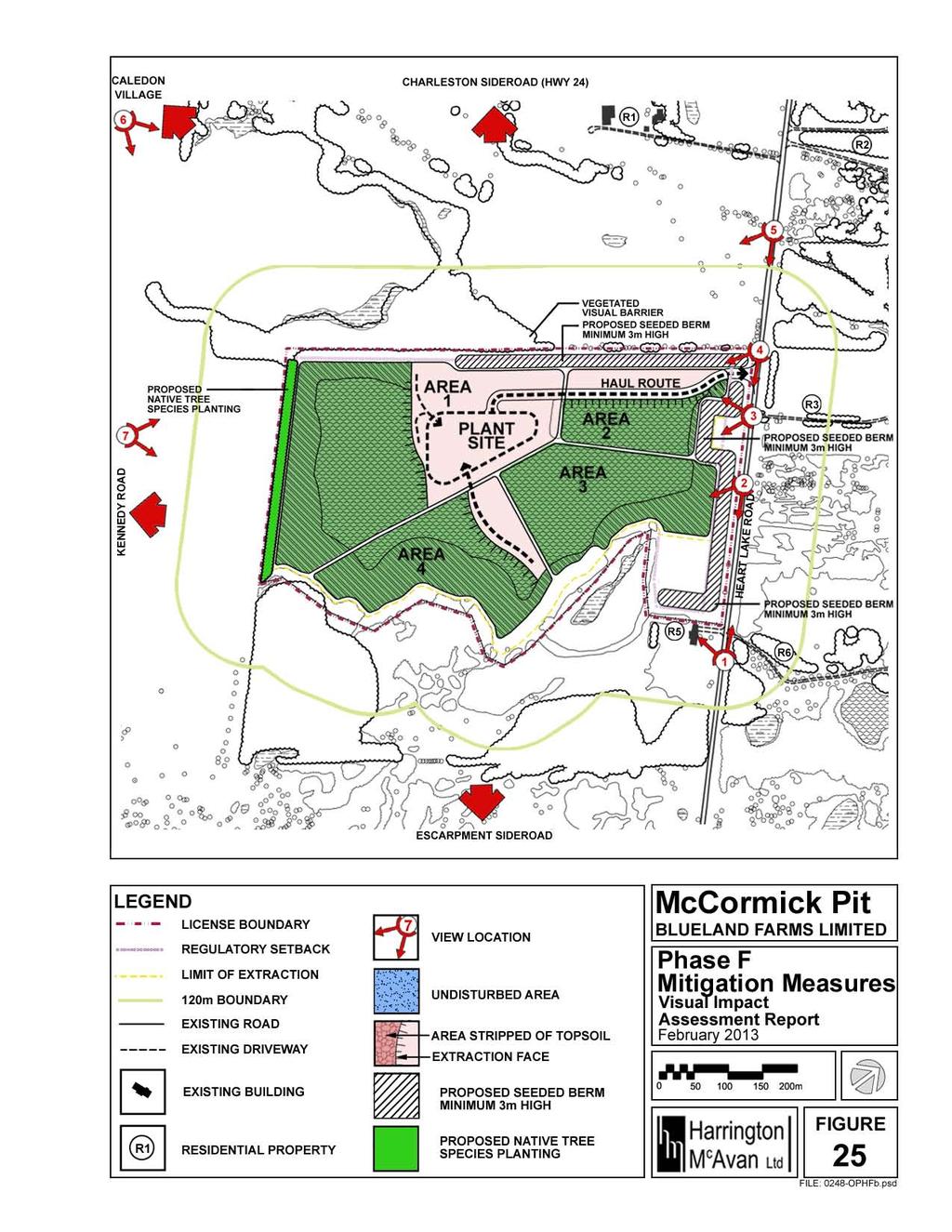
35 6.6 PHASE F During Phase F Area 1, 2, and 4 are affected. The Plant Site is located in Area 1. The Haul Route is located in Area 2. Extraction and Rehabilitation are to be completed in Area 4. Rehabilitation of sideslopes along the perimeter of the pond is to be completed and all equipment, scraps and machinery from Area 1 are to be removed from the subject property. Rehabilitation of the Haul Route and Plant Site are to occur. A number of views already discussed are affected by this phase of the Operations Plan. See Figure 19. The following table summarizes the assessment of the Visual Impacts of Phase F on the views and viewsheds identified in this report. See Appendix I for the full assessment. Table 7. Summary of Phase F Visual Impacts Description Feature Area Existing Barrier Picture Plane Value Visual Impact 1 View Haul Route 2 Trees Background Mod Mod Northwest at Residence R5 2 Hay Field #2 Extraction 4 Scrub Background Mod Mod Rehabilitation 4 Scrub Background Mod Mod 3 Hay Field #1 Haul Route 2 None Middleground High High Proposed Plant Site 1 Woodlot and Scrub Vegetation Extraction 4 Woodlot and Scrub Vegetation Rehabilitation 4 Woodlot and Scrub Vegetation Background Low Low Background Low Low Background Low Low 4 View South Haul Route 2 Trees Foreground High High Extraction 4 Woodlot and Scrub Vegetation Rehabilitation 4 Woodlot and Scrub Proposed Plant Site Vegetation 1 Woodlot and Scrub Vegetation Background Low Low Background Low Low Background Low Low 5 View Haul Route 2 Trees Background Mod Mod Southeast Proposed Plant 1 Woodlot Background Mod Low Site Extraction 4 Woodlot Background Mod Low Rehabilitation 4 Woodlot Background Mod Low 6 View East None None None None None None 7 View Northeast Extraction 4 Scrub Vegetation Rehabilitation 4 Scrub Vegetation Background Mod Low Background Mod Low McCormick Pit 29 Supplementary Visual Impact Assessment Report Harrington McAvan Ltd. Blueland Farms Limited February 2013
36
37 6.7 PHASE G During Phase G Area 1 and 2 are affected. Below water extraction and rehabilitation are to be completed in Area 1 and 2. Rehabilitation of the side slopes along the perimeter of the pond is to be completed. Upon completion of extraction all equipment, structures, scraps and machinery will be removed from the site and all haul roads and the plant site will be rehabilitated. A number of views already discussed are affected by this phase of operations. The following table summarizes the assessment of the Visual Impacts of Phase G on the views and viewsheds identified in this report. See Appendix I for the full assessment. Table 8. Summary of Phase G Visual Impacts Description Feature Area Existing Barrier Picture Plane Value Visual Impact 1 View Haul Route 2 Trees Background Mod Mod Northwest at Extraction 2 Trees Background Mod Mod Residence R5 Rehabilitation 2 Trees Background Mod Mod 2 Hay Field #2 None None None None None None 3 Hay Field #1 Haul Route 2 None Middleground High High Proposed Plant 1 None Background Low Mod Site Extraction 2 None Middleground High High Rehabilitation 2 None Middleground High High Extraction 1 Woodlot/ Background Low Mod Scrub Veg Rehabilitation 1 Woodlot/ Background Low Mod Scrub Veg 4 View South Haul Route 2 Trees Foreground High High Extraction 2 Trees Foreground High High Rehabilitation 2 Trees Foreground High High Extraction 1 Woodlot/ Background Low Mod Scrub Veg Rehabilitation 1 Woodlot/ Background Low Mod Scrub Veg Proposed Plant 1 Woodlot/ Background Low Mod Site Scrub Veg 5 View Haul Route 2 Trees Background Mod Mod Southeast Proposed Plant 1 Woodlot Background Mod Low Site Extraction 2 Trees Background Mod Mod Rehabilitation 2 Trees Background Mod Mod Extraction 1 Woodlot Background Mod Low Rehabilitation 1 Woodlot Background Mod Low 6 View East None None None None None None 7 View Northeast Extraction 1 Scrub Vegetation Rehabilitation 1 Scrub Vegetation Background Mod Low Background Mod Low McCormick Pit 31 Supplementary Visual Impact Assessment Report Harrington McAvan Ltd. Blueland Farms Limited February 2013
38 7.0 MITIGATION MEASURES As stated in the Niagara Escarpment Plan: 2.11 Mineral Resources 3. As a condition of the license the extractive operation shall be screened while it is in progress and, where possible, prior to extraction in a manner compatible with the surrounding visual environment. 4. Screening shall incorporate the following: a) Overburden material supplemented with native tree and shrub plantings should be utilized for screening purposes. b) Tree screen plantings are to be of compatible species and sizes to permit only very limited visual contact from the surrounding landscape. c) All plantings should be properly maintained to ensure continue survival and good growth rates. d) Where the existing forest is adequate to be considered as an effective screen along the perimeter of the site, no additional artificial berming or stockpiling of overburden materials will be permitted within the forested area being used as a natural screen. Therefore, the following mitigation measures are being recommended by Harrington McAvan Ltd. (formerly Harrington and Hoyle Ltd.) for the proposed operations on the subject lands. McCormick Pit 32 Supplementary Visual Impact Assessment Report Harrington McAvan Ltd. Blueland Farms Limited February 2013
39 7.1 PHASE A During Phase A Areas 1 and 2 will be affected. The Haul Route will be running through Area 2 and 1. The Plant Site is located in Area 1 and extraction will begin in Area 1. A number of visual impacts have been discussed. These impacts may be minimized with the recommended mitigation measures. See Figure 20. The following table summarizes the views impacted by the operations of Phase A, the features affecting the views, the grounds affected in the views, the previously determined values and visual impacts, and the recommended mitigation measures for the visual impacts. See Appendix II for the development of these recommended mitigation measures. Table 9. Summary of Phase A Mitigation Measures Description Feature Picture Value Visual Mitigation Measure Plane Impact 1 View Northwest at Haul Route Background Mod Mod Installation of seeded Residence R5 3 Hay Field #1 Haul Route Middleground High High Installation of seeded Proposed Plant Site Background Low Low Installation of seeded Extraction Area 1 Background Low Low Installation of seeded 4 View South Haul Route Foreground High High Installation of seeded Proposed Plant Site Background Low Low Installation of seeded Extraction Area 1 Background Low Low Installation of seeded 5 View Southeast Haul Route Background Mod Mod Installation of seeded Proposed Plant Site Background Mod Low Installation of seeded Extraction Area 1 Background Mod Low Installation of seeded 6 View East Extraction Area 1 Background Low Low Installation of native deciduous and 7 View Northeast Extraction Area 1 coniferous tree species Background Mod Low Installation of native deciduous and coniferous tree species McCormick Pit 33 Supplementary Visual Impact Assessment Report Harrington McAvan Ltd. Blueland Farms Limited February 2013
40
41 7.2 PHASE B During Phase B Areas 1 and 2 are affected. The Haul Route will be running through Area 2 where above water extraction will begin. The Plant Site is located in Area 1. Below water extraction and progressive rehabilitation are to take place in Area 1. A number of visual impacts have been discussed. These impacts may be minimized with the recommended mitigation measures. See Figure 21. The following table summarizes the views impacted by the operations of Phase B, the features affecting the views, the grounds affected in the views, the previously determined values and visual impacts, and the recommended mitigation measures for the visual impacts. See Appendix II for the development of these recommended mitigation measures. Table 10. Summary of Phase B Mitigation Measures Description Feature Picture Value Visual Mitigation Measure Plane Impact 1 View Northwest at Haul Route Background Mod Mod Installation of seeded Residence R5 Extraction Area 2 Background Mod Mod Installation of seeded 2 Hay Field #2 Extraction Area 2 Peripheral Low Low Installation of seeded 3 Hay Field #1 Haul Route Middleground High High Installation of seeded Extraction Area 2 Middleground High High Installation of seeded Proposed Plant Site Background Low Low Installation of seeded Rehabilitation & Extraction Background Low Low Installation of seeded Area 1 4 View South Haul Route Foreground High High Installation of seeded Extraction Area 2 Foreground High High Installation of seeded Proposed Background Low Low Installation of seeded 5 View Southeast Plant Site Rehabilitation & Extraction Area 1 Background Low Low Installation of seeded Haul Route Background Mod Mod Installation of seeded Extraction Area 2 Background Mod Mod Installation of seeded Proposed Plant Site Background Mod Low Installation of seeded Rehabilitation & Extraction Area 1 Background Mod Low Installation of seeded McCormick Pit 35 Supplementary Visual Impact Assessment Report Harrington McAvan Ltd. Blueland Farms Limited February 2013
42 Table 10. Summary of Phase B Mitigation Measures (cont d) Description Feature Picture Value Visual Mitigation Measure Plane Impact 6 View East Rehabilitation & Extraction Area 1 Background Low Low Installation of native deciduous and coniferous tree 7 View Northeast Rehabilitation & Extraction Area 1 species Background Mod Low Installation of native deciduous and coniferous tree species McCormick Pit 36 Supplementary Visual Impact Assessment Report Harrington McAvan Ltd. Blueland Farms Limited February 2013
43
44 7.3 PHASE C During Phase C Areas 1, 2 and 3 are affected. The Plant Site is located in Area 1. Progressive rehabilitation is to continue in Area 1. In Area 2 below water extraction is occurring and in Area 3 above water extraction is occurring. A number of visual impacts have been discussed. These impacts may be minimized with the recommended mitigation measures. See Figure 22. The following table summarizes the views impacted by the operations of Phase C, the features affecting the views, the grounds affected in the views, the previously determined values and visual impacts, and the recommended mitigation measures for the visual impacts. See Appendix II for the development of these recommended mitigation measures. Table 11. Summary of Phase C Mitigation Measures Description Feature Picture Value Visual Mitigation Measure Plane Impact 1 View Northwest at Extraction Area 3 Background Mod Mod Installation of seeded Residence R5 Haul Route Background Mod Mod Installation of seeded Rehabilitation and Extraction Background Mod Mod Installation of seeded Area 2 2 Hay Field #2 Extraction Middleground High High Installation of seeded Area 3 Rehabilitation and Extraction Area 2 Peripheral Low Low Installation of seeded 3 Hay Field #1 Haul Route Middleground High High Installation of seeded Rehabilitation and Extraction Area 2 Middleground High High Installation of seeded Proposed Plant Site Rehabilitation and Extraction Area 1 Background Low Low Installation of seeded Background Low Low Installation of seeded Extraction Area 3 Background Low Low Installation of seeded 4 View South Haul Route Foreground High High Installation of seeded Rehabilitation and Extraction Area 2 Foreground High High Installation of seeded Proposed Plant Site Rehabilitation and Extraction Area 1 Extraction Area 3 Background Low Low Installation of seeded Background Low Low Installation of seeded Middleground Mod Mod Installation of seeded McCormick Pit 38 Supplementary Visual Impact Assessment Report Harrington McAvan Ltd. Blueland Farms Limited February 2013
45 Table 11. Summary of Phase C Mitigation Measures (cont d) Description Feature Picture Value Visual Mitigation Measure Plane Impact 4 View South Haul Route Foreground High High Installation of seeded Rehabilitation and Extraction Foreground High High Installation of seeded Area 2 Proposed Background Low Low Installation of seeded 5 View Southeast Plant Site Rehabilitation and Extraction Area 1 Background Low Low Installation of seeded Extraction Area 3 Middleground Mod Mod Installation of seeded Haul Route Background Mod Mod Installation of seeded Rehabilitation Background Mod Mod Installation of seeded and Extraction Area 2 Proposed Plant Site Rehabilitation and Extraction Area 1 Extraction Area 3 6 View East Rehabilitation and Extraction Area 1 7 View Northeast Rehabilitation and Extraction Area 1 Background Mod Low Installation of seeded Background Mod Low Installation of seeded Background Mod Low Installation of seeded Background Low Low Installation of native deciduous and coniferous tree species Background Mod Low Installation of native deciduous and coniferous tree species McCormick Pit 39 Supplementary Visual Impact Assessment Report Harrington McAvan Ltd. Blueland Farms Limited February 2013
46
47 7.4 PHASE D During Phase D Areas 1, 2, 3 and 4 are affected. The Plant Site is located in Area 1 where rehabilitation is to continue. Extraction is to be completed and rehabilitation is to continue in Area 2, rehabilitation and extraction will take place in Area 3, and extraction will begin in Area 4. A number of visual impacts have been discussed. These impacts may be minimized with the recommended mitigation measures. See Figure 23. The following table summarizes the views impacted by the operations of Phase D, the features affecting the views, the grounds affected in the views, the previously determined values and visual impacts, and the recommended mitigation measures for the visual impacts. See Appendix II for the development of these recommended mitigation measures. Table 12. Summary of Phase D Mitigation Measures Description Feature Picture Plane Value Landscape Views 1 View Rehabilitation Northwest at and Extraction Residence R5 Area 3 2 Hay Field #2 Rehabilitation and Extraction Area 3 Visual Impact Mitigation Measure Background Mod Mod Installation of seeded Haul Route Background Mod Mod Installation of seeded Rehabilitation Area 2 Background Mod Mod Installation of seeded Middleground High High Installation of seeded Extraction Area 4 Background Low Low Installation of seeded Rehabilitation Area 2 Peripheral Low Low Installation of seeded 3 Hay Field #1 Haul Route Middleground High High Installation of seeded Rehabilitation Area 2 Middleground High High Installation of seeded Proposed Plant Site Background Low Low Installation of seeded Rehabilitation Area 1 Background Low Low Installation of seeded Rehabilitation and Extraction Area 3 Background Low Low Installation of seeded Extraction Area 4 Background Low Low Installation of seeded McCormick Pit 41 Supplementary Visual Impact Assessment Report Harrington McAvan Ltd. Blueland Farms Limited February 2013
48 Table 12. Summary of Phase D Mitigation Measures (cont d) Description Feature Picture Value Visual Mitigation Measure Plane Impact Landscape Views 4 View South Haul Route Foreground High High Installation of seeded Rehabilitation Area 2 Foreground High High Installation of seeded Extraction Area 4 Background Low Low Installation of seeded Proposed Background Low Low Installation of seeded 5 View Southeast Plant Site Rehabilitation and Extraction Area 1 Rehabilitation and Extraction Area 3 Background Low Low Installation of seeded Middleground Mod Mod Installation of seeded Haul Route Background Mod Mod Installation of seeded Rehabilitation Area 2 Background Mod Mod Installation of seeded Proposed Plant Site Background Mod Low Installation of seeded Rehabilitation and Extraction Area 1 Background Mod Low Installation of seeded Rehabilitation and Extraction Area 3 Extraction Area 4 6 View East Rehabilitation Area 1 7 View Northeast Rehabilitation Area 1 Extraction Area 4 Background Mod Low Installation of seeded Background Mod Low Installation of seeded Background Low Low Installation of native deciduous and coniferous tree species Background Mod Low Installation of native deciduous and coniferous tree species Background Mod Low Installation of native deciduous and coniferous tree species McCormick Pit 42 Supplementary Visual Impact Assessment Report Harrington McAvan Ltd. Blueland Farms Limited February 2013
49
50 7.5 PHASE E During Phase E Areas 1, 2, 3 and 4 are affected. The Plant Site is located in Area 1 and the Haul Route is located in Area 2. Rehabilitation will be completed in Area 3 and extraction and rehabilitation will continue in Area 4. A number of visual impacts have been discussed. These impacts may be minimized with the recommended mitigation measures. See Figure 24. The following table summarizes the views impacted by the operations of Phase E, the features affecting the views, the grounds affected in the views, the previously determined values and visual impacts, and the recommended mitigation measures for the visual impacts. See Appendix II for the development of these recommended mitigation measures. Table 13. Summary of Phase E Mitigation Measures Description Feature Picture Value Visual Mitigation Measure Plane Impact 1 View Northwest at Rehabilitation Area 3 Background Mod Mod Installation of seeded Residence R5 Haul Route Background Mod Mod Installation of seeded 2 Hay Field #2 Rehabilitation Area 3 Middleground High High Installation of seeded Rehabilitation and Extraction Background Mod Mod Installation of seeded Area 4 3 Hay Field #1 Haul Route Middleground High High Installation of seeded Proposed Plant Site Background Low Low Installation of seeded Rehabilitation Background Low Low Installation of seeded Area 3 Rehabilitation and Extraction Area 4 Background Low Low Installation of seeded 4 View South Haul Route Foreground High High Installation of seeded Rehabilitation and Extraction Area 4 Background Low Low Installation of seeded 5 View Southeast Proposed Plant Site Background Low Low Installation of seeded Rehabilitation Area 3 Middleground Mod Mod Installation of seeded Haul Route Background Mod Mod Installation of seeded Proposed Background Mod Low Installation of seeded Plant Site Rehabilitation Background Mod Low Installation of seeded Area 3 Rehabilitation Background Mod Low Installation of seeded and Extraction Area 4 McCormick Pit 44 Supplementary Visual Impact Assessment Report Harrington McAvan Ltd. Blueland Farms Limited February 2013
51 Table 13. Summary of Phase E Mitigation Measures (cont d) Description Feature Picture Plane Value Visual Impact 7 View Northeast Rehabilitation and Extraction Area 4 Mitigation Measure Background Mod Low Installation of native deciduous and coniferous tree species McCormick Pit 45 Supplementary Visual Impact Assessment Report Harrington McAvan Ltd. Blueland Farms Limited February 2013
52
53 7.6 PHASE F During Phase F Areas 1, 2, and 4 are affected. The Plant Site is located in Area 1. The Haul Route is located in Area 2. Extraction and Rehabilitation are to be completed in Area 4. Rehabilitation of sideslopes along the perimeter of the pond is to be completed and all equipment, scraps and machinery from Area 1 are to be removed from the subject property. Rehabilitation of the Haul Route and Plant Site are to occur. A number of visual impacts have been discussed. These impacts may be minimized with the recommended mitigation measures. See Figure 25. The following table summarizes the views impacted by the operations of Phase F, the features affecting the views, the grounds affected in the views, the previously determined values and visual impacts, and the recommended mitigation measures for the visual impacts. See Appendix II for the development of these recommended mitigation measures. Table 14. Summary of Phase F Mitigation Measures Description Feature Picture Plane Value 1 View Northwest at Residence R5 2 Hay Field #2 Rehabilitation and Extraction Area 4 Visual Mitigation Measure Impact Haul Route Background Mod Mod Installation of seeded Background Mod Mod Installation of seeded 3 Hay Field #1 Haul Route Middleground High High Installation of seeded Proposed Plant Site Background Low Low Installation of seeded Rehabilitation and Extraction Area 4 Background Low Low Installation of seeded 4 View South Haul Route Foreground High High Installation of seeded Rehabilitation and Extraction Area 4 Background Low Low Installation of seeded 5 View Southeast 7 View Northeast Proposed Plant Site Background Low Low Installation of seeded Haul Route Background Mod Mod Installation of seeded Proposed Background Mod Low Installation of seeded Plant Site Rehabilitation Background Mod Low Installation of seeded and Extraction Area 4 Rehabilitation and Extraction Area 4 Background Mod Low Installation of native deciduous and coniferous tree species McCormick Pit 47 Supplementary Visual Impact Assessment Report Harrington McAvan Ltd. Blueland Farms Limited February 2013
54
55 7.7 PHASE G During Phase G Area 1 and 2 are affected. Below water extraction and rehabilitation are to be completed in Area 1 and 2. Rehabilitation along the perimeter of the pond is to be completed. Upon completion of extraction all equipment, structures, scraps and machinery will be removed from the site. All haul roads and the plant site will be rehabilitated. A number of visual impacts have been discussed and can be minimized with recommended mitigation measures. The following table summarizes the views impacted by the operations of Phase G, the features affecting the views, the grounds affected in the views, the previously determined values and visual impacts, and the recommended mitigation measures for the visual impacts. See Appendix II for the development of these recommended mitigation measures. Table 15. Summary of Phase G Mitigation Measures Description Feature Picture Value Visual Mitigation Measure Plane Impact 1 View Northwest at Residence R5 Haul Route Background Mod Mod Installation of seeded Rehabilitation and Extraction Area 2 Background Mod Mod Installation of seeded 3 Hay Field #1 Haul Route Middleground High High Installation of seeded Proposed Plant Site Background Low Mod Installation of seeded Rehabilitation and Extraction Area 2 Middleground High High Installation of seeded Rehabilitation and Extraction Area 1 Background Low Mod Installation of seeded 4 View South Haul Route Foreground High High Installation of seeded Rehabilitation and Extraction Area 2 Foreground High High Installation of seeded 5 View Southeast Rehabilitation and Extraction Area 1 Background Low Mod Installation of seeded Proposed Plant Site Background Low Mod Installation of seeded Haul Route Background Mod Mod Installation of seeded Proposed Background Mod Low Installation of seeded Plant Site Rehabilitation Background Mod Mod Installation of seeded and Extraction Area 2 Rehabilitation and Extraction Area 1 Background Mod Low Installation of seeded McCormick Pit 49 Supplementary Visual Impact Assessment Report Harrington McAvan Ltd. Blueland Farms Limited February 2013
56 Table 15. Summary of Phase G Mitigation Measures (cont d) Description Feature Picture Plane Value Visual Impact 7 View Northeast Rehabilitation and Extraction Area 1 Mitigation Measure Background Mod Low Installation of native deciduous and coniferous tree species McCormick Pit 50 Supplementary Visual Impact Assessment Report Harrington McAvan Ltd. Blueland Farms Limited February 2013

57 7.8 SUMMARY The recommended mitigation measures were assessed to ensure the proposed pit operations on the subject property would not be viewed from the vantage points identified in this report. This review was enabled by line of sight cross sections and photographic simulations. A 60 cone of vision was used for the line of sight cross sections to determine the field of vision with and without mitigation measures. In summary, the recommended mitigation measures are proposed to be implemented prior to operations taking place in the following phases: Phase A (See Figure 20 for Phase A - Mitigation Measures) 1. Install a seeded berm minimum 3m high within the northwestern regulatory setback adjacent to Area 2. View #5 (View Southeast) is from Heart Lake Road towards the McCormick Property. A temporary acoustical berm maximum 8m in height has been included in the proposal in this location for noise attenuation. In the line of sight cross section the proposed acoustical berm is approximately 3m in height. At this height the proposed temporary seeded acoustical berm will be sufficient to also serve as a visual barrier to screen the view of the proposed pit floor and operations. Figure 26. View #5: Line of Sight Cross Section McCormick Pit 51 Supplementary Visual Impact Assessment Report Harrington McAvan Ltd. Blueland Farms Limited February 2013
 Figure 28.")
58 The subject property sits Viewer Superior in the background of this view. As a result the proposed temporary seeded acoustical berms are not a dominant feature in the picture plane. Figure 27. Existing View Southeast (View #5) Figure 28. View Southeast (View #5) with proposed temporary seeded acoustical berm McCormick Pit 52 Supplementary Visual Impact Assessment Report Harrington McAvan Ltd. Blueland Farms Limited February 2013
 is from the entrance to Residence R3 across Heart Lake Road towards Hay Field #1.")
59 2. Install a seeded berm minimum 3m high within the northeastern regulatory setback adjacent to Area 2. View #3 (Hay Field #1) is from the entrance to Residence R3 across Heart Lake Road towards Hay Field #1. An acoustical berm ranging in height from 4 to 7m has been included in the proposal in this location for noise attenuation. In the line of sight cross section for this view the proposed acoustical berm is approximately 6m in height. At this height the proposed temporary seeded acoustical berm will be more than sufficient to also serve as a visual barrier to screen the view of the proposed pit floor and operations. Figure 29. View #3: Line of Sight Cross Section McCormick Pit 53 Supplementary Visual Impact Assessment Report Harrington McAvan Ltd. Blueland Farms Limited February 2013
 with proposed temporary seeded acoustical berm McCormick Pit 54 Supplementary Visual Impact")
60 Figure 30. Existing View of Hay Field #1 (View #3) Figure 31. View of Hay Field #1 (View #3) with proposed temporary seeded acoustical berm McCormick Pit 54 Supplementary Visual Impact Assessment Report Harrington McAvan Ltd. Blueland Farms Limited February 2013
 is from Kennedy Road looking over towards the subject property.")
61 3. Install native deciduous and coniferous tree species within the southwestern regulatory setback adjacent to Area 1. View #7 (View Northeast) is from Kennedy Road looking over towards the subject property. Mitigation measures for the existing licence to the southwest of the subject property have already been implemented, and, as a result, the subject property cannot currently be viewed from this location. However, it cannot be assumed that these mitigation measures will remain in place until completion of operations of the subject property. Therefore, this tree screen is recommended to be installed prior to operations commencing in Area 1. Phase B (See Figure 21 for Phase B - Mitigation Measures) 4. Install a seeded berm minimum 3m high within the regulatory setback adjacent to the northwestern property line of Residence R5 to reinforce the existing tree screen. View #1 (View Northwest at Residence R5) is from Heart Lake Road at the entrance of Residence R5 towards Hay Field #2 on the subject property. An acoustical berm maximum 7m in height has been included in the proposal in this location for noise attenuation. In the line of sight cross section the proposed acoustical berm is approximately 3m in height. At this height the proposed temporary seeded acoustical berm is sufficient to also serve as a visual barrier to screen the view of the proposed pit floor and operations. Figure 32. View #1: Line of Sight Cross Section McCormick Pit 55 Supplementary Visual Impact Assessment Report Harrington McAvan Ltd. Blueland Farms Limited February 2013

 Figure 34.")


62 Figure 33. Existing View Northwest at Residence R5 (View #1) Figure 34. View Northwest at Residence R5 (View #1) with proposed temporary seeded acoustical berm McCormick Pit 56 Supplementary Visual Impact Assessment Report Harrington McAvan Ltd. Blueland Farms Limited February 2013
 is from the existing driveway into the subject property towards Hay Field #2.")
63 Phase C (See Figure 22 for Phase C - Mitigation Measures) 5. Install a seeded berm minimum 3m high within the northeastern regulatory setback adjacent to Area 3. View #2 (View of Hay Field #2) is from the existing driveway into the subject property towards Hay Field #2. An acoustical berm maximum 6m in height has been included in the proposal in this location for noise attenuation. In the line of sight cross section the proposed acoustical berm is approximately 6m in height. At this height the proposed temporary seeded acoustical berm is more than sufficient to also serve as a visual barrier to screen the view of the proposed pit floor and operations. Figure 35. View #2: Line of Sight Cross Section McCormick Pit 57 Supplementary Visual Impact Assessment Report Harrington McAvan Ltd. Blueland Farms Limited February 2013


64 Figure 36. Existing View of Hay Field #2 (View #2) Figure 37. View of Hay Field #2 (View #2) with proposed temporary seeded acoustical berm McCormick Pit 58 Supplementary Visual Impact Assessment Report Harrington McAvan Ltd. Blueland Farms Limited February 2013
65 To ensure the existing viewsheds are maintained, if not increased following the proposed extraction operations and rehabilitation, the planting of vegetated visual barriers along Heart Lake Road is not recommended. Seeded berms, minimum 3m high, shall be installed to screen views into the subject lands from Heart Lake Road. Native tree species shall be installed to reinforce areas where the existing vegetated visual barriers will be removed during operations. Once the operations are completed, the seeded berms will have been removed and the native tree species will remain on the subject lands. See Figure 38. The recommended visual mitigation measures will minimize visual impacts of the proposed operations, while allowing the subject property to maintain its existing viewsheds and be compatible with its surroundings upon its rehabilitation. McCormick Pit 59 Supplementary Visual Impact Assessment Report Harrington McAvan Ltd. Blueland Farms Limited February 2013
66

")


67 Figure 39. Existing View South (View #4) Figure 40. View South (View #4) following completion of extraction and rehabilitation McCormick Pit 61 Supplementary Visual Impact Assessment Report Harrington McAvan Ltd. Blueland Farms Limited February 2013
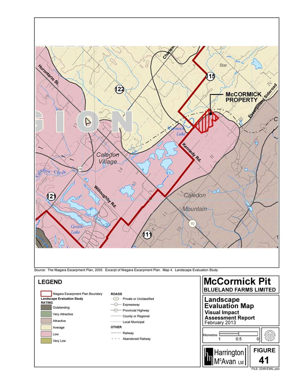
68 8.0 LANDSCAPE EVALUATION The Landscape Evaluation Study, Niagara Escarpment Planning Area (April 1976) was a Cooperative Project of the Southwestern Region and Land Use Co-ordination Branch of the Ministry of Natural Resources and the Niagara Escarpment Commission. [The] report presents a methodology which was used to evaluate the scenic quality of landscape units in the Niagara Escarpment Planning Area and outlines the basic findings of the study. The results should permit a variable grading of landscapes throughout the Niagara Escarpment Planning Area so that scenic values can be appraised along with the physical resources and constraints and cultural and economic parameters in the land use planning process. The evaluation method was designed to provide a generalized classification or ranking to represent the average viewer s appreciation of the scenic quality of each defined landscape unit. The ranking is accomplished through a scoring system based on five (5) landscape components considered to have a significant effect on viewer response: 1. Landforms 2. Vegetative cover 3. Land use 4. Special features 5. Views There are four (4) evaluated landscape units in the Niagara Escarpment Planning Area that surround and/ or overlap the subject property. See Figure 41. These landscape units are identified as: Unit Number 111 Sligo Slope Unit Number 115 Star Unit Number 121 Caledon Creek Unit Number 122 Peel Flat A summary of the Evaluation Unit Scoring Sheets for these four (4) landscape units is provided below: TABLE 16. Summary of Evaluation Unit Scoring Sheets Sligo Slope (111) Star (115) Caledon Creek (121) Peel Flat (122) Landforms Average Relative Relief 187 ft 59 ft 36.1 ft 21 ft Landform Type Hilly Hilly Rolling Flat & Gently Rolling Vegetative Cover Density % 34% 16% 8.1 % 18% Vegetative Type Mixed Conifers Pattern Open Fields & Woods Open Fields & Woods Land Use Open Fields & Woods McCormick Pit 62 Supplementary Visual Impact Assessment Report Harrington McAvan Ltd. Blueland Farms Limited February 2013
69 Description and Analysis Special Features Number of displeasing properties and buildings; few farm buildings left Small streams and ponds No outstanding non-rural farm developments; some nice rural style residences; One waste disposal site; pits and quarries Pleasing farm buildings; Some small waste disposal sites; Large pits and quarries combined with several smaller ones Some rural farm buildings Inland waterssmall lakes and stream; Considerable number of small marshy areas characteristic of open area Small lakes and small streams Inland waters not enough to impact on unit; Marshes and swamps Views Several vantage points Probably limited views outside the unit (from top of hills, etc.) Some potential to look beyond the unit, but not distinguished landscapes Good potential for viewing other units; Could be good quality views of adjacent units Total Evaluation Attractive Average Low Average Rank The subject property is bordered by the Peel Flat Landscape Unit (Unit #122) to the northwest and northeast. This unit achieved an evaluation ranking of Average. However, the subject property is located in the Caledon Creek Landscape Unit (Unit #121), which achieved an evaluation ranking of Low. The Caledon Creek Landscape Unit (Unit #121) spans an area of 18 square kilometres. The subject property covers an area of 0.25 square kilometres, equating to approximately 1.4% of the overall landscape unit area. As a result, it is anticipated that any alterations to the subject property will not have a significant impact on the evaluation ranking of the landscape unit. Progressive rehabilitation is included in the proposal for the subject property. The proposed end-use of the subject property following completion of all extraction operations includes: Open Water; Naturalized Area/ Meadow; and Reforestation. Impacts on the existing evaluation ranking for the Caledon Creek Landscape Unit (Unit #121) from the proposed end-use of the subject property were reviewed and assessed. The assessment was accomplished by completing the Evaluation Unit Scoring Sheet for the McCormick Pit 63 Supplementary Visual Impact Assessment Report Harrington McAvan Ltd. Blueland Farms Limited February 2013
70 landscape unit with the end-use of the subject property taken into consideration. The existing and the end-use evaluation rankings are summarized in Table 15. TABLE 17. Evaluation Unit Scoring Sheet: Caledon Creek (#121) Caledon Creek (#121) - EXISTING - Caledon Creek (#121) - END-USE - Landforms 0 0 Average Relative Relief 36.1 ft (+/-11.0m) 37.7 ft (+/-11.5m) Landform Type Rolling Rolling Vegetative Cover Density % 8.1 % (+/-1.46km2) 7.6% (+/-1.36km2) Vegetative Type Open Fields & Woods Open Fields & Woods Land Use 0 0 Description and Analysis Pleasing farm buildings; Some small waste disposal sites; Large pits and quarries combined with several smaller ones Pleasing farm buildings; Some small waste disposal sites; Large pits and quarries combined with several smaller ones Special Features Small lakes and small streams Small lakes and small streams Views 0 0 Some potential to look beyond the unit, but not distinguished landscapes Some potential to look beyond the unit, but not distinguished landscapes Total Evaluation Rank Low Low The landscape components that will be altered by the proposal are: Landforms and Vegetative Cover. The relative relief of the end-use of the subject property will be 151 ft (46.0m) and approximately 0.1km2 of vegetative cover will have been removed. The subject property covers 1.4% of the landscape unit area, therefore, it has been calculated that the Average Relative Relief for the Caledon Creek Landscape Unit (#121) will increase by 1.6 ft (0.5m) and the percent density of the vegetative cover will decrease by 0.5%. Although changes will be made to certain landscape components as a result of the proposed extraction and rehabilitation operations, it has been determined that the final score and evaluation rank of the Caledon Creek Landscape Unit (#121) will not be affected by the proposal for the subject property. McCormick Pit 64 Supplementary Visual Impact Assessment Report Harrington McAvan Ltd. Blueland Farms Limited February 2013
71
72 9.0 CONCLUSION As stated in the Town of Caledon Official Plan: The Town of Caledon will approve an application for an Official Plan Amendment to designate lands identified as Aggregate Resource Lands on Schedule L for a new extraction operation or expansion to an existing extraction operation when the following criteria have been met: the Applicant has completed a Visual Impact Report as described by Section and demonstrated that the proposal will not have any unacceptable impacts; In support of the application for a Category 1 Class A license, pit below water by Blueland Farms Limited, the visual impact assessment report has been completed and prepared by Harrington McAvan Ltd. (formerly Harrington and Hoyle Ltd.). It has been found that the proposal will not have any unacceptable visual impacts to its surroundings with the implementation of the recommended mitigation measures. As discussed in this report, certain visual barriers are recommended to protect and screen the visual quality of the area from the proposed operations. Due to existing views from neighbouring properties and the potential volume of pedestrian and vehicular traffic on Heart Lake Road seeded berms, minimum 3m high, shall be installed within the adjacent northwestern and northeastern regulatory setback. This installation will screen views into the subject property from Heart Lake Road are screened. The installation of native deciduous and coniferous tree species of an appropriate size to screen views shall be installed where existing vegetated visual barriers will be removed as a result of the proposed operations. The potential visual impacts can be minimized with the implementation of the mitigation measures included within this visual impact assessment report. After the final rehabilitation is completed the only change that may be noticed in the area is a pond within the McCormick Property. Refer to the Rehabilitation Plan in Figure 38. Therefore, the views into the proposed property will not be affected greatly or unacceptably during or after the proposed operations are completed. It has also been determined that the final score and evaluation rank of the Caledon Creek Landscape Unit (#121) will not be greatly affected by the proposal for the subject property. HARRINGTON McAVAN LTD. Glenn D. Harrington, OALA, FCSLA Principal McCormick Pit 66 Supplementary Visual Impact Assessment Report Harrington McAvan Ltd. Blueland Farms Limited February 2013
73 10.0 REFERENCES Harrington McAvan Ltd. (2013). Site Plans, McCormick Pit, Part of Lot 12, Concession2 EHS, Town of Caledon, Peel Region, scale 1:2000, Project No Town of Caledon. (December 31, 2008 Consolidation). Town of Caledon Official Plan. Ministry of Natural Resources & Niagara Escarpment Commission. (April 1976). Landscape Evaluation Study Niagara Escarpment Planning Area. Niagara Escarpment Commission. Landscape Evaluation Files Instructions for Use and Section Divisions Map. Niagara Escarpment Commission. (July 17, 2008). Niagara Escarpment Commission Visual Assessment Guidelines. Niagara Escarpment Commission. (February 5, 2013, Consolidation). The Niagara Escarpment Plan. McCormick Pit 67 Supplementary Visual Impact Assessment Report Harrington McAvan Ltd. Blueland Farms Limited February 2013
74 APPENDIX I
75 VISUAL IMPACTS PHASE A During Phase A Areas 1 and 2 will be affected. The Haul Route will be running through Area 2 and 1. The Plant Site is located in Area 1 and extraction will begin in Area 1. A number of views already discussed are affected by this phase of the Operations Plan. See Figure 14. View #1: View Northwest at Residence R5 One traveling northwest towards the entrance of Residence R5 and Residence R6 would view the subject property through the deciduous tree barrier. The Haul Route in Area 2 would not be a dominant impact on this view, but it may still be seen in the far Background. A visual barrier is needed. View #2: Hay Field #2 The proposed operations of this phase do not occur within this view s field of vision. A visual barrier is not needed. View #3: Hay Field #1 At the north end of the subject property is a flat existing hay field. The vegetation surrounding the open space screen the view further into the proposed extraction area and also focuses one s attention towards the vast hay field. The Haul Route is located in Area 2, which sits in the Middleground of this view. There is currently a lack of a visual barrier into this picture plane. The proposed plant site is in Area 1 and sits in the Background of this view. Visual barrier is needed. View #4: View South This view of the proposed extraction area is from the northern corner of the subject lands on Heart Lake Road. The Haul Route is located in Area 2, which sits in this view s Foreground, the most dominant picture plane. There is a lack of a visual barrier for the Haul Route. The proposed plant site is located in Area 1, the first area to be extracted, which sits in the Background. A visual barrier is needed. View #5: View Southeast One travelling southeast on Heart Lake Road towards the McCormick Property would view Hay Field #1 on the subject property through the existing sparse vegetated screen at the property boundary. The Haul Route is located in Area 2, which sits in the Background of this view. Visual barriers are needed.
76 View #6: View East From this location there is a view east towards the subject property. There is no form of a visual barrier restricting the view to only Kennedy Road. The Deciduous Woodlot located just outside of the western corner of the subject property is visible along the skyline in the Background. Although it is located in the Background, Area 1 may be seen from this viewpoint. A visual barrier may be needed. View #7: View Northeast The existing license operated by Caledon Sand and Gravel Inc. (now James Dick Construction) neighbours the subject property to the southwest. Mitigation measures have already been implemented to reduce the visual impacts of this extraction site. As a result, the subject property cannot currently be viewed from this location. A visual barrier may be needed for when extraction of the existing license is completed and the existing visual barriers are removed.
77 PHASE B During Phase B Areas 1 and 2 are affected. The Haul Route will be running through Area 2 where above water extraction will begin. The Plant Site is located in Area 1. Below water extraction and progressive rehabilitation are to take place in Area 1. A number of views already discussed are affected by this phase of the Operations Plan. See Figure 15. View #1: View Northwest at Residence R5 One traveling northwest towards the entrance of Residence R5 and Residence R6 would view the subject property through the deciduous tree barrier. The Haul Route and extraction of Area 2 would not be a dominant impact on this view, but it may still be seen in the far Background. A visual barrier is needed. View #2: Hay Field #2 Southeast of the house and sheds of Residence R4 is a hay field composed of rolling hills. This area is surrounded by Scrub Vegetation to the southwest, Residence R5 to the southeast and a post and wire fence and Heart Lake Road to the northeast. The extraction that is to take place in Area 2 does not sit within a picture plane, but can be seen through peripheral vision. Although not as significant of an impact as with other views, screening may be considered. View #3: Hay Field #1 At the north end of the subject property is a flat existing hay field. The vegetation surrounding the open space screen the view further into the subject property and also focuses one s attention towards the vast hay field. The Haul Route is located in the Middleground in Area 2 where excavation is to begin. There is currently a lack of a visual barrier into this picture plane. In the Background, with the proposed plant site, extraction and rehabilitation are to take place in Area 1. Visual barriers are needed. View #4: View South This view of the subject property is from the northern corner of the subject lands on Heart Lake Road. There is a lack of a visual barrier for Area 2 in the Foreground, where the Haul Route is located and extraction is to begin. Within Area 1, in the Background, is the Plant Site and extraction and rehabilitation are to take place. A visual barrier is needed. View #5: View Southeast One travelling southeast on Heart Lake Road towards the McCormick Property would view Hay Field #1 on the subject property through the existing sparse vegetated screen at the property boundary. The Haul Route is located in the Background in Area 2 where extraction is to begin. The proposed plant site is located in Area 1 where extraction is to continue and rehabilitation is to begin, which again sits within the Background. A visual barrier is needed.
78 View #6: View East From this location there is a view east towards the subject property. There is no form of a visual barrier restricting the view to only Kennedy Road. The Deciduous Woodlot located just outside of the western corner of the subject property is visible along the skyline in the Background. Although it is located in the Background, Area 1 may be seen from this viewpoint. A visual barrier may be needed. View #7: View Northeast The existing license operated by Caledon Sand and Gravel Inc. (now James Dick Construction) neighbours the subject property to the southwest. Mitigation measures have already been implemented to reduce the visual impacts of this extraction site. As a result, the subject property cannot currently be viewed from this location. A visual barrier may be needed for when extraction of the existing license is completed and the existing visual barriers are removed.
79 PHASE C During Phase C Areas 1, 2 and 3 are affected. The Plant Site is located in Area 1. Progressive rehabilitation is to continue in Area 1. In Area 2 below water extraction is occurring and in Area 3 above water extraction is occurring. A number of views already discussed are affected in this phase of the Operations Plan. See Figure 16. View #1: View Northwest at Residence R5 One traveling northwest towards the entrance of Residence R5 and Residence R6 would view the subject property through the deciduous tree barrier. Extraction of Area 3 sits within the Background and there is a lack of sufficient visual barrier into this view. The extraction and rehabilitation of Area 2 would not be a dominant impact on this view, but it may still be seen in the far Background. A visual barrier is needed. View #2: Hay Field #2 Southeast of the house and sheds of Residence R4 is a hay field composed of rolling hills. This area is surrounded by Scrub Vegetation to the southwest, Residence R5 to the southeast and a post and wire fence and Heart Lake Road to the northeast. Operations occurring within Area 2 may be seen through peripheral vision. Although this is not as significant of an impact as with other views screening may be considered. Extraction takes place in the Middleground in Area 3 and a visual barrier is needed. View #3: Hay Field #1 At the north end of the subject property is a flat existing hay field. The vegetation surrounding the open space screen the view further into the subject property and also focuses one s attention towards the vast field. The Haul Route is located in the Middleground in Area 2 where extraction and rehabilitation are to take place. There is currently a lack of a visual barrier into this picture plane. Along with the Plant Site, rehabilitation will take place in the Background in Area 1. Extraction in Area 3 is to take place in the Background. Visual barriers are needed. View #4: View South This view of the subject property is from the northern corner of the subject lands on Heart Lake Road. The Haul Route is located in the Foreground in Area 2 where extraction is to continue and rehabilitation is to begin. Visual screening is needed. The proposed plant site is located in Area 1 in the Background where extraction is to continue and rehabilitation is to commence. Extraction operations will take place in the Middleground in Area 3. Visual barriers are needed. View #5: View Southeast One travelling southeast on Heart Lake Road towards the McCormick Property would view Hay Field #1 on the subject property through the existing sparse vegetated screen at the property boundary. The Haul Route is located in the Background in Area 2 where extraction and rehabilitation are to take place. The existing visual barrier is in need of reinforcement. The proposed plant site is located in the Background in Area 1. Extraction and rehabilitation are to continue in Area 1. A visual barrier is needed. Finally, extraction in Area 3 can be seen in the Background from this view, therefore, screening is required.
80 View #6: View East From this location there is a view east towards the subject property. There is no form of a visual barrier restricting the view to only Kennedy Road. The Deciduous Woodlot located just outside of the western corner of the subject property is visible along the skyline in the Background. Although it is located in the Background, Area 1 may be seen from this viewpoint. A visual barrier may be needed. View #7: View Northeast The existing license operated by Caledon Sand and Gravel Inc. (now James Dick Construction) neighbours the subject property to the southwest. Mitigation measures have already been implemented to reduce the visual impacts of this extraction site. As a result, the subject property cannot currently be viewed from this location. A visual barrier may be needed for when extraction of the existing license is completed and the existing visual barriers are removed.
81 PHASE D During Phase D Areas 1, 2, 3 and 4 are affected. The Plant Site is located in Area 1. Rehabilitation is to continue in Area 1. Extraction is to be completed and rehabilitation is to continue in Area 2, rehabilitation and extraction will take place in Area 3, and extraction will begin in Area 4. A number of views already discussed are affected by this phase of the Operations Plan. See Figure 17. View #1: View Northwest at Residence R5 One traveling northwest towards the entrance of Residence R5 and Residence R6 would view the subject property through the deciduous tree barrier. There is a lack of sufficient visual barriers into Area 3 in the Background where extraction and rehabilitation are to take place. The rehabilitation of Area 2 would be not a dominating impact, but may still be seen in the far Background. A visual barrier may be considered. View #2: Hay Field #2 Southeast of the house and sheds of Residence R4 is a hay field composed of rolling hills. This area is surrounded by Scrub Vegetation to the southwest, Residence R5 to the southeast and a post and wire fence and Heart Lake Road to the northeast. Rehabilitation in Area 2 does not lie within a picture plane, but may still be seen through peripheral vision. Extraction and rehabilitation are to take place in the Middleground in Area 3 and extraction is to occur in Area 4 in the Background. Visual barriers are needed. View #3: Hay Field #1 At the north end of the subject property is a flat existing hay field. The vegetation surrounding the open space screen the view further into the subject property and also focuses one s attention towards the vast field. The Haul Route is located in the Middleground in Area 2 where rehabilitation is to take place. In the Background is Area 1 where the plant site is located and rehabilitation will continue. Extraction and rehabilitation are to occur in Area 3 and extraction is to commence in Area 4. Visual barriers are needed. View #4: View South This view of the subject property is from the northern corner of the subject lands on Heart Lake Road. The Haul Route is located in the Foreground in Area 2 where rehabilitation is to continue. Extraction is to commence in the Background in Area 4 where there is a need of a visual barrier. The Plant Site is located in Area 1 in the Background. Rehabilitation will continue in Area 1. Extraction of Area 3 in the Middleground is to continue as rehabilitation commences. Visual barriers are needed.
82 View #5: View Southeast One travelling southeast on Heart Lake Road towards the McCormick Property would view Hay Field #1 on the subject property through the existing sparse vegetated screen at the property boundary. The Haul Route is located in the Background Area 2 where rehabilitation is to occur. The existing visual barrier is in need of reinforcement. The proposed plant site is located in the Background in Area 1. Rehabilitation is to continue in Area 1. Extraction and rehabilitation are to occur in Areas 3, which may be seen in the Background. Extraction is to commence in Area 4 in the Background. Visual barriers may be considered. View #6: View East From this location there is a view east towards the subject property. There is no form of a visual barrier restricting the view to only Kennedy Road. The Deciduous Woodlot located just outside of the western corner of the subject property is visible along the skyline in the Background. Although it is located in the Background, Area 1 may be seen from this viewpoint. A visual barrier may be needed. View #7: View Northeast The existing license operated by Caledon Sand and Gravel Inc. (now James Dick Construction) neighbours the subject property to the southwest. Mitigation measures have already been implemented to reduce the visual impacts of this extraction site. As a result, the subject property cannot currently be viewed from this location. A visual barrier may be needed for when extraction of the existing license is completed and the existing visual barriers are removed.
83 PHASE E During Phase E Areas 1, 2, 3 and 4 are affected. The Plant Site is located in Area 1 and the Haul Route is located in Area 2. Rehabilitation will be completed in Area 3 and extraction and rehabilitation will continue in Area 4. A number of views already discussed are affected by this phase of the Operations Plan. See Figure 18. View #1: View Northwest at Residence R5 One traveling northwest towards the entrance of Residence R5 and Residence R6 would view the subject property through the deciduous tree barrier. The rehabilitation in Area 3 lies within the Background with a lack of a sufficient visual barrier. The Haul Route in Area 2 would not be a dominant feature of the view, but it will continue to be apparent in the far Background. Visual barriers are needed. View #2: Hay Field #2 Southeast of the house and sheds of Residence R4 is a hay field composed of rolling hills. This area is surrounded by Scrub Vegetation to the southwest, Residence R5 to the southeast and a post and wire fence and Heart Lake Road to the northeast. Rehabilitation is to take place in the Middleground in Area 3. In the Background, extraction and rehabilitation are to occur in Area 4. Visual barriers are needed. View #3: Hay Field #1 At the north end of the subject property is a flat existing hay field. The vegetation surrounding the open space screen the view further into the subject property and also focuses one s attention towards the vast field. The Haul Route is located in the Middleground in Area 2. There is currently a lack of a visual barrier into this picture plane. A visual barrier is needed. The Plant Site is located in the Background in Area 1. Also in the Background rehabilitation is to occur in Area 3. Extraction and rehabilitation operations are to occur in Area 4. Visual barriers are needed. View #4: View South This view of the subject property is from the northern corner of the subject lands on Heart Lake Road. The Haul Route is located in Area 2, which sits in this view s Foreground, the dominant picture plane. In the Background in Area 1 is the proposed plant site. Rehabilitation is to take place in the Middleground in Area 3 and extraction and rehabilitation are to take place in Area 4 in the Background. Visual barriers are needed. View #5: View Southeast One travelling southeast on Heart Lake Road towards the McCormick Property would view Hay Field #1 on the subject property through the existing sparse vegetated screen at the property boundary. The Haul Route is located in the Background in Area 2. The existing visual barrier is in need of reinforcement. Areas 1, 3 and 4 sit in the Background of this view. Visual barriers are needed to screen the view of the extraction and rehabilitation operations.
84 View #6: View East The proposed operations of this phase do not occur within this view s field of vision. A visual barrier is not needed. View #7: View Northeast The existing license operated by Caledon Sand and Gravel Inc. (now James Dick Construction) neighbours the subject property to the southwest. Mitigation measures have already been implemented to reduce the visual impacts of this extraction site. As a result, the subject property cannot currently be viewed from this location. A visual barrier may be needed for when extraction of the existing license is completed and the existing visual barriers are removed.
85 PHASE F During Phase F Area 1, 2, and 4 are affected. The Plant Site is located in Area 1. The Haul Route is located in Area 2. Extraction and Rehabilitation are to be completed in Area 4. Rehabilitation of sideslopes along the perimeter of the pond is to be completed and all equipment, scraps and machinery from Area 1 are to be removed from the subject property. Rehabilitation of the Haul Route and Plant Site are to occur. A number of views already discussed are affected by this phase of the Operations Plan. See Figure 19. View #1: View Northwest at Residence R5 One traveling northwest towards the entrance of Residence R5 and Residence R6 would view the subject property through the deciduous tree barrier. The Haul Route would not be a dominant feature of the view, but will continue to be apparent in the far Background. Visual barriers are needed. View #2: Hay Field #2 Southeast of the house and sheds of Residence R4 is a hay field composed of rolling hills. This area is surrounded by Scrub Vegetation to the southwest, Residence R5 to the southeast and a post and wire fence and Heart Lake Road to the northeast. In the Background, extraction and rehabilitation are to take place in Area 4. Visual barriers are required. View #3: Hay Field #1 At the north end of the subject property is a flat existing hay field. The vegetation surrounding the open space screen the view further into the subject property and also focuses one s attention towards the vast field. The Haul Route is located in Area 2, which sits in the Middleground. There is currently a lack of a visual barrier into this picture plane. The Plant Site is in Area 1 in the Background. Extraction and Rehabilitation are to occur in Area 4 in the Background. Visual barriers are needed. View #4: View South This view of the subject property is from the northern corner of the subject lands on Heart Lake Road. The Haul Route is located in Area 2, which sits in this view s Foreground, the most dominant picture plane. There is a lack of a visual barrier for the Haul Route. The proposed plant site is located in Area 1, which sits in the Background. Area 4 lies in the Background where there is no form of a visual barrier present. Extraction and rehabilitation is to occur in Area 4. Visual barriers are needed. View #5: View Southeast One travelling southeast on Heart Lake Road towards the McCormick Property would view Hay Field #1 on the subject property through the existing sparse vegetated screen at the property boundary. The Haul Route is located in Area 2, which sits in the Background of this view. The existing visual barrier is in need of reinforcement. Area 1 sits in the Background of this view along with Area 4 where rehabilitation and extraction are to take place. Visual screening is required.
86 View #6: View East The proposed operations of this phase do not occur within this view s field of vision. A visual barrier is not needed. View #7: View Northeast The existing license operated by Caledon Sand and Gravel Inc. (now James Dick Construction) neighbours the subject property to the southwest. Mitigation measures have already been implemented to reduce the visual impacts of this extraction site. As a result, the subject property cannot currently be viewed from this location. A visual barrier may be needed for when extraction of the existing license is completed and the existing visual barriers are removed.
87 PHASE G During Phase G Area 1 and 2 are affected. Below water extraction and rehabilitation are to be completed in Area 1 and 2. Rehabilitation of the side slopes along the perimeter of the pond is to be completed. Upon completion of extraction all equipment, structures, scraps and machinery will be removed from the site and all haul roads and the plant site will be rehabilitated. A number of views already discussed are affected by this phase of operations. View #1: View Northwest at Residence R5 One traveling northwest towards the entrance of Residence R5 and Residence R6 would view the subject property through the deciduous tree barrier. The Haul Route in Area 2 would not be a dominant feature of the view, but will continue to be apparent in the far Background. Extraction and rehabilitation are to occur in Area 2. Visual barriers are needed. View #2: Hay Field #2 The proposed operations of this phase do not occur within this view s field of vision. A visual barrier is not needed. View #3: Hay Field #1 At the north end of the subject property is a flat existing hay field. The vegetation surrounding the open space screen the view further into the subject property and also focuses one s attention towards the vast field. The Haul Route is located in Area 2, which sits in the Middleground. Extraction and rehabilitation operations are to occur in Area 2. There is currently a lack of a visual barrier into this picture plane. The Plant Site is in Area 1 in the Background. Extraction and Rehabilitation are to occur in Area 1 in the Background. The existing visual barrier into this area will be removed as a result of the operations in this Phase. Visual barriers are needed. View #4: View South This view of the subject property is from the northern corner of the subject lands on Heart Lake Road. The Haul Route is located in Area 2, which sits in this view s Foreground, the most dominant picture plane. Extraction and rehabilitation operations are to occur in Area 2. There is a lack of a visual barrier for this area. The proposed plant site is located in Area 1, which sits in the Background. Extraction and rehabilitation operations are to occur in this Area. The existing visual barrier into this area will be removed as a result of the operations in this Phase. Visual barriers are needed. View #5: View Southeast One travelling southeast on Heart Lake Road towards the McCormick Property would view Hay Field #1 on the subject property through the existing sparse vegetated screen at the property boundary. The Haul Route is located in Area 2, which sits in the Background of this view. Extraction and rehabilitation operations are to occur in this area. The existing visual barrier is in need of reinforcement. Area 1 sits in the Background of this view where the proposed plant site is located. Rehabilitation and extraction are to occur in Area 1. Visual screening is required.
88 View #6: View East The proposed operations of this phase do not occur within this view s field of vision. A visual barrier is not needed. View #7: View Northeast The existing license operated by Caledon Sand and Gravel Inc. (now James Dick Construction) neighbours the subject property to the southwest. Mitigation measures have already been implemented to reduce the visual impacts of this extraction site. As a result, the subject property cannot currently be viewed from this location. A visual barrier may be needed for when extraction of the existing license is completed and the existing visual barriers are removed.
89 APPENDIX II
90 MITIGATION MEASURES PHASE A During Phase A Areas 1 and 2 will be affected. The Haul Route will be running through Area 2 and 1. The Plant Site is located in Area 1 and extraction will begin in Area 1. A number of visual impacts have been discussed. These impacts may be minimized with the recommended mitigation measures. See Figure 20. View #1: View Northwest at Residence R5 Haul Route: The Haul Route would not have a dominant impact on this existing view, but it may be seen in the far Background through the sparse deciduous tree screen along the northwest property line of Residence R5. A temporary seeded berm minimum 3m high shall be installed within the regulatory setback adjacent to the northwestern property line of Residence R5. Mitigation is recommended. View #3: Hay Field #1 Haul Route: The Haul Route is not hidden within the Middleground of this view. There is no existing visual barrier to screen the view of the Haul Route in Hay Field #1 from Heart Lake Road. With the potential volume of pedestrian and vehicular traffic on Heart Lake Road a temporary seeded berm minimum 3m high shall be installed within the northeastern regulatory setback adjacent to Area 2 prior to the establishment of the Haul Route. Mitigation is recommended. Proposed Plant Site: This Plant Site lies within Area 1 in the Background causing it to be faintly visible behind Area 2. Area 2 lies within Hay Field #1, where there is no existing visual barrier to screen the view of the Proposed Plant Site from Heart Lake Road. At a minimum, a temporary seeded berm minimum 3m high shall be installed within the northeastern regulatory setback adjacent to Area 2 prior to the establishment of the Proposed Plant Site. Mitigation is recommended. Extraction Area: Extraction is to occur in Area 1, which is in the Background of this view behind Area 2. Area 2 lies within Hay Field #1, where there is no existing visual barrier to screen the view of the Extraction Area from Heart Lake Road. At a minimum, a temporary seeded berm minimum 3m high shall be installed within the northeastern regulatory setback adjacent to Area 2 prior to the extraction operations in Area 1. Mitigation is recommended. View #4: View South Haul Route: The Haul Route is situated within the Foreground, which causes it to be a dominant feature. Therefore, a visual barrier is recommended. Currently there is the presence of deciduous trees sparsely placed between the northwestern edge of the subject property and the property line of Residence R1. Due to the dominance in the picture plane a temporary seeded berm minimum 3m high shall be installed within the northwestern regulatory setback adjacent to Area 2 prior to the establishment of the Haul Route. Mitigation is recommended. Proposed Plant Site: This plant site lies within Area 1 in the Background causing it to be faintly visible behind Area 2. Area 2 lies within Hay Field #1, where there is no existing visual barrier to screen the view of the Proposed Plant Site from Heart Lake Road. At a minimum, a
91 temporary seeded berm minimum 3m high shall be installed within the northwestern regulatory setback adjacent to Area 2 prior to the establishment of the Proposed Plant Site. Mitigation is recommended. Extraction Area: Extraction is to occur in Area 1, which is in the Background of this view behind Area 2. Area 2 lies within Hay Field #1, where there is no existing visual barrier to screen the view of this Extraction Area from Heart Lake Road. At a minimum, a temporary seeded berm minimum 3m high shall be installed within the northwestern regulatory setback adjacent to Area 2 prior to the extraction operations in Area 1. Mitigation is recommended. View #5: View Southeast Haul Route: The Haul Route is located in the Background of this view. Due to the visual impact on the view a visual barrier is recommended. Currently there is the presence of deciduous trees sparsely placed between the northwestern edge of the subject property and the property line of Residence R1. A temporary seeded berm minimum 3m high installed within the northwestern regulatory setback adjacent to Area 2 prior to the establishment of the Haul Route. Mitigation is recommended. Proposed Plant Site: This proposed Plant Site lies within Area 1 in the Background of this view. Currently a sparsely spaced deciduous tree screen and the Deciduous Woodlot surrounding Warnock Lake restrict most of the view into Area 1. A temporary seeded berm minimum 3m high installed within the northwestern regulatory setback adjacent to Area 2 prior to the establishment of the Proposed Plant Site. Mitigation is recommended. Extraction Area: Extraction is to take place in Area 1 in the Background of this view. Currently a sparsely spaced deciduous tree screen and the Deciduous Woodlot surrounding Warnock Lake restrict most of the view into Area 1. A temporary seeded berm minimum 3m high installed within the northwestern regulatory setback adjacent to Area 2 prior to the extraction operations in Area 1. Mitigation is recommended. View #6: View East Extraction Area: Extraction is to occur in Area 1, which is in the Background of this view. Area 1 is already located in the Deciduous Woodlot and Scrub Vegetation, which will be removed as a result of the extraction operations. Native deciduous and coniferous tree species shall be installed within the southwestern regulatory setback prior to the extraction operations in Area 1 commencing to screen the view into Area 1. Mitigation is recommended. View #7: View Northeast Extraction Area: Extraction is to occur in Area 1, which is in the Background of this view. Area 1 is already located in the Deciduous Woodlot and Scrub Vegetation, which will be removed as a result of the extraction operations. Native deciduous and coniferous tree species shall be installed within the southwestern regulatory setback prior to the extraction operations in Area 1 commencing to screen the view into Area 1. Mitigation is recommended.
92 PHASE B During Phase B Areas 1 and 2 are affected. The Haul Route will be running through Area 2 where above water extraction will begin. The Plant Site is located in Area 1. Below water extraction and progressive rehabilitation are to take place in Area 1. A number of visual impacts have been discussed. These impacts may be minimized with the recommended mitigation measures. See Figure 21. View #1: View Northwest at Residence R5 Haul Route: The Haul Route would not have a dominant impact on this existing view, but it may be seen in the far Background through the sparse deciduous tree screen along the northwest property line of Residence R5. A temporary seeded berm minimum 3m high shall be installed within the regulatory setback adjacent to the northwestern property line of Residence R5 prior to the establishment of the Haul Route. Mitigation is recommended. Extraction Area: Extraction is to take place in Area 2 which sits in the far Background of this view. There are currently deciduous trees sparsely placed between the subject property and the northwestern property line of Residence R5. A temporary seeded berm minimum 3m high shall be installed within the regulatory setback adjacent to the northwestern property line of Residence R5 prior to the extraction operations in Area 2. Mitigation is recommended. View #2: Hay Field #2 Extraction Area: Extraction is to occur in Area 2, which can be seen through peripheral vision. Therefore, a visual barrier is recommended. A temporary seeded berm minimum 3m high shall be installed within the northeastern regulatory setback adjacent to Area 2 prior to the extraction operations in Area 2 commencing. Mitigation is recommended. View #3: Hay Field #1 Haul Route: The Haul Route is not hidden within the Middleground of this view. There is no existing visual barrier to screen the view of the Haul Route in Hay Field #1 from Heart Lake Road. With the potential volume of pedestrian and vehicular traffic on Heart Lake Road a temporary seeded berm minimum 3m high shall be installed within the northeastern regulatory setback adjacent to Area 2 prior to the establishment of the Haul Route. Mitigation is recommended. Extraction Area: Extraction is to occur in Area 2, which is in the Middleground of this view. Therefore, a visual barrier is recommended. Currently there is no visual barrier to screen the view of the Extraction Area in Hay Field #1 from Heart Lake Road. With the potential volume of pedestrian and vehicular traffic on Heart Lake Road a temporary seeded berm minimum 3m high shall be installed within the northeastern regulatory setback adjacent to Area 2 prior to the extraction operations in Area 2. Mitigation is recommended. Proposed Plant Site: This Plant Site lies within Area 1 in the Background causing it to be faintly visible behind Area 2. Area 2 lies within Hay Field #1, where there is no existing visual barrier to screen the view of the Proposed Plant Site from Heart Lake Road. With the potential volume of pedestrian and vehicular traffic on Heart Lake Road a temporary seeded berm minimum 3m high shall be installed within the northeastern regulatory setback adjacent to Area 2 prior to the establishment of the Proposed Plant Site. Mitigation is recommended. Rehabilitation and Extraction Area: Rehabilitation and extraction are to occur in Area 1, which is in the Background of this view behind Area 2. Area 2 lies within Hay Field #1, where there is no
93 existing visual barrier to screen the view of the Extraction Area from Heart Lake Road. With the potential volume of pedestrian and vehicular traffic on Heart Lake Road a temporary seeded berm minimum 3m high shall be installed within the northeastern regulatory setback adjacent to Area 2 prior to operations in Area 1. Mitigation is recommended. View #4: View South Haul Route: The Haul Route is situated within the Foreground, which causes it to be a dominant feature. Therefore, a visual barrier is recommended. Currently there is the presence of deciduous trees sparsely placed between the northwestern edge of the subject property and the property line of Residence R1. Due to the dominance in the picture plane a temporary seeded berm minimum 3m high shall be installed within the northwestern regulatory setback adjacent to Area 2 prior to the establishment of the Haul Route. Mitigation is recommended. Extraction Area: Extraction is to occur in Area 2, which is a dominant feature in the Foreground of this view. Therefore, a visual barrier is recommended. Area 2 lies within Hay Field #1, where there is no existing visual barrier to screen the view of the Extraction Area from Heart Lake Road. Due to the dominance in the picture plane a temporary seeded berm minimum 3m high shall be installed within the northwestern regulatory setback adjacent to Area 2 prior to the extraction operations in Area 2. Mitigation is recommended. Proposed Plant Site: This plant site lies within Area 1 in the Background causing it to be faintly visible behind Area 2. Area 2 lies within Hay Field #1, where there is no existing visual barrier to screen the view of the Proposed Plant Site from Heart Lake Road. A temporary seeded berm minimum 3m high shall be installed within the northwestern regulatory setback adjacent to Area 2 prior to the establishment of the Proposed Plant Site. Mitigation is recommended. Rehabilitation and Extraction Area: Rehabilitation and extraction are to occur in Area 1, which is in the Background of this view behind Area 2. Area 2 lies within Hay Field #1, where there is no existing visual barrier to screen the view of this Extraction Area from Heart Lake Road. A temporary seeded berm minimum 3m high shall be installed within the northwestern regulatory setback adjacent to Area 2 prior to the operations in Area 1 commencing. Mitigation is recommended. View #5: View Southeast Haul Route: The Haul Route is located in the Background of this view. Due to the visual impact on the view a visual barrier is recommended. Currently there is the presence of deciduous trees sparsely placed between the northwestern edge of the subject property and the property line of Residence R1. A seeded berm minimum 3m high shall be installed within the northwestern regulatory setback adjacent to Area 2 prior to the establishment of the Haul Route. Mitigation is recommended. Extraction Area: The extraction is to take place in Area 2 which is located in the Background. Although it is faintly visible, a visual barrier is still recommended. Currently there is the presence of deciduous trees sparsely placed between the northwestern edge of the subject property and the property line of Residence R1. A seeded berm minimum 3m high shall be installed within the northwestern regulatory setback adjacent to Area 2 prior to extraction operations commencing in Area 2. Mitigation is recommended. Proposed Plant Site: This proposed Plant Site lies within Area 1 in the Background of this view. Currently a sparsely spaced deciduous tree screen and the Deciduous Woodlot surrounding Warnock Lake restrict most of the view into Area 1. A seeded berm minimum 3m high shall be
94 installed within the northwestern regulatory setback adjacent to Area 2 prior to the establishment of the Proposed Plant Site. Mitigation is recommended. Rehabilitation and Extraction Area: Rehabilitation and extraction are to take place in Area 1 in the Background of this view. Currently a sparsely spaced deciduous tree screen and the Deciduous Woodlot surrounding Warnock Lake restrict most of the view into Area 1. A seeded berm minimum 3m high shall be installed within the northwestern regulatory setback adjacent to Area 2 prior to operations commencing in Area 1. Mitigation is recommended. View #6: View East Rehabilitation and Extraction Area: Rehabilitation and extraction are to occur in Area 1, which is in the Background of this view. Area 1 is already located in the Deciduous Woodlot and Scrub Vegetation, which will be removed as a result of the extraction operations. Native deciduous and coniferous tree species shall be installed within the southwestern regulatory setback prior to the extraction operations in Area 1. Mitigation is recommended. View #7: View Northeast Rehabilitation and Extraction Area: Rehabilitation and extraction are to occur in Area 1, which is in the Background of this view. Area 1 is already located in the Deciduous Woodlot and Scrub Vegetation, which will be removed as a result of the extraction operations. Native deciduous and coniferous tree species shall be installed within the southwestern regulatory setback prior to the extraction operations in Area 1 commencing to screen the view into Area 1. Mitigation is recommended.
95 PHASE C During Phase C Areas 1, 2 and 3 are affected. The Plant Site is located in Area 1. Progressive rehabilitation is to continue in Area 1. In Area 2 below water extraction is occurring and in Area 3 above water extraction is occurring. A number of visual impacts have been discussed. These impacts may be minimized with the recommended mitigation measures. See Figure 22. View #1: View Northwest at Residence R5 Extraction Area: Extraction is to take place in Area 3, which is in the Background of this view. There are currently deciduous trees sparsely placed between the subject property and the northwestern property line of Residence R5. A temporary seeded berm minimum 3m high shall be installed within the regulatory setback adjacent to the northwestern property line of Residence R5 prior to extraction operations commencing in Area 3. Mitigation is recommended. Haul Route: The Haul Route would not have a dominant impact on this existing view, but it may be seen in the far Background through the sparse deciduous tree screen along the northwest property line of Residence R5. A temporary seeded berm minimum 3m high shall be installed within the regulatory setback adjacent to the northwestern property line of Residence R5 prior to the establishment of the Haul Route. Mitigation is recommended. Rehabilitation and Extraction Area: Rehabilitation and extraction operations are to take place in Area 2 which sits in the far Background of this view. There are currently deciduous trees sparsely placed between the subject property and the northwestern property line of Residence R5. A temporary seeded berm minimum 3m high shall be installed within the regulatory setback adjacent to the northwestern property line of Residence R5 prior to operations commencing in Area 2. Mitigation is recommended. View #2: Hay Field #2 Extraction Area: Extraction is to take place in Area 3, which is located within the Middleground. Currently there is no visual barrier screening the view of the Extraction Area from Heart Lake Road. With the potential volume of pedestrian and vehicular traffic on Heart Lake Road a temporary seeded berm minimum 3m high shall be installed within the northeastern regulatory setback adjacent to Area 3 prior to extraction operations commencing in Area 3. Mitigation is recommended. Rehabilitation and Extraction Area: Rehabilitation and extraction is to occur in Area 2, which can be seen through peripheral vision. Therefore, a visual barrier is recommended. A temporary seeded berm minimum 3m high shall be installed within the northeastern regulatory setback adjacent to Area 2 prior to the operations in Area 2 commencing. Mitigation is recommended. View #3: Hay Field #1 Haul Route: The Haul Route is not hidden within the Middleground of this view. There is no existing visual barrier to screen the view of the Haul Route in Hay Field #1 from Heart Lake Road. With the potential volume of pedestrian and vehicular traffic on Heart Lake Road a temporary seeded berm minimum 3m high shall be installed within the northeastern regulatory setback adjacent to Area 2 prior to the establishment of the Haul Route. Mitigation is recommended. Rehabilitation and Extraction Area: Rehabilitation and extraction operations are to occur in Area 2, which is in the Middleground of this view. Therefore, a visual barrier is recommended.
96 Currently there is no visual barrier to screen the view of the Extraction Area in Hay Field #1 from Heart Lake Road. With the potential volume of pedestrian and vehicular traffic on Heart Lake Road a temporary seeded berm minimum 3m high shall be installed within the northeastern regulatory setback adjacent to Area 2 prior to operations commencing in Area 2. Mitigation is recommended. Proposed Plant Site: This Plant Site lies within Area 1 in the Background causing it to be faintly visible behind Area 2. Area 2 lies within Hay Field #1, where there is no existing visual barrier to screen the view of the Proposed Plant Site from Heart Lake Road. With the potential volume of pedestrian and vehicular traffic on Heart Lake Road a temporary seeded berm minimum 3m high shall be installed within the northeastern regulatory setback adjacent to Area 2 prior to the establishment of the Proposed Plant Site. Mitigation is recommended. Rehabilitation and Extraction Area: Rehabilitation and extraction are to occur in Area 1, which is in the Background of this view behind Area 2. Area 2 lies within Hay Field #1, where there is no existing visual barrier to screen the view of the Extraction Area from Heart Lake Road. With the potential volume of pedestrian and vehicular traffic on Heart Lake Road a temporary seeded berm minimum 3m high shall be installed within the northeastern regulatory setback adjacent to Area 2 prior to the operations commencing in Area 1. Mitigation is recommended. Extraction Area: Extraction is to take place in Area 3, which is located within the Background. Currently there is no visual barrier. A temporary seeded berm minimum 3m high shall be installed within the northeastern regulatory setback adjacent to Area 2 prior to the extraction operations commencing in Area 3. Mitigation is recommended. View #4: View South Haul Route: The Haul Route is situated within the Foreground, which causes it to be a dominant feature. Therefore, a visual barrier is recommended. Currently there is the presence of deciduous trees sparsely placed between the northwestern edge of the subject property and the property line of Residence R1. With the potential volume of pedestrian and vehicular traffic on Heart Lake Road a temporary seeded berm minimum 3m high shall be installed within the northwestern regulatory setback adjacent to Area 2 prior to the establishment of the Haul Route. Mitigation is recommended. Rehabilitation and Extraction Area: Rehabilitation and extraction are to occur in Area 2, which is a dominant feature in the Foreground of this view. Therefore, a visual barrier is recommended. Area 2 lies within Hay Field #1, where there is no existing visual barrier to screen the view of the Extraction Area from Heart Lake Road. With the potential volume of pedestrian and vehicular traffic on Heart Lake Road a temporary seeded berm minimum 3m high shall be installed within the northwestern regulatory setback adjacent to Area 2 prior to the operations commencing in Area 2. Mitigation is recommended. Proposed Plant Site: This plant site lies within Area 1 in the Background causing it to be faintly visible behind Area 2. Area 2 lies within Hay Field #1, where there is no existing visual barrier to screen the view of the Proposed Plant Site from Heart Lake Road. With the potential volume of pedestrian and vehicular traffic on Heart Lake Road a temporary seeded berm minimum 3m high shall be installed within the northwestern regulatory setback adjacent to Area 2 prior to the establishment of the Proposed Plant Site. Mitigation is recommended. Rehabilitation and Extraction Area: Rehabilitation and extraction operations are to continue in Area 1, which is in the Background of this view behind Area 2. Area 2 lies within Hay Field #1,
97 where there is no existing visual barrier to screen the view of this Extraction Area from Heart Lake Road. With the potential volume of pedestrian and vehicular traffic on Heart Lake Road a temporary seeded berm minimum 3m high shall be installed within the northwestern regulatory setback adjacent to Area 2 prior to the operations commencing in Area 1. Mitigation is recommended. Extraction Area: Extraction is to take place in Area 3, which is in the Middleground of this view. A temporary seeded berm minimum 3m high shall be installed within the northwestern and northeastern regulatory setback adjacent to Area 3 prior to the extraction operations in Area 3 commencing. Mitigation is recommended. View #5: View Southeast Haul Route: The Haul Route is located in the Background of this view. Due to the visual impact on the view a visual barrier is recommended. Currently there is the presence of deciduous trees sparsely placed between the northwestern edge of the subject property and the property line of Residence R1. A temporary seeded berm minimum 3m high shall be installed within the northwestern regulatory setback adjacent to Area 2 prior to the establishment of the Haul Route. Mitigation is recommended. Rehabilitation and Extraction Area: Rehabilitation and extraction operations are to take place in Area 2 which is located in the Background. Although it is faintly visible, a visual barrier is still recommended. Currently there is the presence of deciduous trees sparsely placed between the northwestern edge of the subject property and the property line of Residence R1. A temporary seeded berm minimum 3m high shall be installed within the northwestern regulatory setback adjacent to Area 2 prior to operations in this area commencing. Mitigation is recommended. Proposed Plant Site: This proposed Plant Site lies within Area 1 in the Background of this view. Currently a sparsely spaced deciduous tree screen and the Deciduous Woodlot surrounding Warnock Lake restrict most of the view into Area 1. A temporary seeded berm minimum 3m high shall be installed within the northwestern regulatory setback adjacent to Area 2 prior to the establishment of the Proposed Plant Site. Mitigation is recommended Rehabilitation and Extraction Area: Rehabilitation and extraction are to take place in Area 1 in the Background of this view. Currently a sparsely spaced deciduous tree screen and the Deciduous Woodlot surrounding Warnock Lake restrict most of the view into Area 1. A temporary seeded berm minimum 3m high shall be installed within the northwestern regulatory setback adjacent to Area 2 prior to operations in this area commencing. Mitigation is recommended Extraction Area: Extraction is to take place in Area 3, which is located in the Background of this view. Although it is faintly visible, a visual barrier is still recommended. Currently there is the presence of deciduous trees sparsely placed between the northwestern edge of the subject property and the property line of Residence R1. A temporary seeded berm minimum 3m high shall be installed within the northwestern regulatory setback adjacent to Area 2 prior to operations in this area commencing. Mitigation is recommended
98 View #6: View East Rehabilitation and Extraction Area: Rehabilitation and extraction are to occur in Area 1, which is in the Background of this view. Area 1 is already located in the Deciduous Woodlot and Scrub Vegetation, which will be removed as a result of the extraction operations. Native deciduous and coniferous tree species shall be installed within the southwestern regulatory setback prior to the extraction operations in Area 1 commencing to screen the view into Area 1. Mitigation is recommended. View #7: View Northeast Rehabilitation and Extraction Area: Rehabilitation and extraction are to occur in Area 1, which is in the Background of this view. Area 1 is already located in the Deciduous Woodlot and Scrub Vegetation, which will be removed as a result of the extraction operations. Native deciduous and coniferous tree species shall be installed within the southwestern regulatory setback prior to the extraction operations in Area 1 commencing to screen the view into Area 1. Mitigation is recommended.
99 PHASE D During Phase D Areas 1, 2, 3 and 4 are affected. The Plant Site is located in Area 1 where rehabilitation is to continue. Extraction is to be completed and rehabilitation is to continue in Area 2, rehabilitation and extraction will take place in Area 3, and extraction will begin in Area 4. A number of visual impacts have been discussed. These impacts may be minimized with the recommended mitigation measures. See Figure 23. View #1: View Northwest at Residence R5 Rehabilitation and Extraction Area: Rehabilitation and extraction operations are to take place in Area 3, which is in the Background of this view. There are currently deciduous trees sparsely placed between the subject property and the northwestern property line of Residence R5. A temporary seeded berm minimum 3m high shall be installed within the regulatory setback adjacent to the northwestern property line of Residence R5 prior to operations commencing in Area 3. Mitigation is recommended. Haul Route: The Haul Route would not have a dominant impact on this existing view, but it may be seen in the far Background through the sparse deciduous tree screen along the northwest property line of Residence R5. A temporary seeded berm minimum 3m high shall be installed within the regulatory setback adjacent to the northwestern property line of Residence R5 prior to the establishment of the Haul Route. Mitigation is recommended. Rehabilitation Area: Rehabilitation operations are to take place in Area 2 which sits in the far Background of this view. There are currently deciduous trees sparsely placed between the subject property and the northwestern property line of Residence R5. A temporary seeded berm minimum 3m high shall be installed within the regulatory setback adjacent to the northwestern property line of Residence R5 prior to operations commencing in Area 2. Mitigation is recommended. View #2: Hay Field #2 Rehabilitation and Extraction Area: Rehabilitation and extraction operations are to take place in Area 3, which is located within the Middleground. Currently there is no visual barrier screening the view of the Extraction Area from Heart Lake Road. With the potential volume of pedestrian and vehicular traffic on Heart Lake Road a temporary seeded berm minimum 3m high shall be installed within the northeastern regulatory setback adjacent to Area 3 prior to operations commencing in Area 3. Mitigation is recommended. Extraction Area: Extraction is to take place in Area 4 in the Background of this view. Currently there are no visual barriers to screen the view of the Extraction Area from Heart Lake Road. A temporary seeded berm minimum 3m high shall be installed within the northeastern regulatory setback adjacent to Area 4 prior to operations commencing in Area 4. Mitigation is recommended. Rehabilitation Area: Rehabilitation will be continuing in Area 2, which can be seen through peripheral vision. Therefore, a visual barrier is recommended. A temporary seeded berm minimum 3m high shall be installed within the northeastern regulatory setback adjacent to Area 2 prior to the operations in Area 2 commencing. Mitigation is recommended. View #3: Hay Field #1 Haul Route: The Haul Route is not hidden within the Middleground of this view. There is no existing visual barrier to screen the view of the Haul Route in Hay Field #1 from Heart Lake
100 Road. With the potential volume of pedestrian and vehicular traffic on Heart Lake Road a temporary seeded berm minimum 3m high shall be installed within the northeastern regulatory setback adjacent to Area 2 prior to the establishment of the Haul Route. Mitigation is recommended. Rehabilitation Area: Rehabilitation is to occur in Area 2, which is in the Middleground of this view. Therefore, a visual barrier is recommended. Currently there is no visual barrier to screen the view of the Extraction Area in Hay Field #1 from Heart Lake Road. With the potential volume of pedestrian and vehicular traffic on Heart Lake Road a temporary seeded berm minimum 3m high shall be installed within the northeastern regulatory setback adjacent to Area 2 prior to operations commencing in Area 2. Mitigation is recommended. Proposed Plant Site: This Plant Site lies within Area 1 in the Background causing it to be faintly visible behind Area 2. Area 2 lies within Hay Field #1, where there is no existing visual barrier to screen the view of the Proposed Plant Site from Heart Lake Road. With the potential volume of pedestrian and vehicular traffic on Heart Lake Road a temporary seeded berm minimum 3m high shall be installed within the northeastern regulatory setback adjacent to Area 2 prior to the establishment of the Proposed Plant Site. Mitigation is recommended. Rehabilitation Area: Rehabilitation is to occur in Area 1, which is in the Background of this view behind Area 2. Area 2 lies within Hay Field #1, where there is no existing visual barrier to screen the view of the Extraction Area from Heart Lake Road. With the potential volume of pedestrian and vehicular traffic on Heart Lake Road a temporary seeded berm minimum 3m high shall be installed within the northeastern regulatory setback adjacent to Area 2 prior to the operations commencing in Area 1. Mitigation is recommended. Rehabilitation and Extraction Area: Rehabilitation and extraction operations are to take place in Area 3, which is located within the Background. Currently there is no visual barrier. A temporary seeded berm minimum 3m high shall be installed within the northeastern regulatory setback adjacent to Area 2 prior to operations commencing in Area 3. Mitigation is recommended. Extraction Area: Extraction is to take place in Area 4 in the Background. A temporary seeded berm minimum 3m high shall be installed within the northeastern regulatory setback adjacent to Area 2 prior to the extraction operations commencing in Area 4. Mitigation is recommended. View #4: View South Haul Route: The Haul Route is situated within the Foreground, which causes it to be a dominant feature. Therefore, a visual barrier is recommended. Currently there is the presence of deciduous trees sparsely placed between the northwestern edge of the subject property and the property line of Residence R1. With the potential volume of pedestrian and vehicular traffic on Heart Lake Road a temporary seeded berm minimum 3m high shall be installed within the northwestern regulatory setback adjacent to Area 2 prior to the establishment of the Haul Route. Mitigation is recommended. Rehabilitation Area: Rehabilitation is to occur in Area 2, which is a dominant feature in the Foreground of this view. Therefore, a visual barrier is recommended. Area 2 lies within Hay Field #1, where there is no existing visual barrier to screen the view of the Extraction Area from Heart Lake Road. With the potential volume of pedestrian and vehicular traffic on Heart Lake Road a temporary seeded berm minimum 3m high shall be installed within the northwestern
101 regulatory setback adjacent to Area 2 prior to the operations commencing in Area 2. Mitigation is recommended. Extraction Area: Extraction is to take place in the Background in Area 4. A temporary seeded berm minimum 3m high shall be installed within the northwestern regulatory setback adjacent to Area 2 prior to the extraction operations commencing in Area 4. Mitigation is recommended. Proposed Plant Site: This plant site lies within Area 1 in the Background causing it to be faintly visible behind Area 2. Area 2 lies within Hay Field #1, where there is no existing visual barrier to screen the view of the Proposed Plant Site from Heart Lake Road. With the potential volume of pedestrian and vehicular traffic on Heart Lake Road a temporary seeded berm minimum 3m high shall be installed within the northwestern regulatory setback adjacent to Area 2 prior to the establishment of the Proposed Plant Site. Mitigation is recommended. Rehabilitation and Extraction Area: Rehabilitation and extraction operations are to continue in Area 1, which is in the Background of this view behind Area 2. Area 2 lies within Hay Field #1, where there is no existing visual barrier to screen the view of this Extraction Area from Heart Lake Road. With the potential volume of pedestrian and vehicular traffic on Heart Lake Road a temporary seeded berm minimum 3m high shall be installed within the northwestern regulatory setback adjacent to Area 2 prior to the operations commencing in Area 1. Mitigation is recommended. Rehabilitation and Extraction Area: Rehabilitation and extraction operations are to take place in Area 3, which is in the Middleground of this view. A temporary seeded berm minimum 3m high shall be installed within the northwestern and northeastern regulatory setback adjacent to Area 3 prior to the extraction operations in Area 3 commencing. Mitigation is recommended. View #5: View Southeast Haul Route: The Haul Route is located in the Background of this view. Due to the visual impact on the view a visual barrier is recommended. Currently there is the presence of deciduous trees sparsely placed between the northwestern edge of the subject property and the property line of Residence R1. A temporary seeded berm minimum 3m high shall be installed within the northwestern regulatory setback adjacent to Area 2 prior to the establishment of the Haul Route. Mitigation is recommended. Rehabilitation Area: Rehabilitation operations are to take place in Area 2 which is located in the Background. Although it is faintly visible, a visual barrier is still recommended. Currently there is the presence of deciduous trees sparsely placed between the northwestern edge of the subject property and the property line of Residence R1. A temporary seeded berm minimum 3m high shall be installed within the northwestern regulatory setback adjacent to Area 2 prior to operations in this area commencing. Mitigation is recommended. Proposed Plant Site: This proposed Plant Site lies within Area 1 in the Background of this view. Currently a sparsely spaced deciduous tree screen and the Deciduous Woodlot surrounding Warnock Lake restrict most of the view into Area 1. A temporary seeded berm minimum 3m high shall be installed within the northwestern regulatory setback adjacent to Area 2 prior to the establishment of the Proposed Plant Site. Mitigation is recommended Rehabilitation and Extraction Area: Rehabilitation and extraction are to take place in Area 1 in the Background of this view. Currently a sparsely spaced deciduous tree screen and the Deciduous Woodlot surrounding Warnock Lake restrict most of the view into Area 1. A
102 temporary seeded berm minimum 3m high shall be installed within the northwestern regulatory setback adjacent to Area 2 prior to operations in this area commencing. Mitigation is recommended Rehabilitation and Extraction Area: Rehabilitation and extraction operations are to take place in Area 3, which is located in the Background of this view. Although it is faintly visible, a visual barrier is still recommended. Currently there is the presence of deciduous trees sparsely placed between the northwestern edge of the subject property and the property line of Residence R1. A temporary seeded berm minimum 3m high shall be installed within the northwestern regulatory setback adjacent to Area 2 prior to operations in this area commencing. Mitigation is recommended Extraction Area: Extraction is to take place in Area 4 which is in the Background of this view. Currently there is the presence of deciduous trees sparsely placed between the northwestern edge of the subject property and the property line of Residence R1. A temporary seeded berm minimum 3m high shall be installed within the northwestern regulatory setback adjacent to Area 2 prior to extraction operations in Area 4 commencing. Mitigation is recommended View #6: View East Rehabilitation Area: Rehabilitation and extraction are to occur in Area 1, which is in the Background of this view. Area 1 is already located in the Deciduous Woodlot and Scrub Vegetation, which will be removed as a result of the extraction operations. Native deciduous and coniferous tree species shall be installed within the southwestern regulatory setback prior to the extraction operations in Area 1 commencing to screen the view into Area 1. Mitigation is recommended. View #7: View Northeast Rehabilitation Area: Rehabilitation is to occur in Area 1, which is in the Background of this view. Area 1 is already located in the Deciduous Woodlot and Scrub Vegetation, which will be removed as a result of the extraction operations. Native deciduous and coniferous tree species shall be installed within the southwestern regulatory setback prior to any operations in Area 1 commencing to screen the view into Area 1. Mitigation is recommended. Extraction Area: Extraction is to take place in Area 4, which sits in the Background of this view. Area 4 is already located in the Deciduous Woodlot, which will partially be removed as a result of the extraction operations. Native deciduous and coniferous tree species shall be installed within the southwestern regulatory setback prior to any operations in Area 4 commencing to screen the view into Area 4. Mitigation is recommended.
103 PHASE E During Phase E Areas 1, 2, 3 and 4 are affected. The Plant Site is located in Area 1 and the Haul Route is located in Area 2. Rehabilitation will be completed in Area 3 and extraction and rehabilitation will continue in Area 4. A number of visual impacts have been discussed. These impacts may be minimized with the recommended mitigation measures. See Figure 24. View #1: View Northwest at Residence R5 Rehabilitation Area: Rehabilitation operations are to take place in Area 3, which is in the Background of this view. There are currently deciduous trees sparsely placed between the subject property and the northwestern property line of Residence R5. A temporary seeded berm minimum 3m high shall be installed within the regulatory setback adjacent to the northwestern property line of Residence R5 prior to operations commencing in Area 3. Mitigation is recommended. Haul Route: The Haul Route would not have a dominant impact on this existing view, but it may be seen in the far Background through the sparse deciduous tree screen along the northwest property line of Residence R5. A temporary seeded berm minimum 3m high shall be installed within the regulatory setback adjacent to the northwestern property line of Residence R5 prior to the establishment of the Haul Route. Mitigation is recommended. View #2: Hay Field #2 Rehabilitation Area: Rehabilitation operations are to take place in Area 3, which is located within the Middleground. Currently there is no visual barrier screening the view of the Extraction Area from Heart Lake Road. With the potential volume of pedestrian and vehicular traffic on Heart Lake Road a temporary seeded berm minimum 3m high shall be installed within the northeastern regulatory setback adjacent to Area 3 prior to operations commencing in Area 3. Mitigation is recommended. Rehabilitation and Extraction Area: Rehabilitation and extraction operations are to take place in Area 4 in the Background of this view. Currently there are no visual barriers to screen the view of the Extraction Area from Heart Lake Road. A temporary seeded berm minimum 3m high shall be installed within the northeastern regulatory setback adjacent to Area 4 prior to operations commencing in Area 4. Mitigation is recommended. View #3: Hay Field #1 Haul Route: The Haul Route is not hidden within the Middleground of this view. There is no existing visual barrier to screen the view of the Haul Route in Hay Field #1 from Heart Lake Road. With the potential volume of pedestrian and vehicular traffic on Heart Lake Road a temporary seeded berm minimum 3m high shall be installed within the northeastern regulatory setback adjacent to Area 2 prior to the establishment of the Haul Route. Mitigation is recommended. Proposed Plant Site: This Plant Site lies within Area 1 in the Background causing it to be faintly visible behind Area 2. Area 2 lies within Hay Field #1, where there is no existing visual barrier to screen the view of the Proposed Plant Site from Heart Lake Road. With the potential volume of pedestrian and vehicular traffic on Heart Lake Road a temporary seeded berm minimum 3m high shall be installed within the northeastern regulatory setback adjacent to Area 2 prior to the establishment of the Proposed Plant Site. Mitigation is recommended.
104 Rehabilitation Area: Rehabilitation operations are to take place in Area 3, which is located within the Background. Currently there is no visual barrier. A temporary seeded berm minimum 3m high shall be installed within the northeastern regulatory setback adjacent to Area 2 prior to operations commencing in Area 3. Mitigation is recommended. Rehabilitation and Extraction Area: Rehabilitation and extraction operations are to take place in Area 4 in the Background. A temporary seeded berm minimum 3m high shall be installed within the northeastern regulatory setback adjacent to Area 2 prior to operations commencing in Area 4. Mitigation is recommended. View #4: View South Haul Route: The Haul Route is situated within the Foreground, which causes it to be a dominant feature. Therefore, a visual barrier is recommended. Currently there is the presence of deciduous trees sparsely placed between the northwestern edge of the subject property and the property line of Residence R1. With the potential volume of pedestrian and vehicular traffic on Heart Lake Road a temporary seeded berm minimum 3m high shall be installed within the northwestern regulatory setback adjacent to Area 2 prior to the establishment of the Haul Route. Mitigation is recommended. Rehabilitation and Extraction Area: Rehabilitation and extraction operations are to take place in the Background in Area 4. A temporary seeded berm minimum 3m high shall be installed within the northwestern regulatory setback adjacent to Area 2 prior to operations commencing in Area 4. Mitigation is recommended. Proposed Plant Site: This plant site lies within Area 1 in the Background causing it to be faintly visible behind Area 2. Area 2 lies within Hay Field #1, where there is no existing visual barrier to screen the view of the Proposed Plant Site from Heart Lake Road. With the potential volume of pedestrian and vehicular traffic on Heart Lake Road a temporary seeded berm minimum 3m high shall be installed within the northwestern regulatory setback adjacent to Area 2 prior to the establishment of the Proposed Plant Site. Mitigation is recommended. Rehabilitation Area: Rehabilitation operations are to take place in Area 3, which is in the Middleground of this view. A temporary seeded berm minimum 3m high shall be installed within the northwestern and northeastern regulatory setback adjacent to Area 3 prior to the extraction operations in Area 3 commencing. Mitigation is recommended. View #5: View Southeast Haul Route: The Haul Route is located in the Background of this view. Due to the visual impact on the view a visual barrier is recommended. Currently there is the presence of deciduous trees sparsely placed between the northwestern edge of the subject property and the property line of Residence R1. A temporary seeded berm minimum 3m high shall be installed within the northwestern regulatory setback adjacent to Area 2 prior to the establishment of the Haul Route. Mitigation is recommended. Proposed Plant Site: This proposed Plant Site lies within Area 1 in the Background of this view. Currently a sparsely spaced deciduous tree screen and the Deciduous Woodlot surrounding Warnock Lake restrict most of the view into Area 1. A temporary seeded berm minimum 3m high shall be installed within the northwestern regulatory setback adjacent to Area 2 prior to the establishment of the Proposed Plant Site. Mitigation is recommended
105 Rehabilitation Area: Rehabilitation operations are to take place in Area 3, which is located in the Background of this view. Although it is faintly visible, a visual barrier is still recommended. Currently there is the presence of deciduous trees sparsely placed between the northwestern edge of the subject property and the property line of Residence R1. A temporary seeded berm minimum 3m high shall be installed within the northwestern regulatory setback adjacent to Area 2 prior to operations in this area commencing. Mitigation is recommended Rehabilitation and Extraction Area: Rehabilitation and extraction operations are to take place in Area 4 which is in the Background of this view. Currently there is the presence of deciduous trees sparsely placed between the northwestern edge of the subject property and the property line of Residence R1. A temporary seeded berm minimum 3m high shall be installed within the northwestern regulatory setback adjacent to Area 2 prior to operations in Area 4 commencing. Mitigation is recommended View #7: View Northeast Rehabilitation and Extraction Area: Rehabilitation and extraction operations are to take place in Area 4, which sits in the Background of this view. Area 4 is already located in the Deciduous Woodlot, which will partially be removed as a result of the extraction operations. Native deciduous and coniferous tree species shall be installed within the southwestern regulatory setback prior to any operations in Area 4 commencing to screen the view into Area 4. Mitigation is recommended.
106 PHASE F During Phase F Areas 1, 2, and 4 are affected. The Plant Site is located in Area 1. The Haul Route is located in Area 2. Extraction and Rehabilitation are to be completed in Area 4. Rehabilitation of sideslopes along the perimeter of the pond is to be completed and all equipment, scraps and machinery from Area 1 are to be removed from the subject property. Rehabilitation of the Haul Route and Plant Site are to occur. A number of visual impacts have been discussed. These impacts may be minimized with the recommended mitigation measures. See Figure 25. View #1: View Northwest at Residence R5 Haul Route: The Haul Route would not have a dominant impact on this existing view, but it may be seen in the far Background through the sparse deciduous tree screen along the northwest property line of Residence R5. A temporary seeded berm minimum 3m high shall be installed within the regulatory setback adjacent to the northwestern property line of Residence R5 prior to the establishment of the Haul Route. Mitigation is recommended. View #2: Hay Field #2 Rehabilitation and Extraction Area: Rehabilitation and extraction operations are to take place in Area 4 in the Background of this view. Currently there are no visual barriers to screen the view of the Extraction Area from Heart Lake Road. A temporary seeded berm minimum 3m high shall be installed within the northeastern regulatory setback adjacent to Area 4 prior to operations commencing in Area 4. Mitigation is recommended. View #3: Hay Field #1 Haul Route: The Haul Route is not hidden within the Middleground of this view. There is no existing visual barrier to screen the view of the Haul Route in Hay Field #1 from Heart Lake Road. With the potential volume of pedestrian and vehicular traffic on Heart Lake Road a temporary seeded berm minimum 3m high shall be installed within the northeastern regulatory setback adjacent to Area 2 prior to the establishment of the Haul Route. Mitigation is recommended. Proposed Plant Site: This Plant Site lies within Area 1 in the Background causing it to be faintly visible behind Area 2. Area 2 lies within Hay Field #1, where there is no existing visual barrier to screen the view of the Proposed Plant Site from Heart Lake Road. With the potential volume of pedestrian and vehicular traffic on Heart Lake Road a temporary seeded berm minimum 3m high shall be installed within the northeastern regulatory setback adjacent to Area 2 prior to the establishment of the Proposed Plant Site. Mitigation is recommended. Rehabilitation and Extraction Area: Rehabilitation and extraction operations are to take place in Area 4 in the Background. A temporary seeded berm minimum 3m high shall be installed within the northeastern regulatory setback adjacent to Area 2 prior to operations commencing in Area 4. Mitigation is recommended. View #4: View South Haul Route: The Haul Route is situated within the Foreground, which causes it to be a dominant feature. Therefore, a visual barrier is recommended. Currently there is the presence of deciduous trees sparsely placed between the northwestern edge of the subject property and the property line of Residence R1. With the potential volume of pedestrian and vehicular traffic on Heart Lake Road a temporary seeded berm minimum 3m high shall be installed within the
107 northwestern regulatory setback adjacent to Area 2 prior to the establishment of the Haul Route. Mitigation is recommended. Rehabilitation and Extraction Area: Rehabilitation and extraction operations are to take place in the Background in Area 4. A temporary seeded berm minimum 3m high shall be installed within the northwestern regulatory setback adjacent to Area 2 prior to operations commencing in Area 4. Mitigation is recommended. Proposed Plant Site: This plant site lies within Area 1 in the Background causing it to be faintly visible behind Area 2. Area 2 lies within Hay Field #1, where there is no existing visual barrier to screen the view of the Proposed Plant Site from Heart Lake Road. With the potential volume of pedestrian and vehicular traffic on Heart Lake Road a temporary seeded berm minimum 3m high shall be installed within the northwestern regulatory setback adjacent to Area 2 prior to the establishment of the Proposed Plant Site. Mitigation is recommended. View #5: View Southeast Haul Route: The Haul Route is located in the Background of this view. Due to the visual impact on the view a visual barrier is recommended. Currently there is the presence of deciduous trees sparsely placed between the northwestern edge of the subject property and the property line of Residence R1. A temporary seeded berm minimum 3m high shall be installed within the northwestern regulatory setback adjacent to Area 2 prior to the establishment of the Haul Route. Mitigation is recommended. Proposed Plant Site: This proposed Plant Site lies within Area 1 in the Background of this view. Currently a sparsely spaced deciduous tree screen and the Deciduous Woodlot surrounding Warnock Lake restrict most of the view into Area 1. A temporary seeded berm minimum 3m high shall be installed within the northwestern regulatory setback adjacent to Area 2 prior to the establishment of the Proposed Plant Site. Mitigation is recommended Rehabilitation and Extraction Area: Rehabilitation and extraction operations are to take place in Area 4 which is in the Background of this view. Currently there is the presence of deciduous trees sparsely placed between the northwestern edge of the subject property and the property line of Residence R1. A temporary seeded berm minimum 3m high shall be installed within the northwestern regulatory setback adjacent to Area 2 prior to operations in Area 4 commencing. Mitigation is recommended View #7: View Northeast Rehabilitation and Extraction Area: Rehabilitation and extraction operations are to take place in Area 4, which sits in the Background of this view. Area 4 is already located in the Deciduous Woodlot, which will partially be removed as a result of the extraction operations. Native deciduous and coniferous tree species shall be installed within the southwestern regulatory setback prior to any operations in Area 4 commencing to screen the view into Area 4. Mitigation is recommended.
108 PHASE G During Phase G Area 1 and 2 are affected. Below water extraction and rehabilitation are to be completed in Area 1 and 2. Rehabilitation along the perimeter of the pond is to be completed. Upon completion of extraction all equipment, structures, scraps and machinery will be removed from the site. All haul roads and the plant site will be rehabilitated. A number of visual impacts have been discussed and can be minimized with recommended mitigation measures. View #1: View Northwest at Residence R5 Haul Route: The Haul Route would not have a dominant impact on this existing view, but it may be seen in the far Background through the sparse deciduous tree screen along the northwest property line of Residence R5. A temporary seeded berm minimum 3m high shall be installed within the regulatory setback adjacent to the northwestern property line of Residence R5 prior to the establishment of the Haul Route. Mitigation is recommended. Rehabilitation and Extraction Area: Rehabilitation and extraction operations are to occur in Area 2 in the Background through the sparse deciduous tree screen along the northwest property line of Residence R5. A temporary seeded berm minimum 3m high shall be installed within the regulatory setback adjacent to the northwestern property line of Residence R5 prior to operations commencing in Area 2. Mitigation is recommended. View #3: Hay Field #1 Haul Route: The Haul Route is not hidden within the Middleground of this view. There is no existing visual barrier to screen the view of the Haul Route in Hay Field #1 from Heart Lake Road. With the potential volume of pedestrian and vehicular traffic on Heart Lake Road a temporary seeded berm minimum 3m high shall be installed within the northeastern regulatory setback adjacent to Area 2 prior to the establishment of the Haul Route. Mitigation is recommended. Proposed Plant Site: This Plant Site lies within Area 1 in the Background causing it to be faintly visible behind Area 2. Area 2 lies within Hay Field #1, where there is no existing visual barrier to screen the view of the Proposed Plant Site from Heart Lake Road. With the potential volume of pedestrian and vehicular traffic on Heart Lake Road a temporary seeded berm minimum 3m high shall be installed within the northeastern regulatory setback adjacent to Area 2 prior to the establishment of the Proposed Plant Site. Mitigation is recommended. Rehabilitation and Extraction Area: Rehabilitation and extraction operations are to occur in Area 2, which is in the Middleground of this view. Therefore, a visual barrier is recommended. Currently there is no visual barrier to screen the view of the Extraction Area in Hay Field #1 from Heart Lake Road. With the potential volume of pedestrian and vehicular traffic on Heart Lake Road a temporary seeded berm minimum 3m high shall be installed within the northeastern regulatory setback adjacent to Area 2 prior to operations commencing in Area 2. Mitigation is recommended. Rehabilitation and Extraction Area: Rehabilitation and extraction is to occur in Area 1, which is in the Background of this view behind Area 2. Area 2 lies within Hay Field #1, where there is no existing visual barrier to screen the view of the Extraction Area from Heart Lake Road. At a minimum, a temporary seeded berm minimum 3m high shall be installed within the northeastern regulatory setback adjacent to Area 2 prior to operations commencing in Area 1. Mitigation is recommended.
109 View #4: View South Haul Route: The Haul Route is situated within the Foreground, which causes it to be a dominant feature. Therefore, a visual barrier is recommended. Currently there is the presence of deciduous trees sparsely placed between the northwestern edge of the subject property and the property line of Residence R1. With the potential volume of pedestrian and vehicular traffic on Heart Lake Road a temporary seeded berm minimum 3m high shall be installed within the northwestern regulatory setback adjacent to Area 2 prior to the establishment of the Haul Route. Mitigation is recommended. Rehabilitation and Extraction Area: Rehabilitation and extraction are to occur in Area 2, which is a dominant feature in the Foreground of this view. Therefore, a visual barrier is recommended. Area 2 lies within Hay Field #1, where there is no existing visual barrier to screen the view of the Extraction Area from Heart Lake Road. With the potential volume of pedestrian and vehicular traffic on Heart Lake Road a temporary seeded berm minimum 3m high shall be installed within the northwestern regulatory setback adjacent to Area 2 prior to the operations commencing in Area 2. Mitigation is recommended. Rehabilitation and Extraction Area: Rehabilitation and extraction operations are to continue in Area 1, which is in the Background of this view behind Area 2. Area 2 lies within Hay Field #1, where there is no existing visual barrier to screen the view of this Extraction Area from Heart Lake Road. With the potential volume of pedestrian and vehicular traffic on Heart Lake Road a temporary seeded berm minimum 3m high shall be installed within the northwestern regulatory setback adjacent to Area 2 prior to the operations commencing in Area 1. Mitigation is recommended. Proposed Plant Site: This plant site lies within Area 1 in the Background causing it to be faintly visible behind Area 2. Area 2 lies within Hay Field #1, where there is no existing visual barrier to screen the view of the Proposed Plant Site from Heart Lake Road. With the potential volume of pedestrian and vehicular traffic on Heart Lake Road a temporary seeded berm minimum 3m high shall be installed within the northwestern regulatory setback adjacent to Area 2 prior to the establishment of the Proposed Plant Site. Mitigation is recommended. View #5: View Southeast Haul Route: The Haul Route is located in the Background of this view. Due to the visual impact on the view a visual barrier is recommended. Currently there is the presence of deciduous trees sparsely placed between the northwestern edge of the subject property and the property line of Residence R1. A temporary seeded berm minimum 3m high shall be installed within the northwestern regulatory setback adjacent to Area 2 prior to the establishment of the Haul Route. Mitigation is recommended. Proposed Plant Site: This proposed Plant Site lies within Area 1 in the Background of this view. Currently a sparsely spaced deciduous tree screen and the Deciduous Woodlot surrounding Warnock Lake restrict most of the view into Area 1. A temporary seeded berm minimum 3m high shall be installed within the northwestern regulatory setback adjacent to Area 2 prior to the establishment of the Proposed Plant Site. Mitigation is recommended Rehabilitation and Extraction Area: Rehabilitation and extraction operations are to take place in Area 2 which is located in the Background. Although it is faintly visible, a visual barrier is still recommended. Currently there is the presence of deciduous trees sparsely placed between the northwestern edge of the subject property and the property line of Residence R1. A temporary
110 seeded berm minimum 3m high shall be installed within the northwestern regulatory setback adjacent to Area 2 prior to operations in this area commencing. Mitigation is recommended. Rehabilitation and Extraction Area: Rehabilitation and extraction are to take place in Area 1 in the Background of this view. Currently a sparsely spaced deciduous tree screen and the Deciduous Woodlot surrounding Warnock Lake restrict most of the view into Area 1. A temporary seeded berm minimum 3m high shall be installed within the northwestern regulatory setback adjacent to Area 2 prior to operations in this area commencing. Mitigation is recommended View #7: View Northeast Rehabilitation and Extraction Area: Extraction is to occur in Area 1, which is in the Background of this view. Area 1 is already located in the Deciduous Woodlot and Scrub Vegetation, which will be removed as a result of the extraction operations. Native deciduous and coniferous tree species shall be installed within the southwestern regulatory setback prior to the extraction operations in Area 1 commencing to screen the view into Area 1. Mitigation is recommended.

111 th Avenue Markham, Ontario L6B 1A8 Phone: Fax:
VISUAL IMPACT ASSESSMENT
 VISUAL IMPACT ASSESSMENT JULY 2010 / 9061V DUFFERIN AGGREGATES PROPOSED EXTENSION OF THE ACTON QUARRY CONTENTS 1.0 Introduction 3 1.1 Description of the Proposed Extension 3 1.2 Purpose 3 1.3 Description
James Dick Construction Limited Erin Pit Extension
 VISUAL IMPACT REPORT James Dick Construction Limited Erin Pit Extension Part of Lots 11, 12 & 13, Concession 6 WHS Town of Caledon, Region of Peel Date: November 2016 Prepared for: Prepared by: James Lockhart,
McCormick Property Part Lot 12, Concession 2 EHS, Town of Caledon, Region of Peel For Blueland Farms Limited
 McCormick Property Part Lot 12, Concession 2 EHS, Town of Caledon, Region of Peel For Blueland Farms Limited BUILT HERITAGE AND CULTURAL HERITAGE LANDSCAPE ASSESSMENTS February 2013 TABLE OF CONTENTS 1.0
2.5.1 Mineral aggregate resources shall be protected for long-term use
 2.5 MINERAL AGGREGATE RESOURCES 2.5.1 Mineral aggregate resources shall be protected for long-term use 2.5.2 Protection of Long-Term Resource Supply 2.5.2.1 As much of the mineral aggregate resources as
OSSGA Student Design Competition
 Aggregate Property Rehabilitation Student Design Competition OSSGA Student Design Competition BACKGROUND: Ontario consumes approximately 164 million tonnes of aggregate annually more than any other natural
ADMINISTRATION RECOMMENDATION(S) 2017 February 09. That Calgary Planning Commission recommends APPROVAL of the proposed Land Use Amendment.
 2017 February 09. That Calgary Planning Commission recommends APPROVAL of the proposed Land Use Amendment.") Page 1 of 10 EXECUTIVE SUMMARY This land use amendment application is to accommodate changes to the location of a stormwater retention pond and land use boundaries adjacent to Environmental Reserve in
Page 1 of 10 EXECUTIVE SUMMARY This land use amendment application is to accommodate changes to the location of a stormwater retention pond and land use boundaries adjacent to Environmental Reserve in
CHAPTER 10 AESTHETICS
 CHAPTER 10 AESTHETICS CHAPTER 10 AESTHETICS This section identifies and evaluates key visual resources in the project area to determine the degree of visual impact that would be attributable to the project.
3.10 LAND USE SETTING PROJECT SITE EXISTING LAND USE DESIGNATIONS AND ZONING. General Plan Land Use Designations.
 This section of the Draft EIR addresses the existing land uses on and adjacent to the project site and discusses the potential impacts of the proposed project on existing land uses. Key issues addressed
PLANNING, DESIGN & DEVELOPMENT OPEN HOUSE
 PLANNING, DESIGN & DEVELOPMENT OPEN HOUSE Proposal to re-zone 34.9 hectares (86 acres) on the east side of Winston Churchill Boulevard, north of Old Pine Crest Road from Agricultural to Industrial Mineral
Nob Hill Pipeline Improvements Project EIR
 Section 3.1 Aesthetics This section addresses the visual aspects that may affect the views experienced by the public, including the potential to impact the existing character of each area that comprises
APPENDIX J PERFORMANCE STANDARDS FOR GRAVEL MINE, PIT MINE, OR QUARRY
 APPENDIX J PERFORMANCE STANDARDS FOR GRAVEL MINE, PIT MINE, OR QUARRY A. Purpose: 1. Regulatory Requirement and Use Mitigation: The purpose of this appendix is to provide a regulatory context (standards)
CONSULTING SERVICES FOR THE WHITEBELT VISIONING EXERCISE ADDENDUM TO THE GTA WEST LAND USE STUDY WORK PROGRAM
 CONSULTING SERVICES FOR THE WHITEBELT VISIONING EXERCISE ADDENDUM TO THE GTA WEST LAND USE STUDY 1. Introduction WORK PROGRAM The Town of Caledon is a large, local municipality located in the Greater Toronto
43: 2165 Dundas St. West, Smith-Carrique Barn and Shed
 1. Description of Property Municipal Address Name (if applicable) Legal Description Location of Property Ownership Access Current Use Existing Designation General Description Priority Level 43: 2165 Dundas
CITY OF KELOWNA MEMORANDUM. Date: June 20, 2001 File No.: Z City Manager Planning and Development Services Department
 CITY OF KELOWNA MEMORANDUM Date: June 20, 2001 File No.: Z00-1033 To: From: City Manager Planning and Development Services Department Subject: APPLICATION NO. Z00-1033 OWNER: ELDORADO RANCH LTD. AT: JIM
Galiuro Drilling EA Scenery Debby Kriegel 12/9/16
 Galiuro Drilling EA Scenery Debby Kriegel 12/9/16 INTRODUCTION The 1.7 million acre Coronado National Forest (CNF) is comprised of 12 sky island mountain ranges. CNF visitors have opportunities to sightsee
Rempstone Extension - East Leake 2014
 Overall Restoration of East Leake Quarry Sand Martin Face Southern Agricultural Corridor Wetland Ponds/Conservation Corridor following Sheepwash Brook Reinstated Bridleway/Footpaths Southern Agricultural
Visual Impact Assessment - December Figure 5.2: Viewshed analysis of the haul route.
 Visual Assessment - December 2014 Figure 5.2: Viewshed analysis of the haul route. 21 Baobab Resources (Pty) Ltd 5.1.3 Visual Exposure The following can be deduced from the Figure 5.1: the area to the
3.1 This evidence is based on the landscape and visual impact assessment included in Chapter 10 and Appendix I of the EIS.
 LANDSCAPE & VISUAL 1 QUALIFICATIONS AND EXPERIENCE 1.1 My name is Raymond Holbeach and I am a Regional Director for RPS Planning & Environment with full responsibility for management of the RPS Belfast
ENBRIDGE GAS DISTRIBUTION INC. Proposed Relocation for Ninth Line, Markham and Whitchurch-Stouffville. Environmental Screening Report
 Page 1 of 18 ENBRIDGE GAS DISTRIBUTION INC. Proposed Relocation for Ninth Line, Markham and Whitchurch-Stouffville Environmental Screening Report July 2011 Page 2 of 18 Table of Contents 1.0 INTRODUCTION
URBAN DESIGN BRIEF Gordon Street City of Guelph. Prepared on behalf of Ontario Inc. March 25, Project No. 1507
 URBAN DESIGN BRIEF 1131 Gordon Street City of Guelph Prepared on behalf of 1876698 Ontario Inc. March 25, 2016 Project No. 1507 423 Woolwich Street, Suite 201, Guelph, Ontario, N1H 3X3 Phone (519) 836-7526
11. BALLANTRAE-MUSSELMAN LAKE AND ENVIRONS SECONDARY PLAN
 11. BALLANTRAE-MUSSELMAN LAKE AND ENVIRONS SECONDARY PLAN 11.1 PURPOSE The Ballantrae-Musselman Lake and Environs Secondary Plan Area includes two small existing settlement areas, Ballantrae and Musselman
5.1 AESTHETICS AND VISUAL RESOURCES Physical Setting
 5.1 AESTHETICS AND VISUAL RESOURCES 5.1.1 Physical Setting Aesthetic values are an important aspect in establishing the identity, sense of place, and quality of life in a community. Natural features in
APPENDIX 1: SCOPED ENVIRONMENTAL IMPACT STATEMENT (EIS) FORM
 FORM") APPENDIX 1: SCOPED ENVIRONMENTAL IMPACT STATEMENT (EIS) FORM This form is intended for use by applicants (primarily private landowners) who need to conduct a Scoped EIS in support of minor development
APPENDIX 1: SCOPED ENVIRONMENTAL IMPACT STATEMENT (EIS) FORM This form is intended for use by applicants (primarily private landowners) who need to conduct a Scoped EIS in support of minor development
URBAN DESIGN BRIEF 305, 309, & 315 SOUTHDALE ROAD WEST LONDON ONTARIO
 URBAN DESIGN BRIEF 305, 309, & 315 SOUTHDALE ROAD WEST LONDON ONTARIO CARVEST PROPERTIES LTD. December 2013 Section 1 - Land Use Planning Context 1.1 Subject Lands The subject lands are located immediately
FARMING PROTECTION. The Farming Protection Development Permit Guidelines are organized into five main categories:
 Development Permits Farming Protection DP4 DEVELOPMENT PERMIT GUIDELINES: FARMING PROTECTION The Farming Protection Development Permit Guidelines are organized into five main categories: General Single
6.3 VISUAL RESOURCES. Landscape Character
 6.3 VISUAL RESOURCES 6.3.1 Affected Environment The DMR discussion is divided into two areas, DMR and Dillingham Trail, which would extend from SBMR to DMR. The ROI includes all areas within the line of
The impacts examined herein take into account two attributes of aesthetic values:
 IV. ENVIRONMENTAL IMPACT ANALYSIS This section addresses the potential impacts to views and aesthetics as a result of the proposed Project at the Project Site and the development scenarios analyzed for
Sherman Pass Project Post-Fire Treatment Scenery Report Barbara Jackson, Landscape Architect, 3/30/2016
 Sherman Pass Project Post-Fire Treatment Scenery Report Barbara Jackson, Landscape Architect, 3/30/2016 Introduction This report updates the 2015 Sherman Pass Project Scenery Report based on changes in
Greenwood Aggregates Proposed Violet Hill Pit Peer Review Visual Assessment OUR FILE 1767 B
 KITCHENER WOODBRIDGE LONDON KINGSTON BARRIE BURLINGTON DRAFT FOR DISCUSSION October, 18 Town of Mono 79 Mono Centre Road Mono, ON L9W 6S Att: David Trotman/Director of Planning Dear Mr. D. Trotman: RE:
URBAN DESIGN BRIEF 181 Burloak Drive, Oakville
 URBAN DESIGN BRIEF 181 Burloak Drive, Oakville February 2017 Our File: 1730B 230-7050 WESTON ROAD / WOODBRIDGE / ONTARIO / L4L 8G7 / T: 905 761 5588/ F: 905 761 5589/WWW.MHBCPLAN.COM TABLE OF CONTENTS
Genex Kidston Connection Project: Draf t Environmental Assessment Report Powerlink Queensland
 : Draf t Environmental Assessment Report Powerlink Queensland Chapter 14 \\autsv1fp001\projects\605x\60577456\6. Draft Docs\6.1 Reports\4. Compiled draft 17 September\Covers\Chapters\Ch 14.docx Rev ision
4.1 AESTHETICS WATSON INDUSTRIAL PARK ENVIRONMENTAL IMPACT REPORT EXISTING CONDITIONS
 This Subsection describes the aesthetic qualities and visual resources present on the Project site and in the site s vicinity and evaluates the potential effects that the Project may have on these resources.
APPENDIX K. Visual Impact Assessment
 APPENDIX K Visual Impact Assessment Integra Open Cut Project VISUAL IMPACT ASSESSMENT Prepared for URS Australia Pty Ltd 3 rd December 2008 GREEN BEAN DESIGN l a n d s c a p e a r c h I t e c t s GREEN
BIBLIOGRAPHY DOCUMENT 8
 BIBLIOGRAPHY DOCUMENT 8 Bibliography: Reports, Studies, Monitoring Completed since May 2003 (date of adoption of the first Official Plan by the amalgamated City of Ottawa) 1.0 GENERAL DATA REPORTS 1.1
East Panorama Ridge Concept Plan Amendment
 Page 1 of 7 L003 : East Panorama Ridge Concept Plan Amendment Corporate NO: L003 Report COUNCIL DATE: March 4, 2002 REGULAR COUNCIL LAND USE TO: Mayor & Council DATE: February 27, 2002 FROM: General Manager,
VILLAGE OF BOLTON HERITAGE CONSERVATION DISTRICT PLAN
 Page 1 1. INTRODUCTION AND BACKGROUND 1.1 THE PROJECT VILLAGE OF BOLTON HERITAGE CONSERVATION DISTRICT PLAN TERMS OF REFERENCE The Town of Caledon (Town) is a large, predominantly rural municipality with
March 1, Mr. Paul Skvor Phoenix Homes 18A Bentley Ave Ottawa, ON K2E 6T8. Dear Paul:
 March 1, 2012 Mr. Paul Skvor Phoenix Homes 18A Bentley Ave Ottawa, ON K2E 6T8 Dear Paul: RE: Byron Property, 4310 Fallowfield Road Residential Development, Barrhaven Tree Conservation Report This Tree
DESIGN & ACCESS STATEMENT
 DESIGN & ACCESS STATEMENT Land to the South East of the A495, Bronington Erection of 31 Dwellings (27 dwellings and 4 bungalows including 4 Affordable Dwellings), Realignment and Improvements to A495 (including
ADMINISTRATION RECOMMENDATION(S) 2017 June 15. That Calgary Planning Commission recommends APPROVAL of the proposed Land Use Amendment.
 2017 June 15. That Calgary Planning Commission recommends APPROVAL of the proposed Land Use Amendment.") Page 1 of 7 EXECUTIVE SUMMARY The proposed land use amendment seeks to redesignate a Special Purpose Future Urban Development (S-FUD) District parcel in Residual Ward 3 Sub Area 3H to Industrial Outdoor
Page 1 of 7 EXECUTIVE SUMMARY The proposed land use amendment seeks to redesignate a Special Purpose Future Urban Development (S-FUD) District parcel in Residual Ward 3 Sub Area 3H to Industrial Outdoor
McKay Road Interchange and Salem / Lockhart Crossing
 McKay Road Interchange and Salem / Lockhart Crossing The McKay Road Interchange Class EA has two components: 1. A new MacKay Road Interchange at Highway 400; and 2. A new bridge crossing of Highway 400
BLACK/HARMONY/FAREWELL CREEK WATERSHED EXISTING CONDITIONS REPORT CHAPTER 5 IMPERVIOUS SURFACES
 BLACK/HARMONY/FAREWELL CREEK WATERSHED EXISTING CONDITIONS REPORT CHAPTER 5 IMPERVIOUS SURFACES Draft November 2009 TABLE OF CONTENTS 1.0 INTRODUCTION... 3 2.0 STUDY AREA AND SCOPE... 4 3.0 METHODOLOGY...
Viewpoint 1. Location: View from Murch Road on the north eastern boundary of Application Site. Viewing south / southwest.
 Application Site (eastern field) Former site of St. Cyres Lower School Murch Road 1 Location: View from Murch Road on the north eastern boundary of Application Site. Viewing south / southwest. Baseline
3.1 Aesthetics, Light, and Glare
 3.1 3.1.1 Introduction This section describes the existing aesthetics, light, and glare setting and potential effects from project implementation on visual resources and the site and its surroundings.
PLANNING RATIONALE. Shadow Ridge Estates Subdivision, Phase Two. In Support of a Proposed Zoning By-Law Amendment. Report Number: R
 PLANNING RATIONALE Shadow Ridge Estates Subdivision, Phase Two In Support of a Proposed Zoning By-Law Amendment Report Number: R-2011-222 Prepared for: Donwel Land Inc. Prepared by: Novatech Engineering
Glenn Highway MP DSR. Landscape Narrative
 Glenn Highway MP 34-42 DSR Landscape Narrative Project Landscape Goals The Glenn Highway MP 34-42 Project extends through a variety of landscape types typical to the Matanuska-Susitna Valley. In general,
2.0 AREA PLANS. Lakeside Business District. Lakeside Business District Land Use Categories:
 Lakeside Business District Lakeside Business District Land Use Categories: Campus Commercial Campus Commercial means a mixture of uses which includes corporate offices, office parks, hotels, commercial,
Urban Design Brief to 1557 Gordon Street & 34 Lowes Road West
 Urban Design Brief 1533 to 1557 Gordon Street & 34 Lowes Road West Reid s Heritage Homes Ltd. & 883928 Ontario Ltd. and RHH Property Management Ltd. City of Guelph Zoning By-law Amendment November 2017
1. Description of Property
 1. Description of Property 39: 2483 Burnhamthorpe Rd. West, Schellenberg Stables Municipal Address 2483 Burnhamthorpe Rd. West ame (if applicable) Schellenberg Stables Legal Description PT LT 30, CO 2
Figure 6e: Ndwalane Mainline Toll Plaza Viewshed Analysis
 Figure 6e: Ndwalane Mainline Toll Plaza Viewshed Analysis CAVE KLAPWIJK AND ASSOCIATES 27 Figure 6f: Alternative Ndwalane Mainline Toll Plaza Viewshed Analysis CAVE KLAPWIJK AND ASSOCIATES 28 Figure 6g:
The analysis area for the scenic resource is the project area described in Chapter 1. Affected Environment/Existing Condition
 Chapter 3 - Scenic Resource SCENIC RESOURCES Introduction The Spotted Bear Ranger District is a destination point for outdoor recreation activities and offers a variety of recreation opportunities: driving
EXHIBIT B PROJECT NARRATIVE POULSBO MEADOWS
 EXHIBIT B PROJECT NARRATIVE POULSBO MEADOWS Name of Project: Poulsbo Meadows; A Planned Residential Development (PRD)/Plat Applicants Name: PBH Group LLC/Byron Harris PO Box 1010 Silverdale, WA 98038 Description
NON-TECHNICAL SUMMARY
 Proposed Sand and Gravel Extraction and Associated Processing Operations with Restoration to a Mixture of Agriculture and Nature Conservation including Areas of Shallow Water at Hedgeley, Northumberland
C ity of Grande Prairie Development Services Department
 C ity of Grande Prairie Development Services Department FAIRWAY DEVELOPMENT OUTLINE PLAN OP 08 09 Approved April 6, 2009 Prepared by: Focus Corporation Table of Contents 1.0. Introduction 2 3 1.1. Plan
Triangle Land Conservancy Conservation Area Monitoring Report Carolina North
 Triangle Land Conservancy Conservation Area Monitoring Report Carolina North Property Name: Bolin Creek West Conservation Area Date of first visit: 3.12.14 County: Orange Date of second visit: 6.5.14 Property
Services Department B September 10, 2007
 Report To: Development Services Committee Item: Date of Report: DS-07-246 September 5, 2007 From: Commissioner, Development File: Date of Meeting: Services Department B7200-0001 September 10, 2007 Subject:
Mollers Lane, Leopold, Victoria Significant Landscape Overlay Re-assessment
 XURBAN Mollers Lane, Leopold, Victoria Significant Landscape Overlay Re-assessment For: TGM Group November 2016 Final Mollers Lane, Leopold, Victoria Significant Landscape Overlay Re-assessment Client
STAGE 1 ARCHAEOLOGICAL ASSESSMENT OF RATHBURN ROAD, FROM DUKE OF YORK BOULEVARD TO SHIPP DRIVE, CITY OF MISSISSAUGA. Submitted to:
 STAGE 1 ARCHAEOLOGICAL ASSESSMENT OF RATHBURN ROAD, FROM DUKE OF YORK BOULEVARD TO SHIPP DRIVE, CITY OF MISSISSAUGA Submitted to: McCormick Rankin Corporation 2655 North Sheridan Way, Suite 280 Mississauga,
Urban Design Brief Woodland Cemetery Funeral Home 493 Springbank Drive
 Urban Design Brief Woodland Cemetery Funeral Home The Incorporated Synod of the Diocese of Huron April 15, 2016 Urban Design Brief April 15, 2016 TABLE OF CONTENTS Page No. INTRODUCTION... 1 SECTION 1
4.0 AFFECTED ENVIRONMENT AND ENVIRONMENTAL CONSEQUENCES
 4.0 AFFECTED ENVIRONMENT AND ENVIRONMENTAL CONSEQUENCES The following sections discuss the impacts associated with environmental resources for the tunneling method Alternatives A and B. The construction
6 PORT SYDNEY SETTLEMENT AREA
 Section 6 Port Sydney Page 61 6 PORT SYDNEY SETTLEMENT AREA 6.1 Basis and Principles Village of Port Sydney Waterfront Community Existing Services 6.1.1 Port Sydney is an historic settlement that has developed
PennDOT. single spann lanes and 3- mayy need to be to accommodate. any bridge. addition to III. Date: CRP 07/27/2015 CRP.
 (10/27/14) PennDOT Section 106 Field Assessments and Finding Combined Early tification/finding? Yes Concurrence required or requested: Yes MPMS: 51507 ER# (if consultation with PHMC required) ): County:
Horner-McLaughlin Woods: Soil Types
 Horner-McLaughlin Woods: Soil Types Not present at HMW Adrian Muck Conover Loam 0-4% Slopes Houghton Muck Miami Loam 2-6% Slopes Miami Loam 6-12% Slopes Miami Loam 12-18% Slopes t 0 0.125 0.25 Miles Mary
BLACK CREEK VALLEY CONNECTION SIGNIFICANT WETLAND CONNECTION PROPOSED OFFSITE NATURAL AREAS MANAGEMENT STRATEGY BLACK CREEK WATERSHED
 BLACK CREEK VALLEY V:\01609\active\2001 Active Projects\1100-1199\G1188\graphics\GIS\MXD\_Final Draft Sept 2008\MXD\Section_7\62601188_Fig7-1_ProposedNaturalAreasMngmtStrategyBCWSNorth_28Nov08_MC.mxd HIGHWAY
Neighbourhood Planning Site Assessment Pro-forma and Guide Version 2
 Neighbourhood Planning Site Assessment Pro-forma and Guide Version 2 September 2014 Site HNP 006 Land East of Stanbridge Road and North of Lower Road 1. Background information Site location and use Site
EVALUATION REPORT No. 300
 EVALUATION REPORT No. 300 Southwest of 2A Cloughey Road, Portaferry, Co. Down Licence No.: AE/135/85E Sapphire Mussen Report Date: 14 th May 2015 Site Specific Information Site Name: [Southwest of 2a]
Visual Impact Assessment January 2013
 Measures Maintain as much natural vegetation as possible between the mine buildings and the perimeter of the mine. The layout for mine buildings should include vegetation such as trees and thicket to break
Chapter 1 - General Design Guidelines CHAPTER 1 GENERAL DESIGN GUIDELINES
 CHAPTER 1 GENERAL DESIGN GUIDELINES 1.0 INTRODUCTION This Publication has been developed to provide current, uniform procedures and guidelines for the application and design of safe, convenient, efficient
AGRICULTURAL LAND CLASSIFICATION
 AGRICULTURAL LAND CLASSIFICATION GOOLE/HOOK LOCAL PLAN SITES SURVEYED FOR BOOTHFERRY BOROUGH COUNCIL'S INDUSTRIAL LAND SUITABILITY STUDY ADAS February 1991 Leeds Regional Office 2FCS 5205 CONTENTS 1. Introduction
APPENDIX D. Potential Snow Disposal Sites
 APPENDIX D Potential Snow Disposal Sites Site 1, Auke Bay Elementary Map Page 2 Zoning map/wetlands/creek Site Photos Site 1, Auke Bay Elementary Map Page 2 Ownership: CBJ Size: 43.45 acres Zoning: D3/GC
City of Surrey PLANNING & DEVELOPMENT REPORT File:
 City of Surrey PLANNING & DEVELOPMENT REPORT File: 7916-0362-00 Planning Report Date: July 10, 2017 PROPOSAL: Development Permit Development Variance Permit to allow a truck/trailer staging area and to
DEPARTURE FROM DESIGN STANDARDS DDS-586
 The Maryland-National Capital Park and Planning Commission Prince George s County Planning Department Development Review Division 301-952-3530 Note: Staff reports can be accessed at www.mncppc.org/pgco/planning/plan.htm.
THE PLANNING AREA 2.1 PLANNING AREA LOCATION
 2. The Planning Area Brisbane Baylands Specific Plan 21 2 THE PLANNING AREA 2.1 PLANNING AREA LOCATION The Baylands is located approximately midway between San Francisco s central business district and
TERRESTRIAL NATURAL HERITAGE SYSTEM STRATEGY APPENDIX F: MODEL POLICIES FOR THE IMPLEMENTATION OF THE TARGET TERRESTRIAL NATURAL HERITAGE SYSTEM
 TERRESTRIAL NATURAL HERITAGE SYSTEM STRATEGY APPENDIX F: MODEL POLICIES FOR THE IMPLEMENTATION OF THE TARGET TERRESTRIAL NATURAL HERITAGE SYSTEM C H A P T E R 1 M O D E L P O L I C I E S F O R I M P L
KANATA CENTRUM 255 KANATA AVENUE OFFICIAL PLAN AMENDMENT ZONING BY-LAW AMENDMENT
 KANATA CENTRUM 255 KANATA AVENUE OFFICIAL PLAN AMENDMENT ZONING BY-LAW AMENDMENT JUNE 2015 PREPARED BY: FOTENN Consultants Inc. 223 Mcleod Street Ottawa, ON K2P OZ8 (613) 730-5709 PREPARED FOR: Kanata
IV.B. VISUAL RESOURCES
 IV.B. VISUAL RESOURCES ENVIRONMENTAL SETTING Existing Visual Character Project Site The project site is located at 17331-17333 Tramonto Drive in the Pacific Palisades community of the City of Los Angeles
Impact of proposed developments on North Banbury
 Press Release 122 Impact of proposed developments on North Banbury A recently published report Banbury Landscape Sensitivity and Capacity Assessment gives us a better picture of the terrible impact any
IV. ENVIRONMENTAL IMPACT ANALYSIS B. AESTHETICS 1. VIEWS
 IV. ENVIRONMENTAL IMPACT ANALYSIS B. AESTHETICS 1. VIEWS ENVIRONMENTAL SETTING Existing Visual Character Project Site The project site is located at 10250 Wilshire Boulevard in the Westwood community of
BREEDON NORTHERN LIMITED
 Non Technical Summary CONTENTS 1 INTRODUCTION... 1 2 SITE DESCRIPTION... 1 3 DESCRIPTION OF THE DEVELOPMENT... 6 4 NEED FOR THE DEVELOPMENT... 8 5 KEY ISSUES CONSIDERED IN THE ENVIRONMENTAL IMPACT ASSESSMENT...
URBAN DESIGN BRIEF. 2136&2148 Trafalgar Road. Town of Oakville
 URBAN DESIGN BRIEF 2136&2148 Trafalgar Road Town of Oakville Prepared By: METROPOLITAN CONSULTING INC For 2500674 Ontario Inc November 2016 TABLE OF CONTENTS Page No. 1.0 Introduction/Description of Subject
Town of Vershire Road Erosion Inventory Report
 Town of Vershire Road Erosion Inventory Report Taylor Valley Road. Photo taken by TRORC staff. Prepared by: 128 King Farm Road Woodstock, VT 05091 Inventory and report funded by the Vermont Agency of Transportation
RZC Public View Corridors and Gateways
 RZC 21.42 Public View Corridors and Gateways 21.42.010 Purpose 21.42.020 Scope and Authority 21.42.030 Administration 21.42.040 Gateways Design 21.42.050 Unidentified Public Views 21.42.060 Identification
I539. Smales 2 Precinct
 I539. Smales 2 Precinct I539.1. Precinct Description The Smales 2 Precinct applies to a 4.8 hectare block of land located on the southern side of Northcote Road and fronting Lake Pupuke, Takapuna. The
NOTICE OF PREPARATION
 NOTICE OF PREPARATION DATE: January 6, 2016 TO: LEAD AGENCY: Responsible Agencies, Organizations, and Interested Parties Contact: Tyler Barrington, Principal Planner Planning Department Community Development
Carrville District Centre Urban Design Streetscape Master Plan Study
 THE CITY OF VAUGHAN Carrville District Centre Urban Design Streetscape Master Plan Study Council Approved June 2010 THE CITY OF VAUGHAN Carrville District Centre Urban Design Streetscape Master Plan Study
Project Analysis and Evaluation. UNIT 10 Project Analysis and Evaluation
 Project Analysis and Evaluation UNIT 10 Project Analysis and Evaluation 1 Objective Provide accurate and complete information to the decision maker. 2 Initial Project Considerations What is your role?
November 21, Planning Commission Charter Township of Lyon Grand River Ave. New Hudson, MI 48165
 Planning Commission Charter Township of Lyon 58000 Grand River Ave. New Hudson, MI 48165 Subject: AP-18-68; 11 Mile and Milford Road Park, Site Plan Review #1 Based on site plan dated 11/12/18 Location:
64 Mineral Extraction Area Rules
 64 Mineral Extraction Area Rules 64.1 Introduction For the purposes of this Chapter: Active Area, in relation to a Mineral Extraction Area (MEA), is that part of the Mineral Extraction Area which is owned
The Corporation of the TOWN OF MILTON
 Report to: From: Chair & Members of the Administration & Planning Standing Committee W.F. Mann, Director of Planning and Development Date: April 16, 2012 PD 022-12 (Z19/11) Subject: Technical Report Proposed
City of Surrey ADDITIONAL PLANNING COMMENTS File:
 City of Surrey ADDITIONAL PLANNING COMMENTS PROPOSAL: Development Permit Planning Report Date: May 4, 2009 in order to permit the expansion of the vehicle storage area for White Rock Honda. LOCATION: OWNER:
7. The Landscape. 7.1 Introduction. Environmental Impact Statement (EIS) Scoping Report
 Scoping Report") 7. The Landscape 7.1 Introduction The purpose of this section of the EIS Scoping Report is to describe the scope of work and methods to be applied in the identification and assessment of landscape and
7. The Landscape 7.1 Introduction The purpose of this section of the EIS Scoping Report is to describe the scope of work and methods to be applied in the identification and assessment of landscape and
3.5 VISUAL AND AESTHETIC QUALITIES
 3.5 VISUAL AND AESTHETIC QUALITIES 3.5.1 Introduction to Analysis 3.5.1.1 Summary of Results The Preferred Alternative would represent a minimal change to the visual character of the existing rail corridor.
GRAYSTONE ESTATES CONCEPTUAL SCHEME
 GRAYSTONE ESTATES CONCEPTUAL SCHEME Bylaw C-5438-2001, Adopted November 6, 2001 MUNICIPAL DISTRICT OF ROCKY VIEW NO. 44 Department of Planning and Development TABLE OF CONTENTS 1.0 INTRODUCTION 5 1.1 Conceptual
Toddington Central Bedfordshire Stage 3 Green Belt Study December 2017
 Toddington Central Bedfordshire Stage 3 Green Belt Study December 2017 Site: ALP086 - Middle Lakes, Toddington Site size (ha): 2.83 Site: ALP086 - Middle Lakes, Toddington Site size (ha): 2.83 Site description
Salhouse Parish Council, 11 th November Response to Planning Application
 Salhouse Parish Council, 11 th November 2013 Response to Planning Application 20131408 Summary Salhouse Parish Council (SPC) has received via Broadland District Council a Planning Application for a 5MWp
COMMUNITY DESIGN. GOAL: Create livable and attractive communities. Intent
 COMMUNITY DESIGN Intent An attractive, well-designed County will attract quality development, instill civic pride, improve the visual character of the community, and create a strong, positive image for
a) recognize agriculture as the primary activity and land use; b) maintain and preserve the agricultural resource base of the Town;
 recognize agriculture as the primary activity and land use; b) maintain and preserve the agricultural resource base of the Town;") PA RT E E1 AGRICULTURAL AREA E1.1 OBJECTIVES It is the objective of this designation to: a) recognize agriculture as the primary activity and land use; b) maintain and preserve the agricultural resource
PA RT E E1 AGRICULTURAL AREA E1.1 OBJECTIVES It is the objective of this designation to: a) recognize agriculture as the primary activity and land use; b) maintain and preserve the agricultural resource
S o u t h C e n t r a l O u t l i n e P l a n. Leduc Business Park. North Leduc Industrial Area Structure Plan C it y of Led u c.
 Leduc Business Park North Leduc Industrial Area Structure Plan C it y of Led u c Prepared for Farm Air Properties Inc. January, 2007 Table of Contents Page Number 1.0 Purpose of Plan and Definition of
6 RURAL RESIDENTIAL. 6.1 Rural Use. Rural Use (RU) Goals and Objectives. Policy Goal
 Goals and Objectives. Policy Goal") 6 RURAL RESIDENTIAL The vast majority of East Hants 466,426 acres are considered rural in nature and are characterized by a great diversity of uses. Because of this, land use policies in rural areas of
6 RURAL RESIDENTIAL The vast majority of East Hants 466,426 acres are considered rural in nature and are characterized by a great diversity of uses. Because of this, land use policies in rural areas of
TIDAPA Structure Plan
 TIDAPA Structure Plan Prepared by Tract Consultants 28 MARCH 2017 0217-0074 Table of Contents 01 STRATEGIC CONTEXT Executive Summary Regional Context Page 3 Page 4 02 LOCAL CONTEXT Aerial Photograph Local
Appendix 17A Scenic Quality Rating Forms
 1 2 Appendix 17A Scenic Quality Rating Forms UNITED STATES DEPARTMENT OF THE INTERIOR BUREAU OF LAND MANAGEMENT SCENIC QUALITY RATING SUMMARY Date: March 7, 2018 Landscape Character Unit: N/A Key Observation