Attachment A Description of Project
|
|
|
- Mariah Reed
- 5 years ago
- Views:
Transcription
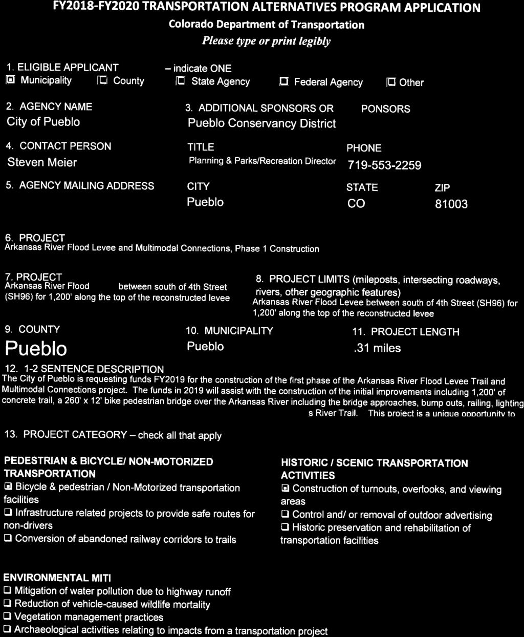


1
2
3 Attachment A Description of Project Arkansas River Flood Levee Trail and Multimodal Connections This application requests funding in 2018 to assist with the construction of the improvements including 1,200' of concrete trail, a 250' x 12' bike pedestrian bridge over the Arkansas River, bump outs, railing, lighting and seating areas. This project is a unique opportunity to partner with the Pueblo Conservancy District as part of the reconstruction of the 90 year old Arkansas River Flood Levee that extends for three miles through the center of the City of Pueblo. The reconstructed flood levee will have an average width of 40 along the top of the structure that will easily accommodate the project improvements. In addition a bike/pedestrian bridge will be constructed that will connect the flood levee trail with the existing Arkansas River Trail that extends from Fountain Creek for 10 miles to the base of Pueblo Dam within Lake Pueblo State Park. The existing Arkansas River Trail is part of the 25-mile Pueblo River Trails System. This project is within the designated corridor of the Colorado Front Range Trail which is part of the priority project area identified in Governor Hickenlooper s priority trail corridors. The project includes the following: Arkansas River Flood Levee Trail and Multimodal Connections This project is requesting FY2018 funds for the construction of the initial improvements along the top of the flood levee including a 1,200' of concrete trail, a 250' x 12' bike pedestrian bridge over the Arkansas River including the bridge approaches, bump outs, railing, lighting and seating areas. The Pueblo Conservancy District owns all of the property that is included within the project boundary and the City of Pueblo has a perpetual easement that allows for the construction, operation and maintenance of a bike/pedestrian trail, trailheads, and other recreation facilities on and across the Conservancy District s property. Arkansas River Flood Levee Trail and Multimodal Connections Description 1 Bike/Pedestrian Bridge 250 LF x 12 Wide - Single Span 2 Concrete Trail - 1,400 LF x 14 wide x 6 thick $10 per sq. ft. Cost $ 750, ,000
4 3 Access to Bike/Pedestrian Bridge 103,200 4 Trail Bump Outs 3 structures 10,000 SF concrete 240,000 ($80K each) 5 Railing 1400 LF 91,000 6 Lighting (8) 25 overhead lights & (6) pedestrian 192,000 lights 7 Trail Seating Lump Sum 27,800 Total Cost $1,600,000 Funding Sources City and Conservancy District Funds (15.5%) $ 250,000 Colorado Department of Local Affairs Energy Impact 400,000 Assistance Funds (25%) Great Outdoors Colorado Local Government Funds (22%) 350,000 Transportation Enhancement (37.5%) 600,000 Total Funds $1,600,000 Relationship of Project to Long-term Pedestrian/Bicycle Plans This project is identified as a high priority project for the City of Pueblo in the Pueblo Area Council of Governments 2040 Long Range Transportation Plan. In addition, this corridor is identified as a segment of the Colorado Front Range Trail that is planned to link between Ft. Collins to Pueblo passing through communities along the eastern toe of the Colorado Front Range. The Pueblo Conservancy District has included the development of a bicycle/pedestrian trail along the top of the levee with linkages to adjacent areas as part of their master plan that has been in place since the late 1990 s. Historic/Scenic Transportation Activities This project will provide for the initial construction of a bicycle/pedestrian facility along a 90 year old flood levee that is being reconstructed in order to receive certification under federal emergency management agency criteria. The flood levee was constructed 45 years prior to the Lake Pueblo Dam, and therefore did not incorporate the storage provided by Lake Pueblo to reduce the risk of flooding in Pueblo. Therefore as part of the reconstruction, the flood levee is being rebuilt an average of 12 lower than the original structure. This allows for the top of the levee to be increased from a width of 15 to 40 allowing for greater opportunities for the public to safely use the levee corridor for public access and viewing of the river and the historic sections of the City.
5 This project will provide for the initial construction of a bicycle/pedestrian facilities that will improve the ability for bicyclists and pedestrians to safely access the following facilities and commercial areas: 1. Arkansas River Flood Levee 2. Future phases of the project will provide access to adjacent neighborhoods and historic commercial areas.
6 Attachment B Maps, Plans and Photographs A vicinity map showing the City of Pueblo and the location of the project is included as Attachment B-1. A map showing the initial project construction area is included as Attachment B-2. Photographs are included showing the initial project construction area as Attachments B-3.


7 ARKANSAS RIVER FLOOD LEVEE AND MULTIMODAL CONNECTION PLAN Proposed Arkansas River Levee Trail Project Proposed Trail


8 Attachment B-2 Dorseys Way Dors eys Way Arkansas River Flood Levee and Multimodal Connections Phase 1 Construction Project Area Elm hu rst Pl E lm hu rs tp l W or on a W Co ro na Av e e at St H hw 96 Chapa P Chapa P l r Sumn e Ave Sumner Ave ve A ve Gal e Ab ri Av en d e o ve Ab l e A Levee Const rie ariver Arkasnas G Av n d e o AbPuebloTrailSystem Ab rie rie A n Av d b Av n d e o rie e o Av n d e o r le Ty St ± WC oron a Av e WC tte rde Bu ve A tte rde u B ve A e oron a Av e Ho Av e A war ve d ve on A Nels Ave n ls o Ne All ey Av e A ll ey Av A on il s W ve Ho wa rd on A Legend 0 l St Pear l St Pearl W il s Av e ig ay e C St Harvard Ave ve 0.11Harv ard A Fl o Av rida e Flor ida Av W h 4t W St h 4t Miles 0.22 Source: vesri, DigitalGlobe, GeoEye, Earthstar Geographics, CNES/Airbus DS, USDA, USGS, AEX, A e rv ar d Aerogrid, IGN, IGP, swisstopo, and the GIS User Community HaGetmapping,


9 1 Levee Trail view to NW from 4th Street Bridge 1 Levee Trail looking SE to I-25 2 Levee Trail view to NW from 4th Street
10 Attachment C Evidence of eligibility by Project Category Project Category 1: BICYCLE/PEDESTRIAN, NON-MOTORIZED TRANSPORTATION The Arkansas River Flood Levee Trail and Multimodal Connections planning and design project is eligible for funding as a bike/pedestrian, non-motorized transportation activity project. The planning and design of off-road trail facilities for pedestrians, bicyclists, and other non-motorized forms of transportation is an eligible activity under 23 U.S. C. 213(b). This planning and design project will develop a plan that includes bicycle infrastructure, lighting and other safety-related infrastructure, and design features that achieve compliance with the Americans with Disabilities Act of 1990 (42 USC et seq.). The planning and design project will identify infrastructure-related projects and systems that will improve safety for non-drivers, including children, older adults, and individuals with disabilities to access daily needs. Project Category 3: HISTORIC/SCENIC TRANSPORTATION ACTIVITIES As part of the planning and design features of this project the development of bump-outs, overlooks, and viewing areas will be identified along the top of the reconstructed flood levee for viewing the river and the historic commercial areas adjacent to the river. Relationship to Transportation The existing trail system is over 25-miles long and links the City s neighborhoods to several community destinations, such as: Lake Pueblo State Park, the Pueblo Nature Center, Zoo, City Park, the Arkansas River and Fountain Creek, Historic Arkansas Riverwalk of Pueblo, and the Pueblo Mall. The entire length of his section of the River Trail borders three of the City s lowmoderate income neighborhoods known as the Westside, Blocks, and the Grove which each contains a 50% Hispanic population. The need to provide safe neighborhood connectivity to the trail system is identified as a high priority in the PACOG 2040 Long Range Transportation Plan. (See Attachment D Benefits of proposed project List of Plans Documenting the Need and Support for the Project.)
11 Attachment D Benefits of proposed project This bicycle and pedestrian improvements included in this project will be developed along a 90 year old flood levee that is being reconstructed in order to receive certification under federal emergency management agency criteria. The flood levee was constructed 45 years prior to the Lake Pueblo Dam, and therefore did not incorporate the storage provided by Lake Pueblo to reduce the risk of flooding in Pueblo. Therefore as part of the reconstruction, the flood levee is being rebuilt an average of 12 lower than the original structure. This allows for the top of the levee to be increased from a width of 15 to 40 allowing for greater opportunities for the public to safely use the levee corridor for public access and viewing of the river and the historic sections of the City. This is a unique opportunity that will not be available in the future to work in partnership with the Pueblo Conservancy District to incorporate public bicycle/pedestrian improvements that are integrated with reconstruction of the flood levee structure. This project will focus on the initial 1,200 that is south of 4 th Street (SH96) along the top of the reconstructed Arkansas River Flood Levee. The project includes a trail, bridge across the Arkansas River that links with the existing Arkansas River Trail on the west side of the river, lighting, and bump-out/ overlook areas along the top of the flood levee. The existing Arkansas River Trail that is part of the 25-mile river trail system extending from Colorado State University-Pueblo to Lake Pueblo State Park, and to adjacent neighborhoods. A key component of this project is to complete the initial phase that will ultimately improve non-motorized connectivity within and adjacent to the city center of Pueblo. The project area is located within two census block groups (14001 and 35001) that meet the designated federal environmental justice criteria. This criteria contains the following socio-demographic characteristics: 1) Greater than 51% low-moderate income households; 2) Greater than 50% minority population; 3) 20% or greater disabled population; and 4) 10% of greater population with no motorized vehicles ( See attached Figure 3.19 map of Census Block Groups Meeting EJ Criteria). In addition, Census Block Group maps from Chapter 3 of the PACOG 2040 Long Range Transportation Plan showing lowmoderate income levels, minority population percentages, percentage of disabled populations, and percentage of families with no motorized transportation vehicles are included as attachments to the application. This planning project will focus on improving infrastructure and non-motorized activities that increase bicycling and walking, and improve connectivity from the
12 low income neighborhoods to the Rawlings Public Library, Pueblo Community Health Center, City government facilities, transit stops, and adjacent commercial areas. Based on the Built Environment/Active Living Scan November 2013 of Overweight and Obese Population in Colorado, Pueblo County has a 64.5% rating for obesity among its adult population. This is a rating that is higher than the average within the State of Colorado. Over the past 35 years the City of Pueblo and active citizen groups have developed an excellent trail system along our river and creek corridors. While this provides a great resource for the community and visitors, the most significant weak link identified is the lack of neighborhood connectivity to the trail system. This is especially prevalent along the Arkansas River with its steep bluff that borders the south side of the Arkansas River, the railroad yards, and the Arkansas River Flood Levee. Improving access from neighborhoods and connectivity with the downtown will be the most beneficial improvements that will increase bicycling and walking activities contributing to improved health and lowering the percentage of obese citizens in the Pueblo community. The Arkansas River Flood Levee Trail and Multimodal Connections project is identified in the planning documents as a high priority pedestrian/bicycle project. These documents are listed below and applicable pages are included as attachments to this application. These plans express the relevance of the project to the City and County s Regional Trail System. List of Plans Documenting the Need and Support for the Project - Pueblo Regional Transportation Plan year 2040 Pueblo Area Council of Governments, May Colorado Front Range Trail Comprehensive Implementation Plan, Pueblo Conservancy District Development Suitability Study, 1993
13 Attachment E Environmental Review As part of the planning and design project an environmental review will be completed that identifies environmental issues and concerns within the project area. The proposed project along the Arkansas River Flood Levee is being completed along the opposite side of the Arkansas River from previous trail improvements that have received environmental clearances completed by CDOT. Previous federal environmental clearances have also been completed for this section of the Arkansas River as part of the U.S. Army Corps of Engineers funded Arkansas River Fisheries Habitat Restoration Project constructed between 2004 and The previous environmental studies of this section of the Arkansas River included a review of endangered species, potential environmental hazards and a cultural analysis of the corridor. The environmental analysis indicated their were no known threatened and endangered species within the river corridor and no known environmental hazards or cultural or archeological sites identified within this section of the Arkansas River corridor. The results of this review are included within the Final Ecosystem Restoration Report and Environmental Assessment for the Arkansas River Fisheries Habitat Restoration Project, Pueblo, Colorado, September, In addition, the Arkansas River Trail, Phase 3 project, funded through the CDOT Transportation Enhancement Program in 2010 and constructed between also was subject to the required environmental clearances for the construction and upgrades of the river trail system on the west side of the Arkansas River across the river from the Arkansas River Flood Levee.
14 Budget and Implementation Schedule Attachment F Construction of the initial non-motorized transportation facility improvements along the top of the Arkansas River Flood Levee The total project cost for the Arkansas River Flood Levee Trail and Multimodal Connections is $1,600,000. Steven Meier, Director of Parks & Recreation/Planning & Community Development/Licensed Landscape Architect with the City of Pueblo prepared the project budget. The City is requesting a grant in the amount of $600,000 from the Transportation Alternatives Program to complete the project. Local matching funds in the amount of $1,000,000 will be provided by the City of Pueblo, Pueblo Conservancy District, Colorado Department of Local Affairs Energy & Mineral Impact Funds, and the Great Outdoors Colorado Trust Fund. The matching funds will be budgeted and appropriated by the City of Pueblo prior to the approval of a contract for the project. The local matching funds will total 62.5% of the total project costs. The funding information for the project is as follows: Construction Costs 1 Bike/Pedestrian Bridge 250 LF x 12 Wide $ 750,000 Single $120/sq. ft. 2 Concrete Trail - 1,400 LF x 14 wide x 6 thick reinforced $10 per sq. ft. 3 Access to Bike/Pedestrian Bridge $500 per LF 103,200 4 Trail Bump Outs 3 structures 10,000 SF concrete ($80K each) 5 Railing 1400 $65 per ft. 91,000 6 Lighting (8) 25 overhead $15,000 each & 192,000 (6) pedestrian $12,000 each 7 Trail Seating Lump Sum 27,800 Total Cost $1,600,000 Funding Sources City and Conservancy District Funds (15.5%) $ 250,000 Colorado Department of Local Affairs Energy Impact Assistance 400,000 Funds (25%) Great Outdoors Colorado Local Government Funds (22%) 350,000 Transportation Enhancement (37.5%) 600,000 Total Funds $1,600,000
15 Arkansas River Flood Levee Trail and Multimodal Connections APRIL 2016 Phase 2 - Construction of the initial non-motorized transportation facility improvements along the top of the Arkansas River Flood Levee PROJECT SCHEDULE PROJECT TASKS Oct-17 Sep-18 Oct-18 Mar- 19 GRANT NOTIFICATION SIGN CONTRACT NEPA REVIEW COMPLETE FINAL ENGINEERING COMPLETE BID PACKET ADVERTISE PROJECT BID OPENING AWARD PROJECT BEGIN CONSTRUCTION PROJECT COMPLETION CLOSEOUT PROJECT May- 19 Jun-19 Jul-19 Aug- 19 July-20 Aug- 20 Nov- 20
PLANNING AND NATURAL RESOURCES COMMITTEE. Public Access Conceptual Design Alternatives for the Red Barn Area of La Honda Creek Open Space Preserve
 PLANNING AND NATURAL RESOURCES COMMITTEE R-17-56 May 9, 2017 AGENDA ITEM AGENDA ITEM 2 Public Access Conceptual Design Alternatives for the Red Barn Area of La Honda Creek Open Space Preserve GENERAL MANAGER
Welcome to the. Open House
 Welcome to the 5th Street to Kinsman Road Open House November 14 5:30 7:00 p.m. Please sign in Project Overview In December 2016, City Council adopted SW 5th Street as the preferred alignment to connect
CITY OF SNELLVILLE GREENWAY MASTER PLAN
 CITY OF SNELLVILLE GREENWAY MASTER PLAN NOVEMBER 2017 This page intentionally left blank. INTRODUCTION Greenways are a hot topic in planning and urbanism circles. Many communities across Georgia and the
OVERMOUNTAIN VICTORY TRAIL BURKE CALDELL CORRIDOR FEASIBLITY STUDY REQUEST FOR QUALIFICATIONS CALDWELL COUNTY PATHWAYS
 OVERMOUNTAIN VICTORY TRAIL BURKE CALDELL CORRIDOR FEASIBLITY STUDY REQUEST FOR QUALIFICATIONS CALDWELL COUNTY PATHWAYS Caldwell County Pathways along with our co-partners City of Lenoir, Town of Gamewell,
Regional Open Space Conservation Plan. Regional Staff Committee January 18, 2018
 Regional Open Space Conservation Plan Regional Staff Committee January 18, 2018 Schedule We are here Task 1 - Stakeholder Input & Work Plan Dev. v z 2016 2017 2018 Oct Nov Dec Jan Feb Mar Apr May Jun Jul
November 2, 2015 at 5:15pm City Council Chambers, 3rd Floor, City Hall, 1737 Main Street Columbia, South Carolina 29201
 Subject Property: PLANNING COMMISSION SITE/SUBDIVISION PLAN CASE SUMMARY 10.21 ACRES, WESTSIDE OF CLIF KINDER BOULEVARD COTTAGES AT BURNSIDE FARM BURNSIDE FARMS ASSOCIATES, LLC November 2, 2015 at 5:15pm
BeltLine Corridor Environmental Study
 BeltLine Corridor Environmental Study Joint TAC and SAC Meeting December 8, 2008 What We Will Discuss Today Outreach and Agency Coordination Scoping Results Existing Conditions Historical and Archeological
2017 General Obligation Bond
 2017 General Obligation Bond Presentation of Public and Council Projects to the Transportation & Mobility Stakeholder Committee April 13, 2017 Agenda Deferred Maintenance Project Development Process Projects
A larger version of this map is located on the last page of this PDF.
 MAP Committee Input McLoughlin Area Draft Vision Map A larger version of this map is located on the last page of this PDF. 1. The map above is intended to portray a vision for the McLoughlin area. It highlights
Abingdon Urban Path System
 Abingdon Urban Path System Transportation Enhancement Program Application (FY 2012-2013) Submitted by: Town of Abingdon,Virginia P. O. Box 789 133 West Main Street Abingdon, VA, 24212 November 1, 2011
The University District envisions, in its neighborhood
 Envisioning the University District Link Light Rail in Seattle s neighborhoods CIY OF SEALE CONCEP-LEVEL SAION AREA PLANNING RECOMMENDAION RESOLUION # 30165 EXHIBI L Vision 08.2000 he University District
TOWN COUNCIL / PLANNING COMMISSION
 Workshop #3 TOWN COUNCIL / PLANNING COMMISSION January 20, 2011 Consultant Team In Attendance Tonight BMS Design Group Nevada City and San Francisco Michael Smiley, AICP, ASLA Partner-in-Charge Nancy L.
FY Capital Improvement Program Arroyo Projects - Lower Arroyo Summary
 LOWER ARROYO FY 214-218 Capital Improvement Program Description FY 213 FY 214 FY 215 FY 216 FY 217 FY 218 1 Bird Sanctuary Improvements (7749) 35, 225, 125, 2 Lower Arroyo - Implement Master Plan - Signage
Enhance the High Line Canal Projects
 Enhance the High Line Canal Projects Joint Project Proposal for Arapahoe County Open Spaces Funding Partner Sponsors: South Suburban Park and Recreation District City of Centennial City of Littleton October
TRAIL MASTER PLAN DRAFT. Broken Bow, Nebraska Adopted: Month, JEO Project No.:
 TRAIL MASTER PLAN DRAFT Broken Bow, Nebraska Adopted: Month, 2017 JEO Project No.: 161982.00 City of Broken Bow Mayor Cecil Burt City Council Members Rod Sonnichsen, President Neal Neth Chris Myers Jacob
CHAPTER 7: Transportation, Mobility and Circulation
 AGLE AREA COMMUNITY Plan CHAPTER 7 CHAPTER 7: Transportation, Mobility and Circulation Transportation, Mobility and Circulation The purpose of the Transportation, Mobility and Circulation Chapter is to
1.0 PROJECT PURPOSE AND NEED
 1.0 PROJECT PURPOSE AND NEED The FasTracks Plan includes the extension of the Central Corridor from its current terminus at 30th/Downing to a connection to the East Corridor commuter rail service planned
PARTF Scoring System for Grants
 PARTF Scoring System for Grants The members of the N.C. Parks and Recreation Authority use the PARTF scoring system as one of several tools to select grant recipients. Please provide all of the information
Community Open House March 26 th, 2018
 Community Open House March 26 th, 2018 Open House Agenda 1. Overview of Planning Process What we heard 2. Future Land Use Policy 3. Priority Growth Areas 4. Plan Elements Making it happen What is a Comprehensive
Kankakee River Bridge & Track Improvements Supplemental Environmental Assessment. May 5, 2016
 Kankakee River Bridge & Track Improvements Supplemental Environmental Assessment May 5, 2016 1 History: Chicago-St. Louis Corridor Since 1980 s IDOT has been looking at this corridor for high-speed service
BeltLine Corridor Environmental Study
 BeltLine Corridor Environmental Study Citywide Conversation on Transit and Trails April 2, 2009 Agenda & Introductions Introductions Environmental Study Process Overview of the BeltLine Project BeltLine
Great Rivers Greenway CLEAN GREEN CONNEC TED T RAILS
 Great Rivers CLEAN GREEN CONNEC TED T RAILS Great Rivers (GRG) was established in 2000 to create a clean, green, connected St. Louis region. Today, many new and exciting projects demonstrate the social,
Southeast Extension to RidgeGate Parkway Scoping Booklet
 Southeast Extension to RidgeGate Parkway Scoping Booklet PUBLIC SCOPING MEETING SCHEDULE Public Scoping Meeting Wednesday, November 2, 2011 6:00pm to 7:30pm City of Lone Tree Recreation Center Willow Room
Promoting Economic Development Through Upfront SEPA Review: Lessons from South Downtown Tacoma
 Promoting Economic Development Through Upfront SEPA Review: Lessons from South Downtown Tacoma 1 This session will focus on the City of Tacoma s South Downtown Subarea Plan and associated Non-Project SEPA
1.0 INTRODUCTION 1.1 TH 14 WEST STUDY AREA Project Description Functional Classification Purpose of the Project
 1.0 INTRODUCTION 1.1 TH 14 WEST STUDY AREA 1.1.1 Project Description The Trunk Highway (TH) 14 West Corridor is a two-lane roadway approximately 22 miles in length. Located in Nicollet County, the corridor
HOT SPRINGS COMPREHENSIVE PLAN OUTLINE
 HOT SPRINGS COMPREHENSIVE PLAN OUTLINE 7/28/2015 Draft outline - Hot Springs Comprehensive Plan Draft outline of topics to be discussed at public hearings and in planning sessions. Order and topics and
Por favor, levanten la mano si necesita traduccion en espanol Please raise your hand if you need Spanish translation
 FEDERAL BOULEVARD CORRIDOR WIDE STUDY PUBLIC MEETING #1 APRIL 27, 2016 Por favor, levanten la mano si necesita traduccion en espanol Please raise your hand if you need Spanish translation HDR DESIGN WORKSHOP
Wildflowers grow in the new community park on Oakwood Road
 Wildflowers grow in the new community park on Oakwood Road PLANNING AREA - NEW PARKS An important element in the plan for the City of Delafield is to look ahead for future park needs. The City has the
BUDGETING FOR OUTCOMES TRINITY RIVER CORRIDOR
 BUDGETING FOR OUTCOMES TRINITY RIVER CORRIDOR Trinity River Corridor Team Members: Kelly High, Streets Department Megan Lam, Office of Financial Services Mike Mikeska, Dallas Water Utilities Diana Ochoa,
BEST PRACTICES FOR PROJECT NOMINATIONS TA Set-Aside Program
 BEST PRACTICES FOR PROJECT NOMINATIONS 2017 TA Set-Aside Program Focus of this presentation Photos Public Support Maps & Exhibits Proposed Budget Design Details Project Evaluation & Selection Criteria
Green Infrastructure The Indianapolis Greenways Connection
 Green Infrastructure The Indianapolis Greenways Connection Fewer things in the transportation industry today make better since than combining the needs for pedestrian and bike trails with the need to locate,
WELCOME! 8 8:30 6: TH STREET IMPROVEMENTS. Open House. Presentation & Q&A
 WELCOME! 168 TH STREET IMPROVEMENTS 6:30 Open House 7 8 Presentation & Q&A 8 8:30 Open House WELCOME Todd Pfitzer City of Omaha Engineer Bob Stubbe City of Omaha Public Works Director Jon Meyer Project
FDOT D4 Complete Streets
 FDOT D4 Complete Streets Context Sensitive Solutions Directs that complete street solutions will complement the context of the community. Collaborative approach to decision making, project development,
City of Meriden Harbor Brook Flood Control Project Overview
 City of Meriden Harbor Brook Flood Control Project Overview Updated August 2013 OVERVIEW The center of Meriden, including the HUB site is the low point of the town which is ringed by basalt ridges. Running
Lake O the Pines Master Plan Revision Public Information Meeting April 25 & 27, 2017
 Lake O the Pines Master Plan Revision Public Information Meeting April 25 & 27, 2017 Presented By Matthew Like, Lake Manager U.S. Army Corps of Engineers Fort Worth District US Army Corps of Engineers
STP/SNK BIKE AND PEDESTRIAN PROJECTS
 STP/SNK BIKE AND PEDESTRIAN PROJECTS Project Name West Covington Riverfront Commons - Shared Use Path Applicant Name City of Covington, KY Applicant Title Mayor Joseph Meyer Email jumeyer@covingtonky.gov
Concord Community Reuse Project Goals and Guiding Principles. Overarching Goals (OG)
") Concord Community Reuse Project Goals and Guiding Principles Overarching Goals (OG) No priority is implied by the order of presentation of the goals and guiding principles. Overarching goals for the Concord
Concord Community Reuse Project Goals and Guiding Principles Overarching Goals (OG) No priority is implied by the order of presentation of the goals and guiding principles. Overarching goals for the Concord
Midtown Greenway PROJECT REPORT CARD
 Midtown Greenway PROJECT REPORT CARD Project Overview and History The Midtown Greenway is a 5.5-mile multi-use trail that connects the Mississippi River to the Minneapolis Chain of Lakes. The corridor,
Information for File # MMJ; Methodist Hospital Flood Storage Mitigation and Wetland Enhancement Project
 Information for File # 2016-01223-MMJ; Methodist Hospital Flood Storage Mitigation and Wetland Enhancement Project Applicant: Park Nicollet, Attn: Robert Riesselman Corps Contact: Melissa Jenny Address:
ARROYO PROJECTS ADOPTED CAPITAL IMPROVEMENT PROGRAM BUDGET
 A RROYO P ROJECTS ADOPTED CAPITAL IMPROVEMENT PROGRAM BUDGET FISCAL YEARS 214-218 HAHAMONGNA Priority Description 1 Hahamongna Watershed Park - Implement Master Plan 211,6 211,6 (77565) 2 Hahamongna -
City of Nogales General Plan
 Open Space, Parks, Recreation and Trails City of Nogales General Plan Residents of Nogales place a high priority in the development of a comprehensive system of open space, parks, recreation and trails
UNIVERSITY CITY AREA PLAN. Volume Two: Implementation Plan
 UNIVERSITY CITY AREA PLAN Volume Two: Implementation Plan Transforming the University City MSD into the vibrant, people-oriented place envisioned in the University City Plan will occur incrementally through
East Bench Master Plan Update
 Community & Economic Development Office of the Director East Bench Master Plan Update To: From: Planning Commission Wayne Mills, Senior Planner Date: November 18, 2015 CC: Re: Nora Shepard, City Planning
Glenborough at Easton Land Use Master Plan
 Vision Statement Sunrise Blvd. Hazel Ave. Prairie City Rd. Gencorp Property Lincoln Regional Airport 1.0 VISION STATEMENT The identifies City of the principles, goals, policies, and standards Lincoln that
Parks and Recreation Committee Agenda for the September 8th, 2014 meeting to be held in the Arena Board Room at 7pm
 Parks and Recreation Committee Agenda for the September 8th, 2014 meeting to be held in the Arena Board Room at 7pm 1) DECLARATION OF PECUNIARY/CONFLICT OF INTEREST AND GENERAL NATURE THEREOF - now or
Chapter 8. Visualizations
 Examples of Effective Techniques for Improving the Quality of Environmental Documents Chapter 8. Visualizations Visualizations help the reader to see what the project would look like in the real world.
RESOLUTION NO. R Refining the route, profile and stations for the Downtown Redmond Link Extension
 RESOLUTION NO. R2018-32 Refining the route, profile and stations for the Downtown Redmond Link Extension MEETING: DATE: TYPE OF ACTION: STAFF CONTACT: Capital Committee Board PROPOSED ACTION 09/13/2018
ADOPTED CAPITAL IMPROVEMENT PROGRAM BUDGET ARROYO PROJECTS
 ADOPTED CAPITAL IMPROVEMENT PROGRAM BUDGET ARROYO PROJECTS HAHAMONGNA FY 212-216 Capital Improvement Program Priority Description Total Estimated Costs Appropriated Through FY 211 Adopted FY 212 FY 213
Implementation Strategies
 An urban renewal plan for a stronger future for. Un plan de renovación urbana para un mejor futuro para. Implementation Strategies CAC Meeting September 21, 2016 TBD: An Urban Renewal Plan for a New Century
THREE-YEAR CAPITAL IMPROVEMENT PLAN FY
 THREE-YEAR CAPITAL IMPROVEMENT PLAN FY2016 2018 Annual CIP Development Process Public Works & Engineering Divisions Prepare List of Capital Needs and Recommended Deferred Maintenance Public Works & Engineering
Committee Meeting: Downtown Today & Concept Refinement September 11, 2017
 Committee Meeting: Downtown Today & Concept Refinement September 11, 2017 AGENDA 1. Brief Input Update 2. Comprehensive Plan Principles 3. Downtown Today 4. Concept Updates 5. Future Schedule What is a
Welcome to the Sellwood Bridge Project Pre-Construction Open House
 Welcome to the Sellwood Bridge Project Pre-Construction Open House 5:30 7:30 p.m. Please sign in here Information stations and project staff are located throughout the room. Goals for Tonight s Meeting
edmonton.ca/ribbonofgreen #ribbonofgreen
 WHAT IS THE RIBBON OF GREEN? The Ribbon of Green is Edmonton s entire river valley and ravine system. The Ribbon of Green (2018) Project will provide strategic guidance for the southwest and northeast
4 Park Planning and Design
 4 Park Planning and Design Park Constellations Elliot Gateway/Mills Loring North Loop Commons Twins Minneapolis Park & Recreation Board Downtown Service Area Master Plan 4-1 PROJECT APPROACH REFERENCE
Public Information Meeting
 Lavon Lake Master Plan Revision Public Information Meeting March 10, 2015 Presented By Michael Kinard Lake Manager U.S. Army Corps of Engineers Fort Worth District US Army Corps of Engineers Purpose of
Corridor Vision. 1Pursue Minnehaha-Hiawatha Community Works Project. Mission of Hennepin County Community Works Program
 1Pursue Minnehaha-Hiawatha Community Works Project Minnehaha-Hiawatha Community Works is a project within the Hennepin Community Works (HCW) program. The mission of the HCW program is to enhance how the
Atlanta BeltLine Corridor Environmental Study. Scoping Meeting August 2008
 Atlanta BeltLine Corridor Environmental Study Scoping Meeting August 2008 What Will We Be Discussing Today? Study Overview - How Did We Get Here? - What Is the Study About? - Who Is Involved? - Where Is
Mendota Heights 2040 Comprehensive Plan Draft Vers
 4 Parks and Trails The City of Mendota Heights boasts a variety of recreational and open space opportunities. Few cities can claim access to regional trails, riverside and lakeside parks, scenic bluffs
G A R Y G R E E N L I N K APPENDIX A
 G A R Y G R E E N L I N K M A S T E R P L A N 1 American Bridge Property data American Bridge Property Manager 2 Little Calumet-Galien River Watershed Study Applied Ecological Services, Inc. 3 Final Assessment
DISCUSSION TOPIC: ST JOHNS RIVER & ITS TRIBUTARIES (BPII) 2030 COMPREHENSIVE PLAN POLICES AND REGULATORY FRAMEWORK
 2030 COMPREHENSIVE PLAN POLICES AND REGULATORY FRAMEWORK") DISCUSSION TOPIC: ST JOHNS RIVER & ITS TRIBUTARIES (BPII) 2030 COMPREHENSIVE PLAN POLICES AND REGULATORY FRAMEWORK St. John s River & Its Tributaries Issue Summary: The St. Johns River is an important
DISCUSSION TOPIC: ST JOHNS RIVER & ITS TRIBUTARIES (BPII) 2030 COMPREHENSIVE PLAN POLICES AND REGULATORY FRAMEWORK St. John s River & Its Tributaries Issue Summary: The St. Johns River is an important
ROCHESTER INSTITUTE OF TECHNOLOGY Active Transportation Improvements 2010
 ROCHESTER INSTITUTE OF TECHNOLOGY Active Transportation Improvements 2010 In 2008, the Rochester Institute of Technology (RIT) completed a Comprehensive Parking and Transportation Study. Recommendations
Farmersville Parkway Phase III
 Farmersville Parkway Phase III Application to the TIGER VI Discretionary Grant Program April 2014 Submitted By: City of Farmersville 205 South Main Street Farmersville, Texas 75442 972-782-6151 TABLE OF
Sustainability, Health, Safety, Recreation & Open Space Working Group August 3, 2017
 Sustainability, Health, Safety, Recreation & Open Space Working Group August 3, 2017 DOWNTOWN OAKLAND SPECIFIC PLAN WELCOME Sustainability, Health, Safety, Recreation & Open Space Working Group Social
Plan-It Greenville (2009) Comprehensive Plan 5-Year Update
 Comprehensive Plan 5-Year Update") Plan-It Greenville (2009) Comprehensive Plan 5-Year Update What is the comprehensive plan: Collecting communitywide data Projecting future population growth Setting communitywide goals Framing policies
Plan-It Greenville (2009) Comprehensive Plan 5-Year Update What is the comprehensive plan: Collecting communitywide data Projecting future population growth Setting communitywide goals Framing policies
Planning Stage. Mosaic Park. Long Term Project. Restoration of 4 Mile Run. Planning Stage. Herndon and 13 th. Project Underway. Clarendon Central Park
 Planning Stage Long Term Project Planning Stage Project Underway Mosaic Park Restoration of 4 Mile Run Herndon and 13 th Clarendon Central Park Arlington County Parks, Recreation and Cultural Resources
Missing Link Study Grand Rounds Parkway Planning and Design Introduction
 Missing Link Study Grand Rounds Parkway Planning and Design Introduction June 19, 2007 Minneapolis Park and Recreation Board HNTB Hoisington Koegler Group Inc. Hess Roise 1 The Missing Link Study The Minneapolis
Mississippi Skyway Preliminary Engineering Report
 EXECUTIVE SUMMARY Mississippi Skyway Preliminary Engineering Report CITY OF RAMSEY, MINNESOTA DECEMBER 2014 City of RAMSEY EXECUTIVE SUMMARY Project Need and Intent The Mississippi Skyway pedestrian bridge
City of Missoula and Missoula County Open Space Planning Open House
 City of Missoula and Missoula County Open Space Planning Open House FEBRUARY 6, 2018 The following slides contain the display board content from the open house. Please use boards to answer questions in
STEERING COMMITTEE MEETING # 5 SEPTEMBER 18, 2018
 STEERING COMMITTEE MEETING # 5 SEPTEMBER 18, 2018 STEERING COMMITTEE MEETING #5 AGENDA 1. Introduction 2. Market Conditions 3. Preliminary Development Concepts 4. Open Discussion 5. Next Steps PLANNING
1 ESRI User Conference Eastside Greenway
 1 ESRI User Conference Eastside Greenway Grand Rapids, Michigan ~200,000 residents 45 sq. miles Leader in smart public investment Green infrastructure program ArtPrize BeerCity USA 2 ESRI User Conference
RECREATION AND OPEN SPACE ELEMENT GOALS, OBJECTIVES, AND POLICIES
 RECREATION AND OPEN SPACE ELEMENT GOALS, OBJECTIVES, AND POLICIES Goal 7 To provide park facilities, recreation programs, and open space resources that are safe, adequate, and accessible to all City residents,
Windsor Locks Transit-Oriented Development Planning Grant Request. Project Background
 Windsor Locks Transit-Oriented Development Planning Grant Request Project Background Downtown Windsor Locks runs along Main Street in the vicinity of the intersection of Routes 159 and 140. The current
495/MetroWest Development Compact Plan Citizen Planner Training Collaborative Conference. March 17, 2012
 495/MetroWest Development Compact Plan Citizen Planner Training Collaborative Conference March 17, 2012 Project Process Local and Regional Priority Areas Growth Scenarios Transportation Investment Categories
COASTAL CONSERVANCY. Staff Recommendation June 5, 2008 SAN DIEGO RIVER TRIBUTARY CANYONS PROJECT. File No Project Manager: Megan Johnson
 COASTAL CONSERVANCY Staff Recommendation June 5, 2008 SAN DIEGO RIVER TRIBUTARY CANYONS PROJECT File No. 08-059 Project Manager: Megan Johnson RECOMMENDED ACTION: Authorization to disburse an amount not
Lewisville Lake Master Plan Revision Public Information Meeting May 2 & 4, 2017
 Lewisville Lake Master Plan Revision Public Information Meeting May 2 & 4, 2017 Presented By Rob Jordan Lake Manager U.S. Army Corps of Engineers Fort Worth District US Army Corps of Engineers Purpose
I-84 Hartford Project Open Planning Studio #12. April 25, 2017
 I-84 Hartford Project Open Planning Studio #12 April 25, 2017 Meeting Agenda 1. I-84 Hartford Project alternatives update 2. Multimodal station area planning 3. I-84 / I-91 Interchange Study coordination
Northwest Rail Corridor and US 36 BRT Development Oriented Transit Analysis 4.4 STATION AREA FINDINGS
 4.4 STATION AREA FINDINGS Each station is different, and each one requires a separate set of recommendations based on the vision for the site. This section outlines an initial TOD strategy and recommendations
The Auburn Plan Designing the Future of Auburn February 28, 2005
 The Auburn Plan Designing the Future of Auburn February 28, 2005 Block-by-Block Bicycle Tour Aerial survey Focus Group Meetings September 7 and 8 Design Workshops October 11, 14, and 21 Revitalization
2011 ASLA Design Awards. Westside Creeks Restoration Plan Merit Award AECOM, Fort Collins. Planning & Urban Design
 2011 ASLA Design Awards Westside Creeks Restoration Plan Merit Award AECOM, Fort Collins Planning & Urban Design Project Fact Sheet Category of Entry: Rotating Specialty Award: 2011 2011 ASLA Colorado
40 Years of Smart Growth Arlington County s Experience with Transit Oriented Development in the Rosslyn-Ballston Metro Corridor
 40 Years of Smart Growth Arlington County s Experience with Transit Oriented Development in the Rosslyn-Ballston Metro Corridor A presentation by the Arlington County Department of Community Planning,
TO: Denver Planning Board FROM: Analiese Hock, Senior City Planner DATE: March 13, 2018 RE:
 Community Planning and Development Planning Services 201 W. Colfax Ave., Dept. 205 Denver, CO 80202 p: 720.865.2915 f: 720.865.3052 www.denvergov.org/cpd TO: Denver Planning Board FROM: Analiese Hock,
SECTION II SECTION II STATEMENT OF GOALS, OBJECTIVES, PRINCIPLES, ASSUMPTIONS, POLICIES AND STANDARDS
 STATEMENT OF GOALS, OBJECTIVES, PRINCIPLES, ASSUMPTIONS, POLICIES AND STANDARDS 1 2 STATEMENT OF GOALS, OBJECTIVES, PRINCIPLES, ASSUMPTIONS, POLICIES AND STANDARDS INTRODUCTION The New Jersey Municipal
Trail Feasibility and Planning Project for Northern Dutchess County, New York
 for Northern Dutchess County, New York Funded in Part by Grants from the Hudson River Valley Greenway, Land Trust Alliance Conservation Partnership Program and the Thomas Thompson Trust 1 STEERING COMMITTEE
Chapter 5: Natural Resources and Environment
 NATURAL RESOURCES AND ENVIRONMENT 5-1 5 Chapter 5: Natural Resources and Environment BACKGROUND AND INTENT Urban expansion represents the greatest risk for the future degradation of existing natural areas,
A BLUEPRINT FOR BROCKTON A CITY-WIDE COMPREHENSIVE PLAN
 A BLUEPRINT FOR BROCKTON A CITY-WIDE COMPREHENSIVE PLAN Public Meeting October 2016 1 Plan Summary and Discussion Public Meeting May 4 2017 City of Brockton Bill Carpenter, Mayor Department of Planning
Department of Community Development. Planning and Environmental Review Division Revised Notice of Preparation
 Department of Community Development Michael J. Penrose, Acting Director Divisions Building Permits & Inspection Code Enforcement County Engineering Economic Development & Marketing Planning & Environmental
MassDOT Highway ACEC State Markets Conference April 4, Jonathan Gulliver, Highway Administrator
 MassDOT Highway ACEC State Markets Conference April 4, 2019 Jonathan Gulliver, Highway Administrator About MassDOT Highway 9,561 Lane Miles of Interstate, Numbered Routes, and Toll Roads 60% of all trips
SELMON GREENWAY FEASIBILITY STUDY. For: Hillsborough County Metropolitan Planning Organization By: Renaissance Planning
 SELMON GREENWAY FEASIBILITY STUDY For: Hillsborough County Metropolitan Planning Organization By: Renaissance Planning SELMON GREENWAY FEASIBILITY STUDY VISION Multimodal connection between Bayshore Blvd
Oroville Area Urban Greening Plan. Joint Meeting of the Oroville Planning, Park, and Arts Commissions October 12, 2015
 Oroville Area Urban Greening Plan Joint Meeting of the Oroville Planning, Park, and Arts Commissions October 12, 2015 Project Team Lead Agency Butte County Department of Development Services Claudia Stuart,
Joe Pool Lake Master Plan Revision Public Information Meeting May 23, 2017
 Joe Pool Lake Master Plan Revision Public Information Meeting May 23, 2017 Presented By Jason Owen Lake Manager U.S. Army Corps of Engineers Fort Worth District US Army Corps of Engineers Purpose of this
1. Parks & Recreation Neighborhood Parks Community Parks Special Use Sites 2. Open Space 3. Trails
 Appendix A: Park Classifications The intent of parks and recreation classifications is to aid in making acquisition and design decisions for park sites, facilities and the organization of recreation space
People who are members of historically disenfranchised racial, ethnic, cultural, and other identity groups are encouraged to apply.
 CALL TO ARTISTS REQUEST FOR QUALIFICATIONS CITY OF TACOMA MUNICIPAL ART PROGRAM East 64 th Streetscape, Tacoma, WA APPLICATION DEADLINE October 10, 2018, 11:59pm BUDGET $72,000, all-inclusive SUMMARY The
DATE: October 25, Park, Recreation and Open Space Advisory Committee (PROSAC) Jordan Harrison, Planner III, RPD Planning Division
 Jordan Harrison, Planner III, RPD Planning Division") DATE: October 25, 2016 TO: FROM: RE: Park, Recreation and Open Space Advisory Committee (PROSAC) Jordan Harrison, Planner III, RPD Planning Division Possible Action on Potential Acquisition at Potrero
DATE: October 25, 2016 TO: FROM: RE: Park, Recreation and Open Space Advisory Committee (PROSAC) Jordan Harrison, Planner III, RPD Planning Division Possible Action on Potential Acquisition at Potrero
Arlington, Virginia is a worldclass
 EXECUTIVE S U M M A RY Arlington maintains a rich variety of stable neighborhoods, quality schools and enlightened land use policies, and received the Environmental Protection Agency s highest award for
GLX Project Green Line Extension Project GLX WORKING GROUP PRESENTATION OCTOBER 2, 2014
 GLX Project Green Line Extension Project 1 Agenda Welcome GLX Sustainability Project Overview & Updates Upcoming Public Meetings Station Meeting Lechmere Station Meeting Union Sq. & Washington St. Working
WLAC Facilities Committee Meeting. September 18, 2017
 Campus Program Report WLAC Facilities Committee Meeting September 18, 2017 Page 1 DSA approved the plans on May 15, 2017. Notice to Proceed was issued June 8, 2017 and the project remains on schedule for
Turkey Creek Corridor
 A NATURAL SANCTUARY Creek Corridor Creek Corridor.1 Kimberly BLOUNT ST CLAIR rro w sr Ro 79 oa 75 d A ad Pinson High School Jackson Creek Nature Preserve H B. D Pinson Dug Hollow Rd d o fo rl oo p er Rd
Welcome. Green Line LRT. Beltline Alignment Options. Stay engaged! Follow the Green Line story at calgary.ca/greenline
 Welcome Green Line LRT Beltline Alignment Options Stay engaged! Follow the Green Line story at calgary.ca/greenline Green Line LRT Why are we here? Our Challenge Determine the best alignment in the Beltline.
Gold Line Bus Rapid Transit Transit Oriented Development (BRTOD) Helmo Station Area Plan
 Helmo Station Area Plan") Appendix F Gold Line Bus Rapid Transit Transit Oriented Development (BRTOD) Helmo Station Area Plan Introduction and Purpose of the Plan The Gold Line Bus Rapid Transit facility is an eleven-mile dedicated
Appendix F Gold Line Bus Rapid Transit Transit Oriented Development (BRTOD) Helmo Station Area Plan Introduction and Purpose of the Plan The Gold Line Bus Rapid Transit facility is an eleven-mile dedicated
Michigan City Alternative Analysis Realignment Study. Progress Status Update Report Presentation to City Council February 1, 2012
 Michigan City Alternative Analysis Realignment Study Progress Status Update Report Presentation to City Council Project Web Site Project Web Site is Active www. emichigancity.com Click on NICTD logo at