Concept for Central Area and Pedestrian Street in Valga Valka Twin-Town Centre
|
|
|
- Sybil O’Brien’
- 5 years ago
- Views:
Transcription


1 Architecture competition task Concept for Central Area and Pedestrian Street in Valga Valka Twin-Town Centre Organized by: Valka Municipality Council Valga Town government
2 Content A. The task 1. The aim of the contest 2. Estonia-Latvia Program Valga and Valka 3.1. Location and area 3.2. History 3.3. Comprehensive plans of Valka and Valga 3.4. Identity and potential 4. Competition area and surroundings 4.1. Location 4.2. History 4.3. Buildings 4.4. Photos of the objects in the competition area & its surroundings 4.5. Film of the competition area 5. The task 5.1. General information 5.2. Main tasks 5.3. Specific tasks to design 5.4. Urban space requirement 6. The structure of proposals 6.1. Volume of the draft design 6.2. Form of the draft design 7. Assessment criteria B. Sources Valga Town development plan (Estonian) Valga Town historical heritage preservation statute (Estonian) Valka Town development program (Latvian) Valka District territorial plan (Latvian) C. Appendices of architecture competition task I. Topography of the competition area II. Ortho photo of the competition area III. Situation scheme of competition area IV. Photos of the objects in competition area & its surroundings V. Winning draft design of Architectural competition for Revitalization of Valga Historical Centre VI. The competition task scheme VII. Concept of Valka Valga Bikepark VIII. Approximate scheme of Valka bus station
3 A. The task 1. The aim of the contest The aim of the architecture contest is to find the best and most suitable design for the common public space, including a Central Area and a Pedestrian Street in the Twin-Town Centre of Valga-Valka. We want to gain a cozy and unique public area for our citizens and guests. We expect to have the Central Area for daily use with eventuality of a smooth transformation for different events like the Border Market, the Town Festival etc. We expect the new Pedestrian Street to connect Lugaži Church in the centre of Valka with Jaani Church in the centre of Valga. Both Central Area and Pedestrian Street should foresee space for small local businesses and for leisure time activities of citizens and guests, and thus revitalizing the Twin-Town Centre. The Authors of the best and most suitable proposal will be entitled to receive a contract for the technical project development. The contest is organized within the framework of the Estonian Latvian Cross- Border Cooperation Program Estonia-Latvia Program The objectives of the Estonia-Latvia Program project Valga-Valka Twin- Town Centre Development are: to improve the physical connectivity between Valga-Valka Town Centers to improve the accessibility of the labour market and increase cross-border mobility of employees and the self-employed to strengthen cooperation in fields of employment and social inclusion to develop common a business area for encouraging and attracting private investments and the establishment of new enterprises and jobs Investments in the public space of the Twin-Town Centre are one of the project activities.

4 3. Valga and Valka Valga-Valka ortho photo, Source: Estonian Land Board, 2015 Ø For photos in full resolution see Appendix II: Ortho photo of competition area Location and area The Twin-Town Valga Valka is located at the southern border of Estonia and the northern of Latvia. The town of Valga is the administrative centre of Valga County, and Valka is the administrative centre of Valka District as one of development centres in Latvia. The town of Valga covers 16,65 km2, the town of Valka 14,36 km2. Both towns are united by Pedele-Pedeli River. The state border between Latvia and Estonia runs along the Varžupīte-Konnaoja a creek of Pedele River, and therefore is a part of the project area. Valga has more inhabitants (2015), than Valka (2014) History Valga - Valka was first mentioned in It appeared in the credit register of the city of Riga, under the German name Walk. In 1584, Valga was granted a town charter and bylaws by Stefan Batory, King of Poland. In 1783, during the Regency of Catherine the Great, Valga County (Kreis Walk) was formed. The town went through a fast development period at the end of XIX and the beginning of XX century due to the establishment of a railway junction. In 1881, eight years before the Valga Railway Station was opened, the town population was 4200 inhabitants. By 1917, at the end of World War I, the population was already
5 In 1920, after the proclamation of independence of the Republic of Latvia and the Republic of Estonia, the town was divided between both countries and the border was set in the middle along the Varžupīte-Konnaoja Creek. Each country started to develop a new centre and the border area turned from the town centre into the outskirts. Also, due to the new political situation, the railway junction lost its importance and the population declined. During the Soviet occupation the physical border between the towns was nonexistent, but each part of the city continued on its own. The town became an important industrial centre with a large Soviet army military base. Due to that, the population of the Estonian part of the town grew between the years of 1939 and 1989 from to with the peak in 1979 ( inhabitants). The Latvian part followed a similar development. In 1991, after both countries regained independence, the border between Republic of Latvia and Republic of Estonia was re-established. The Soviet army left and industry went through structural changes. As a result of those processes both parts of the town lost a significant part of their inhabitants (Valga one third from its peak population). The populations of both Valka and Valga continue to contract. In 2004 Latvia and Estonia entered the EU and in 2007 joined the Schengen Agreement. The physical border between the two countries was eliminated and free movement between countries renewed. But the urban area of the border hasn t reacted to these changes Comprehensive plans of Valka and Valga The Municipality of Valka is currently working on a new territory plan of for the town of Valka, and in its current edition ( )the Project area is included in central building area. The central building area in a city or town, is an area that historically was developed for mixed use. Central building areas in territory plans are marked with the aim to promote various uses of these areas, to provide flexible development conditions for correlative and non-conflicting functions like business, public common areas and housing functions, but to limit intensive manufacturing and utility buildings. Preferably this area should be used for: residential (low storey apartment buildings and family homes), administrative, cultural, religious, health and social care, science and education institutions, business and office, trade and service buildings, sport activities, parks and Areas, public places. In Valga there is a valid comprehensive plan (introduced on 1 June 2007), which has been prepared by Tinter OÜ. The comprehensive plan foresees the general trends of land use in the town. This comprehensive plan enables the town extension with a lot of new development areas and thus is in strong contradiction with reality. At present the Valga town-government is working on a new, more suitable comprehensive plan.
6 The architectural competition is held in accordance with the fundamental principles of both town plans. There are two valid master-plans in the Valga part of the competition area, one for the Raja 5 plot, second for Raja 12. Both are more than five years old and thus may require changes Identity and potential The Twin-Towns Valga Valka motto is One city, two states to acknowledge Valga Valka as one common town for its inhabitants regardless of their nationality and whether or not they live to the South or North of the Estonia Latvia state border. The aim of the new Central Area and the Pedestrian Street is to support cross border activity and create a new common urban space re-connecting both parts of the town. Due to almost 90 years of separate development the Twin-Town Valga Valka overlaps in many infrastructure objects such as a sport arena, culture centre or music school with each state having its own. This enables the organization of large scale international events in otherwise comparatively small towns, and the new Central Area should support such activities. We aim to improve public knowledge of Valga - Valka as a cultural and commercial hub connecting the best of Latvia and Estonia. For every shrinking town question of local identity and interaction between each citizen and his hometown is a key issue. An unattractive, underused environment undermines such an interaction. As a result citizens are less active and less prepared to improve their environment and the shrinking process accelerates. With the renovation of the town centre in Valga - Valka we aim to stop the decline. We want to create a vibrant heart of the town that inhabitants can and will be proud of. 4. Competition area and surroundings 4.1. Location The competition area is the geographical centre of the twin town of Valga-Valka, which at the moment is a periphery of both towns. It lies on the state border and physically does not incorporate, but rather separates Valga and Valka. The current town centers are only a few hundred meters away from the planned joint town centre. The Planned Central Area is situated partly on the territory of both countries. As such it makes border crossing easier and enables the organization of festivities and markets in both countries simultaneously. Customers can profit from the market displays of both countries.
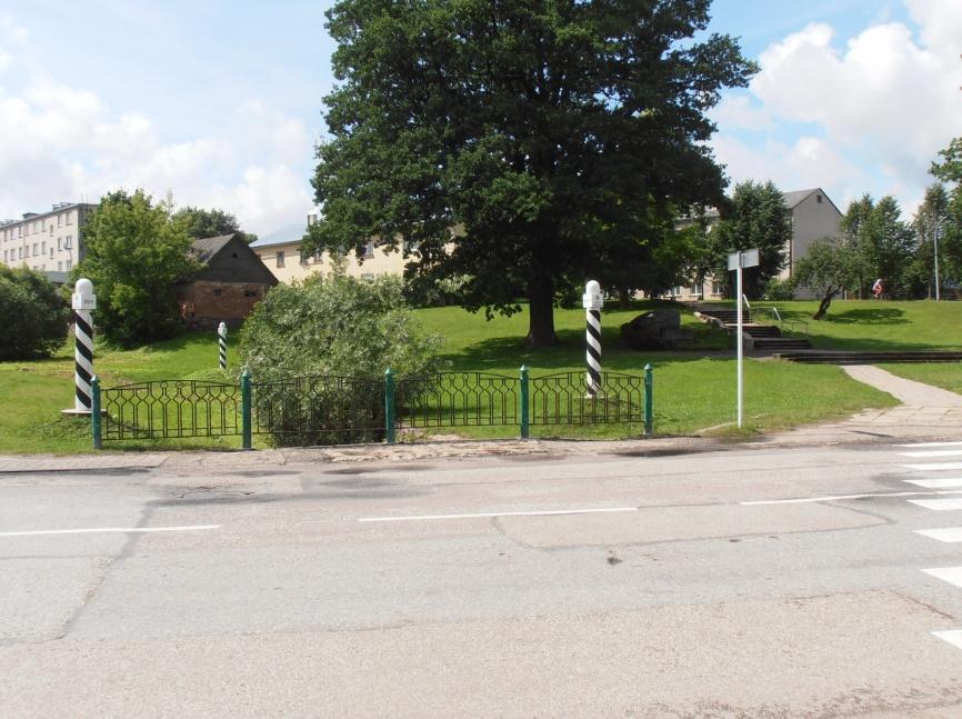
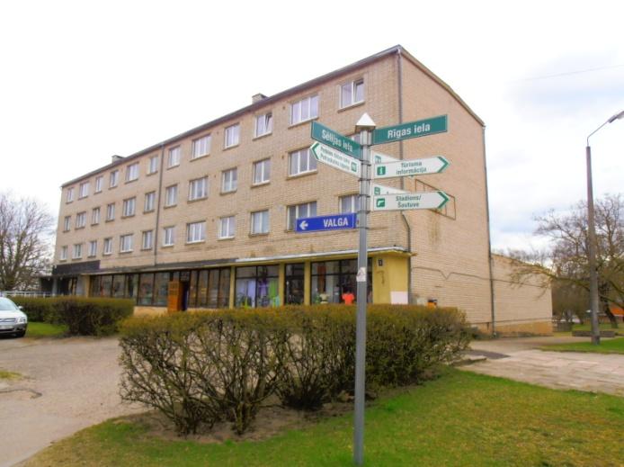
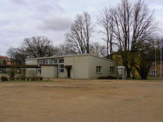
7 The area has a triangular shape limited by Raja-Tartu Street on the East, Rigas Street on the North-West and Raina-Sõpruse Street on the South. The Varžupīte-Konnaoja Creek divides the area into two parts while at the same time is the official Estonian- Latvian border. Both parts of the competition area are mostly flat, but at a different altitude. The difference in height between those parts is almost 2m (see Appendix II). The competition area on the North borders with the recreational area surrounding Pedele-Pedeli River History Varžupīte-Konnaoja Creek marked the border of the town of Valga-Valka already in the middle ages. The town of Valga- Valka territory was to the East of the Creek; to the West was the territory of Lugaži parish. As such, Jaani Church was the town church and Lugaži Church was the parish church. On the Valga-Valka plan dated 1683 a few buildings are on the both sides of the territory. Lugaži church is the oldest of them and the only one to survive till today. On a plan dated 1870, both territories were fully built-up. Most of the buildings were destroyed in World-War II or were demolished after. Almost all of the territory on the Estonian side of competition area was occupied by the Valga Winery. The Winery was demolished at the end of XX century before the construction of the Selver shopping centre. Only Winery tower was preserved Building On the Valga side, there are two shopping centers with their wide parking lots next to each other. Selver with abandonned former Winery tower is inside the competition area, while Rimi nearby is not. There is also a petrol station on the Selver parking lot. In close proximity to the project area is the historical centre of Valga with the former County (Kreis) Authority Building and the Roman Catholic Chapel, both under the heritage protection. The historical centre of Valga is undergoing renovation (see Appendix VI). The former Ramsi Watermill (under heritage protection, too) is on the riverside of Pedele-Pedeli (see Appendix III). Ø For more detailed information about the Valga historical centre see Appendix V: First place draft design of Architectural competition for renovation of Valga historical centre. On the Valka side of project area there is an underused marketplace with a pavilion. Next to this marketplace, there is the Valka Bus Station with the operating area for buses, and there are apartment blocks with their appendix buildings. The operating area for buses is larger than actually needed. On the West corner of the competition area, there is Lugaži Church and an office building with a bookstore (see Appendix III).


8 Ø For more detailed information about the area see Appendix III: Situation scheme of competition area. Appendix III: Situation scheme of competition area, Source: Authors 4.4. Photos of important objects in competition area and its surroundings 1. Valka Courthouse 2. Former Border Checkpoint


9 Years of Valga-Valka memorial 4. Residential building 5. Mixed use building 6. Valka Bus Station


10 7. Underused market pavilion 8. Bistro and hotel Jumis

 10.")


11 9. Valka Lugaži Church (under heritage protection) 10. Bookstore 11. Bus operating area (view from Raiņa and Latgales street crossing) 12. Residential building


12 13. Old Winery tower 14. Raiņa -Sõpruse Str. 15. Valga Jaani Church(under heritage protection)
 17.")
 18.")
 19.")
13 16. Former County (Kreis) Authority Building(under heritage protection) 17. Former Post Station (under heritage protection) 18. Bus station, market and shopping Centre Rimi (view from Lugaži Church tower) 19. Shopping Centre Selver with former Winery tower (view from Rimi roof)
 21.")


14 20. Petrol station (view from Rimi roof) 21. Roman Catholic Chapel (under heritage protection) 22. Apartment house on Sõpruse Str. 23. Valga historical centre with the view to Lugaži Church tower

 25.")

15 24. Former Ramsi Watermill (under heritage protection) 25. Border -post 26. National Geographic's yellow frame

16 27. Varžupīte-Konnaoja Creek Ø For photos in full resolution see Appendix IV: Photos of important objects in competition area or its surroundings Film of the competition area You can follow this link to a film of the competition area: 5. The task 5.1. General information The architecture contest is part of a larger project which is supposed to create a joint business incubator to support and encourage local entrepreneurship and traditional and local resource based services local food and handicrafts. We are looking for the best possible solutions for the development of Valga-Valka and the Estonian-Latvian border area. We expect to have the Central Area for daily use which can be easily adapted for different events like the Border Market, the Town Festival etc as needed. We expect new the Pedestrian Street to connect Lugaži Church in centre of Valka with Jaani Church in centre of Valga. The aim of the new Central Area and the Pedestrian Street is to support cross border activities and to create a new common urban space re-connecting both parts of the town. We want to create a vibrant heart of the town that its inhabitants can be proud of. We aim to improve public knowledge of Valga - Valka as cultural and commercial hub connecting the best of Latvia and Estonia. The fact, that the area includes a flowing water source (border creek) and its landscape is not flat, but includes the creek s banks at different heights, makes the area attractive for a creative and an attractive architectural solution. This attractiveness is even more underlined by the area`s location on the international border, while at the same time, in the centre of this twin town.

17 Ø For more detailed information see Appendix VI: The competition task scheme. Ø Appendix VI: The Competition task scheme, Source: Authors
18 5.2. Main tasks To design a multifunctional cross-border Central Area on the border of Estonia and Latvia including an area for open-air markets and festive events, playgrounds, innovative lighting systems, original urban space, furniture etc. To design a Pedestrian Street linking the churches in both town centers. The new Pedestrian Street should open the possibility for small businesses such as cafeterias, restaurants, different services, etc. This should re-activate the underused buildings along the street. To design new options for crossing the border at the new cross-border Central Area, thus giving the opportunity to break the border in peoples minds, also. New crossings will unite the two towns on the border and improve the cooperation between Estonia and Latvia, as well To design an attractive area along the banks of Varžupīte-Konnaoja Creek, linking this revitalized green area with the actual greenway along Pedeli River river, which crosses the border, also. To link actual buildings in the competition area with the newly established cross-border Central Area and Pedestrian Street with the goal to attract entrepreneurs to the area. To propose ideal functions for those buildings Specific tasks to design relief and pavement (Dignified, maintenance-free and durable pavement, which supports a variety of uses. Pavement should be designed as weather resistant and in accordance with the planned use.) small scale resting-places, outdoor lounges sculptures or any other interesting and attractive/interactive objects permanent trading places in the market area (6-10 counters, preferably removable) multifunctional building m2 to support trading and local community`s events and activities, including public toilets (reconstruction of underused market pavilion is optional) reservation for future extension of the "Selver" shopping center up to 3060 m2. One of possible solutions is marked on the competition task scheme. opportunity for extension of the Rimi shopping centre traffic solution for Valka bus station operation area. Safe and convenient entry and departure from the territory for transport as well as for pedestrians need to be ensured. Maximum bus size is 2.55 x m. Transport operating area can decreased up to 50% of existing bus operating area. The rest of area can be used for Valga Valka Central Area needs. New buildings are not allowed on the territory of bus station. At least two departure platforms, one arrival platform and parking with 4 places need to be designed (see Appendix VIII. Approximate scheme of Valka bus station). Platforms needs to be as
19 close as possible to existing building of Valka bus terminal. Building of Valka bus terminal need to be preserved but it can be redesigned and new function for building can be provided. Area for booking-office must be kept inside the building. supply solution for the Selver shopping centre. The Supply trucks are 14m long and their turning radius is 10m. The loading bay is on western façade of the shopping centre and trucks travel through Sõpruse street. After the future extension of the shopping centre, the centre will be supplied via the new part of the building. The possible truck route is from Raja Street through Sõpruse street inside the new part of the shopping centre and then through the shopping centre parking lot to the crossroads of Raja and Riia streets. parking solution for the Selver shopping centre (so that in case of big events the area can be used for another purpose). The capacity of parking lot should be around 90 cars. parking solution for the Rimi shopping centre parking solution for visitors temporary parking solution for big events urban space lighting principles, lighting of important buildings, objects permanent or removable stage for cultural events sound playback solution for events information stand about the twin town of Valga-Valka design of green areas possible replacement of the National Geographic s yellow frame from Raja 12 plot to better place swing over the border. A traditional Latvian and Estonian village inspired swing can be placed somewhere directly over the border. location for a Bikepark. If suitable within the overall design of the territory (see Appendix VII: Concept of Valka Valga Bikepark)a bikepark can be proposed inside of the competition area or inside the contact area Urban space requirement The area on both sides of border creek (Varžupīte-Konnaoja) must be easily transformable so that on a daily basis it is of a scale comfortable for local citizens, but also, so that big events and festivals can be organized there, (with extra space for trading and craftsman, a small stage for leading events, concerts). We expect solutions for year-round usage of the area. Priority should be on the re-development of actual buildings but if needed, new buildings can be modestly added. Also, the area should be still functional in case the new buildings are not erected. To resolve passages to the competition area from all the surrounding streets. To respect the topographical height differences of the area
20 To respect needs of people living in or nearby the competition area. Designed in accordance with accessibility requirements The actual border-posts are fixed by international agreement and as a such they can not be removed. Full visibility between border-posts need to be preserved. If necessary, border have to be possible to close. Mobile or removable barriers should be designed on the top of possible coverage of border creek. 6. The structure of proposals 6.1. Volume of draft design Draft design has to include: 1. Graphic material (unlimited amount of display boards in A1 size) which includes: Schemes of functional and urban connections in the competition area with its surroundings Competition area plan using topography in scale 1:500 with marked: - Functional use of area - Topography and pavement of area - Transport and parking solution - Greenery - Placement of urban space inventory - Lightning Characteristic sections Design concept for urban space inventory Visualizations ( at least three 3D pictures which give an overview of the proposed solutions) 2. Explanatory note (A4 size) which includes: Short description of design idea formation Short description of functional use of area Short description of greenery Transport and parking solution Urban space inventory description 6.2. Form of draft design The form of the draft design needs to be composed in accordance with the following conditions: Graphic elements (drawings, diagrams, visualization, etc.) must be submitted on display boards and preferably under the rigid horizontal A1 format. Text elements (explanatory note, text appendixes, etc.) shall be presented in A4 format bound sheets.
21 All the information must be handed in printed form and digitally CD or any other information medium.doc,.xls,.pdf or.jpg format in logical understandable order. 7. Assessment criteria Architectural, compositional and visual quality of proposal. Functionality and compliance with the architecture competition task. Integrity and environmental suitability of the proposal. Practicability and feasibility of the proposal (the cost efficiency over the lifetime of the object, the feasibility of the solution, etc.). Composed in 2015 by: Jiri Tintera, authorized architect, Valga Town architect Jolanta Kriviņa, Landscape architect, Valka Municipality Council
RIGA LATVIA. KEY FEATURES OF THE CITY Demographic Facts. Urban Figures. Heritage. EXISTING GOVERNANCE MECHANISMS Development and Management Plans
 RIGA LATVIA KEY FEATURES OF THE CITY Demographic Facts around 700.000 inhabitants in the city 1.15 million people in the Riga region Urban Figures the medieval core of the Old Town the 19th century grid
,,XIX century was the age of empires, XX century the age of states, XXI century becomes the age of cities. Wellington E. Webb, Mayor of Denver
 ,,XIX century was the age of empires, XX century the age of states, XXI century becomes the age of cities Wellington E. Webb, Mayor of Denver 1 VILNIUS : FACTS & FIGURES 16 million inhabitants in a 300
The ACTION PLAN OBJECTIVES, POLICIES, ACTIONS
 The ACTION PLAN OBJECTIVES, POLICIES, ACTIONS Responsible actors Key actors Funds needed and funding sources available OBJECTIVE 1 Strengthening the governance and the social capital through the development
Zagreb. Strategic planning. City of Zagreb City Office of Strategic Planning and Development of the City
 Zagreb http://www.zagreb.hr/ Strategic planning Through ZAGREBPLAN a vision of Zagreb was defined: City of Zagreb as an urban incubator of sustainable concepts, entrepreneurship and new values City of
SUMMARY OF PILOT PROJECT IMPLEMENTATION PHASE
 SUMMARY OF PILOT PROJECT IMPLEMENTATION PHASE Project /Title: Forest Park Renewal activity 4.2.2 Site (region/city or town): at street Raisova in Brno Nový Lískovec, city district of Brno city, Czech republic
Page 1 of 19 URBAN DESIGN FRAMEWORK FOR BOLTON STREET WATERFORD
 Page 1 of 19 URBAN DESIGN FRAMEWORK FOR BOLTON STREET WATERFORD 1.0 Introduction: The relocation of the City Council stores and depot from Bolton Street creates an exciting opportunity for development
1. Introduction to Linköping
 INTERREG IVC - Project "Hybrid Parks" Partner 5: Linköping Municipality Environment and Community Development Department Situation Report, April 2012 1. Introduction to Linköping Linköping is Sweden s
The proposals presented in September drew a large number of comments and feedback and have been grouped together as follows:
 Appendix A Stakeholder presentation + powerpoint slides Planning Context and Emerging Proposals presentation Nick Tyrrell, Alder King, Planning Consultants Alder King began by setting the site context
13. London Bridge London Bridge Area Vision
 13. 13.1. Area Vision 13.1.1. is: A globally significant central London business district which is home to international business headquarters; Internationally renowned for its prominent riverfront location
Workshop on plaster conservation April 2003, St. Mary s church of Pöide, Estonia. Report
 Workshop on plaster conservation 22-27 April 2003, St. Mary s church of Pöide, Estonia Report National Heritage Board Tallinn 2003 I CONTEXT St. Mary s church of Pöide was in constant use until 1940 when
ALMATY TRAM DEPOT. Turning the former into a sustainable space.
 ALMATY TRAM DEPOT. Turning the former into a sustainable space. Introducing the city of Almaty ALMATY 700 sq.km 1.7 mln. «Almaty-2020» City Development Program VISION: The modern city of an international
28. Coolaney-Rockfield Mini-Plan
 28. Coolaney-Rockfield Mini-Plan 28. Coolaney-Rockfield Mini-Plan Community facilities Community facilities in Coolaney-Rockfield consist of a primary school, crèche, community centre, sports field and
Arlington, Virginia is a worldclass
 EXECUTIVE S U M M A RY Arlington maintains a rich variety of stable neighborhoods, quality schools and enlightened land use policies, and received the Environmental Protection Agency s highest award for
Making the case for Sustainable Transport Project Potential
 Making the case for Sustainable Transport Project Potential The Structural Investment Fund (SIF) Strategy for Greater Lincolnshire identifies the barriers to growth identified by having poor transport
CHRISTELER Stéphane URBAN GROWTH WITHOUT SPRAWL: FOUR EXAMPLES IN THE GENEVESE REGION
 CHRISTELER Stéphane URBAN GROWTH WITHOUT SPRAWL: FOUR EXAMPLES IN THE GENEVESE REGION INDEX 1) Issues of urban densification 2) Perceptions of the urban densification 3) The consequences of urban densification
COUNCIL OF EUROPE LANDSCAPE AWARD EUROPEAN LANDSCAPE CONVENTION
 COUNCIL OF EUROPE LANDSCAPE AWARD EUROPEAN LANDSCAPE CONVENTION FOURTEEN COUNCIL OF EUROPE MEETING OF THE WORKSHOPS FOR THE IMPLEMENTATION OF THE EUROPEAN LANDSCAPE CONVENTION Council of Europe Landscape
Market Place Bythell Place Queen Street Park Riverside Park. Public Spaces. Blenheim CBD Streetscape Final Report 36
 37 39 41 43 Market Place Bythell Place Queen Street Park Riverside Park Final Report 36 Market Place Market Place is a key space for Blenheim s street life, it is a meeting place, retail edge and pedestrian
Ecological Reflection on the Current Development of Mainland
 Ecological Reflection on the Current Development of Mainland China s Urban Waterfront: a Case of Wuhan In the 21st century, urban waterfront construction is a hot issue of mainland China s urban development.
SUSTAINABLE URBAN DEVELOPMENT INVESTMENT PROGRAM FOUR YEARS OF PROGRESS
 SUSTAINABLE URBAN DEVELOPMENT INVESTMENT PROGRAM FOUR YEARS OF PROGRESS Yerevan is the economic, scientific and cultural center of the Republic of Armenia. It is considered as the major regional transportation
Good education Good living Green future
 D66 Groningen - english summary of the election programme - 2018-2022 Good education Good living Green future Together we make Groningen Highlights 2 Groningen has many things to offer: a vibrant cultural
Arlington County Retail Plan
 Arlington County Retail Plan Draft April 28, 2015 EXECUTIVE SUMMARY Arlington will be a community where retail is convenient, appealing, activating and sustainable; that provides interest and authenticity,
GREENFORD HALL & ADJOINING LAND
 GREENFORD HALL & ADJOINING LAND CONTENTS 1. Introduction 1. Introduction 2. Urban Context 2.1 The Site and Surroundings 2.2 Urban Context Map 2.3 Access and Movement 3. Planning Context 3.1 Planning History
Orcasur Market. Madrid Plaza del Pueblo-Avenida de Orcasur
 Orcasur Market. Madrid Plaza del Pueblo-Avenida de Orcasur The proposed site is a local market located on a plot of 1,880 m2 in the Orcasur neighbourhood, in the Usera district. Situated in the south of
Urban Design Brief Woodland Cemetery Funeral Home 493 Springbank Drive
 Urban Design Brief Woodland Cemetery Funeral Home The Incorporated Synod of the Diocese of Huron April 15, 2016 Urban Design Brief April 15, 2016 TABLE OF CONTENTS Page No. INTRODUCTION... 1 SECTION 1
A DYNAMIC CITY AND ITS ASSETS
 A DYNAMIC CITY AND ITS ASSETS Great new urban projects are being completed Significant funding for public realm upgrades in the commercial core Population growth and skills on the rise Growing internal
Mark-up of the effect of the proposed Bronte Village Growth Area OPA No.18 on the text of section 24, Bronte Village, of the Livable Oakville Plan
 Mark-up of the effect of the proposed Bronte Village Growth Area OPA No.18 on the text of section 24, Bronte Village, of the Livable Oakville Plan Notes: This document is provided for information purposes
BLETCHLEY PARK AREA - DEVELOPMENT FRAMEWORK
 ANNEX A To Item 9 REVISED TEXT: additions shown bold and underlined, deletions in (brackets and in italics). BLETCHLEY PARK AREA - DEVELOPMENT FRAMEWORK This framework sets out the key objectives and requirements
Colchester Northern Gateway Master Plan Vision Review Draft. July 2016
 Colchester Northern Gateway Master Plan Vision Review Draft July 2016 Contents Introduction 4 Context 8 Purpose of the Report 8 Strategic Position 9 Overview of the Process 11 2012 Master Plan Vision 12
THE ARCHITECTURAL POLICY OF ESTONIA. Passed at the Parliamentary sitting , protocol no. 43, item no. 5
 THE ARCHITECTURAL POLICY OF ESTONIA Passed at the Parliamentary sitting 22.10.2002, protocol no. 43, item no. 5 THE ARCHITECTURAL POLICY OF ESTONIA With the development of a market economy the responsibility
NEW CENTRE OF ŁÓDŹ OPERATION ON AN OPEN CITY
 NEW CENTRE OF ŁÓDŹ OPERATION ON AN OPEN CITY 1. Łódź in Europe POPULATION 725 thousand of inhabitants in Łódź Łódź is big and growing academic city: 25 higher education institutions, over 100 thousand
K. SMART ASSOCIATES LIMITED
 Planning Justification Report Zoning By-Law Amendment 185 King Street North Waterloo, Ontario April 7th, 2017 Project Reference Number 16-245 K. SMART ASSOCIATES LIMITED CONSULTING ENGINEERS AND PLANNERS
NEW VISIONS OF URBAN POLITICS MEDIUM-SIZED EUROPEAN CITIES IN THE 21 ST CENTURY MAY 14-16, 2014, OLOMOUC, CZECH REPUBLIC
 NEW VISIONS OF URBAN POLITICS MEDIUM-SIZED EUROPEAN CITIES IN THE 21 ST CENTURY MAY 14-16, 2014, OLOMOUC, CZECH REPUBLIC The Green City as Model for Cities in CEE? Sustainable urban development strategies
STUDY CAMPUS OF THE LITHUANIAN ACADEMY OF MUSIC AND THEATRE
 STUDY CAMPUS OF THE LITHUANIAN ACADEMY OF MUSIC AND THEATRE SUMMARY OF THE COMPETITION BRIEF The content of this Summary corresponds to the essence of the official Competition Brief, but doesn t present
Elodie Gonthier (Team leader) Kevin Ramirez Sandra Velasco Krishna Chandran Anna Aghvanyan Sirin Hamsho
 Kevin Ramirez Sandra Velasco Krishna Chandran Anna Aghvanyan Sirin Hamsho") 2 T he nature of today s global economy highlights our interdependence and the need for much better global policies. Inspiring Technovation is pleased to present its report on transforming the city of
2 T he nature of today s global economy highlights our interdependence and the need for much better global policies. Inspiring Technovation is pleased to present its report on transforming the city of
Employment and Commercial Review Analysis of Policy Directions
 Employment and Commercial Review Analysis of Policy Directions Appendix A The following analysis is town staff s response to the policy directions provided by the consultants who prepared the Employment
The Town of Chrudim With Local Agendou 21 Towards Higher Quality of Life Whole City Awards
 The Town of Chrudim With Local Agendou 21 Towards Higher Quality of Life Whole City Awards Chrudim is an old town (the first written mention dates back to 1055) with a rich history and numerous cultural
Leaders Study Retreat + World Architecture Festival
 Smart Cities & Urban Innovations Study Tour Leaders Study Retreat + World Architecture Festival Berlin 2016 : November 13-18 th 4 days 40 Speakers 1 Architecture Cruise 1 Networking Receptions 8-10 Site
1 October Dear Citizens of Charlotte and Mecklenburg County,
 1 October 2011 Dear Citizens of Charlotte and Mecklenburg County, As co-chairs of the Center City 2020 Vision Plan Steering Committee, we are proud to present the Center City 2020 Vision Plan, which sets
City of Kingston. North King s Town Secondary Plan Open House + Workshop #1 February 28, 2018
 City of Kingston North King s Town Secondary Plan Open House + Workshop #1 February 28, 2018 1 event agenda 30 min Panel Review + Discussion 30 min Presentation + Q&A 75 min Workshop Session 15 min Report
Comprehensive Plan. Faribault, Minnesota. Hoisington Koegler Group Inc. Claybaugh Preservation Architecture Inc. Howard R. Green Company Bonz/REA
 Comprehensive Plan Faribault, Minnesota Adopted by the Faribault City Council July 8, 2003 prepared for: prepared by: Hoisington Koegler Group Inc. Claybaugh Preservation Architecture Inc. Howard R. Green
KANATA CENTRUM 255 KANATA AVENUE OFFICIAL PLAN AMENDMENT ZONING BY-LAW AMENDMENT
 KANATA CENTRUM 255 KANATA AVENUE OFFICIAL PLAN AMENDMENT ZONING BY-LAW AMENDMENT JUNE 2015 PREPARED BY: FOTENN Consultants Inc. 223 Mcleod Street Ottawa, ON K2P OZ8 (613) 730-5709 PREPARED FOR: Kanata
Public Realm: Publicly accessible streets, footpaths, parks, squares, bridges, public buildings and facilities.
 Welcome Introduction Welcome to the public consultation process for the Draft Ballinrobe Public Realm Plan. These presentation panels explain the findings of the process and a series of draft projects
TEMPLE MEDICAL & EDUCATION DISTRICT
 City of Temple, Texas TEMPLE MEDICAL & EDUCATION DISTRICT 1 Description. The City of Temple joined in partnership with key public and private entities to jointly promote education and medical activities
16. Peckham Peckham Area Vision
 16. 16.1. Area Vision 16.1.1. is: A lively town centre providing a range of daytime and night time activities on Rye Lane including a Library, a Leisure Centre and many independent retailers which specialise
Anne Sandelin City of Jyväskylä Urban Planning Projects
 Anne Sandelin City of Jyväskylä Urban Planning Projects The main urban development project of Jyväskylä for the next decades Old paper mill (27 ha) is located app. 0,7 km from the city center Kangas City
Introduction. Community Outreach Approach. Sacramento Valley Station Master Plan. Online Questionnaire Summary of Feedback.
 Introduction Located in the northwest sector of downtown Sacramento, the Sacramento Valley Station (SVS) is the primary rail station in northern California and the seventh busiest station in the country.
EA527. leeuwarden (nl) urban prescriptions 1/6
 urban prescriptions 1/6") 1/6 We propose a series of that can be implemented beyond the project area. A catalog which can be exported to urban environments with similar problems and opportunities as in Leeuwarden. Prescriptions
1/6 We propose a series of that can be implemented beyond the project area. A catalog which can be exported to urban environments with similar problems and opportunities as in Leeuwarden. Prescriptions
BEIT SAHOUR OLD TOWN : A CORNER OF CULTURE
 BEIT SAHOUR OLD TOWN : A CORNER OF CULTURE 1. Context The city of Beit Sahour holds a huge legacy of customs and traditions due to its origins going back to the Bronze Age (3000 B.C.). The Canaanites inhabited
Outline of Presentation
 LUSAKA CITY COUNCIL 2 nd Annual IGC Cities Conference Making Cities work for growth London School of Economics (LSE) United Kingdom. 28 th 29 th January 2016 Presenter: Alex Mwansa Town Clerk Lusaka City
SIBBESBORG COMPETITION
 1/4 FOR SUSTAINABLE COMMUNITY DEVELOPMENT SIBBESBORG COMPETITION OVERALL PLAN 1:15000 Principles of the design and the path to realisation History reborn. The proposal is constructed on the history of
17. Coolaney-Rockfield Mini-Plan
 County Development Plan 2017-2023 Consolidated Draft + Adopted Amendments - August 2017 17. Coolaney-Rockfield Mini-Plan Village profile Coolaney is located approximately 23 km to the south-west of Sligo
BORRISOKANE SETTLEMENT PLAN
 BORRISOKANE SETTLEMENT PLAN 1.0 General Introduction and Development Context Location Borrisokane is located 15km north of Nenagh on the N52. While the town is primarily residential, it acts as a market
SECTION ONE: INTRODUCTION. introduction
 introduction 1 INTRODUCTION Since it was first established in 1843 as a trading post for the Hudson s Bay Company, Victoria has evolved into a Provincial capital city that is recognized across Canada and
Welcome to our public exhibition
 About Our Scheme Welcome to our public exhibition This exhibition gives you the chance to view and comment upon our emerging proposals for a new residential development of 68 new homes on the site of the
Former North Works, Lickey Road, Longbridge, Birmingham
 Committee Date: 14/11/2013 Application Number: 2013/06431/PA Accepted: 27/08/2013 Application Type: Full Planning Target Date: 26/11/2013 Ward: Longbridge Former North Works, Lickey Road, Longbridge, Birmingham
3.1 Existing Land Use
 3.0 Land Use This strategy has been developed taking into account the position of the Town of Sidney as the economic center of the Saanich Peninsula. It acknowledges existing land use patterns in the downtown
2002/ Modernisation Road N 4
 2002/000-606.02 - Modernisation Road N 4 1. Basic Information 1.1. CRIS Number 2002/000-606.02 1.2. Title: Modernisation of the national road No 4 1.3 Sector : Cross Border Co-operation / Infrastructure
URBAN DESIGN BRIEF. 2136&2148 Trafalgar Road. Town of Oakville
 URBAN DESIGN BRIEF 2136&2148 Trafalgar Road Town of Oakville Prepared By: METROPOLITAN CONSULTING INC For 2500674 Ontario Inc November 2016 TABLE OF CONTENTS Page No. 1.0 Introduction/Description of Subject
WELCOME. Welcome to this public exhibition about the future of the Aylesham Shopping Centre.
 WELCOME Welcome to this public exhibition about the future of the Aylesham Shopping Centre. This exhibition has been organised by Tiger Developments Ltd and members of the project team are available today
Welcome to the Oakridge Centre Open House
 Welcome to the Oakridge Centre Open House Why is the City hosting this event? This open house is to inform you of a rezoning application submitted to the City of Vancouver to amend the existing CD-1 (Comprehensive
Planning and Sustainability Statement
 Land adjacent to Manor Farm, Catterick Village Pallett Hill Sand and Gravel Co Ltd Proposed 10 new dwellings, (6 No market dwellings and 4 No affordable dwellings) with access, associated car parking and
Windsor Locks Transit-Oriented Development Planning Grant Request. Project Background
 Windsor Locks Transit-Oriented Development Planning Grant Request Project Background Downtown Windsor Locks runs along Main Street in the vicinity of the intersection of Routes 159 and 140. The current
5. Bankside and The Borough 5.1. Bankside and The Borough Area Vision
 5. 5.1. Area Vision 5.1.1. are: A globally significant central London business district which is home to international business headquarters; At the heart of the commercial and cultural life of the capital
REPORT BACK BROADSHEET 3 May 2016
 Paddington Place REPORT BACK BROADSHEET May 06 Architects and planners should work with the community first and then thinking about developers profits second. - Quote from participant at Paddington Place
Supporting a Culturally Rich and Diverse City
 81 Supporting a Culturally Rich and Diverse City This paper is the sixth in a series of eight discussion papers. Culture. It s one of those words that we use a lot, but it has many different meanings,
Chapter 5 Urban Design and Public Realm
 5.1 Introduction Public realm is all areas of the urban fabric to which the public have access. It is where physical interaction takes place between people. It therefore, includes buildings and their design,
on Furniture Manufacturing: Paredes Design City [Portugal]
![on Furniture Manufacturing: Paredes Design City [Portugal]](/thumbs/81/82843661.jpg "on Furniture Manufacturing: Paredes Design City [Portugal]") Creativity-based Strategies to re-think an Industrial District on Furniture Manufacturing: Paredes Design City [Portugal] Workshop Creative Clusters: Diversifying Local Economic Base and Opportunities
Creativity-based Strategies to re-think an Industrial District on Furniture Manufacturing: Paredes Design City [Portugal] Workshop Creative Clusters: Diversifying Local Economic Base and Opportunities
35. Gorteen Mini-Plan
 35. Gorteen Mini-Plan 35. Gorteen Mini-Plan Community facilities Community facilities in Gorteen consist of a crèche, community centre, sports field, church, burial ground and health centre. The former
Greenways Future Developments. David Murphy, Director Environmental Partnership Association
 Greenways Future Developments David Murphy, Director Environmental Partnership Association History of Greenways in 30 seconds or less Central European Greenways Framework for cooperation, Forum for exchange
Vision for Irvine: a self-confident town where people aspire to live and work and which they are proud to call home
 Vision for Irvine: a self-confident town where people aspire to live and work and which they are proud to call home Stunning view out to the harbourside Artist s impression of how the Bridgegate area could
DGE 2 EUROPEAN UNION. Brussels, 20 September 2017 (OR. en) 2016/0287 (COD) PE-CONS 28/17 TELECOM 158 FC 54 CODEC 1008
 2016/0287 (COD) PE-CONS 28/17 TELECOM 158 FC 54 CODEC 1008") EUROPEAN UNION THE EUROPEAN PARLIAMT THE COUNCIL Brussels, 20 September 2017 (OR. en) 2016/0287 (COD) PE-CONS 28/17 TELECOM 158 FC 54 CODEC 1008 LEGISLATIVE ACTS AND OTHER INSTRUMTS Subject: REGULATION
EUROPEAN UNION THE EUROPEAN PARLIAMT THE COUNCIL Brussels, 20 September 2017 (OR. en) 2016/0287 (COD) PE-CONS 28/17 TELECOM 158 FC 54 CODEC 1008 LEGISLATIVE ACTS AND OTHER INSTRUMTS Subject: REGULATION
6. Bermondsey 6.1. Bermondsey Area Vision
 6. 6.1. Area Vision 6.1.1. is: An inner-london neighbourhood characterised by modest worker ho associated with the historic Rotherhithe docks and local manufacturing industries such as biscuits, jam, vinegar
REQUEST FOR QUALIFICATIONS
 REQUEST FOR QUALIFICATIONS VILLAGE OF HAMBURG COMPREHENSIVE ZONING/LAND USE REGULATIONS UPDATE Prepared By: Village of Hamburg 100 Main Street Hamburg, New York 14075 Village of Hamburg RFQ Page 1 of 10
Designing Open Spaces for Recreation
 Designing Open Spaces for Recreation Guidance Notes for the Design of Open Space Local Plan Policy L11 Referencing L10, L9 (July 2006) Concept drawings 2006 LOCAL PLAN 1996-2011 This document provides
Barnstaple's new riverside quarter
 Artist's impression of completed site Welcome to our exhibition of plans for new homes and commercial phases 2a and 2b of Anchorwood Bank. Anchorwood Bank is the most important development site in Barnstaple.
CHOUTEAU GREENWAY INTENDED OUTCOMES AND GOALS
 CHOUTEAU GREENWAY INTENDED OUTCOMES AND GOALS OUTCOMES EXCEPTIONAL EXPERIENCE CIVIC WELL-BEING CONNECTIVITY GOALS Inclusive gathering places where all people are welcome Transparency, accountability, and
Welcome. Walk Around. Talk to Us. Write Down Your Comments
 Welcome This is an information meeting introducing the applications for proposed redevelopment of the Yorkdale Shopping Centre site at 3401 Dufferin Street and 1 Yorkdale Road over the next 20+ years,
8. Camberwell 8.1. Camberwell Area Vision
 8. 8.1. Area Vision 8.1.1. is: Centred on a medieval village centre which has become a thriving modern town centre surrounded by residential streets laid out in the Georgian era; Linked by rail to central
STAFF SUMMARY FOR S17-02 SPECIAL USE PERMIT APPLICATION
 APPLICATION SUMMARY Case Number: S17-02 Request: STAFF SUMMARY FOR S17-02 SPECIAL USE PERMIT APPLICATION SUP application in order to develop a convenience food store. Applicant: Property Owner(s): Cindee
Sheffield City Centre: shaping the future
 Sheffield City Centre: shaping the future A discussion paper Sheffield Executive Board (SEB) discussed the future of Sheffield City Centre at its March 2013 meeting. The Board agreed that the last decade
QUESTIONNAIRE. Public Participation General Plan
 QUESTIONNAIRE Public Participation General Plan As you know, a General Plan is the instrument that analyses the current planning of a municipality and marks its future development, specifying, among other
TABLE OF CONTENTS 1.0 INTRODUCTION... 3
 TABLE OF CONTENTS 1.0 INTRODUCTION... 3 1.1. BACKGROUND... 3 1.2. THE PROPOSAL... 5 2.0 EXISTING POLICY FRAMEWORK... 5 2.1. PROVINCIAL POLICY STATEMENT (PPS)... 5 2.2. CITY OF LONDON OFFICIAL PLAN (OP)...
How keep.eu can be used? Baiba Liepa, Interact Programme
 How keep.eu can be used? Baiba Liepa, Interact Programme What is keep.eu Knowledge management tool including database, website, search engine Available on www.keep.eu The only source of aggregated information
City Centre Plan. Palmerston North SMALL CITY BENEFITS, BIG CITY AMBITION 2018/21. Te Kaunihera o Papaioea Palmerston North City Council
 City Centre Plan Palmerston North SMALL CITY BENEFITS, BIG CITY AMBITION 2018/21 Te Kaunihera o Papaioea Palmerston North City Council Palmerston North City Council City Centre Plan 2 To fulfil the vision
Case Study of Integrated Housing and Railway Development (Kohoku New Town and Yokohama City Metro Development)
") Case Study of Integrated Housing and Railway Development (Kohoku New Town and Yokohama City Metro Development) Project Division, Urban Development Bureau and Development Cooperation Division, International
Case Study of Integrated Housing and Railway Development (Kohoku New Town and Yokohama City Metro Development) Project Division, Urban Development Bureau and Development Cooperation Division, International
Inspiring Technovation
 1 2 Table of content List of table and figures... Executive summary... 1. Introduction... 2. Material and methods... 3. Results... 3.1 Today s facts about Versailles: a diagnostic approach... 3.1 Vision
North York Community Council. Director, Community Planning, North York District. Ward No. 26, Don Valley West
 STAFF REPORT ACTION REQUIRED 85 Laird Drive Zoning Application - Final Report Date: December 18, 2007 To: From: Wards: Reference Number: North York Community Council Director, Community Planning, North
Department of Environment and Urban Planning - We develop Linköping!
 Department of Environment and Urban Planning - We develop Linköping! Our task is to create an active and well functioning urban and rural community for the people of today and of the future. Our core values
Beaverton City Council: Work Session. SIDEDistrict. May 6, 2014
 BEAVERTON Beaverton City Council: CREEK Work Session SIDEDistrict May 6, 2014 Tonight s Agenda BEAVERTON CREEK SIDE Brief updates Creekside Vision Scenarios & discussion: Redevelopment & Parking Project
APPENDIX 9 HERITAGE CHARACTER
 APPENDIX 9 HERITAGE CHARACTER Defining attributes and features Perth Official Plan Appendix 9 HERITAGE CHARACTER defining attributes and features This appendix includes a table describing heritage attributes
Birmingham. Summer study!!
 Birmingham Summer study!! Urban Change in the UK - Birmingham - Part 1 Location / Facts - Birmingham is located in the centre of England - It is the 2nd largest city with a population of around 1 million
THE ENVIRONMENTAL PROTECTION IN THE URBANISTICPLANNING AND LAND DEVELOPMENT IN EUROPEAN UNION LAW
 THE ENVIRONMENTAL PROTECTION IN THE URBANISTICPLANNING AND LAND DEVELOPMENT IN EUROPEAN UNION LAW The answes must be sent, imperatively in English or in French, before the 15th August 2011 to Ms. Anna
Project introduction and relevance:
 Project introduction and relevance: Every city has a central area or district where, most of the social and commercial activity within the city is concentrated. Norzin Lam is in the process of becoming
SUSTAINABLE URBAN DEVELOPMENT AND COHESION POLICY EUROPEAN COMMISSION. Urban Policy within the framework of EU Cohesion Policy
 Urban Policy within the framework of EU Cohesion Policy 2007-2013 16/09/2007 SUSTAINABLE URBAN DEVELOPMENT AND COHESION POLICY 2007-2013 Marco Orani European Commission Directorate General for 1 SUSTAINABLE
Urban planning and Public Transport
 Urban planning and Public Transport MOJCA SASEK DIVJAK Urban Planning Institute of the Republic of Slovenia Trnovski pristan 2, 1000 Ljubljana SLOVENIA e-mail: mojca.sasek@uirs.si; http://www.uirs.si Abstract:
Final Master Plan and Development Control Regulations
 1. INTRODUCTION CHECK LIST a. Introduction b. Table of contents c. Definitions. d. scope of works. 2. FINAL OVERALL MASTER PLAN a. SITE ANALYSIS and OVERVIEW: i. Existing and Proposed Site Plan Levels.
Valuing Historic Places
 Valuing Historic Places Introduction Historic buildings and places have played an increasingly central role in the delivery of a range of public benefits, including education, economic development, sustainable
heuston gateway: sections heuston gateway: regeneration strategy and development framework plan
 B B1 A B1 B C A heuston gateway: sections B B1 C 117 4.3.3 Zoning The station is the central hub of the area and this function must be preserved and developed. However large areas of the Heuston Station
City of Farmington. Downtown Plan. Amendment to the 1998 Master Plan Adopted October 11, 2004
 City of Farmington Amendment to the 1998 Master Plan Adopted October 11, 2004 Introduction Planning Background 1 Scope and Components of the Plan Amendment 2 Concept Introduction 3 Plan Concepts 3 Conceptual
Gas Works Site Land-Use Study
 City of New Westminster Background Context 2 Neighbourhood Context 3 Program Elements 4 Proposed Site Planning Approach 5 Design Rationale 10 Design Elements 11 Phasing 21 C o n t e n t s b a c k g r o