WYMAN PARK DELL MASTER PLAN TABLE OF CONTENTS
|
|
|
- Ross Hudson
- 5 years ago
- Views:
Transcription
1
2
3
4
5 TABLE OF CONTENTS PART 1: EXECUTIVE SUMMARY I. OVERVIEW 1 II. MASTER PLAN 2 III. IMPLEMENTATION 4 PART 2: INTRODUCTION, BACKGROUND AND ASSESSMENT I. INTRODUCTION 9 A. Overview 9 B. Process 9 II. BACKGROUND 11 A. Historic Overview 11 B. Olmsted Philosophy and Design Principles 14 C. Crime Prevention Through Environmental Design 14 D. Park Users 15 E. Summary of Stakeholder Input 16 III. PARK ASSESSMENT 18 A. General Assessment 18 B. Ecological Assessment 19 C. Lighting Analysis 22 PART 3: MASTER PLAN IV. MASTER PLAN 24 A. Guiding Principles 24 B. Master Plan Description 24 C. Master Plan Areas 25 The Lower Lawn 26 Wooded Slopes 31 Union Monument Plateau 35 West Gateway 40 West Crescent 45 Lee and Jackson Plateau 48 Art Museum Drive Frontage 52 Charles Street Frontage 56 Other Projects 63 V. IMPLEMENTATION PLAN 69 A. Project Priorities 69 B. Design Documents 71 C. Park Management 71 MAHAN RYKIEL ASSOCIATES JUNE 2006 i
6 PART 4: APPENDICES APPENDIX A STAKEHOLDER LIST AND INPUT 73 APPENDIX B ECOLOGICAL ASSESSMENT 90 APPENDIX C EXISTING LIGHTING ANALYSIS 95 APPENDIX D MASTER PLAN ALTERNATIVES 96 APPENDIX E PROJECT CONSTRUCTION BUDGETS 104 APPENDIX F MASTER PLAN LIST 105 APPENDIX G PARK SUPPORT GROUPS 109 MAHAN RYKIEL ASSOCIATES JUNE 2006 ii
7 PART 1: EXECUTIVE SUMMARY MAHAN RYKIEL ASSOCIATES JUNE 2006
8 I. OVERVIEW Mahan Rykiel Associates was retained by the Wyman Park Dell Master Plan Steering Committee to prepare a long-range master plan for Wyman Park Dell. The Steering Committee is comprised of partners that include Friends of Wyman Park Dell, Baltimore City Department of Recreation and Parks, Baltimore City Department of Planning, Friends of Maryland s Olmsted Parks and Landscapes, Charles Village Civic Association, the Remington Neighborhood Alliance, Johns Hopkins University and the Baltimore Museum of Art. The master plan was made possible by funding by many of these partners, supplemented by grants from the Goldseker Foundation and The Baltimore Community Foundation. The Steering Committee was formed in 2004 through the initiative of the Friends of Wyman Park Dell (FWPD) as long-time stewards of the park. Wyman Park Dell is a 13 acre park located in the Charles Village and Remington neighborhoods of North Baltimore. The Dell is a cornerstone for the entire Wyman Park system and is a vital open space resource for the adjacent communities, institutions and all of Baltimore City. The purpose of the master plan is to provide a tool for FWPD and the City to protect the park and guide park enhancements over the next fifteen years or longer. Because the master plan is far-reaching, this report identifies individual projects that could be implemented incrementally as funds become available and project cheerleaders emerge. The process for the master plan included an assessment of the park, development of alternatives and stakeholder leadership interviews and three town hall meetings to get input on the plan and planning process. The master plan places special emphasis on the fact that this is an historic Olmsted Brothers park which retains much of its integrity from the original 1911 design. However, the manner in which citizens use cities and parks is quite different today than it was nearly 100 years ago when the Olmsted plan was developed. To that end, the principles of Crime Prevention Through Environmental Design, CPTED were incorporated in the plan to make the park more visible and inviting to appropriate park activity. There are several guiding principles that helped to define the framework for the master plan: 1. The Dell is part of the larger Wyman Park open space system. 2. The overall design integrity of a well-defined lower lawn defined by vegetated slopes must be maintained. 3. To be successful, the Dell must accommodate a broad range of activities and feel safe for all ages. 4. Visibility of the park both literally and figuratively must be enhanced. MAHAN RYKIEL ASSOCIATES JUNE
9 5. The Dell must be recognized as a valuable city-wide resource in addition to a neighborhood resource. 6. The long-term sustainability of the park s habitat and vegetation, particularly its tree canopy, mustl be ensured throught a tree/vegetation replacement strategy. 7. The park must be managed and protected. II. MASTER PLAN General Enhancements Throughout the park, a number of general improvements are needed: signage that is well-placed and designed to be visually unobtrusive; new park furniture (benches, trash receptacles, bike racks and dog bag dispensers); electrical and water hookups in key locations for events; and supplemental tree plantings using predominantly native species. The Dell is generally comprised of an upper park and a lower park but is further subdivided into areas with their own distinct character, challenges and opportunities. Therefore, the final master plan is divided into these sub areas with recommendations for each. Below is a summary of the key recommendations for each area as illustrated in Exhibit A, Illustrative Master Plan and Exhibit B, North Entrance Sketch: The Lower Lawn The lawn is the signature of the Dell. Its sweeping, open character will be preserved and enhanced. Drainage will be improved and the turf stabilized. A temporary stage site is planned adjacent to the stone wall at the base of the slope in front of the BMA. Here, electrical and water hookups (discreetly located) will be provided to facilitate concerts and performances. The lawn and gentle slope on the east side offer a natural amphitheatre seating area to view performances on a temporary stage. This east slope area will be designated a dog free zone. Dog owners will be encouraged to walk their dogs on the pathways and lower lawn. The stone wall surrounding much of the lower lawn is in poor repair and will be reconstructed in the drywall manner to improve drainage control of the slopes. Wooded Slopes The wooded slopes will be protected and enhanced to increase the biodiversity of the park and to address erosion problems. A few new pathways will be added creating linkages from Art Museum Drive to the lower lawn in areas that are currently acting as cut-throughs and causing some of the erosion problems. One path will be in the approximate location of one originally planned as part of the MAHAN RYKIEL ASSOCIATES JUNE
10 Olmsted plan. Sledding routes on the east slope near the playground will be protected, but fenced off during non-winter months to encourage the reestablishment of native groundcovers. Invasive plant materials will continue to be removed and replaced with native groundcovers and understory plantings. In some areas, particularly at entrances to the lower lawn, plantings will be restricted to low groundcovers and high canopied trees to allow views into and out of the lower lawn. Refer to Exhibit C, Planting Zones Diagram. Union Monument Plateau This area is located at the southeastern corner of the park. Key features will include a broad promenade that can accommodate benches for people-watching, chess tables and space for vendors during events such as the Charles Village Festival. The promenade will follow the alignment of the roadway sweep that will be eliminated as part of the Charles Street Reconstruction. In addition, this area will accommodate an expanded playground and other programmed activities. This is one of the few areas in the Dell that can accommodate structures (such as playground equipment) while not detracting from the overall visual integrity of the park. Special lighting will illuminate the Union Monument at night, and a new pathway will provide better access to the lower lawn. Many understory trees that block views into the lower lawn from this area will be removed and replaced by taller canopy trees. In addition, most of this plateau will be enclosed by a 4 ornamental fence to create a safe and dog-free zone for children and adults alike, much like that in Federal Hill Park. West Gateway The southwestern corner of the park will include an enhanced entrance to the lower lawn, with opened sight lines and an accessible ramp to accommodate seniors and those with disabilities. The plan recommends eliminating the broad roadway sweep linking 29 th Street and Howard Street by changing the geometry of the roadway and enhancing the parking area to discourage high speed cut through traffic which creates a barrier between the Dell and the triangle across from Wyman House. This recommendation, however, will be studied further with the community, institutions and the Transportation Department. Regardless of what happens with the sweep, a pronounced pedestrian crossing from the triangle through the parking area will be provided to make the Dell more accesisble to seniors living in Wyman House. In addition, a seating area/shade garden within the triangle is also planned to serve the seniors living in Wyman House. West Crescent This is the parkland separated from the rest of the park by Howard Street. Enhancements to this area include the widening of the sidewalk along Howard Street and Wyman Park Drive, removal of the spur road at the northern end of the crescent and supplemental tree plantings to provide replacement canopy for the aging trees. The feasibility of creating a traffic circle at the intersection of MAHAN RYKIEL ASSOCIATES JUNE
11 Wyman Park Drive/Howard Street and Art Museum Drive to provide safer pedestrian and vehicular movement may be studied in more detail and vetted with the community and Department of Transportation. Lee & Jackson Plateau Similar to the Union Plateau, the Jackson & Lee Monument area could accommodate some additional activities such as horse shoes for the seniors living in Wyman House. The plan also calls for interpretation of the monument, special lighting to illuminate the monument, ADA access to the monument and native groundcover plantings to replace the lawn which is struggling beneath the tree canopies. Supplemental tree planting will provide replacement canopy for many of the maturing trees in this area. Art Museum Drive Frontage The relationship between the BMA and the Dell will be enhanced along Art Museum Drive with the addition of an overlook opposite the original main entrance of the BMA. This will engage more visitors to the museum with the Dell. Direct access will be provided in a series of paths that lead out from this overlook. In addition, the open slope and vista in front of the BMA will be enhanced and stabilized with native meadow grasses and groundcovers. Charles Street Frontage The Charles Street frontage and the intersection of Charles Street and Art Museum Drive provide some of the most exciting opportunities for the Dell. Planting low native shrubs and groundcovers will allow sweeping views to the Lower Lawn from Charles Street. The plan proposes a major new entrance, opposite 31 st Street, coupled with a new pavilion that provides refreshments and outdoor seating at street level, and park operations and restroom facilities on the lower level. Cities worldwide have recognized the importance of the availability of refreshments in a park and their role in attracting positive park activity. This frontage is one area of the Dell that can feasibly accommodate the activity and be economically viable. The pavilion would be on grade with the Charles Street commercial area thus avoiding conflict with the Dell s overall integrity. III. IMPLEMENTATION While the Wyman Park Dell Master Plan is complete, its implementation will take many years. Implementation requires phases for various projects and will depend not only on the stewardship of the Friends of Wyman Park Dell, the Baltimore City Departments of Recreation and Parks and Planning, but also on the partnerships already developed with Charles Village, Remington, the Baltimore Museum of Art, Johns Hopkins University and many others. MAHAN RYKIEL ASSOCIATES JUNE
12 Project priorities will vary depending on available funding and the efforts of project champions the key stakeholders most interested in implementing a particular project. However, some early priorities should be considered, as successful completion of these will help to change perceptions of the park, increase the number of park stakeholders, help maintain momentum for future improvement projects and help build credibility for all of the park support groups. Critical first steps should include changing perceptions of the park by focusing on park edges and other critical elements, defining ways to improve park management, establishing replacement trees for the mature canopy areas, removing invasive species and promoting the park and the master plan. Priorities to consider include the following: 1. Begin planting program to secure future of large, canopy trees. 2. Develop an invasive plant management strategy. 3. Stabilize eroding slopes with plantings. 4. Provide drain for wet area in Lower Lawn. 5. Repair walks and steps with temporary or permanent treatment, depending on context within master plan. 6. Repair stone wall. 7. Widen existing sidewalk along West Crescent 8. Design and construct gathering area/shade garden in West Gateway area. 9. Design and fence the Union Monument Plateau area. 10. Develop comprehensive sign system. 11. Develop bench, tree and garden sponsorship program and corresponding fund-raising campaign. 12. Formalize organization of Steering Committee partnerships. 13. Participate each year in Baltimore City C.I.P. planning process. 14. Work with Baltimore City Planning Department to ensure that Dell is protected as a park. 15. Develop events program. 16. Celebrate each success. MAHAN RYKIEL ASSOCIATES JUNE
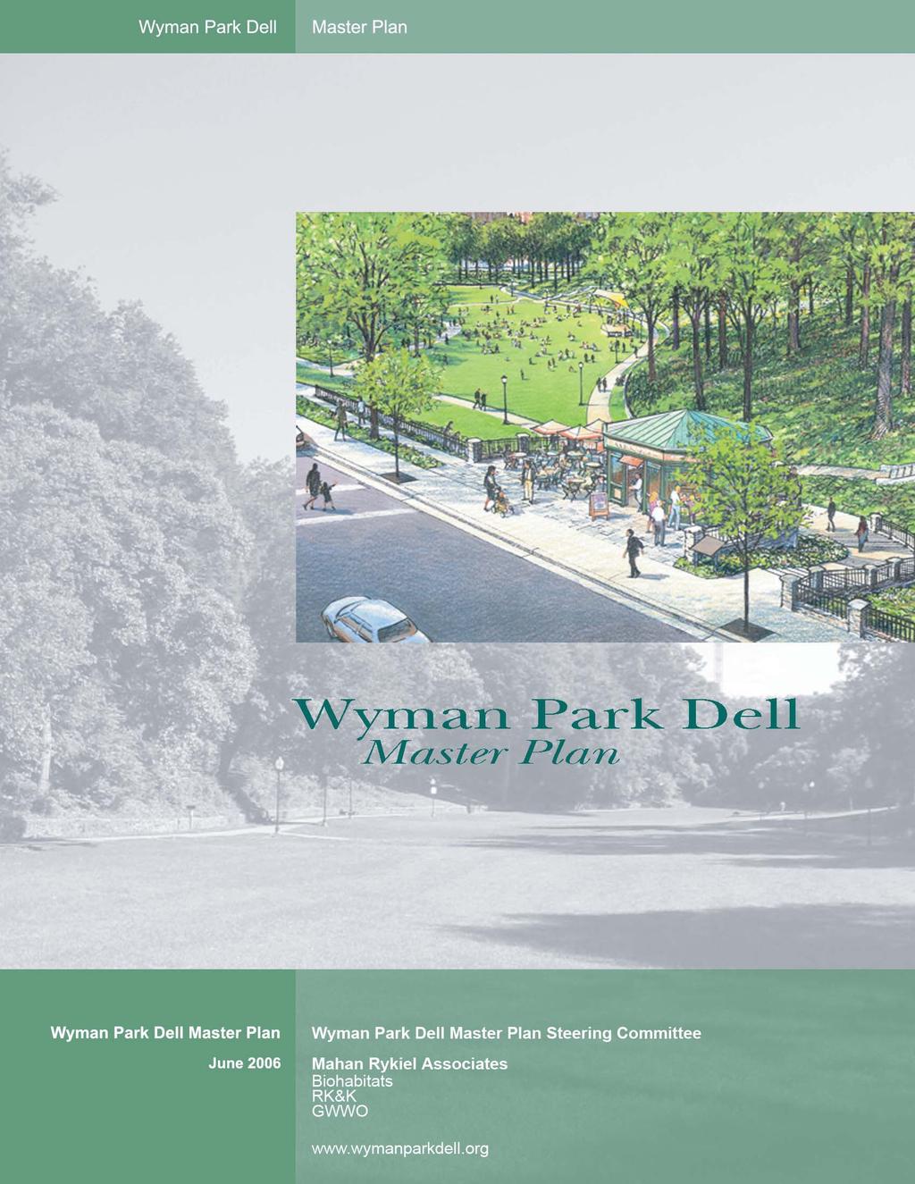
 BALTIMORE MUSEUM OF ART ART MUSEUM DRIVE FRONTAGE D A EE CHARLES STREET FRONTAGE Z E 31st STREET B.")
13 JOHNS-HOPKINS UNIVERSITY (PROPOSED) C LEGEND B EE A. NORTH ENTRANCE, PAVILION & RAMP (Includes Lower Level Restrooms and Storage) BALTIMORE MUSEUM OF ART ART MUSEUM DRIVE FRONTAGE D A EE CHARLES STREET FRONTAGE Z E 31st STREET B. ORNAMENTAL STEEL RAILING WITH STONE PIERS C. WYMAN PARK DELL SIGN D. ART MUSEUM DRIVE NORTH ENTRANCE & PATH E. PARK OVERLOOK H F. HILLSIDE MEADOW G. TEMPORARY STAGE SITE W 31st STREET AA CC BB WYMAN PARK DRIVE WYMAN PARKWAY WEST CRESCENT K L LEE & JACKSON PLATEAU ART MUSEUM DRIVE J H E WOODED SLOPES F I THE LOWER LAWN G DD U S X U V T Y EE W CHARLES STREET RECONSTRUCTION (BY OTHERS) Z Z E 30th STREET H. PROPOSED WOODLAND PATHS/CONNECTION TO PARK OVERLOOK I. RECONSTRUCT STONE WALL J. PROPOSED PATH TO LOWER LAWN K. ART MUSEUM DRIVE REPLACEMENT TREES L. LEE & JACKSON MONUMENT INTERPRETATION & SEATING AREA M. EXPANDED SOUTHWEST ENTRANCE & RAMP N. RECONFIGURED PARKING & ENHANCED PEDESTRIAN CONNECTION (Dependent on Future Study - See Alternate Plan) 0. SEATING AREA & SHADE GARDEN P. PROMENADE WITH BENCHES & GAME TABLES (Staging Area for Festivals) Q. RECLAIMED LAWN (Charles Street Reconstruction) R. PICNIC AREA & EXPANDED PLAYGROUND S. FUTURE PLAY AREA/ACTIVITY EXPANSION T. PROPOSED PATH U. UNION MONUMENT AREA ORNAMENTAL FENCING (42 Height, No Dog Zone) V. REPLACE UNDERSTORY TREES WITH SHADE TREES CC N O M EE P I DD WOODED SLOPES R P U Q UNION MONUMENT PLATEAU W. EXPANDED 30th STREET ENTRANCE X. DOG FREE ZONE (Amphitheater Slope) Y. SELECTED THINNING OF CHARLES STREET EDGE Z. ADDITIONAL CROSSINGS AT 30th/31st STREET (To be explored as part of Charles Street Reconstruction Project) AA. PROPOSED PATHS BB. REMOVE ASPHALT ROAD C WEST GATEWAY C CC. EXPANDED 5-FOOT CONCRETE SIDEWALK DD. MAINTAIN SLEDDING ROUTES E 29th STREET EE. CLEAR VISIBILITY AT ENTRANCES ALTERNATE WEST GATEWAY PLAN: Maintain Existing Road Configuration (Enhanced Pedestrian Crossings) W 29th STREET HOWARD STREET MARYLAND AVENUE N CHARLES STREET Wyman Park Dell Master Plan Exhibit A: Illustrative Master Plan Scale: 1 = North Mahan Rykiel Associates Biohabitats RK&K GWWO June 2006
14 Wyman Park Dell Master Plan Exhibit B: North Entrance Perspective Sketch Mahan Rykiel Associates Biohabitats RK&K GWWO June 2006


 A1 C.")
 B A")
 A E D D C B A E E.")


15 LEGEND: Planting Zones A E A. WOODED SLOPES (Naturalistic Planting for Erosion Control, Wildlife & Buffer) B A E A1.TRANSITIONAL VERTICAL STRUCTURE (Lower-branched Understory for Meadow Foraging Birds) A2. BERRY-BEARING TREES AND SHRUBS (Berry-bearing Plants to Attract Birds) E F A1 A B B. LOW WOODED SLOPES (High Canopy Trees, Low Growing Shrubs and Groundcovers within Important View Corridors) A1 C. WOODLAND EDGE GROUNDCOVER (Naturalistic Groundcovers and Low Shrubs for Slope Stabilization in Shade) B A D. ORNAMENTAL GROUNDCOVER (Low-growing Substitute for Lawn in Areas of Deep Shade) A E D D C B A E E. ORNAMENTAL PLANTINGS (Low, Flowering Shrubs, Groundcover, Seasonal Color and Bulbs at Entrances and around Monuments) A F. HILLSIDE MEADOW (Meadow Grasses and Flowering Shrubs on Hillside) A2 A A B B A2 B A2 E B A E E Wyman Park Dell Master Plan Exhibit C: Planting Zones Diagram Mahan Rykiel Associates Biohabitats RK&K GWWO June 2006
16 PART 2: INTRODUCTION, BACKGROUND AND ASSESSMENT MAHAN RYKIEL ASSOCIATES JUNE 2006
17 I. INTRODUCTION A. Overview Mahan Rykiel Associates was retained by the Wyman Park Dell Master Plan Steering Committee to prepare a long-range master plan for Wyman Park Dell. The Steering Committee is comprised of partners that include Friends of Wyman Park Dell, Baltimore City Department of Recreation and Parks, Baltimore City Department of Planning, Friends of Maryland s Olmsted Parks and Landscapes, Charles Village Civic Association, the Remington Neighborhood Alliance, Johns Hopkins University and the Baltimore Museum of Art. The master plan was made possible by funding by many of these partners, supplemented by grants from the Goldseker Foundation and The Baltimore Community Foundation. The Steering Committee was formed in 2004 through the initiative of the Friends of Wyman Park Dell (FWPD) as long-time stewards of the park. Wyman Park Dell is a 13 acre park located in the Charles Village and Remington neighborhoods of North Baltimore. The Dell is a cornerstone for the entire Wyman Park system and is a vital open space resource for the adjacent communities, institutions and all of Baltimore City. The purpose of the master plan is to provide a tool for FWPD and the City to protect the park and guide park enhancements over the next fifteen years or longer. Because the master plan is far-reaching, this report identifies individual projects that could be implemented incrementally as funds become available and project cheerleaders emerge. While the master plan should be the foundation upon which any improvements are planned, it is not intended that this document be inflexible. As goals and surrounding influences change over the years, modifications to the master plan may also be necessary. It is important, however, to respect the inherent principles and concepts of the master plan. B. Process Identifying the Need: The Friends of Wyman Park Dell has been the steward of the park since the group s inception in 1984 and has been responsible for numerous enhancement projects in the Dell. In 2001, FWPD began exploring the idea of a master plan to better guide its efforts. In 2004, FWPD garnered the support of local partners and established the Wyman Park Dell Master Plan Steering Committee. The Master Plan Steering Committee solicited proposals from four landscape architecture firms in Winter of 2005, interviewed two firms and selected Mahan Rykiel Associates in April The Mahan Rykiel team included RK&K, Biohabitats and GWWO. Park Assessment: The project team began the process by conducting an assessment of the park, visiting it at various times during the day, during the week and during the seasons. In addition to observing how the park is being used, the MAHAN RYKIEL ASSOCIATES JUNE
18 team analyzed it in terms of environmental and physical characteristics including vegetation, habitat, erosion, lighting and park elements (walks, walls, furniture, etc.). Stakeholder Interviews: Concurrent with the park assessment, the project team interviewed a series of stakeholders and leaders within the community. Some of these stakeholders were recognized leaders of official organizations while others were identified as leaders because of their passion and involvement with the Dell and other community issues. A list of stakeholders can be found in Appendix A, Stakeholder List and Input. Town Hall Meeting #1: Following stakeholder interviews and park assessment, the project team conducted a town hall meeting open to the community in September The meeting was held at the Baltimore Museum of Art (BMA) and was advertised on the park website, through community newsletters and on temporary sign panels constructed in two locations in the Dell. The primary intent of this meeting was to introduce the master plan process and to garner input from the community as to concerns, opportunities and expectations. Questionnaire: Following Town Hall Meeting #1, there was a significant amount of interest in having additional opportunities to provide input and to provide an opportunity for those who were unable to attend the September town hall meeting. A questionnaire was developed and made available to the communities and approximately 44 were returned. Town Hall Meeting #2: Based on the assessment and input from the community, the team presented an analysis of the park along with three alternative scenarios for incorporating ideas and presented this in December 2005 at Saints Philip and James Church. Following the presentation, the attendees discussed and evaluated the alternatives and identified preferred elements from each concept. Following the meeting, a few additional ideas, suggestions and concerns were forwarded to the project team via correspondence. Town Hall Meeting #3: Based on input at the second town hall meeting, the team prepared a draft plan which incorporated the preferred elements from each concept and presented it in a third public meeting in March, 2006 at the BMA. Town Hall Meeting #4: Following minor modifications to the draft plan based on comments from the March meeting, the final plan was presented in an open house format in June 2006 at the BMA. Final Report: Following presentation of the final plan, the project team summarized the recommendations of the master plan into this final report. The master plan report will be a tool available for the Steering Committee, FWPD and the Department of Recreation and Parks to implement the master plan. Website: The FWPD website, was used throughout the process to communicate meeting dates, share notes from the Town Hall Meetings, post PowerPoint presentations and post the final plan. MAHAN RYKIEL ASSOCIATES JUNE
19 II. BACKGROUND A. Historic Overview According to the Friends of Maryland s Olmsted Parks and Landscape Archives, the Wyman Park Dell is one part of a larger Wyman Park system and is representative of one of the earliest initiatives associated with the implementation of the 1904 Report Upon the Development of Public Grounds for Greater Baltimore by the Olmsted Brothers. Upon the completion of the report, the development of Wyman Park was already underway as the Wyman Brothers dedicated their estate to public uses. The center of the estate that included Homewood House became the new campus of the Johns Hopkins University; the trustees of the university gave the remainder of the estate to the City as a public park. The largest portion of the park includes the Stony Run stream valley on the west side of the JHU campus, while the other section (now the Wyman Park Dell) included a part of the Sumwalt s Run stream valley on the south side of the JHU campus. The Olmsted Brothers viewed the larger section of Wyman Park as a natural stream valley reservation, with informal pathways (never realized) blending with the landscape. The Dell, on the other hand, was treated as a more manipulated space. This was because of its relatively small size and its location in a rapidly urbanizing section of the City. In addition, because of the extension of adjacent roadways, this section of Sumwalt s Run was an isolated remnant of the original stream valley, no longer connected to the overall stream system. Sewer and storm drain infrastructure also required the stream valley floor to be covered, thus creating the lower lawn area today. The Dell ultimately became a showpiece for Olmsted s signature pastoral park based on a sweeping unobstructed lawn with a strong enclosure that provided a respite from the surrounding urban environment. Over the years, the Dell has remarkably maintained its overall structure and integrity, however some development activity has altered its form. The construction of the BMA and the corresponding raising of Art Museum Drive in the 1920 s truncated the northern entrance to the Dell, creating an awkward relationship with the adjacent streets. However, the Dell matured in the 1930 s with a lower lawn defined by valley walls that were wooded in some areas but nonetheless offered significant views from Charles Street. After many decades, the wooded areas became overgrown in many places and obscured views into the Dell. Thanks to recent efforts of the FWPD, the Department of Recreation and Parks and many volunteers, including those associated with two sequential Jim Rouse Days of Community Service, many improvements have been made related to lighting, cleanup and the addition of features such as a playground and new tree planting. MAHAN RYKIEL ASSOCIATES JUNE

20 Digital Scapes LLC 2006 Olmsted Brothers 1911 Master Plan for Wyman Park, showing the Dell in context with the greater park. Courtesy of Friends of Maryland s Olmsted Parks and Landscapes Archives MAHAN RYKIEL ASSOCIATES JUNE


21 Aerial view of the Dell around, circa Courtesy Friends of Maryland s Olmsted Parks and Landscapes Archives Aerial view of the Dell in the 1970 s. Courtesy Johns Hopkins University Detail showing original pathways. Courtesy Friends of Maryland s Olmsted Parks and Landscapes. MAHAN RYKIEL ASSOCIATES JUNE
22 B. Olmsted Philosophy and Design Principles As a foundation for this master plan, it is important to understand the Olmsted philosophy and design characteristics and how they related to the Dell. Following are some of the fundamental design principles and characteristics: Principles: 1. The landscape can improve the quality of life in a city. 2. Parks should be beneficial and accessible to all citizens of all walks of life. 3. Picturesque and pastoral landscapes should be used to contrast the surrounding harsh city. 4. It is essential to recognize the natural character of the site and respect the spirit of place. Design Characteristics: 1. Use landscape to achieve harmony, tranquility and calmness. 2. Create mystery with deep shadows and the play of light. 3. Achieve a richness of foliage. 4. Establish rolling meadows with scattered shade trees. 5. Align paths to follow the natural contour of the land. 6. Avoid plantings and statuary that draw too much attention to themselves and create distractions. C. Crime Prevention Through Environmental Design The manner in which people use parks is quite different than it was early in the last century when the Wyman Park Dell was established as a park. Today, safety and the perception of safety are very important considerations in whether or not people feel comfortable using a park. The master plan analysis and recommendations, therefore, take into consideration the principles of CPTED or Crime Prevention Through Environmental Design. According to the National Crime Prevention Council, the basis of CPTED is that criminal activity and behavior can be controlled through the design of the physical environment. It includes three primary elements: Territoriality People have an innate desire to protect or defend space which they occupy. This is done by: Improving the appearance of the environment Subdividing large areas into smaller areas that can be claimed Personalizing the environment Creating, maintaining and programing activity areas Designing facilities for various age groups Initiating neighborhood watch programs Establishing beautification programs MAHAN RYKIEL ASSOCIATES JUNE
23 Natural Surveillance For people to take action to defend property or to prevent crime, they must be able to see illegal acts taking place. This is done by: Improving lighting Removing blind spots and visual obstructions Adding windows and front porches to buildings (or taking advantage of views to adjacent windows and porches) Locating vulnerable elements near those which are actively used Training individuals in crime reporting Controling growth of landscape Access Control Access control helps to increase the risks perceived by offenders by restricting their movement and placing them under surveillance. This is done by: Reducing the number of entrances to private areas Fencing-off problem areas Locating vulnerable areas near sources of natural surveillance D. Park Users In developing the master plan, it was important to consider that the most successful parks appeal to a broad variety of people and are, therefore, used throughout the day in all seasons. It is also important to note that there are two types of park users; Destination Users who specifically seek out the park to use and enjoy and Incidental Users who use the park passively while engaged in other activities. The existing user groups for the Dell are identified below. Destination Users Dog owners People seeking relaxation Informal ball and Frisbee games Playground users Monument / history enthusiasts Wildlife / nature enthusiasts Walkers Picnic goers Festival/event attendees Incidental Users Motorists and pedestrians on adjacent streets Pedestrians en route to other destinations via the Dell Visitors on their way from parking spaces adjacent to the Dell to the BMA and its sculpture gardens, JHU, surrounding restaurants and to residents who live near the Dell. Residents and employees who view and enjoy the Dell from surrounding homes and places of employment MAHAN RYKIEL ASSOCIATES JUNE
24 E. Summary of Stakeholder Input The master plan takes into consideration input that was garnered from various stakeholders and community members throughout the process in a series of stakeholder interviews and town hall meetings. This input was also conveyed to community representatives on the Master Plan Steering Committee. Through this process, the design team heard ideas and concerns that ranged from a desire to leave the park as it is, to major changes with lots of new stuff. While there were many common ideas and themes, there were also many opposing ideas such as dogs vs. no dogs. All of the input was carefully considered using discussions with the Master Plan Steering Committee and the design team s professional judgment to create a balance that would appeal to as many stakeholders as possible while maintaining the integrity of the park. A detailed list of participants including the Master Plan Steering Committee, stakeholder interviewees and community participants at the town hall meetings is included in Appendix A, StakeholderList and Input. In addition, notes from the town hall meetings and questionnaires are also included. Below is a summary of the Key Ideas from Town Hall Meeting #1 and the questionaires, listed in order of importance: Town Hall Meeting #1 Assets Overall park design integrity (bowl shape, central open lawn, separation of use areas, original pathway design, oasis in the city ) Biodiversity: diversity of tree species and wildlife Liabilities Dogs off-leash / lack of designated dog area Lack of caretaker or park manager Obstructed views from Charles Street Poor maintenance (general neglect, limited number of trash receptacles) Opportunities Events (movies, flea market, concerts, Shakespeare in the Park ) Water feature or attraction Rebuilding of stone walls Removal of spur road at the northern portion of the West Crescent Threats Lack of historic designation Lack of funding for maintenance Pre-existing plans (traffic circle at Art Museum Drive and Wyman Park Drive, changes to sweep at 29 th Street and Howard Street) Not honoring design integrity and Olmsted legacy MAHAN RYKIEL ASSOCIATES JUNE
25 Questionnaires Key Ideas Maintain integrity of park and qualities as an oasis Improve maintenance Un-leashed dogs are a problem need designated dog area or dog hours Un-leashed dogs are not a problem dog owners are an important user group who activate the park in early mornings and evenings when others aren t in the park Need to address safety Need to provide more opportunities for events Maximize diversity of uses (expand playground, keep sledding, provide interpretation, accommodate seniors, provide picnic opportunities, provide areas for non-dog lovers). Open up some blocked views Improve park management MAHAN RYKIEL ASSOCIATES JUNE
26 III. PARK ASSESSMENT A. General Assessment Thanks to many efforts on the part of the Friends of Wyman Park Dell and the Department of Recreation and Parks, the Dell has improved as a public park dramatically over the past twenty years and offers many assets to the surrounding community and institutions, as well as Baltimore City as a whole. Still, many of the parks greatest assets are also its greatest liabilities. Perhaps this was best described by stakeholder Joe Rexing when he shared, The best thing about the Dell is that it is sunken and enclosed by woods. The worst thing about the Dell is that it is sunken and enclosed by woods. A specific assessment of each area of the park is provided in Part 3 of this report; however, key highlights are described below. The Dell is divided into an upper park and lower park. The upper park relates more to the surrounding community and uses while the lower park functions as an oasis, separated from the surroundings. The overall integrity of the Dell is quite simply defined by the broad sweeping lower lawn and the wooded slopes that enclose the lawn. The gentle curve in the lower lawn provides a sense of mystery and, from some perspectives, gives the impression that the park continues on for a much greater distance than it actually does. The primary entrance into the Dell (Charles Street and Art Museum Drive) is, unfortunately, the least attractive space in the park. In addition, the odors from the sewer, the overgrown vegetation and the placement of transformers make this the least welcoming area of the park. It is also the area where the most dramatic views of the lawn could be had.if they weren t blocked by vegetation. A variety of spaces is found throughout the Dell and accommodates different activities and offers the potential for an even greater amount of activities. The playground for children and the lower lawn area for dog-walkers are the most successful. Because of the Dell s topography, it is rarely used as a cut-through for people using the surrounding streets to get from one destination to another. Visibility to the lower lawn is obscured most of the year because of overgrown vegetation. As a result, many people do not know the Dell exists or feel uncomfortable using the Dell because it is perceived to be unsafe. Much of the park s infrastructure (walls, steps, baths, furniture) is in poor repair. The playground is well-sited and is a good example of how elements can be added to the Dell without detracting from its overall integrity. Tree replacement efforts in recent years have wisely concentrated on oaks, maples and other native species. There are several Japanese Pagoda Trees (Sophora japonica) in the lower lawn area that are not appropriate trees in terms of character and image. Similarly, some understory trees are poorly MAHAN RYKIEL ASSOCIATES JUNE
27 located and contribute to blocking important views. A detailed assessment of trees and other ecological factors is described below. B. Ecological Assessment As part of the park assessment, the design team assessed significant trees, invasive species, habitat and soil erosion. Following is a summary of each assessment. Significant Tree Assessment - Summary The woodland cover in Wyman Park Dell is characterized as a Piedmont/Coastal Plain Mixed Oak-Beech Forest. Typical habitats are dry, usually north-facing bluffs, and steep ravine slopes with acidic, nutrient-poor soils. Plant communities in this group usually contain fewer moisture loving plants and a greater abundance of drought tolerant heaths like blueberry (Vaccinium sp.) and holly (Ilex opaca). Following is a description of ideal reference conditions and the conditions at the Dell: Canopy: The ideal canopy predominantly includes American beech (Fagus grandifolia), white oak (Quercus alba), northern red oak (Quercus rubra) and tulip poplar (Liriodendron tulipifera), most of which are present in the Dell. There are many mature and over-mature beech and white oak that are in diameter at breast height (dbh) showing signs of decline (ie: dead and dying main limbs, discolored leaves, heavy fruiting and/or root suckering). Some younger white oaks have been planted, however, as part of the Joseph Beuys program. Approximately 160 trees in the Dell were loosely assessed in terms of caliper size (trunk size), species and overall health. A tree matrix is provided in Appendix B, Ecological Assessment (Significant Tree Summary). Of the total trees assessed, approximately 10% are in excellent health, 44% in very good health, 24% in good health, 13% in fair condition and 9% in poor condition. Sub-Canopy: The ideal sub-canopy predominantly includes red maple (Acer rubrum) and American holly (Ilex opaca). While a few red maple are present, there are not many, and there do not appear to be any American hollies. There are some areas of ash and beech regeneration and eastern redbud (Cercis canadensis) is present throughout. However, most of the sub-canopy consists of invasive species, described below. Shrub Layer: The ideal shrub layer includes low-bush blueberry (Vaccinium pallidum), maple-leaved viburnum (Viburnum acerifolium), and mountain laurel (Kalmia latifolia). Some of these species are present in the Dell, however, the majority of the shrub layer is comprised of invasive species. Herbaceous Layer: The ideal herbaceous layer includes Christmas fern (Polystichum acrostichoides) and Virginia creeper (Parthenocissus quinquefolia). Again, these are present in limited areas within the Dell. MAHAN RYKIEL ASSOCIATES JUNE
28 With the ideal forest conditions described above, one could expect the following wildlife: Mammals: Eastern chipmunk, gray squirrel, Eastern cottontail, white-footed mouse, woodland vole and red fox. Canopy Nesting Birds: blue jay, Cooper s hawk, broad-winged hawk, Eastern wood-peewee, blue-gray gnatcatcher, Acadian flycatcher, red-eyed vireo and scarlet tanager. Trunk Nesting Birds: great crested flycathcher, Carolina chickadee, tufted titmouse, downey woodpecker, hairy woodpecker, pileated woodpecker, whitebreasted nuthatch and northern yellow-shafted Flicker. Aged Tree Replacement and Forest Plantings Typically, as forest trees age, seedlings from the understory serve as a source of the next generation of overstory trees. The Dell woodland areas have some seedling regeneration but it is mostly comprised of species differing from the overstory. The Del is generally deficient in desirable tree replacements. Planting desirable tree replacements should be a major focus of future efforts. Planting efforts should also focus on creating a transitional vertical structure by providing understory trees in key locations, such as near woodland edges. The lower-branched understory trees provide perching habitats for meadow-foraging birds. Woodland edges should also be enhanced with berry-bearing shrubs to attract birds and denser shrubs should be used on the lower slopes so that visibility to the lawn area from above is not obscured. An approach to aged tree replacement is described in detail in Appendix B, Ecological Assessment (Aged Tree Replacement). Invasive Plant Species Invasive plants are prolific throughout Wyman Park Dell and are primarily located throughout the wooded slopes. Predominant invasive species include the following: bush honeysuckle (Lonicera sp.) English ivy (Hedera helix) white mulberry (Morus alba) paper mulberry (Broussonetia papyrifera) tree-of-heaven (Ailanthus altissima) princess tree (Paulownia tomentosa) privet (Ligustrum sp.) The most significant invasive species are the white mulberry and paper mulberry. The environmental and physical impact of the white mulberry includes the following: MAHAN RYKIEL ASSOCIATES JUNE
29 Displaces native vegetation by forming a monoculture threatening biodiversity and native ecosystem stability. Readily invades disturbed sites, roadsides and fencerows. Negatively impacts wildlife dependent on native vegetation for forage, nesting and cover. Berries litter sidewalks Possibly hybridizing with and transmitting a root disease to the native red mulberry (Morus rubra). The environmental and physical impact of the paper mulberry includes the following: Non-native, exotic plant (from Asia) without natural insects or disease to keep its growth in check Exhibits aggressive growth and quickly invades disturbed lands, displacing native plants. Forms monocultures that threaten local biodiversity and ecosystem stability. Its range is widespread and is found growing from uplands to lowlands. Negatively impacts wildlife dependent on native vegetation for forage, nesting and cover. Shallow root system making them susceptible to blow-over during high winds. While significant volunteer efforts have been made over the past several years to remove invasive species, efforts have not always included a replacement program of native or desirable species. As a result, the sudden exposure to sunlight (by removing invasive species) has provided ideal growing conditions for additional invasive species. An approach to invasive species management is described in Appendix B, Ecological Assessment (Invasive Species Management). Slope Erosion There are several isolated areas of surface erosion associated with steep slopes, compaction and devegetation due to pedestrian traffic. The primary areas include the southeastern corner of the Dell, just to the west of the playground and on the western slope between the upper and lower parks. In many cases, pedestrian traffic occurs along desire lines where paved pathways are absent. A natural solution would be to provide pathways in some of these areas. Erosion also occurs in the vicinity of the Lee and Jackson Monument. While the slopes are fairly gentle here, there is too much shade to establish grass beneath the tree canopy, often resulting in bare soils. Planting shade tolerant groundcovers and shrubs would alleviate this condition. Soil erosion can also be found along walkways and steps that abut steep slopes. Planting native shrubs and groundcover would provide soil-binding roots to help stabilize soils. MAHAN RYKIEL ASSOCIATES JUNE
30 C. Lighting Analysis While it is generally not the policy of the Department of Recreation and Parks to illuminate parks, pedestrian-scaled lighting has been added to the Dell in recent years because it is a small park which had been acting as a location for prostitution, drug use and cover for criminals who committed crimes in the adjacent areas. As part of the master plan effort, the design team observed existing lighting conditions in December, The full memorandum is included in Appendix C, Lighting Analysis and a summary of the conclusions is outlined below. Existing Lighting Conditions Conclusions A field survey of the existing lighting conditions at Wyman Park Dell was conducted on December 7, 2005 beginning at 7:25 PM and ending at 9:00 PM. Light readings were taken at multiple locations throughout the park. Lighting in the vicinity of the intersection of Art Museum Drive and Charles Street is, for the most part, adequate. It is important to note that this area benefits from lighting on the adjacent roadway; if the area were to be redesigned, the impact of the roadway luminaries would not be considered in accordance with IES (Illuminating Engineering Society of North America) recommended practice. Illumination levels for the remainder of the park are below standard recommendations. The western path of the Dell (located near the Lee and Jackson Monument) was not evaluated due to the number of fixtures that were not functional. Overall, an increase in horizontal and vertical illuminance is suggested. As noted in the graphic in Appendix C, there are multiple fixtures in the park that are not functioning. Additionally, some fixtures have cracked globes and there are several types of globes (wide acorn globe and tall/narrow acorn globe). Based on IES recommendations and other project experience, the following lighting is recommended: Average horizontal illuminance ranging between.6 and.8 foot fc (foot candles) with higher levels at the entrances to the Dell. The increased average illuminance will benefit pedestrian safety and encourage increased use of the facility in the evening hours. Uniformity Ratio (average-to-minimum) is not to exceed 5.0:1 to match existing conditions. Vertical Illuminance -.3 fc to.5 fc, depending on community input. It is important to note that the type of optics selected for the luminaire is critical to obtaining sufficient vertical illuminance. Cutoff fixtures (no light above the plane of the luminaire) are dark sky friendly and may minimize perceived glare, however, they are not pedestrian friendly for this type of park setting. With cutoff fixtures, it is difficult to obtain vertical illuminance results greater than 0.1 fc. A luminaire with some MAHAN RYKIEL ASSOCIATES JUNE
31 component of up-lighting, such as the existing pathway luminaries, is desirable. It may also be beneficial to consider the installation of a vandal resistant globe. As improvements are made to the Dell as described in this master plan, these recommendations should be considered on a project by project basis, particularly at park entrances and near steps.. MAHAN RYKIEL ASSOCIATES JUNE
32 PART 3: MASTER PLAN MAHAN RYKIEL ASSOCIATES JUNE 2006
33 IV. MASTER PLAN Based on the stakeholder input and park assessment, the design team prepared three alternative concepts for the park development. Because several areas of the park were appropriate for several different functions or program elements, the alternatives illustrated advantages and disadvantages of locating each of these elements in different areas. The alternatives were reviewed with the community and preferred elements of each plan were selected to be included in the master plan described in this section. A. Guiding Principles There are several guiding principles that helped to define the framework for the master plan: 1. The Dell is part of the larger Wyman Park open space system. 2. The overall design integrity of a well-defined lower lawn bordered by vegetated slopes must be maintained. 3. To be successful, the Dell must accommodate a broad range of activities and feel safe for all ages. 4. Visibility of the park both literally and figuratively must be enhanced. 5. The Dell must be recognized as a valuable city-wide resource in addition to a neighborhood resource. 6. The long term sustainability of the park s habitat and vegetation, particularly its tree canopy, will be ensured throught a tree/vegetation replacement strategy. 7. The park must be managed and protected. Using these principles, the project team prepared three alternatives as described and illustrated in Appendix D, Master Plan Alternatives, to illustrate several different options, each with advantages and disadvantages. The alternatives also illustrated that some desired program element locations remained consistent from one concept to the other, primarily because there is only one logical location for them. Additionally, no alternative could accommodate all of the desired program elements because the park does not yield enough acreage to do this. Consequently, some elements would need to be eliminated or reduced in scope. Based on all of the alternatives, the project team and stakeholders reached consensus on preferred elements from each alternative and recognized that in order to accommodate some preferences, some sacrifices would need to be made. The resulting master plan approach is described on the following pages. B. Master Plan Description While the master plan reflects many changes, the overall structure and organization of the park remains as it currently exists, only enhanced. An MAHAN RYKIEL ASSOCIATES JUNE

34 exception to this is that the Master Plan recommends removing the existing restroom structure which has many problems associated with it. It would be replaced with a new pavilion that would be part of a new park entrance near the intersections of Art Museum Drive, Charles Street and 31 st Street. The entrance would include a more welcoming staircase into the park, along with an accessible ramp for visitors with disabilities. Some of the slope area would be cleared of invasive species and re-planted with low growing native shrubs and overstory trees to open up views into the lawn from this area. The most significant feature would be the pavilion that would serve as a gathering place, a place to get refreshments to enjoy in the park and a facility for park storage, restrooms and a park manager s office. This combination of features would provide much-needed activity and a reason to linger in the park, but more importantly, would address many of the concerns with this corner of the park related to obscured visibility, perceived safety problems and a generally unwelcoming front door as described in the assessment. The master plan is divided into 8 project areas which are identified below and described in detail on the following pages. Because the master plan will be implemented over many years, it is important to identify separate implementation projects, both large and small, that can be implemented individually. It is important, however, to understand how each of these projects relates to other projects within the park so the detail design can respond to the whole. The full master plan is illustrated in Exhibit A, Illustrative Master Plan which is included in the Executive Summary. C. Master Plan Areas Each master plan project area is outlined in the following section in terms of assessment, overall description, design intent, project components, critical considerations and project budget. A detailed construction budget for each project area is included in Appendix E, Project Construction Budgets. The budgets provided are for master planning purposes. Construction and project costs may vary depending on project timing and whether or not projects are constructed individually or grouped together. In addition, a recommended plant palette for each area is described in Appendix F, Master Plant List. MAHAN RYKIEL ASSOCIATES JUNE

35 The Lower Lawn Assesment: Following are the key physical assets and liabilities related to the Lower Lawn area: Assets - Graceful, sweeping form - Illusion of extending beyond the park itself - Pathways and wall alignments accentuate sweeping forms - Strong sense of enclosure and escape - Great place for dogs to run Liabilities - Drain not working properly in one area resulting in stagnate marshy area - Limited visibility to and from surrounding streets, particularly at access points - Barrier-free access only from the east, however, the existing walk is a gradient of 8% and is not ADA compliant - Problems with irresponsible dog owners - Visual clutter transformers, poop bag dispensers - Turf susceptible to extreme wear - Stone wall in poor repair - Sewer smell at northern entrance Design Intent: Preserve the integrity of the original Olmsted Brothers design by restoring the historical park elements without altering the original forms significantly. Avoid filling the space up with additional stuff. Description: The lawn is the signature of the Dell. Its sweeping, open character will be preserved and enhanced. Drainage will be improved and the turf stabilized. A temporary stage site is planned adjacent to the stone wall at the base of the slope in front of the BMA. Here, electrical and water hookups (discreetly located) will be provided to facilitate concerts and performances. The lawn and gentle slope on the east side offer a natural amphitheatre seating area to view performances on a temporary stage. This east slope area will also be designated a dog free zone. Dog owners will be encouraged to walk their dogs on the pathways and lower lawn. The stone wall surrounding much of the lower lawn is in poor repair. It will be reconstructed in the drywall manner to improve drainage control of the slopes. Project Components: Lower Lawn -Preserve the original organic, sweeping form of the lawn. -Improve drainage in wet areas. -Consider closing off portions of the lawn periodically with visually unobtrusive fencing and educational signage to reestablish turf. -Maintain flexibility of open space for different activities, recreation and special events (restrict additional program elements and plantings to lawn edges). MAHAN RYKIEL ASSOCIATES JUNE
36 Natural Hillside Amphitheater -Limb up low branching trees that block views into lower lawn. -Utilize only high-canopied shade trees as replacements such as oak, beech or maple to preserve views to the lower lawn. -Designate this area as a dog free zone by installing signage, as described below. Asphalt Paths and Steps -Preserve the original pathway forms and alignments. -Reconstruct steps that are in disrepair. Stone Retaining Walls -Rebuild the stone retaining walls with dry-stacked stone using granite or other stone that is compatible in design qualities with historic stone walls throughout Wyman Park. -Consider stone wall as a potential memorial project. Temporary Stage Site -Provide the infrastructure (electric and water hookup) necessary to set up a temporary stage at the base of the open slope in front of the BMA. -Relocate the existing green electrical transformer in lawn to a less visible area (woodland slopes). Trees -Gradually remove Japanese Sophora trees and replace with 1-3 specimen quality oaks and or maples. -With exception of accent shade trees described above, keep lower lawn free of tree planting. Site Furnishings and Structures -Replace benches and trash receptacles that are in poor condition, using park standard as described later in this report. -Replace light fixtures that are damaged or not working. -Provide Poop Bag dispensers and locate near edges, trees or other site furniture so as to help reduce the appearance of visual clutter. Dog Area -For the immediate future, rely on self-policing by dog-owners to enforce proper conduct by dogs and dog owners to restrict off-leash dog activity to the lower lawn only and to respect the amphitheater hillside to the east as a dog-free zone. -In the future, if there is increased conflict between dogs and park users reevaluate the policy and consider other actions such as enforcing leash laws, exploring off-leash hours or constructing a separate fenced off dog park tucked into the southern end of the lower lawn. Refurbish Utility Lines (Baltimore City Consent Decree) -Upgrade the existing sewer lines to remove the unpleasant odor near the existing building and north entrance. Coordinate with Department of Public Works to ensure minimal intrusion on existing trees and park features. MAHAN RYKIEL ASSOCIATES JUNE
37 Signage -Provide discrete signage as described later in this report. Critical Considerations: Coordinate with Department of Public Works before making major investment in walls and paths to ensure that upgrades to the sewer will not impact these features. At some point in the future, as the park becomes more successful and draws larger crowds, a turf management strategy will need to be developed. Approximate Budget: Construction $523,300 Design (10%) $ 52,300 Total $575,600 Budget does not include improvements to sewer line nor turf management strategy. MAHAN RYKIEL ASSOCIATES JUNE


38 The Lower Lawn - Images The Lower Lawn is characterized by a strong sense of enclosure and a play of light and shadows and gives the impression that it continues on beyond the actual Dell. Sweeping pathways and the stone wall reinforce the forms of the Dell. The stone wall is one of the most distinct features but is in poor repair. The gentle lawn slope on the east side of the Lower Lawn provides a natural amphitheater and place for picnicking. MAHAN RYKIEL ASSOCIATES JUNE
 of how events could be used to attract people to the")


39 The Lower Lawn - Images Example from Wyman Park (west of JHU) of how events could be used to attract people to the Dell. Example of a dog-free lawn area in New York City. Example of a temporary stage used for Shakespeare in the Park in Greenville, South Carolina. The stage remains for the duration of the festival. MAHAN RYKIEL ASSOCIATES JUNE

40 Wooded Slopes Assessment: Following are the key physical assets and liabilities related to the Wooded Slopes: Assets: - Create enclosure for Lower Lawn - Provide seclusion from surrounding urban environment - Provide opportunities for biodiversity within the park Liabilities: - Erosion problems where cut-through pedestrian traffic occurs - Native forest cover threatened by invasive species - Predominantly mature and over mature canopy - Lacks substantial sub-canopy - Limited sightlines to street, particularly near entrances - Limited pathway connections to Lower Lawn area Design Intent: Selectively open up views at park entrances and other key areas, while maintaining the visual buffer, enclosure and habitats that the Wooded Slopes provide. Project Description: The wooded slopes will be protected and enhanced to increase the biodiversity of the park and to address erosion problems. A few new pathways will be added creating linkages from Art Museum Drive to the lower lawn in areas that are currently acting as cut-throughs and causing some of the erosion problems. One path will be in the approximate location of one originally planned as part of the Olmsted plan. Sledding routes on the east slope near the playground will be protected, but fenced off during non-winter months to encourage the reestablishment of native groundcovers. Invasive plant materials will continue to be removed and replaced with native groundcovers and understory plantings. In some areas, particularly at entrances to the lower lawn, plantings will be restricted to low groundcovers and high canopied trees to allow views into and out of the lower lawn. Refer to Appendix F, Master Plant List and Exhibit C, Planting Zones (included in the Executive Summary). Project Components: Remove and Replace Invasive Plant Species -Remove invasive species (e.g. paper mulberry, honeysuckle, English ivy, privet) that is threatening the native vegetation and replace with appropriate plant material. -Maintain original shade canopy with new plantings. Plant new trees at 3:1 ratio for every invasive tree removed. -Plant an assemblage of tall shrubs and sub-canopy trees along woodland edges (where view corridors are not critical) to soften the forest/meadow edge at the BMA and to create a transitional step habitat. Erosion Control Measures -Plant additional understory and woodland groundcovers to stabilize slopes. MAHAN RYKIEL ASSOCIATES JUNE
41 -Repair broken sidewalks and clogged drain inlets in upper park that result in excess runoff down slopes. -Add additional paths and steps at desire lines.. Selective Thinning at Entrances and Important View Corridors -Selectively remove overgrown and invasive under-story plantings at all park entrances and within important view corridors as indicated on the plan. Replace invasive plants with low- growing native plant materials. -Where view corridors are important, place taller growing shrubs at the base of the slope to allow views from above. Refer to cross section illustration included on the following pages, Wooded Slopes-Images. Proposed Path to Lower Lawn -Provide additional path and steps to lower lawn from Art Museum Drive entrance per the original Olmsted Brothers vision to accommodate desire line and minimize erosion on western slope. Path and steps should be designed in keeping with the character of other steps in the park, however, the low risers that currently characterize the existing steps may not be possible because of the current gradient of the slope that needs to be traversed. Tree Maintenance and Aged Tree Replacement Plan -Limb up low branching shade trees in key view corridors to maintain visibility into park. -Plant replacement shade tree species in areas consisting mostly of mature or over mature trees (e.g. beech, oak). Hillside Meadow at Museum Opening -Convert lawn area to meadow on slope across from BMA. Meadow mix to consist of native grasses and wildflowers that offer seasonal appeal. South West Entrance Improvements and ADA Ramp -Expand southwest entrance into park and provide ADA accessible ramp. Preserve Existing Sledding Routes -Plant low-growing woodland groundcover on eastern slopes where plants are worn away by foot traffic. -Provide fence with gate openings (that can be locked) at top of slope to accommodate wintertime sledding. Allow the groundcover to re-establish in other seasons. -Provide educational signage describing intent of restorative plantings. Critical Considerations: Refer to Appendix B, Ecological Assessment for more detailed information on aged tree replacement and forest plantings. Priority areas within the wooded slopes should be the designated view corridors and entrances. Project Budget: Construction: $334,800 Design (10%): $ 33,500 Total $368,300 MAHAN RYKIEL ASSOCIATES JUNE


42 Wooded Slopes - Images Left: Views to significant neighborhood landmarks, such as the SS. Philip and James dome should be preserved and enhanced. Above: Important view corridors are highlighted above showing where planting should be restricted to low groundcovers and high canopy trees. Right: Restricting taller shrubs to the bottom of the slopse will allow views from Charles street into the Lower Lawn The wooded hillsides provide a strong sense of enclosure for the Lower Lawn. View corridors should be opened near park entrances, however, to improve park image and sense of security for park users. MAHAN RYKIEL ASSOCIATES JUNE

 provides opportunity")


43 Wooded Slopes - Images Native ferns (above) could be used to address erosion (below right). Open hillside (above) provides opportunity for meadow planting (below). Limited pathways along desire lines results in erosion along hillsides. Example of colorful meadow planting on steep hillside in Greenville, South Carolina. MAHAN RYKIEL ASSOCIATES JUNE

44 Union Monument Plateau Assessment: Following are the key physical assets and liabilities related to the Union Monument Plateau: Assets: - Fairly level area at street grade ideal for events - Union Soldiers and Sailors Monument - Attractive and well-sited playground - Potential area for expansion of playground or other active use - Near proposed trolley stop - Additional green space with potential closure of 29 th Street sweep - Highly visible gateway corner at 29 th and Charles Streets - Existing bus stop at 30 th Street - Natural amphitheater space for small events - Park s only barrier-free access to Lower Lawn from this area (however, gradient is 8% and is not ADA compliant. - One of few areas that offers potential for pedestrians as a shortcut through the park Liabilities: - Speeding traffic as long as sweep remains - Gateway triangle area cut off from remainder of park - Ornamental trees block views into Lower Lawn - Park entrance at 30 th Street obscured by vegetation - Lack of electric and water supply for events Design Intent: Take advantage of the Charles Street Reconstruction plan to reclaim the existing asphalt traffic sweep as park open space, and maintain flexibility of this space for special events and gatherings. Create a safe, visually unobtrusive, fenced-in zone around the playground and monument for the expanded playground and future expansion of activity areas. Project Description: This area is located at the southeastern corner of the park. Key features proposed for the future include a broad promenade that can accommodate benches for events such as the Charles Village Festival. The promenade will follow the alignment of the roadway sweep that will be eliminated as part of the Charles Street Reconstruction. In addition, this area will accommodate an expanded playground and other programmed activities. This is one of the few areas in The Dell that can accommodate structures (such as playground equipment) while not detracting from the overall integrity of this Olmsted Brothers park. Special lighting will illuminate the Union Monument at night, and a new pathway will provide better access to the lower lawn. Many understory trees that block views into the lower lawn from this area will be removed and replaced by taller canopy trees. In addition, most of this plateau will be enclosed by a 4 ornamental fence to create a safe and dog-free zone for children and adults alike, much like that in Federal Hill Park. MAHAN RYKIEL ASSOCIATES JUNE
45 Project Components: Union Monument -Provide accent lighting -Limb up existing cherry trees surrounding the monument. Do not replace these trees in the future after they decline. -Utilize CHAP s Adopt-A-Monument Program to secure annual conservation funds for the monument. Ornamental Metal Fencing and Gates -Provide a low 42 ornamental fence with gates around the monument and play area. -Maintain flexibility to open fence and access monument during special events, utilizing several wide gates. -Fencing shall follow inside of path edges. -Fenced area will be designated a Dog Free zone prohibiting both leashed and unleashed dogs. -Provide informally aligned paths and ADA access to playground and future activities. Proposed Path -Provide a more direct connection from the Charles/29 th Street corner to the steps leading to the lower lawn. Picnic Area and Expanded Playground -Provide an informal picnic area with tables and additional shade trees. -Expand playground in each direction along existing pathway. Maintain relationship with woodland edge. -Provide additional shade trees within playground area. Future Play Area/Activity Expansion -Maintain flexibility adjacent to playground and along woodland edge for future activities that may require special equipment or structures. Keeping these elements adjacent to the woodland edge will minimize visual intrusion and visual conflicts with monument. Future activities may include horseshoes, bocci ball or the creation of a labyrinth to name a few examples. Promenade -Maintain the original teardrop form established by the roadway sweeps by widening the existing sidewalk to create a promenade. -Provide special paving (e.g. bluestone) from Charles Street to the southwestern entrance to Lower Lawn. -Use 18-foot width in this zone to accomadate festival booths and other special events. -Provide benches, bike racks and game tables. -Leave cut-outs in the paving of the promenade to accommodate existing trees if necessary. Cut-outs can be filled in with paving at a future date when the trees decline and are removed. -Provide electric and water hookups to accommodate vendors and events. MAHAN RYKIEL ASSOCIATES JUNE
46 Reclaimed Open Space (Charles Street Reconstruction) -Maintain as flexible open lawn area for gathering and special events. Wyman Park Dell Sign -Incorporate park identification sign into low stone wall or ornamental fencing at corner of Charles Street and 29 th Street Transplant Flowering Trees to Woodland Edges -Transplant Kousa dogwoods and other flowering trees that block views to the Lower Lawn to woodland edges. If not feasible to transplant, the majority of these trees should be removed and replaced (in the general vicinity) with larger canopy trees that will not block views. 30 th Street Entrance - Provide park map/directory (possibly near 29 th Street as well) - Provide seasonal color in small space defined by walkways - Potential memorial/monument placeholder in space defined by walkways. Critical Considerations: Removal of the sweep from Charles Street to 29 th Street as part of the Charles Street reconstruction may need to be coordinated with the Department of Transportation. Documentation associated with the Charles Street Reconstruction seems to indicate that the roadway sweep is not public right-of-way, however, this needs to be verified. Park project should try to capture credit for pavement removal if there is increase in pavement with new paths throughout the park (unless credit is claimed as part of Charles Street Reconstruction). Consideration should be given to taking advantage of the proposed trolley stop at 29 th and Charles Streets. JHU owns the Dell House and several properties across 29 th Street from this area. If these properties are renovated or redeveloped in the future, careful consideration should be given to providing ground-floor uses that would relate to and help activate the park. Project Budget: Construction: $664,100 Design (10%): $ 66,400 Total: $730,500 Budget does not include land acquisition costs associated with elimination of the sweep. MAHAN RYKIEL ASSOCIATES JUNE


47 Union Monument Plateau - Images Highly visible gateway potential This is area is at-grade with the surrounding streets, offering potential for park to draw people in There is the opportunity to take advantage of the existing bus stop at 30 th Street, however, the park entrance needs to be more inviting Gentle slope offers natural amphitheater for smaller events. Ornamental trees, though lovely, block important visual connections to the Lower Lawn and should be removed. MAHAN RYKIEL ASSOCIATES JUNE

.")
.")

48 Union Monument Plateau Images Wooded edge provides natural context for integrating structures such as play equipment into the park (above). This is often done in New York City parks (above right). A low ornamental fence could be used to control this entire area as a dog-free zone as in Federal Hill Park (right). With the removal of the sweep, the walkway can be widened into a grand promenade allowing a place for vendors and exhibitors during events. MAHAN RYKIEL ASSOCIATES JUNE
 - Existing parking resource for visitors to the Dell - Tall canopy trees in triangle - Proposed bus stop on 29 th Street - Signal (for crossing) at 29")
49 West Gateway Assessment: Following are the key physical assets and liabilities related to the West Gateway: Assets: - Highly visible west gateway from the Howard Street corridor - Adjacent to Wyman House and an important park user group (seniors) - Existing parking resource for visitors to the Dell - Tall canopy trees in triangle - Proposed bus stop on 29 th Street - Signal (for crossing) at 29 th Street Liabilities: - Existing 29 th Street sweep allows vehicles to speed without stopping - Green triangle area has low sub-canopy trees that block views to Dell and make space uninviting - 29 th Street and sweep act as barriers for seniors and others to get to park - Lacks ADA access to Lower Lawn and entrance steps are dark and unwelcoming - Parked cars create barrier between triangle and Dell Design Intent: Improve the image of the park at Howard and 29 th Streets and strengthen the overall relationship between the triangle and the Dell by creating a usable space within the existing triangle and improving pedestrian access between the triangle and the Dell. Project Description: The southwestern corner of the park will include an enhanced entrance to the lower lawn, with opened sight lines and an accessible ramp to accommodate seniors and those with disabilities. The plan recommends eliminating the broad roadway sweep linking 29 th Street and Howard Street by changing the geometry of the roadway and enhancing the parking area to discourage high speed cut through traffic which creates a barrier between the Dell and the triangle across from Wyman House. This recommendation, however, will need to be studied further with the community, institutions and the Transportation Department. The plan calls for a pronounced pedestrian crossing from the triangle and the parking area and for an enhanced seating area/shade garden. Project Components: Central Gathering/Seating Area -Remove inappropriate sub-canopy trees that block views from the triangle to the Dell. -Provide small paved area with benches. -Establish a placeholder for future monument/memorial within the space. -Incorporate design of gathering space with future bus stop waiting area to improve environment at bus stop. MAHAN RYKIEL ASSOCIATES JUNE
50 Shade Garden -Provide shade-loving ornamental plantings at corner and around gathering space to create an attractive setting for the seating area and to promote a positive image from Howard Street and Remington. -Establish partnership with Wyman House residents who may be interested in planting and maintaining the plants. Strengthen Pedestrian Connection(s) to Park -Use curb extensions and special paving to strengthen pedestrian connections between the triangle and the Dell. Special paving should not utilize any surface that is difficult to walk upon, particularly for seniors. - Replace existing steps leading into the park with re-designed stairs that include a ramp system, providing easier access to the Lower Lawn for seniors and those with disabilities. - Provide park map/directory - Establish potential monument/memorial placeholder at new entrance to Lower Lawn Wyman Park Dell Sign -Incorporate Wyman Park Dell identification sign into a low stone wall or ornamental fencing at corner of 29 th and Howard Streets. Identification sign should match that placed at the corner of Charles and 29 th Streets. Reconfigured Parking (Recommended Option) - Reconfigure sweep so that ingress/egress points are less flowing, removing the ability to speed from 29 th Street to Art Museum Drive without having to slow or stop. - Widen pavement edge by 9-feet in each direction from the existing curb line to accommodate a 58-foot wide parking bay that would allow 90 degree parking on both sides. This would provide the ability to maintain the existing number of parking spaces, while providing traffic calming and increasing green space. Resulting impervious surface is approximately 14,500 SF. - Consider bioretention if configuration results in an increase in paved surface. This option needs to be studied further with the Baltimore City Department of Transportation and the adjacent community. Reconfigured Parking (Option) -Maintain existing 40-foot wide roadway width and parking configuration if recommended option (described above) is not feasible. Resulting impervious surface is approximately 19,235 SF. -Provide curb extensions, special paving and bollards to strengthen pedestrian crossing from triangle into park. - Consider speed humps at the entrance to the sweep to slow motorists as they approach the pedestrian crossing. MAHAN RYKIEL ASSOCIATES JUNE
51 Promenade -Maintain the original teardrop form established by the roadway sweeps by widening the existing sidewalk to create a promenade. -Provide special paving (e.g. bluestone) from West Gateway to Charles Street. -Transition from 18-foot width, further to the east, to 12 width in this zone to accommodate adjacent slopes and parking along roadway sweep. -Provide benches, bike racks and game tables. -Leave cut-outs in the paving of the promenade to accommodate existing trees if necessary. Cut-outs can be filled in with paving at a future date when the trees decline and are removed. -Provide electric and water hookups to accommodate vendors during events. Critical Considerations: It will be difficult to maintain an 18 width for the promenade in this area because of steep slopes and the parking configuration; however, the parking area should be closed off during events to accommodate booths, vendors and activities. If it proves feasible to remove or alter the sweep as recommended, coordination with the Department of Transportation may be necessary and ownership of the actual roadway sweep needs to be verified. Residents of Wyman House should be included in the process for the detail design of the gathering area and shade garden since they are a significant user group for this area. Project Budget: Construction: $203,800 Design (10%): $ 20,400 Total: $224,200 Budget does not include land acquisition if sweep is removed. MAHAN RYKIEL ASSOCIATES JUNE


52 West Gateway - Images 29 th Street, the sweep and sub-canopy trees create physical and visual barriers between Wyman House and the Dell, however, there is great potential to create a gathering area for seniors and draw them into the park. By removing sub-canopy trees, an attractive gathering area such as the one shown above could be established in the triangle area. MAHAN RYKIEL ASSOCIATES JUNE


53 West Gateway Images The existing entrance to the Lower Lawn across from the Wyman House, Senior Apartments is dark, uninviting and offers no ADA access. Regardless of what happens to the sweep, a well-defined pedestrian crossing should be established between the triangle and the Dell. This may be done with special paving (above) or bold crosswalk striping (right). If special paving is used, care should be given to avoiding uneven surfaces that would be difficult for seniors to navigate. MAHAN RYKIEL ASSOCIATES JUNE

54 West Crescent Assessment: Following are the key physical assets and liabilities related to the West Crescent: Assets: - Attractive wooded buffer between residential area and the institutions of Johns Hopkins University and the Baltimore Museum of Art - Mature tree canopy with good visibility through the space - Existing Harris Monument Liabilities: - Few young trees to replace aging canopy in the future - Redundant spur road separates two park spaces - Dangerous intersection at Howard Street /Wyman Park Drive - Narrow sidewalk along east side that is not ADA compliant - Difficult to cross from this space into the Dell Design Intent: Improve pedestrian circulation in this area, while maintaining the passive qualities of this space as a buffer from the surrounding streets. Strengthen the connection between the West Crescent and the Dell. Project Description: This parkland is separated from the main park by Howard Street. Enhancements to this area include widening of the sidewalk along Wyman Park Drive/Howard Street and removal of the spur road at the northern end of the crescent. Additionally, supplemental tree plantings will be provided as replacement canopy for the aging trees. The feasibility of creating a traffic circle at the intersection of Wyman Park Drive/Howard Street and Art Museum Drive to provide safer pedestrian and vehicular movement should be studied in more detail and vetted with the community. Project Components: Expand Concrete Sidewalk -Widen existing concrete walk to 5-foot width, and provide ADA accessible route along Wyman Park Drive and Art Museum Drive edge. Proposed Asphalt Paths -Provide asphalt paths along W. 31 st Street and Wyman Park Drive at existing desire lines. Remove Spur Road -Convert asphalt spur road to open space and replace with path. Aged Tree Replacement -Plant canopy shade trees to replace the aging oaks and other trees. Harris Monument -Utilize CHAP s Adopt-A-Monument Program to secure annual conservation funds for the monument. MAHAN RYKIEL ASSOCIATES JUNE
55 Critical Considerations: Removal of the spur road will need to be coordinated with Baltimore City Department of Transportation. Preliminary studies have been done to explore the option of creating a traffic circle at the intersection of Wyman Park Drive, Art Museum Drive and Howard Street to improve traffic flow and pedestrian safety. This concept is illustrated in Appendix D, Master Plan Alternatives. It is important to note that this idea needs to be explored further with the Department of Transportation and the surrounding community and institutions to fully understand advantages and disadvantages for traffic flow, pedestrian safety as well as the impact on the West Crescent. Project Budget: Construction: $82,700 Design (10%): $ 8,300 Total: $91,000 Budget does not include costs associated with official closing of spur road. MAHAN RYKIEL ASSOCIATES JUNE


56 West Crescent - Images Existing sidewalk along busy roadway is narrow and obstructions inhibit ADA access. Mature canopy provides attractive buffer while allowing important views through the space. MAHAN RYKIEL ASSOCIATES JUNE
57 Lee and Jackson Plateau Assessment: Following are the key physical assets and liabilities related to the Lee and Jackson Plateau: Assets: - Lee and Jackson Monument - Unique grove environment with high-canopied trees - Fairly large area at grade with surrounding streets, inviting pedestrians to cut-through park - Dell has strong presence at terminus of Wyman Park Drive - Joseph Beuys memorial Liabilities: - Monument not ADA accessible - Monument is somewhat lost no interpretation - Erosion around base of monument plinth - Few younger trees to replace aging canopy in the future - Difficult pedestrian access across adjacent streets - Hillside planting creates visual barriers to Lower Lawn - Limited pathway access between this area and Lower Lawn - Loose gravel pathway is difficult to navigate - Difficult to maintain lawn because of shade Design Intent: Increase visibility into the park and utilize the Lee and Jackson Monument area to create more of a destination and gathering space, while creating stronger linkages to the Lower Lawn. Project Description: Similar to the Union Plateau, the Lee and Jackson Monument area could accommodate some additional activities such as horse shoes for the seniors living in Wyman House. The plan also calls for establishing native groundcovers to replace the lawn which is struggling beneath the tree canopies. Supplemental tree planting will provide replacement canopy for many of the maturing trees in this area. Project Components: Lee and Jackson Monument -Provide ADA accessible paths to the lower platform -Provide accent lighting. -Provide interpretive signage between monument and sidewalk. -Create seating area and steps behind monument. -Restore aggregate surfaces in poor condition. -Provide ornamental planting at base of monument to add seasonal color and help stabilize soils. -Utilize CHAP s Adopt-A-Monument Program to secure annual conservation funds for the monument. Asphalt Path -Convert existing gravel path to accessible asphalt path. MAHAN RYKIEL ASSOCIATES JUNE
58 Joseph Beuys Memorial -Provide informal mulch paths to memorial sign and bench. -Replace dead shade tree at memorial. Lighting -Replace and/or repair broken light fixtures. Site Furnishings -Replace benches and trash receptacles that are in poor condition and add additional benches near monument. Planting Zones -Utilize various shade groundcovers to stabilize soil and minimize erosion Woodland Edge Naturalistic groundcovers, low shrubs, ferns and herbaceous material at woodland edge. Transition Zone low, dense groundcover between woodland and lawn (e.g. Liriope). Lawn Lawn in areas of sun and partial shade around monument and at sidewalk edge. - Refer to Appendix F, Master Plant List and Exhibit C, Planting Zones Diagram (included in Executive Summary) Activity Zones -Maintain flexibility for additional low-impact activities such as horseshoes. Critical Considerations: The concept for providing additional paths and access to the monument would impact a few significant trees. Therefore, an interim solution should be considered to provide ADA access to the lower monument platform until such time that the full recommendations can be implemented (when the existing trees are in decline). If interim access is provided, it should be integrated into the overall design of the monument; a wooden ramp or solution that looks temporary should not be utilized. Project Budget: Construction: $203,800 Design (10%): $ 20,400 Total: $224,200 MAHAN RYKIEL ASSOCIATES JUNE


59 Lee and Jackson Plateau - Images Mature trees provide unique grove-like setting but will ultimately need to be replaced by younger trees. Turf is difficult to maintain because of shade and roots. Low groundcovers, such as Liriope, should be considered where it is difficult to establish turf, still allowing a continuous green ground plane such as in this square in Savannah, Georgia. MAHAN RYKIEL ASSOCIATES JUNE


60 Lee and Jackson Plateau - Images The lower plinth to the Lee and Jackson Monument is not ADA accessible, nor is interpretation provided. Bold, simple accent planting and seasonal color should be considered at the base of the monument to highlight it as a special feature in the park, such as with this monument in Savannah, Georgia. MAHAN RYKIEL ASSOCIATES JUNE

61 Art Museum Drive Frontage Assessment: Following are the key physical assets and liabilities related to the Art Museum Drive Frontage: Assets: - BMA plans to reopen main entrance off of Art Museum Drive and facing the Dell - Opportunity to draw visitors from BMA to the Dell and to partner for temporary outdoor exhibits - Dramatic view to Lower Lawn Liabilities: - Speeding traffic along Art Museum Drive - Visitors to BMA are not currently drawn to the Dell Design Intent: Increase visibility into the park along Art Museum Drive and create a stronger visual and physical relationship between the BMA and the Dell. Project Description: The relationship between the BMA and the Dell will be enhanced along Art Museum Drive with the addition of an overlook opposite the original main entrance of the BMA. This will engage more visitors to the museum with the Dell. Direct access will be provided in a series of paths that lead out from this overlook. In addition, the open slope and vista in front of the BMA will be enhanced with native meadow grasses and groundcovers to stabilize the slope. Along the edges of the existing woodland, smaller understory trees will frame the vista and provide a graceful transition between woodland and meadow. Project Components: North Entrance Path and Steps -Selectively thin overgrown vegetation at entrance. -Remove existing lower portion of path along base of wall and pull path and steps away from the retaining wall to provide a more direct connection to the Lower Lawn. -Remove the top portion of the retaining wall (that which projects above the Art Museum Drive sidewalk) with an ornamental railing/stone pier combination to increase visibility to the park from the street. -Provide Wyman Park Dell identification sign on wall or railing at northern corner of park. Park Overlook and Paths -Provide overlook on axis with museum main entrance (as planned in the BMA Master Plan) to capitalize on views into Dell. -Grade overlook to be slightly depressed from sidewalk to allow views over railing from sidewalk. -Consider special paving at overlook area. -Provide seasonal color in planting bed defined by sidewalk and overlook path. -Provide benches and signage at overlook. -Provide park map/directory MAHAN RYKIEL ASSOCIATES JUNE
62 -Provide two crisscrossing paths that lead from the overlook down the hillside to the lower lawn. -Utilize stone (that matches stone used elsewhere in the park) for overlook retaining wall and railing piers. -Consider memorial wall elements along overlook as a naming/funding opportunity (ie: plaques on stone piers). Special Paving and Museum Connection -Provide special paving in broad crosswalk area across Art Museum Drive from planned museum entrance to overlook. -Strengthen the visual connection between the Museum and the park by keeping paved crossing area free of parked cars during events when Art Museum Drive is closed to vehicular traffic. Lee and Jackson Plateau Entrance -Remove tall shrubs near existing steps to Lee and Jackson Plateau area, particularly immediately adjacent to steps. Provide low shrub/groundcover on steep embankment adjacent to steps. Art Museum Drive Streetscape -Replace street trees that are damaged and in decline (red maples). -Enhance woodland edge along Art Museum Drive with replacement canopy trees. Critical Considerations: Coordination with the Department of Transportation will be required to determine feasibility of using special paving in Art Museum Drive across from planned museum entrance and for any impacts within right of way. Project Budget: Construction: $339,600 Design (10%): $ 34,000 Total: $373,600 MAHAN RYKIEL ASSOCIATES JUNE


")

63 Art Museum Drive Frontage Images Dramatic slope and open view provides opportunity to establish stronger relationship between the BMA and the Dell. The master plan proposes an overlook as illustrated above (top) Dynamic views of the Lower Lawn are afforded from Art Museum Drive. MAHAN RYKIEL ASSOCIATES JUNE

64 The overlook should incorporate low stone walls and could be an opportunity to provide sponsorship recognition MAHAN RYKIEL ASSOCIATES JUNE
65 Charles Street Frontage Assessment: Following are the key physical assets and liabilities related to the Charles Street Frontage: Assets: - Adjacencies to Charles Village commercial district and Charles Street - Near Gertrude s Restaurant and BMA sculpture garden - Potential for strong axial relationships with 31 st Street - Charles Street Reconstruction - Views from southbound Charles Street along the length of the Lower Lawn - Existing bus stop Liabilities: - Dark, unwelcoming front door to the Dell - Sewer smell - Overgrown vegetation obscures best views of the Dell and create sense of unease for visitors - Lacks ADA accessibility - 30% Charles Street Reconstruction plans do not provide for pedestrian crossings at 30 th Street - Existing restroom building is unattractive and blocks important vistas into Dell Design Intent: Restore the original design intent of the Olmsted Brothers plan by increasing visibility into park along the Charles Street edge. Relocating the existing north entrance will provide additional amenities (overlook, food pavilion, ADA ramp, storage), while also solving one of the park s largest problems a dark, sunken, unwelcoming major entrance. Project Description: The Charles Street frontage and the intersection of Charles Street and Art Museum Drive are important image areas for the Dell. Planting low native shrubs and groundcovers will allow sweeping views from Charles Street to the Lower Lawn. The plan proposes a major new entrance, opposite 31 st Street, coupled with a new pavilion that provides refreshments and outdoor seating at street level and park operations and restroom facilities on the lower level. Cities worldwide have recognized the importance of the availability of refreshments in a park and their role in encouraging postitive activity. This Charles Street edge of the Dell can accommodate this activity and be economically viable. The pavilion would be within the Charles Street commercial area and could be constructed without destroying the Dell s integrity. Project Components: Charles Street Streetscape -Selectively thin overgrown and invasive understory vegetation along the Charles Street edge. Replace with low-growing appropriate plant material to stabilize slope, while allowing views to the Lower Lawn from Charles Street. MAHAN RYKIEL ASSOCIATES JUNE
66 -Coordinate plantings at park entrances (31 st Street and 30 th Street) with the Charles Street Reconstruction Project. Charles Street trees should be placed to frame not block views into the park at park entrances. North Entrance, Overlook and ADA Ramp -Provide special paving (i.e. bluestone) and ornamental fencing and stone piers (fencing/piers to match that used along Art Museum Drive and at overlook). -Provide tables and movable chairs for gathering, eating, drinking on overlook and lower park terrace. -Provide visitor orientation map/directory. -Construct overlook into hillside to allow for storage, park offices and/or restrooms at the lower level, with ability to construct pavilion or vending carts above. -Relocate existing utility lines in 31 st street to accommodate pavilion and overlook on axis with 31 st Street. -Provide accessible ramp from Charles Street (in vicinity of pavilion and overlook) to Lower Lawn. -Provide electric and water hookup for future permanent pavilion or interim vending carts. -Additional crosswalk added at 31 st Street. -Provide benches, bike racks and trash receptacles -Potential memorial/monument feature incorporated into entrance design. Pavilion -Construct small pavilion for park concessions and information. Architectural design could be traditional or contemporary but, regardless of the style, the building should be of a signature design. -Provide wireless internet connection for park users. Remove Existing Restroom Building -Storage space will be accommodated in new entrance structure/overlook. -Salvage stone for use elsewhere in the park. Expand 30 th Street Entrance -Steps and low stone wall on north side (one side only). -Coordinate with the Charles Street Reconstruction Project to provide additional pedestrian crossings here Critical Considerations: If moving the utilities from 31 st street (to allow the pavilion to be on axis with 31 st Street) is not feasible, the pavilion and overlook should be moved to the south and, if possible, located on axis with the south sidewalk along 31 st Street. Removal of existing restroom building should not occur until new storage facilities are developed with the new overlook. If permanent pavilion is not feasible, the overlook should be designed to accommodate temporary vendor carts as an interim solution until such time that a permanent structure is feasible. The transformers can stay in their existing locations since they will no longer be along the primary entrance into the park. MAHAN RYKIEL ASSOCIATES JUNE
67 There is a trolley stop planned at Charles Street and 32 nd Street, one block to the north of the pavilion area. Information about the Dell should be provided to the Visitors and Convention Bureau to help attract trolley riders to the park. There has been some interest expressed in creating a water feature or other attraction in the Dell. The entrance overlook and pavilion described above would be an appropriate area to incorporate a feature such as this, where sound of water would help mask noise from adjacent traffic. Also, a significant investment such as this should be in a highly visible location where it would be less susceptible to vandalism and also function as a way to attract people into the Dell from the adjacent commercial district. Project Budget: Construction: $1,465,900 Design (10%): $ 146,600 Total: $1,612,500 MAHAN RYKIEL ASSOCIATES JUNE
.")

.")

68 Charles Street Frontage - Images Low wall and overgrowth block most important vista of Lower Lawn (top left). Steps are uninviting and do not provide ADA access (top right). Presence of transformers and old restroom structure along with overgrown vegetation create uncomfortable environment, particularly for the main entrance to the Dell (left). Existing commercial activity should be captured and brought to the edge of the Dell to help activate the park and a new main entrance. MAHAN RYKIEL ASSOCIATES JUNE
 could be lowered to sidewalk elevation and replaced with stone piers and open railing to")

69 Charles Street Frontage - Images The low concrete wall along Art Museum Drive at Charles Street (above) could be lowered to sidewalk elevation and replaced with stone piers and open railing to allow better visibility from the street to the park (below). Restricting taller shrubs to the bottom of the slopes will allow views from Charles Street into the Lower Lawn MAHAN RYKIEL ASSOCIATES JUNE


70 Charles Street Frontage - Images Perspective sketch showing how new pavilion at 31st Street could help activate the Dell and provide a more inviting entrance to the park. Study model illustrates how the lower portion of the pavilion could have additional outdoor seating as well as storage space, restrooms and/or a park manager s office. Existing view from 31st Street illustrates the potential to look down the length of the lawn. Note how vegetation is overgrown. In the summer, this view is completely obstructed. MAHAN RYKIEL ASSOCIATES JUNE


 could be a reasonable interim approach until such")
71 Charles Street Frontage - Images The availability of food, refreshments and portable seating is very important in helping to activate a park.. This example from Greenville, South Carolina illustrates how a terrace area overlooking the Dell might function New pavilions helped transform a dark and unwelcoming entrance into an inviting one in New York s Bryant Park (above). A new pavilion in New York s Madison Square Park is contemporary in design and even incorporates a green roof ( right). Vending carts (above right) could be a reasonable interim approach until such time that a pavilion is funded. MAHAN RYKIEL ASSOCIATES JUNE
72 Other Projects The projects described above are area-specific. Following are additional park enhancement projects that may be included within the project areas described above, or they may occur as a project in and of themselves. These elements generally occur throughout the park and, therefore, consistency in design is critical. In some cases, the elements are identified as optional. Wireless Network: Consideration should be given to providing wireless service throughout the major areas of the park to encourage yet another use and to encourage people to stay in the park. The pavilion area is the most appropriate location as is the Lower Lawn. Signage: A coordinated sign system should be designed for the park including major park identification signs, trailblazers that might be located beyond the park, informational signs, regulatory signs, orientation map and sponsorship recognition. The emphasis should be on a clean simple design and positive educational messages ( The lawn is being restored, please stay on pathways vs. Keep off the grass ). In addition, signage should be visible so that information is conveyed, however, they should be integrated into the setting as much as possible. Visual clutter should be avoided. Interpretation: The Dell has a rich history, yet few know its significance as part of the Olmsted s legacy in Baltimore. Interpretive messages should be integrated into the overall park design to inform citizens and visitors. Interpretative messages should include the Olmsted history, information on environmental restoration efforts and Dell habitats and the Civil War history related to the monuments. Miscellaneous Landscape Planting: While most of the new plant material will be provided as each project is constructed, there may be an opportunity to add new plantings if donors come forward or specific groups want to sponsor new plantings. Following are some basic guidelines for adding new trees and plant materials: All tree and landscape planting should be closely coordinated with the master plan to determine if the construction of future projects will negatively impact the plantings (grading, for example) or if the plantings are part of a broader concept where uniformity of species will be important. The predominant plant material should be large canopy trees that generally have long life spans. The temptation to plant fast growing (and often shortlived) trees such as Bradford pear and cherry trees should be avoided. The most effective park trees are those that get more stately and picturesque with age and those with high canopies that do not obscure sight lines. Appropriate trees include oaks, maple, beech, elm, American sycamore and tulip poplar. The majority of trees should be native to Central Maryland as they are adapted to the soils and climate of this region. Occasional specimens of some non-native but adapted species may also be considered, but only as accents and not widespread plantings. MAHAN RYKIEL ASSOCIATES JUNE
73 Shrub, flower and groundcover plantings should be planted in bold simple masses and should be concentrated in areas where they will make the most impact. These areas include park entrances, edges of gathering spaces, the pavilion area and areas where grass is difficult to maintain. Complex planting beds with only a few of many different plant species should be avoided as they are difficult to maintain and can be visually distracting. Site Furniture: Site furniture primarily includes benches, trash receptacles and bike racks. While some areas of the park may contain a greater amount of site furniture than others, furniture will be located throughout the park and should, therefore, be consistent in design. The bench design should reflect the historic Baltimore Bench and should be adapted to accommodate sponsorship plaques. Trash receptacles and bike racks should be selected to be compatible with the bench in terms of colors and materials and should respect the historic qualities of the Dell. Bike racks should be located primarily near main park entrances such as the Union Monument Plateau, West Gateway and north entrance area along Charles Street. Signage: Like site furniture, signage should belong to a consistent design family throughout the park and should include park identification signs ( Wyman Park Dell ), identification signage for park elements (pavilions, special areas), regulatory signage and sponsorship signage. The signs should be designed to be unique to Wyman Park Dell and may incorporate a special logo or color. Care should be taken not to clutter the park with too much signage or inappropriately located signs. The overall sign system should be designed as a package, then implemented on a project-by project basis. Public Art and Historic Interpretation: Because of the Dell s rich history and proximity to the BMA and its sculpture garden, there is a unique opportunity to capitalize on the park setting and its high visibility for an art in the park program. Public art should be considered for gateway areas and as temporary and permanent features throughout the park. Care should be given to locating public art in context with the overall park landscape design and with sensitivity to the Lower Lawn. Memorial Plantings and Monuments: Parks tend to be logical receiving grounds for memorial plantings. These memorials can be an effective source of income for the park. However, if un-managed they can result in visual clutter that detracts from the overall park and its proper functioning. All memorial plantings shall, therefore, be reviewed carefully prior to planting to determine their appropriateness in the context of the park master plan. It is important to note that, Olmsted generally avoided adding monuments or features that call a lot of attention to themselves. Any memorial or monuments should be carefully designed and located. The Baltimore Park Board has established guidelines and a formal review process for the placement of statues and memorials in city parks. All proposals for memorials must be reviewed by the Park Board and approved by the Department Director. In addition, the Friends of Wyman Park Dell and Master Plan Steering Committee should evaluate proposals prior to submission to the Baltimore Park Board. MAHAN RYKIEL ASSOCIATES JUNE
 as described in this master plan.")
74 The following guidelines should be considered when proposals are reviewed for Wyman Park Dell: Memorial tree plantings should be restricted to areas of the park where tree planting is included as part of a master plan. Care should be taken to avoid planting trees in the middle of an open space (such as the Lower Lawn) as described in this master plan. Memorial tree plantings should utilize species appropriate to the park. Large canopy shade trees are encouraged and could be appropriate in most areas of the park. Sub-canopy trees, on the other hand, should be limited to a few areas as described in the master plan. Nameplates or plaques should be simple and limited to an engraved stone or brick that is set flush with the grade adjacent to the tree. Parking: Approximately 28 parking spaces are provided along the sweep linking 29 th Street with Howard Street (the number of parking spaces in the recommended approach and the option as described in the master plan are the same). While these parking spaces are reserved for the Museum during the day, Monday through Friday, they are available, and should remain so, to the public in evenings and weekends. For the most part, however, parking will occur along existing streets. This is positive as it will provide access to different areas of the park as well as opportunities for more natural surveillance as people enter and exit their cars. It will be important, however, as the Charles Street Reconstruction moves forward, that parking is prohibited opposite 30 th and 31 st Streets where key views into the park should be maintained. Partnerships with surrounding institutions should be explored to accommodate parking for large events, particularly when events do not compete with parking needs of the particular institutions. Parking agreements will need to be coordinated among Recreation and Parks and the surrounding institutions. Diagram illustrates potential placeholders for park directory signs, electric and water hookups, interpretation opportunities and additional monuments/memorials MAHAN RYKIEL ASSOCIATES JUNE


75 MISCELLANEOUS IMAGES Examples of signage that might be appropriate for the Dell. Because the Dell is not well known, trailblazers (top left) might be appropriate to direct visitors to it as it becomes more of an attraction. MAHAN RYKIEL ASSOCIATES JUNE


76 MISCELLANEOUS IMAGES Examples of sponsorship recognition signs. Note that they do not need to be visually dominant. Bench sponsorships such as that used in Central Park (middle) are a great way to generate funds for the park and is something very tangible for people of all income levels. MAHAN RYKIEL ASSOCIATES JUNE


77 MISCELLANEOUS IMAGES Regulatory signs can be much more effective if there is an educational component tied in with the message. This sign from Central Park is an example of one that could be used in Dell areas where invasive species are being removed and replaced with native plants. The availability of wireless internet connections can make the Dell more appealing to a whole new user group. Inexpensive moveable chairs and tables allow users to create the arrangement that fits their current mood alone, with others, in the sun or in the shade. MAHAN RYKIEL ASSOCIATES JUNE
78 V. IMPLEMENTATION PLAN A. Project Priorities Implementation of the master plan will occur over many years on a project-byproject basis as described in this report. Project priorities will vary depending on available funding and the efforts of project champions the key stakeholders most interested in implementing a particular project. However, some early priorities should be considered, as successful completion of these will help to change perceptions of the park, increase the number of park stakeholders, help maintain momentum for future improvement projects and help build credibility for all of the park support groups, as outlined in Appendix G: Park Support Groups. Critical first steps should focus on physical elements such as park edges and elements that will help change perceptions about the park, defining ways to improve park management, establishing replacement trees for the mature canopy areas, removal of invasive species and promotion of the park and the master plan. Priorities to consider include the following: 1. Begin planting program to secure future of large, canopy trees. Plant initial new canopy trees made available through the Department of Recreation and Parks in Spring, Place order in Fall, 2006 for additional trees. 2. Develop an invasive plant management strategy. Continue removal of invasive plant materials, concentrating on key view corridors and at entrances to the Lower Lawn. Efforts should focus on removal of invasive species and replacement with natives. 3. Stabilize eroding slopes with plantings. Protect with temporary fencing and educational signage that explains restoration effort. Complete efforts in specific areas one at a time, starting with key view corridors and at entrances. 4. Provide drain for wet area in Lower Lawn. Provide inlet and connect to existing storm drain system to eliminate mosquito hazards and unattractive overgrowth. 5. Repair walks and steps with temporary or permanent treatment, depending on context within master plan. Initial efforts should focus on the worst conditions, such as dangerous steps. 6. Repair stone wall. This is a three-phase effort. First it will be important to prepare design drawings, then seek funding (or sponsorship) then construct the wall. 7. Widen existing sidewalk along West Crescent. Walking along Wyman Park Drive as it transitions into Howard Street is uncomfortable for pedestrians because of speeding traffic. The sidewalk should be widened early on to accommodate those with disabilities, area residents and those who will be visiting/going to the new South Quad at the JHU campus. MAHAN RYKIEL ASSOCIATES JUNE
79 8. Design and construct gathering area/shade garden in West Gateway area. The seniors in Wyman House are an important user group for the Dell. 9. Design and fence the Union Monument Plateau area. Establishing the kid and family-friendly zone at the Union Plateau will send a highly visible message that the Dell continues to be enhanced and made a better resource for the surrounding communities. 10. Develop comprehensive sign system. System should include schedule of messages, potential locations and design template. While new signs are not an immediate priority, it will be important to establish the design of the sign system and typical messages so that as new projects are implemented, the correct signs can be installed at that time, in association with the project. 11. Develop bench, tree and garden sponsorship program and corresponding fund-raising campaign. As with the sign system, the details of a sponsorship program should be established so that as projects are implemented, these sponsorship elements can be incorporated directly into the project. Include options ranging from individual elements (like a singular tree or bench) to groves or entire garden areas (such as the Joseph Beuys Memorial). 12. Formalize organization of Steering Committee partnerships. The master plan is complete, but it will be important for partners to continue working together to get the message out, to establish capital campaigns and to oversee the master plan implementation. 13. Participate each year in Baltimore City C.I.P. planning process. Purpose is to get Dell projects included in the fiscal year budget. 14. Work with Baltimore City Planning Department to ensure that Dell is protected as a park. Initially, apply the new Open Space Overlay District zoning classification which is currently being developed. Begin to explore Landmark designation for Wyman Park Dell. 15. Develop events program. Begin to develop series of events to activate and promote the park. Events should be highly visible and some should be developed with some regularity such as a First Friday Movie Night which allows people to get used to coming to the park a particular night of the week or month. 16. Celebrate each success. Promotion and visibility of the Dell is extremely important. The completion of each new project, no matter how small, should be publicized and celebrated to continue to change perceptions of the park and to recognize (and energize) those who have worked so hard to implement the project. Events and celebrations could be something as simple as a cookout or something themed to fit the project, such as a circuit walk along the pathways, to highlight the completion of a new pathway system. 17. Become active in CHAP s Adopt-A-Monument Program. FWPD should become active in this program to secure annual conservation funds for the Lee and Jackson, Union Soldiers and Sailors and Harris Monuments. MAHAN RYKIEL ASSOCIATES JUNE
80 B. Design Documents While some of the improvement projects outlined in this master plan are relatively straightforward and require little additional design, many projects will require detail design and the development of construction documents. Some of these design projects may be initiated by the City s Department of Recreation and Parks and others may be initiated by Friends of Wyman Park Dell or the Master Plan Steering Committee. Design documents are critical to the successful implementation of the master plan and should be prepared prior to the construction of any major project, whether it involves infrastructure (like parking and stormwater drains), built elements (like walks, pavilions, or walls), or planting (like Lee and Jackson Plateau planting or the Wooded Slopes invasive removal and re-vegetation). C. Park Management Through the new Office of Partnerships, work with Friends of Wyman Park Dell (FWPD) to formalize a working relationship between the two organizations and improve park management. One of the first tasks that should be considered is assisting FWPD with exploring the feasibility of a paid staff position, responsible for park management. The position could oversee the park, address maintenance concerns, coordinate volunteers and coordinate the implementation of the master plan in accordance to the vision. Following is a sample of responsibilities that might be included in a position such as this: Typical Responsibilities Assist in developing and implementing park programming, including special events, visitor services, concessions, development and enforcement of park rules and regulations. Facilitate development of and maintain public/private partnership programs such as conservancy boards. Assist in developing a long-term strategy for implementing the master plan. Assist in identifying the necessary resources for implementation of the master plan including funding, staffing, expertise and systems. Assist in developing and implementing short and long-term funding strategies for the park, including initiatives that include the private sector. Assist in developing and implementing a short and long-term promotion and marketing strategy to increase community, corporate and foundation interest in the park. Develop and maintain volunteer program and network. MAHAN RYKIEL ASSOCIATES JUNE
81 Develop and implement an on-going management study to improve the quality of park maintenance and operations. Develop and implement a natural resource management plan identifying the responsibilities of in-house staff as well as the needs for outside consultants or additional technical staff. Develop and implement park programming and special events strategy, coordinating with Charles Village and Remington community groups; Baltimore Museum of Art and Johns Hopkins University and other organizations as appropriate. Assist in designing and implementing a visitor services strategy. Design and implement a strategy for effective enforcement of park rules, including the use of park rangers and coordination with BMA and JHU security personnel. Develop a comprehensive concessions policy and a plan for attracting responsible investors and sponsors. Review proposals (such as community service projects, tree donations, etc.) generated by the public and stakeholders and determine appropriateness based on master plan. Schedule and coordinate the use of the park grounds and facilities. Coordinate with City permits office regarding permits for park use. Program special events and promote public utilization of park resources. MAHAN RYKIEL ASSOCIATES JUNE
82 PART 4: APPENDICES MAHAN RYKIEL ASSOCIATES JUNE 2006
83 APPENDICES Appendix A Appendix B Appendix C Appendix D Appendix E Appendix F Appendix G Stakeholder List and Input Ecological Assessment Existing Lighting Analysis Master Plan Alternatives Project Construction Budgets Master Plant List Park Support Groups MAHAN RYKIEL ASSOCIATES JUNE 2006
84 APPENDIX A: STAKEHOLDER LIST AND INPUT MAHAN RYKIEL ASSOCIATES JUNE 19, 2006
85 APPENDIX A: STAKEHOLDER LIST AND INPUT MASTER PLAN STEERING COMMITTEE Marcia Holden, Chair, Friends of Wyman Park Dell Sarah Fawcett-Lee, Friends of Wyman Park Dell Sandy Sparks, Friends of Maryland s Olmsted Parks and Landscapes Emily Thayer, Remington Neighborhood Alliance John Spurrier, Charles Village Civic Association Alan Dirican, Baltimore Museum of Art Mark Demshak, Johns Hopkins University Mary Porter, Baltimore City Department of Recreation and Parks Tamara Woods, Baltimore City Department of Planning Eric Holcomb, Baltimore City Department of Planning STAKEHOLDER LEADERSHIP PARTICIPANTS Business Community John Shields, Gertrude s Restaurant Faith and Senior Centers Alice Jellema, Church of the Guardian Angel Regina Smith, Wyman House Friends of Wyman Park Dell Suzanne Rexing Institutional Leaders Doreen Bolger, Baltimore Museum of Art Dr. Jim McGill, Johns Hopkins University Larry Kilduff, Johns Hopkins University Real Estate Agents Judy Morris, Long & Foster Security Steve Ossmus, Johns Hopkins University Ron Haddaway, Baltimore Museum of Art Doug Gibson, Baltimore City Police Charles Village Festival Joe Rexing, Charles Village Festival (UMBC Campus Architect) Community Leaders Beth Bullamore, Charles Village Civic Association MAHAN RYKIEL ASSOCIATES JUNE
86 Institutional Grounds Managers Brad Pudner, Baltimore Museum of Art Baltimore City Department of Recreation and Parks Fran Spero Sharon Shuler Friends of Maryland s Olmsted Parks and Landscapes David Holden Baltimore City Department of Planning Duncan Stuart Gary Letteron, Environmental Planner TOWN HALL MEETING PARTICIPANTS The following names were taken from the sign-in sheets from each Town Hall Meeting. By signing in, the participants did not necessarily indicate support or opposition to the ideas discussed. Town Hall Meeting #1 Ed Hopkins Joan Floyd Lucy Cook Mark McMullen Phyllis J. Lindley JoAnn Orlinsky Julisa Slavikas Christie Richards Darlene Harenberg Mark Counselman Susie Counselman Dave Bobart Wendi Groden-Thomas Cathy Brilhart Suzanne Rexing David W. Wallace Kwabena Appiah N. Yarlery Kent Waters Sara McCarty Emily Thayer Carole Evitts Joe Slattery Tim Msozek Emily Ellickson-Brown Maria Matveena Christina Ralls Sandy Sparks David R. Holden Daniel Jones Mark Demshak Dottie Campbell Kevin Koenig Dan Bailey Terry Broar Alan Dirican Jim Morrison Chuck Bullamore John Rouse Tim Armbruster Helen Kerig Christine Gardella Regina Smith Chris Bruce Aaron Oldenburg John Spurrier Betty Hill Peter Cramer Tiffany James Mark Derien Al Barry Pam Kelly Mary Porter Tamara Woods Jodie Shivery Phyllis Jaslow Sheila L Rees Sarah Fawcett-Lee MAHAN RYKIEL ASSOCIATES JUNE
87 Town Hall Meeting #2 Valerie McGuire Mary Porter Betty Hill Mariann Millard Jeff Millard Emily Thayer Kathy Poole Martin Kramer David Holden Marcia Holden Beth Bullamore Chuck Bullamore John Spurrier Brad Erickson Jennifer Erickson Sarah Fawcett-Lee Jason Lee Sandy Sparks Sandy Waters Kevin Koenig Town Hall Meeting #3 Martin Kramer Richard Fawcett James L. Jeweers Kent Waters Wink Hastings Regina P. Smith John Orlinsky Fred Besche Chuck Bullamore Tim Hartman Kevin Estis Larry Kildruff Sheila L. Rees Terry Brown Victoria Der Judith Manterah Mark Counselman Joan Floyd Mike O Keefe Steve Theodowpoulos Lucy Cook Judith Orlinksy Alan Dirican Betty Hill Bryen Fracchia David Holden John Shields James D. Thornton Tim Armbruster Douglas Armstrong Chue Romano Julia Romano Brad N. Erickson Mary Porter Valerie McGuire Ron Griffin Gerry Kirk Nicholas M. Prevas Tamara Woods Sarah Fawcett-Lee Mr. William Saxon Mrs. William Saxon Jason Lee Julie Cook Salem Reiner Beth Bullamore Patricia Canick Cherlyn Kirk Mark Derien John Spurrier MAHAN RYKIEL ASSOCIATES JUNE
88 STAKEHOLDER INPUT Town Hall Meeting #1 September 13, 2005 The following comments represent input generated by meeting participants. At the conclusion of the meeting, participants were asked to place dots adjacent to the ideas/issues that they felt were most important. Assets 1 Park is a selling point. 2 Unique bowl shape illusion. Quiet place in the city. (2 dots) 3 Keep integrity/diversity of trees (1 dot). 23 species of birds. (2 dots) 4 Keep and enhance native, non-invasive trees. (2 dots) 5 Park feels old/established. 6 Keep trees that screen Dell illusion of country. (A-1) End of Page 1 Old stone keep/enhance. 2 Separation separate playground from lawn. New use shouldn t destroy integrity. (1 dot) 3 Statues are unique: one North/one South. 4 Pathways keep true to original design (3 dots). 5 Maintain wildlife diversity. (A-2) End of Page 1 Gentle natural amphitheater doesn t require formalization. (2 dots) 2 Variety of spaces/shapes/forms. 3 Sledding places. (1 dot) 4 Preserve playground enhance. 5 Antique style light posts. 6 Understated, elegant space not overly programmed. (A-3) End of Page 1 Relative safety of the Dell. 2 Welcomes everybody. 3 The history/providence pedigree. (2 dots) (A-4) End of Page 1 Preserve as buffer from urban conditions. (2 dots) 2 Variety of views. Keep lawn open (Feels larger than it is). (3 dots) 3 Terrific gathering place -- edges & below. (1 dot) 4 Continue to attract diversity of user groups. (B-1) End of Page 1 Gentle natural amphitheatre an asset. 2 Preserve sledding routes in winter (along Charles Street & down BMA slope). 3 Preserve defined areas for activity (active along Charles, quiet along Art Museum Drive). 4 Preserve wetland area at bottom of steps for biodiversity. (4 dots) 5 Community s interest in the Dell. MAHAN RYKIEL ASSOCIATES JUNE
89 6 Dog friendly. (2 dots) (B-2) End of Page Liabilities 1 No staff /caretaker. (4 dots) 2 Attracts homeless, drug addicts hustlers (not as bad as before). 3 Paths not handicap accessible (1 dot). 4 Benches too low. 5 Low swampy area attracts insects, unattractive. 6 Charles Street edge is sketchy. Planting obstructs views from Charles Street. (3 dots) (A-5) End of Page 1 Triangles are neglected. (1 dot) 2 Poe Statue moved and others moved. Some spaces might not have a purpose. 3 Sewer line under Dell? 4 Condition of stair entrances and asphalt paths (should be stone or gravel/brick). 5 Inability to/ lack of planning for sustainability. (1 dot) 6 People don t know it is there. (1 dot) (A-6) End of Page 1 Entrances not visible/clear. 2 Lack of amenities for possible use (no electric, water, restroom). (1 dot) 3 Building is a liability creates a dark corner. 4 Lighting creates high contrast areas. 5 Lights on Art Museum Drive too close to eye level. (2 dots) 6 Hard to get City to adjust timing of lights for different seasons. (A-7) End of Page 1 Neglect of park itself; not maintained (invasive species, trees limbed up, stairs redone). (1 dot) 2 Severe erosion. (movement along desire lines). 3 Swamp area at base of steps unattractive & attracts insects. 4 Dogs (off leash) and irresponsible owners. (1 dot) 5 Lack of designated dog run. (5 dots) (B-3) End of Page 1 Stench of raw sewage. (from both utilities & people). Sewer line under Dell? (1 dot) 2 Safety/uncertainty due to enclosure and lack of visibility. 3 Trash pickup inconsistent & limited number of receptacles. (2 dots) 4 Overgrowth difficult to see in/out safety (Art Museum Drive & Charles Street).(1 dot) 5 Edges scruffy & unattractive to passerbys. (2 dots) (B-4) End of Page 1 No coordination between residents' planting & Dell maintenance. (No system to locate areas where residents can plant). MAHAN RYKIEL ASSOCIATES JUNE
90 2 Security within the Dell lacking. (2 dots) 3 Graffiti on benches & structures unattractive. (B-5) End of Page Opportunities 1 Possible dog hours. 2 Creation of native meadow areas. (1 dot) 3 Removal of Spur street at Western Edge. (3 dots) 4 Put a stream/waterfall to dump into a pond needs something to draw people in. (5 dots) 5 Add water/power source to accommodate events. 6 Wireless networks. (1 dot) 7 Tables for checkers/chess. (A-8) End of Page 1 Living classroom/take advantage of native environment. (1 dot) 2 Drinking fountain. (2 dots) 3 Capitalize on history w/signage and interpretation. 4 Rebuild stone walls as dry stone walls help erosion. (4 dots) 5 Community notice board. 6 Acquire a caretaker. (1 dot) 7 Large enclosed NY style dog run. (A-9) End of Page 1 Design for low maintenance. 2 Triangle at Howard and 29 th Valuable space next to senior center sitting area for seniors. (2 dots) 3 Events, but not as money makers make available to all. 4 Utilize portable power sources. 5 Connect Dell to sculpture garden/bma take advantage of this relationship. (2 dots) 6 Opportunities for art and functional art. (A-10) End of Page 1 Movies in park during summer. (3 dots) 2 Community flea markets/concerts/shakespeare. (2 dots) 3 Events as revenue generators. 4 Activities to draw people in. (chess tables, etc.) 5 Pavilion could serve coffee & food (e.g. Starbucks?). (2 dots) 6 Enhance playground (climbing structure). (B-6) End of Page 1 Flower beds (possibly below museum on hillside). 2 Temporary ice skating rink. (1.5 dots) 3 Picnic tables draw families. (1 dot) 4 Research/model after Central Park rehab (signage and grand entrances). 5 Flexible seating rent a deck chair (make your own space). (2 dots) 6 Explore public/private partnerships. (B-7) End of Page MAHAN RYKIEL ASSOCIATES JUNE
91 1 Events that highlight local community. 2 Enhance sledding slopes/routes. (1.5 dots) (B-8) End of Page Threats 1 Events that are too large and attracting too many people for the Dell to handle. 2 Complacency/neglect. 3 Poor maintenance of surrounding streets leads to erosion. 4 Dell doesn t have its own identity (officially) within the Greater Wyman Park. (1 dot) 5 Lack of promotion (awareness for Dell within community). 6 Traffic impedes connections to park. (A-11) End of Page 1 Invasive species and labor intensiveness of removing. 2 Potential not to honor historic legacy. 3 Pre-existing plans that threaten park. (4 dots) 4 Appearance of apathy. (A-12) End of Page 1 Future tall buildings could cut off light to Dell. (2 dots) 2 Threat of development in Dell. 3 Lack of sustainability of maintenance. 4 BMA/JHU expansion or encroachment into Dell a concern. 5 Land might not be legally protected as historic designation. (10 dots) 6 City lacks well-funded parks/recreation department for maintenance. (4 dots) City is the ultimate custodian. The park is too large for a community group to maintain. (B-9) End of Page 1 Invasive plant materials & ability to control. 2 Historic Olmsted legacy will not be honored. (3 dots) 3 Will City actually implement master plan? Where will the money come from? (2 dots) (B-10) End of Page QUESTIONAIRE RESPONSES 8/05/05-10/31/05 Strengths - It is a wonderful urban park. Please maintain it as it was designed. - Trees both old and new. Walkways. Accessibility. Overall attractiveness. - Below grade park area helps to buffer City traffic noise. - Public usage occurs despite minimal City maintenance and investment. MAHAN RYKIEL ASSOCIATES JUNE
92 - The way the park is split into sections naturally should be maintained. It allows a relatively small park to serve many different interests simultaneously. - Toboggan runs, walkways & steps, enhance entrances & improve visibility & sight lines/add more playground equipment. - It is away from the City because it is sunken and surrounded by thick vegetation. - Landscape area for dogs, football & benches. - Open, yet feels protected by the trees, that is able to be used by the community. - Wooded slopes and open central area. Need more flowering trees & shrubs. I would like to see butterfly bushes. - The Dell is a great place to take dogs because they can run around w/o being too close to the street. It is also a good place to exercise and/or relax. - Open space; allowance for dogs. - The Dell ought to be preserved as a Green Space for Public Use. - Nicely landscaped; should preserve and enhance cleanliness maintain lamps; maybe maintained more frequently would be helpful. - To stay clean. - One of the great strengths of the current Dell is the large number of dog walkers who frequent it. While at certain times of day after work, for instance it can get almost crowded with dogs playing around and chasing each other, that is a very small price to pay for the other effect that such use provides: safety. My understanding is that in the past, the Dell was not always the safest place. I m sure it isn t still. But, it is now frequented at nearly all times of day by friendly, conscientious (as in they clean up after their dogs) dog owners, and their presence is the best deterrent to crime I can imagine. I m sure that there will be people pushing to limit the access of dogs to the Dell, or to start enforcing leash laws there. I believe this would be a terrible mistake; if owners can t let their dogs run free in the Dell, they will stop coming. The current situation is a remarkable example of self-policing. Unless it changes in some marked way, I strongly urge any plan that is developed not to meddle with the dogs. - The Dell is our oasis in the middle of a busy city. Its strengths lie in the fact that it has many uses, from playground, dog park, ball field. These should be preserved. - The peaceful atmosphere. The lush trees and plants that surround the park. The open areas for the dogs to play. - The basic design is fabulous it really provides respite from the city environment. We should continue to pursue the Olmsted landscaping, but we must take care not to destroy small animal and bird habitat. - Large known for games, protected from traffic by hillsides with trees; 2 beautiful monuments, large trees, benches in shade. - I love the way the Dell is now; it is unusual because it is like being in a valley. - Its open, green spaces its shape pleasing to be in. This is what should be preserved. - Open space for dogs & people to meet up. Lots of trees. Good walking path. MAHAN RYKIEL ASSOCIATES JUNE
93 - The Dell serves as one of the rare, open-air locales where residents can exercise, walk their pets, and have picnics. - The open green spaces are key to community building plenty of trees a feeling of space in the middle of the city with grass. - Robert Lee statue. Can it be illuminated with vandal proof lights? Cover head lights attached to trees). - The circulation system of pathways - The lovely expanse of green the meandering paths and established shape of park are very soothing to walk on. Not to stray from original design. Weaknesses - No conservation program for statues. - While doing cleanups, I have noticed that the city provided trash receptacles are plastic barrels, which migrate around the park. In addition, there are not enough of them. The side of the park nearest to 29 th street has none. The trees need to be pruned properly! We cannot expect to keep the grand, old trees unless they are properly cared for. - Dogs. The Dell is known as a dog park. I have talked to several people who do not use the Dell solely because of the dogs. Some people are intimidated by the large number of dogs running freely and illegally while some are deterred by the dog feces. (There will always be some percentage of the dog owners who are negligent in this area). - Security. The other common reason for not using the Dell is security concerns. - Trash, poor maintenance, swamp area at bottom of steps (a river runs through this area Stoney Run and it is blocked by the Senior Citizen Center on 29 th Street. - Use by homeless persons as bathroom, bedroom, & storage area for bedding. General poor upkeep no regular watering; too few trash receptacles. Bad smell (sewer gas?) at the north end. - Places should be designated for specific activities so that many people can utilize the park at the same time. Also, more lights & landscaping that deter crime are always beneficial. - Maintenance of walkways, steps, sweeping. Lighting is adequate, but fixtures are prone to vandalism. Difficult to cross Charles Street to get to and from the park. - The swamp! It s ugly and unfortunately a fun spot for dogs. Plant a tree or something. Drainage. In rainy days, the puddles just get bigger and don t go away. Sewage smell. Coming from the area circled on the map. - Haven t been there at night, but lighting? Perhaps water fountain for dogs and people. - Marsh-like area in the SW area. People still sleep on the benches at night. Although well lit, no policing. The old lavatories building something should be done with that. - Marshy area, which does not drain. Park benches need work. Need more trash cans. Sewage smell. MAHAN RYKIEL ASSOCIATES JUNE
94 - The northern corner sometimes smells bad and has human excrement. Also, the trees and bushes should be a little better maintained. It could be a little cleaner. - I think more grass in the bottom main area would be nice. I would also like a small gate/fence at the tops to prevent children and animals from getting hit by cars. - Missing understory on BMA slope. Missing understory on Charles Street slope. Blindingly bright lights, causes one to stumble on stairs (can t see). - Too many dogs off leash especially pit bulls; it should not be only a dog park. - I don t see any real problems or weaknesses with the Dell. - The worst problem is trash! Sometimes the inability to sustain it. This year, we have done wonderful things, tree plantings, shrubs, but it must be maintained. - The sewer smell; the swamp area (turn into a wildflower garden). - We must pay full-time staff to maintain and protect the Dell. Then rest rooms could be responded. The stone wall must be restored. - Need a pedestrian bridge to connect over Howard Street see photo repair comfort station get grant for Dell caretaker to monitor and keep clean. Dogs illegally running loose. - Dogs are a problem when the owner thinks the Dell belongs to them instead of the public; dog poop problems too. - Keeping it clean and in good repair; especially the stone wall & steps. Benches too. - It s a little bit stinky near Art Museum Drive because of the sewers (I guess). It s not well lit at night; kind of creepy. - A stronger, more visible police presence, on bicycles, cycling through, would be great and take care of the swampy areas! - No running water drinking fountains. Redo stone retaining walls. - Badly deteriorated paths and stone walls, stairways. - Playground surface should be replaced and no longer chips. The benches need new and better slats. Need water fountain with dog fountain. - Poor trash maintenance. People trash/litter. Vandalism of existing fixtures; ex. trash bins, dog bag holders, benches, lamp posts. Noncompliance of poop and scoop. Opportunities - New space from triangle could be used for new features: playground expansion, vendors. - The City Recreation Bureau (I think) has a city park band that plays in parks across the city. We could do a night with the Park Band and publicize it. (Like Bolton Hill does in Fitzgerald Park). - We have the opportunity to put up a couple of historical markers at entrances to the park. They could identify it as an Olmsted designed park and talk about its history. Not just a sign that says Wyman Park Dell. - I would suggest that there is an opportunity to provide aesthetically pleasing receptacles, which would be anchored into the ground, preferably near each series of benches. The receptacles could look like MAHAN RYKIEL ASSOCIATES JUNE
95 wrought iron strips with a receptacle inside. I think I have seen these on the Hopkins University campus. - But is seems that we could work towards making the park more people friendly right now. The entrances to the Dell are labeled with signs about keeping your dog on a leash and, I think, about cleaning up after your dog. Can we you start getting this law enforced? Periodic sweeps through the park, resulting in fines for a bunch of people could go a long way towards getting the dogs their owners really under control. And if we get the dogs under control, and let people know about it, we might be able to get some of the dog-adverse people back into the Dell. Can we get the Hopkins or Charles Village Security people to go down INTO the Dell? There are students down there now doing things, despite the dogs, and it would be in Hopkins interest to extend its security down there. I think it would be great if the Hopkins security people on bikes started looping down into the Dell. (They don t have to carry their bikes down steps they can come down the sloping path from the south east corner where the playground is). And can we do anything to get more lighting in the Dell? Dottie and I go out walking after dark, but we would never dream of going down into the Dell. We go up on Hopkins campus where there are lights, security people and other people all around. Improve the security, curb the dogs, and let the community know about it. Why wait? - One more philosophical note about the issues raised at the Master Planning meeting the other night. There are two radically different schools of thought about the future of the Dell: one has it as a rural wilderness sheltered from the hustle and bustle of the city; the other has it as full of life, drawing the life of the city into itself. I, the guy who suggested the Starbucks in the Dell, subscribe to the Full of Life point of view. The only possible future for the Dell as a living park and not as an abandoned wooded area like the woods behind the Zoo in Druid Hill Park is to find ways to bring the people in and get the fullness of life going all the time. That life of many people in the park draws more people and creates security. My ideas are not at all original with me. I subscribe to the view of Jane Jacobs, in her great book on cities: The Death and Life of Great American Cities. I have considered giving a course on this book at the Free University and might yet do it). - A full-time maintenance person; a positive use for the little stone building. - Possibility of creating a fenced-in section for dog exercisers. - Existing trodden paths in wooded areas could become walking trails, if cleaned up and enhanced. - The Dell should be the center of the community providing a place for organized community activities. It would be great to have a committee for the park for each interest that planned events. - Sumualt Run consider unburying this stream and restore it through the Dell as a water feature. - Whatever is done, capital needs to be in place for continued upkeep. Right now, upkeep is minimal and usage has increased exponentially over the last couple of years. - More community activities; concerts? - I think more people would come to and enjoy the Dell if there were more benches and if the benches were in better condition. MAHAN RYKIEL ASSOCIATES JUNE
96 - This space could be used. Ice rink? Stadium? Hopkins athletic field? Hmmmm.. - More patrolling at night. - I don t see any missed opportunities, really. It s not a big enough area for organized sports, but it s fine for the occasional pickup game of touch football, or Frisbee. - Concerts, community picnics, more playground equipment. - Avoid false opportunities. - Dogs must be leashed or contained within fenced area as now, they interfere with human s use of the park. - More activities for children in the near neighborhoods & concerts too. Arts, running, biking for the kids w/the help of the Hopkins students. - I wouldn t want to spoil the Dell, but an art show and sale on an annual basis would be a great way to attract attention or perhaps an afternoon concert series of classical or jazz, once in a while. - Cleaner landscaping and safe passageways at night. - The field would be an excellent place for concerts and could be utilized more during festivals. - A gazebo, if maintained, would be an attraction for music and social events. - Introduction of a stage for performances/programs. The stage design should be unobtrusive and integrated into the cleared space, path to the BMA, utilizing the grassy slope as a natural amphitheater. Threats - Taken over by eminent domain (Jay Brodie supports it, the Supreme Court supports it) BMA tried to take part of the park in the past. - Aforementioned problems could intensify and make the park so unpleasant, it will fall into disease. - Parents with children need a protective separation from the dog running so that the parents can relax and feel their kids are not threatened. - Would be great to have an area where dogs can run freely, with places for owners to sit & talk, and with appropriate sanitary trash collection. - Different people wanting to use the same space for different activities i.e. an area should be made separate for children to play, separate dog area, picnic area and sports area. Efforts should be made with design to ensure that everyone who enjoys the Dell for different activities is able to continue their use without feeling threatened or inconvenienced by other activities. I think using the parks natural borders and adding some fencing for areas such as the dog area, is the best way to accomplish this, but another alternative is to assign certain times for specific activities (i.e. off leash dog hours from 6:00 AM 9\8:00 AM and again from 4:30 PM 6:30 PM). - Vandalism of playground, benches. - Cutting down too many trees. They provide shade from the sun, shelter from the rain, and privacy from the noisy city. - Lack of upkeep. It took years for the park to become what it is now. Doing some hair-brained scheme that meets the needs of a vocal minority. MAHAN RYKIEL ASSOCIATES JUNE
97 - After nearly two (2) decades of not utilizing the park Dell, my family now goes there daily enjoys the company of others. I am afraid that too much change (the rest cut off) - As a dog owner, too many people not picking up after their dogs. - Leash laws could negatively impact the Dell because a lot of people bring their dogs there. It is the only place in the area where dogs can be off the leash and run. - Creating unnecessary rules or making the Dell unusable due to statues, more trees in the main area, or not allowing dogs. - Over-management. Car exhaust. Erosion. Developers. Drunken students. Dog waste. - Kids out there at night (Johns Hopkins students). Prostitution and homeless. - The biggest threat to the Dell would be an attempt to control the dog activity there. - Lack of interest; lack of ownership of the Dell, not keeping it natural and welcoming. - We must guard against too many uses. The Dell is after all, quite small. Too small for team sports or a separate dog area or any other separate areas. We must avoid attempting to subdivide our wonderful but limited space. Parking developers always lust after any open space. They are often clever and always relentless. They must be watched carefully. This especially applies to the flat areas off Charles Street and Art Museum Drive. - Encroachment to benefit traffic or parking. Inability for children to run and play games on large lawn because of loose dogs. - Development. - Not maintaining it would be a threat. Any encroachment as in adding structures also a threat.although some sculpture or rock/natural formation could be a treat. - Overbuilding in that area don t want it to turn into a parking lot or shrink in size. - Development projects would destroy the Dell by rebuilding it as commercial property, a parking lot, etc. - JHU s steadily encroaching through Charles Village save the green spaces for our community! - Changing traffic pattern to remove southern service road. Parking would be lost and access to JHU from Charles Street would be hindered. - Changes that are not in character w/the simplicity/subtleness of the original design. - Could Charles Village safety guards fine litterers? More frequent trash pick-up. - Support the proposal of a person in attendance (9/13) that legislation be enacted that Wyman Park Dell be permanently protected as a park. Large parts of Wyman Park have already been given to JHU (along San Martin Drive). - Having lived in this area since 1969, I remember when the city assigned a caretaker to the Park who was very conscientious, kept out those who misused it, kept the steps clean and cleared and performed basic upkeep. A treasure like W.P. ought to be cared for in this way. With such a MAHAN RYKIEL ASSOCIATES JUNE
98 person present, it might be possible to maintain a sanitary restroom, which will add to the park s assets. - Would be great to maximize the creation of flexible, multi-purpose space. - Need an all-weather bulletin board for public information & notices. - Multi-purpose space should be adaptable for musical and theatrical performances. - Need a monthly general maintenance strategy plan to guide the City and supportive organizations. - Consider making the grassy hillside a dog-free zone where people can picnic or sunbathe without sitting in dog excrement. The Dell functions well as a defensible refuge. Survey should ask about usage of park by respondent, and include a respondent profile. Should include a preamble to explain how the survey will be used. - Water fountain in marshy area to take advantage of underground spring? - I don t know what that small building on the north side is for, but maybe it could be put to better use. - Why not plant wetland-type plants in wet areas? And for future dog waste composting pit maintained by volunteers.. - I could not live here without this park. I am in it every day! It has always been a haven for me. - Add more trees, lights & flowers/garden.no development. - I love the Dell because it s a green oasis that welcomes pets and their people. Dogs need to run and people need the fresh air and friendly socialization that the Dell facilitates. - Somehow keep the Park dog friendly. Dogs are vital to the people in Charles Village. Can the CV benefits district patrol cars ride thru at night to discourage vandalism? - Redo the perimeter sidewalks as a 10 foot path directly abutting the streets except by the Jackson and Lee sculpture where space is too limited. Use a surface that is softer and friendly for walkers. - Steps could be improved maintained. TOWN HALL MEETING #2 December 15, 2005 Discussion related to alternatives as described and illustrated in Appendix D, Master Plan Alternatives. Following presentation of the alternative concepts, the following ideas were discussed by those present: General: Discussion about where funding will come from to implement plan. Funding will depend upon partnerships. Detail discussion about this will occur at draft stage (Town Hall Meeting #3) Town Hall Meeting #3 will occur in February (date to be determined). Signage should be well-placed and designed in a visually unobtrusive manner. MAHAN RYKIEL ASSOCIATES JUNE
99 West Crescent: Existing sidewalk along Wyman Park Drive/Howard Street is narrow and dangerous. Like all concepts that widen and improve this sidewalk. Potential gathering space at north end of crescent (Concept C) is pointless and not necessary, particularly when considering that Hopkins is building a new entrance across the street. This will be the gathering area. Concern with traffic circle and the impact that it would have on the crescent (by taking land area from the crescent). Like idea of improving pedestrian crossings but could traffic circle be smaller? What is the smallest size circle possible? Historic photo of Dell (in snow) appeared to show some sort of circular movement. Concern that traffic circle would detract from integrity of the Y intersection that currently exists. After much discussion on the traffic circle, the suggestion was made that further study, including traffic studies, and vetting within the community would need to occur on this issue. The final report should, in an appendix, show ideas that have been explored. First priority is pedestrian safety expanding existing walkway. Like sidewalk connection down lower part of crescent. Recognition that people will cross from Crescent mid-block along Howard Street but that this should not be a marked crosswalk to encourage that behavior. Show closing of spur road as an option. The plan is not dependent on this and this idea should be vetted further within the Remington community. Art Museum Drive Edge: No particular discussion Lee and Jackson Grove: No particular discussion 29 th Street Edge: Need to provide electric and water hookup along this edge to accommodate events such as Charles Village Festival. Like the idea of a 15 (approximately) promenade (Concept B) rather than a large paved plaza (Concept C). The wide promenade would accommodate events but not appear empty when events are not taking place. Is there a bike path connection to Jones Falls trail? Need to look at traffic impacts of eliminating sweep at 29 th and Howard Street. All three concepts show elimination of this road, however, it should not be assumed that this is a done deal. Discussion clarified that this was an incorrect assumption on Mahan Rykiel s part. This will need further study outside the master plan, however, the master plan is not dependent on this going away. Traffic studies and more conversation within the Remington community will be needed on this issue. If roadway sweep does go away at 29 th and Howard, Concepts B and C are preferred over Concept A as they allow access from both Howard and 29 th Street. Union Plateau: Suggestion from the community to create a fenced area for people in this zone, similar to Federal Hill Park where no dogs (leashed or unleashed) are allowed within the fenced zone. This idea garnered a lot of discussion. An ornamental fence should be used and it should cover a large enough area that it doesn t feel like a pen. Seating, picnic and playground areas could be MAHAN RYKIEL ASSOCIATES JUNE
100 located within fenced area. Fence would only need to be about 4 high. It should not be a visual barrier. A suggestion was made to locate the fence adjacent to walkways so that it has a logical context within the park. Mahan Rykiel will explore the concept of a separate fenced area for the draft plan. Charles Street Edge: No specific discussion. The Lawn: Suggestion that a pavilion should be considered in lower lawn at southern end of park to play off of pavilion at northern end. Nobody seemed to like the idea of a small fenced dog park as shown in Concept B. There would be significant smells associated with this and it disrupts the integrity of the lawn area. Most favored off-leash times vs. a separate dog park (ie: Prospect Park in Brooklyn, NY, however this is a much larger park may not work here). Some remarked that many dog owners would not observe hours. Many agreed that the dog owners are, for the most part, self-policing and preferred the recommendations of Concept A. It was suggested that these ideas can be discussed in the master plan, but it can be dealt with separately from the master plan. Perhaps dog owners could work with City in experimenting with different solutions. Discussion on dog park led to discussion on separate fenced people area (see discussion under Union Plateau). Wooded Slopes: Idea of new path connections down into the lower park was well-received. Transition Slope: No specific discussion other than that this area should be dog free because it is a great place to sit and picnic. North Gateway: Creating a pavilion with food availability, terraces add interest (see Millenium Park in Chicago). Food in parks is key to attracting users and it would be feasible here because of its proximity to nearby retail and attractions (museum, sculpture garden, etc). Concept B is preferred over Concept C as pavilion at 31 st Street has better interface with Charles Village commercial district and it does not impact any Beech Trees (as would Concept C). Concern that a restaurant would require significant parking. Discussion clarified that this would not be a full service restaurant rather a pavilion with limited refreshments, serving people already using the park and in the area. It was also mentioned by a citizen that the Charles Street Reconstruction plans accommodate additional parking. Restrooms must also be provided. Discussion clarified that restrooms, park management office, storage would need to be included in any kind of structure. Concept A could be a short-term alternative leading up to Concept B. At any rate, Concept A should also incorporate an ADA ramp connection from Charles Street down to lawn. MAHAN RYKIEL ASSOCIATES JUNE
101 TOWN HALL MEETING #3 March 23, 2006 General Discussion Like the examples of signs that had positive messages vs. Keep off the Grass Plan does good job of balancing different needs while maintaining integrity of park Important that crossing at 29 th Street sweep or parking area (at West Gateway) not have a rough surface so it is easy for seniors to cross Plan is appalling because removal of sweep at 29 th Street and widening of parking area reduces size of triangle Don t put new footpaths along the length of the West Crescent.not needed just improve existing sidewalk along outer edge. Need detailed list of plants, emphasize native plants Stone wall should use granite because it is common to the area Need to give more information related to temporary stage area and how this is to function Like the pavilion idea Concern with pavilion what would Olmsted think of this? If pavilion goes in, is there the danger of building more and more commercial establishments around the perimeter? Need to protect as park space. MAHAN RYKIEL ASSOCIATES JUNE
102 APPENDIX B: ECOLOGICAL ASSESSMENT MAHAN RYKIEL ASSOCIATES JUNE 2006
103 APPENDIX B: ECOLOGICAL ASSESSMENT I. ECOLOGICAL GOALS a. Improve & maintain native vegetation community health through the removal and monitoring of invasive plants. b. Improve & maintain nesting, foraging and over-wintering habitat for various types of bird communities. c. Increase biological diversity through incorporating additional plant species and habitat types. II. ECOLOGICAL NARRATIVE a. Existing Conditions i. Native Vegetation 1. There are many mature and over-mature beech (Fagus grandifolia) and white oak (Quercus alba) that are in diameter at breast height (dbh) showing signs of decline (ie. Dead and dying main limbs, discolored leaves, heavy fruiting, root suckering). Most of the understory is composed of invasive species but there are some areas of ash and beech regeneration. ii. Soils 1. There are isolated areas of surface erosion associated with steep slopes, compaction and de-vegetation due to pedestrian traffic. The main areas include: south-eastern corner to the west of the playground, western slope between upper bench and lower bench. Other areas of surface erosion exposing tree roots occur in either steep sloping areas with little ground vegetation or heavily mowed areas that are shaded. iii. Invasives 1. Invasive plants are prolific in Wyman Park Dell. Those species most commonly occurring include: bush honeysuckle (Lonicera sp.), English ivy (Hedera helix), white mulberry (Morus alba), paper mulberry (Broussonetia papyrifera), Tree-of-Heaven (Ailanthus altissima), Princess tree (Paulownia tomentosa), and privet (Ligustrum sp.). b. Reference Conditions i. Piedmont / Coastal Plain Mixed Oak Beech Forest Communities in this group are similar to Mesic Mixed Hardwood Forests but usually occupy drier, steeper sites that support fewer mesophytic plants and a greater abundance of heaths. Typical habitats are drier, usually north-facing bluffs, and steep ravine slopes with acidic, nutrient-poor soils. 1. Canopy: American beech (Fagus grandifolia), white oak (Quercus alba), northern red oak (Quercus rubra), and tulip poplar (Liriodendron tulipifera) 2. Sub-canopy: Red maple (Acer rubrum), and American holly (Ilex opaca var. opaca) MAHAN RYKIEL ASSOCIATES JUNE
104 3. Shrub: Low-bush blueberry (Vaccinium pallidum), mapleleaved viburnum (Viburnum acerifolium), and mountain-laurel (Kalmia latifolia) 4. Herbaceous: Christmas fern (Polystichum acrostichoides) and Virginia creeper (Parthenocissus quinquefolia). Few other herbaceous species occur. 5. Mammals: Eastern chipmunk, gray squirrel, Eastern cottontail, white-footed mouse, woodland vole, and red fox 6. Canopy Nesting Birds: blue jay, Cooper s hawk, broad-winged hawk, Eastern wood-peewee, blue-gray gnatcatcher, Acadian flycatcher, red-eyed vireo, and scarlet tanager 7. Trunk Nesting Birds: great crested flycatcher, Carolina chickadee, tufted titmouse, downey woodpecker, hairy woodpecker, pileated woodpecker, white-breasted nuthatch, Northern "yellow-shafted" flicker 8. Ground Nesting Birds: whip-poor-will, black-and-white warbler, ovenbird c. Summary Several steps to meet the goals listed above: 1. Remove and manage the invasive plant species threatening the native vegetation. 2. Plant an assemblage of tall shrubs and mid-story trees to soften the forest/meadow edge at the BMA Overlook and produce a transitional step habitat. 3. Maintain views and increase vertical structure by planting low growing native plants at the base of the hill slopes. 4. Prevent erosion of soil by planting shade tolerant native ground cover plants in select areas. 5. Enhance bird habitat by planting native fruit bearing shrubs in select locations. III. AGED TREE REPLACEMENT & FOREST PLANTINGS Typically as forest trees age, seedlings from the understory serve a source of the next generation of overstory trees. The Wyman Park Dell woodland areas have some seedling regeneration, mostly comprised of species differing from the overstory, but are generally deficient in desirable tree replacements. Conduct a thorough health and hazard assessment of the mature trees. a. Aged Tree Status: Each of the actively managed woodland areas should receive a complete inventory to assist in the development of a long-term tree replacement plan. Through this inventory the significant tree resources can be identified, mapped and evaluated. Evaluations of health condition can then be used to determine the urgency of replacement by individual tree. i. Inventory significant trees 1. Mature and over-mature trees of the Wyman Park Dell woodland area occur regularly throughout the site. An assessment of the health of individual trees should be conducted to determine the health status of each tree 18 or greater. MAHAN RYKIEL ASSOCIATES JUNE
105 ii. Determine health condition and risk status 1. Many mature oaks and beech are showing signs of stress and decline. In the spring, look at the top of the oaks for dead limbs and sparse branching. Decline seems to be related to an imbalance of crown/root ratio. A reduction in the number of branches lessens the demand on the roots for water. Thinning of the crown and removing the dead branches is the most direct way of helping an oak in decline. (This is not topping a tree). Mulching and fertilizing may also invigorate a tree. A stressed tree with dead branches is an invitation to diseases and insect invasions. 2. Hazard Trees- Hazardous defects are visible signs that the tree is failing. We recognize seven main types of tree defects: dead wood, cracks, weak branch unions, decay, cankers, root problems, and poor tree architecture. A tree with defects is not hazardous, however, unless some portion of it is within striking distance of a target. b. Tree Removal & Improvement: As part of a long term tree replacement strategy and to improve the overall health of the Wyman Park Dell tree removal and/or trimming should be incorporated. i. Prioritize removal based on risk and health 1. Objective criteria for tree removal include: current and future maintenance costs, years of estimated useful life, structural integrity, and public welfare. Because they are more subjective, the following items should be considered only as secondary criteria: diminishing aesthetics, amenities, and engineering values, such as noise abatement and wind reduction. 2. Removal recommendations must clearly identify priorities for tree removal. These priorities could become a sequence for removal. Dead or dying trees might be first. Second would be trees representing a potential hazard to adjacent property, buildings, parked cars or people. Next might be stumps from trees cut previously. The final category could be trees growing in undesirable locations. ii. Arrange for possible use/disposal of removed tree resource 1. Citilog 2. Local composting/mulching facility c. Planting Plan: A planting plan should be developed and incorporated into the management and operations of the park. First priority for planting should be currently non-forested aged-tree removal areas. Second priority for planting should be forested areas in need of supplemental vegetation and replacement of invasive plants. Include as part of a planting plan: i. Species, Sizes & Quantities ii. Planting locations iii. Planting procedures iv. Tree removal procedures v. Integrated Vegetation Management (IVM) MAHAN RYKIEL ASSOCIATES JUNE
106 d. Summary i. Conduct a mature tree inventory & health assessment. ii. Perform decadent and hazard tree removal and trimming prioritization. iii. Develop a planting plan and IVM plan. IV. INVASIVE SPECIES MANAGEMENT There are several steps included in an invasive species management plan. First, identify and map key areas of invasive infestation. Second, apply treatments specific to the target plant species. Third, regularly monitor the treatment areas to assess the effectiveness of the treatment. Lastly, re-apply the treatment to areas identified through monitoring. The number of reapplications will vary by the site, but may be multiple years. a. Invasive Species Treatment Example i. Bush honeysuckle (Lonicera maackii, L. tatarica, L. standishii, L. morrowii, L. xylostem, L. X. bella, and possibly others) 1. The recommended approach for honeysuckle control is treatment with a systemic herbicide followed by physical removal or retreatment with herbicide the following spring. a. Foliar Herbicide Treatment Foliar application to shrubs using GLYPHOSATE, surfactant and a colorant should be considered for large thickets of bush honeysuckle where risk to non-target species is minimal. This treatment is recommended in the fall. b. Cut Stump Treatment This control method should be considered when treating individual bushes or where the presence of desirable species precludes foliar application. This treatment is effective as long as the ground is not frozen. This treatment should take place in fall or early spring when native vegetation is dormant. c. Basal Bark Method This method is effective throughout the year as long as the ground is not frozen for mature shrubs with a diameter at breast height (dbh) of 6 inches or less, providing no desirable native species are growing around the base of the target shrub. d. Physical Control Because hand removal of bush honeysuckle is time consuming and in some instances promotes resprouting from any left over plant material or seed bank, this method is appropriate only for small initial populations or environmentally sensitive areas where herbicides cannot be used. V. COSTS a. Invasive Species Management costs can vary greatly depending on the target species and their density. Although many of the species at Wyman Park Dell have been identified, the degree of infestation needs to be calculated as part of an invasive species management plan. Estimated cost $4,000-8,000/ Acre MAHAN RYKIEL ASSOCIATES JUNE
107 b. Planting cost for understory enhancement in forested areas varies according to the final palette of plant species and size. Estimated cost $8,000-12,000/ Acre VI. ADDITIONAL ITEMS Some other specifics associated with developing both the aged-tree replacement strategy and invasive species management plan involve planning for resource allocation and incorporating an adaptive management framework. Resources include labor requirements and material costs. An adaptive management framework includes developing targets, trajectories, monitoring, and modifications when needed. MAHAN RYKIEL ASSOCIATES JUNE
108 SIGNIFICANT TREE INVENTORY Biohabitats September 2005 Tree ID # Common Name Scientific Name DBH (in) Health Note Action 1 Beech Fagus grandifolia 36 Fair Severe limb damage 2 Elm Ulmus species 15 Excellent 3 Beech Fagus grandifolia 40 Good Limb up 4 Beech Fagus grandifolia 29 Good Limb up 5 Tulip poplar Liriodendron tulipifera 29 Very Good 6 Beech Fagus grandifolia 48 Good 7 Beech Fagus grandifolia 28 Poor Severe limb damage 8 Tulip poplar Liriodendron tulipifera 54 Good 9 Beech Fagus grandifolia 39 Very Good 10 Beech Fagus grandifolia 36 Excellent Limb up 11 Beech Fagus grandifolia 29 Very Good 12 Beech Fagus grandifolia 38 Very Good Exposed roots Limb up 13 Beech Fagus grandifolia 38 Very Good Limb up 14 Beech Fagus grandifolia 32 Excellent 15 Sugar maple Acer sacharum 16 Excellent 16 Sugar maple Acer sacharum 15 Excellent 17 Mulberry Morus species 19 Very Good Significant lean Remove 18 Beech Fagus grandifolia Very Good Exposed roots 19 Black cherry Prunus serotina 14 Good 20 Tulip poplar Liriodendron tulipifera 36 Excellent 21 Hackberry Celtis occidentalis 20 Poor Severe limb damage/trunk damage/exposed roots Remove 22 Beech Fagus grandifolia 30 Very Good Exposed roots 23 Beech Fagus grandifolia 24 Very Good Exposed roots 24 Japansese pagoda-tree Sophora japonica 26 Poor Severe limb damage 25 Japansese pagoda-tree Sophora japonica 24 Poor Severe limb damage 26 White oak Quercus alba 6 Excellent 27 White oak Quercus alba 6 Excellent 28 Japansese pagoda-tree Sophora japonica 24 Fair Severe limb damage 29 Japansese pagoda-tree Sophora japonica 15 Good Severe limb damage/trunk damage 30 Japansese pagoda-tree Sophora japonica 10 Fair Severe limb damage 31 Pin Oak Quercus palustris 4 Excellent 32 Pin Oak Quercus palustris 4 Excellent 33 Oak Quercus species 3 Very Good 34 Tulip poplar Liriodendron tulipifera 38 Good Severe limb damage 35 Mulberry Morus species Good 36 Beech Fagus grandifolia Very Good 37 Beech Fagus grandifolia Very Good Limb up 38 Beech Fagus grandifolia 30 Very Good 39 Pin oak Quercus palustris Good Severe limb damage/exposed roots 40 Mulberry Morus species 15 Fair Severe limb damage/exposed roots 41 Mulberry Morus species 42 Good Exposed roots 42 Mulberry Morus species 12 Poor Sig. lean/poor crown 43 Mulberry Morus species 12 Poor Sig. lean/poor crown 44 Mulberry Morus species 16 Good 45 Sycamore Platanus occidentalis 40 Very Good 46 Mulberry Morus species 12 Good 47 Mulberry Morus species 18 Fair 48 Black gum Nyssa sylvatica Very Good 49 Beech Fagus grandifolia Fair Main leader damage 50 Hackberry Celtis occidentalis 15 Fair Exposed roots 51 Beech Fagus grandifolia Good Exposed roots/root damage Limb-up 52 Beech Fagus grandifolia 32 Good Limb-up 53 Beech Fagus grandifolia Fair Sig. lean 54 Beech Fagus grandifolia 25 Fair Exposed roots/root damage Limb-up 55 Beech Fagus grandifolia 27 Fair Exposed roots/root& limb damage 56 White ash Fraxinus americana 37 Good 57 Beech Fagus grandifolia 20 Poor Trunk/bark damage/basal cavity Limb-up 58 Beech Fagus grandifolia 27 Very Good 59 Beech Fagus grandifolia 27 Poor Trunk/bark damage/basal cavity 60 Beech Fagus grandifolia 20 Very Good 61 Beech Fagus grandifolia 20 Fair Trunk/bark damage/basal cavity Limb-up 62 Beech Fagus grandifolia 24 Fair Trunk/bark damage 63 Beech Fagus grandifolia 24 Very Good Limb-up 64 Beech Fagus grandifolia 17 Very Good Limb-up 65 Scarlet oak Quercus coccinea 30 Good 66 Hackberry Celtis occidentalis 19 Critical limb/trunk.bark damage/exposed root 67 Mulberry Morus species Good

109 Tree Assessment Key Biohabitats/RK&K/Mahan Rykiel September 2005
110 APPENDIX C: EXISTING LIGHTING ANALYSIS MAHAN RYKIEL ASSOCIATES JUNE 2006
111 MEMORANDUM Wyman Park Dell Date: December 12, 2005 To: John d Epagnier From: Jennifer Parlette Subject: Wyman Park Dell Existing Lighting Conditions A field survey of the existing conditions at Wyman Park Dell was conducted on December 7, 2005 beginning at 7:25 PM and ending at 9:00 PM. Three pedestrians were observed in the park during this time. Work was completed under mostly clear skies with an approximate half moon. All readings were completed in darkness; sunset was at 4:43 PM with end of twilight at 5:13 PM. Light readings were taken at multiple locations throughout the park. The results are presented in the table below. Refer to the notes below for comments on each location and to the attached graphic. Location Average Horizontal Illuminance Maximum Minimum Maximumto-Minimum Ratio Average-to- Minimum Ratio Vertical Illuminance fc 2.7 fc 0.6 fc 4.5:1 1.9:1 0.6 fc fc 1.3 fc 0.2 fc 5.5:1 2.1: fc 1.1 fc 0.4 fc 2.8:1 1.8:1 0.5 fc fc 2.4 fc 0.7 fc 3.4:1 1.7:1 1.5 fc fc 0.7 fc 0.3 fc 2.3:1 1.5:1 0.4 fc fc 0.8 fc 0.3 fc 2.7:1 1.7:1 0.4 fc fc 0.2 fc 0.1 fc 2.0:1 1.1:1 0.1 fc fc 0.5 fc 0.2 fc 2.5:1 1.5:1 0.2 fc fc 0.5 fc 0.3 fc 1.7:1 1.2:1 0.9 fc fc 0.7 fc 0.2 fc 3.5:1 1.9:1 0.2 fc 1. Sidewalk adjacent to Art Museum Drive southwest of the stair entrance to the park. The area is illuminated by 250-Watt (W) high-pressure sodium (HPS) cobra head roadway luminaires. 2. Stair entrance to the Dell from Art Museum Drive. The area is illuminated by HPS roadway luminaires and metal halide (MH) park fixtures. 3. Walkway adjacent to the retaining wall along Art Museum Drive. Note that the results are lower than expected because one of the luminaires is not performing at full capacity. 4. Stairways at northern corner of the Dell. This area is lit by MH park fixtures and benefits from HPS roadway lighting above. 5. North/south path located near northern corner of the Dell. This area is representative of light levels where a fixture is not functioning. 6. Stairway entrance to the Dell from 29 th Street 7. Interior stairway. The light performance at this stairway is poor because the luminaire located at the center of the stairs is not functioning. If it were working, light levels should be sufficient. 8. Interior walkway located near center of the Dell. This area, located south of the stairway, is adjacent to a wooded lot and does not benefit from spill light from other park fixtures. 9. North/south path located near southwestern corner of the Dell 10. Walkway adjacent to playground area In its publication Recommended Lighting for Walkways and Class 1 Bikeways (IESNA DG ), the Illuminating Engineering Society of North America (IES) recommends the following lighting criteria for park walkways: 1. Minimum Average Horizontal Illuminance 0.5 fc. Horizontal illuminance is a measure of the amount of light striking the surface of the pathway (horizontal plane). 2. Uniformity Ratio (average-to-minimum) not to exceed 10.0:1 Rummel, Klepper & Kahl, LLP Consulting Engineers 1
112 Location 4 Location 3 Location 5 Location 2 Location 1 4 of 5 luminaires do not function along this path. Location 7 Location 8 Park Walkway Location 9 Operational Luminaire Location 10 Unlit Luminaire Location 6 Note - Luminaire locations are approximate; drawing is not to scale.
113 APPENDIX D: MASTER PLAN ALTERNATIVES MAHAN RYKIEL ASSOCIATES JUNE 2006
114 APPENDIX D: MASTER PLAN ALTERNATIVES Three concept alternatives were developed for discussion at Town Hall Meeting #2 on December 15, 2005 at Saints Philip and James Church. The intent was to engage the community in discussion regarding different possibilities for the park and to discuss new ideas that emerged during the course of the meeting. For a number of reasons, some areas of the park were treated the same in alternatives. Following is a brief description of each alternative along with a summary of the discussion that followed. RECOMMENDATIONS APPLICABLE TO ALL ALTERNATIVES Design Integrity: Maintain the strong wooded edge and open lawn that defines the basic integrity of the Dell. Erosion Control: Utilize new pathways along pedestrian desire lines, planting of native species and repair of drainage systems to control erosion. Pathway/Stair Repair: Repair broken steps and crumbling walkways. Signage and Wayfinding: Provide a hierarchy of signage including identity signage ( Wyman Park Dell ), interpretive signage, regulatory signage (dog owner responsibilities), map/directory of park features, etc. Signage will be designed to be discreet and visually unobtrusive. Electric and Water Hookups: Provide utility hookups at key areas in the Dell to accommodate events. In particular, provide electric and water hookups at base of slope (in front of BMA), at the North Gateway and on the level areas near the intersections of Howard and 29 th Streets and Charles and 29 th Streets. Stone Wall Repair: Replace existing stone wall with dry stack stone wall to facilitate drainage and replace damaged sections of wall. Habitat Enhancements: Establish invasive species replacement program to replace damaging plant material with native, wildlife-beneficial plant materials. Maintain dead tree trunks in some areas to provide wildlife habitat. Remove Existing Building: Remove existing stone building at a time when it can be replaced with a new multi-functional structure in an appropriate location. MAHAN RYKIEL ASSOCIATES JUNE
115 CONCEPT A Overview: Concept A illustrates recommended minimum improvements to the park. The plan includes only the most critical changes and it has the lowest project budget. Area by Area: West Crescent: Improve sidewalk along Wyman Park Drive/Howard Street frontage Enhance under-story planting in low swale area Manage overhead canopy by planting additional shade trees to eventually replace trees that are nearing the end of their lifespan Add sidewalk along West 31 st Street to accommodate pedestrian desire line Art Museum Drive Frontage: Recognize Baltimore Museum of Art s (BMA) master plan to reestablish the front door as the main entrance and provide special paving (brick or decorative concrete) in street to create a plaza space when Art Museum Drive is closed to traffic for events. Create modest overlook off of sidewalk to engage museum visitors in the Dell. MAHAN RYKIEL ASSOCIATES JUNE
116 Jackson and Lee Grove: Manage overhead canopy by planting additional shade trees to eventually replace trees that are nearing the end of their lifespan. Continue to keep mature trees limbed-up to provide better visibility throughout this area. Replace some areas of lawn (where turf cannot be maintained because of the shade) with groundcover. In some areas this could be in the form of Liriope which looks like lawn while in other areas the groundcover would take on a more naturalistic feel and include a variety of native ferns, Wild Ginger and Native Wood Asters to provide a transition to the wooded slope. These efforts will be important in helping to control erosion. Create a pathway link to the Jackson and Lee monument to provide for interpretation opportunities and to tie it into the overall park experience. 29 th Street Frontage: Eliminate 29 th Street sweep to help calm traffic and connect the green triangle of land to the greater park. Reconfigure existing road bed to maintain parking spaces (for BMA during the day and park visitors/residents in the evenings and on weekends) while providing for a safer pedestrian connection to the park. This parking will only be accessible from 29 th Street, eliminating a through movement. Create a shade garden and sitting area in the green triangle to provide an attractive gathering place for seniors in the Wyman House. Remove small trees that block visibility in this area. Consider bio-retention area parallel to parking area to accommodate stormwater runoff and help control erosion. Eliminate the Charles Street sweep to help calm traffic and connect the green triangle of land to the greater park. This work is already being planned as part of the Charles Street reconstruction planning. Remove asphalt paving from roadbed and create additional lawn area in its place. This will be a level area suitable for events that take place in this part of the park. Union Plateau: Expand playground area and provide additional canopy shade trees for playground. Remove understory trees (Kousa Dogwoods) that block views into the lower park and transplant in more appropriate areas of the park. Remove eye-level shrubs that block visibility into the park. Add pathway connection between Charles Street and the steps into the lower park. Create a more significant pedestrian entrance at East 30 th Street. Provide an additional paved path to replace the cut-through path on the slope. Charles Street Frontage: Maintain street tree planting (Japanese Sophoras) along park edge. Widen sidewalk (proposed as part of Charles Street Reconstruction) Clear hillside of view-blocking trees and shrubs, particularly invasive species, and replace with low native shrubs that support wildlife habitat while allowing for long views into the Dell from Charles Street. MAHAN RYKIEL ASSOCIATES JUNE
117 The Lawn: Provide temporary stage area on west side of lawn, below the BMA. This site would have electric hookup and will allow audience to sit on the lawn and on the transition slope area. Allow lawn area to function as dog area as it currently does, but supplement with additional signage (visually unobtrusive) educating dog owners on their responsibilities, providing contact information, etc. In this scenario it will be important for dog owners to police themselves and reprimand irresponsible dog owners. Post No Dog Zone signs on the transition slope area and maintain this as a dog free zone (including leashed dogs). Wooded Slopes: Remove invasive plant materials and replace with appropriate native groundplane plantings and under-story trees to help control erosion. Maintain key view corridors at entrances and on select axis. View corridor areas would be planted with ground covers and low shrubs (below eye level) to allow views (and sense of security) into and out of the lower park. Trees in key view corridors would be limbed-up appropriately. Provide an additional pathway connection from the Art Museum Drive park entrance, down the slope to the lower lawn. This path will replace an eroded cut-through and also reflects a path that was historically planned for this location. Provide meadow grasses on the slope beneath the BMA to stabilize the slope, provide an aesthetically pleasing view from within the park and maintain a visual relationship between the BMA and the Dell. Transition Slope: Limb up trees to provide vistas into the lower park from the upper park. Supplement existing trees with additional canopy shade trees. North Gateway: Realign lower pathway parallel to Art Museum Drive to curve through the wooded slope and enter the lower park closer to the main lawn area. Remove the portion of stone wall that projects above the sidewalk level along Art Museum Drive and replace with a railing to open up visibility into and out of the park. Widen steps at Charles Street to create a more welcoming entrance and provide an information kiosk to make the park more welcoming. Limb up trees and remove small trees that block visibility to make the entrance more inviting. Work with Department of Public Works to address sewer issues to eliminate smell. Relocate utility boxes to be less visually intrusive. MAHAN RYKIEL ASSOCIATES JUNE

118 CONCEPT B Overview: Concept B illustrates additional ideas for the West Crescent, the slope in front of the BMA and the North Gateway, in addition to showing how a fenced dog park might work within The Lawn. Area by Area: West Crescent: All the recommendations for Concept A plus the following: Remove the spur road and reclaim as lawn area. Provide an additional pathway to accommodate pedestrian movement from the intersection of Howard and 29 th through the lawn area to the existing pathway. Art Museum Drive Frontage: Same as Concept A plus the following: Create a grander overlook off of sidewalk to engage museum visitors in the Dell. Overlook could define a small planting area adjacent to the sidewalk along Art Museum Drive. Jackson and Lee Grove: Same as Concept A 29 th Street Frontage: Eliminate 29 th Street sweep to help calm traffic and connect the green triangle of land to the greater park. Same as Concept A MAHAN RYKIEL ASSOCIATES JUNE
MILL POND OVERLOOK. A project of the Town of Oyster Bay. Prepared by Cameron Engineering & Associates, LLP
 MILL POND OVERLOOK A project of the Town of Oyster Bay Prepared by Cameron Engineering & Associates, LLP Funded in part through an EPF grant from the NYS Department of State Project Goals & Advisory Committee
1. Parks & Recreation Neighborhood Parks Community Parks Special Use Sites 2. Open Space 3. Trails
 Appendix A: Park Classifications The intent of parks and recreation classifications is to aid in making acquisition and design decisions for park sites, facilities and the organization of recreation space
Design Considerations
 Essential to the development of a successful Master Plan for the Park Complex is input from the community that the park will serve. The community outreach component of the planning process included numerous
3. VISION AND GOALS. Vision Statement. Goals, Objectives and Policies
 Vision Statement Queen Creek s interconnected network of parks, trails, open spaces and recreation opportunities provide safe and diverse activities and programs that sustain its unique, small town, equestrian
The Vision. Photo provided by The Minervini Group. 46 Vision, Objectives & Strategies
 Vision, Objectives & Strategies The is the public framework and guide for future development of the Grand Traverse Commons. The establishes public polices for infrastructure, the preservation of natural
Philip A. Ginsburg, General Manager Toks Ajike, Acting Planning and Capital Program Director
 Date: March 7, 2018 To: Through: From: Subject: Recreation and Park Commission Capital Committee Philip A. Ginsburg, General Manager Toks Ajike, Acting Planning and Capital Program Director Dan Mauer,
COMMUNITY DESIGN. GOAL: Create livable and attractive communities. Intent
 COMMUNITY DESIGN Intent An attractive, well-designed County will attract quality development, instill civic pride, improve the visual character of the community, and create a strong, positive image for
ANCHORAGE PARK REPORT CARD Assessing A Park s Appearance, Function, & Condition
 ANCHORAGE PARK REPORT CARD Assessing A Park s Appearance, Function, & Condition Park Name: Is Your Park an A or an F? Your Name: Contact Information Optional: Date: General Instructions: Phone: Email:
Preliminary Sketch Plan for Fort Hunter Park
 Preliminary Sketch Plan for Fort Hunter Park Public Presentation November 19, 2009 Dauphin County Parks and Recreation 100 Fort Hunter Road Harrisburg, PA 17110 (717) 599-5188 www.dauphinc.org THOMAS COMITTA
4. INDUSTRIAL 53 CASTLE ROCK DESIGN
 4. INDUSTRIAL 53 CASTLE ROCK DESIGN CASTLE ROCK DESIGN 54 4. INDUSTRIAL Overview Well-designed and attractive industrial centers are the product of blending economic realities with both functional and
In surveys, Dallas residents say what they want to change most
 NEIGHBORHOODS ELEMENT In surveys, Dallas residents say what they want to change most in the city is its appearance they want it to look beautiful, with trees and pedestrian-friendly neighborhoods. The
VEHICULAR AND PEDESTRIAN CIRCULATION
 This perspective sketch communicates the intended character and quality of a proposed streetscape design. Locate benches near a major intersection where people tend to gather. Seating and lighting provide
Policies and Code Intent Sections Related to Town Center
 Policies and Code Intent Sections Related to Town Center The Town Center Vision is scattered throughout the Comprehensive Plan, development code and the 1994 Town Center Plan. What follows are sections
3.0 master plan concept
 3.0 master plan concept 3.1 introduction The purpose of the Huron Church Road Master Plan Concept is to provide an overview of the Master Plan design process, identify preliminary streetscape installations
CHAPTER 8 ISSUES, CONCERNS, CONSTRAINTS AND OPPORTUNITIES
 CHAPTER 8 ISSUES, CONCERNS, CONSTRAINTS AND OPPORTUNITIES Introduction This River Conservation Plan was developed during a time of tremendous activity and effort in planning the transformation of the Delaware
JACKsON STREET PIER CONCEPTUAL DESIGN PACKAGE SEPTEMBER 21, 2017
 JACKsON STREET PIER CONCEPTUAL DESIGN PACKAGE SEPTEMBER 21, 2017 JACKsON STREET PIER Process outline DESIGN PROCESS OVERVIEW: Sandusky s Jackson Street Pier Conceptual Design process included input from
City of Farmington. Downtown Plan. Amendment to the 1998 Master Plan Adopted October 11, 2004
 City of Farmington Amendment to the 1998 Master Plan Adopted October 11, 2004 Introduction Planning Background 1 Scope and Components of the Plan Amendment 2 Concept Introduction 3 Plan Concepts 3 Conceptual
Landscape and Streetscape Design 2.5
 Landscape and Streetscape Design 2.5 2.5.1 Goals 2.5.2 Planting 2.5.3 Sidewalks and Pavement 2.5.4 Furnishings 2.5.5 Walls 2.5.6 Lighting 2.5.7 Stormwater 2.5.8 Street Cross Sections 2.5 LANDSCAPE AND
Neighborhood Districts
 NEIGHBORHOOD DISTRICTS SEVEN MAIN DISTRICTS Neighborhood Districts While the Development Plan provides a broad-scale overview of the neighborhood, this section focuses on uses and relationships at the
BISCUIT RUN PARK MASTER PLAN
 BOARD OF SUPERVISORS November 14, 2018 BISCUIT RUN PARK MASTER PLAN COUNTY OF ALBEMARLE ANHOLD ASSOCIATES Contents Project Introduction Property Background County Park Planning Process Existing Site &
ACADEMY AREA CONCEPT PLAN
 ACADEMY AREA Strip ling C hape l Roa d CONCEPT PLAN 7 S2 U Stripling 52 ROADWAYS AND PARKING: ADVENTURE PLAYGROUND AND SPRAYGROUND: Current roadways follow existing drives. It is recommended that the Folds
Study Area Map. Wasatch Hollow Open Space Restoration, Use, & Management Plan. Legend. Harrison Ave East. Roosevelt East.
 Harrison Ave Roosevelt Emerson «4 «5 Rosecrest 1900 East «3 1800 East Wasatch Hollow Open Space Restoration, Use, & Management Plan Study Area Map Legend «2 «1 Potential Access Location Emigration Creek
South th E ast Communit ity Centre (SECC)
") South East Community Centre (SECC) 1 New Park Design & Community Centre Update Thursday, February 8, 2018 Public Open House Thank you for attending this Open House! The town and the Consulting Team will
South East Community Centre (SECC) 1 New Park Design & Community Centre Update Thursday, February 8, 2018 Public Open House Thank you for attending this Open House! The town and the Consulting Team will
Charles P. Johnson and Associates. Annapolis Landscape Architects
 Charles P. Johnson and Associates Annapolis Landscape Architects AGENDA Introduction Project Limits and Scope Site Analysis Opportunities & Constraints Program Goals Image Boards Design Alternatives Pros
Hockessin Community Redevelopment Plan
 Hockessin Community Redevelopment Plan 3.1 Introduction The Community Redevelopment Plan for the Village of Hockessin is the result of the people s vision for a distinct village center that serves as the
More than 30 adults and 19 children were involved in these community workshops.
 Linwood Workshops held at Household of Faith Deliverance Church 3.29.08 and 4.05.08 What is a Design Workshop? We use the term workshop (often called charrette among design professionals) to describe a
WARM SPRINGS PARK MASTER PLAN
 TABLE OF CONTENTS page 1.0 Introduction and Overview 1 2.0 Information Gathering 2 3.0 Conceptual Alternative Development 8 4.0 Master Plan Development 14 5.0 Construction Cost Estimates 19 LIST OF FIGURES
The following principles guide the development of goals and strategies to protect and promote these amenities:
 OPEN SPACE/PARKS/TRAILS/RECREATION GOALS/STRATEGIES Cherry Hills Village is a living environment that offers low density development, open areas, public scenic vistas, public trails and public parks. This
ATTACHMENT A AERIAL PHOTO OF McINTIRE PARK EAST
 ATTACHMENT A AERIAL PHOTO OF McINTIRE PARK EAST McIntire Botanical Garden Request for Proposals Attachments Page 1 of 33 ATTACHMENT B - MEMORANDUM OF AGREEMENT WITH THE CITY OF CHARLOTTESVILLE McIntire
Dowdy Park. Concept Plans TOWN OF NAGS HEAD NORTH CAROLINA. Developed by: Albemarle & Associates, Ltd VHB/ Vanasse Hangen Brustlin, Inc.
 TOWN OF NAGS HEAD NORTH CAROLINA Concept Plans Developed by: Albemarle & Associates, Ltd VHB/ Vanasse Hangen Brustlin, Inc. Site Looking Southeast Dowdy Park Existing Conditions Nags Head Woods Sound Future
PUBLIC RIGHT-OF-WAY IN THIS CHAPTER PUBLIC REALM
 PUBLIC RIGHT-OF-WAY This section provides design guidelines for improvements in the public right-of-way. The public right-of-way refers to streets, sidewalks, non-vehicular thoroughfares, parks and greenways
Town Center (part of the Comprehensive Plan)
") Town Center (part of the Comprehensive Plan) Mercer Island Town Center Looking North (2014) In 1994, a year-long process culminated in a set of design guidelines and code requirements for the Town Center
Town Center (part of the Comprehensive Plan) Mercer Island Town Center Looking North (2014) In 1994, a year-long process culminated in a set of design guidelines and code requirements for the Town Center
COMPLETE GREEN STREET CHECKLIST
 COMPLETE GREEN STREET CHECKLIST This document was developed to dissect the structure of an urban street and explore opportunities to make our streets more complete while also integrating green street strategies.
Town of Peru Comprehensive Plan Executive Summary
 Town of Peru Comprehensive Plan Executive Communities that plan grow by choice, not by chance. A plan makes growth thoughtful, understandable, and predictable. A plan shows that a community is managing
The scope of the plan will focus on the Prospect Heights Slough and Hillcrest Lake as one entity.
 Plan for Prospect Heights Natural Resources Commission Plan for Improved Public Access and Enjoyment of the Prospect Heights Slough and Hillcrest Lake July 23, 2018 The City Council has requested the Natural
APPENDIX C. Architectural and Environmental Design Standards. Environmentally sensitive areas should be protected.
 APPENDIX C Architectural and Environmental Design Standards Environmentally Sensitive Areas Goal A. Environmentally sensitive areas should be protected. Development, such as roads, houses, and other structures,
Working Group Meeting
 April 4,, 2017 Parks Operations Bldg Working Group Meeting Arts Districts Overview Stormwater/RPA/Stream Considerations First Principles Agenda 7:00pm 7:05pm 7:10pm 7:40pm 8:30pm 9:40pm 9:45pm Welcome
Public input has been an important part of the plan development process.
 Lakewood s Comprehensive Plan recognizes that transportation helps shape the community, and that the way the community provides for the safe and efficient movement of people affects the character of the
RZC Public View Corridors and Gateways
 RZC 21.42 Public View Corridors and Gateways 21.42.010 Purpose 21.42.020 Scope and Authority 21.42.030 Administration 21.42.040 Gateways Design 21.42.050 Unidentified Public Views 21.42.060 Identification
CHAPTER 3. Design Standards for Business, Commercial, Industrial, Recreational and Institutional Uses
 CHAPTER 3 Design Standards for Business, Commercial, Section Number Title Ordinance Number Date of Ordinance 16-3-1 Applicability 2006-11 2008-04 07-01-08 16-3-2 Uniform Standards for Architectural Design
II. SINGLE FAMILY RESIDENTIAL
 II. SINGLE FAMILY RESIDENTIAL Castle Rock is made up of numerous individually built houses and subdivision tracts that have been developed during the past century. Some of the tracts are diverse in architectural
HE VISION. Building a Better Connected Place
 HE VISION Building a Better Connected Place WALK INTO THE FUTURE. Life in Cranberry, 2030 Here s what our residents told us they wanted to see in their community by 2030: The Cranberry of 2030 is a place
Denton. A. Downtown Task Force
 2 Public Involvement Early and ongoing public involvement was solicited so that the public had ample opportunity to help direct the DTIP s concepts and implementation strategies. The residents of Denton
FORT MISSOULA REGIONAL PARK
 FORT MISSOULA REGIONAL PARK Master Plan Refinement/ Design Development www.missoulaparks.org DHM Design/WGM Group December 3, 2008 Master Plan Report Fort Missoula Regional Park Guiding Principals i 6/14/01
Hampton Park Charleston, SC Designing coherent and acceptable spaces for cultural and social events that also honor the site s history.
 Hampton Park Charleston, SC Hampton Park: Design with Culture James L. Ward, Registered Landscape Architect & Assistant Professor at the College of Charleston Historic Preservation and Community Planning
Programming Ideas for Parks Professionals
 Programming Ideas for Parks Professionals 6 How to Use this Information This is a list of ideas, suggestions and tips for promoting and incorporating the healthy in nature movement in your parks. Whether
Mendota Heights 2040 Comprehensive Plan Draft Vers
 4 Parks and Trails The City of Mendota Heights boasts a variety of recreational and open space opportunities. Few cities can claim access to regional trails, riverside and lakeside parks, scenic bluffs
Community Design Plan
 Gardena General Plan 2006 Authority While the is not a required element of a General Plan, it is included because improving the community appearance and image is paramount to the overall quality of life
Report to: Development Services Committee Report Date: April 24, 2017
 SUBJECT: Cornell Rouge National Urban Park Gateway - Report on Design Charrette and Next Steps PREPARED BY: Lilli Duoba, MES, MCIP, RPP, Manager, Natural Heritage (ext. 7925) REVIEWED BY: Marg Wouters,
Draft Master Plan for Franklin Park
 Draft Master Plan for Franklin Park Metro Parks Tacoma with SiteWorkshop November 2009 I. overview & background Process & History Master Plan Process The Master Plan is based on a community involvement
Call for Artists for: Design and Construction of Environmental Art Activation Story Mill Community Park, Bozeman, MT
 Call for Artists for: Design and Construction of Environmental Art Activation Story Mill Community Park, Bozeman, MT Seeking artists to design, fabricate and install art elements in the nature sanctuary
Marshview Park. Concept Briefing and Feedback Session. Aquarium/Owls Creek Plan Steering Committee March 20, 2012
 Marshview Park Concept Briefing and Feedback Session Aquarium/Owls Creek Plan Steering Committee March 20, 2012 1 Outline of Today s Discussion Introductions Context for Marshview Park Site analysis -
SALISBURY TOMORROW Our Vision
 SALISBURY TOMORROW Our Vision Salisbury is committed to supporting a high quality of life and sense of community for all residents. These commitments need to be reflected in our community programs, services
Mendota-Lebanon Hills Greenway Master Plan Executive Summary. August draft for more information visit
 Mendota-Lebanon Hills Greenway Master Plan Executive Summary August 2013 draft for more information visit www.hkgi.com/projects/dakota INTRODUCTION The Mendota-Lebanon Hills Greenway Master Plan portrays
DESIGN GUIDELINES. Seattle Children s Major Institution Master Plan. Approved May 7, 2010
 Approved May 7, 2010 Contact: Todd Johnson, todd.johnson@seattlechildrens.org, (206)987-5259 A. MASTER PLAN... 3 A1.0 Context... 3 A1.1 Purpose of Design Guidelines... 3 A1.2 Design Guidelines... 4 B....
MASTERPLAN AND PARK IMPROVEMENTS
 ST.JAMES PARK MASTERPLAN AND PARK IMPROVEMENTS Stakeholder Meeting 3 April 26, 2016 Team: PMA Landscape Architects Ltd. Lead Landscape Architects MASS LBP Public Facilitation Consultant RAW Design Architectural
DRAFT FOR PUBLIC REVIEW. Game Plan for a Healthy City
 DRAFT FOR PUBLIC REVIEW 2018 Game Plan for a Healthy City 2 Denveright. Parks & Recreation Game Plan Draft for Public Review Draft for Public Review Executive Summary Game Plan Overview Executive Summary
MEMORIAL DRIVE DESIGN DEVELOPMENT PLAN
 DESIGN DEVELOPMENT PLAN prepared for The City of Calgary Parks June 2005 cover images: Glenbow Alberta Archives Thomas Mawson Plan for Calgary c. 1914 panoramic view of Calgary from Crescent Heights c.1940
INTRODUCING THE BALTIMORE CITY GREEN NETWORK VISION PLAN
 INTRODUCING THE BALTIMORE CITY GREEN NETWORK VISION PLAN GOALS OF THE GREEN NETWORK PLAN Protect and enhance the unique ecological resources of our city Support economic growth and sustainable redevelopment
1 October Dear Citizens of Charlotte and Mecklenburg County,
 1 October 2011 Dear Citizens of Charlotte and Mecklenburg County, As co-chairs of the Center City 2020 Vision Plan Steering Committee, we are proud to present the Center City 2020 Vision Plan, which sets
Animating the Rideau Canal December 2013
 Executive Summary Animating the Rideau Canal December 2013 Why study the Rideau Canal? The Rideau Canal has been an important part of Ottawa throughout its history, and has shaped and been shaped by the
Westwind Developments Ltd. PIONEER LANDS AREA STRUCTURE PLAN - PROPOSED AMENDMENT
 FEBRUARY 2013 TABLE OF CONTENTS 1.0 BACKGROUND... 1 1.1 Amendment... 1 2.0 LOCATION & CONTEXT... 2 2.1 Land Ownership... 2 3.0 POLICY CONTEXT... 3 3.1 Municipal Development Plan... 3 3.2 Capital Region
Table of Contents. Elm Avenue Improvement Plan City of Waco, Texas. Introduction 1. Existing Context 1 Figure 1 2.
 Table of Contents Introduction 1 Existing Context 1 Figure 1 2 Plan Guidelines 3 Future Urban Form 4 The West-End 4 Main Street 6 The East-End 7 Figure 2 9 Public Improvement Recommendations 7 General
I. VISUAL/AESTHETICS/NEIGHBORHOOD CHARACTER. b. Existing Conditions Views from Kimball Avenue
 I. VISUAL/AESTHETICS/NEIGHBORHOOD CHARACTER 1. Existing Conditions a. View Of The Site From Area Roads Figures IV.I-2, I-3 and I-4 depict existing views from the Cross County Parkway, Central Park Avenue,
GENERAL INFORMATIONaaaaaaaaaaaaaaaaaaaaaaaaaaaaaaaa
 To: Planning and Zoning Commission From: City Staff Date: November 15, 2016 Re: Case #16026 Raymore Activity Center Site Plan GENERAL INFORMATIONaaaaaaaaaaaaaaaaaaaaaaaaaaaaaaaa Applicant/ Property Owner:
GREENING THE BOULEVARD Master Plan Concepts for Venice Boulevard between Lincoln and Sawtelle
 GREENING THE BOULEVARD Katherine Spitz Associates Inc. 4212½ Glencoe Avenue Marina Del Rey, CA 90292 310 574 4460 Fax 574 4462 January 2008 Table of Contents Overview Proposed Design Improvements Illustration
Daniels Park Master Plan
 Daniels Park Master Plan Prepared for: Douglas County & The City and County of Denver October, 2007 EXHIBIT A Contents Daniels Park Overview 2 Project History & Goals 2-3 Regional Context Map 4 Park Zone
Community Conservation Workshop. Saranac River Basin Communities
 Community Conservation Workshop Saranac River Basin Communities 2 Community Conservation Program Welcome! We have designed a Community Conservation Program that listens to the needs of community members.
URBAN DESIGN BRIEF. 2136&2148 Trafalgar Road. Town of Oakville
 URBAN DESIGN BRIEF 2136&2148 Trafalgar Road Town of Oakville Prepared By: METROPOLITAN CONSULTING INC For 2500674 Ontario Inc November 2016 TABLE OF CONTENTS Page No. 1.0 Introduction/Description of Subject
Comprehensive Plan. Faribault, Minnesota. Hoisington Koegler Group Inc. Claybaugh Preservation Architecture Inc. Howard R. Green Company Bonz/REA
 Comprehensive Plan Faribault, Minnesota Adopted by the Faribault City Council July 8, 2003 prepared for: prepared by: Hoisington Koegler Group Inc. Claybaugh Preservation Architecture Inc. Howard R. Green
North Oakville East Parks Facilities Distribution Plan. November, 2009
 North Oakville East November, 2009 POLICY CONTEXT 1) Purpose a) The purpose of this document is to be a guide for the location, configuration, design and development of the parks system for the North Oakville
A cknovvledgements. Table of Contents. Project Introduction...1
 Pashek Asscx::iates MARCH2007 A cknovvledgements Pashek Associates would like to thank Jackson Township and the Jackson Township Recreation Board for their valuable contributions, support, and input during
South Bend Park. Visioning Plan
 South Bend Park Visioning Plan 2007 South Bend Park, Visioning Program, Executive Summary The South Bend Park Visioning Program began with the receipt of an application from the Friends of South Bend Park,
July 12, Columbus City Council City Hall 90 West Broad Street Columbus, OH RE: I-70/71 Columbus Crossroads Project
 OHIO DEPARTMENT OF TRANSPORTATION DISTRICT 6 400 EAST WILLIAM STREET DELAWARE, OHIO 43015 800.372.7714 Columbus City Council City Hall 90 West Broad Street Columbus, OH 43215-9015 RE: I-70/71 Columbus
Arlington, Virginia is a worldclass
 EXECUTIVE S U M M A RY Arlington maintains a rich variety of stable neighborhoods, quality schools and enlightened land use policies, and received the Environmental Protection Agency s highest award for
Long Branch-Wayne Local Park Renovation Project
 Montgomery Parks Long Branch-Wayne Local Park Renovation Project Community Meeting #2 September 20, 2016 Oak View Elementary School 7:00-9:00 PM Welcome / Team Introductions M-NCPPC (Montgomery Parks)
Sheridan Boulevard S TAT I O N A R E A P L A N S H E R I D A N B O U L E VA R D S TAT I O N A R E A P L A N
 Sheridan Boulevard S TAT I O N A R E A P L A N 1 City of Lakewood Adopted November, 2006 S H E R I D A N B O U L E VA R D S TAT I O N A R E A P L A N The Vision The City of Lakewood s overall vision is
DATE ISSUED: March 12, 2014 REPORT NO: 101. Old Globe Way Improvements and San Diego Zoo Employee Parking Structure
 DATE ISSUED: REPORT NO: 101 ATTENTION: SUBJECT: Park and Recreation Board Agenda of March 20, 2014 Old Globe Way Improvements and San Diego Zoo Employee Parking Structure SUMMARY Issue Should the Park
Building Great Neighbourhoods. Strathcona
 Building Great Neighbourhoods Strathcona March 21, 2018 Becky Redford Project Manager, Planning & Design Building Great Neighbourhoods Integrated Infrastructure Services Welcome and Purpose To provide
Parkway Tree Replacement Program
 Parkway Tree Replacement Program The Village of Romeoville is dedicated to providing a foundation which enhances the quality of life throughout the community. As part of this mission, the Village strives
SUBCHAPTER 4-B GUIDELINES FOR THE B-3 COMMERCIAL CHARACTER AREA
 1 SUBCHAPTER 4-B GUIDELINES FOR THE B-3 COMMERCIAL CHARACTER AREA Downtown Bozeman should be the location of buildings of greatest height and intensity in the community. The following guidelines apply
STILL CREEK CD-1 GUIDELINES (BY-LAW NO. 6654) Adopted by City Council April 24, 1990
 Adopted by City Council April 24, 1990") $2 City of Vancouver Land Use and Development Policies and Guidelines Community Services, 453 W. 12th Ave Vancouver, BC V5Y 1V4 F 604.873.7344 fax 873.7060 planning@city.vancouver.bc.ca STILL CREEK CD-1
$2 City of Vancouver Land Use and Development Policies and Guidelines Community Services, 453 W. 12th Ave Vancouver, BC V5Y 1V4 F 604.873.7344 fax 873.7060 planning@city.vancouver.bc.ca STILL CREEK CD-1
A Master Plan for High Park s Hillside Garden and other Ornamental Gardens: Recommendations from the High Park Natural Environment Committee
 www.highparknature.org mail@highparknature.org A Master Plan for High Park s Hillside Garden and other Ornamental Gardens: Recommendations from the High Park Natural Environment Committee September 2015
Principles for Ecological Landscape Design in Brownfield Business Parks
 Principles for Ecological Landscape Design in Brownfield Business Parks Part of USDA Forest Service research project # 00-JV-11231300-033: Aligning Social and Ecological Drivers of Urban Landscape Change
STAFF RECOMMENDATION: Adopt the Parks and Recreation Master Plan 2013, or take other action as deemed appropriate.
 Regular 7. CITY COUNCIL AGENDA Meeting Date: 12/02/2013 TITLE: Parks and Recreation Master Plan 2013 Adoption Proposal - Dwight Curtis Responsible Staff: Dwight Curtis Backup Material: Backup material
CHARLOTTESVILLE. Streetscape ENTRANCE CORRIDOR DESIGN GUIDELINES. Amendments adopted by City Council March 7, Design Principles...
 CHARLOTTESVILLE ENTRANCE CORRIDOR DESIGN GUIDELINES Amendments adopted by City Council March 7, 2011 2 Streetscape A. B. C. D. E. F. G. H. I. Design Principles...5 Plantings & Open Space...6 Pedestrian
AESTHETIC APPEARANCE. Design Guidelines for Grade-Separated Pedestrian, Cyclist and Equestrian Structures
 III. AESTHETIC APPEARANCE The aesthetic qualities of a grade-separated structure are as important as the specific design criteria. For example, a structure may be constructed to the exact criteria set
5.1.1 The streetscape along US Highway 64 (Brevard Road); and, The built environment within new residential developments; and,
; and, The built environment within new residential developments; and,") Article 5. Landscaping 5.1 Purpose The Town of Laurel Park s landscape standards are designed to create a beautiful, aesthetically pleasing built environment that will complement and enhance community
Article 5. Landscaping 5.1 Purpose The Town of Laurel Park s landscape standards are designed to create a beautiful, aesthetically pleasing built environment that will complement and enhance community
Landscape and fencing requirements of this Chapter shall apply to all new landscaped areas.
 Chapter 19.06. Landscaping and Fencing. Sections: 19.06.01. Purpose. 19.06.02. Required Landscaping Improvements. 19.06.03. General Provisions. 19.06.04. Landscaping Plan. 19.06.05. Completion of Landscape
2011 ASLA Design Awards. Centennial Park Merit Award Design Concepts CLA, Inc. Design over $500,000 Construction Budget
 2011 ASLA Design Awards Centennial Park Merit Award Design Concepts CLA, Inc. Design over $500,000 Construction Budget 2011 ASLA Colorado Professional Design Awards Project Name: Category: Location: Const.
Master Plan Presentation August 12, 2015
 Master Plan Presentation August 12, 2015 A vision for tomorrow... May, 13 2015 prepared for: prepared by: SITE LOCATION SITE NTS SITE ANALYSIS +/- 17.8 Ac. RESIDENTIAL HOMES 1 2 RAIL ROAD (SAFETY CONCERNS)
Design Specifications & Requirements Manual
 11 PARKS & OPEN SPACES 11.1 DEFINITIONS... 1 11.1.1 Neighbourhood Parks... 1 11.1.2 District Parks... 1 11.1.3. Sport Parks... 1 11.1.4 Urban Parks... 1 11.1.5 Civic Spaces... 1 11.1.6 Open Space System...
Hidden Pointe Landscape Master Plan. June, archi terra
 Hidden Pointe Landscape Master Plan June, 2006 t h e archi terra g r o u p 1 Table of Contents Background Purpose and Goals of the Master Plan Master Plan Process Existing Conditions Entrance Hidden Pointe
Design Principles, Design Guidelines, and Standing Review Committees for The Arboretum at Penn State
 Design Principles, Design Guidelines, and Standing Review Committees for The Arboretum at Penn State This document was prepared at the request of Kim Steiner, Arboretum director, by an Arboretum Design
Seneca Meadows. Block 4 Locate office, technology, and medical development adjacent to I Screen views of garage structures from I-270.
 Seneca Meadows Seneca Meadows has an industrial park in its southern end and a mixed-use employment area planned for the north end. The district benefits from extensive I-270 visibility, stream valley
Parkway Tree Replacement Program 9/25/2018
 Parkway Tree Replacement Program 9/25/2018 The Village of Romeoville is dedicated to providing a foundation which enhances the quality of life throughout the community. As part of this mission, the Village
38 Queen s University Campus Master Plan Part 1
 38 Queen s University Campus Master Plan Part 1 46 The Campus at the City Scale Chapter 4 The Campus at the City Scale 39 Queen s is an urban University centrally located in Kingston. Decisions made by
APPENDIX A 6 CONCEPTUAL PRELIMINARY PLAN GUIDE AND CHECKLIST FOR MAJOR SUBDIVISIONS CARRBORO DEVELOPMENT GUIDE APPENDIX A
 6 CONCEPTUAL PRELIMINARY PLAN GUIDE AND CHECKLIST FOR MAJOR SUBDIVISIONS Conceptual Preliminary Guide/Checklist for Major Subdivisions Page 1 FORM: REVIEW DATE: CONCEPTUAL PLAN REVIEW 2000 REVIEWED BY:
EXECUTIVE SUMMARY DRAFT CHAPTER 1 INTRODUCTION EXECUTIVE SUMMARY
 CHAPTER 1 EXECUTIVE SUMMARY INTRODUCTION Through the joint efforts of the City of Tulsa planning staff and the Land Services division of Indian Nations Council of Governments (INCOG), the Berryhill Land
Port Lavaca Future Land Use
 Port Lavaca Future Land Use Introduction The City of Port Lavaca is beginning to see sustained growth, after many years of relative stable population. New single family homes, apartments, and businesses