#2017I E-RH-2.5 Highland Ventures Holdings, LLC and Irving Estates, LLC
|
|
|
- Shon Thornton
- 5 years ago
- Views:
Transcription


1 TO: Denver City Council Land Use, Transportation, and Infrastructure Committee FROM: Theresa Lucero, Senior City Planner DATE: January 3, 2019 RE: Official Zoning Map Amendment Application #2017I and 1090 King Street Rezoning from E-SU-D1x to E-RH-2.5 Staff Report and Recommendation Based on the criteria for review in the Denver Zoning Code, Staff recommends approval for application #2017I for a rezoning from E-SU-D1x to E-RH-2.5. Request for Rezoning Application: #2017I Address: 1080 and 1090 King Street Neighborhood/Council District: Villa Park Neighborhood / City Council District 3 RNOs: Villa Park Neighborhood Association; West Denver United; West Colfax Association of Neighbors; Sloan s Lake Citizens Group; Inter-Neighborhood Cooperation Area of Property:.35 Acres / 15,620 SF Current Zoning: E-SU-D1x Proposed Zoning: E-RH-2.5 Applicant/Owner: Highland Ventures Holdings, LLC and Irving Estates, LLC Contact Person: Bruce O Donnell Summary of Rezoning Request The subject properties are on the southeast corner of the King Street and West 12 th Avenue intersection. The subject properties are comprised of two parcels each of which has a single family home, both in separate ownership. The homes are both one-story and were built in 1956 and The properties are a half block south of the Knox Court Light Rail Station, across Lakewood Dry Gulch Park, from the W light rail line located on the northern edge of the Villa Park neighborhood. The E-RH-2.5, Urban Edge, Row House, 2.5-story (30-35 feet maximum building height), zone district is intended for use in the Urban Edge Context which is characterized by a mix of urban and suburban characteristics with primarily single and two-unit residential land uses, with small scale multi-unit residential and commercial uses embedded in residential areas. Primary single-unit building forms in the zone district are either Suburban or Urban House forms, with allowed Tandem House forms, and primary multi-unit building forms allowed include Duplex, and Row House building forms. Accessory dwelling units are also permitted. Further details of the zone district can be found in Article 4 of the Denver Zoning Code. Planning Services Community Planning and Development 201 W. Colfax Ave., Dept. 205 Denver, CO p


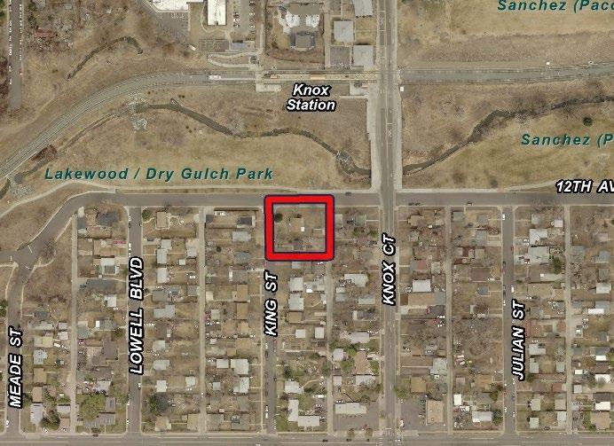
2 Rezoning Application #2017I & 1090 King Street January 3, 2019 Page 2 General Location
.")
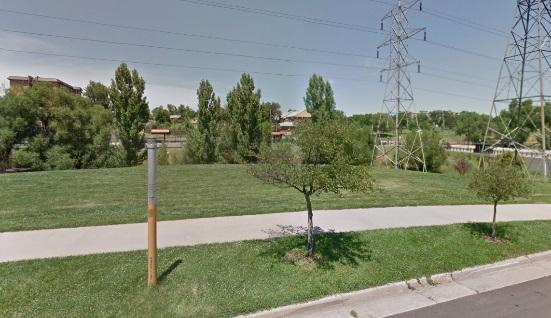
3 Rezoning Application #2017I & 1090 King Street January 3, 2019 Page 3 Existing Context The subject property is in west Denver between 10 th and 12 th Avenues on King Street, ½ block south of the Knox Street Light Rail Station. The subject property is within ¼ mile of the Knox Street Light Rail Station and within ½ mile of two more light rail stations (Decatur/Federal and Perry). In the general vicinity are: West Colfax Avenue 3 blocks north, West 6 th Avenue 5 blocks south Federal Boulevard, 6 blocks east, Lakewood Dry Gulch and Sanchez Parks directly north across 12 th Avenue, Westridge Homes, DHA public housing 2 blocks north, Rodolfo Corky Gonzalez Branch Library 3 blocks north, Rude Park and Recreation Center 6 blocks to the northeast Cheltenham Elementary School 3 blocks north across West Colfax Avenue, Eagleton Elementary School 3 blocks to the southeast, and Presentation of Our Lady Catholic School 4 blocks south. The subject property is surrounded by a mixture of single family and some low density multi-unit residential uses, with embedded commercial uses located on either side of Knox Court at 10 th Avenue. Area building heights range from 1 to 2 stories.

4 Rezoning Application #2017I & 1090 King Street January 3, 2019 Page 4 The following table summarizes the existing context proximate to the subject site: Existing Zoning Existing Land Use Existing Building Form, Scale Site E-SU-D1x Low-rise Residential 1-story Structures North OS-A City Park / Light Rail Line No Structures Existing Block, Lot, Street Pattern Grid street patterns with alleys, mixed attached, detached and no sidewalks. Regular pattern of rectilinear blocks. South E-SU-D1x Low-rise Residential 1-2-story Structures West E-SU-D1x Low-rise Residential 1-2-story Structures East E-SU-D1x Low-rise Residential 1-2-story Structures Existing Zoning The E-SU-D1x zone district is a single unit zone district that allows either a Suburban House or and Urban House primary building form and an accessory dwelling unit, with a minimum zone lot size of 6,000 square feet. Maximum building heights are feet.

5 Rezoning Application #2017I & 1090 King Street January 3, 2019 Page 5 Existing Land Use
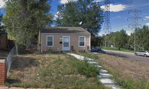
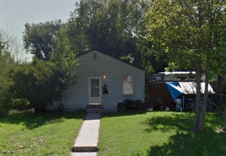
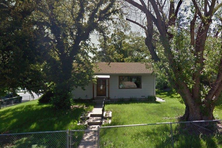
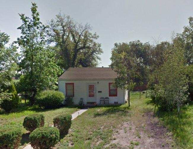
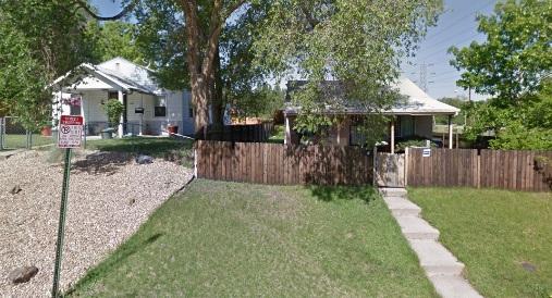
6 Rezoning Application #2017I & 1090 King Street January 3, 2019 Page 6 Existing Building Form and Scale
7 Rezoning Application #2017I & 1090 King Street January 3, 2019 Page 7 Summary of City Agency Referral Comments This rezoning has been reviewed concurrently within the context of the Denver Zoning Code and other applicable City Codes as utilized by the referral agencies listed below. Assessor: No response. Asset Management: No response. Denver Public Schools: No response. Development Services Fire Prevention: No response. Development Services Project Coordination Approve rezoning only will require additional information at Site Plan Review. A Concept plan submittal will be required to ensure that all requirements of the E-RH-2.5 zone district have been met. Development Services Transportation: Approved See comments below. DES Transportation approves the subject zoning change. The applicant should note that redevelopment of this site may require additional engineering, ROW dedication to the City, access changes, traffic studies and/or right of way improvements. The extent of the required design and improvements will be determined once this property begins the redevelopment process. The results of any traffic studies may require the construction of off-site mitigation or may limit the proposed density of the project. Development Services Wastewater: No response. Parks and Recreation: No response. Public Health and Environment: Approved with the following comments: General Notes: Denver Department of Public Health and Environment concurs with the rezoning but is aware of potential environmental concerns near the Property. An area of historical urban fill (HUF) may exist just south of or may extend under the site. The HUF, if encountered during future site development, may contain solid waste or debris that would require proper handling and disposal. General Notes: Most of Colorado is high risk for radon, a naturally occurring radioactive gas. Due to concern for potential radon gas intrusion into buildings, DEH suggests installation of a radon mitigation system in structures planned for human occupation or frequent use. It may be more cost effective to install a radon system during new construction rather than after construction is complete. If renovating or demolishing existing structures, there may be a concern of disturbing regulated materials that contain asbestos or lead-based paint. Materials containing asbestos or lead-based paint should be managed in accordance with applicable federal, state and local regulations. Public Works ROW - City Surveyor: Approved See comments below. The description matches what the Assessor has.
8 Rezoning Application #2017I & 1090 King Street January 3, 2019 Page 8 Public Review Process CPD informational notice of receipt of the initial rezoning application to all affected members of City Council and Registered Neighborhood Organizations and property owners within 200 feet of the subject properties: Property legally posted for a period of 15 days and CPD written notice of the Planning Board public hearing sent to all affected members of City Council, Registered Neighborhood Organizations, and property owners within 200 feet of the subject properties: Planning Board Public Hearing and vote (8-0) to recommend approval: CPD written notice of the Land Use, Transportation and Infrastructure Committee meeting sent to all affected members of City Council and Registered Neighborhood Organizations, at least ten working days before the meeting: Land Use, Transportation and Infrastructure Committee of the City Council: Property legally posted for a period of 21 days and CPD written notice of the City Council public hearing sent to all affected members of City Council and Registered Neighborhood Organizations: Date 09/06/18 12/03/18 12/19/18 12/24/18 01/08/19 01/28/19 (tentative) City Council Public Hearing: 02/19/19 (tentative) Mediation The applicant participated in two mediated discussions with representatives from the Villa Park Neighborhood Association. After discussion of the issues no agreement was reached. See the attached mediation summary. Registered Neighborhood Organizations To date, staff has received one letter of opposition from the Villa Park Registered Neighborhood Organization.
9 Rezoning Application #2017I & 1090 King Street January 3, 2019 Page 9 Other Public Comment To date, staff has received one additional letter of opposition as well as seven letters of support from individual residents. Criteria for Review/Staff Evaluation The criteria for review of this rezoning application are found in DZC, Sections and , as follows: DZC Section Consistency with Adopted Plans 2. Uniformity of District Regulations and Restrictions 3. Public Health, Safety and Welfare DZC Section Justifying Circumstances 2. Consistency with Neighborhood Context Description, Zone District Purpose and Intent Statements 1. Consistency with Adopted Plans The criteria for review of this rezoning application include conformance with adopted regulations, and with the Comprehensive Plan and applicable supplements. Applicable documents are: Denver Comprehensive Plan 2000 Blueprint Denver (2002) West Colfax Plan (2006) Villa Park Neighborhood Plan (1991) Denver Comprehensive Plan 2000 The proposal is consistent with and positively addresses many Denver Comprehensive Plan strategies, including: Environmental Sustainability Strategy 2-B Protect and improve air quality by: Reducing vehicular pollution by expanding the use of transit and other travel alternatives, supporting telecommuting and home-based employment, increasing the mix of uses within neighborhoods, and expanding the use of alternative fuels (p. 38). Environmental Sustainability Strategy 2-F Conserve land by promoting infill development within Denver at sites where services and infrastructure are already in place (p. 39). Land Use Strategy 1-H to Encourage development of housing that meets the increasingly diverse needs of Denver s present and future residents in the Citywide Land Use and Transportation Plan (p. 58). Land Use Strategy 3-B to Encourage quality infill development that is consistent with the character of the surrounding neighborhood; that offers opportunities for increased density and more amenities; and that broadens the variety of compatible uses (p. 60). Land Use Strategy 4-A to Encourage mixed-use, transit-oriented development that makes effective use of existing transportation infrastructure, supports transit stations, increases transit patronage, reduces impact on the environment, and encourages vibrant urban centers and neighborhoods (p. 60).
.")
10 Rezoning Application #2017I & 1090 King Street January 3, 2019 Page 10 Mobility Strategy 3-B Promote transit-oriented development (TOD) as an urban design framework for urban centers and development areas. Development at transit stations should provide both higher ridership to the transit system and viability and walkability in the area (p. 77). Mobility Strategy 5-D Determine the potential for transit-oriented development at public transit stations and encourage such opportunities whenever possible (p. 79). The proposed map amendment will enable the addition of transit oriented development in the form of new low-scale multi-unit residential development directly bordering the W light rail Line. Increasing the diversity of housing types near transit stations increases transit ridership and helps protect the City s air quality. The E-RH-2.5 zone district will introduce more diverse residential development that matches the maximum building height of feet currently allowed in the existing single unit zone district. The location of the subject properties on the northern edge of the Villa Park neighborhood also offers the opportunity for an increase in density that can provide a transition from the transit station to the predominately single family neighborhood. The allowed primary building forms in the E-RH-2.5 zone district are Suburban and Urban House, Tandem House, Duplex, and Row House. The rezoning is consistent with the Comprehensive Plan policies that encourage development of housing that meets the diverse housing needs of the City s residents, of development that offer a discreet increase in density near transit stations and that supports infill development where services and infrastructure are already in place, where the infill development is in character with the existing neighborhood, and that helps protect the air quality of the City. Blueprint Denver Blueprint Denver, the City s Land Use and Transportation Plan, identifies the subject property as being within an Area of Change with a land use recommendation of Urban Residential Blueprint Denver Plan Map
11 Rezoning Application #2017I & 1090 King Street January 3, 2019 Page 11 Future Land Use Urban Residential neighborhoods are higher in density and primarily residential but may include a noteworthy number of complementary commercial uses. New housing tends to be mid- to high-rise structures, and there is a greater housing base than employment base. A mixture of housing types is present, including historic single-family houses, townhouses, small multi-family apartments and sometimes high-rise residential structures (p ). The proposed E-RH-2.5 zone district will bring the density of the proposed property closer to the Urban Residential land use category description by introducing low intensity multi-unit land use. Under the E-RH-2.5 district the variety of housing types allowed on the subject property would increase to include the Duplex, Tandem House, and Row House building forms. This is consistent with the description of housing types included in the description of the Urban Residential land use category. Based on the location of the subject property near the Knox Street light rail station and the envisioned Urban Residential land uses, the E-RH-2.5 zone district is consistent with the Blueprint Denver land use recommendation. Areas of Change/Areas of Stability A central premise of the Blueprint Denver plan is that growth should be directed to Areas of Change. The Plan goes on to describe three types of Areas of Change including [1] Downtown; [2] Lowry, Stapleton and Gateway and [3] Areas where land use and transportation are closely linked (p. 20). The Plan goes on the describe features that characterize Area of Change as areas adjacent to and around transit stations and areas with special opportunities such as where major public or private investments are planned (p. 19). The subject property is adjacent to the Knox Street Light Rail Station on the W Rail Line, a part of the FasTracks project, a major public investment to expand transit in the Denver metro region. The property is also within 1/2 mile of the Decatur-Federal and the Perry Street light rail stations. In this location the property is in an area where transportation and land use are linked. It is therefore appropriate that the subject property is in an Area of Change and that the Plan vision is increased density. The Plan also includes strategies envisioned for these types of Areas of Change including: Compatibility between existing and new development Pedestrian and transit supportive design Mixed land uses Infill and redevelop vacant and underused properties Multi-modal streets Transit service and transit access Diversity of housing type, size, cost Retain low and moderate income residents The proposed E-RH-2.5 zone district is an appropriate step up in density that is still in character with the adjacent neighborhood. The maximum building height in the existing single unit zone district is the same in the E-RH-2.5 zone district, and thus is compatible with the existing development in the area. The E-RH-2.5 district will serve to introduce low-intensity multi-unit housing onto the properties. Street Classifications Blueprint Denver classifies 10 th Avenue as a Residential Collector street and 12 th Avenue and King Street as an Undesignated Local streets. As Collector and local streets residential streets are designed to emphasize walking bicycling and land access over mobility (p. 55), and local

12 Rezoning Application #2017I & 1090 King Street January 3, 2019 Page 12 street are tailored more to providing local access (p. 51). The proposed map amendment will enable a modest increase in residential density appropriate to residential streets. West Colfax Plan (2006) The West Colfax Plan includes a Framework Plan the purpose of which provides the overarching goals and recommendations for these places within the study area; it provides the technical guidance for zoning regulatory changes, infrastructure planning and policy direction (p. 78). Key components of the Framework Plan include Urban Design, Land Use, Mobility and Economic Development. The West Colfax Plan also contains District Plans to provide guidance regarding the appropriate character and scale of an area The district plans augment the prevailing goals and recommendations contained in the framework plan (p. 120). Within the West Colfax Plan Framework Plan, the subject property, is identified in the following ways: Framework Plan/Future Land Use/Urban Design On the Future Land Use Concept map the properties are identified as Urban Neighborhood Station. See the red square on the Future Land Use Concept map below. West Colfax Plan - Future Land Use Concept Map In the West Colfax Plan within Urban Neighborhoods there are two different types described:


13 Rezoning Application #2017I & 1090 King Street January 3, 2019 Page Residential Stabilization Areas - where existing buildings should be preserved, rehabilitated and reused. 2. Residential Growth Opportunity Areas where the existing housing stock is dated and declining, and may be appropriate for redevelopment to encourage revitalization and reinvestment. This site is located within a Residential Growth Opportunity Area. See the Urban Design Concept Map below. West Colfax Plan Urban Design Concept Map Urban Neighborhood Station The land use and urban design concept for the Urban Neighborhood Station future land use designation is Single family and multi-family residential with a typical scale of 1-5 stories. This land use development pattern occurs within a 1/4 to 1/2 mile radius of light rail stations in
14 Rezoning Application #2017I & 1090 King Street January 3, 2019 Page 14 the central city of a metropolitan region. Generally, development happens here as infill on vacant parcels or redevelopment of underutilized parcels or dated and declining properties. Since the stations evolve in established residential areas, initial changes may add density and intensity in compact building forms that blend in with the prevailing residential context. Development may progress initially from residential additions and rehabilitations to the addition of carriage houses and conversion of single-family structures to duplexes, triplexes and quads. Over the long-term, some more significant and welcome redevelopment may occur, adding small and medium scale apartments or condominium buildings in close proximity to the station areas (p. 85). Additional Framework Plan Land Use Recommendations include: Recommendation 1: Urban Neighborhood Regulatory Tools Work with the Zoning Code Task Force to establish and apply form based zoning tools appropriate for the mix of building types and uses (primarily housing and complementary uses) that define an urban neighborhood and their associated station areas. Ensure that these zoning tools consider, define and respect the traditional and desired forms of urban neighborhood patterns of development. Consider: Urban design (lot and block structure, site design, building orientation, setbacks, relationship of buildings to streets) Range of building types (single family structures, duplexes, triplexes, quads, courtyard apartments, carriage houses, row houses, town homes) and associated design elements (entries, balconies, stoops, materiality, glazing) Architectural character (building envelope, scale, proportions, materiality, rhythm, massing and height) Location criteria for certain building types and uses to ensure the evolution of the appropriate urban neighborhood texture that complements the transportation network: o Ensure rational evolution of urban neighborhoods and their station areas, so that changes in development intensities occur in harmony with prevailing neighborhood character. o Correlate higher intensity structures within close proximity of station area platforms or as end cap buildings on block faces fronting busy neighborhood streets (p. 94). Recommendation 6: Housing Diversification Diversify housing options and encourage a healthy urban mix of incomes. Promote a range of housing types and costs at higher densities in strategic locations (town centers, station areas, main streets) (p. 95). Recommendation 8: Transitions To the greatest extent possible, focus both structural and use intensity to main streets, transit station areas and town centers. Incorporate design and development standards to address solar access and privacy protection, such as bulk plane, building orientation and roof form standards. (p. 96).
.")

15 Rezoning Application #2017I & 1090 King Street January 3, 2019 Page 15 District Plans In addition to the Framework Plan, the West Colfax Plan includes District Plans. The district plans do not imply zoning changes but are included in the Plan to provide guidance regarding the appropriate character and scale of an area (p. 120). Maple Grove Transit Station District Plan: The West Colfax Plan includes the subject site within the Maple Grove Transit Station. See the red square on the District Plans map below. Specific to the neighborhood stations, the Plan offers the following District Plan recommendations: Recommendation 1: Urban Neighborhood Station Elements Establish the appropriate regulatory conditions and incentives to facilitate the redevelopment of the edges of Villa Park and West Colfax neighborhoods near the rail facilities, as well as the catalyst development sites at Avondale and Westridge. Incorporate special features to reinforce stations as a key transit transfer point or stop. Recommendation 2: Redevelopment of Station Areas Maple Grove Station. Maple Grove Station presents the greatest opportunity for redevelopment. Advance planning should explore the opportunity to use Decatur Station as an initial staging area for the redevelopment of Avondale, the Overlook Apartments, Westridge Homes and other nearby obsolete/dated public housing facilities as higher density, healthier mixed-income communities. East of Lowell [Boulevard], encourage redevelopment at higher intensity to improve the housing stock and residential densities as the district approaches the Avondale shopping center (p. 142). West Colfax Plan District Plans Map
16 Rezoning Application #2017I & 1090 King Street January 3, 2019 Page 16 The common theme in the West Colfax Plan recommendations for the subject property is that the property is recommended to transition to more intense station/urban residential land uses centered near the stations along the West Light Rail Line. The Urban Neighborhood Station recommended land use concept describes a range of housing types that include single family and multi-family land uses. To conform with the Urban Neighborhood Station concept (within ¼ to ½ mile of the station) the Plan recommends adding density and intensity in compact building forms that blend in with the prevailing residential context and building heights of 1-5 stories. The proposed zoning for the subject site, E-RH-2.5, will increase the range of residential housing types and will control the scale of future development to the same scale as the surrounding residential development. With the allowed low-intensity multi-unit building forms, residential uses, and feet height restrictions featured the E-RH-2.5 zone district, the zone district is consistent with the West Colfax Plan. Villa Park Neighborhood Plan (1991) The Villa Park Neighborhood Plan was adopted in The land use and zoning vision expressed in the Plan is: Compatibility of zoning to land use Protection of residential character of the neighborhood Compatibility between residential and business land uses (p. 18) Land Use and Zoning Plan Recommendations include: Strategy LZ-1: Discourage higher density development. Implementation Program LZ-1a: Consider rezoning portions of the neighborhood. Zoning is intended to reflect both the current and the desired character of an area. However, while most of the housing in Villa Park is single-unit, the zoning throughout much of the neighborhood, R-2, allows and encourages the development of low density apartments. The property owners in those areas, therefore, should consider rezoning to a lower density residential zone, which would more accurately reflect the existing and desired character of the neighborhood (p.18). Strategy LZ-2: Discourage development that is incompatible with the scale and quality of the neighborhood. Implementation Program LZ-2a: Monitor requests for rezoning and for zoning variances The proposed E-RH-2.5 zone district complies with the land use and zoning vision of the Villa Park Neighborhood Plan in terms of protecting the residential character of the neighborhood because the proposed zone district is a residential district and in terms of compatibility because the E-RH-2.5 height limit is the same as the height limit in the current zone district. The Plan recommendation discouraging higher density development predated the public investment in the development of the adjacent light rail line, and the development of more current land use recommendations in Blueprint Denver and the West Colfax Plan. The E-RH-2.5 zone district is a district that both respects the character of the existing neighborhood in terms of building height and residential land use type and allows for a reasonable increase in density given the location of the property in close proximity to the Knox Street light rail station.
17 Rezoning Application #2017I & 1090 King Street January 3, 2019 Page Uniformity of District Regulations and Restrictions: Rezoning the site to E-RH-2.5 will further the uniform application of district regulations in the City. The same regulations will apply to the subject site as to other areas zoned E-RH-2.5 in the city. 3. Public Health, Safety and General Welfare: The proposed map amendment furthers the public health, safety and general welfare of the City by implementing the vision set forth in the City s adopted plans, by allowing low intensity redevelopment that is in character with the surrounding neighborhood and by advancing transit-oriented development to help protect the City s air quality. 4. Justifying Circumstances The application identifies the changing conditions immediately north of the properties along the West Corridor Light Rail line as the Justifying Circumstance under DZC Section A, Since the date of the approval of the existing zone district, there has been a change to such a degree that the proposed rezoning is in the public interest. Such change may include: Changed or changing conditions in a particular area, or in the city generally; or a city adopted plan; or that the city adopted the Denver Zoning Code and the property retained Former Chapter 59 zoning. The proposed map amendment is in response to the changed circumstances of light rail transit serving the area, the new W light rail line and Decatur-Federal and Perry Street stations in the vicinity. Staff believes changed conditions is an appropriate justifying circumstance. 5. Consistency with Neighborhood Context Description, Zone District Purpose and Intent Statements The fifth review criterion in the Denver Zoning Code is that the proposed official map amendment must be consistent with the descriptions of the applicable neighborhood context, and with the stated purpose and intent of the proposed zone district. Overall, the proposed map amendment is consistent with the Urban Edge Neighborhood Context. The Denver Zoning Code describes the Urban Edge context as characterized by a mix of elements from both the Urban and Suburban Neighborhood Contexts. The Urban Edge Neighborhood Context is primarily single-unit and two-unit residential uses. Small-scale multi-unit residential uses and commercial areas are typically embedded in residential areas. Single-unit residential structures are typically Urban House forms with some Suburban House forms. Multi-unit forms are typically Row House, or Apartment forms embedded with other residential forms. Commercial buildings are typically Shopfront and General forms that typically contain a single type of use. Street and block patterns are a regular pattern of block shapes surrounded by an orthogonal street grid. Block sizes and shapes are consistent and primarily include detached sidewalks (though attached sidewalks are also found), tree lawns where provided for by detached sidewalks, street and surface parking, and landscaping in the front setback. The Urban Edge residential zone districts are intended to promote and protect residential neighborhoods within the character of the Urban Edge Neighborhood Context. These regulations allow for some multi-unit districts, but not to such an extent as to detract from the overall image and character of the residential neighborhood The building form standards, design standards, and uses work together to promote desirable residential areas The standards of the two unit and town house districts promote existing and future patterns of lower scale multi-unit building forms that typically address the street in the same manner as an urban house building form. Specifically the E-RH-2.5 zone district is a multi-unit district
18 Rezoning Application #2017I & 1090 King Street January 3, 2019 Page 18 and allows suburban house, urban house, detached accessory dwelling unit, duplex, tandem house and row house building forms up to two stories in height. The proposed map amendment is consistent with both the general and specific purpose and intent of the Urban Edge context and the E-RH-2.5 zone district because the proposed zoning will promote new a low density transit oriented residential development that is in character with the existing neighborhood in scale and land use type. Attachments: 1. Mediation Report 2. Application 3. Legal Description 4. Comment Letters (2)

19 Community Mediation Concepts A NONPROFIT ORGANIZATION PROVIDING MEDIATION, CONFLICT RESOLUTION AND FACILITATION SERVICES Helping People Talk to People December 7, 2018 Theresa Lucero, Senior City Planner Community Planning and Development City and County of Denver Dear Theresa: Thank you for referring the rezoning request for 1080 & 1090 North King Street, Denver, Colorado to mediation. I contacted Bruce O Donnell, who is representing Paul Malone, the applicant, and they were both willing to mediate. I contacted the representative for Villa Park Neighborhood Association, who agreed to pull together the appropriate group to represent the neighborhood and enter into mediation. However, as you know getting timely responses or being able to schedule was impossible. I m sorry for how long this process took. Ultimately, we were able to meet on October 29, In attendance were five representatives from Villa Park Neighborhood Association (VPNA), the applicant and Mr O Donnell. Mr Malone presented his request for rezoning and explained in detail what he was proposing to build on these two lots. There was a significant amount of discussion. We left that meeting with the understanding that while VPNA still had questions about the impact on their neighborhood and was uncertain if they could support the number of units being proposed; that if certain listed criteria could be met, then it was possible, maybe even probable, the neighborhood would support a rezoning. We reconvened on November 11, Mr Malone and Mr O Donnell asked for this amount of time to see if they would be able to meet and commit to the requests the neighbors had presented. Prior to our meeting, Mr O Donnell ed to the group a proposed Memorandum of Understanding, Deed Restrictions and Protective Covenants detailing and fully addressing each of the neighbors concerns and requests through design, setbacks, materials, and environmentally. At our November 11 th meeting we reviewed the plans, discussed each of the specific requests VPNA had made and how they were addressed and fulfilled by the revised proposal. It was an amiable discussion, VPNA appreciated the efforts Mr Malone had made; BUT said they truly believe and are convinced that only single family homes would really contribute to the stability, character, and sustainability of what they all loved in their neighborhood. Please don t hesitate to contact me with any questions. Sincerely yours, Steve Charbonneau Executive Director, Community Mediation Concepts Steve@FindSolutions.org
20 DATE: le-1- tg NAM E: )o* k ao,,tc-t, lh"m t>,, t \ -l g1 ADDRESS: l01f.jui,rn^ t+ SUBJECT: Rezoning of 1080 & 1090 King Street To: Members of the Denver Planning Board c/o Ms. Theresa Lucero, City of Denver - Community Planning and Development I am a resident of Villa Park and a neighbor of the 1080 / 1090 King St property that is seeking rezoning to E-RH-2.5. I a m contacting you to express my support for th is rezon ing and to encourage the Planning Board to recommend approval of the rezoning request to Denver City Council. Row House zoning in this Blueprint Denver ldentified Area of Change will enable reinvestment and redevelopment ofthis property which, on the south side of Lakewood Dry Gulch, is practically as close as you can get to the Knox Station on the RTD "W" light rail line. As a City we should be taking advantage of the public investment in transit and encouraging density near transit stops like at Knox station. This is supported in the West Colfax Plan which classifies this area as Urban Neighborhood Station and prescribes single and multi-family residential buildings of 1to 5 stories in height. Because this site is south of Lakewood Dry Gulch E-RH-2.5 is the perfect choice for new zoning to respect the scaie and character of Villa Park while also tbcusing more densrty and reinvestment at this Knox Station TOD opportunity. For these reasons I am pleased to be supportive of this rezoning application and hope that the Planning Board will be too. Sinc v4-
21 Villa Park Neighborhood Association December 13, 2018 Attn: Theresa Lucero, Case Manager Planning Services Community Planning and Development 201 W. Colfax Avenue Dept. 205 Denver, CO Re: King St: Dear Planning Board, Villa Park Neighborhood Association (VPNA) members at its general monthly neighborhood association meeting at 6:30 p.m. on November 28, 2018 reviewed the proposed rezoning of King St: Villa Park Neighborhood Association boundaries are from Federal Blvd to Sheridan Blvd and from 6 th Ave to the 12 th Ave gulch border and is a registered neighborhood organization with the City of Denver. The property owners and/or residents of our neighborhood can become members of the association by attending the association meetings three times a year. At this meeting we had a vote of nine against and three for the rezoning and one abstention. Neighbors are informed of upcoming zoning issues by either coming to our monthly meetings, the Villa Park Neighborhood Association web site or our newsletter. We did not hear from any other members or residents regarding this zoning issue. Based on the rezoning criteria this application does not meet the criteria in several areas. The rezoning is not consistent with adopted plans. For example, the Villa Park Neighborhood Plan strategy LZ-1: discourages higher density development that is inconsistent with the neighborhood character, quality and scale of the surrounding neighborhood. As illustrated in the staff report this proposed development is surrounded by E-SU-D1X zoning which is single family dwelling units. Prior to the form based zoning ordinance in 2010 the area of King St was zoned R-1 and continued with this type of zoning under the E-SU-D1X category. The 2010 form based zoning also included several areas in the Villa Park Neighborhood that included the E-RH 2.5 and by and large these zoned areas have not seen much redevelopment. This proposal would be more in sync with the E-RH- 2.5 zoning that is already zoned in the neighborhood with more compatible neighborhood character, scale and quality. The rezoning application of is not consitent with the Comprehensive Plan. The Comprehensive Plan for Denver under the Land Use Strategies 1-C of incorporating relevant recommendations from neighborhood, corridor and area plans, this application is counter to the Villa Park Neighborhood Plan in regards to preserving the neighborhood character, quality and scale of the neighborhood. Under the City of Denver s Comprehensive Plan in Housing Section, strategies 2-B & 3-B it lists the need to preserve existing housing, support stablization programs that help people stay in their homes, and under objective 5; it states to support home ownership for low and middle-income households to become home owners. The Denver Liviability Partnership/Housing Development Fund, along with the Villa Park Plan, West Colfax Plan explicitly notes the need to maintain stablized areas of neighborhoods. If this rezoning is approved it will reduce the preservation of existing houses and will not stablize the neighborhood with a price point of $450,000 per unit. Villa Park Neighborhood Association, P.O Box Edgewater, CO
22 Villa Park Neighborhood Association In regards to the criteria of public need, this proposal clearly is not meeting a public need since it would be eliminating current affordable housing. The neighborhood character of this area is stable but will quickly become unstable with the change in housing prices of $450,000 per unit as a start point. Villa Park is one of the few affordable housing areas in the city. The comparable sales in this area and overwhelmingly the housing sale price varies from $120,000 to $250,000 which is well below the median in the city. This further illustrates the affordablity of Villa Park. If this rezoning is approved, the city with be eliminating affordable housing for Denver residents. Villa Park Neighborhood states that this rezoning application does not meet the public need criteria for affordable housing. Regarding the criteria of Justisfying Circumstances, Villa Park has met with this developer several times and it has always been the position of the developer and initally their original zoning application to redevelopment only one lot which they owned in Then the project expanded to the lot at 1080 King St with their revised application in 2018 that created an assemblage of properties approximately 15,625 square footage of the combine lots. The rezoning to E-RH-2.5 with this project will encompass a solid wall front of 115 feet without any massing relief. The units are 12 feet wide by 45.6 feet and two stories. The width of these units are barely larger then a couch and are assembled in a shot gun fashion with a small open space section behind each unit of appoximately 15 by 12 feet and then a one-car garage finishing the rest of each unit to the alley and again creating another solid wall massing on the back side of the lot of 115 feet. The determinate characteristic of these units would create such a contrast with the rest of the surrounding Villa Park Neighborhood and on the block of King Street that it is inconsistent with the neighborhood context and zoning district purpose. The character of the neighborhood around King St reflects the single-family dwelling unit or E-SU-D1X. The area has not have many changes and basically is single family. The applicant does not have justisfying circumstances to rezone this area as stated in the application since the surrounding areas in Villa Park is not changing and this rezoning application proposal is out of character with the Villa Park Neighborhood and does not meet this criteria. I encourage the Planning Board to evaluate the changes in the Villa Park Neighborhood that is affected with building permit activity. Under the rezoning criteria of neighborhood context, this proposal as stated earlier falls short in this area. The context of the neighborhood is single-family dwelling units that were develop when Villa Park was platted. The pattern of residential development has remained consistent in this area. Under the form-based zoning update, Villa Park noted that the higher density housing development would occur along the Sheridan Light Rail Station where the zoning allowed for this transition. In addition the Federal Blvd Corridor was noted for more mix use zoning with the predominat commerical area of the neighborhood. Both of these areas would be more in neighborhood context to what the developer is proposing. In fact in looking at the composition of the proposed development the 9 unit development will only have 2 bedrooms per unit. The area being displaced have additional room for additions on the main structure but also the option of the Accessory Dwelling Unit (ADU). Families in Villa Park may have 4 to 5 members per household and with the development of an additional ADU unit the total household count could easily bring it up to 8 or 9 members which would be very similar to the density of the proposed development. So are we really creating more density or just bigger buildings. The change that has occurred in west Denver has predominately occurred in the West Colfax neighborhood where the zoning is at a higher density level. Based on the justification found in the aforementioned plans, the proposed rezoning from E-DU-1X to E-RH-2.5 will not result in the uniform application of the zone district, building form, use and design regulations to all buildings within the subject area. Villa Park Neighborhood Association, P.O Box Edgewater, CO
23 Villa Park Neighborhood Association Therefore, the Planning Board should deny this rezoning application based on the the rezoning criteria. This rezoning application: does not have consistency with adopted plans, falls short in demonstrating uniformity of district regulations and restrictions, lacks in the demonstration of a public need for the rezoning, and does not have justifying circumstances in illustrating the land surrounding the proposed rezoning area is changing in Villa Park. This concludes Villa Park Neighborhood Association position statement. Respectfully Submitted by Kathy Sandoval on behalf of the Villa Park Neighborhood Association Villa Park Neighborhood Association, P.O Box Edgewater, CO
24
25 From: Rick Levy To: Lucero, Theresa - CPD Sr City Planner Subject: [EXTERNAL] Proposed Rezone Case 17i-00178: 1080 & 1090 N King St: 2017I Date: Monday, December 17, :26:29 AM Greetings Senior City Planner Lucero, I am a resident of the Villa Park neighborhood, living at the corner of 10th Ave and Hazel Ct. I would like to submit the following comments concerning the proposed rezoning at 1080 and 1090 King Street in the neighborhood. The proposed rezoning from a single unit (E-SU-D1x) to a multi unit set of row homes (E-RH- 2.5) seems, to me, my family, and my neighbors to be another step in the wrong direction for Villa Park and for Denver. As you know, the vast majority of the neighborhood, especially on the eastern side, is comprised of single family homes. This gives the neighborhood its own charming character. Folks have large yards for their kids and pets to play in, and for many to build into beautiful gardens that lend to the city's sustainability goals as well as the city's effort to become a certified wildlife habitat. While the homes are modest, they offer an affordable place for a diverse community to call home, near mass transit, a library, schools, parks, and recreation centers. The slow, but already underway, endeavor to reshape our neighborhood into something that it is not concerns me greatly. Developers come in and buy homes at a relatively low price, and then apply to change the very character of the neighborhood by changing the zoning. Then they construct shoddy row homes that they sell for well above the mean price in the neighborhood. We have seen this play out across the city, especially on the west side of Denver. I see no reason why the developer cannot simply renovate or build new constructions that fit the current zoning and the character of the neighborhood. I urge you and the city to consider the slippery slope that has already begun within Villa Park, and how further rezoning of the neighborhood will change its character for the worse, causing congestion, pollution, less room for vegetation, and less affordability. Sincerely, Rick Levy 995 Hazel Ct, Denver Colorado Rick Levy
26 DATE: 12/12/18 NAME: Adam Cole ADDRESS: 927 Raleigh St Denver CO SUBJECT: Rezoning of 1080 & 1090 King Street TO: Members of the Denver Planning Board c/o Ms. Theresa Lucero, City of Denver Community Planning and Development I am a resident of Villa Park and a neighbor of the 1080 / 1090 King St property that is seeking rezoning to E-RH-2.5. I am contacting you to express my support for this rezoning and to encourage the Planning Board to recommend approval of the rezoning request to Denver City Council. Row House zoning in this Blueprint Denver identified Area of Change will enable reinvestment and redevelopment of this property which, on the south side of Lakewood Dry Gulch, is practically as close as you can get to the Knox Station on the RTD W light rail line. As a City we should be taking advantage of the public investment in transit and encouraging density near transit stops like at Knox station. This is supported in the West Colfax Plan which classifies this area as Urban Neighborhood Station and prescribes single and multi-family residential buildings of 1 to 5 stories in height. Because this site is south of Lakewood Dry Gulch E-RH-2.5 is the perfect choice for new zoning to respect the scale and character of Villa Park while also focusing more density and reinvestment at this Knox Station TOD opportunity. For these reasons I am pleased to be supportive of this rezoning application and hope that the Planning Board will be too. Sincerely,
27
28
29


30 SUBJECT: Rezoning of 1080 & 1090 King Street TO: Members of the Denver Planning Board c/o Ms. Theresa Lucero, City of Denver Community Planning and Development I am a owner of property in Villa Park at 1027 Julian Street, 735 King Street and 738 Tennyson Street and a neighbor of the 1080 / 1090 King St property that is seeking rezoning to E-RH-2.5. I am contacting you to express my support for this rezoning and to encourage the Planning Board to recommend approval of the rezoning request to Denver City Council. Row House zoning in this Blueprint Denver identified Area of Change will enable reinvestment and redevelopment of this property which, on the south side of Lakewood Dry Gulch, is practically as close as you can get to the Knox Station on the RTD W light rail line. As a City we should be taking advantage of the public investment in transit and encouraging density near transit stops like at Knox station. This is supported in the West Colfax Plan which classifies this area as Urban Neighborhood Station and prescribes single and multi-family residential buildings of 1 to 5 stories in height. Because this site is south of Lakewood Dry Gulch E-RH-2.5 is the perfect choice for new zoning to respect the scale and character of Villa Park while also focusing more density and reinvestment at this Knox Station TOD opportunity. For these reasons I am pleased to be supportive of this rezoning application and hope that the Planning Board will be too. Thank you very much. Kind Regards, Ben Maxwell Mangager ben@hmcapitalgroup.com Pecos Street; Suite 200; Denver, CO 80211
31 Villa Park Neighborhood Association December 13, 2018 Attn: Theresa Lucero, Case Manager Planning Services Community Planning and Development 201 W. Colfax Avenue Dept. 205 Denver, CO Re: King St: Dear Planning Board, Villa Park Neighborhood Association (VPNA) members at its general monthly neighborhood association meeting at 6:30 p.m. on November 28, 2018 reviewed the proposed rezoning of King St: Villa Park Neighborhood Association boundaries are from Federal Blvd to Sheridan Blvd and from 6 th Ave to the 12 th Ave gulch border and is a registered neighborhood organization with the City of Denver. The property owners and/or residents of our neighborhood can become members of the association by attending the association meetings three times a year. At this meeting we had a vote of nine against and three for the rezoning and one abstention. Neighbors are informed of upcoming zoning issues by either coming to our monthly meetings, the Villa Park Neighborhood Association web site or our newsletter. We did not hear from any other members or residents regarding this zoning issue. Based on the rezoning criteria this application does not meet the criteria in several areas. The rezoning is not consistent with adopted plans. For example, the Villa Park Neighborhood Plan strategy LZ-1: discourages higher density development that is inconsistent with the neighborhood character, quality and scale of the surrounding neighborhood. As illustrated in the staff report this proposed development is surrounded by E-SU-D1X zoning which is single family dwelling units. Prior to the form based zoning ordinance in 2010 the area of King St was zoned R-1 and continued with this type of zoning under the E-SU-D1X category. The 2010 form based zoning also included several areas in the Villa Park Neighborhood that included the E-RH 2.5 and by and large these zoned areas have not seen much redevelopment. This proposal would be more in sync with the E-RH- 2.5 zoning that is already zoned in the neighborhood with more compatible neighborhood character, scale and quality. The rezoning application of is not consitent with the Comprehensive Plan. The Comprehensive Plan for Denver under the Land Use Strategies 1-C of incorporating relevant recommendations from neighborhood, corridor and area plans, this application is counter to the Villa Park Neighborhood Plan in regards to preserving the neighborhood character, quality and scale of the neighborhood. Under the City of Denver s Comprehensive Plan in Housing Section, strategies 2-B & 3-B it lists the need to preserve existing housing, support stablization programs that help people stay in their homes, and under objective 5; it states to support home ownership for low and middle-income households to become home owners. The Denver Liviability Partnership/Housing Development Fund, along with the Villa Park Plan, West Colfax Plan explicitly notes the need to maintain stablized areas of neighborhoods. If this rezoning is approved it will reduce the preservation of existing houses and will not stablize the neighborhood with a price point of $450,000 per unit. Villa Park Neighborhood Association, P.O Box Edgewater, CO
#2017I E-RH-2.5 Highland Ventures Holdings, LLC and Irving Estates, LLC
 TO: Denver Planning Board - Joel Noble, Chair FROM: Theresa Lucero, Senior City Planner DATE: RE: Official Zoning Map Amendment Application #2017I-00178 1080 and 1090 King Street Rezoning from E-SU-D1x
Staff Report and Recommendation
 Community Planning and Development Planning Services 201 W. Colfax Ave., Dept. 205 Denver, CO 80202 p: 720.865.2915 f: 720.865.3052 www.denvergov.org/cpd TO: City Council Neighborhoods and Planning Committee
Staff Report and Recommendation Based on the criteria for review in the Denver Zoning Code, Staff recommends approval for Application #2017I
 TO: Denver City Council Land Use, Transportation and Infrastructure Committee FROM: Theresa Lucero, Senior City Planner DATE: RE: Official Zoning Map Amendment Application #2017I-00149 Staff Report and
TO: Denver Planning Board FROM: Analiese Hock, Senior City Planner DATE: March 13, 2018 RE:
 Community Planning and Development Planning Services 201 W. Colfax Ave., Dept. 205 Denver, CO 80202 p: 720.865.2915 f: 720.865.3052 www.denvergov.org/cpd TO: Denver Planning Board FROM: Analiese Hock,
Official Zoning Map Amendment Application #2018I-00047
 Community Planning and Development Planning Services 201 W. Colfax Ave., Dept. 205 Denver, CO 80202 p: 720.865.2915 f: 720.865.3052 www.denvergov.org/cpd TO: Denver Planning Board FROM: Chandler Van Schaack,
2 nd & St Paul, LLC and BAH-PLA, LLC
 Community Planning and Development Planning Services 201 W. Colfax Ave., Dept. 205 Denver, CO 80202 p: 720.865.2915 f: 720.865.3052 www.denvergov.org/cpd TO: Denver City Council FROM: Theresa Lucero, Senior
REZONING GUIDE. Zone Map Amendment (Rezoning) - Application. Rezoning Application Page 1 of 3. Return completed form to
 - Application. Rezoning Application Page 1 of 3. Return completed form to") Zone Map Amendment (Rezoning) - Application COMMUNITY PLANNING & DEVELOPMENT REZONING GUIDE Rezoning Application Page 1 of 3 PROPERTY OWNER INFORMATION* CHECK IF POINT OF CONTACT FOR APPLICATION Property
Zone Map Amendment (Rezoning) - Application COMMUNITY PLANNING & DEVELOPMENT REZONING GUIDE Rezoning Application Page 1 of 3 PROPERTY OWNER INFORMATION* CHECK IF POINT OF CONTACT FOR APPLICATION Property
Staff Report and Recommendation Based on the criteria for review in the Denver Zoning Code, Staff recommends approval for Application #2018I
 Community Planning and Development Planning Services 201 W. Colfax Ave., Dept. 205 Denver, CO 80202 p: 720.865.2915 f: 720.865.3052 www.denvergov.org/cpd TO: Denver Planning Board FROM: Sara White, AICP,
September 25th, 2018 $2000 fee pd CC
 2.7267 acres 2018I-00075 September 25th, 2018 $2000 fee pd CC Rezoning Review Criteria Analysis - Map Amendment Application Number: 2018I-00075 805 W. 38 th Avenue October 19, 2018 (amd.) September 17,
Official Zoning Map Amendment Application #2018I-00077
 Community Planning and Development Planning Services 201 W. Colfax Ave., Dept. 205 Denver, CO 80202 p: 720.865.2915 f: 720.865.3052 www.denvergov.org/cpd TO: Denver Planning Board FROM: Scott Robinson,
Denver Land Use, Transportation and Infrastructure Committee FROM: Andrew Webb, Senior City Planner DATE: March 22, 2018 RE:
 Community Planning and Development Planning Services 201 W. Colfax Ave., Dept. 205 Denver, CO 80202 p: 720.865.2915 f: 720.865.3052 www.denvergov.org/cpd TO: Denver Land Use, Transportation and Infrastructure
, C-MS I June 3, 2016 $1500 pd chk #216918
 , C-MS-8 LOTS 21 THROUGH 40, INCLUSIVE, BLOCK 299 CLEMENTS ADDITION TO THE CITY OF DENVER SOUTHEAST QUARTER OF SECTION 34, TOWNSHIP 3 SOUTH, RANGE 68 WEST, SIXTH PRINCIPAL MERIDIAN, CITY
REZONING GUIDE. Zone Map Amendment (Rezoning) - Application. Rezoning Application Page 1 of 3. Return completed form to
 - Application. Rezoning Application Page 1 of 3. Return completed form to") Zone Map Amendment (Rezoning) - Application COMMUNITY PLANNING & DEVELOPMENT REZONING GUIDE Rezoning Application Page 1 of 3 PROPERTY OWNER INFORMATION* CHECK IF POINT OF CONTACT FOR APPLICATION Property
Zone Map Amendment (Rezoning) - Application COMMUNITY PLANNING & DEVELOPMENT REZONING GUIDE Rezoning Application Page 1 of 3 PROPERTY OWNER INFORMATION* CHECK IF POINT OF CONTACT FOR APPLICATION Property
To: S-MX-8 AIO, S-MX-8A AIO, S-MX-12 AIO, C-MX-8 AIO, C-MX-12 AIO, and S-CC-5 AIO
 Community Planning and Development Planning Services 201 W. Colfax Ave., Dept. 205 Denver, CO 80202 p: 720.865.2915 f: 720.865.3052 www.denvergov.org/cpd TO: City Council Neighborhoods and Planning Committee
Official Zoning Map Amendment Application #2018I-00075
 Community Planning and Development Planning Services 201 W. Colfax Ave., Dept. 205 Denver, CO 80202 p: 720.865.2915 f: 720.865.3052 www.denvergov.org/cpd TO: Denver Planning Board FROM: Scott Robinson,
Planning Services Community Planning and Development 201 W. Colfax Ave., Dept. 205 Denver, CO p
 TO: Denver Planning Board, Julie Underdahl, Chair FROM: Theresa Lucero, Senior City Planner DATE: RE: Official Zoning Map Amendment Application #2017I-00042 Staff Report and Recommendation Based on the
LEED-ND 101: Practical Strategies for Achieving Sustainability Goals. Travis Parker Lakewood Planning Director
 LEED-ND 101: Practical Strategies for Achieving Sustainability Goals Travis Parker Lakewood Planning Director Metro Vision Idea Exchange Oct 11, 2012 West Corridor Stations West Corridor Overview West
TO: Staff Report and Recommendation
 Community Planning and Development Planning Services 201 W. Colfax Ave., Dept. 205 Denver, CO 80202 p: 720.865.2915 f: 720.865.3052 www.denvergov.org/cpd TO: City Council Neighborhoods and Planning Committee
Staff Report and Recommendation
 Community Planning and Development Planning Services 201 W Colfax Ave, Dept 205 Denver, CO 80202 p: 720-865-2972 f: 720-865-3056 www.denvergov.org/planning TO: LUTI FROM: Steve Nalley, Senior City Planner
Planning & Zoning Commission Staff Report
 Planning & Zoning Commission Staff Report Meeting Date: May 26, 2015 Drafted by: Katherine Harrison-Rogers CASE # Z2886 PROJECT NAME: APPLICANT/ REPRESENTATIVE: Shawna Runyan PROPERTY OWNER: 1840 (previously
178 Carruthers Properties Inc.
 178 Carruthers Properties Inc. Planning Rationale for 178 Carruthers Avenue Site Plan Control Application June 2014 Table of Contents 1.0 Introduction 2.0 Overview of Subject Property 3.0 Current Zoning
A. WHAT IS A GENERAL PLAN?
 I. Introduction A. WHAT IS A GENERAL PLAN? A general plan is the planning guideline for the future of a city. It contains goals and policies which regulate urban development, the protection of the natural
Land Use Amendment in Southwood (Ward 11) at and Elbow Drive SW, LOC
 at and Elbow Drive SW, LOC") 2018 November 15 Page 1 of 10 EXECUTIVE SUMMARY This land use amendment application was submitted by Rick Balbi Architect on 2017 August 31 on behalf of Sable Developments Ltd, and with authorization from
2018 November 15 Page 1 of 10 EXECUTIVE SUMMARY This land use amendment application was submitted by Rick Balbi Architect on 2017 August 31 on behalf of Sable Developments Ltd, and with authorization from
AWH REPORT OF THE PLANNING AND DEVELOPMENT DEPARTMENT FOR APPLICATION FOR REZONING ORDINANCE TO PLANNED UNIT DEVELOPMENT
 AWH REPORT OF THE PLANNING AND DEVELOPMENT DEPARTMENT FOR APPLICATION FOR REZONING ORDINANCE TO PLANNED UNIT DEVELOPMENT MAY 8, 2014 The Planning and Development Department hereby forwards to the Planning
Steering Committee Meeting
 Neighborhood Planning Initiative NPI EAST CENTRAL AREA PLAN Steering Committee Meeting November 9, 2017 6:00PM 8:00PM Tears McFarlane House East Central Area Plan Steering Committee Meeting 11/9/17 AGENDA
Sheridan Station Area Plan. Sheridan. Station Area Plan. Community Planning & Development
 Sheridan Station Area Plan Sheridan Station Area Plan Community Planning & Development Adopted June 8, 2009 Sheridan Station Area Plan Table of Contents Executive Summary i Introduction 1 Vision and Goals
PSRC REVIEW REPORT & CERTIFICATION RECOMMENDATION
 PSRC REVIEW REPORT & CERTIFICATION RECOMMENDATION KITSAP COUNTY COUNTYWIDE PLANNING POLICIES July 2, 2012 BACKGROUND A major emphasis of the Washington State Growth Management Act (GMA) is the need to
Planning Commission April 4, 2013 BOCC Workshop Page 1
 Planning Commission April 4, 2013 BOCC Workshop Page 1 Planning Commission April 4, 2013 BOCC Workshop Page 2 Planning Commission April 4, 2013 BOCC Workshop Page 3 Planning Commission April 4, 2013 BOCC
4.1.3 LAND USE CATEGORIES
 4.1.3 LAND USE CATEGORIES a. City Center District The City Center District incorporates the existing character and mix of uses in downtown Belmont to encourage redevelopment and new development in keeping
DENVER DESIGN DISTRICT GDP
 DENVER DESIGN DISTRICT GDP Urban Design Standards and Guidelines November 17, 2008 Amended February 3, 2016 City and County of Denver CF Property Management, Inc. C/O Denver Design District - Starboard
CONTENTS 8.0 LAND USE 8.1 GENERAL LAND USE 8.2 RESIDENTIAL 8.3 MIXED USE 8.4 COMMERCIAL 8.5 EMPLOYMENT LANDS
 8-2 Land Use 8.0 LAND USE CONTENTS 8.1 GENERAL LAND USE 8.1.1 Uses provided for in all Land Use Designations 8.1.2 Uses prohibited in Hazardous Lands, Hazardous Sites and Special Policy Areas 8.1.3 Uses
North Fair Oaks Community Plan Summary and Information
 North Fair Oaks Community Plan Summary and Information WHAT IS THE NORTH FAIR OAKS COMMUNITY PLAN? The North Fair Oaks Community Plan is part of the San Mateo County General Plan, and establishes policies
TO: Denver Planning Board FROM: Chandler Van Schaack, Senior City Planner DATE: March 27, 2019 RE:
 Community Planning and Development Planning Services W. Colfax Ave., Dept. Denver, CO 0 p:.. f:..0 www.denvergov.org/cpd TO: Denver Planning Board FROM: Chandler Van Schaack, Senior City Planner DATE:
CHAPTER 3 VISION, GOALS, & PLANNING PRINCIPLES. City of Greensburg Comprehensive Plan. Introduction. Vision Statement. Growth Management Goals.
 CHAPTER 3 VISION, GOALS, & PLANNING PRINCIPLES Introduction The Greensburg Comprehensive Plan is intended as a working community document. A combination of long and short-term goals, this document is intended
Policies and Code Intent Sections Related to Town Center
 Policies and Code Intent Sections Related to Town Center The Town Center Vision is scattered throughout the Comprehensive Plan, development code and the 1994 Town Center Plan. What follows are sections
NEW CASTLE COUNTY S ZONING DISTRICTS
 NEW CASTLE COUNTY S ZONING DISTRICTS This is general information about New Castle County s zoning districts. The information included is by no means exhaustive or complete. Before designing plans to develop
Chapter 1.0 Introduction
 Chapter 1.0 Introduction 1.1 Background The North Metro commuter rail line is part of the RTD FasTracks regional transit system expansion program to build more than 100 miles of rail transit throughout
ALBEMARLE COUNTY CODE CHAPTER 18 ZONING SECTION 20A NEIGHBORHOOD MODEL - NMD
 CHAPTER 18 ZONING SECTION 20A NEIGHBORHOOD MODEL - NMD Sections: 20A.1 PURPOSE AND INTENT 20A.2 STATUS AS A PLANNED DEVELOPMENT DISTRICT 20A.5 CODES OF DEVELOPMENT 20A.6 PERMITTED USES 20A.7 RESIDENTIAL
17.11 Establishment of Land Use Districts
 17.11 Establishment of Land Use Districts 17.11.010 Purpose. To promote the health, safety, and general welfare of City residents and those who come to South Salt Lake to work, exchange commerce and recreate.
Official Plan Review: Draft Built Form Policies
 PG.30.1 REPORT FOR ACTION Official Plan Review: Draft Built Form Policies Date: May 15, 2018 To: Planning and Growth Management Committee From: Chief Planner and Executive Director, City Planning Division
Planned Development Review Revisions (Project No. PLNPCM )
") Planned Development Review Revisions (Project No. PLNPCM2014-00139) Standard residential development Planned Development Example: Smaller lot sizes than what is allowed to create open space amenity. What
Planned Development Review Revisions (Project No. PLNPCM2014-00139) Standard residential development Planned Development Example: Smaller lot sizes than what is allowed to create open space amenity. What
THAT the attached Terms of Reference for the Thornhill Centre Street Study be approved.
 COMMITTEE OF THE WHOLE AUGUST 18, 2003 THORNHILL CENTRE STREET STUDY PLANNING FILE: 15.92 Recommendation The Commissioner of Planning recommends: THAT the attached Terms of Reference for the Thornhill
Public may provide comments on the GDP within the next two weeks (December 24)
") 25/70 General Development Plan (GDP) Public Meeting Wednesday, December 10, 2014 6:00 8:00 P.M. District 1 Police Station Community Room 1311 W 46th Ave, Denver, CO 80211 Council Woman Montero: This particular
25/70 General Development Plan (GDP) Public Meeting Wednesday, December 10, 2014 6:00 8:00 P.M. District 1 Police Station Community Room 1311 W 46th Ave, Denver, CO 80211 Council Woman Montero: This particular
2040 LUP is a part of the Comprehensive Plan and carries the same legal authority. Economic Challenges
 1.1. Guiding Anchorage s Growth Where will new residents settle over the next two decades? Where will people work, shop, and play? Will there be enough room to grow? How will Anchorage look? Will growth
Sheridan Boulevard S TAT I O N A R E A P L A N S H E R I D A N B O U L E VA R D S TAT I O N A R E A P L A N
 Sheridan Boulevard S TAT I O N A R E A P L A N 1 City of Lakewood Adopted November, 2006 S H E R I D A N B O U L E VA R D S TAT I O N A R E A P L A N The Vision The City of Lakewood s overall vision is
Corridor Vision. 1Pursue Minnehaha-Hiawatha Community Works Project. Mission of Hennepin County Community Works Program
 1Pursue Minnehaha-Hiawatha Community Works Project Minnehaha-Hiawatha Community Works is a project within the Hennepin Community Works (HCW) program. The mission of the HCW program is to enhance how the
Infill Residential Design Guidelines
 Infill Residential Design Guidelines Adopted March 23, 2004 Amended September 10, 2013 City of Orange Community Development Department Planning Division Phone: (714) 744-7220 Fax: (714) 744-7222 www.cityoforange.org
Town Center (part of the Comprehensive Plan)
") Town Center (part of the Comprehensive Plan) Mercer Island Town Center Looking North (2014) In 1994, a year-long process culminated in a set of design guidelines and code requirements for the Town Center
Town Center (part of the Comprehensive Plan) Mercer Island Town Center Looking North (2014) In 1994, a year-long process culminated in a set of design guidelines and code requirements for the Town Center
5 TOWN OF MARKHAM OFFICIAL PLAN AMENDMENT NO. 144 MILLIKEN MAIN STREET SECONDARY PLAN
 5 TOWN OF MARKHAM OFFICIAL PLAN AMENDMENT NO. 144 MILLIKEN MAIN STREET SECONDARY PLAN The Planning and Economic Development Committee recommends the following: 1. The communication from Brendan O Callaghan,
Urban Design Brief. Watson Parkway North & Watson Road North Guelph, Ontario. Prepared by Coletara Development
 Urban Design Brief Watson Parkway North & Watson Road North Guelph, Ontario Prepared by Coletara Development December, 2013 Urban Design Brief, Coletara Development 1 Introduction This Urban Design Brief
Living in Albemarle County s Urban Places
 Living in Albemarle County s Urban Places ALBEMARLE COUNTY, VIRGINIA A Closer Look at Albemarle s Approach to Managing Growth and Creating Quality Urban Environments www.albemarle.org Page 2 Living in
CHAPTER 7: VISION AND ACTION STATEMENTS. Noble 2025 Vision Statement
 CHAPTER 7: VISION AND ACTION STATEMENTS This chapter presents the vision, policy and action statements that transform the comprehensive planning study, an analysis of Noble s past, future trends and community
Urban Planning and Land Use
 Urban Planning and Land Use 701 North 7 th Street, Room 423 Phone: (913) 573-5750 Kansas City, Kansas 66101 Fax: (913) 573-5796 Email: planninginfo@wycokck.org www.wycokck.org/planning To: From: City Planning
CPD Rules and Regulations. Arapahoe Square Zoning and Design Standards/Guidelines
 CPD Rules and Regulations Arapahoe Square Zoning and Design Standards/Guidelines Denver Planning Board May 4 th, 2016 Sponsor & Community Partners Sponsored by Albus Brooks, Council District 9 Developed
Request Alternative Compliance to the prescribed criteria of the Oceanfront Resort District Form-Based Code. Staff Planner Kristine Gay
 Applicant/Owner Ocean Rental Properties, LLC Public Hearing April 13, 2016 City Council Election District Beach Agenda Item 1 Request Alternative Compliance to the prescribed criteria of the Oceanfront
SECTION II SECTION II STATEMENT OF GOALS, OBJECTIVES, PRINCIPLES, ASSUMPTIONS, POLICIES AND STANDARDS
 STATEMENT OF GOALS, OBJECTIVES, PRINCIPLES, ASSUMPTIONS, POLICIES AND STANDARDS 1 2 STATEMENT OF GOALS, OBJECTIVES, PRINCIPLES, ASSUMPTIONS, POLICIES AND STANDARDS INTRODUCTION The New Jersey Municipal
646 Kingston Road - Official Plan Amendment and Zoning Amendment Applications - Preliminary Report
 STAFF REPORT ACTION REQUIRED 646 Kingston Road - Official Plan Amendment and Zoning Amendment Applications - Preliminary Report Date: December 8, 2014 To: From: Wards: Reference Number: Toronto and East
Danvers High Street I-1 District Study
 Danvers High Street I-1 District Study Presentation of Final Recommendations Planning Board Presentation June 26 th, 2018 1 Introductions Metropolitan Area Planning Council Sam Cleaves AICP, Principal
ARTICLE 6: Special and Planned Development Districts
 ARTICLE 6: Special and Planned Development Districts 6-10 Traditional Neighborhood Development (TND) District 6-10.10 Purpose and Intent The Traditional Neighborhood Development (TND) District provides
VILLAGE OF CLEMMONS PLANNING BOARD DRAFT STAFF REPORT
 VILLAGE OF CLEMMONS PLANNING BOARD DRAFT STAFF REPORT PETITION INFORMATION Docket # C-226 Staff Megan Ledbetter Petitioner(s) JBJH Properties, LLC Owner(s) JBJH Properties, LLC Subject Property 5892-49-1766
ROAD CLOSURE AND LAND USE AMENDMENT SILVER SPRINGS (WARD 1) NORTHEAST OF NOSEHILL DRIVE NW AND SILVER SPRINGS ROAD NW BYLAWS 2C2018 AND 29D2018
 NORTHEAST OF NOSEHILL DRIVE NW AND SILVER SPRINGS ROAD NW BYLAWS 2C2018 AND 29D2018") Page 1 of 19 EXECUTIVE SUMMARY This application proposes redesignating two parcels in the community of Silver Springs from Special Purpose Future Urban Development (S-FUD) District and undesignated road
Page 1 of 19 EXECUTIVE SUMMARY This application proposes redesignating two parcels in the community of Silver Springs from Special Purpose Future Urban Development (S-FUD) District and undesignated road
SPECIFIC PLAN Requirements
 CITY OF LANCASTER PLANNING DEPARTMENT 44933 Fern Avenue, Lancaster, California 93534 (661) 723-6100 SPECIFIC PLAN Requirements Purpose The purpose of a specific plan is to provide for the logical development
Citizen Comment Staff Response Staff Recommended Revision Planning Committee
 Citizen Comment Staff Response Staff Recommended Revision Planning Committee Area No. 1: Owner desires retail land uses. Area No. 1a: Owner of two small parcels adjacent to Area No. 1 desires retail land
CONSENT CALENDAR CITY PLANNING COMMISSION AGENDA ITEM NO: A.1, A.2 STAFF: LARRY LARSEN
 Page 8 CONSENT CALENDAR CITY PLANNING COMMISSION AGENDA ITEM NO: A.1, A.2 STAFF: LARRY LARSEN FILE NO: CPC PUZ 14-00013 - QUASI-JUDICIAL FILE NO: CPC PUD 14-00014 QUASI-JUDICIAL PROJECT: APPLICANT: OWNER:
Welcome to the Oakridge Centre Open House
 Welcome to the Oakridge Centre Open House Why is the City hosting this event? This open house is to inform you of a rezoning application submitted to the City of Vancouver to amend the existing CD-1 (Comprehensive
Implementation Guide Comprehensive Plan City of Allen
 Implementation Guide 2030 Comprehensive Plan City of Allen DRAFT 2015 Implementation Guide Allen 2030 Comprehensive Plan INTRODUCTION The Comprehensive Plan serves as a guide for the growth and development
Ten Mile Creek Planning Area
 PLANNING AREA POLICIES TEN MILE CREEK Ten Mile Creek Planning Area Location and Context The Ten Mile Creek Planning Area ( Ten Mile Creek area ) is located south of the current Boise AOCI, generally south
City of Royalton Comprehensive Land Use Plan 2005 to Revision February 8, 2011
 City of Royalton Comprehensive Land Use Plan 2005 to 2015 2011 Revision February 8, 2011 PART ONE: INTRODUCTION TO THE COMPREHENSIVE PLAN 1.0 Purpose and Introduction The Comprehensive Land Use Plan provides
Public input has been an important part of the plan development process.
 Lakewood s Comprehensive Plan recognizes that transportation helps shape the community, and that the way the community provides for the safe and efficient movement of people affects the character of the
City Of Sparks Planning Commission Item
 Page 1 of 12 City Of Sparks Planning Commission Item Meeting Date: May17, 2012 Subject: PCN12009, Public Hearing, Consideration and possible action on a Master Plan Amendment and Rezoning request to change
CHAPTER 12 IMPLEMENTATION
 CHAPTER 12 IMPLEMENTATION The 2010 Town of Denton Comprehensive Plan is intended to capture a vision of the future of Denton. As such, it provides a basis for a wide variety of public and private actions
Blueprint Denver A BLUEPRINT FOR AN INCLUSIVE CITY. Executive Summary
 Blueprint Denver A BLUEPRINT FOR AN INCLUSIVE CITY Executive Summary PUBLIC REVIEW DRAFT 2 1/7/2019 DENVERIGHT BLUEPRINTDENVER Blueprint Denver: A Blueprint for an Inclusive City An Equitable City Planning
ARLINGTON COUNTY, VIRGINIA
 ARLINGTON COUNTY, VIRGINIA County Board Agenda Item Meeting October 15, 2005 DATE: September 28, 2005 SUBJECT: Request to Advertise the adoption of the 2005 Clarendon Sector Plan C. M. RECOMMENDATION:
2.7 ac park. TOTAL 5,403 DU 1,297,900 sf 1,105,450 sf 3.87 ac 5,563 DU 1,121,200 sf 1,105,450 sf 3.87 ac
 PLAN AMENDMENT 2013-I-B1: SEVEN CORNERS SPECIAL STUDY Summary of Pre-staffing Comments Planner: Bernard Suchicital bsuchi@fairfaxcounty.gov (703) 324-1254 Background On October 29, 2013, the Board of Supervisors
POLICY AMENDMENT AND LAND USE AMENDMENT KILLARNEY/GLENGARRY (WARD 8) NW CORNER OF RICHMOND ROAD AND 33 STREET SW BYLAWS 1P2015 AND 7D2015
 NW CORNER OF RICHMOND ROAD AND 33 STREET SW BYLAWS 1P2015 AND 7D2015") Page 1 of 13 EXECUTIVE SUMMARY This application seeks to redesignate an RC-2 (Residential Contextual One/Two Dwelling) parcel to MC-Gd72 (Multi-Residential Contextual Grade-Oriented) to allow for multi-residential
Page 1 of 13 EXECUTIVE SUMMARY This application seeks to redesignate an RC-2 (Residential Contextual One/Two Dwelling) parcel to MC-Gd72 (Multi-Residential Contextual Grade-Oriented) to allow for multi-residential
FUTURE LAND USE ELEMENT
 FUTURE LAND USE ELEMENT GOAL I: To create and sustain a great place to live, play, and prosper Objective 1: The City of Ocala shall incorporate the principles and strategies of the Ocala 2035 Vision into
QUEEN-RIVER SECONDARY PLAN
 34 QUEEN-RIVER SECONDARY PLAN 34. QUEEN RIVER SECONDARY PLAN 1. INTRODUCTION The Queen-River area is approximately 6.4 hectares and is located at the eastern edge of the Downtown as shown on Map 34-1.
Introduction. Chapter 1. Purpose of the Comprehensive Plan Plan Organization Planning Process & Community Input 1-1
 Chapter 1 Introduction Lakewood 2025: Moving Forward Together Purpose of the Comprehensive Plan Plan Organization Planning Process & Community Input 1-1 Purpose of the Comprehensive Plan The Comprehensive
Tyvola & Archdale Transit Station Area Plan. June 5, 2008
 Tyvola & Archdale Transit Station Area Plan Second Public Meeting June 5, 2008 Presentation Outline 1. Purpose and Process 2. Station Area Overview 3. Plan Recommendations 4. Comments Received and Proposed
A Growing Community Rural Settlement Areas
 Town of Huntsville Official Plan Review - POLICY BACKGROUND PAPER A Growing Community Rural Settlement Areas BACKGROUND: In addition to the fully municipally-serviced Urban Settlement Area and the Hidden
Mill Woods Town Centre Proposed Rezoning LDA
 Mill Woods Town Centre Proposed Rezoning LDA15 0649 The City of Edmonton has received an application for rezoning and an amendment to the Mill Woods Station Area Redevelopment Plan (ARP) for the Mill Woods
BUILDING SCALE AND SETBACKS 5 ELEMENTS:... 5 FAÇADES (COMMERCIAL/RESIDENTIAL) 5
 5") VISION STATEMENT 3 UTILIZATION OF THE GUIDELINES 3 IMPLEMENTATION 3 PROCEDURES FOR DESIGN REVIEW 3 LAND USE AND ZONING 4 LAND USE 4 ELEMENTS:... 4 ZONING 4 ELEMENTS:... 4 BUILDING SCALE AND SETBACKS 5
VISION STATEMENT 3 UTILIZATION OF THE GUIDELINES 3 IMPLEMENTATION 3 PROCEDURES FOR DESIGN REVIEW 3 LAND USE AND ZONING 4 LAND USE 4 ELEMENTS:... 4 ZONING 4 ELEMENTS:... 4 BUILDING SCALE AND SETBACKS 5
Mobility Districts and Traffic Studies
 Mobility Districts and Traffic Studies During the last Comprehensive Plan update in 2008, the City of Sarasota identified the need to develop a citywide strategy for enhancing the mobility options of all
CITY OF ANN ARBOR MASTER PLAN. Land Use Element
 CTY OF ANN ARBOR MASTER PLAN Land Use Element June 15, 2009 Prepared by the Ann Arbor City Planning and Development Services Unit and the City of Ann Arbor Planning Commission City Master Plan: Land Use
C. Westerly Creek Village & The Montview Corridor
 C. Westerly Creek Village & The VISION Community Vision When the goals of the city are achieved Westerly Creek Village, a distinctive community defined by Montview Boulevard and Westerly Creek, is a strong
1296 Kennedy Road - Zoning Amendment Application - Preliminary Report
 STAFF REPORT ACTION REQUIRED 1296 Kennedy Road - Zoning Amendment Application - Preliminary Report Date: January 15, 2016 To: From: Wards: Reference Number: Scarborough Community Council Acting Director,
ELMVALE ACRES SHOPPING CENTRE MASTER PLAN
 ELMVALE ACRES SHOPPING CENTRE MASTER PLAN Contents 1.0 INTRODUCTION... 2 2.0 LOCATION... 2 3.0 EXISTING CONTEXT... 2 4.0 VISION & GUIDING PRINCIPLES... 2 5.0 LAND USE AND BUILT FORM... 4 5.1 St. Laurent
PLANNING COMMISSION REPORT
 PLANNING COMMISSION REPORT REZONING CASE NO. RZ-14-002 REPORT DATE: February 10, 2015 CASE NAME: 9990 W. Alameda Ave. Rezoning PLANNING COMMISSION DATE: February 18, 2015 ADDRESS OF REZONING PROPOSAL:
FRUITVALE TRANSIT VILLAGE (Phase 2) Residential Project
 Residential Project") FRUITVALE TRANSIT VILLAGE (Phase 2) Residential Project DEVELOPER: SIGNATURE PROPERTIES ARCHITECT: HKIT ARCHITECTS April 23, 2010 TABLE OF CONTENTS 3 Vision 4 Description of Site 5 Guiding Concepts 6
FRUITVALE TRANSIT VILLAGE (Phase 2) Residential Project DEVELOPER: SIGNATURE PROPERTIES ARCHITECT: HKIT ARCHITECTS April 23, 2010 TABLE OF CONTENTS 3 Vision 4 Description of Site 5 Guiding Concepts 6
Staff Report and Recommendation
 Community Planning and Development Planning Services 201 W. Colfax Ave., Dept. 205 Denver, CO 80202 p: 720.865.2915 f: 720.865.3052 www.denvergov.org/cpd TO: Denver City Council FROM: Steve Nalley, Neighborhood
Midtown Greenway Land Use and Development Plan Executive Summary
 Midtown Greenway Land Use and Development Plan Executive Summary Introduction The Midtown Greenway Land Use and Development Plan sets policy direction for land use and development in the Midtown Greenway
CITY OF TARPON SPRINGS DCA#11-1AR
 Agenda Item #3.H.2 05/09/11 TAMPA BAY REGIONAL PLANNING COUNCIL LOCAL GOVERNMENT COMPREHENSIVE PLAN ADOPTED AMENDMENT REPORT CITY OF TARPON SPRINGS DCA#11-1AR 1 ADOPTED WITH THE FOLLOWING CHANGES: Ordinance
JWN PlanJam Workshop #1
 Planning for a healthy, vibrant neighborhood community JWN PlanJam Workshop #1 Presented by the Jefferson Westside Neighbors jwneugene.org More information on the Web at: jwneugene.org/infillstds Welcome!
Gold Line Bus Rapid Transit Transit Oriented Development (BRTOD) Helmo Station Area Plan
 Helmo Station Area Plan") Appendix F Gold Line Bus Rapid Transit Transit Oriented Development (BRTOD) Helmo Station Area Plan Introduction and Purpose of the Plan The Gold Line Bus Rapid Transit facility is an eleven-mile dedicated
Appendix F Gold Line Bus Rapid Transit Transit Oriented Development (BRTOD) Helmo Station Area Plan Introduction and Purpose of the Plan The Gold Line Bus Rapid Transit facility is an eleven-mile dedicated
EXECUTIVE SUMMARY DRAFT CHAPTER 1 INTRODUCTION EXECUTIVE SUMMARY
 CHAPTER 1 EXECUTIVE SUMMARY INTRODUCTION Through the joint efforts of the City of Tulsa planning staff and the Land Services division of Indian Nations Council of Governments (INCOG), the Berryhill Land
MINUTES OF THE TOWN COUNCIL MEETING SEPTEMBER 1, 2016
 MINUTES OF THE TOWN COUNCIL MEETING SEPTEMBER 1, 2016 Town Council Meeting 09/20/16 Item #1 The Town Council of the Town of Los Gatos conducted a Special Meeting on Thursday, September 1, 2016, at 6:00
WHEREAS, the current Comprehensive Plan was adopted in 2005; and
 RESOLUTION 2018-06 RESOLUTION TO AMEND THE CITY S COMPREHENSIVE PLAN TO (1) AMEND CHAPTER 4 TO ADD A SPECIAL REVITALIZATION DISTRICT FOR EDUCATION AND ECONOMIC DEVELOPMENT ; (2) DESIGNATE ON THE FUTURE
2. Form and Character. 2.1 Introduction. 2.2 The Downtown Addition Plan. 2.1 Introduction
 2.1 Introduction 2.1 Introduction This section of the Specific Plan describes and illustrates the desired form, character and uses of the Downtown Addition and explains the underlying design principles.
Review of Opportunity Area C Draft Comprehensive Plan and Draft BOS Follow-On Motions. Special Working Group Meeting March 4, 2015
 Review of Opportunity Area C Draft Comprehensive Plan and Draft BOS Follow-On Motions Special Working Group Meeting March 4, 2015 The slides that follow identify where the draft Comprehensive Plan has
Chapter 10 IMPLEMENTATION RECOMMENDATIONS
 Chapter 10 IMPLEMENTATION RECOMMENDATIONS The recommended land use plan presented in the previous chapter provides a design for the attainment of the urban and rural development and open space preservation