What s unique and valuable about the Terra Nova North West Quadrant Lands?
|
|
|
- Tracy Berry
- 5 years ago
- Views:
Transcription


1 Attachment 1 What s unique and valuable about the Terra Nova North West Quadrant Lands? Unique Setting great access and views adjacent to popular recreational corridor adjacent to Terra Nova Natural Area and Sturgeon Banks Environment high diversity of habitats upland refuge for marsh shorebirds and wildlife habitat for blue listed species Rich Cultural History 1868 first non-native settlement heritage listed buildings mature trees from original homesteads visible remnants of original subdivision plan Existing Buildings potential re-use of City owned buildings Cold Comfort Farm Rural Landscape Character


 Original Crown Grant of 8 Subdivisions (1890) These surviving heritage features are a living story book")
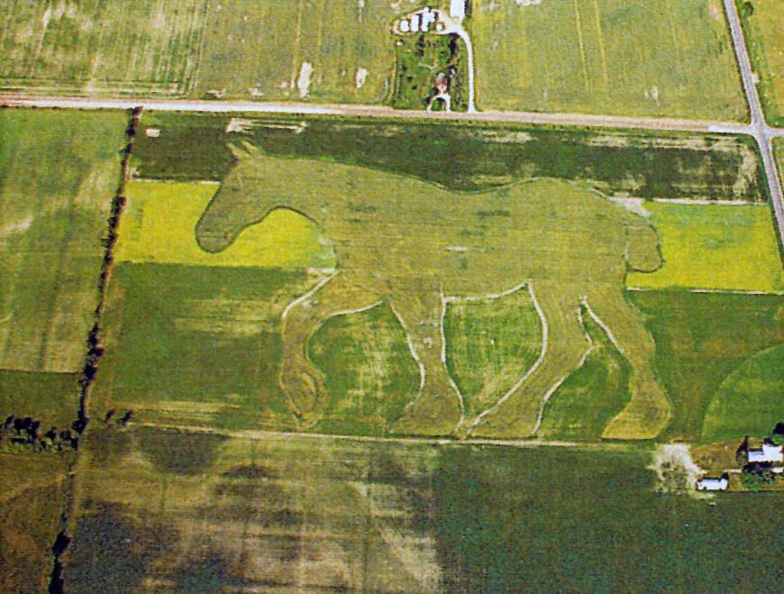
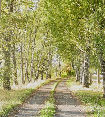
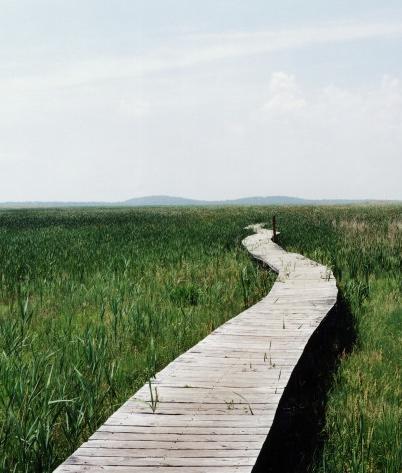
 West Dyke Trail Aerial")
2 Heritage The Terra Nova lands have a long history of human interaction with the land. The Musqueam First Nation provide the first evidence of human use of the area, probably for food gathering and use of waterways in the Terra Nova area as a means of transportation. The first non-native settlers arrived about 1868, and they sub-divided the land and worked both in the farming and fishing industries. Today the site contains evidence of many periods of past use during a variety of historical periods including: archaeological sites that contain evidence of First Nations use foundation remnants and pilings from the Terra Nova and Alliance canneries early houses and structures related to both agriculture and the fishing industry remnants of farm use including orchards, heritage trees, planted woodlots and fields hedgerows and fences delineating original property lines Terra Nova Cannery (Richmond Archives) Original Crown Grant of 8 Subdivisions (1890) These surviving heritage features are a living story book of the history of the Terra Nova lands. River Road Early homesteads were located close to the riverfront Gorden property (Don Gordon Papers) West Dyke Trail Aerial 1974 Gordon property (Don Gordon Papers) Westminster Highway Existing Homestead Building Existing Cannery Related Building Homestead Building Footprints Terra Nova 1915 Richmond Archives T E R R A N O V A N O R T H W E S T Q U A D R A N T P a r k P l a n O p e n H o u s e C i t y o f R i c h m o n d F e b r u a r y


3 Attachment 2 1. Heritage District Heritage Gardens Heritage Settlement Site Heritage Interpretive Features The Cannery Wharf Homestead Footprints: marking the locations Mellis Stage Line Thresholds Tracing old pathways Heritage Settlement: Mellis House Heritage Settlement: Cannery Store Bridges
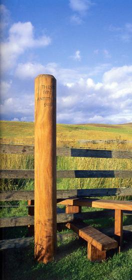
4 Heritage District This district refers predominately to the land that was settled along River Road and still contains five heritage listed buildings as well as remnants of the fishing industry. The intent is to preserve and interpret the rich story of the pioneer settlers, and the farming and fishing history of Terra Nova. Heritage Settlement Site The long term goal is to retain the five (5) settlers houses and establish creative adaptive reuses such as caretaker s suite, interpretive center, museum outreach programs, community meeting space, artist-inresidence workshop, exhibition space, or a concession stand. A minimum of two should be open for park uses while the others may find a P3 use to be financially sustainable, be rented out or stand as interpretive artefacts in the park. Grounds of the heritage houses will be restored to reflect the character of the original landscape. The intent is to balance heritage authenticity while protecting the wildlife values and features, specifically the heron rookery (which is located on the private property with the three heritage buildings). A management plan needs to developed and the approach taken will depend upon whether the City owns the group of five houses (assuming further acquisition) or only the two houses. Heritage Interpretive Features The goal is to provide interesting, subtle and creative interpretation and not inundate the park with too many signs. Included in the plan is the artistic creation of homestead footprints in the location of the original homesteads; bridges, benches, outlooks and thresholds that would contain simple interpretive elements and messages (these would occur throughout the park) and a recreation of the Mellis Terra Nova/Vancouver/ Eburne stage coach. The Cannery Wharf A raised boardwalk/deck will cross the water where the former BC Packers cannery was located. This will allow people to get out over the water, provide interpretation opportunities, and make a connection back to the upland heritage landscape. The former cannery store (the small white heritage building across the street) could potentially be used as a small concession stand.


5 2. Site Interpretation First Nations Interpretation Seasonal Environmental Art Ecology Centre / Outreach Facility Field Outlook Structure Save Terra Nova Interpretive Feature Field Outlook Seasonal Environmental Art Seasonal Environmental Art Ecology Centre / Outreach Facility
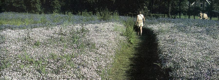
6 Site Interpretation Throughout the park there will a wide variety of features to encourage learning and discovery of the unique history and ecological features of the site in a creative manner. First Nations Interpretive Site An open interpretation structure and an interpretive trail will be developed adjacent to the historic slough. The theme and specific topics to be interpreted will depend upon the outcome of the archaeological research and fieldwork. Seasonal Environmental Art Fields Temporary and seasonal field patterns will be created through a sensitive use of plant material (grasses or crops). The field will remain fallow in winter and provide refuge for wildlife. The intent is to add interest and agricultural interpretation while retaining environmental values. Ecology Center/ Outreach Facility This is a potential adaptive reuse of the one of the City owned buildings (proposed at 2771 Westminster Highway) for Nature Park outreach programs, as meeting space for nature groups, and as a starting point for self guided interpretation tours. Field Outlook Structure An outlook structure will be constructed in the middle of the site to provide maximum 360 degree viewing. Bird blinds may be added to increase bird watching opportunities. Save Terra Nova Interpretive Feature The history and evolution of land uses in Terra Nova from the 1880 s to the present day park use is an interesting story. The intent is to sensitively show how economic and community values and decision making have evolved over the last hundred years.


7 3. Farm Centre Farm Management Centre Group Farming / Community Garden Plots Growing for community benefits Integrating community gardens into the park
8 Farm Centre The goal is to build upon the agricultural heritage of the site and modern urban needs by creating a central area where community based farming, community gardens, agricultural interpretation, and education about food sources could occur. One of the existing houses with auxiliary buildings along Westminster Highway would be adapted for reuse as part of this centre. Farm Management Centre The intent is to utilize existing buildings for maintenance equipment, agricultural education, and as a community meeting area. The proposed site for this center is 2771 Westminster Highway which would also be used as the Ecology Centre/ outreach program facility. This site has a number of buildings and landscape features such as an established hazelnut orchard and a beautiful manicured garden that will be retained and could be used for weddings or other events. Group Farming/Community Garden Plots A portion of the park will be designed to allow for community members, school groups, and potentially a non-profit organization group such as the Fruit Tree Project to maintain gardening plots. Food crops could be grown for educational and community benefits e.g. providing fresh produce for the Food Bank through initiatives such as Plant a Row - Grow a Row.


9 4. Wildlife Habitats Riparian Areas and Drainage Ditches Woodlots and Mature Trees Hedgerows Old-field Habitat Habitat and buffer - east side of park Birdwatching activities Woodlots Wetland Boardwalks Riparian Corridors Old Fields and Hedgerows
10 Wildlife Habitats The goal is to protect and enhance the biodiversity and habitat values of the site. Much of the existing environmental benefits of the land are a result of a century of farming and homestead landscapes that are now predominately fallow and naturalizing. The site is being enhanced to protect species with the greatest need, have restricted or threatened habitat requirements, whose habitats are well suited for this park (building upon existing features) and for breeding, overwintering and migratory birds. Riparian Areas and Drainage Ditches Water features provide an extremely rich habitat with food and nesting places for a wide variety of species. The heritage slough will be daylighted (reinstated) for interpretation opportunities and for enhancing the biodiversity of the site. Woodlots and Mature Trees Many of the existing trees are a result of landscaping around the original homesteads. These will be protected, enhanced and further planting will be introduced. These trees together with the adjacent oldfields provide important habitat for raptors (the blue heron and barn owl). The understorey plants in the woodlots provide one of the most diverse habitats for wildlife on the site. Hedgerows Hedgerows provide habitat and movement corridors for small animals and connect larger patches of habitat. Many of the existing hedgerows delineate the original property lines. These will be preserved, enhanced, interpreted and a new hedgerow will be added as a buffer on the east side of the site adjacent to the residential area. Old-field Habitats Farmland, predominately in the centre of the site, will be maintained and managed as fallow or old-field land for its habitat values for raptors. Preserving this type of habitat is of regional significance as open fields are rapidly being lost in the Lower Mainland.


11 5. Passive Open Space The intent is to have areas and features that allow for informal leisure use such as picnicking, children s play and a dogs off-leash area. This community use space is located on the west side of the site close to parking and includes features such as picnic tables, open grass areas for informal play, creative children s play facilities, new planting and washrooms. Rehabilitation will be undertaken in this area that contains remnants of concrete, garages and large patches of blackberries.
12 6. Park Infrastructure Turnarounds and Park Entry Trails Field and Riparian Boardwalks Parking
13 Park Infrastructure New elements such as trails and entry gates will be developed that allow people to move through the site and make the vehicular circulation more functional. A variety of trails will be constructed using existing laneways and paths as well as new boardwalks. Turnarounds and Park Entry Features These features include gates at Westminster Highway and River Road to control access to the site at night and turnarounds at the end of the roads and at the gate entrances. The security gates will be designed to ensure that the few residents on these roads can still control access to their homes when the park is closed at night. Trails The trail system will include existing lanes, farm pathways and new paths, follow along hedgerows, connect to the dyke trail, and be a mix of hard and soft surfaces. A major north-south boardwalk will be constructed that will link to the cannery wharf boardwalk; travel adjacent to the old-field habitat; and link to the Farm Centre and Terra Nova Natural Area. Interpretation and lookouts will occur along the boardwalk. Field and Riparian Boardwalks Boardwalks will be constructed over open fields to help create separation and over the historic slough and the wetland. Parking The parking has been reorganized and more spaces have been provided with opportunities in the plan for further additions as needed. The parking will be perpendicular to the River Road at the north and will be moved closer to the future community garden area along the south.


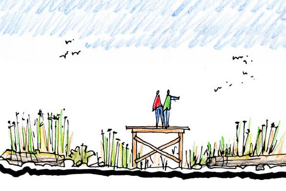
14 7. Dyke Perimeter Marsh Boardwalk Lookout Structure Heritage Slough Enhancement Dyke and Cannery buildings
15 Dyke Perimeter The waterfront is an important aspect of the site both historically and recreationally and is highly valued by the community. River Road and the trail system provide the main access and gateway to the site. The goal is to link the waterfront physically and through interpretation to the upland uses; maximize viewing opportunities; and enhance circulation. Marsh Boardwalk One boardwalk into the marsh is proposed at the north end adjacent to the lookout structure and decking. Further discussion is needed with the Department of Fisheries and Oceans to confirm the feasibility of this proposal. Lookout Structure This is located at a strategic spot that allows for maximum views of both the river and the marsh. Parking will be relocated and this area will be enhanced with a mounded grass sitting area, a dyke edge deck and boardwalk, and a two-storey observation structure. Heritage Slough Enhancement This involves connecting the heritage slough to the river with an irrigation flood gate, riparian improvements, and creating a boardwalk/bridge with interpretation over the water.
16 Attachment 3 Public Open Houses June 16th and 17th, 2004 Summary of Public Input The plan was presented with proposed features/land uses numbered and referenced to boards that described them in more detail. The public was asked to fill out a comment sheet and first rate the overall Vision and then rate the individual features from Like Very Much to Dislike or the option Don t Know. Results 22 out of the 25 land uses received 80% or better support, with only three receiving between 60% and 80% support (see below) Many of the respondents also commented that the planning team had listened to earlier comments at the first open houses and incorporated them into the Preferred Plan: Great job pulling all the material from the previous open house into a strong proposal. I think it is a superb conceptual use for the area. A big hurrah for the people involved! It makes me proud to live in Richmond. Very, very exciting, thanks for listening. It appears that the whole plan has been well thought out, and the proposal would have my full support. If I made a park it would be like this- good job. Comments that reflected concerns or cautionary notes included: Please no off-leash dog park Area too sensitive Tall trees will block views Ensure that there is minimal encroachment on the existing open spaces Very peaceful and quiet should stay that way Move garden plots/farming away from residential area Not asphalt except for some areas for wheelchair accessibility We don t need to manage and manipulate every blade of grass- we might just scare off the birds, wildlife etc. Summary of Ratings: *Note: All other proposed park uses not mentioned below had an approval rating above 96%. Land uses Percentage Liked Ecology Centre 96 % First Nations Interpretive Site 95% Turnaround/Park Entry 95% Marsh Boardwalk 94% Seasonal Mown Fields 92% Parking 92% Save Terra Nova Interpretive Feature 90% Farm Centre Buildings 88% Seasonal Environmental Art 78% Group Farming/Community Gardens 68% Dogs Off Leash Area 61%
17 Attachment 4 Land Ownership SHORT TERM NEGOTIABLE CONTRACT LIFE TENANT CITY OWNED LAND (WITHOUT TENANTS): INCLUDED IN PARK DESIGN CITY OWNED LAND (WITH TENANTS): INCLUDED IN PARK DESIGN (TYPE / DURATION OF TENANCY NOTED) PRIVATE UNDER NEGOTIATION TO ACQUIRE: INCLUDED IN PARK DESIGN PRIVATELY OWNED LAND: NOT INCLUDED IN PARK DESIGN
Terra Nova Rural Park Plan
 Terra Nova Rural Park Plan Part 1 Getting to know the land The Surrounding Area North Side Airport, River, Trail East Side - Residential West Side- Sturgeon Banks, West Dyke Trail South Side:Terra Nova
New Brighton Park Shoreline Habitat Restoration Project
 Vancouver Board of Parks and Recreation and Port Metro Vancouver New Brighton Park Shoreline Habitat Restoration Project Conceptual Design Public Consultation August 26 September 9, 2015 Discussion Paper
Call for Artists for: Design and Construction of Environmental Art Activation Story Mill Community Park, Bozeman, MT
 Call for Artists for: Design and Construction of Environmental Art Activation Story Mill Community Park, Bozeman, MT Seeking artists to design, fabricate and install art elements in the nature sanctuary
The Planning Partnership Baird + Associates TCI Management Consultants Ltd. Plan B Natural Heritage Wills Consulting Engineers Poulos & Chung Limited
 Little Lake Master Plan The Planning Partnership Baird + Associates TCI Management Consultants Ltd. Plan B Natural Heritage Wills Consulting Engineers Poulos & Chung Limited May 26, 2009 Purpose of Study
Minto-Brown Island. November 18, City of Salem, Parks & Transportation Services
 Minto-Brown Island Park Master Plan Public Meeting #1 November 18, 2014 City of Salem, Parks & Transportation Services Division, i i Public Works Welcome... and thanks for participating in the master planning
Chapter 5: Natural Resources and Environment
 NATURAL RESOURCES AND ENVIRONMENT 5-1 5 Chapter 5: Natural Resources and Environment BACKGROUND AND INTENT Urban expansion represents the greatest risk for the future degradation of existing natural areas,
Marshview Park. Concept Briefing and Feedback Session. Aquarium/Owls Creek Plan Steering Committee March 20, 2012
 Marshview Park Concept Briefing and Feedback Session Aquarium/Owls Creek Plan Steering Committee March 20, 2012 1 Outline of Today s Discussion Introductions Context for Marshview Park Site analysis -
Yarra Strategic Plan community engagement summary
 Yarra Strategic Plan community engagement summary Between May and August 2018 Melbourne Water undertook community engagement to build the content of the draft Yarra Strategic Plan. This engagement included
April 11, 2016 Park Board Chair and Commissioners General Manager Vancouver Board of Parks and Recreation New Brighton Salt Marsh - Preferred Concept
 TO: FROM: SUBJECT: April 11, 2016 Park Board Chair and Commissioners General Manager Vancouver Board of Parks and Recreation New Brighton Salt Marsh - Preferred Concept RECOMMENDATION A. THAT the Vancouver
WILLAMETTE FALLS LEGACY PROJECT
 OPPORTUNITIES & CONSTRAINTS There are here three falls on a line of rocks extending across the river, which forms the bed of the upper channel. The water is precipitated through deep abrazed gorges, and
1. Parks & Recreation Neighborhood Parks Community Parks Special Use Sites 2. Open Space 3. Trails
 Appendix A: Park Classifications The intent of parks and recreation classifications is to aid in making acquisition and design decisions for park sites, facilities and the organization of recreation space
ADDENDUM TO BIOLOGICAL SCOPING SURVEY REPORT, BOTANICAL SURVEY AND WETLAND DELINEATION
 ADDENDUM TO BIOLOGICAL SCOPING SURVEY REPORT, BOTANICAL SURVEY AND WETLAND DELINEATION FOR AVALON INN (APN 069-241-27 & -04) 1201 & 1211 NORTH MAIN STREET FORT BRAGG, CA MENDOCINO COUNTY prepared for:
3. VISION AND GOALS. Vision Statement. Goals, Objectives and Policies
 Vision Statement Queen Creek s interconnected network of parks, trails, open spaces and recreation opportunities provide safe and diverse activities and programs that sustain its unique, small town, equestrian
Wetland Design Manual. A1: Vision, core outcomes and aspirational outcomes
 Wetland Design Manual A1: Vision, core outcomes and aspirational outcomes Table of contents Introduction 5 Vision 6 Core outcomes 7 Effective pollutant removal and flow management... 7 Community safety...
University Park, Worcester Non Technical Summary December 2011
 University Park, Worcester Non Technical Summary December 2011 Introduction UW Wrenbridge LLP, a Joint Venture Company of the University of Worcester and Wrenbridge Land Ltd (the Applicants ) intend to
10.0 Open Space and Public Realm
 10.0 Open Space and Public Realm 10.0 Open Space and Public Realm The Public Open Space System is comprised of: outdoor spaces available for public use that are either publicly owned (e.g., parks and
PITKIN COUNTY AIRPORT LANDSCAPE MASTERPLAN
 WELCOMING VIEW OF AIRPORT CAMPUS AND AN IM- PORTANT SECTION OF THE EXPERIENCE INTO ASPEN. SOUTH MEADOW IS PART OF THE NATIVE GRASS, SAGE, AND WILDFLOWER MEADOW EXTENDING FROM BUTTERMILK MOUNTAIN DOWN TO
7. Biodiversity & Conservation Areas
 7. & Conservation Areas 7.1. Objectives The objectives of biodiversity and conservation areas are founded on the need to recognise the importance of biodiversity and acknowledge the need to protect, restore
(Exhibit A) Site Plan Adoption Detail and Support Information
 Site Plan Adoption Detail and Support Information") McCormick Park Master Site Plan (Exhibit A) Site Plan Adoption Detail and Support Information July, 2003 McCormick Park Site Plans.... 2-3 McCormick Park Site Plan Comparison... 4 Basic Assumptions about
McCormick Park Master Site Plan (Exhibit A) Site Plan Adoption Detail and Support Information July, 2003 McCormick Park Site Plans.... 2-3 McCormick Park Site Plan Comparison... 4 Basic Assumptions about
3. STATEMENTS OF DESIRED CHARACTER FOR PLANNING AREAS AND PRECINCTS
 3.30 Planning Area No. 30 Mary River Valley 3.30.1 Location and Role This Planning Area encompasses rural lands in the western part of the Shire. These lands are located within the catchment area of the
Master Plan Objectives and Policies
 Master Plan Objectives and Policies Introduction This chapter identifies the Park issues and recommended policies established by this Master Plan. The issues were identified through meetings with staff,
319 Grant: Baker Creek & Centenary Creek Restoration Initiative
 319 Grant: Baker Creek & Centenary Creek Restoration Initiative Objectives: Overview of Watershed Characteristics: Discussion of Project Tasks: Discussion of Watershed Management Plan: Presented by: Erich
Edgeley Pond + Park Public Meeting
 Edgeley Pond + Park Public Meeting February 21, 2017 Purpose of the meeting This Public Meeting is an opportunity for you to review the project background, process and provide input. City of Vaughan staff
McArthur Swamp Planning Unit. Fish, Plant, and Wildlife Habitat MCARTHUR SWAMP PLANNING UNIT
 McArthur Swamp Planning Unit Fish, Plant, and Wildlife Habitat Conduct surveys of the planning unit to identify biological resources and enable their protection. Most of the McArthur Swamp land acreage
Blue/Green Infrastructure Study Accomack County, VA
 Blue/Green Infrastructure Study Accomack County, VA Draft Asset Maps March 8-9, 2010 Green Infrastructure Center, Inc. 2 Overview What is Green and Blue Infrastructure Project Timeline & Tasks Literature
IV. Development in the Rural Overlay District
 Intracoastal Waterway Route 17 Route 168 Great Dismal Swamp VIRGINIA NORTH CAROLINA IV. Development in the Rural Overlay District IV-1 Route 17 in Chesapeake s Rural Overlay District affords distant views
Report to: Development Services Committee Report Date: April 24, 2017
 SUBJECT: Cornell Rouge National Urban Park Gateway - Report on Design Charrette and Next Steps PREPARED BY: Lilli Duoba, MES, MCIP, RPP, Manager, Natural Heritage (ext. 7925) REVIEWED BY: Marg Wouters,
Preliminary Sketch Plan for Fort Hunter Park
 Preliminary Sketch Plan for Fort Hunter Park Public Presentation November 19, 2009 Dauphin County Parks and Recreation 100 Fort Hunter Road Harrisburg, PA 17110 (717) 599-5188 www.dauphinc.org THOMAS COMITTA
Once Upon a Gravel Pit: Reconnecting Floodplain through Aggregate Extraction
 Once Upon a Gravel Pit: Reconnecting Floodplain through Aggregate Extraction 5 th International Conference on Natural Channel Systems September 26, 2016 1 The Story of Snyder s Flats Historical influences
Regional Context Statement
 Regional Context Statement REGIONAL CONTEXT STATEMENT 3. REGIONAL CONTEXT STATEMENT In 1995, the Provincial Government passed into law the Growth Strategies Act. The purpose of this provincial initiative
PORT OF VANCOUVER WATERFRONT DEVELOPMENT. Concept Development Plan City Center Redevelopment Authority April 20, 2017
 PORT OF VANCOUVER WATERFRONT DEVELOPMENT Concept Development Plan City Center Redevelopment Authority April 20, 2017 Port History PORT ESTABLISHED 1912 TERMINAL 1 ACQUIRED 1925 GWM SIGNS LEASE 1935 HARBOR
CHARLES COUNTY GOVERNMENT RFP NO POPES CREEK RAIL TRAIL DESIGN
 CHARLES COUNTY GOVERNMENT Department of Fiscal and Administrative Services Purchasing Division Telephone: 301-645-0656 July 7, 2015 RFP NO. 16-02 POPES CREEK RAIL TRAIL DESIGN ADDENDUM NUMBER ONE TO: All
CORPORATE REPORT. NO: R137 COUNCIL DATE: June 29, 2015 REGULAR COUNCIL. TO: Mayor & Council DATE: June 24, 2015
 CORPORATE REPORT NO: R137 COUNCIL DATE: June 29, 2015 REGULAR COUNCIL TO: Mayor & Council DATE: June 24, 2015 FROM: General Manager, Parks, Recreation and Culture FILE: 4100-01 SUBJECT: Surrey Centre Cemetery
CITIZEN S ADVISORY COMMITTEE PUBLIC REALM CONCEPT PRESENTATION. October 25, 2018
 CITIZEN S ADVISORY COMMITTEE PUBLIC REALM CONCEPT PRESENTATION October 25, 2018 AGENDA Placemaking Study Overview Public Space Design Character and Concepts / Updated Visuals PLACEMAKING STUDY OVERVIEW
A Joined-up Regional Landscape: A Roadmap to connect the parts
 Breaking the Barriers: Engineering Solutions to Ecological Problems A Joined-up Regional Landscape: A Roadmap to connect the parts Associate Professor Darryl Low Choy Urban Research Program Outline Nature
City of Iowa City Department of Neighborhood and Development Services Department of Parks and Recreation Department of Public Works City Manager s
 RFP Pre-submittal meeting December 18, 2015 City of Iowa City Department of Neighborhood and Development Services Department of Parks and Recreation Department of Public Works City Manager s Office Background
UNIVERSITY TOWN NEIGHBOURHOODS 5.2 ECO-CORRIDOR MELBOURNE CAMPUS MASTER PLAN 2014
 5.2 ECO-CORRIDOR 37 ECO-CORRIDOR EXISTING CONDITIONS & VISION NEIGHBOURHOOD VISION Investment in the Eco-corridor Neighbourhood will signify the University s commitment to supporting local ecology and
AMENDMENT NO. 30 TO THE OFFICIAL PLAN OF THE TOWN OF MILTON
 AMENDMENT NO. 30 TO THE OFFICIAL PLAN OF THE TOWN OF MILTON Subject: Boyne Survey Secondary Plan and Related Official Plan Amendments The following text and schedules constitute Amendment No. 30 to the
Woodland Conservation and the Master Plan
 1 WHAT IS A MASTER PLAN? A Vision for the Future of Your Community Woodland Conservation and the Master Plan Goals Objectives Strategies 2 How Will Your Community Look? TREE PRESERVATION AND THE MASTER
Welcome! HORSESHOE BAY PARK. Welcome!
 Welcome! HORSESHOE BAY PARK Welcome! Where are we in the process? Today we would like your input on how Horseshoe Bay Park can be upgraded to serve the community s needs better. CONSULT STAKEHOLDERS TAKE
Draft Stillwater 2030 Comprehensive Plan- Goals and Policies
 Draft Stillwater 2030 Comprehensive Plan- Goals and Policies Instructions- Review each goal and policy and discuss with group any changes, deletions for additions to the list using your groups pen. Keep
WELCOME GYPSY LANE. Wider Site Location plan. Proposals for the development of LAND OFF FOXLYDIATE LANE WEBHEATH. Proposals for the development of
 WELCOME The developers are preparing an outline planning application for a residential led development and need the community s views in order to develop the proposals further WHAT IS PROPOSED? A high
Policy & Procedure Effective Date: Parks Department Page of
 City of Arvada Policy & Procedure Effective Date: Parks Department Page of TITLE: City of Arvada Prairie Dog Habitat Plan APPROVAL: PURPOSE: To establish a plan for the preservation of black-tailed prairie
Smart Growth Development Checklist
 2004 Smart Growth Development Checklist Smart Growth Development Checklist Corporation of the City of New Westminster Guide and manage growth in a manner which is consistent with the principles of sustainable
The scope of the plan will focus on the Prospect Heights Slough and Hillcrest Lake as one entity.
 Plan for Prospect Heights Natural Resources Commission Plan for Improved Public Access and Enjoyment of the Prospect Heights Slough and Hillcrest Lake July 23, 2018 The City Council has requested the Natural
Stormwater Standards. Clackamas County Service District No. 1. Planting Guide for Buffers
 Stormwater Standards Clackamas County Service District No. 1 APPENDIX B Planting Guide for Buffers Table of Contents Appendix B - Planting Guide for Buffers... Page B.1 General... 1 B.1.1 Introduction...
Design Specifications & Requirements Manual
 11 PARKS & OPEN SPACES 11.1 DEFINITIONS... 1 11.1.1 Neighbourhood Parks... 1 11.1.2 District Parks... 1 11.1.3. Sport Parks... 1 11.1.4 Urban Parks... 1 11.1.5 Civic Spaces... 1 11.1.6 Open Space System...
NORTHEAST RIVER CROSSING FUNCTIONAL PLANNING STUDY
 WELCOME Northeast River Crossing Functional Planning Study Phase 2 Public Meeting 4 to 8 PM Informal drop-in format and discussion tables Meeting Purpose Introduce the Northeast River Crossing Functional
8.0 Design and Form of Development 43/
 42/ 8.0 Design and Form of Development 43/ Rothwells Farm, Golborne/ Development Statement Figure 7. Site Constraints Key 44/ Site Boundary 360 Bus Route/Stops Existing Trees Underground Water Pipe Sensitive
The Illinois Department of Transportation and Lake County Division of Transportation. Route 173, including the Millburn Bypass
 The Illinois Department of Transportation and Lake County Division of Transportation welcome you to this Public Hearing for U.S. Route 45 from Illinois Route 132 to Illinois Route 173, including the Millburn
Queensborough Eastern Neighbourhood Node. Community Open House
 Queensborough Eastern Community Open House The Vision The Queensborough Eastern will become the heart of eastern Queensborough. Through a sensitive mix of viable commercial and residential areas, the neighbourhood
Welcome to our public exhibition
 About our development Welcome to our public exhibition This exhibition gives you the chance to view and comment on our proposals for a new residential development of 165 high-quality homes, along with
Chapter 6. Overall Vision RECOMMENDATIONS. More Trail and Trail. Connections. Equal Access to Park. Facilities and Programs. Water Access.
 Overall Vision More Trail and Trail Connections Equal Access to Park Facilities and Programs Water Access Environment Variety Chapter 6 RECOMMENDATIONS Chapter 6 The following recommendations for park,
A REGIONAL HERITAGE STRATEGIC PLAN for OKANAGAN - SIMILKAMEEN
 A REGIONAL HERITAGE STRATEGIC PLAN for OKANAGAN - SIMILKAMEEN The Regional District of Okanagan-Similkameen is preparing a Regional Heritage Strategic Plan. The Strategic Plan will identify important themes
Board Members Vancouver Park Board General Manager Parks and Recreation
 TO: FROM: SUBJECT: Board Members Vancouver Park Board General Manager Parks and Recreation Date: February 6, 2014 Proposed Community Garden at Creekside Community Centre RECOMMENDATION THAT the Board support
More than 30 adults and 19 children were involved in these community workshops.
 Linwood Workshops held at Household of Faith Deliverance Church 3.29.08 and 4.05.08 What is a Design Workshop? We use the term workshop (often called charrette among design professionals) to describe a
ILLUSTRATIVE MASTERPLAN
 ILLUSTRATIVE MASTERPLAN The Development Dairy Crest (Imperial College) The Proposed Development aims to create a new high quality residential neighbourhood, alongside a new public park for White City.
Billington Parish Green Infrastructure Plan
 Billington Billington Parish Green Infrastructure Plan Methodology Following a presentation to the Annual Parish Meeting, The Greensand Trust was invited to attend the next Parish Council Meeting. The
PURPOSE AND NEED FOR ACTION PUBLIC SCOPING LETTER SILVER GLEN SPRINGS RECREATION ENHANCEMENT PROJECT. Ocala National Forest
 File Code: 1950/2300/2720 PUBLIC SCOPING LETTER SILVER GLEN SPRINGS RECREATION ENHANCEMENT PROJECT Lake George Ranger District Marion County, Dear Visitor: The of the has developed a proposal (Proposed
Neighbourhood Planning Local Green Spaces
 Neighbourhood Planning Local Green Spaces Introduction... 2 1. Why green space is important... 4 2. Neighbourhood plans and green space... 6 3. Evidence... 8 Statutory designations... 9 Green space audit...
The following principles guide the development of goals and strategies to protect and promote these amenities:
 OPEN SPACE/PARKS/TRAILS/RECREATION GOALS/STRATEGIES Cherry Hills Village is a living environment that offers low density development, open areas, public scenic vistas, public trails and public parks. This
NON-TECHNICAL SUMMARY
 Proposed Sand and Gravel Extraction and Associated Processing Operations with Restoration to a Mixture of Agriculture and Nature Conservation including Areas of Shallow Water at Hedgeley, Northumberland
BRADENTON RIVERWALK EXPANSION MASTER PLAN
 BRADENTON RIVERWALK EXPANSION MASTER PLAN INTRODUCTION & AGENDA Process Update Community Engagement Summary Center for Active Design (CfAD) Recommendations Context and Existing Conditions Master Plan Alternatives
HUMBER BAY PARK PROJECT - BUILDING CONCEPT
 WELCOME 1 Humber Bay Park, with its system of trails, rugged shoreline, and dramatic views, is a unique and rare waterfront experience within the larger metropolitan Toronto area offering a place for quiet,
DEVELOPMENT PERMIT SENSITIVE ECOSYSTEMS
 DEVELOPMENT PERMIT SENSITIVE ECOSYSTEMS What is the Sensitive Ecosystem Development Permit Area (SEDPA)? Surrey s SEDPA is made up of two distinct classifications of the natural environment: Streamside
ARCADIAN THAMES WALKS
 Thames Landcape Strategy Hampton to Kew Annual Review 2008 15 ARCADIAN THAMES WALKS Below is one of the TLS Arcadian Thames Walks that will lead you around the fascinating River Thames on your doorstep.
Rural Conservation. Rural Conservation. Moving Forward ~ Planning Ahead. Introduction
 Introduction Minnehaha County expresses at least two very different styles of character. The City of Sioux Falls provides a strong urban atmosphere because of its size and regional status, and the unincorporated
RIVERFRONT REDEVELOPMENT PLAN
 RIVERFRONT REDEVELOPMENT PLAN PROJECT BACKGROUND DEVELOPMENT OPPORTUNITIES This project strives to connect St. Francisville s downtown Historic District to the Mississippi River through river tourism,
Olympics. Large areas of the Lower Lea Valley have now been taken for the Olympics and surrounded by tall blue fences.
 Olympics December 2007 Update. Large areas of the Lower Lea Valley have now been taken for the Olympics and surrounded by tall blue fences. White Hart Field and small pockets of open space along Waterden
Las Colonias Park Master Plan
 2013 Las Colonias Park Master Plan City of Grand Junction June 2013 Introduction Las Colonias Park, a 101 acre parcel on the edge of the Colorado River south of downtown, was deeded to the City of Grand
Planning for Staten. Habitat Restoration and Green Infrastructure. Island s North Shore
 Habitat Restoration and Green Infrastructure Planning for Staten Island s North Shore Community Board 1 March 1, 2018 NYC Parks Forestry, Horticulture, and Natural Resources Funded by the NYS Department
Meridian Water Phase 1 Application
 Meridian Water Phase 1 Application MW11 Environmental Statement Non-Technical Summary London Borough of Enfield March 2016 Contents 1 Introduction 1 2 The proposed development 2 3 Evolution of the proposed
Yadkin River Greenway Feasibility Study Fact Sheet Village of Clemmons, Town of Lewisville, Town of Bermuda Run
 Fact Sheet Village of Clemmons, Town of Lewisville, Town of Bermuda Run Project Background The Yadkin River Greenway Feasibility Study is a joint project with the Village of Clemmons, the Town of Bermuda
Keystone Business Park Precinct Structure Plan North East Industrial Precinct. Part 2 Design Principles
 Keystone Business Park Precinct Structure Plan North East Industrial Precinct Part 2 Design Principles Context Issues Services Landform Issues Geotech and contamination Ecology Traffic and access Issues
Wisconsin downtown action council Downtown project case study profile
 Wisconsin downtown action council Downtown project case study profile Project Name Onalaska Waterfront Project Location City of Onalaska Project Type (check all that apply) g Residential g Commercial g
Green System Planning Day 4 SALA Vancouver Summer Program
 Green System Planning Day 4 SALA Vancouver Summer Program OUTLINE 1. Lecture 1 Green Networks Cynthia Girling 2. Break 3. Lecture 2 Principles of Park Planning Jeff Fitzpatrick 4. Photo of the Day assignment
Britannia Farm Master Plan Refresh September 21 st 2016 Public Consultation #2 Summary Report
 Britannia Farm Master Plan Refresh September 21 st 2016 Public Consultation #2 Summary Report September 21 st Public Open House #2 Overview The Peel District School Board is undertaking a Refresh of the
Summary of Changes in the DRAFT Rivers Project Natural Resource Master Plan from the 2001 approved plan to 2014 plan
 Summary of Changes in the DRAFT Rivers Project Natural Resource Master Plan from the 2001 approved plan to 2014 plan The entire Master Plan format and layout has been changed to comply with regulation
Greenways as an alternative to traditional infrastructure. Green Infrastructure
 Greenways as an alternative to traditional infrastructure Green Infrastructure What is a Greenway? Little (1990) - A linear open space along a natural or human made corridor. Fabos - linked corridors nature
Eastcreek Farm. Planned Development Standards September, 2014
 Eastcreek Farm Planned Development Standards September, 2014 ekfarm Contents 01. General Standards 02. Residential Development Standards 03. Architectural Design Standards 04. Landscape Design Standards
Burrowing Owl Habitat Project at the Albany Plateau. (a component project of the Gilman Street Playing Fields Project City of Berkeley) March 10, 2006
 March 10, 2006") Burrowing Owl Habitat Project at the Albany Plateau (a component project of the Gilman Street Playing Fields Project City of Berkeley) March 10, 2006 Submitted by The City of Berkeley Project history During
Burrowing Owl Habitat Project at the Albany Plateau (a component project of the Gilman Street Playing Fields Project City of Berkeley) March 10, 2006 Submitted by The City of Berkeley Project history During
HERITAGE INTERPRETIVE PLAN
 Photo credit: City of Edmonton Archives, EA-160-165 EXECUTIVE SUMMARY HERITAGE INTERPRETIVE PLAN river crossing i THE A L E 101A S T 102 S T EDMONTON BALLPARK 100 S T S T ROSS FLATS APARTMENTS 100A S T
01 Welcome. Why are we here?
 01 Welcome Why are we here? In July 2014 GreenSquare unveiled its plans for 1500 homes to the local community providing much needed houses during the first half of the Stroud District Local Plan period.
City of Surrey Ecosystem Management Study. Integration of ecological processes with land use
 City of Surrey Ecosystem Management Study Integration of ecological processes with land use Natural areas in Surrey are changing as the City grows and evolves. Many important natural areas remain or may
FORMER CANADIAN FORCES BASE (CFB) ROCKCLIFFE SECONDARY PLAN. Official Plan Amendment XX to the Official Plan for the City of Ottawa
 ROCKCLIFFE SECONDARY PLAN. Official Plan Amendment XX to the Official Plan for the City of Ottawa") FORMER CANADIAN FORCES BASE (CFB) ROCKCLIFFE SECONDARY PLAN Official Plan Amendment XX to the Official Plan for the City of Ottawa 1 INDEX THE STATEMENT OF COMPONENTS PART A THE PREAMBLE PAGE Purpose...
FORMER CANADIAN FORCES BASE (CFB) ROCKCLIFFE SECONDARY PLAN Official Plan Amendment XX to the Official Plan for the City of Ottawa 1 INDEX THE STATEMENT OF COMPONENTS PART A THE PREAMBLE PAGE Purpose...
Coquitlam River Riparian Planting
 Coquitlam River Riparian Planting Year Four Year Four Report, March 2016 Prepared for: Fish and Wildlife Compensation Program Prepared by: Watershed Watch Salmon Society and the Kwikwetlem First Nation
MAYFIELD WEST SECONDARY PLAN PHASE 2
 MAYFIELD WEST SECONDARY PLAN PHASE 2 Public Open House #3 February 25, 2010 Draft Preferred Land Use Scenario TOWN OF CALEDON PLANNING & DEVELOPMENT DEPARTMENT Open House Agenda TOWN OF CALEDON 1. Welcome
1.0 INTRODUCTION. Brantham Industrial Area Regeneration - Factory Lane - Brantham
 1.0 INTRODUCTION Welcome to this exhibition of our proposals for the regeneration of the Brantham Industrial Area located off Factory Lane in Brantham. This presentation will give you an opportunity to
Welcome. Welcome to our first Open Day event
 Welcome We are here Welcome to our first Open Day event About us This is the first of many opportunities to have your say on the development of the. Urban&Civic was founded specifically to enable and deliver
Kenilworth Station Art and Landscape Committee (KSALC) June 25, 2015
 June 25, 2015") Kenilworth Station Art and Landscape Committee (KSALC) June 25, 2015 1 Today s Topics Welcome and Introductions Appoint Committee Co-Chairs Summary of Community Workshop #1 Kenilworth Channel Bridge Design
Kenilworth Station Art and Landscape Committee (KSALC) June 25, 2015 1 Today s Topics Welcome and Introductions Appoint Committee Co-Chairs Summary of Community Workshop #1 Kenilworth Channel Bridge Design
Community Conservation Workshop. Lake Placid
 Community Conservation Workshop Lake Placid 2 Community Conservation Program Welcome! We have designed a Community Conservation Program that listens to the needs of community members. We are conducting
1.0 Background. 1.1 Study Process
 1.0 Background Planning for Terwillegar Park began in 2005 with the preparation of A Vision for Terwillegar Park (Randall Conrad & Associates), a City wide public consultation and visioning exercise. The
Background Information
 Background Information view at site entrance THE LONDON BOROUGH OF SUTTON As the strategic local authority the Council is working with a range of partners to take forward various development sites in Hackbridge.
The Vision. Photo provided by The Minervini Group. 46 Vision, Objectives & Strategies
 Vision, Objectives & Strategies The is the public framework and guide for future development of the Grand Traverse Commons. The establishes public polices for infrastructure, the preservation of natural
CANADA 150 SPECIAL EDITION Evaluation Form 2017
 CANADA 150 SPECIAL EDITION Evaluation Form 17 2 P age 17 - Canada 150 Special Edition - Evaluation Form Community: Province: Category: The evaluation is based on 8 criteria, divided into the following
Mississauga Waterfront. Parks Strategy - Draft
 Potential configuration for river s edge seating. Boating on Credit River: A regatta Boating on Credit River: Active enjoyment 5.2 Port Credit Memorial Park West Priority Park 5.2.1 Site Opportunities
Gloucester County s Comprehensive Plan. The Community Connection
 Gloucester County s Comprehensive Plan The Community Connection Current Comp Plan Adopted in 1991 with a 20 year planning horizon Updated in 1995 with Part V- Implementation Recommendations and Appendix
Surrey Ecosystem Management Study
 Surrey Ecosystem Management Study Green Infrastructure Network Opportunities Public Open House & Information Session June 24 th, 2010 EMS Process Ecological Inventory Ecological Assessment Management Policy
BAY DRIVE PARK Questions and Answers
 Q. How tall is the building near the beach and what will it look like? A. The Park Amenity Building is a two-story metal-roofed coquina-faced building with a restroom on the first floor and an observation
Social Fertilizer. Participatory Planning. Abstract. Table of Contents. Learning from Terra Nova Park Richmond, BC. of Community Gardens
 Social Fertilizer Participatory Planning of Community Gardens Learning from Terra Nova Park Richmond, BC CASE IN POINT 2008 Abstract The future of city planning is rooted within participatory practice.