Section 4(f) De minimis Impact Documentation
|
|
|
- Kory Morton
- 5 years ago
- Views:
Transcription
1 1. Project Description Section 4(f) De minimis Impact Documentation Wadsworth Road at Kilbourne Road Section No ES Lake County Forest Preserve District Lake County, Illinois a. Project Number: P (Lake County Division of Transportation lead) b. Project Name: Wadsworth Road at Kilbourne Road c. Location: Lake County d. Project Type: Roadway widening and sidewalk e. Project Length: 0.34 miles f. NEPA Class of Action: Federal Approved Categorical Exclusion g. Purpose and Need of the Project: The purpose of the project is to provide an improved transportation system to address safety, mobility, and operational deficiencies, as well as filling in a gap in the non-motorized network. h. Project Status: Phase I Engineering and Environmental Studies are nearing completion with a Public Information Meeting held on April 19, 2017 and Design Approval anticipated early summer Section 4(f) Resource a. Name of Resource: Wadsworth Savanna Forest Preserve b. Type of Resource: Forest preserve c. Official with Jurisdiction (OWJ): Lake County Forest Preserve District (LCFPD) d. Description of role/significance in the community: Prior to purchase by the LCFPD, the land on which the Wadsworth Savanna Forest Preserve is located was previously farmed land. Currently there are no existing recreational facilities on this property and there are no future plans to implement recreational facilities on this property. The LCFPD preserves this previously farmed land with the goal of returning to its natural state.
2 3. Description of Intended Section 4(f) Resource Use a. Type and Acres of Impact: Wadsworth Savanna Forest Preserve: 0.11 acres i. Fee Simple Acquisition (FSA): 0.02 acres for northwest corner intersection improvements at Wadsworth Road and Kilbourne Road. ii. Temporary Easement: 0.09 acres for Kilbourne Road widening and grading. b. Existing Function of Impacted Acres: The impacted area is located northwest of the Wadsworth Road and Kilbourne Road intersection adjacent to both roadways. Currently, there are no recreational facilities within and adjacent to the impacted area. LCFPD stated that currently there are no planned or programmed improvements to this holding and that there would be no major impacts to their property with the proposed improvement. The LCFPD preserves the impacted area with the goal of returning to its natural state. There will be no adverse impact to the Wadsworth Savanna Forest Preserve s function or use based on this acquisition. 4. Description of Efforts to Avoid, Minimize, and Mitigate/Enhance the Resource a. Avoidance and minimization efforts made and benefits to resource: The Wadsworth Savanna Forest Preserve is adjacent to both Wadsworth Road and Kilbourne Road. Roadway widening is required to provide the southbound right turn lane to meet the project purpose and need. Shifting the alignment east to avoid the Wadsworth Savanna Forest Preserve could not be performed because the shift would increase impacts to residential properties located east of Kilbourne Road. b. Commitments for mitigation or enhancement: The proposed design does not show any pedestrian crossing of Wadsworth Road because the Village of Wadsworth does not have any plans for improved pedestrian facilities along Kilbourne Road. Along with the intersection improvement, a sidewalk is proposed along the south side of Wadsworth Road from Cashmore Road to Kilbourne Road, which connects to existing pedestrian facilities on both sides of Wadsworth Road between Chicago Avenue and the Canadian Pacific at-grade railroad crossing to the west. The proposed sidewalk will be under the jurisdiction and maintenance responsibility of the Village of Wadsworth and LCFPD is in support of the sidewalk improvement, which helps provide connectivity between the Waukegan Savanna Forest Preserve and the Des Plaines River canoe launch which is 0.80 miles west of the Wadsworth Road at Kilbourne Road project area.
3 5. Evidence of Opportunity for Public Review and Comment: a. Type of public availability: A Public Information Meeting was held on April 19, 2017 at the St. Mark s Lutheran Church from 5:00 to 7:00 p.m. The Public Information Meeting was advertised in the Lake County News - Sun on April 4, 2017 and April 12, 2017, on the project website, on the LCDOT website, Facebook, and Twitter feed. Invitation letters were mailed to all residents and business adjacent to the proposed roadway improvements, as well as local, state and federal agencies, and elected officials. Variable message boards were placed near the corridor to advertise the Public Information Meeting. Exhibits were displayed during the hearing that highlighted the areas for which Section 4(f) coordination is required. The Section 4(f) documentation was available at LCDOT (600 W. Winchester Rd, Libertyville, IL 60048), at the LCFPD (1899 W. Winchester Rd, Libertyville, IL 60048), and posted on the Wadsworth Road at Kilbourne Road project website from April 19, 2017 through May 10, b. The public meeting and Section 4(f) comment period was from April 19, 2017 through May 10, Evidence of Coordination with Official(s) with Jurisdiction a. April 17, 2014: Summary of LCFPD Coordination Meeting #1 b. April 14, 2015: Summary of LCFPD Coordination Meeting #2 c. December 4, 2015: Summary of LCFPD Coordination Meeting #3 d. February 24, 2016: correspondence from LCFPD to LCDOT with preferences to Kilbourne Road finalist intersection alternatives e. May 19, 2016: Project Information Meeting #2 invitation to adjacent property owners f. July 12, 2016 Summary of meeting with FHWA discussion pursuing de minimis finding for the Lake County Forest Preserve District property g. July 26, 2016: correspondence with LCFPD with comments to Kilbourne Road finalist intersection alternatives h. November 9, 2016 Summary of LCFPD Coordination Meeting #4 7. Supporting Documentation a. Section 4(f) Impact Exhibit b. Project Location Map c. Aerial View Wadsworth Savanna Forest Preserve d. Coordination e. Roadway Plan and Profile Sheet f. Drainage Plan and Profile Sheet
4 Attachment A Section 4(f) Impact Exhibit


5 Legend PROPOSED ROW ACQUISITION PROPOSED TEMPORARY EASEMENT ACQUISITION EXISTING ROW PROPOSED ROW PROPOSED TEMPORARY EASEMENT I Feet 1 inch = 40 feet Lake County Forest Preserve District Wadsworth Savanna Forest Preserve Temporary Easement Impact = 0.09 Ac 10' Kilbourne Rd Proposed R.O.W. Impact = 0.02 Ac Wadsworth Rd Path: N:\LCDOT\130445\GIS\Exhibits\PROPOSED IMPROVEMENTS.mxd CLIENT: TITLE: WADSWORTH ROAD AT KILBOURNE ROAD INTERSECTION IMPROVEMENT LAKE COUNTY FOREST PRESERVE DISTRICT EXHIBIT DSGN. DWN. CHKD. FILE: SCALE: 1:0 AUTHOR: MHAYES PLOT DATE: 3/14/2017 PROPOSED IMPROVEMENTS PROJ. NO. DATE: /20/2017 SHEET 1 OF 1 DRAWING NO. ATTACHMENT A
6 Attachment B Project Location Map


 CLIENT: TITLE: PROJ. NO.")

7 I0 1,000 2,000 4,000 Feet 1 inch = 2,000 feet Wadsworth Savanna Forest Preserve PROJECT LOCATION Path: N:\LCDOT\130445\GIS\Exhibits\LocationMap Wadsworth at Kilbourne.mxd (c) OpenStreetMap and contributors, Creative Commons-Share Alike License (CC-BY-SA) CLIENT: TITLE: PROJ. NO WADSWORTH ROAD AT KILBOURNE ROAD LOCATION MAP DSGN. DWN. CHKD. FILE NAME: SCALE: 1 "= 2,000 ' USER: mhayes PLOT DATE: 3/14/2017 LocationMap Wadsworth at Kilbourne DATE: SHEET 1 OF 1 DRAWING NO. 6/23/2015 ATTACHMENT B
8 Attachment C Aerial View Wadsworth Savanna Forest Preserve


, 1:1,200-Scale (1 inch = 100 feet) Tiled 4-band (R, G, B, NIR) Digital Orthoimagery for Cook, DuPage, Grundy, Kane, Kendall, Lake,")

9 I0 1,000 2,000 4,000 Feet 1 inch = 2,000 feet IL ROUTE 173 W IL ROUTE 173 W 21ST ST IL ROUTE 173 W 21ST ST W 21ST ST TRI STATE TOLLWAY I-94 N MILL CREEK RD W REED CT N SKOKIE HWY SEDGE W KELLY RD PLAZA LN GOLDEN ROD N CT N DILLEYS RD N US HIGHWAY 41 LN ORCHARD BLUFF LN N US N SKOKIE HWY HIGHWAY 41 Wadsworth Savanna Forest Preserve W KAISER RD W W KAZMER RD CONCORD CT N KILBOURNE RD W ANDOVER RD WWALDEN LN W JODY LN W DEER CREEK LN N DELANY RD W AUGUST ZUPEC DR W OAK KNOLL RD Path: N:\LCDOT\130445\GIS\Exhibits\Wadsworth Savanna Forest Preserve.mxd I-94 I-94 I-94 Service Layer Credits: Cook County 2015 Aerial Imagery (Contract No ), 1:1,200-Scale (1 inch = 100 feet) Tiled 4-band (R, G, B, NIR) Digital Orthoimagery for Cook, DuPage, Grundy, Kane, Kendall, Lake, McHenry, and Will US HIGHWAY 41 W WADSWORTH RD PROJECT LOCATION CLIENT: TITLE: PROJ. NO DSGN. DWN. CHKD. FILE NAME: N CHICAGO AVE N OAKCREST WADSWORTH SAVANNA FOREST PRESERVE SCALE: N USER: mhayes PLOT DATE: 3/14/2017 Wadsworth Savanna Forest Preserve L 1 "= 2,000 ' N BURR OAK LN DATE: N DELANY RD SHEET 1 OF 1 DRAWING NO. 6/23/2015 ATTACHMENT C
10 Attachment D Coordination
11 MEETING SUMMARY Meeting Date: April 17, 2014 Location: Project: Lake County Division of Transportation Wadsworth Road Intersection Improvements Purpose: LCSMC & LCFPD Coordination Meeting #1 Attendees Representing Emily Karry LCDOT Darrell Kuntz LCDOT Randy Seebach LCFPD John Nelson LCFPD Glenn Westman LCSMC Bob Gardiner LCSMC Mike Matkovic CBBEL Matt Huffman CBBEL A coordination meeting was held at the Lake County Division of Transportation on April 17, 2014 for the Wadsworth Road at Dilleys Road, U.S. Route 41, and Kilbourne Road intersection improvement project. An agenda was distributed and an aerial GIS exhibit was displayed for discussion purposes. Introductions were made and an explanation of the project team was made with Christopher B. Burke Engineering (CBBEL) as the lead consultant for Lake County Division of Transportation (LCDOT). Darrell Kuntz is the project manager for Lake County Division of Transportation with Matt Huffman the project manager for CBBEL. The general project scope was discussed, which includes intersection improvements to Dilleys Road at Wadsworth Road, U.S. Route 41 at Wadsworth Road, and Kilbourne Road at Wadsworth Road. The project will include topographic survey to cover the section of Wadsworth Road from the east I-94 bridge abutment to the west Des Plaines River bridge abutment as well as from Cashmore Road to the west leg of the Delany Road intersection, which allows the possibility of including improvements to Wadsworth Road that meet the limits of prior projects within the corridor (I-94 to Delany Road). LCDOT will make a decision of the improvement limits as the project progresses through the project development process and as a preferred alternative is selected. This project is being developed through the Federal Project Development process to make the project eligible for future federal funds. To date no federal funds have been obtained for this project. LCDOT initiated this project in February 2014 and CBBEL has begun data collection for the project, which includes initial meetings with the Village of Wadsworth, Newport Township, Lake County
12 Wadsworth Road Coordination Meeting 4/17/2014 Page 2 Forest Preserve District (LCFPD), and Lake County Stormwater Management Commission (LCSMC). Traffic counts have been completed and coordination with Chicago Metropolitan Agency for Planning (CMAP) is forthcoming. Topographic survey is anticipated to begin in early May. CBBEL will coordinate with LCFPD to obtain proper access permission. Environmental field surveys will also occur around this time to delineate wetlands and Waters of the U.S. Subsequently, coordination will occur with LCSMC to verify and review the wetland delineations. Trees will not be tagged during the tree identification and survey process. LCFPD provided several plans including the Conceptual Master Plan for Waukegan Savanna Forest Preserve as well as the Master Plan Regional Trail Connections for the Waukegan Savanna Forest Preserve. It was stated that the proposed regional trail location was changed from Wadsworth Road to IL Route 173. LCFPD would like to see a sidewalk or bike path facility constructed along the south side of Wadsworth Road from Waukegan Savanna Forest Preserve to the west, however they did not express interest in being a cost participating local agency at this time. Recently a sidewalk was added along the south side of Wadsworth Road from the Canoe Launch at the Des Plaines River to Cashmore Avenue. There are no plans to make improvements to the LCFPD holding that is a part of the Wadsworth Savanna Forest Preserve at the northwest corner of the Kilbourne Road and Wadsworth Road. LCSMC and LCFPD indicated that there are wetland banking and research sites south of Wadsworth Road west of the Des Plaines River located within the Sedge Meadow Forest Preserve. LCFPD provided plans of the parking lot reconstruction at the Sedge Meadow Forest Preserve located west of the Des Plaines River. The Wadsworth Savanna Forest Preserve located north of Wadsworth Road at the Des Plaines River is a designated Nature Preserve. Previously LCDOT worked with LCFPD on establishing a buffer area between the north Wadsworth Road right-of-way and the boundary of the nature preserve area. LCDOT (Karry) mentioned that depending on what improvements are made to the U.S. Route 41 intersection, access to the northeast parcel may be affected and that access alternatives would be investigated. One idea would be to potentially make a new access point east of the parcel to line up with the LCFPD Sedge Meadow Forest Preserve parking lot access to Wadsworth Road. LCSMC stated they would like drainage structures placed where field tiles enter the right-of-way. LCSMC (Westman) mentioned that the parcel along Kilbourne Road approximately 400 north of Wadsworth Road feet to the east may have received dedication from IDNR for restoration work they performed on their property. LCSMC noted that there may be a drainage issue on the north side of Wadsworth Road, east of Kilbourne Road. The only floodplain and floodway is along the Des Plaines River. The scope of this project does not include any modifications to the existing Wadsworth Road bridge structure over the Des Plaines River. Once the project is further along and drainage design is initiated, the project team may reach out to LCFPD regarding potential for detention and BMP locations along Wadsworth Road. CBBEL (Huffman) stated that this project is anticipated to be approximately 30 months to complete the Phase I Engineering. The project will begin with an initial intersection/interchange feasibility study for the U.S. Route 41 and Wadsworth Road intersection, which is anticipated to be completed in August Upon completion of the feasibility study, the more formal Phase I project development
13 Wadsworth Road Coordination Meeting 4/17/2014 Page 3 process will begin. Phase II Engineering and construction for the intersections are in the County's multiyear program. The three intersections are currently programmed with construction of Dilleys Road in 2017, Kilbourne Road in 2018, and U.S. Route 41 in 2019; however, the schedules could be modified depending on the final proposed improvements as well as land acquisition. This project will include various public involvement strategies which consist of a Public Involvement Plan, series of Public Meetings, establishment of a Stakeholder Involvement Group, and project website to solicit input from stakeholders early and often throughout the project. LFCPD and LCSMC will eventually both be asked to participate in the Stakeholder Involvement Group. An initial Public Involvement Meeting will be held after the feasibility study is completed sometime in late summer At this meeting, the project team will be soliciting comments regarding the project as well as seek involvement on the Stakeholder Involvement Group. Action Items: project GIS exhibits in pdf form to John Nelson (LCFPD) Submitted By: Matt Huffman - CBBEL
14 MEETING SUMMARY Meeting Date: April 14, 2015 Location: Project: Lake County Forest Preserve District Wadsworth Road Intersect Purpose: LCFPD Coordination Meeting #2 Attendees Representing Emily Karry LCDOT Darrell Kuntz LCDOT Randy Seebach LCFPD Matt Huffman CBBEL A coordination meeting was held at the Lake County Forest Preserve District (LCFPD) on April 14, 2015 for the Wadsworth Road at Dilleys Road, U.S. Route 41, and Kilbourne Road intersection improvement project. An agenda was distributed and an aerial GIS exhibit was displayed for discussion purposes. The purpose of the coordination meeting was to discuss the status of the project and preview the initial concept alternatives that will be presented at the second Stakeholder Involvement Group meeting being held on April 29 th, A review of the LCFPD holdings within the project study area was conducted: Wadsworth Prairie Nature Preserve (Wadsworth Savanna) is north of Wadsworth Road. There is an existing 75 foot setback from the existing northern right-of-way of Wadsworth Road to the southern limit of the nature preserve buffer. Randy is going to look into the boundary of the nature preserve and buffer. Prior discussions with the LCFPD occurred regarding potential use of the buffer for relocated access to the northeast corner development to address some safety issues near the US-41 intersection. Currently, the segment of Wadsworth Road east of US 41 had been identified by IDOT as a 5 percent location, meaning that has a statistically higher crash severity rate for that roadway classification within the State of Illinois. The crashes likely result due to the proximity of access points to the US 41 intersection. The Dilleys Road intersection is also classified as a 5 percent location. There are no planned enhancements to the Forest Preserve. Sedge Meadow Forest Preserve is located south of Wadsworth Road. A portion of this Forest Preserve was utilized as a wetland research area, which recently concluded, and is the location of wetland banking sites. Funding was received from the USACE regarding the wetland banking sites. Randy is going to look into the boundary and restrictions of the wetland banking site. LCDOT and CBBEL were going to investigate if they had any information regarding the wetland bank and would inform LCFPD. A parking lot was recently
15 Wadsworth Road Coordination Meeting 4/14/2015 Page 2 reconstructed with an entrance off of Wadsworth Road, which provides parking for users of the forest preserve and the Des Plaines River Trail. There are no planned enhancements to this Forest Preserve. Wadsworth Savanna is located at the northwest quadrant of the Kilbourne Road intersection and has no existing trails or formal public use. Currently there are no planned enhancements to this forest preserve. Discussion continued regarding connectivity to the Des Plaines River Trail from the east. A sidewalk was recently constructed along the south side of Wadsworth Road from the Canoe Launch to Cashmore Avenue. LCFPD expressed a desire to provide connection from the existing sidewalk to the Des Plaines River Trail along Wadsworth Road. Additionally they would like to see a path between Cashmore and Kilbourne Road to make the connection to the Wadsworth Village Park and Waukegan Savanna. LCDOT discussed their 2040 plan, which shows this connection being constructed by another jurisdiction. The project team developed an initial conceptual range of alternatives for the three intersections. Two concept alternatives will be developed at the Kilbourne Road intersection, a channelization alternative and roundabout alternative. Signals are not warranted at the intersection. There is a low crash experience and adequate traffic operations. A concern heard by many stakeholders is the travel speed approaching the downtown Wadsworth area from the east. Two concept alternatives will be developed at the Dilleys Road intersection, a signalized intersection and roundabout. This intersection experiences congestion and has some safety issues. The US 41 intersection considered a full range of possible transportation solutions, which considered at-grade alternatives and grade separated alternatives. Each alternative was evaluated for transportation performance and was subject to a qualitative comparative analysis of various criteria: safety, wayfinding, non-motorized accommodations, socioeconomic impacts, environmental impacts, constructability, and cost. Alternatives will be recommended to be carried forward for further evaluation or dismissed based on transportation performance, comparative evaluation, and stakeholder input. A brief presentation of each of the fifteen initial concept alternatives at the US 41 intersection was made. Generally, the alternatives were broken up into three groups: improve the existing intersection, other at-grade, and grade separated. Certain alternatives were dismissed based on poor relative transportation performance, high relative socioeconomic impacts, high relative environmental impacts, and high relative cost. The initial concept alternatives being recommended on moving forward are improving the existing intersection, southwest quadrant jug handle (US 41 at-grade), and southwest quadrant jug handle (Wadsworth Road over US 41). In developing the initial concept alternatives, impacts to the nature preserve were not considered feasible. Additionally, any alternative that impacted the Sedge Meadow Forest Preserve was also dismissed as there are other feasible alternatives that address the transportation issues. Access along Wadsworth Road and US 41 was not investigated in detail and will be done during the next stage of alternative development.
16 Wadsworth Road Coordination Meeting 4/14/2015 Page 3 An access roadway east of the commercial developments south of Wadsworth Road near US 41 was discussed, which was presented in two of the initial concept alternatives. LCFPD indicated that any use of their property would need to be justified with explanation of the need for impact, benefits of the transportation improvement, and presentation of other alternatives considered. It was stated that any transaction of LCFPD property must be to another public agency for transportation purposes and cannot be for a private benefit. The second SIG meeting will be on April 29 th. Randy stated they will provide the project team with some general materials regarding nature preserves and forest preserves that may be included in the SIG power point, with the objective being to educate the SIG on nature preserves and forest preserves designations. The second SIG meeting will focus on the initial concept alternatives that are being recommended on moving forward for further development. Subsequently, the project team will address any new alternatives that were proposed by the SIG and will proceed with plan view development and impact evaluation of the initial concept alternatives being moved forward. Action Items: Determine boundary and buffer of Wadsworth Prairie Nature Preserve (LCFPD) Confirm information regarding the boundary and any restrictions of the wetland banking site within Sedge Meadow Forest Preserve (LCDOT & CBBEL) Provide nature preserve and forest preserve information for possible inclusion in SIG power point slides (LCFPD) Submitted By: Matt Huffman - CBBEL
17 MEETING SUMMARY Meeting Date: December 4, 2015 Location: Project: Lake County Forest Preserve District Wadsworth Road Intersections Phase I Study Purpose: LCFPD Coordination Meeting #3 Attendees Representing Emily Karry LCDOT ekarry@lakecountyil.gov Darrell Kuntz LCDOT dkuntz@lakecountyil.gov Rich McMorris LCDOT rmcmorris@lakecountyil.gov Randy Seebach LCFPD rseebach@lcfpd.org Phil Santos CBBEL psantos@cbbel.com Matt Huffman CBBEL mhuffman@cbbel.com A coordination meeting was held at the Lake County Forest Preserve District (LCFPD) on December 4 th, 2015 for the Wadsworth Road at Dilleys Road, U.S. Route 41, and Kilbourne Road intersection improvement project. The purpose of the coordination meeting was to discuss the status of the project, review the initial concept alternatives development and analysis at the US 41 and Kilbourne Road intersections prior to the third Stakeholder Group Meeting (SIG), and review the overall project schedule. Project Status Update Since the second SIG meeting on April 29, 2015, the Project Study Group has been working on developing and evaluating the Concept Alternatives that were carried forward for further development. Geometric plans for each alterative were developed, which include roadway design, access locations, and proposed right-of-way. Additionally, environmental and socio-economic impacts were assessed for each alternative as well as a preliminary cost. The Project Team is preparing for the third SIG meeting where the Initial Alternatives and comparative evaluation results will be shared for input and comment. Initial Concept Alternative Development & Analysis The Initial Alternatives exhibits for the Kilbourne Road and US 41 intersection were displayed for presentation and discussion. The evaluation process was discussed. Each Initial Alternative was evaluated for transportation performance, safety, impacts (environmental and socio-economic), and cost. Input will be gathered from the SIG and the Project Study Team will select the Finalist Alternatives for presentation at the second Public Meeting. Presentation of each Initial Alternative occurred, starting with the US 41 intersection.
18 Wadsworth Road Coordination Meeting 12/4/2015 Page 2 Focus was centered on impacts to the Forest Preserve District holdings with regards to each alternative. Alternatives 1.A1 and 1.A2 (Improve Existing Intersection) require a 7-lane cross section along Wadsworth Road and have a right-in-right-out access to the Sedge Meadow Forest Preserve parking lot. Alternatives 2.B1 and 2.B2 (At-grade Southwest Quadrant Jug Handle) require a five lane cross section along Wadsworth Road and have a relocated access point for the Sedge Meadow Forest Preserve parking lot with a full access intersection with turn lanes. Alternatives 3.D1 and 3.D2 (Grade Separated with Southwest Quadrant Jug Handle) require a 3-lane cross section along Wadsworth Road and have a relocated access point for the Sedge Meadow Forest Preserve parking lot. Alternatives 3.E1 and 3.E2 (Grade Separated with Northwest Quadrant Jug Handle) require a 3-lane cross section along Wadsworth Road and have a relocated access point for the Sedge Meadow Forest Preserve parking lot. Some comments were provided by the LCFPD (Seebach): The LCFPD will likely be the local sponsor for any non-motorized facilities along their property. Desirably, they would like a non-motorized facility to connect to the Canoe Launch on the east side of the Des Plaines River. The County stated that the Des Plaines River bridge is not being improved with this project and that the non-motorized facility will likely terminate at the Des Plaines River Trail. For all Initial Alternatives, full access is desired to their existing parking lot within Sedge Meadow Forest Preserve. Horse Trailers should be accommodated for any design. Therefore Alternatives 1.A1 and 1.A2 are not as desirable with regards to access because of the rightin/right-out. It was mentioned that the relocated access drive shown in Alternatives 2.B1 and 2.B2 could be utilized in Alternatives 1.A1 and 1.A2. There were additional concerns about the additional maintenance required for a longer driveway from Wadsworth Road to the parking lot. The area south of Wadsworth Road within Sedge Meadow Forest Preserve was a wetlands demonstration project. It is preferable to avoid any impacts to these wetlands. It was unclear if Federal funding was utilized to construct and operate the wetlands demonstration project. If impacts were made to these wetlands, coordination with the FHWA would be required. It is desirable to shift the new access point to the Sedge Meadow Forest Preserve parking lot further west to avoid impacts the existing wetlands, floodplain and floodway. Generally, the grade separated alternatives (3.D1, 3.D2, 3.E1 and 3.E2) are not preferable compared to the at-grade alternatives, as the grade separated alternatives impact the Forest Preserve District property the greatest, which is a result of the relocated access. The southwest quadrant Jug Handle would impact a high quality oak tree community, whereas the northwest quadrant jug handle would not have such impacts. Discussion occurred regarding the cross access shown with the Group 3 Alternatives from the access drive to the adjacent private commercial property. The existing access from Wadsworth Road is eliminated to the private commercial property and Sedge Meadow Forest Preserve with the Group 3 Alternatives because of retaining wall adjacent to Wadsworth Road. The access drive is shown on purchased right-of-way or permanent easement from the Forest Preserve District as it would serve the Sedge Meadow Forest Preserve parking lot and also the adjacent commercial property. It was stated that the Forest Preserve does not grant right-of-way acquisition for private benefit. If a connection is made from the access drive to Sedge Meadow Forest Preserve parking lot to a private property, the
19 Wadsworth Road Coordination Meeting 12/4/2015 Page 3 Forest Preserve District would request that LCDOT own and maintain the access drive; this is currently how it is shown on the alternative exhibits. If this occurred, LCDOT would likely pursue maintenance agreements with the property owners. If the access drive does not connect to the private commercial property, the access drive would require a temporary easement for construction with LCFPD ownership and maintenance and the only access to the commercial site would be off of US 41. Regarding the Kilbourne Road intersection, LCFPD (Seebach) stated their support for a sidewalk connecting to the existing network near Kilbourne Road to the existing sidewalk at Cashmore Road. It was mentioned that there is an existing snow mobile route near the Kilbourne Road and Wadsworth Road intersection; the project study team will look into this further. There were no other comments regarding the Initial Alternatives at the Kilbourne Road intersection. There were no significant comments regarding the Initial Alternative geometric designs or other alternatives that should be considered at the US 41 and Kilbourne Road intersections before presenting at the third SIG meeting. Schedule The third SIG meeting is scheduled for January 14, 2016 from 3:30 pm to 5:30 pm at the Prairie Trails School. There will be a two week comment period subsequent to the SIG meeting and then the Project Study Team will select the Finalist Alternatives for further refinement. The Finalist Alternatives will be presented at a Public Meeting in the spring of The LCFPD (Seebach) will determine if the concept alternatives need to be reviewed by LCFPD committee s prior to presentation at a Public Meeting. Action Items: LCFPD to determine if the concept alternatives should be reviewed by LCFPD committee s prior to the Public Meeting. LCFPD to determine if Federal funding was utilized for the wetlands demonstration project. Project Study Team to determine snow mobile routes. Submitted By: Matt Huffman - CBBEL
20 Matthew Huffman From: Randy Seebach Sent: Wednesday, February 24, :56 PM To: Kuntz, Darrell W. Cc: Matthew Huffman; Karry, Emily; McMorris, Richard D. Subject: RE: Wadsworth Road Categories: Wadsworth Road Darrell, The District prefers either Alternative K.1A or K.1B. The impacts to Forest Preserve property are minimal with each of those alternatives. While K.1B requires more ROW acquisition from the District, we feel that the safety benefits of having an east bound left turn lane on Wadsworth Road provide adequate justification for acquiring the additional ROW. Thanks, Randy Randall L. Seebach Director of Planning and Land Preservation Lake County Forest Preserves 1899 West Winchester Road Libertyville, Illinois p: f: From: Kuntz, Darrell W. Sent: Wednesday, February 24, :43 AM To: Randy Seebach Cc: Karry, Emily; McMorris, Richard D. Subject: RE: Wadsworth Road Good Morning Randy, Thank you for the LCFPD views and comments on the US 41 intersection alternatives. We really appreciate the feedback. The project team will take these comments into consideration as we refine and narrow the alternatives to a smaller group which will be presented at the project s second Public Meeting. We are targeting late April or early May for that meeting. Did the LCFPD management staff have any comments or suggestions for the Kilbourne Road intersection alternatives? Thank you for collaborating with us on the this project. Have a great afternoon. Darrell Darrell W. Kuntz, P.E. Project Manager, Planning Department Lake County Division of Transportation 600 W Winchester Road, Libertyville, Illinois direct fax 1


21

22
23 FHWA MEETING AGENDA ITEM # 3 Wadsworth Road Dilleys Road, US-41, and Kilbourne Road Intersections Section ( ES) Lake County Division of Transportation July 12, 2016 This was the 2 nd presentation of the project. The purpose of this presentation was to provide an update on the public involvement and alternatives development, environmental aspects, and project development/schedule. A brief summary of the last FHWA coordination meeting (May 12, 2015) was provided, which covered logical termini, scope of work, concept alternatives, anticipated environmental processing, and public involvement. An agenda, updated BLR Form 22410, and project location exhibit were distributed to attendees with existing condition and finalist alternative exhibit boards on display for presentation/discussion purposes. A copy of the sign-in sheet is attached. Public Involvement Since the last FHWA coordination meeting, the third Stakeholder Involvement Group (SIG) meeting (January 2016) and second Public Information Meeting (June 2016) were held. The objective of the third SIG meeting was to solicit input on the Initial Intersection Alternatives. Subsequent to the third SIG meeting, the project study group selected the Finalist Alternatives for each intersection which were presented at the second Public Information Meeting. A total of 104 people attended the second Public Information Meeting and a total of 35 comments were received during the comment period. A brief summary was provided of the common themes from the input and comments received at the SIG Meeting #3 and second Public Information Meeting. All questions received during the comment period will be responded to. The SIG and Public Information Meeting materials are posted on the project website ( A fourth SIG meeting is scheduled after the selection of the Preferred Intersection Alternatives. A Public Hearing will be held for the project after environmental approvals are received for the selected preferred intersection alternatives. Alternatives Development An Alternatives Development Process has been established for the project consisting of Initial Concepts, Initial Alternatives, Finalist Alternatives, and Preferred Alternatives. A comparative evaluation of alternatives was prepared during all steps of the alternatives development process and summarized in a table, which aided the project study group in comparing and eliminating concepts/alternatives. The alternatives evaluation consisted of transportation performance, safety, environmental impacts, socio-economic impacts, and cost. Additionally, public input/comments were solicited during each step of the alternatives development process, which aided the project study group in refining the alternative designs and eliminating alternatives from further consideration. The Finalist Intersection Alternatives were presented by explaining the general geometric design and highlights from the comparative evaluation tables for each intersection. 1
24 Dilleys Road and Wadsworth Road Intersection There are two Finalist Alternatives for this intersection that were presented at the second Public Information Meeting, which include a signalized intersection alternative and a single lane roundabout alternative. The signal alternative will include auxiliary lanes on three of the four legs. The roundabout alternative will include a single lane entry on all four legs and will include lighting per current design standards. The signal alternative will have four beacon lights at each quadrant per LCDOT standards. There will not be continuous roadway lighting along Wadsworth Road. Another consideration at this intersection is the proximity of the Wadsworth Road bridge over I-94, intersection sight distance and excessive speeds approaching the intersection from the west. Lake County dropped the speed limit and added warning signage along Wadsworth Road west of the bridge over I-94. Kilbourne Road and Wadsworth Road Intersection There are four Finalist Alternatives for this intersection that were presented at the second Public Information Meeting, including the No-Build alternative, add left turn channelization to Kilbourne Road, add left turn channelization to Wadsworth Road and Kilbourne Road, and a single lane roundabout. All alternatives include a proposed sidewalk along the south side of Wadsworth Road from Kilbourne Road to Cashmore Road. Existing traffic counts do not warrant a signal at this location. The no-build alternative was considered at this location as 2040 capacity analysis is within acceptable standards and there is a low representation of crashes. The roundabout alternative will include lighting per current design standards, however, the unsignalized alternatives will only have beacon lights at the intersection. This Phase I Study will not consider continuing a three lane cross section from Chicago Avenue to the west leg of the Delany Road intersection due to the lack of need at this time. US-41 and Wadsworth Road Intersection This intersection started with fifteen Initial Concepts, then narrowed to eight Initial Alternatives, and then to two Finalist Alternatives, which were presented at the second Public Information Meeting. The first alternative adds additional capacity on all legs of the intersection with additional lanes. The second alternative consists of grade separating Wadsworth Road from US-41 (Wadsworth Road over US-41) with a northwest quadrant jug handle. There are a variety of access changes for the adjacent properties with each alternative. Additional discussion occurred regarding the specific design features of each finalist alternative. The project study group is beginning the process of selecting a Preferred Alternative for each intersection. Currently the input from the second Public Information is being reviewed and further coordination will occur with the project stakeholders regarding the Finalist Alternatives. Further refinements of the Finalist Alternatives may occur depending on input received from the project stakeholders. IDOT District 1 will be coordinated with in regards to improvements related to US-41. It is anticipated that the preferred alternatives will be selected this coming fall. 2
25 Environmental An ESR was submitted for the project in June No cultural or biological surveys have been received; IDOT BDE stated they will check on the status of the surveys. The anticipated impacts for the three intersections were discussed related to building impacts, wetland impacts and right-of-way acquisition: Building Impacts No residential or commercial buildings are anticipated to be impacted with any of the Finalist Alternatives. Wetland Impacts The Dilleys Road intersection ranges from 0.36 ac to 0.61 ac. The Kilbourne Road intersection ranges from 0.13 ac to 0.22 ac. The US-41 intersection ranges from 0.76 ac to 1.14 ac. A range of 0.23 ac to 0.36 ac of ADID wetlands may be impacted with the US 41 alternatives, which are located north of Wadsworth Road near the Des Plaines River. The impacts are small portions of larger wetland complexes and have a FQI ranging from 9.3 to If all three intersections are totaled up for the project, the wetland impacts range from 1.25 ac to 1.97 ac. It was noted that detailed cross sections have not been developed for the Finalist Alternatives to investigate wetland impact minimization strategies Right-of-Way Acquisition The Dilleys Road intersection ranges from 0.41 ac to 1.17 ac. The Kilbourne Road intersection ranges from 0.22 ac to 0.46 ac. The US-41 intersection ranges from 6.5 ac to 7.5 ac. Land acquisition from the Lake County Forest Preserve District (LCFPD) is anticipated at the Kilbourne Road intersection (0.18 ac to 0.25 ac) and US-41 intersection (1.8 ac). The LCFPD has a representative on the SIG and numerous individual coordination have been held. A de minimis finding for the 4(f) impact will be sought for the improvements at the Kilbourne Road and US-41 intersections. Discussion occurred regarding the overall total wetland impacts for this project, which range from 1.25 ac to 1.97 ac, and if the project should enter the NEPA/404 merger process. FHWA stated the project does not need to enter the NEPA/404 merger process at this time. Project Development & Schedule Currently, none of the intersections have obtained federal funding. LCDOT has programmed funding through construction for the Dilleys Road intersection (2018) and Kilbourne Road (2019). Phase II Engineering is programmed by LCDOT for the US-41 intersection, but no construction or land acquisition funds have been identified at this time. Discussion occurred regarding the scheduling and timing of the three intersection projects. FHWA recommended to separate the Dilleys Road and Kilbourne Road intersections from the US-41 intersection and process as separate Phase I projects; further coordination with IDOT District 1 will be required to clarify the process to ensue. IDOT BLR stated that the two separate projects could be presented at one Public Hearing. Based on the information presented at the meeting and anticipated impacts, the Dilleys Road and Kilbourne Road intersections will be processed as a Federal Approved Categorical Exclusion (CE). FHWA requested more information regarding the US-41 intersection before making a recommendation on the anticipated processing. LCDOT is considering using only local funds for the design and construction of improvements to the Dilleys Road and Kilbourne Road intersections, therefore exiting the Federal Project Development process for these intersections. Matthew J. Huffman - CBBEL 3
26 4
27 Matthew Huffman From: Randy Seebach Sent: Tuesday, July 26, :13 AM To: Kuntz, Darrell W. Cc: Matthew Huffman; Karry, Emily Subject: RE: Wadsworth Road Intersection Comments Categories: Wadsworth Road Hi Darrell, Thanks for your invitation to comment on the plans presented at the last public information meeting. US 41 Intersection Comments: The District definitely prefers the at grade option (Alternative 1.A2) for the following reasons: 1) The large retaining wall along the District frontage shown in Alternative 3.E2 presents a serious visual impact to District property and the users who visit Sedge Meadow Forest Preserve. 2) Alternative 3.E2 has a proposed frontage road through District property to access private property/businesses on both sides of Wadsworth Road. As mentioned previously, the District will only support the access to private property if there is no other clear alternative. Alternative 1.A2 does provide an feasible alternative for the businesses on the south side of Wadsworth Road. 3) The vehicular wayfinding for the proposed frontage road on the south side of Wadsworth Road could be a significant challenge in Alternative 3.E2. It could be confusing for customers to access those businesses south of Wadsworth Road. To reduce the confusion, several directional signs will most likely be required for that Alternative to work. The vehicular wayfinding is improved with Alternative 1.A2. The Sedge Meadow Forest Preserve entrance drive and parking lot concept shown in Alternative 1.A2 will need some work if this becomes the preferred choice. As mentioned at the PIM, I am concerned about the dead end parking area. Whenever possible, we try to avoid those types of parking areas opting for a more pass through solution. The location of the Des Plaines River Trail (DPRT) shown in Alternative 1.A2 will also need some work if this is the preferred option. We may consider eliminating the portion of the existing trail on the east and north sides of the pond and just leave the trail section on the west side of the pond which will provide access to the parking areas and proposed crosswalk. It may also be worth looking at rerouting the section of the DPRT on District property north of Wadsworth Road to align with the proposed crosswalk. If feasible, this could eliminate the proposed multi use path shown in the ROW on the north side Wadsworth Road. If 1A2 is the preferred choice, we are happy to work with you on the layout of the reconfigured parking lot and entrance drive and the possible realignment of the DPRT. Kilbourne Road Comments: The District prefers Alternative K.1B for the following reasons: 1) Bypass lanes are confusing for most motorist and the use of left turn lanes in Alternative K.1B is more recognizable, reduces confusion, is safer and will be easier to maneuver through. 2) Alternative K.2A (Roundabout) has a larger amount of impact to District and private property. 3) Despite the additional ROW needed from the District along Wadsworth Road, the left turn lane concept shown in Alternative K.1B is safer and should out way the additional impacts to District land. 4) Aside from a few small oak trees along Wadsworth Road, the vegetation within the proposed ROW along both Wadsworth and Kilbourne Roads is low quality. 1

28 As discussed on the phone this morning, the District strongly encourages LCDOT to look at the possibility of extending the multi use path from the DPRT east to the existing canoe launch and downtown Wadsworth. This would eliminate the 1.8 mile bypass for west bound path users who desire to head north on the DPRT. Thank you for your consideration of these comments. Randy Randall L. Seebach Director of Planning and Land Preservation Lake County Forest Preserves 1899 West Winchester Road Libertyville, Illinois p: f: From: Kuntz, Darrell W. Sent: Friday, July 22, :56 PM To: Randy Seebach Cc: Matt Huffman; Karry, Emily Subject: Wadsworth Road Intersection Comments Good Afternoon Randy, Matt and I were curious if the LCFPD had any comments on the alternatives presented at PIM #2? You talked to me a little about the parking lot layout in Alternative 1A2 (the at grade option). You were looking for a more of a pass through lot rather than a dead end parking lot. If that alternative becomes the preferred choice, I m sure we can work out a design that is acceptable to the LCFPD. As an important stakeholder, we d love to hear from the LCFPD regarding parts of the alternatives that you liked, things you didn t, and suggestions to improve the project. Thank you and have a great weekend. Darrell Darrell W. Kuntz, P.E. Project Manager, Planning Department Lake County Division of Transportation 600 W Winchester Road, Libertyville, Illinois direct fax 2
29 MEETING SUMMARY Meeting Date: November 9, 2016 Location: Project: Lake County Forest Preserve District Wadsworth Road Intersections Phase I Study Purpose: LCFPD Coordination Meeting #4 Attendees Representing Emily Karry LCDOT ekarry@lakecountyil.gov Darrell Kuntz LCDOT dkuntz@lakecountyil.gov Alex Ty Kovach LCFPD Executive Director akovach@lcfpd.org Mike Tully LCFPD C.O.O. mtully@lcfpd.org Randy Seebach LCFPD rseebach@lcfpd.org Jim Anderson LCFPD Director of Natural janderson@lcfpd.org Resources John Nelson LCFPD Director Operations jenelson@lcfpd.org Matt Huffman CBBEL mhuffman@cbbel.com A coordination meeting was held at the Lake County Forest Preserve District (LCFPD) on November 9, 2016 for the Wadsworth Road at Dilleys Road, U.S. Route 41, and Kilbourne Road intersection improvement project. The purpose of the coordination meeting was to discuss the status of the project, review the finalist and preferred alternatives at the US 41 and Kilbourne Road intersections, and discuss the next steps. Project Status Update The last individual coordination meeting with the LCFPD was held on December 4, The LCFPD is represented on the project Stakeholder Involvement Group (SIG), which held its last meeting on January 14, 2016 to review and provide comments on the initial intersection alternatives. The projects second public information meeting (PIM) was held on June 15, 2016, which presented the finalist intersection alternatives. Following the second PIM, the project team held follow up coordination meetings with IDOT and the Federal Highway Administration to provide a project status update and discuss the environmental processing of the three intersections. At that meeting, FHWA stated the US- 41 intersection should separated into its own Phase I Study due to the larger scope and higher level of complexity as compared to the Dilleys Road and Kilbourne Road intersections. A coordination meeting was held with all of the business and property owners around the US-41 intersection as well as the Village of Wadsworth. The purpose of that meeting was to discuss the two finalist alternatives presented at the second PIM and gather further input.
30 Wadsworth Road Coordination Meeting 11/9/2016 Page 2 Alternatives Development Considering all input received from the second PIM, SIG, additional stakeholder coordination, and alternatives evaluation process, LCDOT selected the preliminary preferred alternatives to be advanced forward for further engineering and presentation at the final PIM. The Dilleys Road and Kilbourne Road intersections are proceeding as one project and US-41 as a separate project. The preliminary preferred alternative for Dilleys Road intersection is a single lane roundabout (Alternative D.2A), US- 41 is an at-grade improvement (Alternative 1.A2), and Kilbourne Road consists of adding an additional southbound turn lane with leaving the existing bypass lane and a sidewalk from (Alternative K.1A). The exhibits were displayed for the US-41 and Kilbourne Road showing the preferred alternative designs. The US-41 intersection was discussed first and focused in the east leg of the US-41 intersection in regards to accessing Sedge Meadow Forest Preserve, Des Plaines River Trail crossing, and anticipated impacts. The proposed improvement consists of improving the existing at-grade intersection and the east leg of the intersection consists of a 7-lane cross section with access driveways to the BP/McDonalds, Captain Porkys, and Sedge Meadow Forest preserve parking lot. The project team indicated that the proposed design along US-41 has yet to receive a detailed review and is forthcoming, which may have an effect along the east leg of the intersection. The east leg of the intersection is listed in the Illinois Local Roads Five Percent Report, which indicates that this segment experiences a high rate of accidents. The crash analysis performed for this segment showed 81 crashes occurred over a five year period. A majority of these crashes were related to the BP/McDonald driveway. Discussion occurred regarding the US-41 intersection: LCFPD stated their preference over Finalist Alternative 1.A2, the at-grade improvement, compared to Alternative 3.E2, the grade-separated improvement, which was previously stated in prior communications. LCFPD asked if the extended BP/McDonalds driveway along their property could be eliminated to minimized impacts and right-of-way acquisition. Impacts to the wetland areas were of concern and the possibility of the Yellow headed Blackbirds possible presence. The project team stated they would look into possible options such as right-in-right-out. Numerous coordination meetings were held with the BP/McDonalds and the driveway off of Wadsworth is utilized for food and fuel deliveries, and is critical to their operations. Closure of the driveway would likely severely impact the property. The need for this driveway was further discussed so that safety can be improved with the relocation of the BP/McDonald driveway to the east. LCFPD asked if the proposed relocated driveway to Sedge Meadow Forest Preserve could be relocated further away from the delineated wetlands. The project team stated they would look into options. The LCFPD also mentioned possibility making their driveway right-in-right-out or ¾ access. This would eliminate the extended driveway and associated impacts. The LCFPD said this concept should be investigated further. LCFPD stated that all possible access alternatives should be investigated. They inquired about dual use of a left turn lane into the Shanty parking lot and Sedge Meadow parking lot, which would provide ¾ access.
31 Wadsworth Road Coordination Meeting 11/9/2016 Page 3 The Des Plaines River Trail was discussed and the existing crossing will be maintained, however, the location may be shifted. The detailed design will be modified as the preferred alternative is further developed and refined. A proposed 8-foot multi-use path is proposed along the south side of Wadsworth Road, which terminates to the west at Dilleys Road. LCFPD asked if signage could be enhanced with this project. The project team stated that could be considered during Phase II Engineering, when a signage plan is developed. Regarding any impacts, LCFPD stated there may be possibility for mitigation on-site. A 5- year monitoring and management agreement would be needed. Detention will be required for this improvement, but exact volumes and locations have not been determined yet. It was mentioned that US-41 currently provides detention in-pipe. The project team stated that we will further investigate access alternatives along the east leg of the US- 41 intersection and will report back the findings. LCFPD stated a likely next step will be presentation to their committee regarding the proposed improvement and impact. This intersection will continue to be further developed, but will slow down slightly as more focus will be placed on completing the Dilleys Road and Kilbourne Road improvements. Regarding the Kilbourne Road intersection, the preferred alternative exhibit was displayed and discussed. There is proposed acquisition (10-foot swath) along the west right-of-way to accommodate the added southbound right turn lane and a corner take to allow for a revised corner curb radius to accommodate the proper design vehicle for the roadway. The project team stated they will be moved forward with more detailed engineering and will look into minimizing impacts to the LCFPD property as much as possible. LCFPD stated that they currently have no planned or programmed improvements to this holding and that there would be no major impacts to their property with the proposed improvement. The proposed design does not show any pedestrian crossing across Wadsworth Road. The Village of Wadsworth does not have any plans for improved pedestrian facilities along Kilbourne Road. Along with the intersection improvement a sidewalk is proposed from Cashmore Road to Kilbourne Road, which connects to existing facilities on both sides. LCFPD is in support of the sidewalk improvement, which helps provide connectivity to Waukegan Savanna and the Des Plaines River canoe launch. The project team will report back to the LCFPD with final anticipated impacts to their holding. A final public meeting for the project is anticipated to be held in spring A de minimis finding will be sought from FHWA regarding the Section 4(f) impact to the LCFPD holding at this intersection and further coordination will occur with LCFPD prior to and after the final public information meeting. Schedule The project team will hold a fourth SIG meeting in spring 2017 prior to the final public information meeting to present the preferred alternatives for the Dilleys Road and Kilbourne Road intersections. Action Items: Project Study Team to finalize impacts and report back to LCFPD. Attendance at a LCFPD committee meeting may be required. Submitted By: Matt Huffman CBBEL
32 Wadsworth Road Coordination Meeting 11/9/2016 Page 4
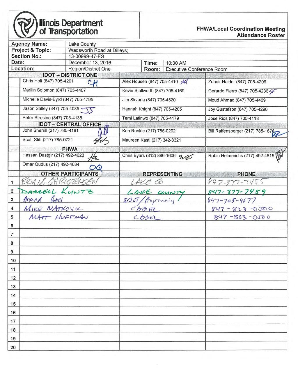
33 FHWA MEETING AGENDA ITEM # 4 Wadsworth Road Dilleys Road, US-41, and Kilbourne Road Intersections Section ( ES & CH) Lake County Division of Transportation December 13, 2016 This was the 3 rd presentation of the project. The purpose of this presentation was to provide a project status update since the last FHWA meeting (July 12, 2016), and to discuss selection of preferred alternatives, environmental survey request/clearances, and next steps with the Dilleys/Kilbourne Road intersections. An agenda was distributed to attendees with project location exhibit and the finalist alternatives exhibit boards on display for presentation/discussion purposes. Introductions were made, and a copy of the sign-in sheet is attached. A brief summary of the last FHWA coordination meeting was provided, at which the US 41 intersection was separated out as an independent project (Sec. No CH) from the Dilleys Road and Kilbourne Road intersections ( ES). Preferred Alternative Selection The second Public Information Meetingwas held in June 2016 where the Finalist Intersection Alternatives were presented for public comment for the intersections of Wadsworth Road with Dilleys Road, US-41, and Kilbourne Road. A comparative evaluation of the alternatives was presented to meeting attendees that included traffic performance, safety, environmental impacts, socio economic impacts, and cost. Follow up coordination meetings were held with numerous stakeholders to gather further input on the Finalist Intersection Alternatives before the Preferred Intersection Alternatives were selected. Based on all analysis and input received, Alternative D.2A was selected as the preferred alternative for the Dilleys Road intersection consisting of a single lane roundabout. This alternative was selected over the other finalist alternative, a signalized intersection, as it is a better countermeasure to the identified crash patterns and has better transportation performance. This intersection is currently on the IDOT 5-percent list. There is property acquisition from six parcels at this intersection. At the Kilbourne Road intersection, Alternative K.1A was selected as the preferred alternative consisting of the addition of a southbound right turn lane with maintaining the existing eastbound bypass lane. This alternative was selected over the other finalist alternatives, the addition of southbound right turn and eastbound left turn lanes (K.1B) and a single lane roundabout (K.2A), as it addresses the capacity issues most economically. The bypass lane was determined to operate properly as there were 5 crashes over a five year period at the intersection and no crash patterns associated with the bypass lane were identified. The pavement of Wadsworth Road is in good condition and reconstruction is not warranted. There is property acquisition from two parcels at this intersection, of which one is owned by the Lake County Forest preserve District (LCFPD). The LCFPD property does not have any existing or proposed recreational uses. However, FHWA requested that de minimis impact finding be obtained for the necessary acquisition from the LCFPD based on the intended us as property preservation. The LCFPD is on the SIG and 1
34 numerous individual coordination meetings have been held to discuss the alternative development and associated impacts. At the US-41 intersection alternative 1.A2 was selected as the preferred alternative consisting of additional lanes to the existing intersection on all legs of the intersection. This alternative was selected over the other finalist alternative, a grade separation of Wadsworth Road with a northwest quadrant jug handle (3.E2), as a more cost effective solution. Further discussion regarding the preferred alternative selection will be discussed at a subsequent FHWA meeting. Environmental An ESR was submitted for the project in June Cultural clearance and the PESA for the US- 41 right-of-way was received, but biological survey results are outstanding. IDOT CBLRS will check on the status of the biological surveys. An Addendum ESR will be submitted for the project to request separate biological clearances for the Dilleys Road and Kilbourne Road intersections and the US-41 intersection since they have been separated into independent Phase I projects. Additionally, the ESR boundary needs to be expanded for the US-41 intersection further north and south along US-41. The project team indicated they are ready to submit the Wetland Impact Evaluation (WIE) for the Dilleys Road and Kilbourne Road intersections, but not the US-41 intersection. IDOT CBLRS provided general wetland mitigation requirements to the project team with regards to keeping them in-basin. It was stated that the wetland impacts will be banked and a site has been identified in-basin. There is approximately 0.79 acres of wetland impact at the Dilleys Road intersection and 0.05 acres of wetland impact at the Kilbourne Road intersection. FHWA confirmed that no noise analysis is needed for the Dilleys Road and Kibourne Road intersections. It was stated that noise analysis will be required for the US-41 intersection improvement since additional lanes are being added at the intersection. Project Development & Schedule The Dilleys Road and Kilbourne Road intersections are being processed together as a Federal Approved CE (BLR 22210). The US-41 intersection will be presented at a subsequent FHWA meeting to discuss the preferred alternative and associated impacts to confirm the project can continue as a Federal Approved CE. A spring 2017 Public Hearing is being targeted for the Dilleys Road and Kilbourne Road intersections. FHWA stated that a Public Hearing is not required for these intersections and a Public Meeting is acceptable. FHWA stated that IDOT BLR should review a draft PDR and the project should have all environmental clearances prior to holding the final Public Meeting for the Dilleys Road and Kilboure Road project. The section 4(f) de minimis documentation should also be advertised and shown at the Public Meeting. The Dilleys Road intersection is targeted for a 2018 construction letting. Matthew J. Huffman - CBBEL 2
35
SECTION 4(f) DE MINIMIS DOCUMENTATION
 DE MINIMIS DOCUMENTATION") SECTION 4(f) DE MINIMIS DOCUMENTATION Illinois Route 60/83 IL 176 to the intersection of IL 60 (Townline Road) Lake County P-91-084-07 Mundelein Park and Recreation District Project Limit SECTION 4(f)
SECTION 4(f) DE MINIMIS DOCUMENTATION Illinois Route 60/83 IL 176 to the intersection of IL 60 (Townline Road) Lake County P-91-084-07 Mundelein Park and Recreation District Project Limit SECTION 4(f)
The Illinois Department of Transportation and Lake County Division of Transportation. Route 173, including the Millburn Bypass
 The Illinois Department of Transportation and Lake County Division of Transportation welcome you to this Public Hearing for U.S. Route 45 from Illinois Route 132 to Illinois Route 173, including the Millburn
DuPage Mayors and Managers Conference June 21, 2013 TRANSPORTATION PROGRAM (STP) WORKSHOP
 WORKSHOP") DuPage Mayors and Managers Conference June 21, 2013 TRANSPORTATION PROGRAM (STP) WORKSHOP Lombard Village Hall Marilin Solomon, P.E. Field Engineer West Division (Central & North Central Cook County, DuPage
DuPage Mayors and Managers Conference June 21, 2013 TRANSPORTATION PROGRAM (STP) WORKSHOP Lombard Village Hall Marilin Solomon, P.E. Field Engineer West Division (Central & North Central Cook County, DuPage
PROJECT BACKGROUND. Preliminary Design Scope and Tasks
 PROJECT BACKGROUND Preliminary Design Scope and Tasks The purpose of this Study is the development of preliminary designs for intersection improvements for Trunk Highway (TH) 36 at the intersections of
The Village of Sugar Grove, in partnership with Kane County, the Illinois Department of Transportation, and the Illinois Tollway welcomes you to the
 The Village of Sugar Grove, in partnership with Kane County, the Illinois Department of Transportation, and the Illinois Tollway welcomes you to the first Public Meeting for the proposed interchange improvement
PROJECT STATEMENT LOCATION/DESIGN PUBLIC HEARING. 19 th AVENUE NORTH EXTENSION PROJECT FROM SPRINGDALE DRIVE TO NORTH 2 ND STREET/U.S.
 PROJECT STATEMENT LOCATION/DESIGN PUBLIC HEARING 19 th AVENUE NORTH EXTENSION PROJECT FROM SPRINGDALE DRIVE TO NORTH 2 ND STREET/U.S. 67 HEARING LOCATION: ERICKSEN COMMUNITY CENTER 1401 11 TH AVENUE NORTH
Public Hearing. Charlotte County-Punta Gorda MPO - Meeting Rooms A and B March 14, open house at 4 p.m., formal presentation at 5 p.m.
 Public Hearing Charlotte County-Punta Gorda MPO - Meeting Rooms A and B March 14, 2019 open house at 4 p.m., formal presentation at 5 p.m. Welcome to the Public Hearing for the Harborview Road (CR 776)
ITS Concept Development Activity Descriptions
 ITS Concept Development Activity Descriptions October 2015 Procedures are subject to change without notice. Check the NJDOT website to ensure this is the current version. Table of Contents Concept Development
ARGENTA TRAIL (CSAH 28/63) REALIGNMENT SOUTH PROJECT (CP 63-25)
 REALIGNMENT SOUTH PROJECT (CP 63-25)") ARGENTA TRAIL (CSAH 28/63) REALIGNMENT SOUTH PROJECT (CP 63-25) Preliminary Design Report February 2015 Prepared For: City of Inver Grove Heights Dakota County Prepared By: Kimley-Horn and Associates,
ARGENTA TRAIL (CSAH 28/63) REALIGNMENT SOUTH PROJECT (CP 63-25) Preliminary Design Report February 2015 Prepared For: City of Inver Grove Heights Dakota County Prepared By: Kimley-Horn and Associates,
PREPARED FOR: PLATTEVIEW ROAD CORRIDOR STUDY EXECUTIVE SUMMARY
 PREPARED FOR: PLATTEVIEW ROAD CORRIDOR STUDY EXECUTIVE SUMMARY SEPTEMBER 2016 Introduction The Platteview Road Corridor Study was led by the Metropolitan Area Planning Agency (MAPA) with assistance from
Alternatives Development Three conceptual alternatives were developed for the Race Road/Jessup Village Planning Study and are described below:
 Race Road/Jessup Village Planning Study (H550601) Project Newsletter Spring 2015 Project Description The Study Team, consisting of staff from Anne Arundel County (Department of Public Works and Department
AGENDA ITEM: IOWA. west] that were not FISCAL IMPACT. the City of Clive. STAFF REVIEW. Resolution II. Amendment PREPARED BY: REVIEWED BY:
![AGENDA ITEM: IOWA. west] that were not FISCAL IMPACT. the City of Clive. STAFF REVIEW. Resolution II. Amendment PREPARED BY: REVIEWED BY:](/thumbs/93/112428810.jpg "AGENDA ITEM: IOWA. west] that were not FISCAL IMPACT. the City of Clive. STAFF REVIEW. Resolution II. Amendment PREPARED BY: REVIEWED BY:") AGENDA ITEM: CITY OF WAUKEE, IOWA CITY COUNCIL MEETING COMMUNICATION MEETING DATE: March 7, 2016 AGENDA ITEM: Consideration of approval of a resolution approving Engineering Services Amendment No. 1 with
AGENDA ITEM: CITY OF WAUKEE, IOWA CITY COUNCIL MEETING COMMUNICATION MEETING DATE: March 7, 2016 AGENDA ITEM: Consideration of approval of a resolution approving Engineering Services Amendment No. 1 with
City of Toronto. Emery Village Transportation Master Plan
 City of Toronto Emery Village Transportation Master Plan May 2009 Emery Village Transportation Master Plan Toronto, ON May 2009 Consulting Inc. 100 York Blvd., Suite 300 Richmond Hill, ON L4B 1J8 Tel:
CAG Meeting #4 Summary
 General Information, Overview, Purpose, and Goals The fourth Community Advisory Group (CAG) meeting for the Sugar Grove Parkway (IL 47) Interchange at the Reagan Memorial Tollway (I-88) Improvement Study
Pennsy Greenway Trail
 Town of Schererville Pennsy Greenway Trail DES. #s: 0401062, 1173595 & 1382661 Construction of Pennsy Greenway Trail beginning at Wilhelm Street and continuing northwest along the former Penn Central railroad
WELCOME! 8 8:30 6: TH STREET IMPROVEMENTS. Open House. Presentation & Q&A
 WELCOME! 168 TH STREET IMPROVEMENTS 6:30 Open House 7 8 Presentation & Q&A 8 8:30 Open House WELCOME Todd Pfitzer City of Omaha Engineer Bob Stubbe City of Omaha Public Works Director Jon Meyer Project
PUBLIC HEARING. Thursday, December 14, 2017 FDOT Urban Office 2198 Edison Avenue Jacksonville, FL 32204
 DISTRICT TWO PUBLIC HEARING I 10 (SR 8) from I 295 to I 95 Project Development & Environment Study Duval County, Florida Financial Project Number 213326 2 22 01 Efficient Transportation Decision Making
Project Overview. Fairfax County Parkway Widening Fairfax County. Get Involved. Public Information Meeting. Contact Information
 Get Involved VDOT representatives will review and evaluate information received as a result of this meeting. Please fill out the comment sheet provided in this brochure if you have any comments or questions.
Longmeadow Parkway Fox River Bridge Corridor. August 6, 2015
 Longmeadow Parkway Fox River Bridge Corridor August 6, 2015 Longmeadow Parkway Bridge Corridor 5.6 miles from Huntley Road to IL 62 Unique municipal/county/state/federal partnership Links Randall Road
OVERMOUNTAIN VICTORY TRAIL BURKE CALDELL CORRIDOR FEASIBLITY STUDY REQUEST FOR QUALIFICATIONS CALDWELL COUNTY PATHWAYS
 OVERMOUNTAIN VICTORY TRAIL BURKE CALDELL CORRIDOR FEASIBLITY STUDY REQUEST FOR QUALIFICATIONS CALDWELL COUNTY PATHWAYS Caldwell County Pathways along with our co-partners City of Lenoir, Town of Gamewell,
Clay Street Bridge Replacement Project
 Clay Street Bridge Replacement Project Frequently Asked Questions (FAQs) No. 2 April 4, 2018 The project is located in downtown Placerville on Clay Street between US Highway 50 and Main Street and Cedar
REQUEST FOR COUNCIL ACTION 6A AGENDA ITEM
 DATE REQUEST FOR COUNCIL ACTION 6A AGENDA ITEM ORIGINATING DEPT. AGENDA ITEM CITY ADMINISTRATOR APPROVAL Community Development PUD Concept & Development Stage Plan Preliminary Plat & Final Plat PREVIOUS
ESTABLISH AN EFFICIENT TOWN CENTER
 ESTABLISH AN EFFICIENT TOWN CENTER 4 Overview Lisbon residents are proud of the history of Newent and at the same time recognize its current importance as a centralized location for a variety of municipal
IOWA HIGHWAY 57 / WEST 1 ST STREET STUDY PUBLIC INFORMATIONAL MEETING APRIL 22, 2014
 IOWA HIGHWAY 57 / WEST 1 ST STREET STUDY PUBLIC INFORMATIONAL MEETING APRIL 22, 2014 INTRODUCTION The City of Cedar Falls and the Iowa Department of Transportation are conducting a Public Informational
Transportation Committee
 Transportation Committee Business Item No. 2013-286SW Meeting date: October 14, 2013 For the Metropolitan Council meeting of October 16, 2013 Subject: Southwest Light Rail Transit (Green Line Extension):
Scope of Services. River Oaks Boulevard (SH 183) Corridor Master Plan
 Corridor Master Plan") Scope of Services River Oaks Boulevard (SH 183) Corridor Master Plan PROJECT AREA The project area consists of the River Oaks Boulevard (SH 183) corridor bounded by SH 199 at the northern end and the Trinity
Scope of Services River Oaks Boulevard (SH 183) Corridor Master Plan PROJECT AREA The project area consists of the River Oaks Boulevard (SH 183) corridor bounded by SH 199 at the northern end and the Trinity
Kankakee River Bridge & Track Improvements Supplemental Environmental Assessment. May 5, 2016
 Kankakee River Bridge & Track Improvements Supplemental Environmental Assessment May 5, 2016 1 History: Chicago-St. Louis Corridor Since 1980 s IDOT has been looking at this corridor for high-speed service
Elgin O Hare Western Access Project Local Advisory Committee. February 10, 2014
 Elgin O Hare Western Access Project Local Advisory Committee February 10, 2014 Agenda Project status update Design and construction Funding Aesthetics Project events and outreach Land acquisition Next
Services Department F May 28, 2007
 Report To: Development Services Committee Item: Date of Report: From: DS-07-144 May 23, 2007 Commissioner, Development File: Date of Meeting: Services Department F-7000-0013 May 28, 2007 Subject: Gibb
Project Overview. Get Involved. Public Information Meeting. Contact Information
 Get Involved VDOT representatives will review and evaluate information received as a result of this meeting. Please fill out the comment sheet provided in this brochure if you have any comments or questions.
I-494 Rehabilitation Project SP (I-394 to Fish Lake Interchange) June 2014 Section 4(f) De Minimis Determination
 June 2014 Section 4(f) De Minimis Determination") I-494 Rehabilitation Project SP 2785-330 (I-394 to Fish Lake Interchange) June 2014 Section 4(f) De Minimis Determination State Project Number 2785-330 Federal Project No. NHPP-I494 (002) Trunk Highway:
I-494 Rehabilitation Project SP 2785-330 (I-394 to Fish Lake Interchange) June 2014 Section 4(f) De Minimis Determination State Project Number 2785-330 Federal Project No. NHPP-I494 (002) Trunk Highway:
Bostwick Road. Municipal Class Environmental Assessment. Public Information Centre #2 June 14, City of London
 Bostwick Road Municipal Class Environmental Assessment Public Information Centre #2 June 14, 2017 Welcome! Welcome to the 2 nd Public Information Centre for the. Representatives from the and the consulting
PARISH OF ASCENSION OFFICE OF PLANNING AND DEVELOPMENT PLANNING DEPARTMENT. Joint Planning and Zoning Meeting
 1. Call To Order 2. Roll Call of Members 3. Chairman's Comments PARISH OF ASCENSION OFFICE OF PLANNING AND DEVELOPMENT PLANNING DEPARTMENT Joint Planning and Zoning Meeting January 11, 2017 6:00 PM Courthouse
RFP REQUEST FOR PROPOSALS CITY OF PORTSMOUTH, NH. DESIGN ENGINEERING SERVICES North Mill Pond Trail and Greenway
 RFP 61-18 REQUEST FOR PROPOSALS CITY OF PORTSMOUTH, NH DESIGN ENGINEERING SERVICES North Mill Pond Trail and Greenway Sealed Requests for Proposals, plainly marked RFP 61-18 Design Engineering Services
Mavis Road Class Environmental Assessment
 Mavis Road Class Environmental Assessment Public Information Centre #2 Wednesday November 9, 2016 6:00 to 8:00 p.m. Please sign in and complete a comment sheet Review the displays on your own or join in
Rezoning Transportation Analysis Petition Number: General Location Identifier:
 From: Kelsie Anderson, PE Kelsie.Anderson@charlottenc.gov 704-432-5492 Staff Reviewer: Kory Hedrick, PE, PMP Khedrick@charlottenc.gov 704-432-6511 CDOT s review of this rezoning petition is intended to
We d like to thank you for attending this Wekiva Parkway Section 8 Preliminary Design Update hosted by the Florida Department of Transportation.
 We d like to thank you for attending this Wekiva Parkway Section 8 Preliminary Design Update hosted by the Florida Department of Transportation. We will provide you information on the overall project and
WURZBACH PARKWAY WURZBACH PARKWAY
 WURZBACH PARKWAY WURZBACH PARKWAY From Lockhill-Selma Rd to NW Military Hwy Open NW Military HouseHwy/Lockhill-Selma Open House Barshop Jewish Community Center December Barshop Jewish 14, 2017 Community
Ref: March 21, Ms. Jody Kablack Director of Planning and Community Development Town of Sudbury 278 Old Sudbury Road Sudbury, MA 01776
 35 New England Business Center Drive Suite 140 Andover, MA 01810-1066 Office: 978-474-8800 Fax: 978-688-6508 Web: www.rdva.com Ref: 7198 Director of Planning and Community Development Town of Sudbury 278
7.5 Impacts on the Section 4(f) Properties
 Properties") constructive use, such as noise, air quality and visual impacts were also assessed. It was determined that this project would not introduce changes of an external nature that would affect the recreational
constructive use, such as noise, air quality and visual impacts were also assessed. It was determined that this project would not introduce changes of an external nature that would affect the recreational
NORTH-SOUTH CORRIDOR STUDY EXECUTIVE SUMMARY. Executive Summary
 Executive Summary Background As congestion continues to affect mobility in the region, the Ozarks Transportation Organization (OTO) is particularly concerned with traffic movement. The North-South Corridor
Project Purpose. Project Need
 Project Purpose The purpose of the project is to implement a bridge improvement solution that corrects the existing safety problem at the Strasburg Pike Bridge. The project will provide a structurally
Meeting Display Boards for Public Hearing on the Wilson Transfer Station Project held Tuesday, February 18, 2014.
 Meeting Display Boards for Public Hearing on the Wilson Transfer Station Project held Tuesday, February 18, 2014. Board 1: Welcome Welcome to the Wilson Transfer Station Project Public Hearing. The purpose
SCARBOROUGH RAPID TRANSIT ENVIRONMENTAL PROJECT REPORT CHAPTER 2 PROJECT DESCRIPTION. Table 2-4: North Segment Alignment Analysis 2-21
 Table 2-4: North Segment Alignment Analysis 2-21 SCARBOROUGH RAPID TRANSIT Based on the above analysis (detailed analysis is contained in Appendix A-4), North Alignment 3 is preferred because it: Has the
Highway 12 Sibley Avenue Reconstruction. Project Overview and Progress To Date Litchfield City Council April 17, 2017
 Highway 12 Sibley Avenue Reconstruction Project Overview and Progress To Date Litchfield City Council April 17, 2017 Agenda Item Topic 1) Project Purpose and Need 2) Key Recommendations from Study 3) Preliminary
112th Avenue Light Rail Options Concept Design Report JUNE 2010 PREPARED FOR PREPARED BY TBG PGH
 112th Avenue Light Rail Options Concept Design Report JUNE 2010 PREPARED FOR PREPARED BY TBG060310124909PGH C ontents Introduction 1 Project Overview 1 Public Involvement and Technical Coordination 4 Description
DRAFT MAP AMENDMENT FLU 04-4
 DRAFT MAP AMENDMENT FLU 04-4 SW 24 TH AVENUE ROADWAY CORRIDOR The University of Florida participates with the Metropolitan Transportation Planning Organization (MTPO) in its responsibilities for the continuing,
Don Mills Crossing Study and Celestica Lands Development Application Community Meeting, Open House, and Breakout Discussions
 Consultation Summary Don Mills Crossing Study and Celestica Lands Development Application Community Meeting, Open House, and Breakout Discussions This report is not intended to provide a verbatim transcript
1.0 INTRODUCTION 1.1 TH 14 WEST STUDY AREA Project Description Functional Classification Purpose of the Project
 1.0 INTRODUCTION 1.1 TH 14 WEST STUDY AREA 1.1.1 Project Description The Trunk Highway (TH) 14 West Corridor is a two-lane roadway approximately 22 miles in length. Located in Nicollet County, the corridor
PRELIMINARY REPORT. HIGHWAY 18 CORRIDOR NEIGHBORHOOD PLAN VILLAGE OF DOUSMAN November, 2014
 PRELIMINARY REPORT HIGHWAY 18 CORRIDOR NEIGHBORHOOD PLAN VILLAGE OF DOUSMAN November, 2014 This preliminary report presents the initial recommendations for land use within the Highway 18 corridor along
Meeting Purpose: Date and Time: Location: Attendance: Handouts:
 Meeting Purpose: Date and Time: Location: Attendance: Handouts: PA Turnpike / I-95 Interchange Project Design Advisory Committee (DAC)/Public Officials Meeting #8 April 12, 2012 at 1:30 p.m. Project Office,
6:00 8:00 PM I-95 FROM EXIT 57 TO EXIT 60 PROJECT
 PUBLIC INFORMATIONAL MEETING TUESDAY, APRIL 27, 2010 AT NEWBURYPORT CITY HALL, AUDITORIUM 60 PLEASANT STREET NEWBURYPORT, MASSACHUSETTS 6:00 8:00 PM FOR THE PROPOSED WHITTIER BRIDGE / I-95 IMPROVEMENTS
Yadkin River Greenway Feasibility Study Fact Sheet Village of Clemmons, Town of Lewisville, Town of Bermuda Run
 Fact Sheet Village of Clemmons, Town of Lewisville, Town of Bermuda Run Project Background The Yadkin River Greenway Feasibility Study is a joint project with the Village of Clemmons, the Town of Bermuda
The transportation system in a community is an
 7 TRANSPORTATION The transportation system in a community is an important factor contributing to the quality of life of the residents. Without a sound transportation system to bring both goods and patrons
SH 199 Corridor Master Plan. Community Meeting No. 2 May 31, 2017
 Community Meeting No. 2 May 31, 2017 Transportation Projects On or Near SH 199 SH 199 from 0.3 miles south of FM 1886 to south end of Lake Worth bridge Construct freeway mainlanes and frontage roads 10-Year
THREE-YEAR CAPITAL IMPROVEMENT PLAN FY
 THREE-YEAR CAPITAL IMPROVEMENT PLAN FY2016 2018 Annual CIP Development Process Public Works & Engineering Divisions Prepare List of Capital Needs and Recommended Deferred Maintenance Public Works & Engineering
ALTERNATIVES. NCDOT made an early decision to first determine how to build the project (construction method) followed by what to build (alternatives).
 followed by what to build (alternatives).") III. ALTERNATIVES A. CONSTRUCTION METHOD ALTERNATIVES NCDOT made an early decision to first determine how to build the project (construction method) followed by what to build (alternatives). One of the
III. ALTERNATIVES A. CONSTRUCTION METHOD ALTERNATIVES NCDOT made an early decision to first determine how to build the project (construction method) followed by what to build (alternatives). One of the
Harlem Avenue Corridor Plan: Corridor Planning Across Municipal Boundaries
 Harlem Avenue Corridor Plan: Corridor Planning Across Municipal Boundaries Heather Tabbert, Manager, Local Planning and Programs Division Regional Transportation Authority (RTA) Jen McNeil Dhadwal, Principal
RESOLUTION NO. R Refining the route, profile and stations for the Downtown Redmond Link Extension
 RESOLUTION NO. R2018-32 Refining the route, profile and stations for the Downtown Redmond Link Extension MEETING: DATE: TYPE OF ACTION: STAFF CONTACT: Capital Committee Board PROPOSED ACTION 09/13/2018
Overall Map. Chicago. St. Louis. Summit. Joliet. Dwight. Pontiac. Bloomington-Normal Lincoln. Springfield. Carlinville. Alton EXPERIENCE IT YOURSELF.
 Overall Map Summit Chicago Bloomington-Normal Lincoln New Station Planned New Station Planned Dwight Pontiac Joliet Pedestrian overpass and second platform planned Higher speed service began in this section
A Claustrophobic Corridor Grows Up
 A Claustrophobic Corridor Grows Up Presenters: Chris Bauserman, PE, PS Delaware County Engineer Jeff Griffin, PE Burgess & Niple, Inc. Brian Moore, PE Burgess & Niple, Inc. PROJECT OVERVIEW Sawmill Parkway
7.0 DRAFT SECTION 4(f) EVALUATION
 EVALUATION") 7. DRAFT SECTION 4(f) EVALUATION 7.1 Background Information and Regulatory Requirements This chapter presents the existing conditions and potential effects on parks, recreation areas, wildlife and waterfowl
7. DRAFT SECTION 4(f) EVALUATION 7.1 Background Information and Regulatory Requirements This chapter presents the existing conditions and potential effects on parks, recreation areas, wildlife and waterfowl
CITY OF VACAVILLE PLANNING COMMISSION Item No. 8.A STAFF REPORT July 18, 2016 STAFF CONTACT: Amy Feagans, Contract Planner (707)
") CITY OF VACAVILLE PLANNING COMMISSION Item No. 8.A STAFF REPORT July 18, 2016 STAFF CONTACT: Amy Feagans, Contract Planner (707) 449-5140 TITLE: THE FARM AT ALAMO CREEK ENVIRONMENTAL IMPACT REPORT (EIR)
CITY OF VACAVILLE PLANNING COMMISSION Item No. 8.A STAFF REPORT July 18, 2016 STAFF CONTACT: Amy Feagans, Contract Planner (707) 449-5140 TITLE: THE FARM AT ALAMO CREEK ENVIRONMENTAL IMPACT REPORT (EIR)
DRAFT SECTION 4(f) EVALUATION INTERSTATE 73 FEIS: I-95 to I-73/I-74 in North Carolina
 EVALUATION INTERSTATE 73 FEIS: I-95 to I-73/I-74 in North Carolina") DRAFT SECTION 4(f) EVALUATION INTERSTATE 73 FEIS: I-95 to I-73/I-74 in North Carolina 1.0 INTRODUCTION Section 4(f) of the Department of Transportation Act of 1966, 49 U.S.C. 303, requires that prior to
DRAFT SECTION 4(f) EVALUATION INTERSTATE 73 FEIS: I-95 to I-73/I-74 in North Carolina 1.0 INTRODUCTION Section 4(f) of the Department of Transportation Act of 1966, 49 U.S.C. 303, requires that prior to
Request for Statement of Interest in Implementation of the Roosevelt Road Redevelopment Plan
 425 Hillside Avenue Request for Statement of Interest in Implementation of the Roosevelt Road Redevelopment Plan I. INTRODUCTION The is seeking the services of a qualified consulting firm to prepare plans
North Carolina Department of Transportation Project Development and Environmental Analysis Branch
 North Carolina Department of Transportation Project Development and Environmental Analysis Branch Citizens Informational Workshop I-85, from I-485 to NC 73 Mecklenburg and Cabarrus Counties October 30,
Drexel, Barrell & Co.
 Drexel, Barrell & Co. December 21, 2018 Engineers/Surveyors Boulder Colorado Springs Greeley 3 South 7 th Street Colorado Springs, Colorado 80905-1501 719 260-0887 719 260-8352 Fax El Paso County Planning
14 October 10, 2012 Public Hearing APPLICANT: MPB, INC
 14 October 10, 2012 Public Hearing APPLICANT: MPB, INC PROPERTY OWNER: MUNDEN & ASSOCIATES, LP STAFF PLANNER: Karen Prochilo REQUEST: Conditional Change of Zoning (AG-1 & AG-2 to Conditional O-2) ADDRESS
State Project No Heroes Tunnel
 Public Scoping Meeting State Project No. 167-108 Bridge No. 00773 Heroes Tunnel Route 15 Wilbur Cross Parkway Through West Rock Ridge Towns of Hamden, Woodbridge City of New Haven Agenda Show Project Location
Second Line West Pedestrian/Cyclist Crossing of Highway 401 Class EA. Second Line West Pedestrian/Cyclist Crossing of Highway 401 Class EA
 1 1 Purpose of Public Information Centre #2 To provide interested and/or potentially affected stakeholders with an opportunity to participate in the planning and decision-making process for this Municipal
Illiana Corridor CPG/TTF Meeting #1
 Illiana Corridor CPG/TTF #1 March 14, 2013 #10 1 Agenda Tier One Recap What happens in Tier Two? Tier Two Purpose and Need Identify Range of Alternatives Landowner Outreach Initial Context Sensitive Solution
BEST PRACTICES FOR PROJECT NOMINATIONS TA Set-Aside Program
 BEST PRACTICES FOR PROJECT NOMINATIONS 2017 TA Set-Aside Program Focus of this presentation Photos Public Support Maps & Exhibits Proposed Budget Design Details Project Evaluation & Selection Criteria
Public input has been an important part of the plan development process.
 Lakewood s Comprehensive Plan recognizes that transportation helps shape the community, and that the way the community provides for the safe and efficient movement of people affects the character of the
BRADENTON RIVERWALK EXPANSION MASTER PLAN
 BRADENTON RIVERWALK EXPANSION MASTER PLAN INTRODUCTION & AGENDA Process Update Community Engagement Summary Center for Active Design (CfAD) Recommendations Context and Existing Conditions Master Plan Alternatives
BOARD OF SUPERVISORS BUSINESS MEETING ACTION ITEM. Endorsement of Design for Route 7/George Washington Boulevard Overpass. Algonkian and Broad Run
 BOARD OF SUPERVISORS BUSINESS MEETING ACTION ITEM Date of Meeting: March 7, 2017 # 14 SUBJECT: ELECTION DISTRICTS: CRITICAL ACTION DATE: STAFF CONTACTS: Endorsement of Design for Route 7/George Washington
PLANNED UNIT DEVELOPMENT & SUBDIVISION STAFF REPORT Date: May 18, 2017
 & PUD-0000102-2017 PLANNED UNIT DEVELOPMENT & SUBDIVISION STAFF REPORT Date: May 18, 2017 NAME SUBDIVISION NAME Dauphin Creek Estates Subdivision Dauphin Creek Estates Subdivision LOCATION CITY COUNCIL
9IMPLEMENTATION AND PHASING
 9IMPLEMENTATION AND PHASING Purpose A key objective of the Railyard Master Plan is the integration of the public and private realm to provide a network of places that connect to and complement Commercial
BeltLine Corridor Environmental Study
 BeltLine Corridor Environmental Study Joint TAC and SAC Meeting December 8, 2008 What We Will Discuss Today Outreach and Agency Coordination Scoping Results Existing Conditions Historical and Archeological
CHARLES COUNTY GOVERNMENT RFP NO POPES CREEK RAIL TRAIL DESIGN
 CHARLES COUNTY GOVERNMENT Department of Fiscal and Administrative Services Purchasing Division Telephone: 301-645-0656 July 7, 2015 RFP NO. 16-02 POPES CREEK RAIL TRAIL DESIGN ADDENDUM NUMBER ONE TO: All
Welcome to the. Citizen Information Meeting for the Martinsville Southern Connector Study. The purpose of this meeting is to:
 Route Environmental Impact Statement Welcome to the Citizen Information Meeting for the Martinsville Southern Connector Study The purpose of this meeting is to: Introduce the Martinsville Southern Connector
Town of Windham. Planning Department 8 School Road Windham, ME voice fax
 Town of Windham Planning Department 8 School Road Windham, ME 04062 voice 207.864-5960 fax 207.892.1916 MEMO DATE: TO: Staff Review Committee FROM: Amanda Lessard, Planner Cc: Ellen Rathbone, St. Germain
Berkshire Regional Planning Commission Clearinghouse Review Report
 August 19, 2013 SUBJECT: Reconstruction of Housatonic Street, Dalton, MA EOEA#: 15083 LOCATION: Dalton ESTIMATED COST: $8.1 million REVIEW TYPE: ENF PROPONENT: MassDOT and Town of Dalton COMMENTS DUE:
Drexel, Barrell & Co.
 Drexel, Barrell & Co. June 18, 2018 Engineers/Surveyors Boulder Colorado Springs Greeley 3 South 7 th Street Colorado Springs, Colorado 80905-1501 719 260-0887 719 260-8352 Fax El Paso County Planning
Town of Portola Valley General Plan. Nathhorst Triangle Area Plan
 Town of Portola Valley General Plan Amended December 10, 1997 Table of Contents Introduction... 1 Planning Area... 1 Objectives... 2 Principles... 2 Standards... 4 Description... 4 Community Commercial...
WELCOME TO OPEN HOUSE TWO November 28, 2018
 Langstaff Road Weston Road to Highway 7 Class Environmental Assessment Study WELCOME TO OPEN HOUSE TWO November 28, 2018 Please sign in and join our mailing list Study Overview York Region is conducting
M E M O R A N D U M July 27, 2018
 M E M O R A N D U M July 27, 2018 To: Southlake 2035 Corridor Planning Committee From: Kenneth Baker, Sr. Director of Planning and Development Services Subject: Item #6 First National Bank Purpose Review,
PARTF Scoring System for Grants
 PARTF Scoring System for Grants The members of the N.C. Parks and Recreation Authority use the PARTF scoring system as one of several tools to select grant recipients. Please provide all of the information
Northern Branch Corridor SDEIS March 2017
 Northern Branch Corridor SDEIS March 2017 15. 15.1. Chapter Overview 15.1.1. Introduction This chapter discusses changes to the Preferred Alternative resulting in the potential for project improvements
Preliminary Design of Major Rehabilitation Works for the Bridge Structure on PTH 1A Over Assiniboine River and CP Rail (Bridge Site No.
 Preliminary Design of Major Rehabilitation Works for the Bridge Structure on PTH 1A Over Assiniboine River and CP Rail (Bridge Site No. 2582-00) Public Consultation Report December 2014 First Street Bridge
Chapter 1 - General Design Guidelines CHAPTER 1 GENERAL DESIGN GUIDELINES
 CHAPTER 1 GENERAL DESIGN GUIDELINES 1.0 INTRODUCTION This Publication has been developed to provide current, uniform procedures and guidelines for the application and design of safe, convenient, efficient
July 12, Columbus City Council City Hall 90 West Broad Street Columbus, OH RE: I-70/71 Columbus Crossroads Project
 OHIO DEPARTMENT OF TRANSPORTATION DISTRICT 6 400 EAST WILLIAM STREET DELAWARE, OHIO 43015 800.372.7714 Columbus City Council City Hall 90 West Broad Street Columbus, OH 43215-9015 RE: I-70/71 Columbus
Chapter 13: Implementation Plan
 Implementation A. Introduction The Implementation Plan, in table form on the following pages, provides a summary of all the Action Items recommended in Chapters 2 through 12. The table also indicates which
What We Heard Public Engagement - Stage 1
 What We Heard Public Engagement - Stage 1 Background Early planning is underway for a potential new river crossing over the North Saskatchewan River, in the northeast part of the Edmonton region. The City
STATE OF TENNESSEE DEPARTMENT OF TRANSPORTATION ENVIRONMENTAL DIVISION
 STATE OF TENNESSEE DEPARTMENT OF TRANSPORTATION ENVIRONMENTAL DIVISION Suite 900 - James K. Polk Building 505 Deaderick Street Nashville, Tennessee 37243-0334 MEMORANDUM TO: FROM: Files Joe W. Matlock,
REQUEST FOR COUNCIL ACTION 6A AGENDA ITEM ORIGINATING DEPT. AGENDA ITEM CITY ADMINISTRATOR APPROVAL
 DATE REQUEST FOR COUNCIL ACTION 6A AGENDA ITEM ORIGINATING DEPT. AGENDA ITEM CITY ADMINISTRATOR APPROVAL Community Development Territorial Greens PUD Concept Plan Development Stage Plan Subdivision (Preliminary
PLANNING APPROVAL & SIDEWALK WAIVER STAFF REPORT Date: December 1, 2016
 PLANNING APPROVAL & SIDEWALK WAIVER STAFF REPORT Date: December 1, 2016 NAME Dennis P. Wilkins LOCATION. CITY COUNCIL DISTRICT District 6 7078 Bruns Drive (Northeast corner of Bruns Drive and Cody Road)
PRELIMINARY CONDITIONAL USE SUBMITTAL CHECKLIST REQUIREMENTS
 This checklist must accompany your submittal as the cover page. CONDITIONAL USE Application Submittal Checklist for PRELIMINARY AND FINAL APPROVAL Per Winter Park Land Development Code Sec. 58-90 PRELIMINARY
AGENDA ACTION ITEMS INFORMATION ITEMS
 NOACA Bicycle and Pedestrian Advisory Council Meeting Friday, March 21 st, 2014 10:30 a.m. NOACA Office 1299 Superior Avenue Cleveland, Ohio 44114 Phone: (216) 241-2414; website: www.noaca.org AGENDA ACTION
COLVER ROAD INDUSTRIAL CONCEPT PLAN
 COLVER ROAD INDUSTRIAL CONCEPT PLAN A CONCEPTUAL LAND USE AND TRANSPORTATION PLAN FOR TA-4 AN URBAN RESERVE AREA OF THE CITY TALENT City of Talent Adopted by City Council Resolution No., June, 2015 PART
Parapet/Formliner/Fencing
 Parapet/Formliner/Fencing Cross Parapet/Formliner/Fencing Street Aesthetic Features Context The I-290 Phase I study is evaluating improvements along 13 miles of the Eisenhower Expressway, from west of