Prepared by. High Peaks Planning for the City of Placentia. City of Placentia 401 E. Chapman Avenue Placentia, CA (714)
|
|
|
- Godwin Boone
- 5 years ago
- Views:
Transcription


1 Revitalization Plan Prepared by High Peaks Planning for the City of Placentia City of Placentia 401 E. Chapman Avenue Placentia, CA (714)
2 1. Introduction This Old Town Placentia Revitalization Plan ( Plan ) is a comprehensive plan for the revitalization, activation, and growth of the City s original central business district founded in 1910 near the site of the original Placentia train depot and citrus packing houses. The area suffered from disinvestment and economic decline with the widespread growth of Orange County s suburbanization starting in the 1960s. However, existing property owners, residents, and businesses have kept the area active with a unique and diverse mix of small businesses, restaurants, churches, and other uses. This activity has helped this area retain some of its small town charm. Among Orange County s old towns, Placentia has retained its unique small scale environment with a rich variety of land uses. Today, population groups of all types are looking for small scale, walkable urban centers located around transit to live, work, and play. This is occurring in Orange County with new, more compact, and transit-oriented developments and historic reuse districts emerging in Anaheim, Orange, Fullerton, and Santa Ana. Coupled with the recently adopted Transit Oriented Development (TOD) Packing House District south of the railroad along Crowther Avenue, there is a unique opportunity for Old Town to see significant revitalization. This Plan focuses on an 18-year period, from 2017 to 2035 and is expected to be implemented in three phases under a partnership between Elected Officials, City Staff regional agencies, local businesses, residents, community organizations, and other stakeholders. PURPOSE The purpose of this Plan is to enhance the physical and economic environment in the City s Old Town aimed at creating a lively destination to support the current economic base, enhance the town center of Placentia, and better connect to adjacent neighborhoods and surrounding cities. The area s assets include a walkable layout with its short blocks across a linear street pattern. The Old Town, also known as Placita Santa Fe, has a good mix of commercial uses including popular restaurants, shops, and neighborhood serving stores. In 2016, the City of Placentia and the Orange County Transportation Authority (OCTA) approved a new Metrolink Station in the Old Town area. This Station, to be completed by 2019, is a primary element in the planned changes to the Old Town. The Station will have two July 11, 2017 Page 2


3 platforms, one north of the railroad and one south of the railroad. A pedestrian overcrossing bridge and a grade separated road at Melrose Street have been completed in anticipation of the station. The City has also adopted a zone change with corresponding development standards for a mixed use, transit-oriented development area to the immediate south of the Old Town, known as the Packing House District. Both plans will meld a cohesive vision for the area around the new transit station and will be tied together by a shared public realm plan. Metrolink Station. The new Placentia Metrolink Station will have two platforms, a north and south similar to this rendering. Pedestrian Friendly. The intersection of Santa Fe Avenue and Bradford Avenue will be the focal point of the Plan in look and function. The Plan covers both private property and public spaces, city and other government owned land, utility and service providers and addresses both public and private realms. It also provides direction on implementation and funding once this Plan is adopted. Responsibility for implementation includes the City of Placentia, regional governmental agencies, land owners, developers, business operators, and other stakeholders. This Plan is intended to represent a shared vision for the Old Town and will allow other, more specific planning and development to occur, as well as enable direction for seeking grant funding and other funding sources for construction of public improvements and infrastructure. An amendment to the City s General Plan and Zoning Code is being processed concurrently with the adoption of this Plan to provide a regulatory framework for private development within the Old Town. July 11, 2017 Page 3


4 BACKGROUND Placentia s Old Town constitutes the original town of Placentia, founded in 1910 and incorporated in The City has grown to a population of over 52,000 today. The Old Town developed around the original Placentia train depot and the citrus packing houses. Residential homes were typically Craftsman or California Bungalow style homes and duplexes built around the commercial and industrial uses. Afterwards, the Old Town transitioned to house more industrial and auto-related uses as the citrus industry declined. When the City incorporated, the Old Town was the location of City buildings, services, as well as commercial banking, shops and commerce. The City of Placentia considers investment in its Old Town one of the top priorities and has prepared this Plan as a comprehensive action plan to guide the area s development over the coming years. Prior planning and revitalization efforts included formal City redevelopment of blighted areas around the Old Town, using redevelopment funds, creating a specific zoning designation for the Santa Fe Commercial zoning district, and branding Old Town Placentia as an attraction. With the Placentia Metrolink Station nearing construction and past projects like the railroad grade separation projects, new transit oriented opportunities have presented themselves. The annual Los Posadas Tamale Festival hosted by the Placita Santa Fe Merchants Association has brought City-wide recognition to Old Town. The previously prepared Draft Westgate Specific Plan in 2006 (not adopted) was a more recent attempt to bring a broader vision to the Old Town. In that plan, revitalization of the City s historic core was included as a top priority. July 11, 2017 Page 4
5 COMMUNITY OUTREACH In preparation for the City of Placentia s Revitalization Plan for the Old Town area, a series of community meetings and workshops were conducted to gather the community s input and insight. This identified the community s goals and desires, and helped create a working glossary of terms related to the Plan. Data collected from the community workshops and public outreach was used to inform the vision, values, policies, and design elements of the Plan. Outreach efforts focused on meetings, community events, public workshops, and stakeholder comments. Discussions covered a range of topics, including vision, mobility, land use/density, business uses, streetscapes and landscapes, public spaces, wayfinding, programming, implementation, and funding. Outreach began with a collection discussion amongst a group of identified stakeholders, comprised of agencies, business owners, city-wide organizations, regional and local chambers of commerce, local merchant and business organizations, schools, and individuals from the community. Many of the identified stakeholders were similarly engaged during the 2006 Placentia-Westgate Specific Plan that was not formally adopted. Many participants were especially concerned with Old Town s perceived lack of safety. Stakeholders expressed an overwhelming need for a plan that implemented safety improvements, including a more consistent sanitation schedule, better lighting, and improved police surveillance. Stakeholders were additionally excited about plans that would offer enhanced parking opportunities, outdoor dining, additional retail and restaurants, and an improved connectivity between the new Metrolink station and its surrounding community. The first community workshop was held on February 19, 2016 to discuss the purpose of the plan as well as further opportunities to foster and encourage public involvement. The public was given a clear description of the project boundaries and was presented with a review of past recommendations made regarding the Westgate Specific Plan for context. Additionally, they received visual examples of design elements. Participants undertook a design exercise ( charrette ) intended to gather comments, ideas, and prioritize design elements. This activity took place amongst small groups, which presented their findings to the entire audience at the end of the activity. Common concerns included: poor landscaping, lack of street lighting, challenging parking, and physical deterioration. Common priorities included: improvement of private and public spaces, enhanced streetscapes, landscapes, improved lighting, sidewalks, July 11, 2017 Page 5
6 and alleys. The community desired an enhanced environment, that would be safer, more inviting, creating a better sense of place, while drawing from the historic importance in the area. The second community workshop was held on May 4 th, 2016, where the public was presented with both a summary of findings drawn from the previous meeting, as well as visual renderings of concepts, and alternatives for consideration. Participants discussed their impressions in small groups and emphasized the stated concerns regarding Circulation and Infrastructure, the public recommended better lighting and enhanced security, as well as two to four hour parking accommodations for downtown patrons. Regarding Density and Land Use, the public emphasized their desire for a more open market concept, as well as a premium coffee retailer. Regarding Streetscape and Landscape, the public requested a consistent aesthetic that would include curb appeal, earth tones, welcome signs, and street lights with hanging plants. They requested that bike racks, benches, planters, and welcome signs be prioritized, but they were also interested in more decorative focal points such as street art and a public gazebo in a small public plaza area. Regarding Identity and Programming, the public has a high interest in establishing funding streams to support improvements examples include the establishment of a lighting district, a business improvement district, and a special assessment. Lastly, there was an almost unanimous vote to change the district s name to Old Town Placentia, as well as the desire to phase out auto shops and phase in minor public/private improvements that would add to the vitality of the district. SETTING AND BOUNDARY DEMOGRAPHICS According to the Southern California Association of Government (SCAG) profile published in 2014, the City has a population of over 52,000 persons, representing 1.7 percent of Orange County s 3,113,991. Placentia experienced a growth rate that was higher than average for its area, 12.1 percent between 2000 and The population includes Hispanic (37.6 percent), Non-Hispanic White (42.9 percent), and Non-Hispanic Asian (15.0 percent), with Non-Hispanic Blacks, American Indians, and others making up the remaining 4.5 percent. There are an estimated 16,554 households within this population, and the median household income is $76,688 as of The homeownership rate is high at 64.6 percent. According to SCAG, the most common housing type is single family detached dwelling; 70.3 percent of the homes. As July 11, 2017 Page 6
7 of 2014, 84 percent of the population drives alone to work and 94 percent of Placentia s residents commute to other cities for their place of employment, Anaheim and Los Angeles ranking in first and second place. Placentia statistics show the City to have 19,581 jobs out of Orange County s 1,570,830 jobs. Between 2000 and 2014, Placentia saw a 3.7 percent reduction in the number of residents carpooling to work, which reflects the biggest change in transportation modes that were surveyed. There was a minimally detected increase in the number of residents who used public transportation. These demographics point to a stable, mostly single family residence, community with the potential for more sustainable transportation patterns. EXISTING ZONING, LAND USES, AND BUSINESS TYPES The Old Town is located in Placentia s southwestern quadrant and is a part of the north Orange County area. The Plan Area is about 32 acres in size and consists of 147 parcels made up of a diverse mix of commercial land uses, surrounded by residential neighborhoods to the west, east, and north. There are a few residential uses. Four community churches are within and surrounding the Old Town. Community facilities include the senior center and the fire station. Many parcels are less than 5,000 square feet in size, which contributes to the small scale of the Old Town. The Plan Area is centered along Bradford Avenue and Santa Fe Avenue and is bounded by Alta Street in the east, the Burlington Northern and Santa Fe Railway train tracks in the south, Chapman Avenue and Aguirre Lane on the north and Main and Murray Street on the west. To the north along Chapman Avenue is Kraemer Memorial Park. The immediately adjacent residential neighborhood to the north and west of the Plan Area, bounded by Chapman Avenue on the north and Murray Street on the west, is made up of primarily single family and duplex homes built during the Old Town s initial development period, many designed in the Craftsman or California Bungalow architectural style. The Plan Area includes all of the current SF-C Santa Fe Commercial District zone (Chapter of the Code) and other parcels in the C-1, C-2, and R-2 zones (see Existing Zoning Map below). The Plan Area does not include any schools, however, Valencia High School is located just to the north of Chapman Avenue. California State University Fullerton is located approximately two miles to the west, in the City of Fullerton. Surrounding cities include Anaheim to the south, with large industrial tracts, and Fullerton to the west with large residential and commercial zones. The 57 (Orange Freeway) and the 91 Riverside Freeway provide the most direct freeway access. Business organizations include the Placita Santa Fe July 11, 2017 Page 7

8 Merchants Association and the Placentia Chamber of Commerce. Long time establishments in the Old Town include the American Legion Post No. 277 and the Tlaquepaque Restaurant among others. CONSISTENCY WITH CITY POLICIES, CODES, AND PLANS Subsequent to the proposed General Plan and Zoning Code Amendments, this Plan is intended to be consistent with the City s General Plan, Zoning Code, Municipal Codes, and local and regional planning initiatives particularly for climate action, sustainability, circulation, complete streets, and livability. The City is currently in the process of updating the City s General Plan that was adopted in the 1980s. This Plan is intended to expand and update the purpose and reach of the Santa Fe Commercial District zoning code provisions, creating a new zone called Old Town, with revised development standards to accommodate the goals of the community and this Plan. This Plan has also been prepared to be complementary to the Transit Oriented Development Packing House District and development code for the area to the immediate south of the Old Town, separated by the Burlington Northern-Santa Fe (BNSF) railroad tracks. July 11, 2017 Page 8
9 Map 1: Old Town Placentia Existing Zoning Map 2. Vision The vision for revitalization of Old Town Placentia includes a combination of historic preservation, infill complementary development, creation of unique public spaces, and designating it transportation hub, all to provide this downtown core with a special identity to call its own. Placentia is generally considered a bedroom community, with a large portion of the City s land uses devoted to single family homes and apartment. While this character is important to the City s identity, it is also important to present a different part of the City, unique and tied to the past. AN ACTIVE OLD TOWN The vision for Old Town Placentia is to create a central gathering space inclusive of all population groups in the City and the region. A place where residents can walk to the corner store, go to dinner, congregate, shop, and relax in one place without parking more than once. This Plan strives to improve the built environment of the Old Town while also enhancing the human environment, creating more opportunities for people to interact. The Plan is intended to attract customers, visitors, nearby residents, and travelers to destinations and to encourage people to stay longer by highlighting the aesthetics, views, scenes, and businesses of Old Town. PHOTO SIMULATION. Streetscape design considered first the private and public realms and is a way to bring the two together for creating an inviting atmosphere for working, living, visiting, and shopping as well as helping to define the multimodal roadway for people of all ages and abilities. Pedestrians and cyclists have space to July 11, 2017 Page 9

10 interact with the environment. Landscaping, hardscapes, and street furniture provide a pleasant atmosphere. Central to the Plan is the creation of a Pedestrian Priority Zone" around the intersection of Bradford and Santa Fe Avenue and a pedestrian network with primary paths along streets and secondary paths along alleys, behind buildings. The short blocks that are the original layout of the Old Town are very walkable and are preserved in the Plan. WALKABLE DESTINATIONS. By designating a Pedestrian Priority Zone in the Plan, circulation, landscape, safety improvements, as well as land use development decisions, will work better together. Destinations within and surrounding the Old Town will feel closer together and easily reached on foot, especially for children and the elderly. Legend Pedestrian Priority Zone July 11, 2017 Page 10


11 Preserving the current diverse mix of land use types is important as well as supporting small businesses, public buildings, and housing. Although the area has developed with auto-related and industrial uses over the years, the goal is to phase out those types of uses to enhance more intense commercial development that contributes to a more pedestrian friendly environment. LOOK AND FEEL The vision is to create a unique and distinguishable look and feel to Old Town Placentia that is unique and slightly different from other old towns in Southern California by retaining the small scale buildings and shopfronts with smaller parcels, walkable blocks, and building frontages that are complementary to the public, pedestrian-scale spaces. The Old Town currently has a village character and the goal is to preserve and enhance that image. Specifically, the objective is to preserve the commercial block style of building characteristic of Old Town Placentia. Buildings are built side by side and are placed at, or close to the public right of way line, with very little interruptions for driveways and parking. Uses typically include shops, restaurants, and other attractions on the ground floor and offices and residential uses on the top floors. Building façades are well articulated and focus on openings, proportions, entries, and embellishments that add to the attractiveness of the area. Infill development is encouraged to help create the compact walkable environment important to a vital town center. The Plan defines a look and feel for Bradford Avenue that is complementary but distinguishable from Santa Fe Avenue through streetscape and landscape features. Current building heights at two stories could be preserved around the Pedestrians Priority Area with increased allowances to three and four stories on the outer edges, but still retaining the commercial block style of buildings. July 11, 2017 Page 11
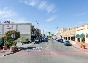
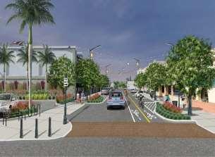
12 BEFORE. Intersection at Santa Fe Avenue and Main Street looking east showing wide lanes with street parking, narrow sidewalks, a lack of landscaping, and no designated areas for cyclists. AFTER. The Plan calls for a complete streets approach which makes public spaces important for all users. The Plan calls for narrowing roadways for vehicles and widen sidewalks to create an attractive and inviting pedestrian realm. A SUSTAINABLE FUTURE The Plan also includes provisions for sustainable development by creating a multimodal transportation hub around the Metrolink Station. The objective is to increase active transportation modes such as walking and bicycling alone or in combination with transit. A multimodal future is built into the plan by placing less emphasis on development around the automobile and creating a multimodal place providing more options for pedestrians and cyclists. Cities across the nation are implementing policies to enhance public health, public safety, and the environment. This includes the creation of a sustainable environment that encourages community activity and addresses climate change as well. There are multiple strategies that can be used to improve air quality and conserve water. The Green Cities program plays a role in reducing waste by having recycling, reuse and composting programs. Its mission is to accelerate the adoption of innovative policies and practices that further sustainability at the local, State, and national levels and can be used as a model to guide the policies of this Plan. Green Cities support multimodal transportation that improves ease of access to a variety of transportation methods such as walking, cycling, and public transit. Green infrastructure includes innovative water drainage systems, water retention, and sustainable landscaping to ensure water quality and conservation. PLAN GOALS AND POLICIES The goals and objectives of the Plan are to support an enhanced the environment which will encourage more capital improvements and serve as a catalyst for stimulating private investment. 1. Goal: Make Old Town Placentia a Unique Destination Policies: July 11, 2017 Page 12
13 A. Celebrate the City s heritage B. Make connections to the past C. Create a walkable village atmosphere D. Build public gathering spots E. Enhance the Old Town s identity overall F. Highlight historic features G. Revitalize historic resources H. Improve public and private spaces I. Create a diversified commercial base J. Create a shopping and dining destination 2. Goal: Make Old Town Placentia a Pedestrian, People Priority Zone Policies: A. Encourage compact and integrated development B. Encourage outdoor dining C. Provide for small passive recreation spots D. Support inclusivity across all walks of life E. Enhance community facilities and services F. Build lively streetscapes G. Create a small-scale village environment H. Get people to stay longer I. Create a safe, inviting, pleasant, attractive and appealing sense of place J. Tuck away parking where feasible K. Avoid conflicts with motor vehicles L. Provide opportunities to create intimate walkways M. Make the Old town walk-friendly for all ages and abilities N. Limit vehicular trips 3. Goal: Promote Multi Modal and Sustainable Transportation Policies: A. Integrate Old Town with surrounding neighborhoods and commercial districts B. Encourage use and increased ridership of the Metrolink System C. Move away from the auto-orientation in the layout and land uses July 11, 2017 Page 13
14 D. Provide hubs for various transportation modes 4. Goal: Support Businesses and Provide for Development Opportunities Policies: A. Enhance safety and security B. Develop incentive programs C. Support community events that bring different communities together D. Provide business start-up opportunities E. Promote the Old Town through media and outreach F. Provide for infill development, reuse, and preservation G. Develop a promotional and branding campaign to encourage visits to Old Town Placentia July 11, 2017 Page 14
15 3. Mobility The development of the Old Town Placentia around the railway network was a key factor to the local citrus industry in the early 1900s. As a result, today the area is not well integrated into the arterial street network of the City and the north Orange County region. The area is somewhat by-passed and tucked away from view. Contributing to the Old Town s isolated feel is the blocking of local streets with dead-ends and limited access to major thoroughfares. The train tracks are an additional feature that contributes to the area s inaccessibility. With the coming of the Placentia Metrolink Station and the completion of grade separations, the area s local and regional connectivity will improve substantially, particularly for travelers using all types of transportation modes. The Metrolink Station provides the opportunity to reimagine getting to and from and around the Old Town. Recent circulation improvements include the pedestrian bridge over the BNSF tracks and the underpass at Melrose Avenue. Safety will be a driving factor in improving connectivity and will play a part in redesigning streets, sidewalks, and common public spaces, particularly where modes come together in a shared environment. The goal of this Plan is to make streets within and surrounding the Plan Area more accommodating and inviting for all users with varying abilities, a concept known as complete streets. LOCAL AND REGIONAL CONNECTIVITY It is important that the Old Town be better connected to the larger north Orange County economic, commerce, and population centers including major destinations like California State University Fullerton to the west, Placentia City Hall to the east, the TOD Packing House District to the south, and schools and neighborhoods adjacent to and surrounding the Old Town. COMPLETE STREETS Complete streets means that streets are designed for all users of the public roadways including bicyclists, transit users, pedestrians, vehicles and for all ages and abilities. To achieve this balance, a redesign of current roadway configurations may be necessary since much of the urban landscape between the 1920s and 1990s was centered around the automobile for movement and parking. Streets have traditionally been designed to move automobile traffic as fast and efficiently as possible with pedestrians given second priority. Increasing traffic congestion has made July 11, 2017 Page 15

16 streets less welcoming to pedestrians and cyclists. Streets are important for the livability of a community, and more and more people want to be able to walk and ride bicycles in their neighborhoods. More people are focused on healthy living, with includes better food choices, increased physical activity, reduced stress and the opportunity to relax and enjoy nature. To improve a more active lifestyle, many communities are taking steps to modify street designs to optimize their usability by a variety of users. With a complete streets model, pedestrians of all ages and abilities can be given safe spaces with continuous unobstructed sidewalks. Cyclists desire a safe, clearly designated and cohesive network of cycling lanes. Transit riders want convenient and reliable transportation that reduces traffic congestion. Children and adults want safe and inviting routes to schools and transit stations. Motorists need roadways that facilitate safe movement while still providing safe spaces for pedestrians and cyclists. Freight operators and service providers require safe accommodations for unloading and loading supplies via dedicated curb access. People doing business need adequate space to provide active and rich street environments. BRADFORD/SANTA FE INTERSECTION. The Plan proposes a pedestrian priority intersection where Bradford Avenue and Santa Fe Avenue meet. PEDESTRIAN OVERCROSSING BRIDGE. The existing pedestrian bridge over the BNSF railroad tracks provides a safe route between the two future Metrolink Platforms and will allow easy access to the Old Town from areas to the south. July 11, 2017 Page 16
17 FLEX STREETS This Plan considers that at various times of the year, certain streets could be easily closed for special events and festivals, day and night through provisions for flex streets. Flex streets provide communities a means to transform roadways into safe public areas for city supported functions. A flex street is a roadway that can be changed from vehicle-use to pedestrian use by strategic placement of removable bollards or other vehicular barriers. Vehicles can be prohibited from road use during pedestrian priority events to ensure a safe walking area. The Plan proposes that Bradford and Santa Fe Avenues from Center Street to Main Street be designated as flex streets for programming activities and special events to be coordinated with City departments, including Police, Public Works, and Orange County Fire. Flex streets in the Old Town would be sectioned off by removable bollards at Center Street and Main Street. Other flex streets can be created with removable bollards throughout the Old Town, providing options for temporary street closures for community events. July 11, 2017 Page 17
 can be easily converted into a Flex Street using physical temporary barriers such as rails and bollards that close the street in part or in full to vehicle traffic.")
18 SANTA FE AVENUE & BRADFORD AVENUE (from Center Street to Main Street). This street segment (s) can be easily converted into a Flex Street using physical temporary barriers such as rails and bollards that close the street in part or in full to vehicle traffic. This frees up public roadway space for community activities such as fairs and cultural festivals. Legend Full Vehicle Closure Partial Vehicle Closure TRAFFIC SAFETY This Plan considers that traffic safety and the reduction of collisions is a top priority. Although the Old Town does not suffer from many traffic collisions, the introduction of more pedestrians, bicyclists, and vehicles could increase the need for safety awareness and improvements to reduce any conflicts between the different types of users. July 11, 2017 Page 18
19 CIRCULATION This Plan recognizes that enhanced vehicle circulation will be important to moving through the Old Town, particularly in cases where drop off and pick up of passengers and goods occur. The proposed circulation for the plan area includes creating a one way circulation pattern starting at Center Street on Bradford Avenue, heading south to Santa Fe Avenue. This circulation plan includes bike lanes and parallel parking where right of way space allows. There are, like any active area, points where modes intersect and conflicts arise where traffic and pedestrians meet. Grade separated crossing with the Metrolink pedestrian bridge and the Melrose Street underpass have been completed reducing conflicts with the BNSF railroad. Throughout the Old Town, intersections and crosswalks are to be enhanced giving pedestrians more visibility and priority. TRANSIT SERVICE Important to creating a multimodal hub, is introducing various type of transit options for the Plan Area to include rail (Metrolink), bus (OCTA), and transit circulator (OCTA) routes, stations, and stops. Through enhancing the pedestrian realm within the Old Town, walking routes to transit stations and stops will be enhanced, creating an environment that promotes use of transit. The City is also reviewing the feasibility of a trolley service, which would stop near the Old Town area. July 11, 2017 Page 19

20 BRADFORD/SANTA FE INTERSECTION. The Plan proposes a pedestrian priority intersection where Bradford Avenue and Santa Fe Avenue meet. PEDESTRIAN OVERCROSSING BRIDGE. The existing pedestrian bridge over the BNSF railroad tracks provides a safe route between the two future Metrolink Platforms BICYCLE NETWORK Bicycle facilities increase mobility options for residents and guests. Bike lanes are important to mobility in the Old Town and are proposed for both Bradford and Santa Fe Avenues. To ensure that bike travelers will have places to keep their bicycles, short term and long term bicycle parking spaces should be considered with each new development and with the development of the streetscape plan. Short term bicycle parking spaces are bicycle racks while long term bicycle parking spaces are provided via paid bicycle lockers. Long term storage is particularly important for users of the Metrolink Station. Furthermore, a bicycle share program could be implemented for those without bicycles. This would enable bicycle commuters to connect with bicycle routes to Fullerton on the northwest and Anaheim in the south and allowing bicycle commuters to connect to residences on the eastern areas of the City. Where feasible, bike lanes will be installed in the Old Town district. Where the roadway cannot accommodate Class IV lanes, Class II or III can be installed. Bike lanes can be either one way or two, depending on the right of way width available. PEDESTRIANS NETWORK An overall goal of the Plan is to improve the walking environment for all visitors to Old Town. The Old Town Placentia Plan includes improvements to walkways for all users. Sidewalks along Bradford Avenue and Santa Fe Avenue can serve as the primary pedestrian network. These sidewalks widths are proposed to be widened from their current 5-feet up to 16-feet, with an average of 10-feet, depending on location and feasibility. Wider sidewalks will be achieved by July 11, 2017 Page 20


21 narrowing or redesigning roadways to provide more public space for pedestrian travel, landscaping, outdoor cafes, and streetscape amenities. This increases the priority for the pedestrian and can create a more active streetscape. The goal is to create more pedestrian routes that will help to bring destinations with the Old Town closer by allowing shortcuts and easier access between spaces. A secondary pedestrian network can be provided by activating existing alleys behind buildings. Alleys can be lined with green infrastructure to create more intimate and personal city spaces. Store owners can be encouraged to create secondary frontages along alleys and to maintain the rear entrances to their businesses. Alleys can be beautified in a way that they will also be utilized as off-street spaces for festivals and cultural activities as well. Naming of alleys as courts, lanes, etc. will help to create a sense of place with the Old Town. PRIMARY. Example of a small commercial block style buildings fronting a main street serves as the primary pedestrian travel route in the area. SECONDARY. In addition to providing parking and loading behind the buildings, the above example provides a secondary pedestrian and dining opportunities. STREET CROSS SECTIONS AND CIRCULATION PLAN The following pages contain illustrations show the vision for Bradford and Santa Fe Streets. July 11, 2017 Page 21


22 Bradford - Southbound Santa Fe - Westbound July 11, 2017 Page 22
23 RECOMMENDATIONS CIRCULATION, SAFETY AND FLEXIBLE STREETS 1. Promote the tenets of Complete Streets model and follow the City s Complete Streets Ordinance, once adopted. 2. Plan for Flex Streets that allow for community events and activities but also allow for temporary closures and redirection of traffic. 3. Widen sidewalks and reduce roadway widths where feasible to slow vehicle traffic and increase activity in the pedestrian realm. 4. Reduce speed limits to 15 miles per hour in the most highly concentrated pedestrian areas, based on the results of revised speed surveys. 5. Add signage at potential conflict points. 6. Open up closed streets and alleys to bicycles and pedestrians (keep existing closed to vehicles). 7. Open up more access routes into and out of the Old Town by opening through traffic in both directions along Melrose Street. 8. Designate a passenger drop off and pick up zone for the Metrolink Station. 9. Create a pedestrian priority intersection where appropriate, which will include where Santa Fe Avenue and Bradford Avenue meet. 10. Install enhanced crosswalk designs for increased visibility of pedestrians at all intersections in the Old Town. 11. Add signage and visual reminders for vehicles in and around the Old Town. 12. Designate emergency access routes reviewed and approved by Public Safety. 13. Conduct periodic reviews of the circulation system. TRANSIT 14. Include enhanced wayfinding for the Placentia Metrolink Station and parking structure. 15. Design and install enhanced bus shelters on Chapman Avenue. 16. Determine the feasibility of a local circulating bus or trolley that services the Old Town, the Metrolink Station, the TOD Packing House District and surrounding areas. 17. Consider a circulator stop near the proposed Metrolink parking structure. July 11, 2017 Page 23
24 18. Improve the vehicular circulation pattern within Old Town for better traffic flow and pedestrian safety. BICYCLE FACILITIES 19. Install bike lanes along both Bradford and Santa Fe Avenues. 20. Install short term and long term bicycle parking spaces at central and convenient locations, as development and streetscape improvements occur. 21. Investigate the feasibility of a bicycle share program for those without bicycles, particularly near the Metrolink Station. PEDESTRIAN 22. Where feasible, widen sidewalks to give priority to the pedestrian and to allow space for more active streetscape activities such as walking, outdoor dining, seating, and other amenities that improve the environment for the pedestrian. 23. Activate the alleys, and consider the alleys as a possible secondary pedestrian network and encourage secondary business entries there. 24. Consider greening the alleys. 25. Minimize driveways and curb cuts fronting main thoroughfares. 26. Encourage the maintenance of alleys by the business or property owners. 27. Consider alleys as off-street spaces for festivals and cultural activities. 28. Consider a program of community naming of the alleys. July 11, 2017 Page 24
25 4. Infrastructure To support any new infill development in the Old Town, an assessment of the capacity of the various infrastructure systems will need to be conducted. Because the Plan can allow for greater density through infill and increased height limits, the exiting systems will likely have to be upgraded. WATER This Plan considers that increased development may require upgrades to the current water lines and facilities. The Plan Area is served by water distribution supply lines ranging in size from 8-inches to 12-inches. Water supply assessment provided by Golden State Water Company. WASTEWATER This Plan considers that increased development may require upgrades to the current wastewater and facilities. The Plan Area is served by the City s sanitary sewer system. This system contains sewage collection piping ranging in size from 8-inches to 15-inches. DRAINAGE AND STORMWATER MANAGEMENT The Plan Area is served by a storm drainage system consisting primarily of pipes with diameters ranging from 8-inches to 60-inches, which ultimately drain to Carbon Creek. These creeks have been channelized in their downstream sections and are also used in conjunction with the storm drainage system for flood protection. Drainage in the Plan Area collects at Bradford and Santa Fe Avenues, and Melrose Street. July 11, 2017 Page 25


26 PAVEMENT. Permeable pavement treatments help to retain runoff and improve water quality. BIOSWALES. Swales help to ensure proper storm water drainage and water retention. UTILITIES The Plan area includes policies creating attractive public realm environment in all corners. To the extent feasible, overhead utility lines should be undergrounded or otherwise upgraded. July 11, 2017 Page 26
27 RECOMMENDATIONS WATER 1. Conduct a water supply and facilities assessment to determine the capacity of the network. 2. Center water facilities around the intersection of Bradford Avenue and Santa Fe WASTEWATER Avenue, near the new Metrolink Station. 3. Conduct a wastewater facilities assessment to determine the capacity of the network. 4. Center wastewater facilities around the intersection of Braford Avenue and Santa Fe Avenue, near the new Metrolink Station. DRAINAGE AND STORMWATER 5. Assess the capacity of the current drainage system to accommodate future development 6. Encourage stormwater capture and filtration through bio swales or other innovative and best management practices for private development and City projects. July 11, 2017 Page 27


28 5. Streetscapes Streetscapes are the common connectors between plazas, spaces, parking, and buildings. Streetscapes in the Old Town are proposed to provide for a clean, uniform, unified, uncluttered, and attractive shared environment, with a color scheme, style, and design tied to the City s heritage. Landscaping, wayfinding, amenities, street furniture, and related elements are to be integrated with the public realm guidelines of the TOD Packing House District to the south. PEDESTRIAN REALM The key component of the Old Town Placentia streetscape plan is the emphasis on a linear and parklike, pedestrian realm branching out from the new Metrolink Station area. The pedestrian realm design has been coordinated with the proposed Old Town circulation plan and land use plan as contained here. An enhanced pedestrian experience will occur through streetscape improvements that unify corridors with consistent tree palettes and planting. Pedestrian amenities such as benches, trash cans, bike racks, and pedestrian lighting will be added. Pedestrian amenities should be organized into clusters. Utility boxes that inhabit the roadway space should be wrapped with artistic materials that are evocative of Old Town Placentia. Shade structures can also be used to improve the pedestrian experience.. July 11, 2017 Page 28

29 OPEN SPACE AND PUBLIC PLAZAS Open space is integral to the success of the Plan in creating a destination and active town center. It is an important part of a commitment to provide places that promote the physical and emotional well-being of residents. Locating a space for a central public plaza is recommended. This public plaza could include a stage area, public amenities, landscaping and seating. The plaza could play an important role in community activities and festivals through the year and would be the central location for information and signage and could provide a focus to civic life in Placentia, provide shade, establish a focal point for the Metrolink Station, and attract visitors. Secondary to a public plaza could be a series of small open spaces to contain amenities, public art, and signage combined to produce an attractive and well maintained areas of interest, continuity in the outdoor environment. The Plaza complements commercial activity by allowing shoppers and patrons a place for respite amidst their activities. Instead of leaving the Old Town, pedestrians can retreat for a break. Public amenities contribute to an atmosphere and character, and help paint an area as a destination with a consistent planting palette and lighting scheme. July 11, 2017 Page 29
30 AMENITIES AND STREET FURNITURE Amenities in the public realm provide for shared features that make the area attractive as well as functional. Street furniture such as benches, decorative traffic signs, and trash receptacles coordinated in style and color enhances the feel of the Old Town. Options include a mixture of seating types, bike racks, etc. Furniture should sit in clusters and be organized in a way that does not feel cluttered and that provides pedestrians respite from street and shopping activity. Resting or seating areas should be organized around trees, planters, and green spots for access to shade and a more peaceful environment. Amenities can include fountains and water features. LANDSCAPE North Orange County's landscape is largely urbanized and populated with an eclectic palette of species. In the untouched, rural areas, the landscape is rustic, reflecting several large tree species such as eucalyptus, oaks, citrus and palms. The landscape plan includes street trees along Bradford and Santa Fe Avenues complemented by smaller planter boxes and ornamental plants. Landscapes shall preserve and promote the aesthetic character and value of Placentia's core by defining, unifying and enhancing the public realm while providing the passive solar functions of cooling in summer while allowing filtered sunlight and warmth in winter. Landscapes shall mitigate environmental degradation resulting from stormwater runoff. The landscape shall consist of elements consistent with the character, climate and soils of Placentia. As practical, plant materials will be indigenous to Placentia, or similar in character and habitat to indigenous materials and shall be of low water usage. Storm Water Best Management Practices will be established to improve water quality. Streetscapes as a major component of thoroughfares shall help define the street space as a safe environment for automobiles, cyclists and pedestrians while adding beauty and shade to the street. Indigenous trees such as, Oaks and Sycamores, shall be used to provide a sustainable habitat and reinforce the existing natural aesthetics of the open space framework. These trees are tolerant of stress created during periods of drought, and are receptive to eco-friendly integrated pest management. The open space system shall be complex and usable for a variety of active and passive purposes to serve a wide cross section of ages and abilities. July 11, 2017 Page 30


31 SIGNAGE Signage is a key navigation element of the Old Town Placentia Streetscape as it becomes more pedestrian oriented. Because signage is necessary for wayfinding, adds to the ambiance of an area and promotes city branding; a system of guidelines will be implemented to create a feeling of consistency in Old Town Placentia. Signage should indicate traffic direction, restrooms, parking lots, commercial areas, public transportation stops, and where to find city information. Signage should also be clear and easy to read. Signage should not cover the façades, doors, or windows of buildings and should be in proportion to the primary building façade. GATEWAY SIGNAGE. Marking the entrances into the Old Town will help to create the sense of place. WAYFINDING. Clear signage shows where specific areas can be found. LIGHTING An array of features should be lighted around the Old Town making the area attractive, inviting, and safe at night times. Lighting is a fundamental amenity for streets, access-ways, parking lots, plazas, and other public spaces and helps to establish a more human environment for walking and driving. Well-designed lighting also fosters a safer and more viable night-life atmosphere and adds a more festive and relaxing feeling. It can create interest by illuminating special locations and architectural and landscape features, and can help convey an overall feeling of activity during the evening. Lighting within the Plan Area would be pedestrian oriented and contribute to the overall experience of the environment. Commercial and mixed-use areas should exemplify the vitality of an active night-life while preserving the quality of the night sky. Street lighting should be pedestrian in scale. The illumination of signs, fountains, pedestrian crossings, and special features is encouraged, and the color and quality of the light should support the architectural character and textures of the building. Lighting fixtures to be spaced close together with lower light levels than further apart with intense and varied light levels. Light fixtures should not cause glares into the upper stories of buildings. July 11, 2017 Page 31


32 Architectural lighting should be encouraged and be consistent with the design vocabulary of the streetscape. Retail environments require special lighting to attract customers and promote the sale of merchandise. Interior lights should be directed towards the interior of the store, and varied light expression is encouraged. Retailers should make special effort to create interesting and dynamic storefronts while abiding by the concerns of light-wash and over-lighting. Parking structure lighting should be limited to highlighting special features such as green or living walls, stair and elevator core elements, lobbies, and signage. Pedestrian and vehicular entrances must be controlled to reduce glare and/or light wash. Residential and balcony lighting should be directed toward building walls. Light fixtures should be hidden or integrated into the architectural character of building. In general, balcony lighting should provide architectural highlights with no illumination beyond the direct boundary of the building. Security lighting should be connected to a timer and/or motion detector. PROMENADES. Open areas for pedestrians and outdoor business bring in more visitors. CAFES. Widened streets with landscaping and outdoor cafes provide areas that people can meet up at for a more vibrant streetscape. OUTDOOR KIOSKS To supplement the small-scale character, vitality, and diversity in the commercial atmosphere, Old Town may contain areas that are suitable for outdoor kiosks, which could sell retail goods and provide connectivity for cell phones and other devices. Kiosks can often help provide start-up and pop-up business opportunities and add a level of interest to the streetscape. HARDSCAPES AND PAVEMENT TREATMENTS Included in the streetscape pallet are hardscapes and pavement treatments incorporated to break up spaces and particularly to define node, centers, segments, and districts within the Old Town. Hardscape materials such as wood, brick, masonry, stones, can be artfully combined to create these edges. Roadway pavement is encouraged to support the pedestrian friendly environment. July 11, 2017 Page 32
33 PUBLIC ART The Old Town is also intended to be a center of arts and culture in the City. To reinforce that element, the Plan includes provisions for placement of public art. A public art program would be coordinated by City departments and community organizations and could include a mural program. RECOMMENDATIONS 1. Prepare a streetscape master plan based on the public realm document created for both Old Town and the TOD Packing House District. 2. Conduct a study to consider the feasibility of outdoor kiosks in the Plan area and create a Master Kiosk Plan before allowing these uses. 3. Conduct study to determine where public plazas would be feasible and develop a public plaza and open space plan. 4. Develop a Master Wayfinding Plan that would include both Old Town and the TOD Packing House District. July 11, 2017 Page 33
34 5. Parking Parking is an essential part of the success of the revitalized Old Town, and has contributed to limited growth and investment opportunities. Less land devoted to the automobile will make land uses and destinations with the Plan Area seem closer together and more easily accessible on foot. Currently, the Plan Area has on-street parallel and angled parking, surface public parking lots, and on-site private parking in addition to driveways associated with parking. Consistent with the objective of creating a pedestrian friendly walkable environment with a sense of place, the Plan encourages creative and reduced parking standards, similar to TOD style development. Because parcels are small, space should be restricted to buildings to help create that compact development with a large variety of uses. Some parking in the Old Town is intended to be shared public parking through on-street parking, City parking lots, and the Metrolink Parking structure to provide parking for both the Old Town businesses and Metrolink commuters. The structure is planned to provide space for approximately 253 vehicles within a five-level structure. Also included would be designated space for electrical vehicle charging, bicycle racks, and long term bicycle parking (lockers). July 11, 2017 Page 34

35 Public Parking Legend Existing Surface Parking Lot Future 253 Space Parking Structure RECOMMENDATIONS 1. Consider amenities such as electrical vehicle charging, bike storage and parking for shared car programs within new parking structures and surface lots. 2. Conduct an annual parking management study (required by OCTA) to ensure that sufficient parking is provided for Metrolink riders. 3. Employ parking management strategies to ensure a cohesive and coordination approach to all parking within the Old Town, including shared parking, valet parking, paid, permitted, time-limited, and other innovative parking approaches. July 11, 2017 Page 35
36 6. Land Use The vision for the land use of private and public land is to keep development compact by providing opportunities for infill that preserves the small-scale character of the area and places increasing height away from the historic core. A portion of the Plan area encompasses surface parking lots and driveways, and the objective would be to convert that space to development use for stores, restaurants, offices, and residential uses. The Plan also includes opportunities for rehabilitation, additions, and alterations to existing properties. The objective is to create a more compact commercial core district, keep parcel sizes small as they currently exist, consolidate, as necessary, in height districts 3 and 4 to create larger development sites. TYPES OF USES The Plan s vision is to encourage a continuing and robust mix of uses oriented around this unique destination. The goal for commercial diversity includes a healthy mix of retail, restaurants, and office uses combined with outdoor gathering spaces such as public plazas. In addition, office and service uses would be secondary and permitted on the second floor of the Plan area buildings, providing an important element to create a more full service area. A list of permitted uses are contained in the Old Town Development Standards, approved as a Zone Change. ZONING DISTRICTS The Plan Area includes all of the current SF-C Santa Fe Commercial District zone (Chapter of the Code) and some surrounding parcels in the C-1, C-2, and R-2 zones. The Plan proposes the area to be rezoned as Old Town and further divides the Old Town into five main planning sub areas to guide new development, infill, preservation, and reintegration of land uses. These subareas were drawn around distinctive areas or locations in the Plan area, with distinctive standards. July 11, 2017 Page 36

37 Main Street (Two, Three and Four Story Height Subareas). This subarea is found along both Bradford Avenue and Santa Fe Avenue from Center Street to Main Street and will be small in scale with frontages that blend with the streetscapes. This is also within the Pedestrian Priority Zone and the one-way travel segments. The height limit varies from two to four stories, with the higher four story height limit being permitted along Santa Fe Avenue. The focus is on historic rehabilitation, Main Street architecture and infill development to create a dense urban segment. Uses would be limited to commercial uses that occupy smaller spaces and attract a large number of visitors. The Development Standards for this subarea call out several parking reductions. The Main Street (MS) subarea provides for the preservation and enhancement of the unique character of the historic Old Town commercial area with commercial block building forms and shopfront architecture. The north and south sides of Santa Fe Avenue from its intersection with Bradford Avenue to the first block west of Melrose Avenue is characterized by commercial block buildings at the back of the sidewalk. This pattern would be repeated along the Bradford Avenue segment. The historic character of existing buildings is to be preserved where sufficient architectural integrity remains, and new buildings are to be designed to be compatible with the historic character of the area in the commercial block style. July 11, 2017 Page 37
38 Allowable land uses emphasize ground floor retail, restaurant, and related uses, with opportunities for offices above. The restoration and renovation of existing façades is encouraged. Parking is on-street, in existing and proposed surface lots, and in park-once surface lots/garages. Buildings are to be built to the front property line along both Bradford Avenue and Santa Fe Avenue. A small rear, alley set back is required for vehicle loading, amenities, and for each business and building. Village (3 Story Height Subarea). This subarea is found in two separate places. One at the north end at the southwest corner of Chapman Avenue and Bradford Avenue extending south along both sides of Bradford Avenue and the other at the west end along both sides of Santa Fe Avenue from Melrose Street on the east to Murray Street on the west. The intent is to create new and infill development opportunities while recognizing existing historically significant properties such as the old City Hall and the Library. The Village (V) subarea provides for a new walkable retail and office center as an extension of the Main Street district. The Village subarea would provide for the same building form and setbacks as the Main Street subarea but would allow three stories. In this zone, the primary frontages along Bradford and Santa Fe Avenues would orient to the street with zero to five foot front setbacks and a zero to fifteen foot rear setback for secondary frontages along the alleys. Ground floor spaces would be occupied by retail and restaurants, with offices and residential above. Building types are intended primarily to be a cohesive design with well-defined frontages in the shopfront style similar to the Main Street subarea. High Density Residential (Four Story Height Subarea). There is one subarea in the Old Town designated for high density residential development. This can be four stories in height and is located along Baker St and Walnut Avenue at the south west corner of the Plan area, just north of the railroad tracks. Mixed Use (Four Story Height Subarea).This subarea is found at the southeastern corner of Bradford and Chapman. The Mixed Use subarea provides for a mix of concentrated urban housing types with some commercial uses, within convenient walking distance of the Main Street and Village subareas. Public Facilities (Five Story Height Subarea). A public parking structure will be constructed in conjunction with the new Metrolink Station and it will serve both train riders and those visiting the Old Town. R-2 Overlay. Along Alta and Main Streets, in the Main Street and Village subareas, from Chapman to Aguirre Lane extension, there is an R-2 overlay which allows existing residential uses to remain and limits the commercial uses fronting on these residential streets. ARCHITECTURAL STYLE AND GUIDELINES July 11, 2017 Page 38


39 The Plan prioritizes the Commercial Block style of architecture in its historic and contemporary forms. The style can be adapted for the two, three and larger four story envelopes. This style includes facades placed at or close to the right-of-way line, with the entrance at the sidewalk. Single or multiple storefronts and entryways should be recessed. This style is also a form of building designed for occupancy by retail, service, or office use on the ground floor and secondary commercial or residential use on the upper floors. This style is characteristic of a building designed for occupancy by retail, restaurants and other commercial uses on the first floor with offices and services on the second floor. The upper floors can also configured for residences. The main entrance to each ground floor commercial or storefront is directly from the street. Where an alley is present, loading may be accessed through the alley. Upper floor residential uses may contain flats or lofts. Architectural Styles Definition Photo Sub Areas Main Street Commercial Mission Revival Multi-story facades are typically divided into base, body and top with the ground floor taller than the shorter upper floor which is finished by a significant parapet. The ground floor has recessed entries and any expansive glass is interrupted by structural columns with transoms to allow light to penetrate deep into the interior. Upper floor windows are smaller with vertical windows directly relating to the ground floor openings. Prominent features of the style include red clay tile roofs, use of balconies, smoothstuccoed exterior walls usually painted white, arched openings, colorful tile work and elaborate landscaping. The buildings frequently have courtyards. Main Street (preserve and enhance existing buildings) Village Mixed Use High Density Spanish Colonial Typical features include a low-pitched roof with little or no eave overhang, a red-tiled roof, perhaps a prominent rounded arch over a door, window or porch, a stucco wall surface, and usually an asymmetrical façade. The features elaborate molded ornament around doors and windows, polychrome tile at ingresses and wrought iron grilles and balconies. High Density, Mixed Use and High Density Residential subareas July 11, 2017 Page 39
40 The shopfronts are an important design feature of facades in this style which are placed at or close to the right-of-way line, with the entrance at sidewalk grade. This type is conventional for retail frontage and is commonly equipped with cantilevered shed roof(s) or awning(s). Recessed storefronts are also acceptable. A great variety of shopfront designs are possible, but the following is consistent with existing Main Street shopfront configurations and is encouraged throughout the Plan area: a. 12 feet to 16 feet tall, as measured from the adjacent sidewalk. b. The corresponding storefront(s) opening(s) along the primary frontage shall comprise 65% of the 1st floor wall area facing the street and not have opaque, stucco or reflective glazing. c. Storefronts may be recessed from the frontage line by up to 10 feet. d. Bulkheads, which are a segment of wall which transitions between the window opening(s) and the adjacent grade, are also encouraged. The bulkhead shall be between 24 inches and 36 inches tall (aluminum storefront or spandrel panel may not substitute for a bulkhead). RECOMMENDATIONS 1. Retain and preserve the historic architecture of the core of the Plan area, principally located in the Main Street subarea and along Bradford Avenue. 2. Maintain a cohesive architectural style throughout the Old Town area. 3. Ensure that shopfronts and their entries are of pedestrian scale, relate to the street and create inviting places for shoppers. 4. Encourage land uses that activate the street and provide a mix of daytime and night-time uses. July 11, 2017 Page 40


41 5. Historic Resources Based on a limited field review of historic properties in the Old Town, there appears to be enough historic fabric and integrity for the area to qualify as a historic resource under local and State law and the area would likely be eligible for the National Register of Historical Places as a historic district. HISTORIC CONTEXT Placentia was originally part of the Rancho San Juan Cajon De Santa Ana, known today as the area comprising the cities of Placentia, Anaheim, Fullerton, and La Habra. The City of Placentia emerged when approximately 4,000 acres were purchased by two separate parties, Daniel Kraemer and William and Sarah Jane McFadden, in the late 1860s. Like many early Southern California settlements, the area was attractive for both its climate and its soil the town quickly became known for its citrus crops, though walnuts, grapes, and avocados were also grown. The town s development was largely dependent on early, civic-oriented residents. In 1910, a rancher by the name of A.S. Bradford convinced the Santa Fe railroad to re-route its track through the area, making the rail distance to Los Angeles notably shorter. A train depot was constructed alongside multiple packing houses to accommodate the town s growing citrus industry, and by 1926, the town had continued to develop and saw 500 of its citizens successfully vote to incorporate. HISTORIC STREET SCENE. Old Town Placentia today is the site of the original Placentia Central Business District. PLACENTIA DEPOT. Placentia was founded around the depot built in 1910 serving the citrus packing industry. A.S. Bradford was also responsible for laying out the main streets of the town, and he had the foresight to structure the town s center around the Santa Fe depot. Between 1910 and 1912, three blocks of the designated city center on Santa Fe Avenue were subdivided multiple times to properly accommodate commercial lots; these lots would eventually house banks, markets, hardware stores, and hotels saw Samuel Kraemer Jr. construct the town s first packing house, called the Placentia Mutual Orange July 11, 2017 Page 41
42 Association. In 1917, the Union Oil Company took an interest in exploratory drilling and struck oil in As a result, Placentia experienced another period of huge development, as settlers seeking fortunes, rather than agricultural prospects, arrived to the town. RESOURCE IDENTIFICATION The City of Placentia has not conducted a historic resource survey to determine which properties have historic significance; however, an inventory of currently designed, listed, and surveyed historic properties located in the Plan Area is included in Table below. This list does not represent all historic properties in the Old Town but is a start to help focus any historic preservation efforts. Identified Historic Resources in Old Town Placentia Name Year Address Designation Prior Evaluation/Date Placentia Water Tower Chapman Ave at Main St Local Old Placentia Library 143 S Bradford Ave Local Old City Hall S Bradford Ave Local (1) Cavalry Church S Bradford Ave (1)/2002 The Kraemer Building & 240 S Bradford Ave Local (2)/2002 Telephone Exchange Building S Bradford Ave (2)/2002 Marjie Building 149,155, and 161 W Santa Fe Ave Local The Stradley Building No & 173 W Santa Fe Ave Local Sources: City of Placentia; California Historic Property Data File (2012); California Register of Historical Resources Notes: (1) Appears Eligible for National Register & California Register based on Survey Work (2) Contributor to a local district as recognized by local government Properties identified as potential historic resources in the Westgate Plan include over 20 identified properties that have enough integrity to at least qualify as contributors to a historic district. The properties represent buildings that could undergo review against the Secretary of the Interior s Standards and Guidelines for the Rehabilitation of Historic Properties. The old Placentia City Hall, Library, and Telephone Exchange buildings on their own and combined represent a cluster of Spanish Colonial Revival style architecture, and a site important to early Placentia. The commercial block style architecture on Santa Fe Avenue constitutes another historic cluster with strong associations to the early citrus industry and town formation. Some properties appear to be July 11, 2017 Page 42


43 important due to early town site associations, but need to be further evaluated due to the amount of alterations inconsistent with key historic features and styles. This Plan recommends that a historic resource survey be conducted for the entire Plan Area to closely identify properties of significance. Infill development and alterations will need to be reviewed on a case by case basis. SENIOR CENTER. Today the old library serves as a senior center with activities and programming for all ages. HISTORIC INTERIOR VIEW. The first Placentia Library was a designed in the Spanish Colonial Revival style and has retain a significant amount of historic integrity in feeling, design, materials, and associations. ADAPTIVE REUSE, HISTORIC PROPERTY REHABILITATION, AND INFILL DEVELOPMENT After identifying the historic resources in an area, there are treatment options consistent with economic development objectives that go beyond regular building maintenance and repair. Adaptive reuse is converting the use of a historic property for more contemporary use that may require certain modifications to the building form and features. Such modifications can be achieved without compromising the features identified as significant in earlier work. Historic rehabilitation may involve returning previously inconsistent alterations made to conform to the style and features of the historic architecture. Infill development in a historically sensitive area requires special attention to scale, massing, rhythm, and building placement. Guidance for alterations to historic properties are best found in the Secretary of the Interior s Standards and Guidelines for Rehabilitation of Historic Properties (see REGULATORY FRAMEWORK Certain rules and laws apply to the treatments of historic properties. Local ordinances such as that in the City of Placentia s Municipal Code prescribe how to treat listed historic properties in the City. At the State level, the California Environmental Quality Act requires review of discretionary public approvals for impacts to historic resources. July 11, 2017 Page 43


44 HISTORIC PRESERVATION PROGRAMS Certain programs and activities can help with supporting a historic preservation environment such as collecting oral histories, displaying information about important historical events in the community, and providing preservation incentive programs. HISTORIC PHOTOS. If available historic photos provide good guidance on how to address inappropriate alterations over the years during a historic rehabilitation effort. HISTORIC PHOTOS. If available historic photos provide good guidance on how to address inappropriate alterations over the years during a historic rehabilitation effort. RECOMMENDATIONS 1. Conduct an historic survey of the Old Town area. 2. Require special attention for infill development in terms of scale, massing, rhythm, and building placement. 3. Determine which resources should be designated, and once designated, seek to preserve or restore this historic buildings pursuant to Secretary of Interior Standards. 4. Implement the façade improvement program to support preservation efforts. July 11, 2017 Page 44
45 6. Business Support Small businesses are the engines helping to drive economic development. Nearly all the businesses located in Old Town Placentia are small businesses or mom and pop type of stores. Conversations with small business owners during the community workshops further highlighted the need for small business support, with an emphasis on minority and women-owned businesses, and assistance through the City of Placentia, State programs, business assistance centers, and the local chambers of commerce to develop policies, procedures and practices that encourage small business growth in Placentia and Old Town. This was further supported by input from the Placita Santa Fe Merchants Association and Chamber of Commerce. Areas of need prioritized by workshop participants included: Business Development Marketing Identity/Branding/Name Maintenance Safety & Security Funding Parking Management Program Partnerships An area of business support that was frequently mentioned included support with funding and how to create funding streams to support improvements to the Old Town as included in the Plan. Recommendations for generating funding streams included: Adopt an Old Town Community Facilities District (CFD) Establish a Lighting District in this specific area Establish a Business Improvement District Establish a Special Assessment Establish a parking In-Lieu Fee Program Adopt Old Town impact fees The City and the business community can encourage local businesses to take a more active role in the Old Town by adopting such measures as staying open for longer hours as feasible, illuminating storefronts, arranging attractive window displays, greening the rears of shops as secondary frontages. July 11, 2017 Page 45
46 RECOMMENDATIONS 1. Conduct appropriate studies to determine the feasibility of different funding streams and adopt the appropriate funding mechanism. 2. Continue to participate in meetings with local businesses and owners to discuss concerns and areas of improvement. July 11, 2017 Page 46
47 3. Programming Programming includes promoting and hosting community events including farmer s markets, craft fairs, outdoor performances, street festivals, community classes, parades, and special celebrations in the town square fashion, such as the popular Las Posada Tamale Festival. The programming in a community and specifically in the town s center provide encouragement for citizens to gather for civic events, as well as private functions. These include non-built environmental components of a community that support the Plan s goals for an active Old Town and add interest to attract visitors, tenants, customers, etc. Community programming is intended to: Strengthen community image and sense of place Support economic development Strengthen safety and security Promote health and wellness Foster human development Increase cultural unity Protect environmental resources Facilitate community problem solving Provide recreational experiences In the workshops held with the community, the following programming was recommended to support the growth of the Old Town: Festivals Public Art Special Events/Activities Cleaning and Maintenance Sponsorships and Partners Public safety, police patrol events Wayfinding, Signage Incentive programs for consumers Citywide advertising of Old Town July 11, 2017 Page 47


48 TAMALE FESTIVAL. Placentia annual Tamale Festival is the type of events that can occur year around in the Old Town. Other events such as Rancher s Markets and Crafts Fairs bring people to public spaces for shopping and leisure and can introduce the area to new visitors. OPEN STREETS. On certain days of the year, often on a Sunday, Placentia streets can be closed for cycling or other community activities. The Flex Street provisions in the Plan assists with these types of events. RECOMMENDATIONS 1 Provide appropriate public amenities that will assist in successful programming efforts such as electrical outlets and hardware on light poles and removable bollards in the Old Town area which can easily be configured to support street festivals and fairs. 2 Encourage partnerships from within the Old Town and Citywide. 3 Conduct further survey and analysis to prioritize programming efforts. July 11, 2017 Page 48
EXISTING COMPREHENSIVE PLAN
 EXISTING COMPREHENSIVE PLAN Town Center Land Use Element: V. LAND USE POLICIES Town Center Mercer Island's business district vision as described in "Your Mercer Island Citizen-Designed Downtown" was an
Town Center (part of the Comprehensive Plan)
") Town Center (part of the Comprehensive Plan) Mercer Island Town Center Looking North (2014) In 1994, a year-long process culminated in a set of design guidelines and code requirements for the Town Center
Town Center (part of the Comprehensive Plan) Mercer Island Town Center Looking North (2014) In 1994, a year-long process culminated in a set of design guidelines and code requirements for the Town Center
Hockessin Community Redevelopment Plan
 Hockessin Community Redevelopment Plan 3.1 Introduction The Community Redevelopment Plan for the Village of Hockessin is the result of the people s vision for a distinct village center that serves as the
Policies and Code Intent Sections Related to Town Center
 Policies and Code Intent Sections Related to Town Center The Town Center Vision is scattered throughout the Comprehensive Plan, development code and the 1994 Town Center Plan. What follows are sections
1 Adapted from the Statewide Transit-Oriented Development Study by CalTrans, 2006
 APPENDIX C: LAND USE PLANNING FOR ENHANCED RAIL SERVICE 72 BACKGROUND One of the consistent themes heard from localities in the Route 29 corridor Planning Forums was the need for expanding rail service
Urban Design Manual PLANNING AROUND RAPID TRANSIT STATIONS (PARTS) Introduction. Station Study Areas
 Introduction. Station Study Areas") 111111 PLANNING AROUND RAPID TRANSIT STATIONS (PARTS) Introduction The ION rapid transit system will link Waterloo, Kitchener and Cambridge through a central transit corridor (CTC). There are a number
111111 PLANNING AROUND RAPID TRANSIT STATIONS (PARTS) Introduction The ION rapid transit system will link Waterloo, Kitchener and Cambridge through a central transit corridor (CTC). There are a number
CHAPTER 7: Transportation, Mobility and Circulation
 AGLE AREA COMMUNITY Plan CHAPTER 7 CHAPTER 7: Transportation, Mobility and Circulation Transportation, Mobility and Circulation The purpose of the Transportation, Mobility and Circulation Chapter is to
The transportation system in a community is an
 7 TRANSPORTATION The transportation system in a community is an important factor contributing to the quality of life of the residents. Without a sound transportation system to bring both goods and patrons
ELMVALE ACRES SHOPPING CENTRE MASTER PLAN
 ELMVALE ACRES SHOPPING CENTRE MASTER PLAN Contents 1.0 INTRODUCTION... 2 2.0 LOCATION... 2 3.0 EXISTING CONTEXT... 2 4.0 VISION & GUIDING PRINCIPLES... 2 5.0 LAND USE AND BUILT FORM... 4 5.1 St. Laurent
Transportation. Strategies for Action
 Transportation A major priority for the Overlake Neighborhood is to develop a multimodal transportation system. To achieve this system, a balance has to be found among travel, circulation and access needs;
3.1 community vision. 3.3 required plan elements
 Chapter 3 Community Form 3.1 community vision 3.2 Parks & landscaping concepts 3.3 required plan elements D R A F T 20 Community Form Chapter 3 3.0 Community form 3.1 community vision The Specific Plan
FRUITVALE TRANSIT VILLAGE (Phase 2) Residential Project
 Residential Project") FRUITVALE TRANSIT VILLAGE (Phase 2) Residential Project DEVELOPER: SIGNATURE PROPERTIES ARCHITECT: HKIT ARCHITECTS April 23, 2010 TABLE OF CONTENTS 3 Vision 4 Description of Site 5 Guiding Concepts 6
FRUITVALE TRANSIT VILLAGE (Phase 2) Residential Project DEVELOPER: SIGNATURE PROPERTIES ARCHITECT: HKIT ARCHITECTS April 23, 2010 TABLE OF CONTENTS 3 Vision 4 Description of Site 5 Guiding Concepts 6
PUBLIC RIGHT-OF-WAY IN THIS CHAPTER PUBLIC REALM
 PUBLIC RIGHT-OF-WAY This section provides design guidelines for improvements in the public right-of-way. The public right-of-way refers to streets, sidewalks, non-vehicular thoroughfares, parks and greenways
Lehigh Acres Land Development Regulations Community Planning Project
 Lehigh Acres Land Development Regulations Planning Effort Summary In July, 2010 Commissioner Frank Mann invited the Lehigh Acres community to start discussing how to achieve their recently adopted community
Silverdale Regional Center
 Silverdale Regional Center Vision for Silverdale Regional Center The Silverdale Regional Center Plan (Plan) will guide the evolution of the Silverdale Regional Center from a collection of strip malls and
Chapter 4. Linking Land Use with Transportation. Chapter 4
 Chapter 4 Linking Land Use with Transportation Chapter 4 59 Chapter 4 Linking Land Use with Transportation Community Design and Transportation Program Introduction Since the 1950s, the predominant development
City of Farmington. Downtown Plan. Amendment to the 1998 Master Plan Adopted October 11, 2004
 City of Farmington Amendment to the 1998 Master Plan Adopted October 11, 2004 Introduction Planning Background 1 Scope and Components of the Plan Amendment 2 Concept Introduction 3 Plan Concepts 3 Conceptual
PLAN ELEMENTS WORKSHOP. April 5, 2016
 PLAN ELEMENTS WORKSHOP April 5, 2016 needs more housing. But there is no one-size fits-all solution. Every neighborhood has its own character. In some places, density is not only appropriate it is badly
VISION AND GUIDING DESIGN PRINCIPLES
 pleasure point commercial corridor VISION AND GUIDING DESIGN PRINCIPLES Public Draft November 26, 2018 County of Santa Cruz with assistance from MIG CONTENTS PART I: INTRODUCTION AND VISION... 3 Community
ARLINGTON COUNTY, VIRGINIA
 ARLINGTON COUNTY, VIRGINIA County Board Agenda Item Meeting October 15, 2005 DATE: September 28, 2005 SUBJECT: Request to Advertise the adoption of the 2005 Clarendon Sector Plan C. M. RECOMMENDATION:
Neighborhood Districts
 NEIGHBORHOOD DISTRICTS SEVEN MAIN DISTRICTS Neighborhood Districts While the Development Plan provides a broad-scale overview of the neighborhood, this section focuses on uses and relationships at the
URBAN DESIGN BRIEF URBAN DESIGN BRIEF 721 FRANKLIN BLVD, CAMBRIDGE August 2018
 URBAN DESIGN BRIEF URBAN DESIGN BRIEF 721 FRANKLIN BLVD, CAMBRIDGE August 2018 DESIGN BRIEF CONTENTS PART A 1.0 INTRODUCTION 2.0 DESCRIPTION & ANALYSIS OF SITE CONTEXT 3.0 DESIGN CONSTRAINTS AND OPPORTUNITIES
Westwind Developments Ltd. PIONEER LANDS AREA STRUCTURE PLAN - PROPOSED AMENDMENT
 FEBRUARY 2013 TABLE OF CONTENTS 1.0 BACKGROUND... 1 1.1 Amendment... 1 2.0 LOCATION & CONTEXT... 2 2.1 Land Ownership... 2 3.0 POLICY CONTEXT... 3 3.1 Municipal Development Plan... 3 3.2 Capital Region
Complete Neighbourhood Guidelines Review Tool
 Complete Neighbourhood Guidelines Review Tool Prepared By: City of Regina Planning Department October 2014 Page 1 of 14 Community Development Review Checklist for Secondary Plans and Concept Plans The
THEMES, VISION, + PRINCIPLES
 CHAPTER 2: THEMES, VISION, + PRINCIPLES This page intentionally left blank. 20 VISION DRAFT AUGUST 2018 2 2 THEMES, VISION, + GUIDING PRINCIPLES The Key Themes, Vision, and Guiding Principles presented
WELCOME and introduction
 1 WELCOME and introduction Mobility Hub Locations within Burlington STUDY OVERVIEW STUDY OBJECTIVES The City of Burlington is developing four Area Specific Plans, one for each of Burlington s Mobility
Land Use. Hardware Street Vendor Mixed-Use
 Land Use Definition Land Use is the way a piece of real estate is utilized. Existing, proposed, and adopted land uses all play a role in the planning process. Once a land use plan is adopted, the next
Pedestrian and Bike Bridge LOGO
 6.2.2 Pedestrian and Bike Bridge The proposed pedestrian and bike crossing re-envisions the existing bridge at Pismo Creek on Cypress Street. The bridge is currently underutilized by vehicular through
6. DOWNTOWN. The Downtown Element focuses on supporting and expanding the vitality and enhancement of Downtown Chico as the City s central core.
 VISION In 2030, Downtown Chico is the heart of the community and the center of cultural activity. Engaging and active at the street level, it is a multi-story, mixed-use hub, with specialty retail, restaurants,
4.9 Mendocino Avenue Corridor Plan Design Guidelines
 4.9 Mendocino Avenue Corridor Plan Design Guidelines The Mendocino Avenue Corridor Plan addresses the area between College Avenue and Steele Lane. Mendocino Avenue is a busy arterial that runs parallel
VEHICULAR AND PEDESTRIAN CIRCULATION
 This perspective sketch communicates the intended character and quality of a proposed streetscape design. Locate benches near a major intersection where people tend to gather. Seating and lighting provide
4.1.3 LAND USE CATEGORIES
 4.1.3 LAND USE CATEGORIES a. City Center District The City Center District incorporates the existing character and mix of uses in downtown Belmont to encourage redevelopment and new development in keeping
P A I N E S V I L L E D O W N T O W N P L A N
 DEVELOPMENT YIELDS In addition to the qualitative aspects of the plan, it is important to understand the redevelopment concepts from a quantitative standpoint. How many new homes are being proposed p in
DRAFT. 10% Common Open Space
 % OF CHARLOTTE IS CATEGORIZED AS A. LAND USES : Placeholder map displaying location of Place Type GOALS: Accommodate XX% of future growth. Provide a concentration of primarily commercial and civic activity
2. Form and Character. 2.1 Introduction. 2.2 The Downtown Addition Plan. 2.1 Introduction
 2.1 Introduction 2.1 Introduction This section of the Specific Plan describes and illustrates the desired form, character and uses of the Downtown Addition and explains the underlying design principles.
Gold Line Bus Rapid Transit Transit Oriented Development (BRTOD) Helmo Station Area Plan
 Helmo Station Area Plan") Appendix F Gold Line Bus Rapid Transit Transit Oriented Development (BRTOD) Helmo Station Area Plan Introduction and Purpose of the Plan The Gold Line Bus Rapid Transit facility is an eleven-mile dedicated
Appendix F Gold Line Bus Rapid Transit Transit Oriented Development (BRTOD) Helmo Station Area Plan Introduction and Purpose of the Plan The Gold Line Bus Rapid Transit facility is an eleven-mile dedicated
Living in Albemarle County s Urban Places
 Living in Albemarle County s Urban Places ALBEMARLE COUNTY, VIRGINIA A Closer Look at Albemarle s Approach to Managing Growth and Creating Quality Urban Environments www.albemarle.org Page 2 Living in
A. Background Summary of Existing Challenges and Potential Possibilities. 1. Summary of Existing Assets and Potential Opportunities
 A. Background 1 A Main Street Master Plan Study was performed and completed in October of 2007. The study was initiated to review current land uses and development patterns along Main Street, from Parrish
Table of Contents. Elm Avenue Improvement Plan City of Waco, Texas. Introduction 1. Existing Context 1 Figure 1 2.
 Table of Contents Introduction 1 Existing Context 1 Figure 1 2 Plan Guidelines 3 Future Urban Form 4 The West-End 4 Main Street 6 The East-End 7 Figure 2 9 Public Improvement Recommendations 7 General
VILLAGE OF SKOKIE Design Guidelines for Mixed-Use Districts NX Neighborhood Mixed-Use TX Transit Mixed-Use CX Core Mixed-Use
 VILLAGE OF SKOKIE Design Guidelines for Mixed-Use Districts NX Neighborhood Mixed-Use TX Transit Mixed-Use CX Core Mixed-Use TABLE OF CONTENTS CHAPTER 1 SITE DESIGN Purpose 1 CHAPTER 2 SITE DESIGN Streetscape
4- PA - LD - LIVELY DOWNTOWN. LD - Background
 4- PA - LD - LIVELY DOWNTOWN LD - Background The downtown has been the service centre for the community since the city s inception and the area continues to supply people with their personal services,
COMPLETE GREEN STREET CHECKLIST
 COMPLETE GREEN STREET CHECKLIST This document was developed to dissect the structure of an urban street and explore opportunities to make our streets more complete while also integrating green street strategies.
FLORIN ROAD CORRIDOR Site Plan and Design Review Guidelines Checklist
 FLORIN ROAD CORRIDOR Site Plan and Design Review Guidelines Checklist Applicant s Name: Project Address: Phone: Email: Applicant shall fill out the design guidelines checklist for all guidelines applicable
CHAPTER 3 VISION, GOALS, & PLANNING PRINCIPLES. City of Greensburg Comprehensive Plan. Introduction. Vision Statement. Growth Management Goals.
 CHAPTER 3 VISION, GOALS, & PLANNING PRINCIPLES Introduction The Greensburg Comprehensive Plan is intended as a working community document. A combination of long and short-term goals, this document is intended
Highland Village Green Design Guidelines
 Highland Village Green Design Guidelines Publishing Information Title Highland Village Green Design Guidelins Author The City of Calgary Status DRAFT - Proposed document subject to changes Additional Copies
PROTECT AND PROMOTE QUALITY OF LIFE AND LIVABILITY FOR THE CITIZENS OF GAINESVILLE THROUGH QUALITY URBAN DESIGN.
 Goals, & Urban Design Element PROTECT AND PROMOTE QUALITY OF LIFE AND LIVABILITY FOR THE CITIZENS OF GAINESVILLE THROUGH QUALITY URBAN DESIGN. GOAL 1 By 2003, the City shall adopt urban design standards
The University District envisions, in its neighborhood
 Envisioning the University District Link Light Rail in Seattle s neighborhoods CIY OF SEALE CONCEP-LEVEL SAION AREA PLANNING RECOMMENDAION RESOLUION # 30165 EXHIBI L Vision 08.2000 he University District
Corridor Vision. 1Pursue Minnehaha-Hiawatha Community Works Project. Mission of Hennepin County Community Works Program
 1Pursue Minnehaha-Hiawatha Community Works Project Minnehaha-Hiawatha Community Works is a project within the Hennepin Community Works (HCW) program. The mission of the HCW program is to enhance how the
GREENING THE BOULEVARD Master Plan Concepts for Venice Boulevard between Lincoln and Sawtelle
 GREENING THE BOULEVARD Katherine Spitz Associates Inc. 4212½ Glencoe Avenue Marina Del Rey, CA 90292 310 574 4460 Fax 574 4462 January 2008 Table of Contents Overview Proposed Design Improvements Illustration
Making Transit Oriented Development Work For Boonton, NJ
 Making Transit Oriented Development Work For Boonton, NJ Bloustein School of Planning and Public Policy Studio Dan Burton Loannie Dao Webster Slater Brandon Williams Ian Watson Maria Laham Nicola Mammes
A BLUEPRINT FOR BROCKTON A CITY-WIDE COMPREHENSIVE PLAN
 A BLUEPRINT FOR BROCKTON A CITY-WIDE COMPREHENSIVE PLAN Public Meeting October 2016 1 Plan Summary and Discussion Public Meeting May 4 2017 City of Brockton Bill Carpenter, Mayor Department of Planning
COMMUNITY DESIGN. GOAL: Create livable and attractive communities. Intent
 COMMUNITY DESIGN Intent An attractive, well-designed County will attract quality development, instill civic pride, improve the visual character of the community, and create a strong, positive image for
Route 1 Corridor Study
 Route 1 Corridor Study Westbrook, Connecticut A Vision for the Connecticut Shoreline Public Informational Meeting July 28, 2015 Lower Connecticut River Valley Council of Governments Fitzgerald & Halliday,
greenprint midtown SUSTAINABILITY ACTION PLAN 2012
 greenprint midtown SUSTAINABILITY ACTION PLAN 2012 MIDTOWN ALLIANCE SOUTHFACE ENERGY INSTITUTE RENAISSANCE PLANNING GROUP SUSTAINABLE ATLANTA PERKINS+WILL 2 GREENPRINT MIDTOWN 1. Introduction Sustainability
VISION, GOALS & CONCEPT DIAGRAM 2.0
 CHAPTER 2.0 2.1 Vision Creation Process 2.2 City Center Vision Statement, Goals and Objectives 2.3 Individual Zone Visions 2.4 Steps in City Building 2.5 Urban Form Concept Diagram for City Center VISION,
Draft Memorandum #1: Goals and Vision for Revitalization
 Keizer Revitalization Plan Draft Memorandum #1: Goals and Vision for Revitalization Submitted to: City of Keizer April 12, 2018 (revised) Prepared By: Angelo Planning Group and Otak, Inc. Project No. 17482.A
V. Vision and Guiding Principles
 V. Vision and Guiding Principles The Master Plan for the Powers Ferry Corridor seeks a foundation in the desires of the community. At times, various elements of the community offered opposing viewpoints,
Community Design Plan
 Gardena General Plan 2006 Authority While the is not a required element of a General Plan, it is included because improving the community appearance and image is paramount to the overall quality of life
CHAPTER 7: VISION AND ACTION STATEMENTS. Noble 2025 Vision Statement
 CHAPTER 7: VISION AND ACTION STATEMENTS This chapter presents the vision, policy and action statements that transform the comprehensive planning study, an analysis of Noble s past, future trends and community
Official Plan Review
 Official Plan Review Summary Report - The Built Environment August 2014 Part 1: Introduction Planning for a healthy, prosperous and sustainable community is an important goal for our municipality. From
Subregion 4 Central Avenue-Metro Blue Line Corridor Transit-Oriented Development (TOD) Implementation Project. Community Meeting April 27, 2011
 Implementation Project. Community Meeting April 27, 2011") Subregion 4 Central Avenue-Metro Blue Line Corridor Transit-Oriented Development (TOD) Implementation Project Community Meeting April 27, 2011 Overview Introduction to Subregion 4 TOD Implementation Program
Subregion 4 Central Avenue-Metro Blue Line Corridor Transit-Oriented Development (TOD) Implementation Project Community Meeting April 27, 2011 Overview Introduction to Subregion 4 TOD Implementation Program
Sheridan Boulevard S TAT I O N A R E A P L A N S H E R I D A N B O U L E VA R D S TAT I O N A R E A P L A N
 Sheridan Boulevard S TAT I O N A R E A P L A N 1 City of Lakewood Adopted November, 2006 S H E R I D A N B O U L E VA R D S TAT I O N A R E A P L A N The Vision The City of Lakewood s overall vision is
Proposed Comprehensive Plan Strategies DRAFT for discussion June 28, 2017
 Proposed Comprehensive Plan Strategies DRAFT for discussion June 28, 2017 Land Use Rural Areas Refine the Farm and Forest area (FF) Update FF boundaries to account for existing lots less than five acres
THE CIVIC DISTRICT DEVELOPMENT OPPORTUNITIES
 1 THE CIVIC DISTRICT DEVELOPMENT OPPORTUNITIES The Civic District is the physical and emotional heart of the downtown. It is also a major gateway into the central core, establishing the image and identity
Dyersville Downtown Plan. Open House October 24, 2017
 Dyersville Downtown Plan Open House October 24, 2017 What is a Comprehensive Plan? - Vision - Guidance for decisions - Basis for regulations What is a Downtown Plan? - Understand priorities - Identify
Public input has been an important part of the plan development process.
 Lakewood s Comprehensive Plan recognizes that transportation helps shape the community, and that the way the community provides for the safe and efficient movement of people affects the character of the
Millbrae TOD #2 Project Analysis
 Millbrae TOD #2 Project Analysis Project Description A Site Development Permit and Conditional Use Permit are proposed to allow for a mixed-use transitoriented development on approximately 9 Acres located
AMITY STATION Revised Concept Plan Review West Rosemary Street Chapel Hill, NC September 27, 2016
 AMITY STATION Revised Concept Plan Review West Rosemary Street Chapel Hill, NC September 27, 2016 DEVELOPER'S PROGRAM Introduction This is a request for review of a Revised Concept Plan by Chapel Hill
7Page 91 CLEMMONS COMMUNITY COMPASS 7 COMMUNITY CHARACTER
 7 Community Character The beauty of Clemmons won t necessarily be a reflection of our past, but our future. This quote from Comprehensive Plan Steering Committee member Wayne Dodson captures the essence
CHAPTER 1. Ms. Guajardo s Class - Central Elementary CH 1 1
 INTRODUCTION CHAPTER 1 Ms. Guajardo s Class - Central Elementary CH 1 1 1.1 SETTING South Centre City is a linear corridor south of Downtown Escondido paralleling Centre City Parkway and South Escondido
Landscape and Streetscape Design 2.5
 Landscape and Streetscape Design 2.5 2.5.1 Goals 2.5.2 Planting 2.5.3 Sidewalks and Pavement 2.5.4 Furnishings 2.5.5 Walls 2.5.6 Lighting 2.5.7 Stormwater 2.5.8 Street Cross Sections 2.5 LANDSCAPE AND
Carlsbad Village Redevelopment Concept Summary of Features
 Carlsbad Village Redevelopment Concept Summary of Features Calthorpe Associates November 5, 2003 The Redevelopment Concept illustrates a vision for the future of Carlsbad Village. The overall vision of
The Vision. Photo provided by The Minervini Group. 46 Vision, Objectives & Strategies
 Vision, Objectives & Strategies The is the public framework and guide for future development of the Grand Traverse Commons. The establishes public polices for infrastructure, the preservation of natural
Northwest Rail Corridor and US 36 BRT Development Oriented Transit Analysis 4.4 STATION AREA FINDINGS
 4.4 STATION AREA FINDINGS Each station is different, and each one requires a separate set of recommendations based on the vision for the site. This section outlines an initial TOD strategy and recommendations
FUTURE LAND USE ELEMENT
 FUTURE LAND USE ELEMENT GOAL I: To create and sustain a great place to live, play, and prosper Objective 1: The City of Ocala shall incorporate the principles and strategies of the Ocala 2035 Vision into
1.4 TRANSIT VISION 2040 FROM VISION TO ACTION THEME 1: PUTTING TRANSIT AT THE CENTRE OF COMMUNITIES. Fully integrate transit with community design
 TRANSIT VISION 2040 FROM VISION TO ACTION TRANSIT VISION 2040 defines a future in which public transit maximizes its contribution to quality of life with benefits that support a vibrant and equitable society,
Today Land & People. Northeast Nampa Gateway District. Employment. Land Use Characteristics. Demographics. Current Zoning
 Today Land & People Employment Major employers include Saint Alphonsus, the College of Western Idaho, the Auto Mall, Sorrento Lactalis and Walmart. 3,004 jobs in 2010 (COMPASS-CIM 2040 TAZ data) 4,345
City of Hermosa Beach Administrative Policy #
 City of Hermosa Beach Administrative Policy # SUBJECT: Living Streets Policy Date: Approved by: City Council Authority: Public Works Department & Community Development Department Mayor, PURPOSE The City
Toronto Complete Streets Guidelines
 Toronto Complete Streets Guidelines 108 110 7.1 Green Infrastructure Design Principles 112 7.2 Context-Sensitive Green Streets 114 7.3 Key Green Street Elements Green infrastructure refers to natural and
Ivywild On The Creek PRELIMINARY CREEK DISTRICT MASTER PLAN
 Ivywild On The Creek PRELIMINARY CREEK DISTRICT MASTER PLAN Introduction: Rejuvenating an extraordinary Creekside neighborhood THE CREEKSIDE DISTRICT The Ivywild On The Creek Neighborhood District Master
Figure 3-1: Public Realm Plan
 3 Public Realm Figure 3-1: Public Realm Plan 3.1 Public Realm Concept The public realm concept for the Little Mountain site integrates a clear and accessible movement network with public spaces for social
Executive Summary. NY 7 / NY 2 Corridor
 Executive Summary NY 7 / NY 2 Corridor Transportation and Land Use Study December 2005 Prepared for: Town of Colonie Capital District Transportation Committee Prepared by: Introduction: Land use decisions
TRANSIT-ORIENTED DEVELOPMENT POLICY DRAFT. City Planning and Development Department Kansas City, Missouri
 TRANSIT-ORIENTED DEVELOPMENT POLICY DRAFT City Planning and Development Department Kansas City, Missouri What is Transit Oriented Development (TOD)? Development that focuses land uses around a transit
Chapter 1: Introduction
 Chapter 1: Introduction The Penn Avenue Community Works Corridor Vision and Implementation Framework presents an integrated communitybased vision and a coordinated, long-term implementation framework for
New-Cast Mixed-use Development Proposal King Street West, Newcastle, Ontario
 URBAN DESIGN BRIEF New-Cast Mixed-use Development Proposal King Street West, Newcastle, Ontario TABLE OF CONTENTS: 1.0 Executive Summary 2.0 Creating Vibrant and Sustainable Urban Places: Excerpts from
SUBCHAPTER 4-B GUIDELINES FOR THE B-3 COMMERCIAL CHARACTER AREA
 1 SUBCHAPTER 4-B GUIDELINES FOR THE B-3 COMMERCIAL CHARACTER AREA Downtown Bozeman should be the location of buildings of greatest height and intensity in the community. The following guidelines apply
MAIN STREET ECONOMIC DEVELOPMENT STRATEGY
 MAIN STREET ECONOMIC DEVELOPMENT STRATEGY A PATHWAY TO A BETTER POUGHKEEPSIE DRAFT Working Paper #2: Planning Strategies Submitted December 1 st, 2015 to the City of Poughkeepsie LAND USE LAW CENTER PACE
East Bayshore Road Neighbourhood
 East Bayshore Road Neighbourhood Northridge Property Management Urban Design Brief 3195 East Bayshore Road City of Owen Sound January 2016 East Bayshore Road Neighbourhood Northridge Property Management
Community Design Guidelines. Port Wallace DRAFT
 Community Design Guidelines Port Wallace DRAFT Energy 1 2 3 Nature Movement Connections Built Form DRAFT Layout Energy 1 Nature Community Design Guidelines GREAT COMMUNITIES PROTECT, CELEBRATE, AND CONSERVE
2.0 THE PLATINUM TRIANGLE VISION
 2.0 THE PLATINUM TRIANGLE VISION The envisions an exciting future for the area surrounding Angel Stadium of Anaheim, the Honda Center and The Grove of Anaheim. 2.1 Planning Principles In order to further
In surveys, Dallas residents say what they want to change most
 NEIGHBORHOODS ELEMENT In surveys, Dallas residents say what they want to change most in the city is its appearance they want it to look beautiful, with trees and pedestrian-friendly neighborhoods. The
A. WHAT IS A GENERAL PLAN?
 I. Introduction A. WHAT IS A GENERAL PLAN? A general plan is the planning guideline for the future of a city. It contains goals and policies which regulate urban development, the protection of the natural
Buildings may be set back to create small plazas provided that these setbacks do not substantially disrupt the street wall s continuity.
 6-22 Community Design Street Walls and Street-front Setbacks The siting of buildings will play a critical role in establishing the character and sense of place for the District. Siting buildings at the
hermitage town center
 hermitage town center A Community Vision prepared by Strada for The City of Hermitage and The Mercer County Regional Planning Commission January 2007 table of contents introduction 3 design principles
Civic Center District
 Civic Center District The Civic Center district is the civic and social heart of Warrenville, containing such public buildings as the City Hall, Warrenville Public Library, Police Station, Park District
The Five Components of the McLoughlin Area Plan
 The Five Components of the McLoughlin Area Plan This documents contains the complete language of the five components of the McLoughlin Area Plan: The Vision Statement The Values The Guiding Principles
In the heart of the Southern Sector is a diamond in the rough
 WESTMORELAND DART STATION AREA PLAN Map III-2.24 The Westmoreland DART Station Area In the heart of the Southern Sector is a diamond in the rough the Westmoreland Transit Station. This DART station, near
McCowan Precinct Plan Study Background & Deliverables
 1 DRAFT & WITHOUT PREJUDICE McCowan Precinct Plan Study Background & Deliverables In September, 2011, City Planning (Scarborough District) began a study of an area within the Scarborough Centre, identified
URBAN DESIGN BRIEF. 2136&2148 Trafalgar Road. Town of Oakville
 URBAN DESIGN BRIEF 2136&2148 Trafalgar Road Town of Oakville Prepared By: METROPOLITAN CONSULTING INC For 2500674 Ontario Inc November 2016 TABLE OF CONTENTS Page No. 1.0 Introduction/Description of Subject
Urban Design 9Identity
 Urban Design 9Identity URBAN DESIGN IDENTITY Urban design is about connecting people to their places through the built environment, nature, and overall urban form. Done well, it creates a memorable space