A FUTURE FOR THE PAST
|
|
|
- Sandra Elliott
- 5 years ago
- Views:
Transcription

1 A FUTURE FOR THE PAST Urban Revitalization of a Historic Inner-City Neighborhood of Tehran CNU CHARTER AWARDS 2018
2 FACT SHEET Best of Urban Revitalization in a Historic Context SUBMISSION CATEGORY Please select one of the following: The Region: Metropolis, City and Town Neighborhood, District and Corridor Block, and Building PROJECT CHARACTERISTICS Check all those that apply to your entry: Public policy program Temporary installation Regional/town plan Transit-oriented development Incorporates universal design principles Infill/previously developed sites Incorporates and meets AIA2030 Challenge Greenfield/previously undeveloped site Placemaking plan (exclusively public space, civic buildings, or infrastructure) Includes affordable/subsidized /social housing if so, how much? Qualifies for LEED-ND certification if so, which level? Qualifies for other LEED certification if so, list here ENTRY MATERIALS AND IN-DEPTH INSTRUCTIONS Has your plan been adopted or your project broken ground? Adopted Broken Ground Neither What percentage has been built/implemented? N/A Estimated date of completion, if applicable: N/A Land Area (in acres): 13.5 Acre Project Cost (optional): N/A Civic Uses (indicate type and size): N/A Parks/Open Space (indicate type and size): 3.2 Acre - Public Open Space Number of Residential Units: 404 Residential Unit Types: Single aspect studios, two-story single aspect/one-story double aspect family units with loggias Retail, Office, Industrial Square Footage: N/A Transect zone(s) (optional): N/A If neither, why? 1
3 PROJECT DESCRIPTION PROJECT STATEMENT The subject of this project is the introduction of a new form of urban revitalization for a dilapidated and low-income neighborhood in historic inner city of Tehran, in order not only to improve the physical quality of the area, but also to strengthen the available social capital and to generate its economy through urban strategies and design. In this project, the historic fabric is considered as a resource for positive change and not as something frozen in time. This proposal looks for new kinds of building typologies which can be used as substitutes for the dilapidated ones to recreate some unique characteristics of the past while accommodating the changes that have occurred in people s lifestyle over time. Moreover, the especial attention has been given to the social needs and the common cultural values of the residents as well as the necessity of providing livable conditions with natural light, air ventilation, open and green spaces. PROJECT GOALS The first goal in this program is to, simultaneously, prevent the further destruction of the historical features of the area, improve the dilapidated fabric in order to compensate for the loss of affordable places to live, and integration of new with historic structures. The second goal is to avoid the displacement of the local population by enhancing the sense of belonging in the neighborhood through small, incremental and groundup interventions, providing the residents social needs, and benefiting them economically. Another aim is to provide a prototype which creates a sustainable neighborhood and introduces a new and better way of living (livable, walkable, with human scale and less carbon foot print) in a car-oriented and polluted city like Tehran. SITE CHARACTERISTICS Located in the heart of Tehran, the project site which once used to be a courtyard fabric with affluent residents, has lost many of its distinctive physical and social characteristics. Today, what has remained of its unique historical features is in danger of destruction in the current urban renewal practice promoted by the city and the developers. The current residents of this neighborhood are mostly low-income, traditional, and privacy is in particular of great value for them. The courtyards used to have two social functions, one as a private open space and the other as a public space for holding social gatherings in lieu of public plazas which are not present in this neighborhood. However, with the transformation of the courtyard buildings to apartment buildings, lack of open spaces has become a considerable issue. Tehran climate is mild in spring and autumn, dry and hot in summer, and cold and wet in winter. DESIGN CONCEPTS AND STRATEGIES For the design outcome, this proposal focuses on one urban block as a model for the whole neighborhood. The design guidelines are only applied to the dilapidated buildings. This proposal tries to maintain the advantages of the courtyard arrangement, but within new housing typologies that suit the scale and modern needs of the neighborhood. Therefore, two distinct social functions of a courtyardprivate and public- are divided and different spaces are provided for each: loggias and public courtyards. For this purpose, there is a need to revise the hierarchy of privacy in the building regulations in this neighborhood. As a result, with the new building typologies, instead of semi-private open spaces which are useless due to their lack of privacy, each unit would have a loggia and several number of buildings would open to a public courtyard. The third strategy is to double the current density in order to, first, make the project feasible and second, benefit the local residents economically, however, at the same time maintain the proportion and human scale of the historical fabric. Based on the parcelization dimensions in this neighborhood, we would have different building typologies. To provide guidelines for building typologies, the parcels are categorized in three groups: small, medium and large. (Principle 13) The following quotes that are from two women living in the neighborhood are not about my proposal but about their current living situations in the small apartment units. These words were a great source of inspiration in the design of this project. I never can pull back the curtains because the opposite units have a view towards our unit. Sitting in the dark all day is stifling. The common yard is useless because it is exposed to all units and is not private. When I used to live in a house I always used to be in the yard. There was light everywhere A thirty-year old housewife We do not socialize with our neighbors and due to scarcity of space in these small units, rarely a neighbor invites others to her place to read Qur an together A sixty-five-year old woman 2
4 RESPONSE TO CHARTER PRINCIPLES This proposal tries to maintain the advantages of the courtyard arrangement, but within new housing typologies that suit the scale and modern needs of the neighborhood. (Principle 24) Creation of loggias and public courtyards lead to creation of the same pattern of solid and void as historical fabric but in different scales. Moreover, in this proposal the same ratio between building heights and street width as the historic urban fabric is maintained. (Principal 6) Due to the proximity of the project site to a main transition hub (in a walkable distance), this proposal aims to maintain the walkability of the neighborhood and put emphasis on the pedestrian access. (Principle 11) Therefore, parking lots are located on the peripheral edges and no parking spaces and garages are considered inside the neighborhood and in the new building typologies. This strategy also allows more density in the same building heights. (Principle 15) The main local streets are shared streets among pedestrians, bicyclists, and motor vehicles, where pedestrians have the priority. (Principle 22) By allocating 20% of the parcels of the dilapidated buildings to public open spaces, a new range of open green spaces would be created all-over the neighborhood. (Principle 18) In this proposal, the public courtyards and the buildings around them are considered as integrated and inseparable components of the urban field and work together as a complete package. (Principle 20) The public courtyards provide a convenient space for social activities. The presence of people and activities in the public spaces in the neighborhood would increase the social interactions among the residents. (Principle 23) Although these open spaces are not gated and are open to public, their enclosure among the specified number of buildings gives character and identity to these areas and promote a sense of belonging among the neighbors sharing them. (Principle 19) This sense of belonging reinforces the sense of safety created by the eye on the street. (Principle 21) To provide better air ventilation for the single aspect units, the idea of wind catcher has been borrowed from the past and combined with the staircase. wind towers, are used for both climatic and architectural aspects. (Principle 26) In this proposal, the design guidelines are only applied to the dilapidated buildings, the valuable historic buildings and those in acceptable conditions are preserved, and the new structures are integrated with the historic ones in order to affirm the continuity and evolution of urban society. (Principle 27) Principle 6 The development and redevelopment of towns and cities should respect historical patterns, precedents, and boundaries. Principle 11 Neighborhoods should be compact, pedestrian friendly, and mixed-use. Districts generally emphasize a special single use, and should follow the principles of neighborhood design when possible. Principle 15 Appropriate building densities and land uses should be within walking distance of transit stops, permitting public transit to become a viable alternative to the automobile. Principle 18 A range of parks, from tot-lots and village greens to ballfields and community gardens, should be distributed within neighborhoods. Conservation areas and open lands should be used to define and connect different neighborhoods and districts. Principle 19 A primary task of all urban architecture and landscape design is the physical definition of streets and public spaces as places of shared use. Principle 20 Individual architectural projects should be seamlessly linked to their surroundings. This issue transcends style. Principle 21 The revitalization of urban places depends on safety and security. The design of streets and buildings should reinforce safe environments, but not at the expense of accessibility and openness. Principle 22 In the contemporary metropolis, development must adequately accommodate automobiles. It should do so in ways that respect the pedestrian and the form of public space. Principle 23 s and squares should be safe, comfortable, and interesting to the pedestrian. Properly configured, they encourage walking and enable neighbors to know each other and protect their communities. Principle 24 Architecture and landscape design should grow from local climate, topography, history, and building practice. Principle 26 All buildings should provide their inhabitants with a clear sense of location, weather and time. Natural methods of heating and cooling can be more resource-efficient than mechanical systems. Principle 27 Preservation and renewal of historic buildings, districts, and landscapes affirm the continuity and evolution of urban society. 3

5 RESPONSE TO CANONS OF SUSTAINABLE ARCHITECTURE AND URBANISM By revitalizing an existing neighborhood in the heart of a mega city like Tehran, this proposal aims to maximize social interaction, generate local economy and sustain the local culture, leading to a high quality of life and sustainability. In this project, the architecture design derives from local climate and historic architecture in order to reduce energy usage by low technology and passive solutions that are in harmony with local climate - like wind-towers, local materials with high thermal capacity and larger south openings- in order to minimize unwanted heat loss and gain. Along with the social functions, the new building typologies and their relation with the public courtyards also create a microclimate responding to three main climatic features. The ratio between the open space and the height of buildings provides sun light for the public space and for the units. The sun shadings and lattice also prevent the summer sunlight to penetrate into the buildings. The coordination among public open space, the openings, the loggias, the basement and the wind-towers provides natural air flows in all the units in the buildings. With permeable surfaces, the public courtyard has also a function in collecting the surface water. The existing gutters with the natural topographical slope guides surface water into the open spaces. This water along with the water from the roof tops are filtered and collected under these courtyards in order to be reused. Social Dimension: Public & Private / Sense of Privacy Climatic Features: Sun Light Climatic Features: Wind / Air Circulation Climatic Features: Surface Water Collection 4

6 LESSONS LEARNED By comparing this proposal with the existing condition and the current development model, following lessons can be illustrated by this project: With the new building typologies, the number of dwelling units replacing the dilapidated ones is doubled. By doubling the density, urban infill of this type and scale can revitalize the local economy. New structures do not destroy the proportion and the human scale of the historic context. There is an increase in both public and private open spaces. Gradual and phased development avoids social disruption. CURRENT SITUATION NEW PROPOSAL CURRENT DEVELOPMENT MODEL Moreover, this project argues that although feasibility is an important factor in any urban projects, mere attention to it, especially in the revitalization of a historic area, would lead to the destruction of the unique social and physical characteristics of the place. However, reinforcing the particular character of the place is not necessarily provided by repeating the same building patterns, form and density, but by understanding the architectural language of the context, in this project the courtyard buildings, and how they respond to the social needs and the local climate. Gross Area: 13.5 Acre Net Area: 12 Acre Total Dwelling Units (DU): 600 DU Net Density: 50 DU/AC Number of Dilapidated DU: 196 DU Population: 1980 Public Open Space (streets): 2.2 Acre Gross Area: 13.5 Acre Net Area: 12 Acre Total Dwelling Units (DU): 800 DU Net Density: 66 DU/AC Number of New DU: 404 DU Population: 2640 Public Open Space: 3.2 Acre Gross Area: 13.5 Acre Net Area: 12 Acre Total Dwelling Units (DU): 1000 DU Net Density: 83 DU/AC Number of New DU: 600 DU Population: 3960 Public Open Space (s): 2.4 Acre Open Space Per Capita: 48 sq-ft Public Open Space Per Capita: 52 sq-ft Open Space Per Capita: 31 sq-ft Another lesson illustrated by the project is that with community participation and the support from the city, not only revitalization of a low-income neighborhood would be possible and feasible but also it would help to generate local economy and empower the community. Private Open Space Per Capita (for new units): 28 sq-ft Semi-Private Open Space Per Capita (for new units): 20 sq-ft 5


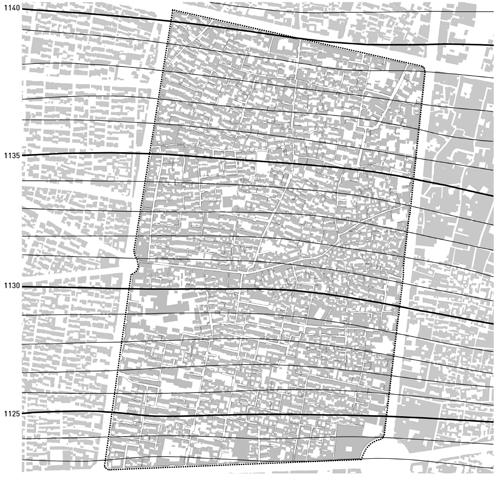
7 CONTEXT PHYSICAL CHARACTERISTICS Mixture of building types with different forms, styles, heights and materials can be seen in the images. (Dilapidated fabric vs new and tall buildings) Project Site 2017 Project Site 1956 SENSE OF PRIVACY Raising the walls of the yards in order to block the view from tall neighboring buildings allows women to take off their scarves and use the space easily and comfortably without being seen by strangers. Dilapidated Fabric Tehran

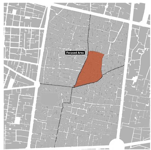
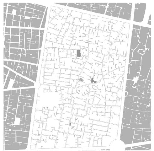
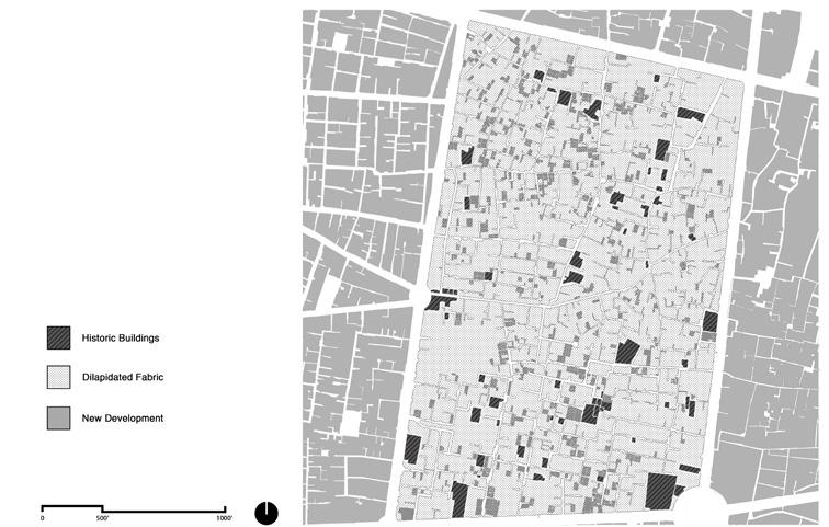
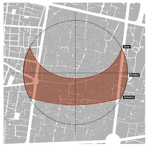
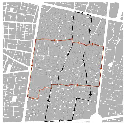

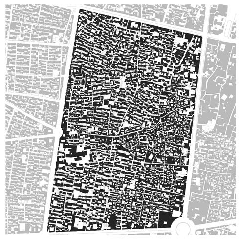
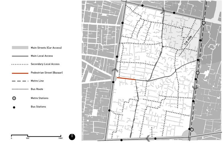
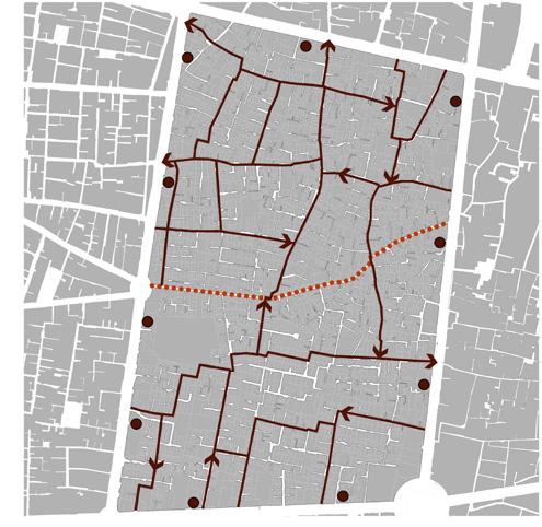
8 Access Pattern Topography Proposed Access Land Use Built Form Sun Path Proposed Local Public Transit Building Conditions Public Open Space Wind Direction Focused Area SITE ANALYSIS 7


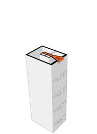
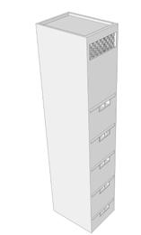
9 DESIGN STRATEGIES PROPOSED BUILDING REGULATION Changing the Hierarchy of Privacy PROPOSED BUILDING REGULATION Maintaining the Same Building Height to Width Ratio as the Historical Context 4-story Buildings around the Public Courtyards with Setback on the Top Floors Building Conditions 3-story Buildings along the Narrow s Setback on the Top Floors WIND-TOWER/STAIRCASE Possible Areas to Open up and Create Public Open Spaces 8

 All the Entrances are from the")

10 SITE PLAN OF THE FOCUSED AREA Showing the Distribution of the Public Courtyards and the Replacement of the Dilapidated Buildings with the New Building Typologies An Example of a Public Courtyard with a Cluster of Buildings with Different Parcel Sizes (Small, Medium and Large Parcel) All the Entrances are from the Public Courtyard. Number of New Dwelling Units around the Sample Courtyard = 22 Number of Existing Dwelling Units = 2 Total DU numbers= 24 Public Courtyard Area: 1000 sq-ft 9

11 SECTION THROUGH TWO PUBLIC COURTYARDS With the New Building Typologies around Them 10

12 Social Dimension: Public & Private / Sense of Privacy Climatic Features: Sun Light Climatic Features: Wind / Air Circulation Climatic Features: Surface Water Collection 11


13 Y > 40 ft BUILDING TYPOLOGIES TYPE A INDIVIDUAL SMALL PARCELS 3-Story Buildings No Subtraction from the Parcel for Public Open Spaces 2 Double Aspect Units One Unit on 1st Floor & a Two-Story Unit on 2nd and 3rd Floor Minimum 10 ft Setback on The 3rd Floor from the Minimum Area of a Loggia for Each Unit is 30 ft No Wind Tower TYPE B INDIVIDUAL MEDIUM PARCELS 3 to 4-Story Buildings (Depending to the Location of the Lot) The Maximum Subtraction from a Medium Parcel for Public Open Space is 20% Four DU Consists of Two-Story Single Aspect Units or One-Story Double Aspect Units Minimum 10 ft Setback on the 3rd Floor from the for 3-Story Buildings Minimum Area of a Loggia for Each Unit is 30 ft Wind Tower TYPE C LARGE PARCELS/ CONSOLIDATED PARCELS 4-Story Buildings The Maximum Subtraction from a Large Parcel for Public Open Space is 20% Eight to Ten DU Consists of Two-Story Single Aspect Units or One-Story Double Aspect Units Minimum Area of a Loggia for Each Unit is 30 ft Wind Tower One-story Double Aspect Unit X > 50 ft Parcel 10 ft X< 50 ft Parcel Y< 20 ft min 10 ft 2nd Unit (2 story-unit) X > 50 ft Parcel 40 >Y > 20 ft Two-story Single Aspect Unit Public Space Two-story Single Aspect Unit Public Space Two-story Single Aspect Unit One-story Double Aspect Unit X< 50 ft Parcel Y< 20 ft 10 ft basement 1st Unit min 10 ft X > 50 ft Parcel 40 >Y > 20 ft basement Parcel X > 50 ft Parcel Y > 40 ft basement basement Public Space Public Space Public Space Public Space 12


14 View to a Public Courtyard View to a Loggia (Sense of Privacy) 13
15 FINANCING MODEL CURRENT DEVELOPMENT MODEL The City Incentives (eg. permission for one more floor on consolidated lands) In this model, 5 to 6 story buildings were built mostly by outside investors in shared venture with land owners with a strong tendency towards consolidated parcels and based on a speculative development model. In this kind of development, feasibility is the primary concern. Private Developers Construction Cost Land Owners Land NEW PROPOSAL The City Low-rate Loan In this model, the land is provided by the land owners and the construction costs would be partly provided by the low-rate loan from the public sector and partly through the local community cooperative system. By doubling the number of the units, the land owners would have one unit to live and another to rent or sell, providing them with the money to pay back the loan. Moreover, the profit from the development would be distributed among the community. Cooperative Community s Share Construction Cost Land Owners Land 14
Nader Obied Abd al raheem hathat. Dr. Farid S. Al-Qeeq
 Submit from Nader Obied Abd al raheem hathat Submit to Dr. Farid S. Al-Qeeq DEC. 2010 NEW URBANISM : is the most important planning movement this century, which emerged during the late 1980s and early
Appendix C: Interim Mixed-Use Evaluation Criteria
 Appendix C: Interim Mixed-Use Evaluation Criteria C-1 Appendix C: Interim Mixed-Use Evaluation Criteria PURPOSE: The implementation of numerous policies contained within the Master Plan hinges on the creation
CNU CHARTER AWARDS 2018 ARGYLE SHARED STREET FACT SHEET
 CNU CHARTER AWARDS 2018 ARGYLE SHARED STREET FACT SHEET Submission Category: I. The Region: Metropolis, City and Town X II. Neighborhood, District and Corridor III. Block, Street and Building Best of title:
Official Plan Review
 Official Plan Review Summary Report - The Built Environment August 2014 Part 1: Introduction Planning for a healthy, prosperous and sustainable community is an important goal for our municipality. From
Status Update (2006 vs. Now) Citizen s Advisory Committee February Plan for Prosperity
 Citizen s Advisory Committee February Plan for Prosperity") Status Update (2006 vs. Now) Citizen s Advisory Committee February 2018 Plan for Prosperity 2000 2017 2000 2017 Gardnerville Population 6,000 5,760 5746 5,500 5,000 5,067 5,550 5,165 5,394 5,412 5,250
Status Update (2006 vs. Now) Citizen s Advisory Committee February 2018 Plan for Prosperity 2000 2017 2000 2017 Gardnerville Population 6,000 5,760 5746 5,500 5,000 5,067 5,550 5,165 5,394 5,412 5,250
Metro. Activity Center Design Guidelines. Recommendations For Developing Focused, Mixed-Use Commercial/Residential Centers
 Metro Activity Center Design Guidelines Recommendations For Developing Focused, Mixed-Use Commercial/Residential Centers Metro Activity Centers What is a MAC? Legacy, the adopted guide for the future growth
SECTION TWO: Overall Design Guidelines
 SECTION TWO: Overall Design Guidelines This section provides overall design principles and guidelines for the Gardnerville Mixed-use Overlay. They provide criteria for mixed-use places consisting of residential,
Policies and Code Intent Sections Related to Town Center
 Policies and Code Intent Sections Related to Town Center The Town Center Vision is scattered throughout the Comprehensive Plan, development code and the 1994 Town Center Plan. What follows are sections
Urban Design Manual PLANNING AROUND RAPID TRANSIT STATIONS (PARTS) Introduction. Station Study Areas
 Introduction. Station Study Areas") 111111 PLANNING AROUND RAPID TRANSIT STATIONS (PARTS) Introduction The ION rapid transit system will link Waterloo, Kitchener and Cambridge through a central transit corridor (CTC). There are a number
111111 PLANNING AROUND RAPID TRANSIT STATIONS (PARTS) Introduction The ION rapid transit system will link Waterloo, Kitchener and Cambridge through a central transit corridor (CTC). There are a number
FLORIN ROAD CORRIDOR Site Plan and Design Review Guidelines Checklist
 FLORIN ROAD CORRIDOR Site Plan and Design Review Guidelines Checklist Applicant s Name: Project Address: Phone: Email: Applicant shall fill out the design guidelines checklist for all guidelines applicable
(DC1) Direct Development Control Provision DC1 Area 4
 Direct Development Control Provision DC1 Area 4") . General Purpose (DC) Direct Development Control Provision DC Area 4 The purpose of this Provision is to provide for an area of commercial office employment and residential development in support of the
. General Purpose (DC) Direct Development Control Provision DC Area 4 The purpose of this Provision is to provide for an area of commercial office employment and residential development in support of the
B L A C K D I A M O N D D E S I G N G U I D E L I N E S for Multi-family Development
 B L A C K D I A M O N D D E S I G N G U I D E L I N E S for Multi-family Development Adopted June 18, 2009 This section of the Design and focuses on site planning and design guidance for new multi-family
FRUITVALE TRANSIT VILLAGE (Phase 2) Residential Project
 Residential Project") FRUITVALE TRANSIT VILLAGE (Phase 2) Residential Project DEVELOPER: SIGNATURE PROPERTIES ARCHITECT: HKIT ARCHITECTS April 23, 2010 TABLE OF CONTENTS 3 Vision 4 Description of Site 5 Guiding Concepts 6
FRUITVALE TRANSIT VILLAGE (Phase 2) Residential Project DEVELOPER: SIGNATURE PROPERTIES ARCHITECT: HKIT ARCHITECTS April 23, 2010 TABLE OF CONTENTS 3 Vision 4 Description of Site 5 Guiding Concepts 6
2040 LUP is a part of the Comprehensive Plan and carries the same legal authority. Economic Challenges
 1.1. Guiding Anchorage s Growth Where will new residents settle over the next two decades? Where will people work, shop, and play? Will there be enough room to grow? How will Anchorage look? Will growth
EXISTING COMPREHENSIVE PLAN
 EXISTING COMPREHENSIVE PLAN Town Center Land Use Element: V. LAND USE POLICIES Town Center Mercer Island's business district vision as described in "Your Mercer Island Citizen-Designed Downtown" was an
Bourne Downtown Site Planning
 Prepared for: The Town of Bourne, MA In Cooperation with: Bourne Financial Development Corporation Prepared by:, Inc. June 24, 2009 Table of Contents Introduction and Summary... 1 Site Existing Conditions...
THE POLICY FRAMEWORK FOR WALKABLE COMMUNITIES. Community Technical Assistance Program Building Active Communities Institute March 2016
 THE POLICY FRAMEWORK FOR WALKABLE COMMUNITIES Community Technical Assistance Program Building Active Communities Institute March 2016 ACTIVE COMMUNITIES BACK THEN ACTIVE COMMUNITIES BACK THEN Lifestyle
Lehigh Acres Land Development Regulations Community Planning Project
 Lehigh Acres Land Development Regulations Planning Effort Summary In July, 2010 Commissioner Frank Mann invited the Lehigh Acres community to start discussing how to achieve their recently adopted community
ALBEMARLE COUNTY CODE CHAPTER 18 ZONING SECTION 20A NEIGHBORHOOD MODEL - NMD
 CHAPTER 18 ZONING SECTION 20A NEIGHBORHOOD MODEL - NMD Sections: 20A.1 PURPOSE AND INTENT 20A.2 STATUS AS A PLANNED DEVELOPMENT DISTRICT 20A.5 CODES OF DEVELOPMENT 20A.6 PERMITTED USES 20A.7 RESIDENTIAL
Highland Village Green Design Guidelines
 Highland Village Green Design Guidelines Publishing Information Title Highland Village Green Design Guidelins Author The City of Calgary Status DRAFT - Proposed document subject to changes Additional Copies
CHAPTER 5: GUIDING PRINCIPLES
 CHAPTER 5: GUIDING PRINCIPLES The following 10 principles were developed based on public consultation, planning policy and the background analysis conducted during Phase 1. The Guiding Principles significantly
CHAPTER 12 IMPLEMENTATION
 CHAPTER 12 IMPLEMENTATION The 2010 Town of Denton Comprehensive Plan is intended to capture a vision of the future of Denton. As such, it provides a basis for a wide variety of public and private actions
DRAFT Land Use Chapter
 Stevens Creek Urban Village DRAFT 1 18 17 Land Use Chapter INTRODUCTION This Land Use Chapter describes how the Stevens Creek Urban Village will accommodate the growth that is planned for it in the Envision
ARTICLE 6: Special and Planned Development Districts
 ARTICLE 6: Special and Planned Development Districts 6-10 Traditional Neighborhood Development (TND) District 6-10.10 Purpose and Intent The Traditional Neighborhood Development (TND) District provides
LOW DENSITY RESIDENTIAL
 LOW DENSITY RESIDENTIAL Corner lots with coach houses to increase diversity, provide unity to the streetscape and increase eyes on the street. Garages and ancillary units accessed via rear lanes. Parking
4.0 Design Guidelines For The Village Centre. South fields Community Architectural Design Guidelines Town of Caledon
 4.0 Design Guidelines For The Village Centre 4.0 Design Guidelines for the Village Centre The Village Centre is the focal point of the entire South Fields Community and is designed as a traditional commercial
2.0 Strategic Context 4
 2.0 Strategic Context 4 2.1 The Area Action Plan is a non-statutory plan, which forms a corporate policy document, expressing particular issues and areas of concern while also providing a vision for the
TRANSIT ORIENTED DEVELOPMENT PINELLAS COUNTY MPO LIVABLE COMMUNITIES INITIATIVE PINELLAS COUNTY COMPREHENSIVE PLAN AMENDMENTS
 PINELLAS COUNTY MPO LIVABLE COMMUNITIES INITIATIVE MODEL LAND DEVELOPMENT CODE TRANSIT ORIENTED DEVELOPMENT PINELLAS COUNTY COMPREHENSIVE PLAN AMENDMENTS MPO Livable Communities Initiative Goal: Improve
Public Open House. Overview of the Downtown Plan Official Plan Amendment April 23, 2018
 Public Open House Overview of the Downtown Plan Official Plan Amendment April 23, 2018 1 A 25-Year Plan for Downtown To ensure growth contributes positively to Toronto s Downtown as a great place to live,
Infill Residential Design Guidelines
 Infill Residential Design Guidelines Adopted March 23, 2004 Amended September 10, 2013 City of Orange Community Development Department Planning Division Phone: (714) 744-7220 Fax: (714) 744-7222 www.cityoforange.org
Forest Hills Improvement Initiative A Partnership for Building a Better Community. Use & Design Guidelines September 23, 2008
 Forest Hills Improvement Initiative A Partnership for Building a Better Community City of Boston Thomas M. Menino, Mayor Emerging Community Vision p. 2 Site Use & Design Guidelines p. 3 to 21 Arborway
II. SINGLE FAMILY RESIDENTIAL
 II. SINGLE FAMILY RESIDENTIAL Castle Rock is made up of numerous individually built houses and subdivision tracts that have been developed during the past century. Some of the tracts are diverse in architectural
Chapter 4. Linking Land Use with Transportation. Chapter 4
 Chapter 4 Linking Land Use with Transportation Chapter 4 59 Chapter 4 Linking Land Use with Transportation Community Design and Transportation Program Introduction Since the 1950s, the predominant development
ELMVALE ACRES SHOPPING CENTRE MASTER PLAN
 ELMVALE ACRES SHOPPING CENTRE MASTER PLAN Contents 1.0 INTRODUCTION... 2 2.0 LOCATION... 2 3.0 EXISTING CONTEXT... 2 4.0 VISION & GUIDING PRINCIPLES... 2 5.0 LAND USE AND BUILT FORM... 4 5.1 St. Laurent
The Five Components of the McLoughlin Area Plan
 The Five Components of the McLoughlin Area Plan This documents contains the complete language of the five components of the McLoughlin Area Plan: The Vision Statement The Values The Guiding Principles
3.1 community vision. 3.3 required plan elements
 Chapter 3 Community Form 3.1 community vision 3.2 Parks & landscaping concepts 3.3 required plan elements D R A F T 20 Community Form Chapter 3 3.0 Community form 3.1 community vision The Specific Plan
Hockessin Community Redevelopment Plan
 Hockessin Community Redevelopment Plan 3.1 Introduction The Community Redevelopment Plan for the Village of Hockessin is the result of the people s vision for a distinct village center that serves as the
GUIDING PRINCIPLES IN THIS CHAPTER
 GUIDING PRINCIPLES The guiding principles and design concepts in this chapter work together with the Chapel Hill 2020 Comprehensive Plan to support new public places that can be enjoyed by all while also
Behnke Ranch Property, Pasco County: Master Plan Development Approach
 February 24, 2014 , Pasco County: Master Plan Development Approach Location & Program The (Legacy PUD) is located in southwest Pasco County along State Road 54 approximately 1.5 miles west of the Suncoast
Historic Preservation Preserve, restore or adaptively re-use historic structures and landscapes.
 Checklist for New Construction Developers of building projects in the Loring Park Neighborhood are encouraged to pursue the standards that are identified below. For large projects requiring special allowances,
Gold Line Bus Rapid Transit Transit Oriented Development (BRTOD) Helmo Station Area Plan
 Helmo Station Area Plan") Appendix F Gold Line Bus Rapid Transit Transit Oriented Development (BRTOD) Helmo Station Area Plan Introduction and Purpose of the Plan The Gold Line Bus Rapid Transit facility is an eleven-mile dedicated
Appendix F Gold Line Bus Rapid Transit Transit Oriented Development (BRTOD) Helmo Station Area Plan Introduction and Purpose of the Plan The Gold Line Bus Rapid Transit facility is an eleven-mile dedicated
FUTURE LAND USE ELEMENT
 FUTURE LAND USE ELEMENT GOAL I: To create and sustain a great place to live, play, and prosper Objective 1: The City of Ocala shall incorporate the principles and strategies of the Ocala 2035 Vision into
CHAPTER 6: Community Design and Appearance
 AGLE AREA COMMUNITY Plan CHAPTER 6 CHAPTER 6: Community Design and Appearance Community Design and Appearance How a community is designed and what a community looks like are attributes fundamental to the
MALL REVITALIZATION CASE STUDIES
 MALL REVITALIZATION CASE STUDIES DECEMBER 9, 2012 MALL REVITALIZATION OVERVIEW Introduction Sample Case Studies prepared for Lacey Woodland District Steering Committee as it considers strategies to revitalize
6. BUILDINGS AND SPACES OF HUMAN SCALE
 The Neighborhood Model: Building Block for the Development Areas Design Approaches 79 6. BUILDINGS AND SPACES OF HUMAN SCALE There are many elements of buildings and spaces that contribute to the creation
Westbound: A One-day Exploration of Growth
 Westbound: A One-day Exploration of Growth Frog Pond Area 2018 UGB Expansion Proposal June 13, 2018 Growing Out: UGB Asks Four cities submitted proposals to expand greater Portland s urban footprint by
SECTION TWO: Urban Design Concepts
 SECTION TWO: Urban Design Concepts The Gardnerville Plan for Prosperity shapes economic opportunities presented by regional growth. The Urban Design Concepts provide policies and concepts for land use,
Plano Tomorrow Vision and Policies
 Plano Tomorrow Vision and Policies PLANO TOMORROW PILLARS The Built Environment The Social Environment The Natural Environment The Economic Environment Land Use and Urban Design Transportation Housing
Buildings may be set back to create small plazas provided that these setbacks do not substantially disrupt the street wall s continuity.
 6-22 Community Design Street Walls and Street-front Setbacks The siting of buildings will play a critical role in establishing the character and sense of place for the District. Siting buildings at the
Town Center (part of the Comprehensive Plan)
") Town Center (part of the Comprehensive Plan) Mercer Island Town Center Looking North (2014) In 1994, a year-long process culminated in a set of design guidelines and code requirements for the Town Center
Town Center (part of the Comprehensive Plan) Mercer Island Town Center Looking North (2014) In 1994, a year-long process culminated in a set of design guidelines and code requirements for the Town Center
The Interlace. Winner Urban Habitat Award. Singapore
 190 Winner Urban Habitat Award The Interlace Singapore It is difficult to think of a more appropriate winner for the inaugural Urban Habitat Award than The Interlace. The project demonstrates brilliantly
V. Vision and Guiding Principles
 V. Vision and Guiding Principles The Master Plan for the Powers Ferry Corridor seeks a foundation in the desires of the community. At times, various elements of the community offered opposing viewpoints,
Transit-Oriented Development
 Transit-Oriented Development Path to Sustainability West Windsor February 22, 2007 George S. Hawkins Context for Presentation NJ Future is a non-partisan, 501(c)3 non-profit organization. Offer perspective,
Master Zoning Plan for the Northeast Property. in El Paso, Texas. Approved August Master Zoning Plan for the Northeast Property. City of.
 El Paso, Texas in El Paso, Texas Prepared for: City of Prepared by: Texas Kimley-Horn and Associates, Inc. 12700 Park Central Drive Suite 1800 Dallas, Texas 75251 Tel: (972) 770-1300 Approved August 2008
Danvers High Street I-1 District Study
 Danvers High Street I-1 District Study Presentation of Final Recommendations Planning Board Presentation June 26 th, 2018 1 Introductions Metropolitan Area Planning Council Sam Cleaves AICP, Principal
TUSTIN RED HILL DEVELOPMENT TUSTIN CITY COUNCIL WORKSHOP
 TUSTIN RED HILL DEVELOPMENT TUSTIN CITY COUNCIL WORKSHOP 7-6-15 CONTEXT MAP PREVIOUS CHURCH AND ADJACENT RETAIL SITE EXISTING RETAIL CENTER SITE CONDITIONS PREVIOUS SITE CONDITIONS PREVIOUSLY APPROVED
Subregion 4 Central Avenue-Metro Blue Line Corridor Transit-Oriented Development (TOD) Implementation Project. Community Meeting April 27, 2011
 Implementation Project. Community Meeting April 27, 2011") Subregion 4 Central Avenue-Metro Blue Line Corridor Transit-Oriented Development (TOD) Implementation Project Community Meeting April 27, 2011 Overview Introduction to Subregion 4 TOD Implementation Program
Subregion 4 Central Avenue-Metro Blue Line Corridor Transit-Oriented Development (TOD) Implementation Project Community Meeting April 27, 2011 Overview Introduction to Subregion 4 TOD Implementation Program
FUTURE LAND USE PLAN 7
 FUTURE LAND USE PLAN 7 The recommendations of each of the preceding chapters can be combined to present an overall Future Land Use Plan for Wilton. The Future Land Use Plan, presented on the following
Shifting Paradigms Urban Planning and Town Center Development in the United States
 Timothy H. Haahs PE, AIA April 20, 2010 Shifting Paradigms Urban Planning and Town Center Development in the United States Urban Life "The street is the river of life." Trends / 국민일보 2010 년 3 월 1 일자발췌
WEST LOOP DESIGN GUIDELINES CHECKLIST
 WEST LOOP DESIGN GUIDELINES CHECKLIST Section 1.0 General Strategies 1.1 DESIGN EXCELLENCE: ENCOURAGE HIGH QUALITY AND INNOVATIVE DESIGN OF NEW BUILDINGS WITHIN THE WEST LOOP WITHOUT BEING PRESCRIPTIVE
Welcome to the Oakridge Centre Open House
 Welcome to the Oakridge Centre Open House Why is the City hosting this event? This open house is to inform you of a rezoning application submitted to the City of Vancouver to amend the existing CD-1 (Comprehensive
CENTRAL CITY NEIGHBORHOOD Site Plan and Design Review Guidelines Checklist
 Applicant s Name: Project Address: NEIGHBORHOOD Phone: Email: Applicant shall fill out the design guidelines checklist for all guidelines applicable to the project. Check the box if meets guideline. Indicate
Former Rockcliffe Airbase Community Design Plan Guiding Design Vision and Principles December 4, 2013
 APPENDIX 5 - Guiding Design Vision and Principles Former Rockcliffe Airbase Community Design Plan Guiding Design Vision and Principles December 4, 2013 Vision Statement The redevelopment of the former
Derry Green Corporate Business Park
 Town of Milton Derry Green Corporate Business Park Urban Design Guidelines BMI/Pace - June 2010 Draft 3 Prepared by: Brook McIlroy Planning + Urban Design / Pace Architects Suite 300-51 Camden Street Toronto,
3.0 URBAN DESIGN. December 6, OVERVIEW
 Urban Design 3.0 URBAN DESIGN December 6, 2007 3.1 OVERVIEW The highly urban character of Easton Place is defined by the overall design of the community. The following sections provide an overview of the
K. SMART ASSOCIATES LIMITED
 Planning Justification Report Zoning By-Law Amendment 185 King Street North Waterloo, Ontario April 7th, 2017 Project Reference Number 16-245 K. SMART ASSOCIATES LIMITED CONSULTING ENGINEERS AND PLANNERS
PUBLIC RIGHT-OF-WAY IN THIS CHAPTER PUBLIC REALM
 PUBLIC RIGHT-OF-WAY This section provides design guidelines for improvements in the public right-of-way. The public right-of-way refers to streets, sidewalks, non-vehicular thoroughfares, parks and greenways
Cumberland Region Tomorrow is a private, non-profit, citizen based regional organization working with Greater Nashville Regional Council
 Cumberland Region Tomorrow is a private, non-profit, citizen based regional organization working with Greater Nashville Regional Council and others in the public and private sectors, dedicated to planning
APPENDIX D: BACKGROUND AND VISION
 APPENDIX D: BACKGROUND AND VISION BACKGROUND A. Specific Plan Location Jordan Downs is located at 9800 Grape Street in Los Angeles, California, 90002. The Jordan Downs Urban Village Specific Plan area
Chapter 6--Urban Design
 6.1 Introduction... 6-1 6.1.1 Background & Scope... 6-1 6.1.2 Relationship to State Law... 6-2 6.1.3 Relationship to Other General Plan Chapters... 6-2 6.2 Guiding Principles... 6-2 6.3 Urban Design Guidelines...
City of Heath. Town Center Concept
 In the give-and-take of getting projects designed, financed, and approved, the famous refrain from the film Field of Dreams is heard often: if you build it, they will come. From the perspective of the
TALL BUILDING GUIDELINES
 TALL BUILDING GUIDELINES Urban Design Guidance for the Site Planning and Design of Tall Buildings in Milton May, 2018 A Place of Possibility Contents 1.0 INTRODUCTION 1 1.1 What is a Tall Building? 2
Visioning Statement and Guiding Principles
 Visioning Statement and Guiding Principles Planning for the Future The General Plan The General Plan represents Woodland's shared vision of the future and defines a path to lead the community toward its
4.0 URBAN DESIGN FRAMEWORK. The vision for the future development of the plan area is to:
 4.0 The vision for the future development of the plan area is to: Create a new neighbourhood that focuses on the highly valued natural and aesthetic features of the lands and provides good quality homes,
III. Design Principles
 III. Design Principles The design of Bay Meadows Phase II has been guided by a series of Urban Design Principles. These principles, informed by consultant site analysis, City staff recommendations, and
SITE PLAN AREA. Met Park 6 Site Area (122,368 sf) Met Park 4/5 The Bartlett. Met Park 3 The Acadia. Met Park 2 The Millennium.
 Met Park 4/5 The Bartlett. Met Park 3 The Acadia. Met Park 2 The Millennium.") SITE PLAN AREA Met Park 4/5 The Bartlett Met Park 3 The Acadia Met Park 2 The Millennium Met Park 6 Site Area (122,368 sf) Met Park 1 The Gramercy Met Park 7 and 8 2 SUBJECT SITE Existing Use: Pentagon
SITE PLAN AREA Met Park 4/5 The Bartlett Met Park 3 The Acadia Met Park 2 The Millennium Met Park 6 Site Area (122,368 sf) Met Park 1 The Gramercy Met Park 7 and 8 2 SUBJECT SITE Existing Use: Pentagon
CHAPTER 7: VISION AND ACTION STATEMENTS. Noble 2025 Vision Statement
 CHAPTER 7: VISION AND ACTION STATEMENTS This chapter presents the vision, policy and action statements that transform the comprehensive planning study, an analysis of Noble s past, future trends and community
Planned Residential Neighborhoods Land Use Goals
 Planned Residential Neighborhoods Land Use Goals Issue: Guidelines that provide for diverse high quality residential areas that include a variety of housing styles and layouts are needed. Goal 1: Create
CONTENTS 8.0 LAND USE 8.1 GENERAL LAND USE 8.2 RESIDENTIAL 8.3 MIXED USE 8.4 COMMERCIAL 8.5 EMPLOYMENT LANDS
 8-2 Land Use 8.0 LAND USE CONTENTS 8.1 GENERAL LAND USE 8.1.1 Uses provided for in all Land Use Designations 8.1.2 Uses prohibited in Hazardous Lands, Hazardous Sites and Special Policy Areas 8.1.3 Uses
4.1.3 LAND USE CATEGORIES
 4.1.3 LAND USE CATEGORIES a. City Center District The City Center District incorporates the existing character and mix of uses in downtown Belmont to encourage redevelopment and new development in keeping
Draft for Public Review. The Market and Octavia Neighborhood Plan
 Draft for Public Review The Market and Octavia Neighborhood Plan San Francisco Planning Department As Part of the Better Neighborhoods Program December 2002 IOverview Why Plan a Better Neighborhood Here
FUNDAMENTAL BUILDING BLOCKS
 FUNDAMENTAL BUILDING BLOCKS THE WEB OF GIBSONS - EXISTING Lacks Community Structure and Support Circulation, surface water flow and buildings are disjointed from the community Social neighbourhoods are
Joint Meeting City Council and the Plan Commission. September 1st, 2015
 Joint Meeting City Council and the Plan Commission September 1st, 2015 1 The City Plan Commission shall recommend a City Plan for the physical development of the City Article IX Section 2 of the City of
PSRC REVIEW REPORT & CERTIFICATION RECOMMENDATION
 PSRC REVIEW REPORT & CERTIFICATION RECOMMENDATION KITSAP COUNTY COUNTYWIDE PLANNING POLICIES July 2, 2012 BACKGROUND A major emphasis of the Washington State Growth Management Act (GMA) is the need to
Concord Community Reuse Project Goals and Guiding Principles. Overarching Goals (OG)
") Concord Community Reuse Project Goals and Guiding Principles Overarching Goals (OG) No priority is implied by the order of presentation of the goals and guiding principles. Overarching goals for the Concord
Concord Community Reuse Project Goals and Guiding Principles Overarching Goals (OG) No priority is implied by the order of presentation of the goals and guiding principles. Overarching goals for the Concord
Chapter 2: OUTLINE PLANNING APPLICATION PROPOSALS. A New Garden Neighbourhood Matford Barton 17
 Chapter 2: OUTLINE PLANNING APPLICATION PROPOSALS A New Garden Neighbourhood Matford Barton 17 2.1. SUMMARY AND STATUS OF THE PROPOSALS 2.1.1. The parameter plans and associated wording in this chapter
Citizen Comment Staff Response Staff Recommended Revision Planning Committee
 Citizen Comment Staff Response Staff Recommended Revision Planning Committee Area No. 1: Owner desires retail land uses. Area No. 1a: Owner of two small parcels adjacent to Area No. 1 desires retail land
4- PA - LD - LIVELY DOWNTOWN. LD - Background
 4- PA - LD - LIVELY DOWNTOWN LD - Background The downtown has been the service centre for the community since the city s inception and the area continues to supply people with their personal services,
REDLANDS TRANSIT VILLAGES SPECIFIC PLAN
 REDLANDS TRANSIT VILLAGES SPECIFIC PLAN CITY COUNCIL STUDY SESSION JANUARY 4, 2019 Redlands Blvd. Eureka St. Orange St. State St. Citrus Ave. Vine St. GENERAL PLAN TRANSIT VILLAGES WE ARE HERE SPECIFIC
YONGE STEELES CORRIDOR SECONDARY PLAN. Young + Wright / IBI Group Architects Dillon Consulting Ltd. GHK International (Canada) Ltd.
 Ltd.") PART A: PREAMBLE 1.0 PURPOSE The purpose of this Secondary Plan is to provide a development framework for intensification of the Yonge/ Steeles corridor including the north side of Steeles Avenue West
PART A: PREAMBLE 1.0 PURPOSE The purpose of this Secondary Plan is to provide a development framework for intensification of the Yonge/ Steeles corridor including the north side of Steeles Avenue West
What s in a Name Sustainability, Smart Growth, New Urbanism
 What s in a Name Sustainability, Smart Growth, New Urbanism Published in the Summer 2011 Issue of APA s The Commissioner Pete Pointner FAICP Planning commissioners frequently hear abstract terms bantered
City of Woodinville Planning Commission Study Session. Development Regulations 101: An Overview of Specific Regulatory Items To Help You in 2012
 City of Woodinville Planning Commission Study Session Development Regulations 101: An Overview of Specific Regulatory Items To Help You in 2012 Development Regulations 101 Overview of the Different Zones
New Street Proposed Redevelopment Architecture & Urban Design Brief
 2130 2136 New Street Proposed Redevelopment Architecture & Urban Design Brief Prepared By: Cynthia Zahoruk Architect Inc. 3077 New Street, Burlington, ON, L7N 1M6 TABLE OF CONTENTS Background and Objective
EXHIBIT A. Tax Increment Reinvestment Zone No. 1 (Town Center) First Amended Project Plan 1
 First Amended Project Plan 1") EXHIBIT A Tax Increment Reinvestment Zone No. 1 (Town Center) First Amended Project Plan 1 1 As amended by Resolution No. 2008-02-001(TR1R) of the Tax Increment Reinvestment Zone No.1, and approved to
EXHIBIT A Tax Increment Reinvestment Zone No. 1 (Town Center) First Amended Project Plan 1 1 As amended by Resolution No. 2008-02-001(TR1R) of the Tax Increment Reinvestment Zone No.1, and approved to
Be it enacted by the Town Board of the Town of Guilderland that the following new A (Transit Oriented Development (TOD) District) is adopted:
 District) is adopted:") Local Law No. 4 of 2018 (Adoption of 280-18A (Transit Oriented Development District) Be it enacted by the Town Board of the Town of Guilderland that the following new 280-18A (Transit Oriented Development
Local Law No. 4 of 2018 (Adoption of 280-18A (Transit Oriented Development District) Be it enacted by the Town Board of the Town of Guilderland that the following new 280-18A (Transit Oriented Development
Chapter 5 Urban Design and Public Realm
 5.1 Introduction Public realm is all areas of the urban fabric to which the public have access. It is where physical interaction takes place between people. It therefore, includes buildings and their design,
SECTION II SECTION II STATEMENT OF GOALS, OBJECTIVES, PRINCIPLES, ASSUMPTIONS, POLICIES AND STANDARDS
 STATEMENT OF GOALS, OBJECTIVES, PRINCIPLES, ASSUMPTIONS, POLICIES AND STANDARDS 1 2 STATEMENT OF GOALS, OBJECTIVES, PRINCIPLES, ASSUMPTIONS, POLICIES AND STANDARDS INTRODUCTION The New Jersey Municipal
Cambie Corridor Planning Program Phase Two Draft Plan. Standing Committee on City Services and Budgets May 5, 2011
 Cambie Corridor Planning Program Phase Two Draft Plan Standing Committee on City Services and Budgets May 5, 2011 Cambie Corridor Program Terms of Reference approved July 2009 Land Use Transportation Energy
6 PORT SYDNEY SETTLEMENT AREA
 Section 6 Port Sydney Page 61 6 PORT SYDNEY SETTLEMENT AREA 6.1 Basis and Principles Village of Port Sydney Waterfront Community Existing Services 6.1.1 Port Sydney is an historic settlement that has developed
CITY OF UNION CITY MINUTES GENERAL PLAN ADVISORY COMMITTEE
 CITY OF UNION CITY MINUTES GENERAL PLAN ADVISORY COMMITTEE WEDNESDAY, MARCH 4, 2015, 6:30 P.M. IN THE CITY COUNCIL CONFERENCE ROOM OF CITY HALL 34009 ALVARADO-NILES BLVD., UNION CITY, CALIFORNIA Attachment