Landscape Conservation Design June, 2014
|
|
|
- Angela Elfreda Small
- 5 years ago
- Views:
Transcription


1 Designing Sustainable Landscapes in the Northeast A project of the North Atlantic Landscape Conservation Cooperative & Northeast Climate Science Center June, 2014


2 Adaptive Establish Conservation Goals & Objectives Adjust ConNet Evaluate ConNet Ecological Socio-cultural Economic Monitor ConNet Design ConNet Implement ConNet

3 Design Steps: Current focus 1. Select (tiered) core areas 2. Create core area buffers 3. Prioritize within buffered cores 4. Assess connectivity among cores 5. Prioritize among core areas 6. Prioritize among linkages 7. Prioritize within linkages 8. Identify restoration opportunities 9. Determine management needs Field verification at all steps Socio-cultural and economic considerations at all steps
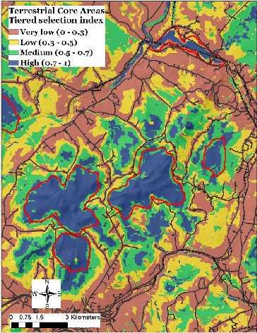
4 1. Select (tiered) core areas Three scenarios: Ecosystem approach (coarse filter) based solely on ecosystem conditions Species approach based solely on focal species considerations Combined ecosystem-species approach based on the complement of ecosystems and species
5 Q1. TNC resiliency vs DSL IEI?
6 Landscape Assessment Ecological integrity Ecological integrity is a multi-faceted and multi-scale concept comprised of several inter-related components that operate at multiple scales (in space and time) Ecological integrity refers to the capability of an area to sustain ecological functions; in particular, the ability to support biodiversity and the ecosystem processes necessary to sustain biodiversity over the short and long term, especially in the face of disturbance and stress.
7 Landscape Assessment Local ecological integrity An integral site is intact, highly connected and resilient Intactness refers to the freedom from human impairment (anthropogenic stressors) Connectivity refers to the propensity to conduct ecological flows (including individuals) across the landscape Resiliency refers to the capacity to recover from or adapt to disturbance and stress
8 Landscape Assessment Local ecological integrity Resiliency is a complex, multi-faceted concept comprised of several inter-related components that operate at multiple scales (in space and time) Similarity refers to the ecological similarity of the neighborhood Connectedness refers to the ecological similarity and accessibility of the neighborhood Ecosystem diversity refers to the ecological diversity of the neighborhood Adaptive capacity refers to the ecological diversity and accessibility of the neighborhood Short term Long term


9 Landscape Assessment Local ecological integrity An integral site is intact, highly connected and resilient Resiliency Local Integrity Intactness Stressors Short term Similarity Connectedness Long term Ecosystem diversity Adaptive capacity TNC Connectivity IEI* *current version
10 Q1. TNC resiliency vs DSL IEI? Technical comparison Components: Landscape complexity: f(landform variety, elevation variability, wetland density), 30 m resolution Connectedness: static, natural vs developed, 90m resolution Components: Stressor metrics: 19 metrics, terrestrial vs aquatic, kernels, 30 m resolution Similarity Connectedness: dynamic, unique settings, 30m resolution

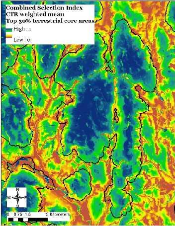
11 Q1. TNC resiliency vs DSL IEI? Scaling of index 26 classes in CTR; 1000 acre hexagons 44 macrogroups in CTR; 30m cells
12 Q1. TNC resiliency vs DSL IEI? TNC resiliency emphasizes connectivity with diverse geophysical settings DSL IEI emphasizes intactness and connectivity with similar ecological settings TNC resiliency is scaled by coarse-grained geophysical settings (geology and elevation) DSL IEI is scale by fine-grained ecological systems (macrogroup level)


13 Q1. TNC resiliency vs DSL IEI? Scaling of index

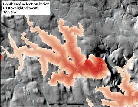
14 Q2. What does the Top x% mean?

15 Q2. What does the Top x% mean?
16 Q2. What does the Top x% mean?
17 Q3. Tradeoffs between slice and algorithmic approach?

18 Q3. Tradeoffs between slice and algorithmic approach?

19 Q4. Best way to ensure distribution of core areas?

20 Q4. Best way to ensure distribution of core areas?

21 Q5. Display of aquatic vs. terrestrial buffered cores?
22 Q5. Display of aquatic vs. terrestrial buffered cores?
23 Q6. Tiered vs. continuous matrix?

24 Q6. Tiered vs. continuous matrix?
25 Q7. Terminology?

26 Design Steps: 1. Select (tiered) core areas 2. Create core area buffers 3. Prioritize within buffered cores 4. Assess connectivity among cores 5. Prioritize among core areas Current 6. Prioritize among linkages focus 7. Prioritize within linkages 8. Identify restoration opportunities 9. Determine management needs Field verification at all steps Socio-cultural and economic considerations at all steps

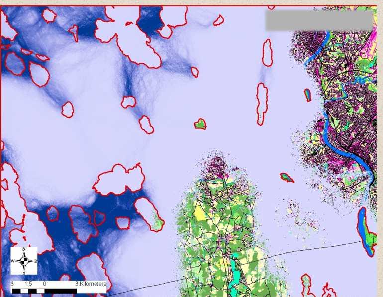
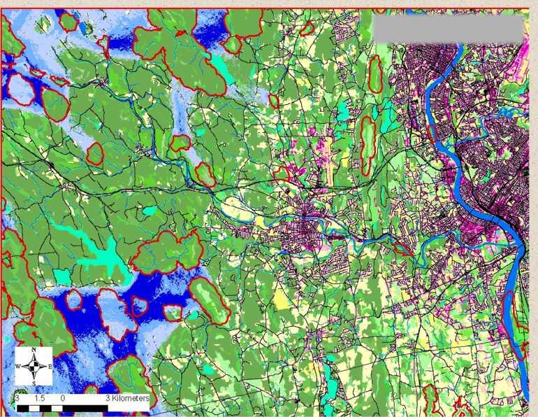
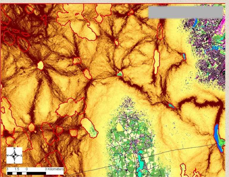
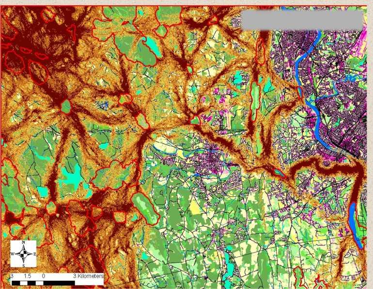
27 4. Assess connectivity among terrestrial core areas


28 4. Assess connectivity among core areas a) Build random low cost paths between cores
 of the")
29 5. Prioritize among core areas Node importance index Based on node contribution to the probability of connectivity (PC) of the network
30 6. Prioritize among linkages Link importance index Based on link contribution to the probability of connectivity (PC) of the network
 of the")
31 6. Prioritize among linkages Link importance index Based on link contribution to the probability of connectivity (PC) of the network
32 7. Prioritize within linkages Conductance index Irreplaceability index Vulnerability index Relative probability of flow through a call (function of local resistance, node size, quality and proximity)
33 7. Prioritize within linkages Conductance index Irreplaceability index Vulnerability index Relative concentration of paths through a call (function of local resistance and path irreplaceability)

34 7. Prioritize within linkages Conductance index Irreplaceability index Vulnerability index Relative probability of developing an irreplaceable cells that has a high relative probability of use Under Development

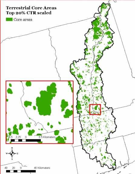
35 Core areas
36 Conductance
37 Conductance
38 Irreplaceability
39 Irreplaceability
40 Combined
41 Vulnerability*
 Best on Route 7 between Best 20 in MA Mount Greylock and")
42 8. Identify restoration opportunities Road passage structures Road-stream crossings Dams Wetland/forest restoration (phase 3) Best on Route 7 between Best 20 in MA Mount Greylock and Brodie Mountain

43 8. Identify restoration opportunities Road passage structures Road-stream crossings Dams Wetland/forest restoration (phase 3)

44 8. Identify restoration opportunities Road passage structures Road-stream crossings Dams Wetland/forest restoration (phase 3)


45 9. Determine management needs (and prioritize within core areas, buffers and corridors) Are there habitat management needs for particular species? If so, what are they and where should they occur? Is this best handled outside of the conservation design??
 Size and configuration (min size; fewer larger vs more smaller)? c) Spread barriers?")
 What spatial units to use? b) What method for delineating buffers? 3. How much area to allocate to buffer-cores?")
46 Key Decisions: 1. Terrestrial buffer-core area selection and delineation a) Slice or algorithmic approach? b) Size and configuration (min size; fewer larger vs more smaller)? c) Spread barriers? d) CTR vs HUC8 (or other) scaling? 2. Aquatic buffer-core area selection and delineation? a) What spatial units to use? b) What method for delineating buffers? 3. How much area to allocate to buffer-cores? 4. What s the best way to display the core area results?


47 For More Information Project website: Feedback: Manager online survey Links to products: Overview Technical docs Presentations Results Personal contact: eco.umass.edu
Landscape Conservation Design April, 2014
 Designing Sustainable Landscapes in the Northeast A project of the North Atlantic Landscape Conservation Cooperative & Northeast Climate Science Center Landscape Conservation Design April, 2014 Conceptual
I ll be talking about the Designing Sustainable Landscapes project today. This is a large integrated modeling effort our group at UMass has been
 1 I ll be talking about the Designing Sustainable Landscapes project today. This is a large integrated modeling effort our group at UMass has been working on for the past 5 years, in close collaboration
Aquatic, Terrestrial and Landscape Conservation Design Tools and Products of the North Atlantic LCC
 Aquatic, Terrestrial and Landscape Conservation Design Tools and Products of the North Atlantic LCC Scott Schwenk Science Coordinator, North Atlantic LCC Chesapeake Bay FWS Partners Meeting Annapolis,
Making Data Work for You: Free Mapping Tools for Prioritization and Property Research
 Making Data Work for You: Free Mapping Tools for Prioritization and Property Research Ariel Maiorano amaiorano@massaudubon.org Abby Hardy-Moss abby@ecga.org Essex County Open Space Conference March 25,
Landscape Ecology and Amphibians
 and Amphibians WFS 533 Wyn Miller March 26, 2009 Overview Introduction to landscape ecology Metapopulation dynamics Natural habitat fragmentation Anthropogenic habitat fragmentation landscape ecology Introduction
Great Lakes Conservation Blueprint for Terrestrial Biodiversity on the Canadian Shield
 Great Lakes Conservation Blueprint for Terrestrial Biodiversity on the Canadian Shield Bonnie L. Henson 1, Kara E. Brodribb 2 and John L. Riley 3 1 Ontario Ministry of Natural Resources 2,3 The Nature
Consequences of Landscape Patterns on Flows of Energy, Nutrients, Organisms
 Consequences of Landscape Patterns on Flows of Energy, Nutrients, Organisms Consequences of Landscape Patterns on Flows of Energy, Nutrients, Organisms Questions: How does landscape structure influence
Virginia DCR- Natural Heritage Program. Tools for Linking Conservation and Transportation Planning
 Virginia DCR- Natural Heritage Program Tools for Linking Conservation and Transportation Planning November 9, 2009 MISSION: to conserve Virginia's biodiversity through statewide biological inventory, protection,
Lecture: Landscape Ecology
 Borderland: Border Landscapes Across Europe 2013 Lecture: Landscape Ecology Dr Iwona Markuszewska Department of Landscape Ecology iwmark@amu.edu.pl Presentation schedule: Landscape ecology as a scientific
A Network Theory Framework for Urban Cultural Heritage Conservation. Manal Ginzarly LEMA, Université de Liège
 A Network Theory Framework for Urban Cultural Heritage Conservation Manal Ginzarly LEMA, Université de Liège Objective Develop an ecological approach to the integration of heritage conservation and urban
Map Development 5/15/2012. New Virginia Modeling Tools
 Regional Green Infrastructure Base Map Development 5/15/2012 RRRC Land Use & Environment Committee New Virginia Modeling Tools VA Natural Landscape Assessment Forest Habitats Cultural Model Historic Resources
Brockton. Produced in This report and associated map provide information about important sites for biodiversity conservation in your area.
 CONSERVING THE BIODIVERSITY OF MASSACHUSETTS IN A CHANGING WORLD Brockton Produced in 2012 This report and associated map provide information about important sites for biodiversity conservation in your
Mosaic of patches Agents of patch formation: Environmental constraints (Abiotic) Biotic processes Disturbances (natural and human induced)
 Biotic processes Disturbances (natural and human induced)") Landscape: Mosaic of patches Agents of patch formation: Environmental constraints (Abiotic) Biotic processes Disturbances (natural and human induced) Concepts for Quantification of a Landscape Landscape
Landscape: Mosaic of patches Agents of patch formation: Environmental constraints (Abiotic) Biotic processes Disturbances (natural and human induced) Concepts for Quantification of a Landscape Landscape
Resiliency Initiative (based on TNC Terrestrial Resilience) Open Space Institute - - March; webinar
 Open Space Institute - - March; webinar") HOUSEKEEPING Notes Recent/upcoming meetings related to connectivity: DEP Commissioner update - - March Division of Fish and Wildlife regional meetings - - March NJ Land Conservation Rally --March Resiliency
HOUSEKEEPING Notes Recent/upcoming meetings related to connectivity: DEP Commissioner update - - March Division of Fish and Wildlife regional meetings - - March NJ Land Conservation Rally --March Resiliency
Review of 12/17/2012 meeting and other core team meetings. Review mapping approaches taken by other states
 Review of 12/17/2012 meeting and other core team meetings Core team working structure, future meeting goals, and general project outline Connectivity planning summary overview Review mapping approaches
INTEGRATING PROTECTION OF ECOSYSTEM SERVICES INTO THE PLANNING PROCESS IN FLORIDA
 INTEGRATING PROTECTION OF ECOSYSTEM SERVICES INTO THE PLANNING PROCESS IN FLORIDA Clay Henderson Institute for Water and Environmental Resilience - Stetson University Elizabeth Porter Economics Department,
NJ Department of Environmental Protection
 NJ Department of Environmental Protection COASTAL AND LAND USE PLANNING New Jersey Coastal Management Program Covers NJ coastal waters to limit of tidal influence including 239 municipalities in 19 counties,
Ecosystem Restoration Business Line Budgeting A Systems Approach
 Ecosystem Restoration Business Line Budgeting A Systems Approach Laura Orr (NWS), Shawn Phillips (MVM), Greg Steele (NAO) Introduction Chesapeake Bay Bridge Mouth of Mississippi River Bonneville Dam Fish
Incorporating climate change and connectivity into the Mpumalanga Biodiversity Sector Plan
 Incorporating climate change and connectivity into the Mpumalanga Biodiversity Sector Plan Mervyn Lotter Scientific Services Mpumalanga Tourism & Parks Agency Date: 15 May 2014 Introduction 1. Actively
Florida Forever Conservation Needs Assessment Overview Maps
 Florida Forever Conservation Needs Assessment Overview Maps Prepared by Florida Natural Areas Inventory, The maps in this document are derived from the Florida Forever Conservation Needs Assessment, an
Surrey Ecosystem Management Study
 Surrey Ecosystem Management Study Green Infrastructure Network Opportunities Public Open House & Information Session June 24 th, 2010 EMS Process Ecological Inventory Ecological Assessment Management Policy
Arlington, Virginia is a worldclass
 EXECUTIVE S U M M A RY Arlington maintains a rich variety of stable neighborhoods, quality schools and enlightened land use policies, and received the Environmental Protection Agency s highest award for
Level 1: GIS-based Desktop Assessments. Meghan Burns, Landscape Ecologist
 Level 1: GIS-based Desktop Assessments Meghan Burns, Landscape Ecologist EPA three-tier framework WETLAND AND RIPARIAN MAPPING LEVEL 1 LANDSCAPE ASSESSMENT WETLAND LANDSCAPE PROFILES LEVEL 2 RAPID ASSESSMENT
Ecosystem Services beyond Flood Mitigation
 Sustainable Urban Drainage Systems Ecosystem Services beyond Flood Mitigation Professor Tony Wong Chief Executive & Director Centre for Water Sensitive Cities Monash University Effective Drainage & Flood
INTEGRATING PROTECTED AREAS INTO THE WIDER LANDSCAPE, SEASCAPE AND RELATED SECTORS. An Overview
 INTEGRATING PROTECTED AREAS INTO THE WIDER LANDSCAPE, SEASCAPE AND RELATED SECTORS An Overview USING AN EXAMPLE FROM NORTHEAST US Relationship of IPAWLS guide to other planning and assessment processes
Southwest Florida Water Management District Conservation Land Acquisition Project Boundary Review Ecological GIS Decision Support System Final Report
 Southwest Florida Water Management District Conservation Land Acquisition Project Boundary Review Ecological GIS Decision Support System Final Report Introduction By: Tom Hoctor, Ph.D. Director, Center
Climate$impacts$on$land8use and land8cover$change
 ScienceTheme#4: Climateimpactsonland8use and land8coverchange AndrewMilliken StakeholderOutreachandSciencePlanningMeeting,January2013 NorthAtlanticLandscapeConservationCoordinator,U.S.FishandWildlife Landscape)Conservation)Cooperatives:
FEGN Update Goals and Objectives
 FEGN Update Goals and Objectives Update the FEGN to identify a functionally connected statewide ecological network of public and private conservation lands that incorporates new and updated GIS data. Ensure
New Jersey Habitat Connectivity Project
 Mapping Core Team Meeting Two January 25 th, 10 am - noon Assunpink Wildlife Management Area, Main Office Meeting attendees: Patrick Carr, Margaret Conroy, Karl Figueiredo, Gretchen Fowles, Gylla MacGregor,
Road Ecology in Practice: Building Resiliency of Urban Ecosystems through Informed Road Network Planning
 Road Ecology in Practice: Building Resiliency of Urban Ecosystems through Informed Road Network Planning Outline What is road ecology? Why is road ecology important? TRCA and road ecology application Peel
Meta-Analysis of Project Effectiveness: Learning at the Regional Scale
 Western Washington University Western CEDAR Salish Sea Ecosystem Conference 2014 Salish Sea Ecosystem Conference (Seattle, Wash.) May 1st, 10:30 AM - 12:00 PM Meta-Analysis of Project Effectiveness: Learning
PUBLIC NOTICE. us Anny Corps CENAE-R-A FILE NO. NAE
 CENAE-R-A FILE NO. NAE-2007-02926 PUBLIC NOTICE us Anny Corps of Engineers s. New England District 696 Virginia Road Concord, MA 01742-2751 Comment Period Begins: January 15, 2019 Comment Period Ends:
NJ native terrestrial wildlife species Review draft list Review summary of data availability and species ecology back from species leads
 AGENDA Working group participation as match for SWG reminder Upcoming meetings: Next meeting on 8/20/2013 (NO meeting in July) Upcoming meetings related to connectivity ICOET: June 23-27, 2013 in Scottsdale,
DEVELOPMENT PERMIT SENSITIVE ECOSYSTEMS
 DEVELOPMENT PERMIT SENSITIVE ECOSYSTEMS What is the Sensitive Ecosystem Development Permit Area (SEDPA)? Surrey s SEDPA is made up of two distinct classifications of the natural environment: Streamside
NJ Habitat Connectivity Initiative
 NJ Habitat Connectivity Initiative Full Working Group Update #1 Spotted Salamander Crossing Road in Northern NJ Wildlife Habitat Connectivity Initiative A strategic plan to reconnect New Jersey s landscape
5 TH ANNUAL CAPE COASTAL CONFERENCE COONAMESSETT RIVER RESTORATION PROJECT. Elizabeth H. Gladfelter, Ph.D. Conservation Commission Town of Falmouth
 5 TH ANNUAL CAPE COASTAL CONFERENCE COONAMESSETT RIVER RESTORATION PROJECT Elizabeth H. Gladfelter, Ph.D. Conservation Commission Town of Falmouth Mural by Teaticket Elementary School 2 nd graders, Spring
ROLE OF LANDSCAPE CONSERVATION COOPERATIVES IN EVERGLADES RESTORATION
 ROLE OF LANDSCAPE CONSERVATION COOPERATIVES IN EVERGLADES RESTORATION GEER April 2017 Steve Traxler 1, Todd Hopkins 1, Beth Stys 2 1 US Fish and Wildlife Service 2 Florida Fish & Wildlife Conservation
Policy & Procedure Effective Date: Parks Department Page of
 City of Arvada Policy & Procedure Effective Date: Parks Department Page of TITLE: City of Arvada Prairie Dog Habitat Plan APPROVAL: PURPOSE: To establish a plan for the preservation of black-tailed prairie
Key Elements of Successful Conservation Planning. John Paskus October 17, 2013 Pierce Cedar Creek Institute Michigan Natural Features Inventory
 Key Elements of Successful Conservation Planning John Paskus October 17, 2013 Pierce Cedar Creek Institute Michigan Natural Features Inventory What is Conservation Planning? Pressey et al (2008): The process
Objectives and Strategies for the Integration of Recreation, Parks and Open Space in Regional Plans
 BULLETIN 2 Objectives and Strategies for the Integration of Recreation, Parks and Open Space in Regional Plans TABLE OF CONTENTS Introduction 3 Land-use Framework Outcomes 1 4-8 Land-use Framework Outcomes
Conservation Corridor Planning and Green Infrastructure Themes
 Conservation Corridor Planning and Green Infrastructure Themes Prepared by the Green Infrastructure Center Inc. and the Northern Virginia Regional Commission February 22, 2011 Brief Overview Project Background
Conservation Corridor Base and Thematic Maps
 Conservation Corridor Base and Thematic Maps August 20, 2010 This project is funded in part by the Virginia Coastal Zone Management Program at the Department of Environmental Quality through Grant #NAO9NOS4190163
San Francisco Bay Area Upland Habitat Goals Project
 San Francisco Bay Area Habitat Preserving Biological Diversity for Future Generations A of the Bay Area Open Space Council funding provided by: California State Coastal Conservancy Gordon and Betty Moore
A Joined-up Regional Landscape: A Roadmap to connect the parts
 Breaking the Barriers: Engineering Solutions to Ecological Problems A Joined-up Regional Landscape: A Roadmap to connect the parts Associate Professor Darryl Low Choy Urban Research Program Outline Nature
Conservation by Design: Promoting Resilient Coastal Wetlands & Communities. GreatLakesLCC.org
 Conservation by Design: Promoting Resilient Coastal Wetlands & Communities Brent Schleck The Baldwin Group - NOAA Office for Coastal Management ASFPM 6/22/16 GreatLakesLCC.org Overview 2 Great Lakes coastal
Case Study: Kavango- Zambezi Transfrontier Conservation Area
 Case Study: Kavango- Zambezi Transfrontier Conservation Area Presented by: Keith Lawrence, CI Report Author: Prof. David Cumming Project Contact: Leo Braack, CI Presentation Outline Background: KAZA TFCA
Executive Summary. Essential Connectivity Map (Figure ES-1)
") Executive Summary The California Department of Transportation (Caltrans) and California Department of Fish and Game (CDFG) commissioned the because a functional network of connected wildlands is essential
Executive Summary The California Department of Transportation (Caltrans) and California Department of Fish and Game (CDFG) commissioned the because a functional network of connected wildlands is essential
systems is available on the Colorado Wetland Information Center (CWIC) website.
 website.") Colorado Natural Heritage Program Wetland Program Plan -- Dec 2015 Status Update and Addendum -- The Colorado Natural Heritage Program (CNHP) developed a Wetland Program Plan (WPP) in 2010 for the planning
Colorado Natural Heritage Program Wetland Program Plan -- Dec 2015 Status Update and Addendum -- The Colorado Natural Heritage Program (CNHP) developed a Wetland Program Plan (WPP) in 2010 for the planning
Dedham. Produced in This report and associated map provide information about important sites for biodiversity conservation in your area.
 CONSERVING THE BIODIVERSITY OF MASSACHUSETTS IN A CHANGING WORLD Dedham Produced in 2012 This report and associated map provide information about important sites for biodiversity conservation in your area.
Green Infrastructure Policies and Ordinances
 Green Infrastructure Policies and Ordinances October 23, 2013 By Karen Firehock, Green Infrastructure Center 2013 Georgia Urban Forest Council s 23 rd Annual Conference The mission of the nonprofit Green
MAYFIELD WEST SECONDARY PLAN PHASE 2
 MAYFIELD WEST SECONDARY PLAN PHASE 2 Council Information Workshop February 16, 2010 Draft Preferred Land Use Plan TOWN OF CALEDON PLANNING & DEVELOPMENT DEPARTMENT Workshop Agenda TOWN OF CALEDON 1. Welcome
Northeast Conservation
 Northeast Conservation Framework What is it and why do we need it? National LCC Workshop Denver CO March 2012 Northeast Conservation Framework History Context Future NA Landscape Conservation Cooperative
Rangeland Interagency Ecological. Dennis W. Thompson National Range and Grazing Lands Ecologist USDA Natural Resources Conservation Service
 Rangeland Interagency Ecological Site Manual Dennis W. Thompson p National Range and Grazing Lands Ecologist USDA Natural Resources Conservation Service Rangeland Interagency Ecological Site Manual (RIESM)
Blue/Green Infrastructure Study Accomack County, VA
 Blue/Green Infrastructure Study Accomack County, VA Draft Asset Maps March 8-9, 2010 Green Infrastructure Center, Inc. 2 Overview What is Green and Blue Infrastructure Project Timeline & Tasks Literature
PRESENTATION ON JOHANNESBURG S BIODIVERSITY PROGRAMME
 PRESENTATION ON JOHANNESBURG S BIODIVERSITY PROGRAMME Member of Mayoral Committee: Cllr Prema Naidoo Environmental Management & Johannesburg City Parks PRESENTATION OVERVIEW Jo burg Overview & Context
Peninsular Florida Landscape Conservation Cooperative. Marine and Estuarine Priority Resources and Conservation Targets
 Peninsular Florida Landscape Conservation Cooperative Marine and Estuarine Priority Resources and Conservation Targets Why are we here today? Workshop Goals: Develop a list of potential conservation targets
City of Surrey Ecosystem Management Study. Integration of ecological processes with land use
 City of Surrey Ecosystem Management Study Integration of ecological processes with land use Natural areas in Surrey are changing as the City grows and evolves. Many important natural areas remain or may
A Landscape Scale Approach to Habitat Conservation
 A Landscape Scale Approach to Habitat Conservation Sara Vickerman December 2012 Why this session? Disconnect between landscape level assessments and planning, and transactions on-the-ground focused on
Countywide Green Infrastructure
 Montgomery County s Countywide Green Infrastructure F U N C T I O N A L M A S T E R P L A N The Maryland National Capital Park and Planning Commission INFRASTRUCTURE An underlying base or foundation especially
General Manager of Planning, Urban Design and Sustainability
 ADMINISTRATIVE REPORT Report Date: May 2, 2017 Contact: Katherine Isaac Contact No.: 604.873.7167 RTS No.: 10847 VanRIMS No.: 08-2000-20 Meeting Date: May 16, 2017 TO: FROM: SUBJECT: Vancouver City Council
WELCOME! Four Corners and Upper Rio Grande Vulnerability Assessment Webinar Series
 WELCOME! Four Corners and Upper Rio Grande Vulnerability Assessment Webinar Series Phone audio: Dial: 866-620-8138; Passcode: 5952203# Mute your phone and turn off computer speakers (prevents echo issue).
GIS to Estimate Archaeological Site Loss and Develop Conservation Strategies
 GIS to Estimate Archaeological Site Loss and Develop Conservation Strategies Terry Jackson Office of Decision Support Systems Planning and Environmental Management Division Georgia Department of Community
Integrating Transportation Planning with Land Use and Conservation Through Decision Support Tools
 Integrating Transportation Planning with Land Use and Conservation Through Decision Support Tools Patrick J. Crist, PhD Manager, Conservation Planning Services NatureServe A conceptual framework to integrate
Southwest Fleetwood Enclave
 Southwest Fleetwood Enclave Development Concept Plan Southwest Fleetwood Enclave 1 st Land Owners Meeting April 30 th, 2012 Presentation Overview Why the Plan? ; Overview & Purpose of Study; Constraints
SUSTAINABILITY PLAN OTTAWA COUNTY PARKS AND RECREATION COMMISSION FALL 2017
 SUSTAINABILITY PLAN OTTAWA COUNTY PARKS AND RECREATION COMMISSION FALL 2017 Table of Contents Introduction Natural Resources Quality of Life Community Continuing the Mission Sustainability Measuring Sustainability
CAO Update Status Work continues on products: Draft ordinance BAS report CAO process summary (2002 to present) Comprehensive e Plan policy review Some
 Comprehensive e Plan policy review Some") Critical Areas Ordinance Update Wetlands Andrew Deffobis Jeremy Davis Cynthia Wilson Thurston County Planning April 6, 2011 CAO Update Status Work continues on products: Draft ordinance BAS report CAO
Critical Areas Ordinance Update Wetlands Andrew Deffobis Jeremy Davis Cynthia Wilson Thurston County Planning April 6, 2011 CAO Update Status Work continues on products: Draft ordinance BAS report CAO
Category for Proposal: Partner Forums
 Project Title: Strategic conservation planning for management applications in Cascadia. Project Coordinator: Jen Watkins (Conservation Northwest, jwatkins@conservationnw.org) Project PIs: Cascadia Partner
Chapter 10 The Urban World
 Chapter 10 The Urban World Overview of Chapter 10 Population and Urbanization Characteristics of Urban Population Urbanization Trends City as an Ecosystem Environmental Problems in Urban Areas Environmental
Figure 1. Proposed Strategic Habitat Conservation Areas for Florida
 Figure 1. Proposed Strategic Habitat Conservation Areas for Florida Critical Lands and Waters Identification Project (CLIP) Cooperative Effort Century Commission for Sustainable Florida Florida Natural
Strategy to Adjust Musi Riverfront Development at Palembang
 Strategy to Adjust Musi Riverfront Development at Palembang Setyo Nugroho*, Husnul Hidayat Department of Architecture, Universitas Sriwijaya,Palembang,Indonesia Abstract: Redevelopment at Musi riverside
Potential Solutions to Transportation-Wildlife Conflicts An Overview. Tony Clevenger WTI Montana State University
 Potential Solutions to Transportation-Wildlife Conflicts An Overview Tony Clevenger WTI Montana State University Effects on wildlife Habitat loss Wildlife mortality Decrease habitat quality Habitat fragmentation
Climate Smart Communities Green Infrastructure Case Studies
 New York State Water Resources Institute Climate Smart Communities Green Infrastructure Case Studies Emily Vail Hudson River Estuary Program NYS Department of Environmental Conservation Cornell University
City of Missoula and Missoula County Open Space Planning Open House
 City of Missoula and Missoula County Open Space Planning Open House FEBRUARY 6, 2018 The following slides contain the display board content from the open house. Please use boards to answer questions in
Phase I Ecological Network Report Terms of Reference
 Phase I Ecological Network Report Terms of Reference INTRODUCTION In 2007, the City of Edmonton created a new Natural Area Systems Policy (C-531) and a strategic plan, Natural Connections. Together, these
This page intentionally blank.
 This page intentionally blank. Parks, Recreation, and Open Space Chapter Relationship to Vision Vision Parks, Recreation and Open Space Chapter Concepts County Government. County government that is accountable
THE LANDSCAPE ECOLOGICAL ASSESSMENT MODEL AND ITS APPLICATIONS
 The 5 th International Conference of the International Forum on Urbanism (IFoU) 2011 National University of Singapore, Department of Architecture Global Visions: Risks and Opportunities for the Urban Planet
Albion Hills Conservation Area Master Plan. Public Information Session
 Albion Hills Conservation Area Master Plan Public Information Session 1 03.25.2014 Meeting Agenda 1. Project Introduction Property History Current Use Master Plan Process 2. Draft Vision Goals and Objectives
MAYFIELD WEST SECONDARY PLAN PHASE 2
 MAYFIELD WEST SECONDARY PLAN PHASE 2 Public Open House #3 February 25, 2010 Draft Preferred Land Use Scenario TOWN OF CALEDON PLANNING & DEVELOPMENT DEPARTMENT Open House Agenda TOWN OF CALEDON 1. Welcome
Making Space for Nature A Leicester Case Study. Dr Helen O Brien Leicester City Council
 Making Space for Nature A Leicester Case Study Dr Helen O Brien Leicester City Council Helen.Obrien@Leicester.gov.uk Definitions Biodiversity (biological diversity) The variety of plant and animal life
The Urban Environment
 9 The Urban Environment Overview of Chapter 9 Population and Urbanization Characteristics of Urban Population Urbanization Trends City as an Ecosystem Environmental Problems in Urban Areas Environmental
Design Around Waterways and Wetlands
 Design Around Waterways and Wetlands NL Green Economy Conference Newleef-2014 NEIA, St. John s, NL October 9-10 th, 2014 Wade Lewis Amherst, Nova Scotia, w_lewis@ducks.ca DUC conserves, restores and manages
PUBLIC ENGAGEMENT & SIX THEMES OF THE PLAN
 Connecting the heart of Eagle to the soul of the river - Kathy Chandler-Henry, Commissioner Eagle County CHAPTER 1 PUBLIC ENGAGEMENT & SIX THEMES OF THE PLAN town of eagle - river corridor plan 1 PUBLIC
California State Parks
 California State Parks State Parks and Natural Resources 94% of land base is un-developed 31% of the state s endangered, threatened or rare species 19 units with national or international recognition
Nature without barriers
 Nature without barriers Natura2000 sites as Green Infrastructure in the Austrian-Hungarian transborder region Fertö-Hansag-Neusiedlersee Thomas Wrbka Michael Kuttner Univ. Vienna - Department of Biodiversity
Green Design Principles
 Green Design Principles restoration planting Ecosystem restoration, including preserving and enhancing existing vegetation and where feasible, introducing new vegetative communities, benefits the stream
10.0 Open Space and Public Realm
 10.0 Open Space and Public Realm 10.0 Open Space and Public Realm The Public Open Space System is comprised of: outdoor spaces available for public use that are either publicly owned (e.g., parks and
Urban Head Island Background Information
 Urban Head Island Background Information Living in the desert has always been a challenge for people and other living organisms. There is too little water and, in most cases, too much heat. Some of the
One County s Success in Linking Watershed Protection and Land Use Planning
 One County s Success in Linking Watershed Protection and Land Use Planning Bob Thompson Porter County Plan Commission March 28, 2012 Indiana Watershed Leadership Academy Population 160,000 Approximately
Community Conservation Workshop. Lake Placid
 Community Conservation Workshop Lake Placid 2 Community Conservation Program Welcome! We have designed a Community Conservation Program that listens to the needs of community members. We are conducting
Developing Landscape Conservation Designs & Adaptation Strategies for the GCPO LCC
 Developing Landscape Conservation Designs & Adaptation Strategies for the GCPO LCC D. Todd Jones-Farrand Science Coordinator david_jones-farrand@fws.gov 29-30 June 2015 Replace this box with key image
CREATING GREEN INFRASTRUCTURE FOR IRELAND
 CREATING GREEN INFRASTRUCTURE FOR IRELAND Dr William Hynes Downey Hynes Partnership 15 th September 2010 Overview of Presentation Definition of GI Legislation and Policy Background Examples of GI-type
City Council and Planning & Zoning Commission Workshop March 20, 2018
 City Council and Planning & Zoning Commission Workshop March 20, 2018 Completed July 27, 2017 Kick-Off Sept 13 Built Environment Nov 8 Natural Environment Jan 10, 2018 Economic Environment Feb 7 Social
2014 South Atlantic LCC
 2014 South Atlantic LCC Annual Report 1 Allie Stewart, U.S. FWS The South Atlantic LCC s 2014 Annual Report this year of progress and accomplishments is dedicated to South Atlantic LCC Coordinator, Ken
Phase II Ecological Network Report Terms of Reference. Terms of Reference
 Phase II Ecological Network Report Terms of Reference Phase II Ecological Network Report Terms of Reference APRIL 2014 April 2014 Phase II Ecological Network Report Terms of Reference contents 1.0 Introduction.................................................................
RECREATION, OPEN SPACE AND GREENWAYS ELEMENT GOALS, OBJECTIVES, AND POLICIES
 RECREATION, OPEN SPACE AND GREENWAYS ELEMENT GOALS, OBJECTIVES, AND POLICIES GOAL R-1: DEVELOP A RECREATION, OPEN SPACE AND GREENWAYS SYSTEM AS AN INTEGRAL COMPONENT OF AN OVERALL, COUNTY-WIDE ECONOMIC
Smart City Governance URBIS Solutions. David Ludlow, Assoc. Professor European Smart Cities University of the West of England, Bristol
 Smart City Governance URBIS Solutions David Ludlow, Assoc. Professor European Smart Cities University of the West of England, Bristol Integrated smart city model Smart Mobility Services focused on decreasing
Lower Columbia River and Coastal Landscape Conservation Design
 Today s Presenters: Lower Columbia River and Coastal Landscape Conservation Design John Mankowski, North Pacific Landscape Conservation Cooperative Sara Evans-Peters, Pacific Birds Tom Miewald, US Fish
Landscape and Urban Planning
 Landscape and Urban Planning 95 (2010) 16 27 Contents lists available at ScienceDirect Landscape and Urban Planning journal homepage: www.elsevier.com/locate/landurbplan Urban green space network development
RECOMMENDED DIRECTIONS REPORT FOR THE TOWN OF RICHMOND HILL
 RECOMMENDED DIRECTIONS REPORT ENVIRONMENTAL POLICY REVIEW FOR THE TOWN OF RICHMOND HILL Prepared for: Town of Richmond Hill 225 East Beaver Creek Road Richmond Hill, ON, L4B 3P4 Prepared by: SENES Consultants
Community Conservation Workshop. Saranac River Basin Communities
 Community Conservation Workshop Saranac River Basin Communities 2 Community Conservation Program Welcome! We have designed a Community Conservation Program that listens to the needs of community members.