Transportation Master Plan Environmental Assessment
|
|
|
- Nathaniel McCarthy
- 5 years ago
- Views:
Transcription

1 Transportation Master Plan Environmental Assessment AUGUST, 2014
2
3 Waterfront Toronto / Perkins + Will Lower Yonge Transportation Master Plan Environmental Assessment Contents Executive Summary 1 1 Introduction Transportation Master Plan and EA Process 9 2 Study Area 10 3 Planning Policy Context 12 4 Consultation Scope of Consultation Public Consultation TAC SAC Land Owners First Nations 20 5 Existing Conditions Socioeconomic and Land Use Parks and Community Spaces Archaeology and Cultural Heritage Natural Environment Utilities Transportation 31 6 Problem and Opportunity Statement Future Scenario Lower Yonge Precinct Land Use Vehicular Trip Generation Future Adjacent Development Future Transportation Projects 55 8 Transportation Component Screening Transportation Principles 57 Page 01 Final 4 August 2014 Arup USA
4 Waterfront Toronto / Perkins + Will Lower Yonge Transportation Master Plan Environmental Assessment 9 Alternative Solutions Evaluation of Alternative Planning Solutions Alternatives Evaluation Methodology Evaluation Summary Summary of Alternatives Evaluation Preliminary Preferred Alternative Overview of Preferred Alternative Road Network and Vehicles Pedestrians Cycling Transit Alternative 4A Phase Implementation Cost Estimate Street Network Phasing Transportation Infrastructure Class EA Schedule Plan Monitoring 111 Appendices Appendix A Record of Public Consultation Appendix B Central Waterfront Secondary Plan Appendix C Traffic Model and Analysis 01 Final 4 August 2014 Arup USA
 as it evolves over the next 20 to 30 years.")
5 Waterfront Toronto / Perkins + Will Lower Yonge Transportation Master Plan Environmental Assessment Executive Summary The Transportation Master Plan Environmental Assessment (TMPEA) articulates a long-term vision and physical plans for the Lower Yonge Precinct (Precinct) as it evolves over the next 20 to 30 years. The Precinct encompasses approximately nine hectares of waterfront land, separated from the downtown and Union Station by the elevated F. G. Gardiner Expressway and the rail corridor that extends east from Union Station. The Precinct is bounded by Yonge Street to the west, Lower Jarvis Street to the east, Lake Shore Boulevard East to the north, and Queens Quay to the south. It is currently home to the Toronto Star building, the Liquor Control Board of Ontario (LCBO) warehouse and retail store, a Loblaws supermarket and several parking lots. Lower Yonge Precinct The 2003 Central Waterfront Secondary Plan (CWSP) is the guiding policy document for the ongoing revitalization of Toronto s waterfront. The CWSP requires that precinct plans, which define the character of public spaces, streets and blocks, building form, transportation, and other public facilities within a precinct, be completed prior to commencing development within Central Waterfront regeneration areas. Precinct plans have been developed for the surrounding areas of East Bayfront, West Don Lands, and Keating, leaving the Lower Yonge Precinct as a large critical redevelopment area along Toronto s central waterfront. The TMPEA process will identify the transportation infrastructure required to support the future growth and development of the Precinct as defined by the Lower Yonge Precinct Plan. 01 Final 4 August 2014 Arup USA Page 1
6 Waterfront Toronto / Perkins + Will Lower Yonge Transportation Master Plan Environmental Assessment The TMPEA has been prepared in accordance with Phase One and Phase Two of the Municipal Class Environmental Assessment, an approved planning process under the Environmental Assessment Act. Under the Municipal Class EA process, an existing conditions assessment documented the current environmental conditions of the Precinct in terms of utility infrastructure, socioeconomic conditions, parks and community space, cultural resources, the natural environment, and transportation systems. During Phase Two of the Municipal Class EA, several alternative planning solutions were developed, evaluated, and a preferred alternative was selected. Existing Transportation Conditions Originally designed to accommodate industrial and commercial activity along Toronto s waterfront, the Precinct s road network is currently heavily vehicleoriented. Pedestrian and cyclist conditions are generally poor, and transit service within the Precinct is minimal. Given its proximity to the downtown and the Gardiner Expressway, the transportation network is responsible for carrying significant amounts of regional traffic to and from Downtown Toronto. Though there are circulation constraints and vehicular delays in some intersections both within and outside the Precinct, the transportation network is generally capable of handling existing travel demand, as the Precinct itself currently generates only moderate levels of vehicular, pedestrian, and cyclist activity. The industrial waterfront of the past is slowly giving way to newer, mixed-use residential and commercial development. These land uses require a different mix of transportation infrastructure with a greater emphasis on walking, cycling, transit, and car-sharing modes. For Lower Yonge to evolve into a dynamic, mixed-use destination, the transportation system must also evolve to serve these uses and the people who will live, work, or visit. Significant development growth is anticipated within the Precinct and key transportation opportunities to serve that growth include the creation of a more fine-grained road network, improvements to pedestrian and cycling conditions, and limited vehicular circulation interventions that will efficiently balance regional and local traffic demands. Development of Alternative Planning Solutions Following the assessment of existing conditions, several alternative transportation network solutions were developed and evaluated. Building off the CWSP and other policy documents, five Transportation Principles were created to help guide the planning process and the development and evaluation of alternatives: Encourage sustainable transportation, such as walking, cycling, and transit; Support ease of movement to, from, and within the precinct; Balance regional and local vehicular circulation and accessibility; Encourage vibrant, mixed-use development within Precinct; and, Support Yonge Street's role as an important public space connection between the downtown and the waterfront. Based on these principles, a list of transportation components was developed, which included improvements or additions to the road network, Gardiner 01 Final 4 August 2014 Arup USA Page 2
7 Waterfront Toronto / Perkins + Will Lower Yonge Transportation Master Plan Environmental Assessment Expressway ramps, and intersections. These components were screened against a set of evaluation criteria (Section 8.1.3), and several components were removed from further evaluation. The remaining feasible components were grouped into five network-wide alternative solutions. These solutions were then further evaluated against a set of more detailed transportation, land use, and environmental criteria to select a preferred transportation network alternative. Preliminary Preferred Alternative The preferred alternative for the Lower Yonge Transportation Master Plan is designed to accommodate over 630,000 square metres of commercial and residential development, allowing for 7,500 to 12,000 jobs and 6,000 to 10,000 residents. A more fine-grained local street network for the Precinct was created by extending the existing Harbour Street from Yonge Street to Lower Jarvis Street, adding a new local street east of Cooper Street, connecting Lake Shore Boulevard East to Queens Quay East, and providing a more permeable street grid for pedestrians, vehicles and cyclists. Several changes to the regional transportation network were also included to improve traffic flow as well as help minimize the impact of regional traffic on the local street network. Preliminary Preferred Alternative 01 Final 4 August 2014 Arup USA Page 3
8 Waterfront Toronto / Perkins + Will Lower Yonge Transportation Master Plan Environmental Assessment Key elements of the preferred alternative include: Extending Harbour Street from Yonge Street to Lower Jarvis Street; The Lower Jarvis Street off-ramp from the Gardiner Expressway is relocated to touch down at Yonge Street. The relocated Yonge Street offramp replaces the Bay Street on-ramp. Removal of the Gardiner Expressway Bay Street on-ramp; Widening Lake Shore Boulevard between Yonge Street and Jarvis Street to three eastbound lanes from two. The additional lane is enabled through the relocation of the Gardiner Expressway off-ramp from Lower Jarvis Street to Yonge Street and, allows eastbound vehicles on Lake Shore Boulevard to turn left from Lake Shore Boulevard to Lower Jarvis Street to access Downtown; Removing the S-curve connecting Harbour Street to Lake Shore Boulevard at Yonge Street to regularize both the Yonge Street/Harbour Street and the Yonge Street/Lake Shore Boulevard intersections; Extending Cooper Street to Church Street through a new tunnel under the rail corridor to provide additional connectivity between the precinct and destinations to the north, including St. Lawrence Neighbourhood, and to provide more waterfront access; Adding a new local street between Cooper Street and Lower Jarvis Street that extends from Queens Quay East to Lake Shore Boulevard East to improve local circulation and site access, and; Extending the PATH network from the northwest area of the precinct and north to connect to a potential future extension of the PATH along the rail corridor. Consultation Throughout EA Phases One and Two, the TMPEA incorporated an extensive consultation process to gain feedback from various stakeholders, technical advisors the public and First Nations. Feedback was reviewed and used to inform the preferred transportation alternative for the TMP. Consultation included: Two meetings with directly impacted property owners (May 22, 2013 and Sept. 9, 2013); Three Stakeholder Advisory Committee meetings (May 2, 2013, Sept. 9, 2013 and July 7 th 2014); Three Technical Advisory Committee meetings (May 22, 2013 and Sept. 9, 2013 and July 7 th, 2014), and; Two Public meetings (May 22, 2013, and Oct. 10, 2013). 01 Final 4 August 2014 Arup USA Page 4
9 Waterfront Toronto / Perkins + Will Lower Yonge Transportation Master Plan Environmental Assessment In addition, Aboriginal communities that were identified as having a potential interest in the TMPEA were contacted and asked to confirm their interest in the project and how they wished to be engaged during the development of the TMPEA. 01 Final 4 August 2014 Arup USA Page 5

10 Waterfront Toronto / Perkins + Will Lower Yonge Transportation Master Plan Environmental Assessment 1 Introduction The Central Waterfront Secondary Plan (CWSP), adopted by City Council on April 16, 2003, requires that precinct plans be completed prior to preparation of zoning by-laws or development permit by-laws within Central Waterfront regeneration areas. Precinct plans have been developed for the East Bayfront, West Don Lands, and Keating precincts along the waterfront. 1 To that end, Waterfront Toronto and the City of Toronto are developing Urban Design Guidelines and a Transportation Master Plan Environmental Assessment (TMPEA) for the Lower Yonge Precinct (Precinct), a key remaining area to be redeveloped within the central waterfront and CWSP area. These studies will inform the Lower Yonge Precinct Plan with the goal of establishing the planning context to guide future development. 2 Figure 1-Figure 3 show the Central Waterfront Secondary Plan area, with the Lower Yonge Precinct highlighted in purple. Figure 1 - Central Waterfront Secondary - Roads Plan 1 City of Toronto website: pdf 2 Waterfront Toronto website: 01 Final 4 August 2014 Arup USA Page 6


11 Waterfront Toronto / Perkins + Will Lower Yonge Transportation Master Plan Environmental Assessment Figure 2 - Central Waterfront Secondary Plan - Transit Plan Figure 3 - Central Waterfront Secondary Plan - Pedestrian, Cycling and Water Routes Plan 01 Final 4 August 2014 Arup USA Page 7
12 Waterfront Toronto / Perkins + Will Lower Yonge Transportation Master Plan Environmental Assessment Highlighted below in Figure 4, the Precinct includes the area bound by Yonge Street to the west, Jarvis Street to the East, Lake Shore Boulevard to the north, and Queens Quay East to the south. Figure 4 - Lower Yonge Precinct Now an underutilised area with limited office, retail and parking uses, the Precinct was identified in the CWSP as a potential gateway to Toronto and its waterfront, a destination for residents and tourists, and a home to high-quality public amenities, distinctive cultural buildings, tourist facilities and other development. This vision articulates a substantial departure from today s Precinct, which lacks public open space, amenities and the concentrated residential or commercial uses that would attract people to the area. The Precinct, which lies at the critical junction between the Central Waterfront and the East Bayfront Precincts, is also in close proximity to the downtown, Union Station, and Lake Ontario. This central location means that the Precinct, and the streets and blocks within it, serve as important connective tissue between critical commercial, transportation and recreational land uses. Developing a Transportation Master Plan and a streets and blocks plan through Phase 2 of the Municipal Class EA process helps the area to grow and be developed to the benefit of the waterfront communities, downtown stakeholders and the larger region. This TMPEA plans for the area as it evolves over the next 20 to 30 years, identifying the transportation needs required to support future development within the Lower Yonge Precinct. It also recommends a role for Harbour Street directly 01 Final 4 August 2014 Arup USA Page 8

13 Waterfront Toronto / Perkins + Will Lower Yonge Transportation Master Plan Environmental Assessment west of the Precinct, between Lower Simcoe Street and Yonge Street, as it relates to the future changes in traffic and land uses in the Precinct. The TMPEA has been prepared in accordance with Phase One and Phase Two of the Municipal Class EA, an approved planning process under the Environmental Assessment Act, shown in Figure Transportation Master Plan and EA Process In Ontario, environmental assessments are prepared for municipal infrastructure projects that have the potential to affect the environment. The Municipal Class EA enables the planning of municipal infrastructure to be undertaken in accordance with approved procedure designed to protect the environment. To this end, the Municipal Class EA document (approved in 2000 and amended in 2007 and 2011) provides guidance for following the EA process, which includes development of a Transportation Master Plan. Key elements of the Class EA Process are: Public consultation and stakeholder engagement throughout the process; Consideration of a range of alternatives; Consideration of the effects of each alternative on all aspects of the environment; Systematic evaluation of alternatives in terms of their advantages and disadvantages; and Clear documentation of the planning process. The TMPEA has been prepared in accordance with the process described above and satisfies the first two phases of the Municipal Class Environmental Assessment process, which are: Phase 1: Identify existing problems or opportunities. Phase 2: Identify alternative solutions to the problem and identify a preferred solution. The next phases are as follows: Phase 3: Identify alternative design concepts for the preliminary preferred solution and identify a preliminary preferred design. Detailed impact assessment and mitigation and consultation on evaluation of alternative methods. Phase 4: Documentation of the planning process in the form of an Environment Study Report, issue a Figure 5 - Municipal Class EA Process 01 Final 4 August 2014 Arup USA Page 9
14 Waterfront Toronto / Perkins + Will Lower Yonge Transportation Master Plan Environmental Assessment Notice of Completion and obtain other approvals as required. Phase 5: Implement the project as described in the ESR. Conduct any project monitoring and evaluation. 2 Study Area The Lower Yonge precinct and study area is situated within the area covered by the CWSP, which is the primary guidance for waterfront precinct planning. It is adjacent to neighboring precinct East Bayfront, the waterfront development on the south side of Queens Quay East, including Pier 27 and Redpath, an existing industrial use. These areas along with Lower Yonge are being planned as a cohesive waterfront. The Lower Yonge Precinct, shown previously in Figure 4, encompasses approximately ten hectares of waterfront land. It is separated from the downtown, St. Lawrence Neighbourhood and the nearby Union Station by the elevated F. G. Gardiner Expressway (Gardiner Expressway) and the rail corridor that extends east from Union Station. The Precinct extends from Yonge Street and Lower Jarvis Street to the east and west, and Lake Shore Boulevard East and Queens Quay East to the north and south. The area is currently home to the Toronto Star building, the Liquor Control Board of Ontario (LCBO) warehouse and retail store, a Loblaws supermarket and several parking lots. The Precinct also includes a portion of Yonge Street, one of Toronto s oldest roads, often referred to as Toronto s Main Street and the dividing line between the east and west sides of Toronto. Lower Jarvis, at the east end of the Precinct, also provides a north-south connection under the rail corridor and Gardiner to the waterfront. Some public realm improvements have been implemented for the north-south connections to the waterfront through a series of "promenade plans." The implementation of the Queens Quay revitalization is underway west of Bay Street and there are plans to extend improvements eastward to Cherry. The design includes extensive improvements to the pedestrian and bicycle network in a transit-priority street. The TMPEA Study Area (study area), shown below in Figure 6, is slightly larger than the Lower Yonge Precinct. It includes the streets surrounding the Precinct (Queens Quay East, Lake Shore Boulevard, Yonge Street and Lower Jarvis Street). It also includes the stretch of Harbour Street between Lower Simcoe Street and Yonge Street, which currently functions as a one-way eastbound service road for the Gardiner Expressway and will likely be affected by road network changes in the Lower Yonge Precinct. Westbound Lake Shore Boulevard, in the Lower Yonge Precinct, largely runs underneath the Gardiner Expressway. 01 Final 4 August 2014 Arup USA Page 10

15 Waterfront Toronto / Perkins + Will Lower Yonge Transportation Master Plan Environmental Assessment Figure 6 Lower Yonge TMPEA Study Area 01 Final 4 August 2014 Arup USA Page 11
16 Waterfront Toronto / Perkins + Will Lower Yonge Transportation Master Plan Environmental Assessment 3 Planning Policy Context Considerable planning and analysis work has been conducted in the waterfront area, including several City-wide and waterfront policy and planning documents, environmental assessments, and transportation plans, listed below. These documents were carefully reviewed as part of the analysis for the Existing Conditions Report: 1. City of Toronto Official Plan The Official Plan provides a long-term vision and framework for developing a successful and sustainable city over the next 30 years. The Official Plan outlines several transportation-related policies that establish a strong relationship between land-use and transportation. The Plan also speaks to improving conditions for pedestrians and non-automotive transportation, making better use of existing transportation infrastructure, and creating compact centres and corridors supported by a comprehensive transit system where urban growth is focused. While the City of Toronto Official Plan is not "in-force" policy for the Lower Yonge Precinct, it has set out the overall vision for the City's urban structure and future growth since it was adopted by Council in 2002 (and approved by the Ontario Municipal Board in 2006). The document can be found on the City of Toronto s website at this link: apters1_5_dec2010.pdf 2. City of Toronto Central Waterfront Secondary Plan (CWSP) The CWSP provides a 30-year plan and framework for the renewal of Toronto s Waterfront, emphasizing sustainable actions, policies and a planning process that reduces auto dependence, prioritizes transit, cycling and walking, and removes physical barriers between the Waterfront and the rest of Toronto. It is built on four core principles that have been used to guide the Lower Yonge TMP, including (1) Removing barriers / Making connections (2) Building a network of spectacular waterfront parks and public spaces (3) Promoting a clean and green environment, and (4) Creating dynamic and diverse new communities. The CWSP specifies that the foot of Yonge Street is to act as a gateway to Toronto and its waterfront, a destination for residents and tourists, and should include high-quality public amenities with distinctive cultural buildings, tourist facilities, a range of public uses, and other development. The CWSP is a key policy document for this project, as it requires the creation of a Precinct Plan that is comprehensively planned, includes a streets and block plan, and develops a street system that will accommodate pedestrians, cyclists, transit and vehicles. This TMPEA will inform the Precinct Plan development according to the CWSP principles. The CWSP has set the context and provided strategic direction for the redevelopment of the waterfront with the implementation of other precinct plans in the waterfront. Precinct plans and subsequent implementing zoning by-laws have been developed for the East Bayfront Precinct, West Don Lands Precinct, and the Keating Precinct of the Lower Don Lands. Other precinct planning processes are underway for Cousin's Quay (Villier's Island), and the Film Studio 01 Final 4 August 2014 Arup USA Page 12
17 Waterfront Toronto / Perkins + Will Lower Yonge Transportation Master Plan Environmental Assessment Precinct. The CWSP has been Council adopted policy since 2003, however because of appeals to the OMB on various elements of the CWSP, it is not in-force for the Lower Yonge Precinct. 3. Former City of Toronto OP The former City of Toronto Official Plan is the in-force Official Plan for this area. Planning decisions must conform to the OP and be consistent with its intent. The Official Plan supports the precinct planning approach and level of analysis. Chapter 14 of the former City of Toronto Official Plan sets out a policy framework, goals and objectives for the waterfront. These include the primary goal for the waterfront as set out in Policy 14.2 being to promote increased and sustainable public enjoyment and use of the area by ensuring that future developments and action, by both the public and private sectors, will help to achieve certain objectives, including: improving public access to the waterfront, increasing the amount of public parkland across the entire waterfront and enhancing the quality of the waterfront as a place. The general policies for the Bayfront area (Policy 14.21) provide that Council shall encourage residential, commercial, institutional and compatible industrial uses in suitable locations in order to increase the area's public character, promote active and varied use of the area by people throughout the year, and assist in meeting Council's housing policies in Section 6 of the Plan. A set of planning and urban design principles for the Central Bayfront and East Bayfront are set out in Policy 14.28; the Lower Yonge precinct is located in the Central Bayfront and East Bayfront areas of the former City of Toronto Official Plan. These policies set out the need for further planning and development for this area to address land use, open space, built form and infrastructure. Development is to be phased at an appropriate pace. To further this comprehensive planning framework, cooperative arrangements among landowners and public agencies and levels of government should be promoted to realize both public and private objectives, including the creation of an appropriate streets and blocks plan. The site specific policies for 1 and 7 Yonge Street are set out in Policy Toronto Star Lands (1 Yonge Street). This provides that is the policy of Council to pass by-laws and approve development to permit buildings having a maximum density of 7.0 times the area of the lot, subject to a number of requirements, including as follows: provided that: (a) the siting of such buildings allows for: i) the future west-east extension of Harbour Street across the site from Yonge Street to Freeland Street, and for the lands to the north, which presently form the Lake Shore Boulevard sweep, to be incorporated into the development of the Toronto Star Lands. Dedication of the right-of-way for Harbour Street will not be required until such time as Harbour Street can be extended through to Jarvis Street. Density rights applicable to the rightof-way will be transferred onto the remaining Toronto Star Lands at the time of dedication, as per policy of this Plan; ii) the widening of sidewalks along Yonge Street, Queens Quay and Freeland Street; " 01 Final 4 August 2014 Arup USA Page 13
18 Waterfront Toronto / Perkins + Will Lower Yonge Transportation Master Plan Environmental Assessment 4. York-Bay-Yonge Interchange Reconfiguration Class EA Study In May of 2013, the City of Toronto completed this study to reconfigure a complex exit ramp from the eastbound lanes of the elevated Gardiner Expressway. Under the preferred solution identified in the EA, both the elevated ramp structure along Harbour Street to Bay Street and the loop off-ramp east of York Street will be removed. These ramps will be replaced by a shorter, more direct ramp to Harbour Street at Lower Simcoe Street, allowing Harbour Street to become four lanes between Lower Simcoe Street and Bay Street. The study also assessed the impact of removing the Bay Street on-ramp to the Gardiner Expressway and found that the impact on traffic would be minimal, and that north-south pedestrian connectivity along Bay Street would be improved. On an interim basis, the study recommended that the Bay Street on-ramp be restricted to bus-only operations. The document can be found on the City of Toronto s website at this link: &%20Administration/Public%20Consultation%20Unit/Studies/Transportation/York-Bay- Yonge/Files/York-Bay-Yonge%20Interchange%20ESR.pdf 5. East Bayfront Transit Class Environmental Assessment The Toronto Transportation Commission (TTC) Waterfront Toronto and the City of Toronto undertook this study in March 2010 to identify the transportation improvements and the roadway right-of-way required to support planned development in the East Bayfront Precinct. The study area extended east- west from York Street to Cherry Street, and north-south from Union Station and the rail corridor to the waterfront. The study proposed a future East Bayfront Light Rail Line (LRT) running along Queens Quay, through the Lower Yonge study area, and connecting to Union Station, greatly expanding the transit accessibility in the area. The document can be found on the Waterfront Toronto s website at this link: 6. East Bayfront Precinct Plan Precinct Plans are intended to outline development principles and guidelines for an area that allows the city to move from Official Plan and CWSP policies to specific Zoning By-law provisions that encourage sustainable development. Developed in 2005, the East Bayfront Precinct Plan includes the area just east of the Lower Yonge site, extending from Lower Jarvis Street to the west, Parliament Street to the east, the waterfront to the south, and Lake Shore Boulevard to the north. The document can be found on the City of Toronto s website at this link: an_sm.pdf 7. Queens Quay Revitalization Environmental Assessment In September 2007, Waterfront Toronto and the City of Toronto, initiated this study to revitalize Queens Quay. The EA focused on the stretch of Queens Quay between Bathurst Street and Yonge Street. The preferred option accommodates recreational, transit, bicycle, pedestrian and automobile traffic, both locally on Queens Quay and network wide. It will enhance landscape features and the public realm within the Queens Quay corridor from end-to-end. More 01 Final 4 August 2014 Arup USA Page 14
19 Waterfront Toronto / Perkins + Will Lower Yonge Transportation Master Plan Environmental Assessment specifically, it reconfigures the street by locating two-way automobile travel lanes north of the transit right-of-way with enhanced pedestrian and bicycle facilities on the south side of Queens Quay where the existing eastbound lanes are located. This configuration enables a generous pedestrian promenade on the lakeside of Queens Quay and improved sidewalks on the north side of the street. It is currently under construction and is expected to be completed, in The document can be found on the Waterfront Toronto s website at this link: 8. Gardiner Expressway and Lake Shore Boulevard Reconfiguration EA The EA Terms of Reference (2009) sets out the study process to be followed in conducting the individual EA for the future of the Gardiner and Lake Shore Boulevard east of Jarvis Street. The EA study is currently underway. The document can be found on the Gardiner East website at this link: EA%20Terms%20of%20Reference.pdf 9. City of Toronto PATH Pedestrian Network Master Plan The PATH is an underground network of climate controlled pedestrian walkways which connect buildings and train stations in Toronto s Downtown. This plan reflects the existing PATH network along with currently planned future network extensions, published in January The system is largely provided for, and extended by, private developers. The document can be found on the City of Toronto s website at this link: df/path_masterplan27jan12.pdf 10. Accessibility Design Guidelines Developed in 2004, the major objective of the City of Toronto Accessibility Design Guidelines, based on Universal Design principles, is to provide best practice guidelines and examples of solutions that optimize accessibility, serving the needs of persons with disabilities. These guidelines are a building block in developing future accessibility policies, guidelines, standards and other initiatives that serve the needs of persons with disabilities. The document can be found on the City of Toronto s website at this link: design_guidelines.pdf 11. Vibrant Streets Toronto s Coordinated Street Furniture Program The goal of the Coordinated Street Furniture Program is to harmonize the design, form, scale, materials and placement of street furniture, so that it contributes to the accessibility, safety and beauty of Toronto s public spaces. The Vibrant Streets document, issued in July 2012, provides guiding principles for the design of street furniture in the public realm. The document can be found on the City of Toronto s website at this link: %20Streets/Street%20Furniture/Files/pdf/V/vibrant_streets.pdf 12. City of Toronto Bike Plan 01 Final 4 August 2014 Arup USA Page 15
20 Waterfront Toronto / Perkins + Will Lower Yonge Transportation Master Plan Environmental Assessment The City of Toronto Bike Plan is a 10-year plan that aims to significantly increase cycling as a viable travel mode, while also improving bike safety reducing bicycle collisions and injuries. The plan is based on six guiding principles: increasing bicycle parking, integrating cycling with transit, providing safety and education, creating bicycle friendly streets, building a 1,000 km bikeway network, and promoting cycling in the City. The document can be found on the City of Toronto s website at this link: Files/pdf/B/bike_plan_full.pdf 13. Toronto Pedestrian Charter The City of Toronto s Pedestrian Charter sets out goals in support of developing an urban environment that encourages and supports walking as a safe, sustainable, and vital mode of transportation. Accessibility to local goods, services and community amenities is one of the key principles defined in the Charter. The goal of the Charter is to guide development of all policies and practices that affect pedestrians, and to identify features of the urban environment and infrastructure that will encourage and support walking. The document can be found on the City of Toronto s website at this link: ter.pdf 14. City of Toronto Walking Strategy The City of Toronto s Walking Strategy is a vision for a more liveable, prosperous and sustainable city. It is a plan to create high quality walking environments and foster a culture of walking in all of Toronto s neighbourhoods. By bringing together the City s existing pedestrian policies and programs with exciting new initiatives, the Walking Strategy provides a framework for renewing and revitalizing our pedestrian realm. As more and more people walk, Toronto becomes a greener and healthier place to live, work and play. The document can be found on the City of Toronto s website at this link: Files/pdf/walking-strategy.pdf 15. Wet Weather Flow Master Plan The Wet Weather Flow Management Master Plan provides an integrated work program for managing wet weather flow in the City of Toronto using a natural system approach where practical, and complemented by an environmental engineering system approach. The document can be found on the City of Toronto s website at this link: 01 Final 4 August 2014 Arup USA Page 16
21 Waterfront Toronto / Perkins + Will Lower Yonge Transportation Master Plan Environmental Assessment 16. Site specific zoning guidelines for 1 Yonge Street The site specific zoning by-law and designguidelines specify urban design and built form requirements for the 1 Yonge Street parcel that is bounded by Yonge Street, Freeland Street, Queens Quay East and Lake Shore Boulevard. The guidelines also address future building in relation to the Gardiner Expressway, roadways and open space. The guidelines can be found at the following link: df 17. Ontario Municipal Board decision regarding TorStar Lands The Ontario Municipal Board approved a plan to separate the northern and southern sections of the Toronto Star facility. The existing parking lot on the north side would be moved to a new facility inside the existing building on the southern side, and the northern half would be made available for development. The separation of the property would allow for the eastward extension of Harbour Street. 18. Archaeological Conservation and Management Strategy The 2008 Archaeological Conservation and Management Strategy (ACMS) is designed to protect the history, heritage, and artifacts of the industrial waterfront, and the inhabitants and users of the waterfront district over time. The document can be found on the WaterfronToronto s website at this link: Complete Streets Guidelines Since 2013, Transportation Services and City Planning have been developing an approach to Toronto's own Complete Streets Guidelines. It will be a handbook for street planning, design and management for the City of Toronto. The Guidelines will ensure that Toronto's streets are designed and built to address the needs of all users and uses, including pedestrians of all ages and abilities, public transit, cyclists, and motorists, as well as place-making and green infrastructure. The document can be found at the following link: 71d60f89RCRD&vgnextchannel=d90d e1410VgnVCM d60f89RCRD 4 Consultation 4.1 Scope of Consultation Throughout the planning process, an extensive consultation process has been employed to solicit ideas regarding land use and transportation infrastructure needs in the Lower Yonge TMP study area, share information on the progress of work, and to gain feedback on the transportation and land use alternatives and draft plans. The Consultation Plan for the TMP EA, included engagement with a Technical Advisory Committee, a Stakeholder Advisory Committee, land owners and Aboriginal communities. 01 Final 4 August 2014 Arup USA Page 17
22 Waterfront Toronto / Perkins + Will Lower Yonge Transportation Master Plan Environmental Assessment 4.2 Public Consultation Two well-attended public meetings were held at key milestones during the EA process. The public provided feedback during these meetings. The meeting presentations were also made available online. This provided an opportunity for those who were unable to attend the public meeting to engage and offer feedback. In addition, a variety of communication channels (traditional, online and social media) were used to communicate about the project and take public input. The first public meeting was held on May 22, 2013 and was attended by approximately 150 people. The purpose of this first public meeting was to introduce the project and to gather feedback regarding the existing design and transportation elements within the Lower Yonge Precinct area and to discuss participants vision for the area. The meeting introduced the EA problem/opportunity statement and the scope of the study. Participants were asked to identify the key transportation issues in the Lower Yonge Precinct and were invited to participate in future meetings. Key issues raised at this meeting, included the need to address existing vehicular congestion, improve pedestrian conditions with particular importance placed on the safe movement of pedestrians, making pedestrian pathways greener with more planters and flowers and enhancing the streetlighting provided especially near the Gardiner Expressway. Other issues raised included, among other things, the need to provide additional parking opportunities, consider a southerly extension of Church Street to Queens Quay East and incorporate cycling routes in the design of any road network changes contemplated. The second public meeting was held on October 10, 2013 and was attended by approximately 130 people. At the meeting, the project team presented an analysis of the existing conditions, potential alternative solutions that could address the problem/opportunity statement and proposed evaluation criteria. Key feedback received at this meeting included, support for the amount of open and green space proposed, that traffic issues are persistent, especially special-event traffic, and that efforts to minimize congestion from both existing sources and new development should be made. A more comprehensive summary of the public meetings and the feedback received from other meetings can be found in Appendix A. 4.3 TAC A Technical Advisory Committee (TAC) was established to provide advice about the development of the TMPEA. The TAC was comprised of key staff from the City of Toronto, including, City Planning, Transportation Services, Parks, Forestry and Recreation, Corporate Finance, Engineering and Construction Services, Toronto Water, among many others. Staff from Waterfront Toronto, TRCA and the TTC also participated. TAC meetings were held during the preparation of the TMPEA and were scheduled to coincide with key milestones in the planning and decision-making process. The first TAC meeting was held on May 22, 2013 and was used by the project team to introduce the study area, present a preliminary problem and opportunity statement, discuss a number of related studies being undertaken by the City of Toronto and others and seek feedback about the key transportation issues within the Lower Yonge Precinct Area. Key issues identified at this meeting included the need to coordinate the different studies being undertaken that could 01 Final 4 August 2014 Arup USA Page 18
23 Waterfront Toronto / Perkins + Will Lower Yonge Transportation Master Plan Environmental Assessment potentially impact one another and to develop realistic cost estimates for infrastructure as part of the studies. The second TAC meeting was held on September, 9, Members of the project team presented an analysis of the existing conditions, the draft evaluation criteria and the alternative road network solutions that were developed for evaluation. Members of the TAC were supportive of the alternatives developed and identified a number of areas where additional analysis was required. The proposed signalised intersection spacing on Lower Jarvis Street between Lake Shore Boulevard East and Queens Quay East was a particular concern that was noted. Subsequent to this meeting, the project team has reviewed the operations of Lower Jarvis Street and it is now proposed that movements at the Harbour Street Extension and Lower Jarvis Street intersection be restricted to allow better coordination between signalised intersections on Lower Jarvis Street. The third TAC meeting was held in July 7, 2014 and was used to present the preferred transportation solution recommended as part of the TMPEA. Members of the TAC asked for clarification about the surface transit and cycling facilities planned in the study area. Concerns with the recommended solution were not expressed. Additional materials related to the TAC, including meeting agendas and meeting minutes are included in Appendix A. 4.4 SAC A stakeholder group representing a balanced range of interests in the area was convened at the outset of the project. The group included neighbouring residents, businesses, waterfront community groups and other interested parties. Two SAC meetings were held throughout the process. The first meeting of the Lower Yonge Urban Design Guidelines and Transportation Master Plan EA Stakeholder Advisory Committee was held on May 2, 2013 and was attended by approximately 25 people including the City/Waterfront Toronto project team, representatives of local neighbourhood associations, area residents and property managers. The purpose of the meeting was to introduce SAC members to the various studies included in this project and to solicit feedback on preliminary urban design principles and transportation considerations. There were three presentations: one by the City of Toronto describing the process and purpose for developing a Lower Yonge Precinct Plan; one by Perkins + Will providing an overview of preliminary urban design principles; and one by ARUP highlighting transportation considerations. A facilitated discussion followed the presentations. Approximately 25 people participated in the second meeting of the Lower Yonge Urban Design Guidelines and Transportation Master Plan EA Stakeholder Advisory Committee, which was held on September 9, The purpose of the meeting was to provide an update to the Stakeholder Advisory Committee on the work progress to date and to seek feedback on Draft Urban Design Guidelines and a Draft Transportation Master Plan for Lower Yonge precinct. There were three presentations: one by the City of Toronto describing the process of the Lower Yonge Precinct Plan, one by Perkins + Will providing an overview of the Draft Urban Design Guidelines and one by ARUP presenting the Draft Transportation Master Plan. A facilitated discussion followed the presentations. Key transportation issues that were raised at this meeting 01 Final 4 August 2014 Arup USA Page 19
24 Waterfront Toronto / Perkins + Will Lower Yonge Transportation Master Plan Environmental Assessment included the need to provide separated bike lanes, consider the impacts of traffic generated by new development and maximize parking opportunities. Additional meeting materials related to the SAC, including meeting agendas and meeting summaries are included in Appendix A. 4.5 Land Owners There is a mix of private and public landowners in the Lower Yonge Precinct area including Pinnacle, Infrastructure Ontario (LCBO), Loblaws and the City of Toronto. Meetings with these area landowners were held throughout the process to take feedback and address site specific issues. Landowners were engaged at the outset of the study in May of 2013 to discuss the scope of the study, problem and opportunity statement and the key transportation issues identified. Key issues raised at this initial meeting related to the consistency of the TMPEA with landowner development plans, the alignment of the Harbour Street Extension and the phasing of infrastructure improvements. A second meeting with the landowners in the Lower Yonge area was held on September 9, A third meeting with the landowners was held on July 7, First Nations In consultation with the Ministry of Aboriginal Affairs, the Ministry of the Environment and Aboriginal Affairs and Northern Development Canada, the City of Toronto and Waterfront Toronto identified the following Aboriginal communities as having a potential interest in the Lower Yonge TMPEA: Alderville First Nation Beausoleil First Nation (Christian Island) Chippewas of Georgina Island First Nation Chippewas of Rama Curve Lake First Nation Hiawatha First Nation Mississaugas of Scugog Island First Nation Moose Deer Point First Nation Mississaugas of the New Credit First Nation Each of the Aboriginal communities identified as having a potential interest in the Lower Yonge TMP were sent a copy of the Notice of Study Commencement / Notice of PIC 1. The Notices were accompanied by a letter that provided additional information about the TMPEA. Feedback was also requested about whether the Aboriginal communities were interested in the TMP, and if so, how the communities wished to be engaged by the City of Toronto and Waterfront Toronto. The Aboriginal communities were also provided the contact information for members of the 01 Final 4 August 2014 Arup USA Page 20
25 Waterfront Toronto / Perkins + Will Lower Yonge Transportation Master Plan Environmental Assessment project team and a meeting with project team members to answer any questions or discuss any issues in more detail offered. Both the Mississaugas of the New Credit First Nation and Alderville First Nation confirmed that they had an interest in the TMP EA and asked that further project related materials and notices of meetings be provided. The Alderville First Nation subsequently followed up with an October 1, 2013 letter to the City of Toronto and Waterfront Toronto advising that the study area was deemed a level 3 project having minimal potential impact to First Nation's rights. The Alderville First Nation further asked that they only be contacted should archaeological resources, burial sites or environmental impacts be encountered during the project. The City of Toronto and Waterfront Toronto provided project materials and notices to the Mississaugas of the New Credit First Nation and will contact Alderville First Nation should any archaeological resources, burial sites or environmental impacts be identified. The Curve Lake First Nation expressed an interest in the TMP EA and requested that the EA documentation be provided for review and comment. Copies of the TMP EA will be provided accordingly. The Chippewa's of Rama advised that their interests should be confirmed with the Williams Treaty First Nations Coordinator. The Williams Treaty First Nations Coordinatior was copied on all correspondence sent to the Williams Treaty First Nations and was contacted on a number of occasions to confirm whether there was an interest in the TMP EA. No concerns were noted. The Mississaugas of Scugog Island First Nation sent an to the project team expressing an interest in the project and in particular, developing a plan to commemorate the historical militaristic role that the Mississaugas had with Toronto's waterfront. Waterfornt Toronto and the City of Toronto have committed to work with the Mississaugas of Scugog Island First Nation and any other Aboriginal communities that may be interested in identifying implementation tools through the Lower Yonge Precinct Plan to commemorate the historical relationship that First Nations have with the waterfront. Based on the feedback received from the distribution of the Notice of Commencement / PIC 1, Aboriginal communities were sent additional information about PIC 2, PIC 3 and the draft TMP EA, as appropriate. No further comments were provided as a result of the additional materials or meeting invitations sent. Copies of the correspondence sent and received are included in the Record of Consultation (see Appendix A). 01 Final 4 August 2014 Arup USA Page 21
26 Waterfront Toronto / Perkins + Will Lower Yonge Transportation Master Plan Environmental Assessment 5 Existing Conditions The study area is characterized by office and warehouse uses (LCBO offices), large commercial retail (Loblaws), aging infrastructure, large areas of paved roads, and surface parking lots. Considerable transportation infrastructure separates the Precinct and adjacent waterfront from the downtown including the Financial District and St. Lawrence Neighbourhood, with limited internal mobility for pedestrians, cyclists, and vehicles. There is little natural vegetation or wildlife, and no water features run through the site, although the Inner Harbour waterfront is located just south of the study area. One of the policies stated in the City of Toronto Official Plan is to improve the public realm in the Downtown, including linkages among Downtown streets and the water s edge. The Lower Yonge Precinct is a key link between the Downtown s Financial District and the waterfront. 5.1 Socioeconomic and Land Use The Lower Yonge Precinct Study Area is in the heart of a neighbourhood in transition. Historically, the area has been primarily an industrial waterfront zone. The Redpath Sugar facility to the immediate south of the eastern half of the Study Area is one of the few remaining examples of this industrial past, and will influence the mix of uses in the future to retain compatibility with continued operations at Redpath. However, the surrounding waterfront district is undergoing a complete transformation with a thriving waterfront neighbourhood to the west and an approved mixed use waterfront district to the east. This transformation has brought a diverse population to the surrounding area and to public destinations nearby with public transportation, residential high rises, hotels, and a system of distinctive public spaces. The surrounding waterfront district attracts a diverse population to the area, and among the biggest changes has been the confirmation of this area as a local, national and international recreational destination with its vibrant and very popular parks, plazas, beaches; playful decks, boardwalks, footbridges; and continuous bike path and waterfront promenade amongst many other public features. Additionally, the ferry terminal, a short walking distance away provides a quick ferry connection to the regional recreational destination at Toronto Island. The surrounding neighbouring developments, existing and planned, along the east, west and south edge of the Study Area contribute to this transforming waterfront neighbourhood. These include the St. Lawrence Neighbourhood, directly north of the study area, which is a vibrant mixed-use neighbourhood, with limited connections to the waterfront and this precinct. Immediately south of the precinct the property at 25 Queens Quay East (new municipal addresses 7, 15, 29, and 39 Queens Quay East) is currently under construction for a two-phase redevelopment project known as Pier 27. The site was vacant for many years following the demolition of the MT 27 building in Prior to the current redevelopment, the site was used as a commercial surface parking lot and also accommodated parking for cruise ships and boat tours which moor along the adjacent dock wall to the west. Phase 1 of the development is under construction and consists of four 14-storey residential buildings on the southern portion of the site. Phase 2 was approved by City Council but has been appealed to the OMB. Phase 2 would include two 13-storey and one 35-storey mixed-use buildings. Once complete, the development will consist of approximately 1,300 residential dwelling units. Separation distances between the 01 Final 4 August 2014 Arup USA Page 22

27 Waterfront Toronto / Perkins + Will Lower Yonge Transportation Master Plan Environmental Assessment buildings will be provided to allow for view corridors and pedestrian access from Queens Quay East to the Toronto Harbour. The development will also include commercial parking. Redpath is located to the east of the Pier 27 development. This existing industrial facility uses Queens Quay East for site access, with inbound and outbound driveways. Redpath trucks exit the site with outbound right turns. Maintaining Redpath's driveway access was an issue addressed through the Queens Quay EA study.the Gardiner Expressway, combined with the infrastructure for the rail lines heading into Union Station, is a complex and defining characteristic on the north edge of the Lower Yonge study area. As such, the elevated Gardiner, nearby ramps, and Lake Shore Boulevard at grade serve to limit the connectivity between the Lower Yonge Precinct and the downtown area of Toronto creating a confusing, noisy, and sometimes daunting barrier that discourages access from districts to the north. Go Bus Terminal Union Station Pinnacle Residential Development (under construction) Figure 7 Current Uses in the Precinct 01 Final 4 August 2014 Arup USA Page 23
28 Waterfront Toronto / Perkins + Will Lower Yonge Transportation Master Plan Environmental Assessment Economic activity in the Precinct is currently fueled by three major uses, shown in Figure 7. These are: A 25-storey office building, housing the Toronto Star newspaper company, at the northeast corner of Yonge Street and Queens Quay East intersection; The LCBO retail outlet, the LCBO offices and warehouse which are a provincially owned and listed heritage property, located between Freeland Street and Cooper Street; and A large format Loblaws grocery store, located at the northwest corner of Queens Quay East and Lower Jarvis Street. The Precinct also has surface parking lots and a parking structure serving these uses. As per the Central Waterfront Secondary Plan (CWSP), the study area falls within the Regeneration Areas Land Use designation. The Regeneration Areas are blocks of land that may be subdivided into smaller blocks for a wide variety of mixed-use development ranging from industries to housing to community services and parks; from offices to stores to hotels and restaurants. Regeneration Areas are subject to Precinct Implementation Strategies. The CWSP includes specific provisions regarding land use compatibility between the Redpath lands and any development and/or public realm initiatives in the surrounding area. The Redpath lands are designated Existing Use Area in the CWSP. The CWSP requires new development to provide adequate buffering and separation distance between any proposed residential development and the Redpath Sugar site. The Plan requires new development to minimize potential issues such as noise, vibration, dust, odour, and air quality impacts to the Redpath that might affect its ability to conduct existing operations and to expand. The study area is anticipated to experience a significant transformation as a result of the combined effort of the City and Waterfront Toronto in the completion of a Lower Yonge Precinct Plan, a set of Urban Design Guidelines within the Precinct Plan and this accompanying and integrated Transportation Master Plan EA. The uses being planned are a vibrant and mix of commercial, residential, office, hotel and open space uses that celebrate the interweaving of the downtown and the waterfront. This will invite a new intensity and mix of uses within the precinct in close proximity to the central intermodal transportation hub of Toronto, the Union Station. 5.2 Parks and Community Spaces The study area currently includes no major open space areas available for neighbourhood use. Remnant spaces can be found including a triangular shaped open space along Queens Quay East, east of Cooper Street and a City-owned rail spur bisecting the block between Cooper Street and Lower Jarvis Street. At the same time, it should be recognized that the Lower Yonge Study Area benefits from a remarkable network of new public open spaces planned, designed, and significantly realized through the efforts of Waterfront Toronto and the City in recent years. This open space network will provide long-term benefits to existing and new residents, employees and visitors, as well as the economic base of the area. The Lower Yonge Precinct has an opportunity to provide pedestrian and visual connections to the future park at the foot of Yonge Street at the western edge of Pier Final 4 August 2014 Arup USA Page 24
29 Waterfront Toronto / Perkins + Will Lower Yonge Transportation Master Plan Environmental Assessment A land exchange with Waterfront Toronto was secured as part of the development approval process for Phase 2 of 25 Queens Quay East (Pier 27) in order to create a new City park at the foot of Yonge Street abutting the Yonge Street Slip (7 Queens Quay East), and this park connects to a waterfront promenade along the Toronto Harbour edge. The waterfront promenade will have a width of 25 metres. In addition, a 20-metre wide landscaped easement through the site will be aligned with Freeland Street and will provide public access to the future waterfront promenade. Sugar Beach and the Promenade completed at the foot of Lower Jarvis Street and east along the water s edge and the nearby Sherbourne Commons are already a draw near the Corus and George Brown University buildings in the East Bayfront precinct. As per the CWSP, Parks and Open Space Areas are designated for use as parks, open spaces, natural areas and plazas, and can include compatible community, recreation, cultural, restaurant and entertainment facilities. Lands designated as Parks and Open Space Areas in the vicinity of Regeneration Areas may be subject to Precinct Implementation Strategies. The Yonge Street setback, varying in width from 6 m to 17 m within the study area, is designated as Parks and Open Space Area in the CWSP. This setback will open views both to the water and the downtown at the terminus of the Yonge Street. But may not be dedicated as park. Also, as specified in the Alternative Parkland Dedication By-law, a parkland dedication rate of 0.4 hectares per 300 units will be applied and for sites greater than 5 hectares in size, the parkland dedication will not exceed 20 percent of the development site, net of any conveyances for public road purposes. The study area will implement the parkland dedication requirements and take into consideration maximum solar access and protection from winds to create comfortable and attractive open space opportunities for the Lower Yonge Precinct. 5.3 Archaeology and Cultural Heritage Archaeology Archaeology assessments were conducted as part of the EBTEA as well as the York-Bay-Yonge EA. Both assessments include the Lower Yonge study area. These studies found that the Toronto waterfront has undergone major landscape changes, particularly during the mid-19 th century in association with the development of rail facilities along the edge of the harbour. The entire Lower Yonge site was developed on fill material beyond the natural shoreline 3. The pink and green lines in Figure 8 show the location of the shoreline in 1910, and in 1923, both of which were north of what is now the Lower Yonge Precinct. Existing structures are either slab-on-grade or supported by piles driven to bedrock, and there are substantial surface parking lots throughout the study area. Below grade, utilities run underneath the roadways, and storage tanks were identified below the One Yonge site. The study area is highly disturbed and has undergone decades of development of roadways, railways, commercial and industrial buildings, thus there is likely limited archaeological potential on site. The following archaeological features were found within or on the edge of the Lower Yonge site and are shown below in Figure 8. 3 Waterfront Toronto, Archaeological Conservation and Management Strategy. October 2008, map on Page Final 4 August 2014 Arup USA Page 25

30 Waterfront Toronto / Perkins + Will Lower Yonge Transportation Master Plan Environmental Assessment Yonge Street Wharf, including various wharf and shore wall structures, lakefill, and related industrial and warehouse buildings: Grade 2 resource documentation during construction Toronto Electric Light Co. Wharf, including various wharf and shore wall structures, lake-fill, and related industrial and warehouse buildings: Grade 2 resource documentation during construction Bulkhead/Pierhead Line and contemporary shore wall constructions (6): This is a Grade 3 resource, no action required, however interpretation possibilities exist Air Harbour site (7): This is a Grade 3 source, no action required, however interpretation possibilities exist Royal Canadian Air Force Equipment Depot (8): This is a Grade 3 resource, no action required, however interpretation possibilities exist. City Wharf, located just east of the Lower Yonge study area is a Grade 3 resource, thus no action would be required. Figure 8 Archaeological Resources (adapted from EBTEA) All of the archaeological features in the study area are Grade 2 or Grade 3 resources. Grade 2 resources require archaeological monitoring and documentation during site construction, while Grade 3 resources do not require any archaeological action, however they are worthy of interpretation within the development of plans for the precinct. As such, development of a future interpretive strategy for the area should be undertaken before construction begins on any projects moving forward. Note that none of the listed archaeological resources are considered historically important, with the exception of some of the wharfs and shore wall structures, which are likely deeply buried. While land near undisturbed water sources often has high archaeological 01 Final 4 August 2014 Arup USA Page 26
 that has occurred along the waterfront.")
31 Waterfront Toronto / Perkins + Will Lower Yonge Transportation Master Plan Environmental Assessment potential, it was found that there is no potential for the survival and recovery of Aboriginal archaeological resources given the heavy development activity (dredging, filling, etc.) that has occurred along the waterfront. Cultural Heritage The EBTEA included an assessment of the existing cultural heritage resources in the area. The assessment found one heritage feature within the Lower Yonge site, as well as two resources just outside the study area boundary. These are listed below and shown in Figure 9: 1. LCBO Office and Warehouse at 55 Lake Shore Boulevard (1) 2. Redpath Sugar refinery at 95 Queens Quay East (2) Lake Shore Boulevard East (3) Figure 9: Cultural Heritage Sites 55 Lake Shore Boulevard is listed on the City of Toronto s inventory of heritage properties. As such, the owner must give the City of Toronto 60 days notice of his/her intention to demolish the property. Because 55 Lake Shore Boulevard is currently a provincially owned property, it cannot be designated by the City. As described in the York-Bay-Yonge EA, The Union Station Conservation District boundary is located just outside the Lower Yonge site, north of Harbour Street and west of Yonge Street. The Union Station Conservation District Plan identifies a few structures located either within, or just adjacent to the Lower Yonge study area, that contribute to the conservation district s heritage character. These include: Harbour Commission Building at 60 Harbour Street 01 Final 4 August 2014 Arup USA Page 27
32 Waterfront Toronto / Perkins + Will Lower Yonge Transportation Master Plan Environmental Assessment Workmen s Compensation Board Building, also known as the Ontario Provincial Police Headquarters, at 90 Harbour Street (demolished) Gardiner Expressway 5.4 Natural Environment As previously noted, the study area is contained within the larger EBTEA and York-Bay-Yonge EA study areas, and is considered an urban brownfield site. The natural environment in this area has been described in the ESRs for both projects, and is summarized in the following sections. Natural features within the Lower Yonge study area are limited because the area is highly industrialized. The study area contains extensive development consisting primarily of paved surface parking lots and roadways, with buildings occupied by commercial and former industrial uses, much of which is planned for redevelopment. It is dominated by significant transportation infrastructure including wide roadways (Harbour Street, Lake Shore Boulevard, Yonge Street, Queens Quay), a major expressway (Gardiner Expressway), and a major rail corridor. There are no waterways running through the site, although Yonge Street Slip and Jarvis Slip, which lead to Toronto s Inner Harbour, are located just outside the study area, south of Queens Quay East. There is little vegetation or other significant natural features. 5.5 Utilities As part of the EBTEA, a detailed investigation of the existing utilities in the waterfront area, including the study area, was conducted. A City utility map for the Lower Yonge study area was also reviewed. Existing utilities that may be potentially impacted by any changes to the Lower Yonge transportation network include: A 2.3 x 2.6 m storm sewer culvert running north-south along the west side of Yonge Street, in addition to sanitary sewer, water main, Bell Canada Conduit, AT&T Canada Conduit, and Toronto Hydro Electric System cable (T.H.E.S) running along the center and east side of Yonge Street. Rogers Cable and T.H.E.S cable runs along the west side of Yonge Street. An underground ductbank between Cooper Street and Lower Jarvis street, running along the south side of Queens Quay East turns north and runs north-south along the east side of Lower Jarvis Street. This includes three maintenance chambers located at Cooper Street, Loblaws Driveway, and Lower Jarvis Street. A 100 mm 150 mm gas main, electrical conduit and 450 mm sanitary sewer along Queens Quay East from Yonge Street to Freeland Street (Centreline to Centreline). 4 Several 100 mm 200 mm gas mains, pipe casing and Bell Canada Conduit from Freeland Street to Cooper Street along Queens Quay East (Centreline to Centreline). 5 Several gas mains, pipe casing and Bell Canada Conduit from Freeland Street to Cooper Street (Centreline to Centreline). 6 4 East Bayfront Transit Class Environmental Assessment, Appendix O 5 Same as previous 6 Same as previous 01 Final 4 August 2014 Arup USA Page 28
33 Waterfront Toronto / Perkins + Will Lower Yonge Transportation Master Plan Environmental Assessment A 100 mm gas main running north-south on the east side of Lower Simcoe Street turns and runs east along the northern edge of Harbour Street for about 100 m where it ends. A 300 mm water main runs along the northern half, and storm and sanitation sewers run along the center of Harbour Street between Lower Simcoe Street and Yonge Street. Between Lower Simcoe Street and Bay Street, Bell Canada Conduit runs along the southern edge of Harbour Street, and T.H.E.S cable runs along the center. Several utilities run along Lake Shore Boulevard East in the study area including a 2.1 m filtered water tunnel and T.H.E.S conduit along the south, and storm sewer and sanitary sewer along the center Vegetation The study area is largely developed and has sparse vegetation. Short segments of Harbour Street, Yonge Street and Queens Quay East are lined with trees, and scattered ground cover vegetation (grass, weeds or small shrubs) is present throughout the vacant lot east of Cooper Street. There is also a small triangular park with ground cover vegetation at the corner of Cooper Street and Queens Quay East Wildlife Small mammals, birds and other wildlife that tolerate human activity and development are generally the only wildlife present in this area. As described in the East Bayfront Class EA Master Plan, there are large numbers of birds found in the City but a low diversity of species due to limited habitat diversity and shortage of large habitat areas. The study area is located in close proximity to the Inner Harbour waterfront, and in close proximity to Tommy Thompson Park and the Toronto Islands which provide habitat for local and migrating wildlife species. Many species of birds stop over at Tommy Thompson Park and the Toronto Islands to recuperate during migration and continue their journey after they have rested, and use the habitat provided by the Lower Don River to the east of the study area as a migratory corridor. During site visits for the East Bayfront Class EA Master Plan, located immediately adjacent to the Lower Yonge site, species typical of urban landscapes, as well as migratory species were observed, including the common grackle, European starling, rock dove, house sparrow and American robin. It is reasonable to assume that similar species are present in the Lower Yonge study area. Mammals observed to use the area during the site reconnaissance were grey squirrel, Norway rat, feral cats, and house mice. The area has the potential to provide habitat for the common garter snake and corridors by which wildlife can travel through the city and may support coyote movements Physiography and Soils As noted above, the study area is located south of the natural shoreline of Lake Ontario, which has been extended up to 1 km since the late 1800s, and therefore sits on filled material created to construct the Toronto waterfront. Above the bedrock it is expected that subsurface materials include a mixture of building and municipal debris, native soils, and other materials. The bedrock surface is generally between Elevation 63 m and 68 m, and the water surface of Lake 01 Final 4 August 2014 Arup USA Page 29
34 Waterfront Toronto / Perkins + Will Lower Yonge Transportation Master Plan Environmental Assessment Ontario varies from 74.5 m to 75.3 m. Groundwater in some areas may be within 1 m of the surface. The East Bayfront Transit Class EA Master Plan indicates that there is soil that has been impacted by contaminants, although it does not seem to be excessive. The Environmental Information Review of the One Yonge Street site shows that the area between Yonge Street and Freeland Street within the study area was built on reclaimed land that was in-filled with unknown material. Several aboveground storage tanks and an underground diesel fuel storage tanks were also once present on the site when printing facilities were in place for a newspaper printing company. Potential environmental issues associated with the property include: Hazardous material leaks (oil, fuel, solvent, etc.); Quality of the fill material on-site; Impacted soil from historical railway sidings on the property; High levels of ph in subsurface soil samples at the site; Excessive levels of chemicals including Petroleum Hydrocarbons (PHCs), Polycyclic Aromatic Hydrocarbons (PAHs), metals and other inorganic materials in soil samples and in ground water. A more detailed investigation of the physiography and soils will be carried out as part of the subsequent phases of the Municipal Class EA, the detailed design of any municipal infrastructure or as part of the City's development review process Fisheries and Aquatic Ecosystems The aquatic habitat located within the harbour adjacent to the site may allow for migratory waterfowl species observed including bufflehead and long-tailed duck as well as suitable habitat for generalist urban species such as the ring-billed gull and Canada goose use the area year round. There is no surface water present and there are no watercourses traversing the study area, nor are there any aquatic resources within the study area. The inner harbour shoreline of Lake Ontario, located just south of the study area, has been highly modified by urban development beginning in the 1920's. Due to extensive urbanization in the area and numerous shoreline alterations, there is limited diversity of the aquatic habitat in the vicinity of the study area. However, some aquatic vegetation is found in sheltered areas provided by inlets and quays. The East Bayfront Transit Class EA Master Plan reports limited fish communities and aquatic habitat in Lake Ontario along the inner harbour shoreline. In the vicinity of the study area, samplings in 2002 and 2003 at the Keating Channel, York Harbour Square and Spadina Quay found 17 species of fish. The Keating Channel consists primarily of species associated with open water in large lakes, however population is limited. The York Harbour Square and the Spadina Quay consist primarily of the sport fish community which prefers warmer water and sheltered conditions. 01 Final 4 August 2014 Arup USA Page 30
35 Waterfront Toronto / Perkins + Will Lower Yonge Transportation Master Plan Environmental Assessment 5.6 Transportation The study area s transportation system is largely auto-oriented and prioritizes vehicular circulation over other modes, such as transit, walking, and cycling. Local travel demand is driven by employees from the Toronto Star, LCBO, and Loblaws supermarket, as well as retail customers at LCBO and Loblaws. Residential activity is concentrated just outside of the study area, and local residents have little reason to visit the interior of the precinct. Some additional activity is generated by visitors to the nearby waterfront and for special events. The low intensity of development in the precinct generates relatively moderate levels of local vehicular, pedestrian, and cyclist activity. Despite low local demand, both the Gardiner Expressway and the arterial roads in the study area are responsible for handling significant regional vehicular traffic. Many drivers accessing the downtown must travel through the Lower Yonge Precinct, and the Gardiner Expressway on- and off-ramps heavily influence circulation patterns in the area. This regional traffic load contributes to the study area s largely auto-oriented character. The waterfront generates some regional pedestrian and cycling demand, mostly during summer months. One of the policies stated in the Toronto Official Plan and core principle of the CWSP is to improve linkages between Downtown streets and the water s edge. Providing improved connections between the Lower Yonge Precinct and the waterfront is a priority of the TMP Road Network The regional road system around the study area can be characterized as a regular grid system, with the exception of the irregular intersection at Harbour Street and Yonge Street. Block sizes are large, reflecting the industrial history of the area and are significantly larger than the gridded blocks located in the central Toronto. The grid is interrupted on the northern edge of the study area by the Gardiner Expressway and the rail corridor, thereby isolating the road network from the downtown. Between Spadina Avenue and Jarvis Street, westbound Lake Shore Boulevard and eastbound Harbour Street function as a one-way pair of service roads for the Gardiner Expressway. Figure 10 - Existing Lane Configuration 01 Final 4 August 2014 Arup USA Page 31

36 Waterfront Toronto / Perkins + Will Lower Yonge Transportation Master Plan Environmental Assessment Figure 11 - Road Classifications The study area s existing lane configuration and road classifications are shown above in Figure 10 and Figure 11. The City of Toronto organizes roads by classifications that inform the function and type of services supported by different road types. For example, local roads are intended to provide access to property with low traffic speed, while collector roads provide traffic movement and property access as well as transit service. The major and minor arterial roads primarily provide vehicular traffic circulation and are controlled by traffic signals, with the potential to be subject to access controls. Major and minor arterial roads also have sidewalks on both sides of the road and may have bicycle lanes. Table 1 lists the study area s roads and corresponding classifications, curb-to-curb widths and sidewalk widths. As the study area s roads are largely comprised of major and minor arterials, road rights-of-ways are wide and sidewalk widths tend to be narrow relative to the curb-to-curb widths dedicated to vehicular circulation. The interior roads within the study area, Freeland and Cooper Streets, serve a local function and are narrower. 01 Final 4 August 2014 Arup USA Page 32
37 Waterfront Toronto / Perkins + Will Lower Yonge Transportation Master Plan Environmental Assessment Table 1 - Existing Road Classifications and Rights-Of-Way Road From To Classification Gardiner Expressway Lake Shore Boulevard E Harbour Street Queens Quay East Yonge Street Freeland Street Cooper Street Lower Jarvis Street Yonge Street Yonge Street Lower Simcoe Street Yonge Street Queens Quay East Queens Quay East Queens Quay East Queens Quay East Lower Jarvis Street Lower Jarvis Street Pavement width (m) Sidewalk width (m) Right-Of- Way (m) Expressway N/A Major Arterial Yonge Street Major Arterial Lower Jarvis Street Lake Shore Boulevard East Lake Shore Boulevard East Lake Shore Boulevard East Lake Shore Boulevard East Minor Arterial Minor Arterial Collector Road Local Road Collector Road Figure 12 shows the locations of the signalised intersections within the study area in the existing condition. Figure 12 Signalised Intersections 01 Final 4 August 2014 Arup USA Page 33
38 Waterfront Toronto / Perkins + Will Lower Yonge Transportation Master Plan Environmental Assessment Below is a more detailed description of each street within the Lower Yonge study area, organized by roadway classification. Expressway- F.G Gardiner Expressway The Gardiner Expressway is an east-west, elevated roadway with three lanes in each direction, running along the northern boundary of the Lower Yonge Precinct. It is one of the principal roadways providing regional access to central Toronto, carrying high traffic volumes with a posted speed limit of 90 km/h. An evaluation of the Gardiner Expressway s current configuration east of Jarvis Street is under way and several design options are being studied. There are several ramps connecting the Gardiner Expressway to roads within the study area, including: An eastbound on-ramp at Lower Jarvis Street An eastbound off-ramp at Lower Jarvis Street A westbound on-ramp at Lower Jarvis Street A westbound off-ramp at Yonge Street An eastbound on-ramp at Bay Street (just north and west of the study area) An extended eastbound off-ramp with outlets at York Street and Bay Street Major Arterials- Lake Shore Boulevard, Harbour Street Lake Shore Boulevard from Spadina Avenue to just east of the Don Valley Parkway operates under or immediately adjacent to the Gardiner Expressway and serves as an at-grade arterial service road. Between Spadina Avenue and York Streets, Lake Shore Boulevard West remains below the Gardiner and operates one-way westbound as a three-lane arterial, while Lake Shore Boulevard East transitions into Harbour Street and operates one-way eastbound with three travel lanes. Harbour Street transitions back to Lake Shore Boulevard East to the east of Yonge Street. The current Gardiner Expressway study may impact the future design of Lake Shore Boulevard. The posted speed on Lake Shore Boulevard is 60 Km/h, while Harbour Street is 50 km/hr. Minor Arterials- Yonge Street, Queens Quay East Yonge Street is a three-lane, two-way, north-south oriented minor arterial that widens into a four-lane major arterial north of Harbour Street, crossing under the Gardiner Expressway and rail corridor before reaching the downtown. There are dedicated bicycle lanes on both sides of the street. Queens Quay East currently is four-lane, two-way east-west road running along the southern edge of the precinct, with bicycle lanes on both sides of the street. The Queens Quay Environmental Assessment has recommended transforming Queens Quay into a two-lane twoway roadway alongside a two-way dedicated light rail line and a continuous separated multi-use path for bicycles and pedestrians. Speed limits on minor arterials are km/hr. Collector Roads- Lower Jarvis Street, Freeland Street Lower Jarvis is a four-lane, two-way collector road, oriented north-south along the eastern edge of the study area. It transitions into a major arterial north of Lake Shore Boulevard East, crossing under the Gardiner Expressway and rail corridor to continue on to the downtown. Parking is allowed during off-peak times. The speed limit is 50 km/hr. 01 Final 4 August 2014 Arup USA Page 34
39 Waterfront Toronto / Perkins + Will Lower Yonge Transportation Master Plan Environmental Assessment Freeland Street is a two-lane, two-way north-south road that runs between Lake Shore Boulevard East and Queens Quay East. It does not connect to the downtown. On-street parking is available by permit only. Local Roads- Cooper Street Copper Street is the only local road in the precinct, and is a 2-way, 2-lane street with on-street parking on both sides of the street (allowed by permit only). Cooper Street runs between Lake Shore Boulevard East and Queens Quay East and does not extend north of the site Road Network Issues and Opportunities Issues The Lower Yonge street grid, especially Freeland Street and Cooper Street, is cut off and isolated from the downtown by regionally significant roadways, including Lake Shore Boulevard and the Gardiner Expressway, and the rail corridor. Large block sizes ( super blocks ) and intersection spacing throughout Lower Yonge limits mobility within precinct area. The irregular, or skewed, intersection at Harbour Street and Yonge Street places constraints on the movement of both vehicles and pedestrians through the intersection, and negatively affects pedestrian visibility and safety. The Gardiner Expressway and rail corridor create physical and visual barriers, as well as limited access, for local residents, employees and visitors. The one-way eastbound operation of Lake Shore Boulevard/Harbour Street between Lower Simcoe Street and Yonge Street creates high speed, high volume traffic conditions with little accommodation for pedestrians and cyclists. Harbour s one-way operation makes traveling westbound through the study area circuitous. Opportunities Create a finer grained street network with smaller block sizes to improve circulation and permeability throughout the Precinct. Extend Harbour Street east into the study area to reinforce the street grid and improve Precinct access and permeability. Extend Cooper Street to the north to connect with the St. Lawrence Neighbourhood, creating an additional north-south access point between the Lower Yonge Precinct, the central waterfront and the regional road system, if deemed physically feasible. Reconfigure arterial roads to potentially alleviate regional traffic burdens. Improve aesthetics and placemaking features of roadways through landscaping, urban design elements and wayfinding. Ensure that the roadway capacity in the study area for pedestrians, cyclists, and transit is adequate to accommodate the forecast level of demand. 01 Final 4 August 2014 Arup USA Page 35
40 Waterfront Toronto / Perkins + Will Lower Yonge Transportation Master Plan Environmental Assessment Vehicles The current vehicle circulation network is generally sufficient to meet demand; however, during morning and evening rush hours, regional traffic volumes create excessive queuing on local roads in the study area. This is exacerbated by the predominance of significant ramp infrastructure serving the Gardiner Expressway that causes friction along road segments where off-ramps merge with local roads. Below the Gardiner Expressway, Lake Shore Boulevard also serves high-speed regional traffic volumes, intersecting with local roads in the study area to create large, complex intersections that are difficult to navigate Vehicular Travel Demand Regional traffic relies on the elevated Gardiner Expressway and at-grade Lake Shore Boulevard/Harbour Street pair for through movement (bypassing the city) as well as for accessing the downtown. While meeting regional traffic needs, these major arterial roads hinder local traffic circulation, creating physical barriers between the City and the waterfront. Access between the downtown and the Gardiner Expressway is provided by on- and off- ramps at York Street, Bay Street, Yonge Street and Jarvis Street. These north-south streets also provide local connectivity between the central waterfront and the downtown, leading to congestion during peak commuting periods. Balancing regional and local traffic needs will be critical for reconnecting Lower Yonge to the downtown and accommodating additional vehicular demand generated by new commercial and residential developments. To better understand current traffic conditions, a traffic simulation model was used to analyse weekday morning and evening peak hour operations in the study area. The peak hour times were determined based surveyed traffic used to develop the Downtown Transportation Operations Study (DTOS) model which formed the basis of the Lower Yonge traffic simulation. To better understand current traffic conditions, a traffic simulation model was used to analyse weekday morning and evening peak hour operations in the study area. The level of service results from the existing condition traffic model are presented in Table 2. The results show intersection delays along Harbour Street of seconds in the peak hours which corresponds with level of service B or C. Figure 13 and Figure 14 show the major traffic flows during the AM and PM peak hours. 7 During the morning peak, localized congestion caused by heavy northbound traffic flows entering the downtown on Yonge Street and Bay Street can cause vehicle queues north of the study area that extend back to Lake Shore Boulevard, Harbour Street, and the Gardiner Expressway ramps, however, generally intersection level of services are at acceptable levels. During the evening peak period, traffic congestion on the Gardiner Expressway impacts local conditions as the on-ramps at York Street and Lake Shore Boulevard experience significant vehicle queuing. This queuing can cause delays on the north-south streets that connect to Lake Shore Boulevard. 7 City of Toronto, Gardiner Expressway York/Bay/Yonge Ramps Study Class Environmental Assessment, Prepared by MMM Group and DTAH, April 27, Final 4 August 2014 Arup USA Page 36
41 Waterfront Toronto / Perkins + Will Lower Yonge Transportation Master Plan Environmental Assessment Table 2: Existing (2010) Level of Service AM Peak Hour PM Peak Hour Intersection Delay 1 LOS Delay LOS 1. Simcoe St / Lake Shore Blvd 32.4 C 33.5 C 2. Simcoe St / Harbour St 28.9 C 25.3 C 3. Simcoe St / Queens Quay 27.0 C 17.9 B 4. York St / Lake Shore Blvd 22.5 C 25.0 C 5. York Street / Harbour St 23.4 C 27.3 C 6. York Street / Queens Quay 42.6 D 29.9 C 7. Bay St / Lake Shore Blvd 20.3 C 22.0 C 8. Bay St / Harbour St 19.8 B 22.8 C 9. Bay St / Queens Quay 27.5 C 24.5 C 10. Yonge St / Lake Shore Blvd 24.8 C 21.9 C 11. Yonge St / Harbour St 8.5 A 7.7 A 12. Yonge St / Queens Quay 10.9 B 10.8 B 13. Jarvis St / Lake Shore (Westbound) 16.7 B 25.7 C 14. Jarvis St / Lake Shore (Eastbound) 17.9 B 16.9 B 15. Jarvis St / Queens Quay 32.4 C 33.5 C Notes: (1) Delay is measured in seconds. All delay metrics are the average of ten simulation runs. Source: Arup, Final 4 August 2014 Arup USA Page 37
42 Waterfront Toronto / Perkins + Will Lower Yonge Transportation Master Plan Environmental Assessment Figure 13 Major AM Peak Hour Traffic Flows 01 Final 4 August 2014 Arup USA Page 38
43 Waterfront Toronto / Perkins + Will Lower Yonge Transportation Master Plan Environmental Assessment Figure 14 Major PM Peak Hour Traffic Flows 01 Final 4 August 2014 Arup USA Page 39
44 Waterfront Toronto / Perkins + Will Lower Yonge Transportation Master Plan Environmental Assessment Road Network Challenges The complex nature of the roadway network creates traffic circulation challenges within the study area. The major traffic circulation issues are summarized below: Gardiner Expressway: Congested traffic operations on the Gardiner Expressway have a significant effect on the local street system. The capacity of the Gardiner Expressway is impacted by the highway s geometry and the relatively close spacing of the freeway ramps that carry traffic to and from Downtown streets. Close spacing between ramps require extensive weaving maneuvers as vehicles enter and exit the highway and contribute to recurring congestion at street level. Gardiner Expressway On/Off Ramps and Lake Shore Boulevard: The on- and off-ramps serving the Gardiner Expressway between Spadina Street and Sherbourne Street, including all of the north-south streets within the study area, connect to Lake Shore Boulevard and Harbour Street in ways that provide complex and indirect access to the local street network. The eastbound offramps at Bay Street and Jarvis Street merge with local travel lanes to create complex intersection configurations. In the sections of Lake Shore Boulevard with approaching on-ramps to the Gardiner Expressway, lane use is uneven as vehicles queue waiting to merge onto the ramps. In some cases queues will extend back into other intersections in one or two travel lanes, while the remaining lanes are lightly used. Eastbound Harbour Street at Yonge Street: The eastbound segment of Harbour Street between Bay Street and Yonge Streets is also an area of congestion. The eastbound off-ramp, which lands just west of Bay Street, merges with the eastbound through traffic on Harbour Street. The majority of vehicles will then make the left-turn from Harbour Street to northbound Yonge Street. However, there is only one left-turn lane and the off-ramp traffic must weave over two lanes in a relatively short distance (less than 180 m) to make the left-turn. This results in friction along Harbour Street between Bay Street and Yonge Street, as well as pockets of congestion. Wide intersections: The intersections at Lake Shore Boulevard and several north-south streets are quite large, which can make them less efficient from a traffic throughput perspective. For example, where Lower Simcoe and Lower Jarvis Streets meet Lake Shore Boulevard, the east and westbound travel lanes essentially create two intersections with a wide median in between, served by the same set of traffic signals. The total distance from one end to the other of each intersection approaches 70 m. As such, an extended clearance phase (red signal in all directions) is required to ensure that vehicles safely clear the intersection before the next phase. Close intersection spacing: Between Lower Simcoe Street and Yonge Street, where the eastbound Harbour Street runs parallel to Lake Shore Boulevard West, the distance between Harbour Street and Lake Shore Boulevard is very small. This narrow spacing creates two major intersections in close proximity to each other along north-south streets such as York, Bay, and Yonge Streets, which can negatively impact traffic flow. York Street Loop: Congestion results where the Gardiner Expressway loop off-ramp merges with both York Street and the channelized right-turn lane to eastbound Harbour Street. Vehicles traveling north on York Street and trying to make a right-turn on to eastbound Harbour Street must weave with traffic existing from the off-ramp. Yonge Street southbound: A loop ramp from Yonge Street once provided southbound motorists direct access to the eastbound Gardiner Expressway, which has been removed. In addition, left 01 Final 4 August 2014 Arup USA Page 40
45 Waterfront Toronto / Perkins + Will Lower Yonge Transportation Master Plan Environmental Assessment turns onto Harbour Street are prohibited for southbound traffic on Yonge Street, further limiting vehicle access to the major eastbound arterials from the north and causing vehicles to distribute to Bay Street, Freeland Street and Cooper Street (via Queens Quay) to reach Lake Shore Boulevard East and on-ramps to the eastbound Gardiner Expressway Vehicle Issues and Opportunities Issues Heavy regional traffic demands that lead to congestion during AM and PM peak periods. Developments that are currently planned as well as those that are already under construction will likely generate additional pedestrian and vehicle trips, adding strain on the existing roadway infrastructure. Roadway network design introduces many traffic circulation constraints, including: large, inefficient intersections on Lake Shore Boulevard, short intersection spacing, restricted turning movements at some intersections, and multiple locations where the Gardiner Expressway on- and off-ramps connect to the local street system. Right-of-way constraints, such as the Gardiner Expressway columns, may limit the ability to redesign roadways in a cost-effective manner. Events at Air Canada Centre and Rogers Centre can exacerbate traffic congestion when events overlap with rush hour. Opportunities Leveraging the proposed York-Bay-Yonge ramp removal, there are several potential options for redesigning Harbour Street as well as redesigning, consolidating, or removing other ramps within the study area to create a road network more consistent with future land uses within the precinct and along the waterfront. Reconfiguring some of the Gardiner Expressway ramps could help focus regional traffic at specific locations, improve local road network connectivity, and enhance local access. Reconfiguring Lake Shore Boulevard between Lower Simcoe Street and Yonge Street from one-way to two-way operations,. Adding an eastbound Lake Shore Boulevard link between Lower Simcoe Street and Yonge Street would absorb some traffic currently using Harbour Street, Pedestrians Pedestrian Network Both the CWSP and the City of Toronto Official Plan emphasize developing the Toronto Waterfront in a way that removes barriers to access for pedestrians. The core principles of the CWSP include (1) removing barriers / making connections (2) building a network of spectacular waterfront parks and public spaces (3) promoting a clean and green environment, and (4) creating dynamic and diverse new communities. Similarly, the City of Toronto OP sets out goals and objectives for the waterfront including: improving public access to the waterfront, increasing the amount of public parkland across the entire waterfront and enhancing the quality of the waterfront as a place. 01 Final 4 August 2014 Arup USA Page 41

46 Waterfront Toronto / Perkins + Will Lower Yonge Transportation Master Plan Environmental Assessment While the street network serves as the foundation to the walking network, pedestrians can also use trails and waterfront walkways, public mid-block walkways, accessible walkways through private development sites, and the PATH network, which is a series of underground walkways in the downtown, shown in Figure 18. The pedestrian network in the study area, shown in Figure 15, consists of sidewalks on all streets, with the exception of gaps on Harbour Street and Lake Shore Boulevard East. Pedestrian countdown signals are installed at intersections along Lake Shore Boulevard and at the intersection of York Street and Harbour Street, while handicap accessible signals are installed at all other pedestrian crossings. Based on general observation, the existing sidewalks are largely sufficient for current pedestrian activity in the study area; however, given the planned development and the potential addition of future transit, the sidewalks may be too narrow to accommodate future demand based on future development and planned additions to the Queens Quay Light Rail. Figure 15 - Pedestrian Network There are many generators of pedestrian activity within or in close proximity to the Lower Yonge Precinct, including events at the Air Canada Centre, and Queens Quay as a destination for strolling along the waterfront, the ferry terminal at Bay Street, and Sugar Beach at Jarvis Street, among many others. The study area s proximity to the downtown also generates a steady level of pedestrian activity along Yonge Street. 01 Final 4 August 2014 Arup USA Page 42
, via Yonge Street, is approximately 0.6 km, or an 8 minute walk from the study area.")
47 Waterfront Toronto / Perkins + Will Lower Yonge Transportation Master Plan Environmental Assessment Figure 16 below shows pedestrian routes from the approximate centre of the Lower Yonge Precinct at Freeland Street to both Union Station and the downtown. The route to the downtown (Front Street), via Yonge Street, is approximately 0.6 km, or an 8 minute walk from the study area. The walking trip to Union Station, via Yonge Street or Bay Street, is approximately 0.9 km, or a 12 minute walk. Figure 16 Pedestrian Routes to Union Station and Front Street Although the travel time to and from these key destinations is relatively short, pedestrian conditions are suboptimal and may prevent many people from making the choice to walk to or from the precinct. Pedestrians traveling along either route must spend significant time crossing wide streets, particularly when traveling to and from Front Street. As shown in Table 3, pedestrians traveling to or from Union Station must cross 13 lanes of traffic, while pedestrians traveling to or from Front Street must cross 8 lanes of traffic. Wide, complex intersections, such as that at Yonge and Harbour Streets, also inhibit pedestrian comfort along these routes. When walking along the eastern side of Bay Street on route to or from Union Station, pedestrians must cross the Bay Street on-ramp, a potentially dangerous, unprotected crossing. When traveling underneath the Gardiner Expressway and rail corridor, limited light and high noise levels from vehicles and trains traffic creates a dark and unpleasant experience for pedestrians. There have also been observations of storm water from these overpasses filtering onto sidewalks during inclement weather. 01 Final 4 August 2014 Arup USA Page 43
 Distance 0.8 km 0.")
48 Waterfront Toronto / Perkins + Will Lower Yonge Transportation Master Plan Environmental Assessment Table 3 Travelling to Union Station and downtown from Lower Yonge Precinct Destination Union Station downtown (Front Street) Distance 0.8 km 0.6 km Time Walking 12 minutes 8 minutes Time Cycling 6 minutes 4 minutes Lanes Crossed 13 (Yonge, Bay, Lake Shore W) 8 (Harbour, Lake Shore W, The Esplanade) Sound Issues Expressway traffic Trains Other Issues Multiple under-crossing (rail corridor, Gardiner Expressway) Complex intersections Long crossing distances For trips that involve walking into or through the precinct, large block sizes further limit pedestrian circulation and permeability into or through the site. Block sizes in the study area are roughly 210 by 150 metres, which results in reduced crossing opportunities for pedestrians, especially as there are currently no mid-block crossings within the study area. Cities known for their walkable streets have shorter block sizes with more options for fine-grained pedestrian movements. Examples of block sizes in other walkable North American cities include Toronto s historic district (120 m x 180 m), Montreal (80 m x 150 m), Manhattan (60 m x 245 m) and Chicago (112 m x 100 m). While sidewalks are present on most streets in the study area, the conditions and quality of the sidewalks vary, and elements such as street trees, furniture and other amenities are absent from local streets including Freeland Street and Cooper Street, as shown below in Figure 17. In addition, large roadway widths relative to the narrow sidewalks make the network feel more auto-oriented. Adjacent land uses in the study area, such as surface parking lots and large industrial warehouses, also contribute to an uninviting pedestrian environment. Figure 17 - Freeland Street looking towards Queens Quay PATH Network As defined in the Toronto Official Plan, the PATH is an underground network of climate controlled pedestrian walkways which connect buildings and train stations in Toronto s Financial District and downtown. Because inclement weather can become a major barrier for pedestrian 01 Final 4 August 2014 Arup USA Page 44

49 Waterfront Toronto / Perkins + Will Lower Yonge Transportation Master Plan Environmental Assessment mobility, the PATH network is an attractive alternative when snow or ice make some aboveground routes hazardous. In areas like Union Station where pedestrian capacity is constrained, the PATH network also provides additional capacity, reducing crowding on sidewalks. The PATH Network extends across the downtown from Union Station to north of Dundas Street, and from west of University Avenue to Yonge Street, passing through both public and privately owned properties and buildings. From Union Station, employees and visitors can travel via the PATH system to City Hall, a trip of comparable length to the current walking distance from Union Station to the center of the study area. Figure 18 - PATH Network The plan, shown above in Figure 18, reflects the existing PATH network in and around the study area along with currently planned future network extensions from the PATH Pedestrian Network Master Plan. At the time of the Master Plan publication, in January 2012, new connections to the study area were considered a low priority. The nearest planned PATH connections to the site are north of the Gardiner Expressway and the rail corridor on Yonge Street, and west of the Lower Yonge Precinct near the intersection of Bay Street and Queens Quay. The system is largely provided for, and extended by, private developers. In addition to providing sheltered pedestrian facilities during months of harsh weather, the PATH Network is also home to retail stores and services. Whereas this provides a level of convenience to users, primarily in Downtown, the PATH Network competes with the development of a robust pedestrian network at-grade, and can negatively impact the volume of new retail, pedestrian activity and quality of street life. Because portions of the PATH Network are privately 01 Final 4 August 2014 Arup USA Page 45

50 Waterfront Toronto / Perkins + Will Lower Yonge Transportation Master Plan Environmental Assessment controlled, access may be limited to business hours, which may require pedestrians to unexpectedly switch to the above-ground pedestrian network Pedestrian Issues and Opportunities Issues Proximity to areas that generate some of the highest vehicular travel demand in the City, including the downtown and the Gardiner Expressway, result in high vehicular volumes with negative impacts to pedestrian mobility and safety. Road designs encourage higher travel speeds of up to 60 km/h which create an unsafe environment for pedestrians. Wide, auto-oriented streets require long pedestrian crossing distances and increase pedestrian exposure to motorized traffic. Vehicles entering Gardiner Expressway on-ramps create difficult pedestrian crossings. Existing land uses, such as surface parking lots and industrial warehouses, aren t pedestrian oriented. Large block sizes without pedestrian pathways or mid-block crossings impede pedestrian circulation throughout the study area, including Harbour Street, as shown in Figure 19. Figure 19 - View looking west on Harbour Street Narrow sidewalk widths relative to wide curb-to-curb widths for vehicles contribute to a level of pedestrian discomfort and sense of safety. Harbour Street functions as a through street with limited accommodation for pedestrians or cyclists. Gardiner Expressway ramps and overpasses, as well as the conditions of pedestrian crossings below the Gardiner Expressway and the rail corridor, interrupt the connectivity and safety of the pedestrian network, as shown in Figure 20 and Figure Final 4 August 2014 Arup USA Page 46
 Yonge Street crossing below the rail corridor overpass Several streets in the study area lack landscaping or pedestrian amenities, such as street furniture.")

51 Waterfront Toronto / Perkins + Will Lower Yonge Transportation Master Plan Environmental Assessment Figure 20 (left image) Crossing below the Gardiner Expressway and the rail corridor Figure 21 - (right image) Yonge Street crossing below the rail corridor overpass Several streets in the study area lack landscaping or pedestrian amenities, such as street furniture. Existing sidewalk width may not accommodate potential pedestrian demand due to new development and the proposed Queens Quay Light Rail. Lack of access to the PATH network restricts pedestrian mobility during unpleasant weather. There are a number of irregular intersections which create unsafe conditions for pedestrians due to visibility issues. Opportunities Create new pedestrian pathways within blocks and mid-block crossings, and across the rail corridor. Increase sidewalk widths and find opportunities to reduce vehicle right-of-ways. Improve pedestrian conditions under the elevated Gardiner Expressway and rail corridor through lighting and soundscape treatments, maintenance and addressing water issues. Add pedestrian amenities to streetscapes, such as street furniture, landscaping, and pedestrian-scale lighting, using guidance from Vibrant Streets: Toronto s Coordinated Street Furniture Program. Extend the PATH network into the study area in a way that complements at-grade pedestrian facilities, street life and proposed development. Implement green streets policies and Accessibility Design Guidelines as laid out by the City, along with other measures, in the study area to help improve the quality of pedestrian facilities and the resiliency of the road network. Create pedestrian-oriented ground floor frontages for retail. 01 Final 4 August 2014 Arup USA Page 47

52 Waterfront Toronto / Perkins + Will Lower Yonge Transportation Master Plan Environmental Assessment Cycling Figure 22 Cycling Network The study area includes some limited cycling facilities, such as bike lanes along Yonge Street and Queens Quay, however the existing auto-orientation of the road network, including vehicle speeds on arterials, is generally unwelcoming to cyclists. Figure 22 illustrates the cycling network in and around the study area which includes bike lanes and signed routes. Yonge Street and Queens Quay have uninterrupted and documented bicycle lanes whereas other streets are able to informally accommodate bicycles by maintaining wider road widths. The distance between the downtown and the waterfront is optimal for cycling trips, which can be as short as five minutes (as shown in Table 3). However, due to the Gardiner Expressway and rail corridor, existing connection opportunities are currently limited and road conditions are not welcoming to cyclists. For example, although there is a bike lane along Yonge Street connecting the Precinct and the downtown, as the lane runs through the tunnel beneath the rail corridor, narrow lane widths, high vehicular speeds, and noise create an uncomfortable environment for cyclists. Toronto Public Bike Share, run by Parking Authority, is a part of the cycling network in Toronto, which has approximately 1,000 bikes and 80 stations. The bike sharing program was designed for short trips and features an online interactive map that lets the user know how many bikes and docks are at each station. There is one bike share station in the study area, and it is located at the intersection of Harbour Street and Yonge Street. 01 Final 4 August 2014 Arup USA Page 48

53 Waterfront Toronto / Perkins + Will Lower Yonge Transportation Master Plan Environmental Assessment Figure 23 BIXI Bike Share Station According to the Toronto Bike Plan, there are proposed bicycle lanes along Queens Quay west of Yonge Street and Bay Street between Queens Quay and Union Station. In addition, an extension of the Martin Goodman Trail is currently under construction along Queens Quay within the study area that will include a 3.2 m off-street cycle track with a 3.8 m buffer between the vehicular lanes and the track 8. East of Jarvis Street improvements will be made to the existing bike lanes Cycling Issues and Opportunities Issues Vehicular orientation of study area is unwelcoming to cyclists and traffic volumes and speeds are a safety concern for cyclists. There are few bicycle facilities and amenities, such as bike lanes and bike parking. Because of the rail corridor and Gardiner Expressway, cycling connections are limited and conditions along Yonge Street under the rail corridor are poor. Opportunities Support cycling connections to the planned separated, two-way bicycle lanes along Queens Quay. Implement additional bike share Stations within the study area. Implement protected bike parking in planned developments of the study area could be implemented to encourage bicycle use. Require the provision of bike parking by private developers. Implement improved bicycle access, circulation and incorporate bicycle parking and sharing along new streets and blocks. Implement new bicycle connection across the rail corridor. 8 Waterfront Toronto website: 01 Final 4 August 2014 Arup USA Page 49
54 Waterfront Toronto / Perkins + Will Lower Yonge Transportation Master Plan Environmental Assessment Transit Existing GO Bus Future GO Bus/ Intercity bus Figure 24 Transit Network As shown in Figure 24, the study area is served by a moderate transit network that includes the Toronto Transit Commission (TTC) 6, 75, and 97 bus routes, as well as the Route 509 Harbourfront and Route 510 Spadina TTC Streetcar Rapid Transit lines. Route 509 and 510 streetcars, which both operate at approximately six minute headways during peak hours, run along Queens Quay west of the study area before going underground just west of Bay Street. 9 The underground link follows Bay Street to a loop just south of Front Street at Union Station, where passengers can transfer to the subway or to GO service. The Queens Quay/Ferry Docks station is located at the intersection of Bay and Harbour Streets. Just outside of the study area, a 12-minute walk to the northwest, is Union Station, which serves the intra-city TTC Subway/RT, regional VIA Rail and GO Transit commuter trains, and longdistance Amtrak and Ontario Northland Railways systems. It is the primary transit hub in the Greater Toronto Area, serving 200,000 passengers on most business days, and is one of the busiest intermodal transportation terminals in North America. 10 Regional GO Buses operate along Harbour Street and Lake Shore Boulevard within the study area, however, they do not stop in the area. All GO buses terminate at the GO Bus terminal, located between Bay Street and Yonge Street just north of the rail corridor. It is connected to Union Station by a wide, covered pedestrian overpass across Bay Street. GO bus service 9 Waterfront Toronto and the City of Toronto, Queens Quay Revitalization Environmental Assessment, December City of Toronto website: 01 Final 4 August 2014 Arup USA Page 50
55 Waterfront Toronto / Perkins + Will Lower Yonge Transportation Master Plan Environmental Assessment primarily serves off-peak and reverse commute demands. Peak commuting demands are met by the GO Train system. GO bus and intercity bus service is planned to be consolidated at a single new terminal on the east side of Bay Street north of Lake Shore Boulevard. The future East Bayfront Light Rail Line (LRT) is planned to run along Queens Quay at the southern edge of the study area. This LRT line will extend from the Lower Don Lands in the east, along Queens Quay, and then go underground after Yonge Street before heading north to Union Station under Bay Street. This LRT would greatly expand the transit accessibility of the study area Transit Issues and Opportunities Issues Existing transit service within the study area is limited because development intensity has not yet warranted robust service. Little signage for bus stops and sheltered accommodations are limited. Lack of funding for future transit infrastructure could limit redevelopment potential in the Lower Yonge Precinct and put strain existing transit services when travel demand increases. Surface transit vehicles running in travel lanes with cars and other vehicles are delayed by severe peak period traffic congestion. The system of one-way roads, as well as the Gardiner Expressway ramp system creates indirect and circuitous transit routes. Opportunities Create pedestrian-friendly streets near future East Bayfront Light Rail Line to support transit ridership. Expand bus service into the Precinct if Harbour Street is extended east of Yonge Street. Improve transit service to match increases in demand by new residents, employees and visitors in the study area. Improve access from the study area to the downtown and Union Station by leveraging the East Bayfront Light Rail Line. Improve pedestrian connectivity to planned GO Bus/Intercity bus terminal. 01 Final 4 August 2014 Arup USA Page 51
56 Waterfront Toronto / Perkins + Will Lower Yonge Transportation Master Plan Environmental Assessment Transportation Conclusions The study area s road network was designed to serve industrial and commercial activity along Toronto s waterfront and is therefore currently heavily vehicle-oriented. Given its proximity to the downtown and the Gardiner Expressway, the network is responsible for carrying significant amounts of regional traffic to and from Toronto s downtown. Though there are circulation constraints and vehicular delays at some intersections in and outside the precinct, the road network is generally capable of handling existing travel demand. This is partly because the precinct itself currently generates moderate levels of vehicular, pedestrian, and cyclist activity. The formerly industrial waterfront is now planned for mixed-use residential, public open space and commercial land uses. These land uses require a different mix of transportation infrastructure with a greater emphasis on walking, cycling, transit, and car-sharing modes. For Lower Yonge to evolve into a mixed-use precinct, the transportation system must also evolve to serve these uses and the people who will live, work and visit the area. The planned East Bayfront Light Rail Line will help to support this modal shift, but pedestrians and cyclist networks will need to be enhanced as well. Key transportation opportunities include the creation of a more fine-grained road network, improvements to pedestrian and cycling conditions and designing the vehicular circulation network in a way that effectively serves competing regional and local traffic demands. By creating a fine-grained pedestrian, cycling, and transit network, the Lower Yonge Precinct can grow and flourish without overburdening road networks or adjacent communities. 01 Final 4 August 2014 Arup USA Page 52
57 Waterfront Toronto / Perkins + Will Lower Yonge Transportation Master Plan Environmental Assessment 6 Problem and Opportunity Statement Part of the Municipal Class EA process requires that a Problem/Opportunity Statement be prepared to guide project development and to confirm and justify the need for the Lower Yonge TMPEA. Informed by the Existing Conditions Report analysis and the goals of the Central Waterfront Secondary Plan, the Problem/Opportunity Statement reads as follows: As part of the Lower Yonge Precinct Plan, Waterfront Toronto and the City will examine the existing infrastructure and transportation facilities within the study area, which do not properly align with the policies set forth in the Central Waterfront Secondary Plan (CWSP) and may not be sufficient to meet the new development demands in the Precinct. The CWSP emphasizes a sustainable transportation system that reduces auto dependence and gives priority to transit, cycling and walking, while removing physical barriers between the Waterfront and the rest of Toronto. In addition, the foot of Yonge Street is to act as a gateway to Toronto and its waterfront, a destination for residents and tourists, and should include high-quality public amenities with distinctive cultural buildings, tourist facilities and a range of public uses and other development. In contrast, the study area s existing transportation infrastructure is largely auto-oriented, while pedestrian and cyclist amenities are limited and generally in poor condition. The Precinct is physically isolated from Toronto s downtown, including the Financial District, due to the Gardiner Expressway and Union Station rail corridor, which restrict the mobility of all transportation modes into and out of the area. Yonge Street is not well-suited for significant tourist activity and lacks a unified vision for its role as the primary link between the downtown and the waterfront. Sustainable residential and commercial redevelopment within the Precinct requires a shift to other active modes of transportation, such as transit, walking and cycling, that the existing road network does not support. Moving forward, there is an opportunity for the City and Waterfront Toronto to approach the Precinct s urban design and transportation system in a way that better supports new residential, commercial, and tourist activity as described in the CWSP while not inhibiting the Gardiner Expressway or Lake Shore Boulevard as important regional links. Key opportunities include the creation of a more fine-grained road network, improving and increasing connections between the Precinct and the downtown, including the Financial District, balancing local and regional vehicular demand, and providing facilities that invite people to walk, cycle, and use transit within the area while deprioritizing auto use. The Transportation Master Plan will ensure transportation and land use decisions are made in parallel to create a livable, well-connected Lower Yonge neighbourhood that provides a variety of services, amenities, and land uses accessible by all modes. 01 Final 4 August 2014 Arup USA Page 53
58 Waterfront Toronto / Perkins + Will Lower Yonge Transportation Master Plan Environmental Assessment Future Scenario In the years following the adoption of the Lower Yonge Precinct Plan, significant new development is anticipated to occur within the Precinct. For the purposes of analysing potential transportation improvements, the year 2031 was chosen as the year when future development and transportation projects are assumed to be built. The 2031 future land use scenario represents a mature state of development to include all planned, approved or under construction developments within the waterfront. This represents a full or 100 percent build-out which is a conservative assumption for development-related activity. This section summarizes the 2031 land use scenario and anticipated transportation projects that were considered in the development of transportation alternatives for Lower Yonge. 7.1 Lower Yonge Precinct Land Use The assumed 2031 land use scenario was developed during the creation of the Urban Design Guidelines by evaluating the land use context of Toronto s downtown to the north, the Central Waterfront Precinct to the west, and the East Bayfront Precinct to the east. The contextual building heights, spacing, and density were analysed to find the appropriate scale for the Precinct, which serves as a transition area between the greater building heights and densities in the Central Waterfront and the relatively lower scale of East Bayfront. The land use mix of 60% residential and 40% commercial was developed to create a vibrant, walkable district, with complementary park land to support both new residential and commercial development, but also support the Precinct as a tourist destination. Table 4 presents the assumed development program for the Precinct. Table 4 - Proposed Land Use Program, Source: City of Toronto, June 10th, 2013 Gross Floor Area (sq. m) Gross Floor Area (sq. m) Commercial # of Employees Gross Floor Area (sq. m) Residential # of Units # of Residents 630, ,190 10, ,286 5,328 8, Vehicular Trip Generation Trip generation is used to develop estimates of vehicle traffic demand entering and exiting an area. Trips are typically generated from rates related to the land use program for a given project (i.e. trips per residential unit or trips per gross floor area of an office building). The City of Toronto provided vehicle trip rates for calculating the traffic generation for the Lower Yonge Precinct, along with a recommended development program and the assumed level of density. Table 5 shows the assumed trip generation rates for the land uses in the Precinct. Table 5 Trip Generation Rates, Source: City of Toronto, June 21, 2013 Trip Generation Rates AM PM In Out In Out Commercial (per 100m2) Residential (per unit) Final 4 August 2014 Arup USA Page 54
59 Waterfront Toronto / Perkins + Will Lower Yonge Transportation Master Plan Environmental Assessment The trip rates and land use program to project the estimated AM and PM peak hour trip generation for the Lower Yonge Precinct: AM Peak Hour: 890 vehicles (total vehicles in/out) PM Peak Hour: 820 vehicles (total vehicles in/out) 7.3 Future Adjacent Development Changes to future land use intensity and type is dictated by the City and individual property owners over time. The following major land use projects are assumed to be in place: East Bayfront East Bayfront will feature 6,000 residential units, including 1,200 affordable residences, and millions of square feet of employment space able to accommodate 8,000 jobs. The area will also be a hub for retail, entertainment and cultural amenities and will be easily accessible by public transportation. Lower Don Lands The Lower Don Lands is a 125 hectare (308 acre) area that runs from East Bayfront (the Parliament Street Slip) east to the Don Roadway and from West Don Lands (the rail corridor) south to the Ship Channel. Waterfront Toronto plans to transform the largely underutilized industrial area into new sustainable parks and communities. The naturalization and shifting of the mouth of the Don River is the centrepiece of the plans for the Lower Don Lands. 7.4 Future Transportation Projects The area around the Precinct has a number of transportation projects planned for development by These projects have the potential to substantially change the transportation network. All of the Lower Yonge transportation alternatives have consistent background assumptions regarding planned transportation projects in the vicinity of the study area and future population and employment growth 11. These elements are summarized below. Queens Quay Light Rail Reconfiguration The Queens Quay Light Rail Reconfiguration, from Bathurst Street to Parliament Street relocates the existing shared median vehicle/lrt lane to its own right-of-way, south of Queens Quay. Currently, light rail routes 509 and 510 operate in both directions along Queens Quay, between Bathurst and Bay Street on a shared LRT/automobile lane at the median. The future configuration moves the rail to an exclusive right-of-way directly along the south side of Queens Quay and extends the 509 route east of Bay Street to Parliament Street, where eastbound transit vehicles will turn around. 11 The background transportation projects and the population and employment forecasts were provided by the City of Toronto, June 18, Final 4 August 2014 Arup USA Page 55
60 Waterfront Toronto / Perkins + Will Lower Yonge Transportation Master Plan Environmental Assessment Downtown Relief Line The Relief Line is a proposed subway line that would run east-west through Downtown. This project has been assumed in the traffic modeling analysis, but has no discernible effect on the atgrade transportation network. York-Bay-Yonge Ramp Reconfiguration The York-Bay-Yonge ramp study evaluated options to reconfigure the eastbound off-ramp from the Gardiner Expressway to York, Bay and Yonge Streets and to review the proposal to remove the Bay Street on-ramp to the eastbound Gardiner Expressway. The preferred alternative for street and ramp reconfigurations along Harbour Street at York, Bay and Yonge Streets 12 are assumed. East Bayfront Transit The transit corridor for East Bayfront will run along Queens Quay to Union Station via Bay Street and that Light Rail Transit in its own right of way is the preferred type of transit. Currently the streetcar runs underground beneath Bay Street and surfaces from a portal on Queens Quay serving the western part of Queens Quay only. The streetcar portal for East Bayfront will be on Queens Quay just east of Yonge Street. An interim streetcar loop is planned at Parliament Street in the east end of East Bayfront Proposed Transportation Projects Some proposed transportation projects were not assumed or modeled in the Future 2031 scenario because they have not been approved, but are projects that would have an impact on the precinct if they were to be implemented. Gardiner Expressway East The City of Toronto and Waterfront Toronto are currently preparing the Gardiner Expressway/Lake Shore Boulevard Reconfiguration Environmental Assessment and Integrated Urban Design (Gardiner EA) study which includes an area approximately from Jarvis Street to Leslie Street. Potential alternatives that are being considered include maintaining, improving, replacing or removing the elevated expressway, with improvements to other roadways potentially also required. New Bus Terminal The current coach bus terminal, operated by GO Transit, is located on Bay Street, just north of Dundas Street West at Edward Street. GO Transit is proposing to relocate the bus terminal closer to Union Station to connect to other transit modes and the PATH network. A bus terminal in this location could be more easily be integrated into the Union Station transit hub and at the same time would benefit from improved accessibility to and from the Gardiner Expressway. 12 City of Toronto, Environmental Study Report Gardiner Expressway York/Bay/Yonge Ramps Study, April Final 4 August 2014 Arup USA Page 56
61 Waterfront Toronto / Perkins + Will Lower Yonge Transportation Master Plan Environmental Assessment 8 Transportation Component Screening The transportation component screening process was the first step in evaluating alternative planning solutions for the Lower Yonge Precinct. Transportation components include new roads, intersection and roadway treatments, bicycle and pedestrian rights-of-way, PATH extensions, and additional major infrastructure, such as new bridges or expressway on- and off-ramps. The process of developing and evaluating the transportation components included the following four steps: 1. Develop transportation principles to focus, guide and evaluate the selection of transportation components; 2. Develop a list of possible transportation components, including major road network projects; 3. Screen the list of components based on environmental screening criteria and transportation principles; and 4. Group the remaining feasible components into five alternative solutions that can then be further evaluated to identify a preferred transportation network alternative. 8.1 Transportation Principles A series of Transportation Principles were crafted to help guide the planning process and the development of alternatives as part of Phase 2 of thetmpea. The Principles build off of the Central Waterfront Secondary Plan (CWSP), as well as several other City of Toronto policy documents such as the Official Plan, Pedestrian Charter, Walking Strategy, Bike Plan, and PATH Pedestrian Network Master Plan. The Transportation Principles for the Lower Yonge TMPEA are: Encourage sustainable transportation, such as walking, cycling, and transit. The study area s transportation network was designed to serve industrial and commercial activity along Toronto s waterfront and is therefore heavily vehicle-oriented. As more and more people live, work, and visit the Precinct it is critical that the area be redesigned to encourage the use of sustainable modes of transportation, such as walking, cycling, and transit, allowing for both reduced automobile dependency and expanded mobility options for all users. Support ease of movement to, from, and within the precinct. Currently, the Precinct is isolated from surrounding areas, particularly the downtown, including the Financial District and St. Lawrence Neighbourhood, directly to the north, due to the Gardiner Expressway and Union Station rail corridor. Block sizes in the study area are also very large, which impedes mobility of all modes within the Precinct. Moving forward, enhanced physical integration with neighboring areas will allow residents, employees, and visitors to more easily access and navigate through the Precinct. Design concepts that can support ease of moment include fine-grained block patterns, cohesive intersection alignment, pedestrian pathways, and wayfinding amenities. Balance regional and local vehicular circulation and accessibility. Given its proximity to the downtown and the Gardiner Expressway, the study area s vehicular network is responsible for carrying significant amounts of regional traffic to and from Downtown Toronto. This emphasis on regional connections, while beneficial to some commuters, 01 Final 4 August 2014 Arup USA Page 57
62 Waterfront Toronto / Perkins + Will Lower Yonge Transportation Master Plan Environmental Assessment adversely impacts local vehicular flow and access to many developments. It also detracts from a pedestrian-friendly street environment. As the Precinct redevelops, a more balanced vehicular network is desired that still allows for regional connectivity but that better considers local circulation and access as well as pedestrian and cyclist movement. Encourage vibrant, mixed-use development within Precinct. The City aims to support the redevelopment of the Precinct with a mix of residential, commercial, public space, and tourism-related uses, the success of which can be supported by complimentary street and block design. The road network should allow for sufficient and logical parcel size, but also provide streets and pathways that encourage pedestrian movement and activate ground floor uses. Support Yonge Street s role as an important public space connection between the downtown and the waterfront. The stretch of Yonge Street between the rail corridor and the waterfront lacks a safe and legible pedestrian environment, cohesive vision and sense of place. The Yong Street Promenade addresses a small segment of Yonge Street, near Harbour Street, but development isn t consistently oriented towards the street and the irregular block pattern formed by the s-shaped connection between Harbour Street and Lake Shore Boulevard detracts from a consistent view corridor along Yonge Street. Future transportation improvements should treat this section of Yonge Street as a unified street with a singular design vision, visually connecting the downtown and the waterfront Major Road Network Components The following transportation components have the potential to create the largest amount of change as well as demand the highest level of capital expense. Before including these components on the list for evaluation they were screened for feasibility and initial design possibilities were considered. Harbour Street Extension The City of Toronto OP Policy makes specific requirements regarding the 1 and 7 Yonge Street sites, specifically that the siting of such buildings allows for: i) the future west-east extension of Harbour Street across the site from Yonge Street to Freeland Street, and for the lands to the north, which presently form the Lake Shore Bouelvard sweep, to be incorporated into the development of the Toronto Star Lands. The existing large block size within the Lower Yonge Precinct was identified as an issue during development of the Lower Yonge Urban Design Guidelines as well as in Chapter 5, Existing Conditions, in this report. Large block sizes can inhibit transportation flow through the Precinct, particularly for cyclists and pedestrians. Vehicular traffic could also be negatively affected as vehicles would need to be routed around the perimeter of the Precinct and vehicular access into future development would be restricted. Figure 25 shows the proposed configuration of the Harbour Street extension. Currently, eastern Harbour Street terminates at Yonge Street; the Harbour Street extension would continue Harbour Street further east terminating either at Lower Jarvis Street if the Loblaws site is available for development. A new north-south street east of Cooper Street and west of Lower Jarvis Street would also be built, providing an additional connection between Lake Shore Boulevard East and Queens Quay East. In the event that a Harbour Street extension through the 01 Final 4 August 2014 Arup USA Page 58
63 Waterfront Toronto / Perkins + Will Lower Yonge Transportation Master Plan Environmental Assessment Loblaws site is unavailable, either in the short or long term, Harbour Street would terminate at the intersection with the new street. At the intersection of Harbour Street and Yonge Street, the intersection would be converted to a normalized, four-way signalised intersection, freeing up land, and creating a less auto-oriented street. Figure 25 - Harbour Street Extension and Lane Configuration. Optional leg highlighted. Bay Street Reconfiguration The Bay Street on-ramp to the Gardiner Expressway currently allows vehicles traveling northbound on Bay Street to make an unrestricted right turn on to the Gardiner on-ramp. Pedestrians wishing to cross beneath the Gardiner must yield to oncoming traffic making this turn. The Bay Street reconfiguration, shown in Figure 26, would prohibit the northbound right turn, and instead permit vehicles approaching southbound on Bay Street to make a signalised left turn on to the on-ramp. The signalised turn would clarify when pedestrians may cross. Figure 26 Conceptual Design of the Bay Street Reconfiguration 01 Final 4 August 2014 Arup USA Page 59
64 Waterfront Toronto / Perkins + Will Lower Yonge Transportation Master Plan Environmental Assessment Yonge Street Gardiner off-ramp Currently, the nearest eastbound Gardiner Expressway off-ramp exits to eastbound Lake Shore Boulevard, west of Cooper Street. Vehicles with destinations to the north must make a left turn at the intersection of Lake Shore Boulevard and Lower Jarvis Street, a highly congested intersection. In the future model scenarios, the high left turning traffic causes the intersection to operate under conditions that involve lengthy delays and level of service that fail. In order to redirect some of the traffic demand from this intersection, one proposed solution is to shorten the Gardiner off-ramp so that it terminates at the intersection of Lake Shore Boulevard and Yonge Street, instead of Lower Jarvis Street. Vehicles destined to the north will then be able to turn earlier at Lake Shore Boulevard and Yonge Street, and avoid the problematic intersection at Lower Jarvis Street. Furthermore, the off-ramp at Yonge Street would also divert some traffic currently using the Simcoe Street off-ramp. Feedback obtained from the public meetings was generally supportiveof examining ramp reconfigurations to find a balance between local and regional traffic. Figure 27 shows a conceptual plan and profile of the new Gardiner off-ramp. Figure 27 - Conceptual Design of the Yonge Street Gardiner Exit 01 Final 4 August 2014 Arup USA Page 60
65 Waterfront Toronto / Perkins + Will Lower Yonge Transportation Master Plan Environmental Assessment Cooper Street Connection to Church Street Removing physical barriers between the City and the waterfront is one of the goals listed in the Problem and Opportunities Statement. The public has also stated a desire to see additional northsouth connections across Lake Shore Boulevard and the Gardiner Expressway. Connecting Cooper Street to Church Street would achieve both, connecting existing mixed-use neighbourhoods, the St. Lawrence Market and other amenities with the new development within the Precinct and to the waterfront. The Cooper Street connection is envisioned as a multi-modal facility, providing separated bicycle access, pedestrian walkways and sufficient vehicle capacity to divert some traffic that is currently causing significant intersection delays. Figure 28 shows a conceptual plan and profile of a proposed tunnel that would facilitate a connection between Cooper Street and Church Street. Figure 28 - Conceptual Design of Cooper Street Connection to Church Street 01 Final 4 August 2014 Arup USA Page 61

66 Waterfront Toronto / Perkins + Will Lower Yonge Transportation Master Plan Environmental Assessment Screening Methodology After major network components were analyzed for feasibility, additional components in the following four categories were analysed. Several potential transportation components were identified through input from both the City and the community. These components were grouped together into four categories: Road network Street Segments Gardiner Expressway off- and on-ramps Intersections Each of the transportation components were evaluated against a series of screening criteria using the following rating system: Screening Criteria The following categories of criteria were used to rate each of the components: Regional Transportation Local Transportation and Circulation Land Use / Social Natural Environment Archaeology and Cultural Heritage The categories are intended to capture all aspects of the environment, per the EA Act of Ontario and the Municipal Class EA. The criteria reflect the Transportation Principles described in Section 8.1, and are consistent with EA alternatives evaluation processes. The rating assigned to each specific criterion reflects how the component could improve or adversely affect the existing condition. Transportation components that were assessed one or more ratings of Does not meet screening criteria or results in a negative effect were not considered for further study as they were considered fatally flawed Alternative Components Screening Evaluation The table below lists the components that were evaluated as part of the process of formulating the four alternatives. Each component was rated against the screening criteria. Further discussion of the methodology is contained in Section Final 4 August 2014 Arup USA Page 62

67 Waterfront Toronto / Perkins + Will Lower Yonge Transportation Master Plan Environmental Assessment 01 Final 4 August 2014 Arup USA Page 63

68 Waterfront Toronto / Perkins + Will Lower Yonge Transportation Master Plan Environmental Assessment 01 Final 4 August 2014 Arup USA Page 64

69 Waterfront Toronto / Perkins + Will Lower Yonge Transportation Master Plan Environmental Assessment 01 Final 4 August 2014 Arup USA Page 65
70 Waterfront Toronto / Perkins + Will Lower Yonge Transportation Master Plan Environmental Assessment 9 Alternative Solutions The transportation components carried forward from the screening evaluation were grouped into alternatives based on how the components could reasonably fit and work together to achieve some or all of the Principles described above. Each alternative contains transportation facilities for pedestrians, bicycles and automobiles. The following sections describe the five alternatives and the rationale for creating them Alternative 1 No Change Alternative 1 evaluates how well the existing transportation network would support future land use changes for the Lower Yonge Precinct. This alternative assumes no major changes to the current network for any mode. This alternative is important for establishing a baseline for comparing the performance and traffic impacts of the other transportation network changes. Figure 29 - Alternative 1
71 Waterfront Toronto / Perkins + Will Lower Yonge Transportation Master Plan Environmental Assessment Alternative 2 Neighbourhood Streets Alternative 2 introduces a street network that is conducive to a more vibrant, mixed-use neighbourhood land use pattern. The extension of Harbour Street eastward from Yonge Street, and the addition of a New Street east of Cooper Street from Lake Shore Boulevard to Queens Quay create smaller blocks and a more permeable grid that encourages walking, cycling and transit use. In addition the removal of the Harbour Street S-curve, which connects Harbour Street to Lake Shore Boulevard, creates more regular blocks and intersections, as well as a less auto-oriented street network. The pedestrian network is also enhanced by extending the underground PATH network into the study area at the One Yonge Street development site. This alternative features the following components: The Harbour Street extension terminates at New Street, assuming that Loblaws is not relocated. This helps to divert some regional Gardiner Expressway traffic to Lake Shore Boulevard and away from the core of the Precinct, as Harbour Street does not provide through access to destinations east of the Precinct. (R-1, R-2) The Bay Street on-ramp to the Gardiner Expressway is reconfigured to allow a southbound left-turn from Bay Street instead of the existing northbound right-turn. This allows direct access to the Gardiner Expressway for traffic originating from Downtown and provides a safer experience for pedestrians and bicyclists. (G-2, G-3) The existing S-curve is removed to regularize the Yonge Street/Harbour Street and the Yonge Street/Lake Shore Boulevard intersections. The traffic signals between the two intersections will be coordinated to optimize traffic flow. (I-2) Underground PATH network extension from 18 Yonge Street to One Yonge Street. (R-13) New bicycle sharrows on Harbour Street extension between Yonge Street and New Street, Freeland Street, Cooper Street and New Street. (R-15) Enhanced bus stops for local bus service on Yonge Street/Harbour Street, Lower Jarvis, Street/Harbour Street, and Queens Quay/Freeland Street. (R-14)
72 Waterfront Toronto / Perkins + Will Lower Yonge Transportation Master Plan Environmental Assessment Figure 30 - Alternative 2
73 Waterfront Toronto / Perkins + Will Lower Yonge Transportation Master Plan Environmental Assessment Alternative 3 Closing the Gap Alternative 3 provides many of the same improvements as Alternative 2 in terms of the extension of Harbour Street and the creation of New Street. In addition to these improvements, Alternative 3 also establishes a new connection across the Lake Shore Boulevard/Gardiner Expressway Corridor, helping to close the gap between Lower Yonge and Downtown. Cooper Street is extended to Church Street commercial corridor via a tunnel beneath the Gardiner Expressway and the rail yards that would accommodate pedestrians, cyclists and vehicles. In addition the Bay Street on-ramp to the Gardiner Expressway is removed; in its place is an eastbound extension of Lake Shore Boulevard East. This provides a vehicle connection while not compromising pedestrian comfort in crossing Lake Shore Boulevard beneath the Gardiner Expressway. This alternative features the following components: The Harbour Street extension terminates at Lower Jarvis Street, assuming the Loblaws site is vacated. (R-1) Harbour Street between York and Yonge Street is converted to a two-way street to provide better access from the site area to destinations in the northwest. (S-3) The Bay Street on-ramp is removed and replaced with an extension of Lake Shore Boulevard between Bay and Yonge Streets. (R-4) The S-curve is removed to regularize the Yonge Street/Harbour Street and the Yonge Street/Lake Shore Boulevard intersections. The traffic signals between the two intersections will be coordinated to optimize traffic flow. (I-2) Cooper Street is connected to Church Street to provide additional connectivity between the site area and destinations to the north. (R-3) Aboveground PATH network extension from 90 Harbour Street to One Yonge Street. (R-12) New bicycle sharrows on Harbour Street extension between Yonge Street and Lower Jarvis Street, Freeland Street and New Street. New bicycle lanes on Cooper Street from Queens Quay Boulevard to Church Street. (R-15) Enhanced bus stops for local bus service on Yonge Street/Harbour Street, Lower Jarvis, Street/Harbour Street, and Queens Quay/Freeland Street. (R-14)
74 Waterfront Toronto / Perkins + Will Lower Yonge Transportation Master Plan Environmental Assessment Figure 31 Alternative 3
75 Waterfront Toronto / Perkins + Will Lower Yonge Transportation Master Plan Environmental Assessment Alternative 4 Regional Connections Alternative 4 is similar to Alternative 3 in terms of the local street network development and connections to Downtown. In addition, this alternative includes relocating the Gardiner Expressway off-ramp at Lower Jarvis to Yonge Street. This would require the removal of the existing Bay Street on-ramp to the Gardiner. This alternative features the following components: The Harbour Street extension terminates at Lower Jarvis Street. (R-1) The Lower Jarvis Street off-ramp from the Gardiner Expressway is relocated to touch down at Yonge Street. The relocated Yonge Street off-ramp replaces the Bay Street onramp.(g-8) Lake Shore Blvd between Yonge Street and Lower Jarvis Street is expanded to three lanes from two. The additional lane replaces the relocated Gardiner Expressway offramp to Lower Jarvis Street. The overall right-of-way requirement remains unchanged. This change allows vehicles from eastbound Lake Shore Boulevard to make a left-turn at Lower Jarvis Street to travel north towards Downtown. (G-8) The S-curve is removed to regularize the Yonge Street/Harbour Street and the Yonge Street/Lake Shore Boulevard intersections. The traffic signals between the two intersections will be coordinated to optimize traffic flow. (I-2) Cooper Street is connected to Church Street to provide additional connectivity between the site area and destinations to the north. (R-3) Aboveground PATH network extension from 90 Harbour Street to One Yonge Street. (R-12) New bicycle sharrows on Harbour Street extension between Yonge Street and Lower Jarvis Street, Freeland Street and New Street. New bicycle lanes on Cooper Street from Queens Quay Boulevard to Church Street. (R-15) Enhanced bus stops for local bus service on Yonge Street/Harbour Street, Lower Jarvis, Street/Harbour Street, and Queens Quay/Freeland Street. (R-14)
76 Waterfront Toronto / Perkins + Will Lower Yonge Transportation Master Plan Environmental Assessment Figure 32 Alternative 4

77 Waterfront Toronto / Perkins + Will Lower Yonge Transportation Master Plan Environmental Assessment 10 Evaluation of Alternative Planning Solutions As described in Section 8, the development of alternative transportation network solutions for the Lower Yonge study area included a multi-step process of developing a list of transportation components, screening that list, and grouping the remaining feasible components into network-wide alternative solutions that can then be further evaluated to identify a preferred transportation network alternative. This section describes the evaluation of the five alternatives that were developed through this process Alternatives Evaluation Methodology The criteria used in the evaluation of the four alternative solutions are described in Table 6. Each alternative was evaluated using the following rating system: The categories and criteria reflect the Transportation Principles described in Section 8.1, and are consistent with EA alternatives evaluation processes and were developed based on the issues identified in the Problem and Opportunities Statement in Section 7. The rating assigned to each specific criterion reflects how the alternative could improve or adversely affect the existing condition. Table 6 Evaluation Criteria for Alternatives Evaluation Category Criteria Definition Transportation: prioritizes local or regional circulation, or balances the two Transportation: local transportation circulation changes and access Promotes local accessibility Promotes regional connectivity Balances regional and local vehicular circulation and accessibility Supports sustainable transportation Supports ease of movement to, from, and within the precinct Promotes vehicle capacity Emphasizes the number of possible routes to/from the Precinct to local destinations as well as the ease of accessing those routes. Emphasizes the number and capacity of possible routes to/from the site area to regional destinations as well as the ease of accessing those routes. Balances regional and local vehicular circulation and accessibility. For example, if regional connectivity is highly rated, but local accessibility is poor, it is deemed a poor balance. If regional connectivity is highly rated, and local accessibility is medium, it is deemed a medium balance. Prioritizes the ability to comfortably walk, cycle or take transit within the study area. These types of environments provide ample space and options for pedestrian and cyclist movement, vehicle speeds are reduced, vehicle rights-of-way are relatively narrow and intersection crossing distances are short. Supports users of all modes in traveling to, from and within the precinct with relative ease and comfort. These types of environments are well-integrated into surrounding areas and have a street pattern with relatively small blocks, providing multiple routing options for each mode. Promotes vehicle capacity, i.e. the number of vehicles that the roadway or intersection can allow to pass through in a given amount of time. It is typically measured in terms of volume (vehicles per hour) or intersection delay (level of service).
78 Waterfront Toronto / Perkins + Will Lower Yonge Transportation Master Plan Environmental Assessment Category Criteria Definition Improves traffic safety Assuming that all components will be designed in a way that is safe for all users, this evaluation criterion is based on the comfort and perception of safety by the all users. Cost Land Use/Social Natural Environment Archaeology & Cultural Heritage Cost Effectiveness Supports Yonge Street s role as a special public space Encourages vibrant, mixed-use development Water Quality / Aquatic Species Vegetation / Wildlife Archaeology Cultural heritage Justification for capital investment in the transportation system based on the benefit produced in terms of livability, accessibility, travel time savings and/or capacity increases. Supports a cohesive vision for Yonge Street between the rail corridor and Queens Quay. Elements would include a consistent view corridor and street pattern between the waterfront and the CBD, as well as ample sidewalk capacity for public space and amenities. Is conducive to redevelopment of the Precinct. This includes transportation alternatives that do not disrupt the logical development of parcels development parcels and that would support active ground floor spaces. Minimizes the potential for the transportation component to have an adverse effect on water quality and aquatic species. Minimizes the potential for the transportation component to have an adverse effect on vegetative community; wildlife; or bird species. Minimizes the potential for the transportation component to have an adverse effect on archaeological resources in the vicinity of the study area. Minimizes the potential for the transportation component to have an adverse effect on cultural heritage resources in the vicinity of the study area Evaluation Summary The following sections summarize the evaluation of each of the four alternatives against the criteria just described.
79 Waterfront Toronto / Perkins + Will Lower Yonge Transportation Master Plan Environmental Assessment Transportation: Prioritizes local or regional circulation, or balances the two Table 7.1 Promotes local accessibility Emphasizes the number of possible routes to/from the Precinct to local destinations as well as the ease of accessing those routes. Alternative Alternative 1: No Network Changes Description Local accessibility is unchanged from the existing condition: large blocks and auto-oriented streets make ease of movement difficult. Intersection at Lake Shore Boulevard West and Lower Jarvis Street fails in the PM peak hour traffic model. Local Accessibility Alternative 2: Neighbourhood Streets Alternative 3: Closing the Gap Alternative 4: Regional Connections Removal of S-curve and addition of Harbour Street Extension improves local site accessibility to Yonge Street, Freeland Street and Cooper Street. Removal of S-curve and addition of Harbour Street Extension improves local site accessibility to Yonge Street, Freeland Street and Cooper Street. Local site access is improved with the conversion of Harbour Street from one-way to two-way between York Street and Yonge Street Intersection at Lake Shore Boulevard West and Lower Jarvis Street fails in the PM peak hour traffic model. Intersection at Lake Shore Boulevard East and Lower Jarvis Street fails in the AM and PM peak hour traffic model. Removal of S-curve and addition of Harbour Street Extension improves local site accessibility to Yonge Street, Freeland Street and Cooper Street. Local site access is improved with the conversion of Harbour Street from one-way to two-way between York Street and Yonge Street All intersections operate at an acceptable LOS
80 Waterfront Toronto / Perkins + Will Lower Yonge Transportation Master Plan Environmental Assessment Table 7.2 Promotes regional connectivity Emphasizes the number and capacity of possible routes to/from the site area to regional destinations as well as the ease of accessing those routes. Alternative Description Regional Connectivity Alternative 1: No Network Changes Alternative 2: Neighbourhood Streets Alternative 3: Closing the Gap Regional connectivity is unchanged. Prohibit northbound right turns from Bay Street to Gardiner Expressway on-ramp. Allow southbound left turns from Bay Street to Gardiner Expressway on-ramp. The net effect of these two changes is neutral. Extending Lake Shore Boulevard between Bay Street and Yonge Street removes the Bay Street on-ramp to the Gardiner Expressway, which would inhibit access to the Gardiner Expressway along Bay Street. Alternative 4: Regional Connections Reconfigure Gardiner off-ramp to Lower Jarvis Street to land at Yonge Street, reducing pass through traffic on Lake Shore Boulevard between Yonge and Lower Jarvis Street.
81 Waterfront Toronto / Perkins + Will Lower Yonge Transportation Master Plan Environmental Assessment Table 7.3 Balances regional and local vehicular circulation and accessibility Balances regional and local vehicular circulation and accessibility. For example, if regional connectivity is highly rated, but local accessibility is poor, it is deemed a poor balance. If regional connectivity is highly rated, and local accessibility is medium, it is deemed a medium balance. Alternative Description Balance Alternative 1: No Network Change The transportation network is focused more on regional pass-through traffic at the expensive of local traffic movement. Alternative 2: Neighbourhood Streets Alternative 3: Closing the Gap Moderate improvements to local traffic improve the balance of regional to local impacts. Local traffic improved by extending Harbour Street and reducing the impact of Gardiner Expressway on-ramps on the local network. Moderate improvements to local traffic improve the balance of regional to local impacts. Local traffic improved by extending Harbour Street and reducing the impact of Gardiner Expressway on-ramps on the local network. Alternative 4: Regional Connections Regional and local connectivity are both significantly improved. Regional Gardiner Expressway traffic is reconfigured to improve circulation. Local traffic is improved by converting Harbour Street to two-way and adding the Cooper Street Tunnel
82 Waterfront Toronto / Perkins + Will Lower Yonge Transportation Master Plan Environmental Assessment Transportation: local transportation circulation changes and access Table 7.4 Supports sustainable transportation Prioritizes the ability to comfortably walk, cycle or take transit within the study area. These types of environments provide ample space and options for pedestrian and cyclist movement, vehicle speeds are reduced, vehicle rights-of-way are relatively narrow and intersection crossing distances are short. Alternative Description Supports Sustainable Transportation Alternative 1: No Network Changes Sustainability is unchanged. Alternative 2: Neighbourhood Streets Improved pedestrian, transit and bicycle options enhance transportation sustainability over the existing condition. Alternative 3: Closing the Gap Alternative 4: Regional Connections Improved pedestrian, transit and bicycle options enhance transportation sustainability over the existing condition. Improved pedestrian, transit and bicycle options enhance transportation sustainability over the existing condition. Diversion of regional traffic off of Harbour Street and on to Lake Shore Boulevard creates more opportunities to improve pedestrian conditions on Yonge and Harbour Streets.
83 Waterfront Toronto / Perkins + Will Lower Yonge Transportation Master Plan Environmental Assessment Table 7.5 Supports ease of movement to, from, and within the precinct Supports users of all modes in traveling to, from and within the precinct with relative ease and comfort. These types of environments are well-integrated into surrounding areas and have a street pattern with relatively small blocks, providing multiple routing options for each mode. Alternative Description Supports Ease of Movement Alternative 1: No Network Changes Alternative 2: Neighbourhood Streets Alternative 3: Closing the Gap Alternative 4: Regional Connections Ease of movement is unchanged from the existing condition: large blocks and auto-oriented streets make ease of movement difficult. Traffic movement aided by the Harbour Extension from Yonge to New Street, New Street between Cooper Street and Lower Jarvis Street. Cooper Street tunnel provides new connection from the precinct across Lake Shore Blvd. and Gardiner Expressway to Church Street. Traffic movement is aided by the Harbour Extension from Yonge to Lower Jarvis Street, New Street between Cooper Street and Lower Jarvis Street. Cooper Street tunnel provides new connection from the precinct across Lake Shore Blvd. and Gardiner Expressway to Church Street. Traffic movement is aided by the Harbour Street Extension from Yonge Street to Lower Jarvis Street, and the addition of New Street between Cooper Street and Lower Jarvis Street.
84 Waterfront Toronto / Perkins + Will Lower Yonge Transportation Master Plan Environmental Assessment Table 7.6 Promotes vehicle capacity Promotes vehicle capacity, i.e. the number of vehicles that the roadway or intersection can allow to pass through in a given amount of time. It is typically measured in terms of volume (vehicles per hour) or intersection delay (level of service). Alternative Description Vehicular Capacity Alternative 1: No Network Changes Vehicular capacity is unchanged. Alternative 2: Neighbourhood Streets Alternative 3: Closing the Gap Vehicle capacity in to the precinct is increased by adding the Harbour Street Extension, but at the expense of pass through traffic capacity due to the removal of the S-curve. The net effect is neutral. Vehicle capacity in to the precinct is increased by adding the Harbour Street Extension, but at the expense of pass through traffic capacity due to the removal of the S-curve. The net effect is neutral. Alternative 4: Regional Connections Vehicle capacity in to the precinct is increased by adding the Harbour Street Extension, but at the expense of pass through traffic capacity due to the removal of the S-curve. The net effect is neutral.
85 Waterfront Toronto / Perkins + Will Lower Yonge Transportation Master Plan Environmental Assessment Table 7.7 Improves traffic safety Assuming that all components will be designed in a way that is safe for all users, this evaluation criterion is based on the comfort and perception of safety by the all users. Alternative Description Safety Alternative 1: No Network Changes Safety is unchanged. Alternative 2: Neighbourhood Streets Pedestrian safety is improved by removing the S-curve and creating shorter block lengths to increase the opportunity for signalised crossings. Alternative 3: Closing the Gap Pedestrian safety is improved by removing the S-curve and creating shorter block lengths to increase the opportunity for signalised crossings. Alternative 4: Regional Connections Pedestrian safety is improved by removing the S-curve and creating shorter block lengths to increase the opportunity for signalised crossings.
86 Waterfront Toronto / Perkins + Will Lower Yonge Transportation Master Plan Environmental Assessment Land Use/Social Table 7.8 Supports enhanced north-south connections between the city and the waterfront Supports a cohesive vision between the rail corridor and Queens Quay. Elements would include a consistent view corridor and street pattern between the waterfront and the CBD, as well as ample sidewalk capacity for public space and amenities. Alternative Description Supports a Special Public Space Alternative 1: No Network Changes The street network is unchanged. Alternative 2: Neighbourhood Streets Alternative 3: Closing the Gap Alternative 4: Regional Connections Removal of S-curve creates the potential for additional public uses at the intersections of Harbour Street/Yonge Street and Lake Shore Boulevard/Yonge Street. Removal of S-curve creates the potential for additional public uses at the intersections of Harbour Street/Yonge Street and Lake Shore Boulevard/Yonge Street. PATH network extension would bring additional pedestrian traffic to Yonge Street. Cooper Street tunnel would connect the neighborhood along Church Street to the waterfront. Removal of S-curve creates the potential for additional public uses at the intersections of Harbour Street/Yonge Street and Lake Shore Boulevard/Yonge Street. PATH network extension would bring additional pedestrian traffic to Yonge Street. Cooper Street tunnel would connect the neighborhood along Church Street to the waterfront.
87 Waterfront Toronto / Perkins + Will Lower Yonge Transportation Master Plan Environmental Assessment Table 7.9 Encourages vibrant, mixed-use development Is conducive to redevelopment of the Precinct. This includes transportation alternatives that do not disrupt the logical development of parcels development parcels and that would support active ground floor spaces. Alternative Description Vibrant Mixed-Use Development Alternative 1: No Network Changes Mixed-use opportunity is unchanged. Alternative 2: Neighbourhood Streets Alternative 3: Closing the Gap Alternative 4: Regional Connections Smaller block size, and pedestrian connections to transit and adjacent neighbourhoods increase opportunities for mixed-use development. Land use program encourages mixture of office and residential uses. Smaller block size, and increased pedestrian connections to transit and adjacent neighbourhoods increase the opportunities for mixed-use development. Land use program encourages mixture of office and residential uses. Smaller block size, and increased pedestrian connections to transit and adjacent neighbourhoods increase the opportunities for mixed-use development. Land use program encourages mixture of office and residential uses.
88 Waterfront Toronto / Perkins + Will Lower Yonge Transportation Master Plan Environmental Assessment Cost Table 7.10 Cost Effectiveness Justification for capital investment in the transportation system based on the benefit produced in terms of livability, accessibility, travel time savings and/or capacity improvements. Alternative Description Cost Effectiveness Alternative 1: No Network Changes Alternative 2: Neighbourhood Streets Because of the low level of capital cost and low benefit, the effectiveness is neutral. Because of the low level of capital cost and low benefit, the effectiveness is neutral. The Bay Street on-ramp provides a benefit equal to its cost as it is assumed to be neutral in terms of vehicle capacity but provides benefit to pedestrian accessibility. Alternative 3: Closing the Gap Alternative 3 requires several costly improvements that still produce an unacceptible level of congestion with two failed intersections. Alternative 4: Regional Connections Alternative 4 requires several costly improvements, but the vehicle, pedestrian and bicycle networks all improve in terms of capacity, access and safety, therefore the effectiveness is rated high.
89 Waterfront Toronto / Perkins + Will Lower Yonge Transportation Master Plan Environmental Assessment Natural Environment Table 7.11 Water Quality / Aquatic Species Minimizes the potential for the transportation component to have an adverse effect on water quality and aquatic species. Alternative Description Water Quality/ Aquatic Species Alternative 1: No Network Changes As the study area does not contain any water features, there are no resulting impacts on water quality or aquatic species stemming from this alternative. Alternative 2: Neighbourhood Streets As the study area does not contain any water features, there are no resulting impacts on water quality or aquatic species stemming from this alternative. Alternative 3: Closing the Gap As the study area does not contain any water features, there are no resulting impacts on water quality or aquatic species stemming from this alternative. Alternative 4: Regional Connections As the study area does not contain any water features, there are no resulting impacts on water quality or aquatic species stemming from this alternative.
90 Waterfront Toronto / Perkins + Will Lower Yonge Transportation Master Plan Environmental Assessment Table 7.12 Vegetation / Wildlife Minimizes the potential for the transportation component to have an adverse effect on vegetative community; wildlife; or bird species. Alternative Description Vegetation/ Wildlife Alternative 1: No Network Changes As the study area is located in an urban area with little to no existing vegetation or animal species, there are no resulting impacts on vegetation or wildlife stemming from this alternative. Alternative 2: Neighbourhood Streets Alternative 3: Closing the Gap As the study area is located in an urban area with little to no existing vegetation or animal species, there are no resulting impacts on vegetation or wildlife stemming from this alternative. As the study area is located in an urban area with little to no existing vegetation or animal species, there are no resulting impacts on vegetation or wildlife stemming from this alternative. Alternative 4: Regional Connections As the study area is located in an urban area with little to no existing vegetation or animal species, there are no resulting impacts on vegetation or wildlife stemming from this alternative.
91 Waterfront Toronto / Perkins + Will Lower Yonge Transportation Master Plan Environmental Assessment Archaeology & Cultural Heritage Table 7.13 Archaeology Minimizes the potential for the transportation component to have an adverse effect on archaeological resources in the vicinity of the study area. Alternative Description Archaeology Alternative 1: No Network Changes Alternative 2: Neighbourhood Streets Alternative 3: Closing the Gap Alternative 4: Regional Connections The archaeological study conducted did not identify recoverable, historically important archaeological resources within the study area, therefore there are no adverse impacts on archaeological resources. The archaeological study conducted did not identify recoverable, historically important archaeological resources within the study area, therefore there are no adverse impacts on archaeological resources. The archaeological study conducted did not identify recoverable, historically important archaeological resources within the study area, therefore there are no adverse impacts on archaeological resources. The archaeological study conducted did not identify recoverable, historically important archaeological resources within the study area, therefore there are no adverse impacts on archaeological resources.
92 Waterfront Toronto / Perkins + Will Lower Yonge Transportation Master Plan Environmental Assessment Table 7.14 Cultural heritage Minimizes the potential for the transportation component to have an adverse effect on cultural heritage resources in the vicinity of the study area Alternative Description Cultural Heritage Alternative 1: No Network Changes There is no differentiable impact on cultural heritage. Alternative 2: Neighbourhood Streets Alternative 3: Closing the Gap Between Freeland Street and Cooper Street, the alignment of the Harbour Street Extension may impact the LCBO warehouse, which has been listed as a heritage property by the City. Between Freeland Street and Cooper Street, the alignment of the Harbour Street Extension may impact the LCBO warehouse, which has been listed as a heritage property by the City. Alternative 4: Regional Connections Between Freeland Street and Cooper Street, the alignment of the Harbour Street Extension may impact the LCBO warehouse, which has been listed as a heritage property by the City Summary of Alternatives Evaluation Table 8 compares the evaluation results for all four alternatives. This comparison shows that while Alternatives 2-4 will likely improve transportation and land use conditions as compared to Alternative 1 (No Network Change), Alternative 4 has the greatest overall potential for improvements. Alternative 4 was found to be the preferred alternative. All of the transportation components satisfied the evaluation criteria, providing significant improvements to both regional and local transportation infrastructure for pedestrians, bicyclists and vehicles, and a sufficient level of traffic operation for the proposed land use program.
93 Table 8 Summary of all alternatives Waterfront Toronto / Perkins + Will Lower Yonge Transportation Master Plan Environmental Assessment
94 Waterfront Toronto / Perkins + Will Lower Yonge Transportation Master Plan Environmental Assessment Transportation Alternatives Analysis Traffic operations for the Future Base and the four alternatives were evaluated with the Paramics model. Tables 9 and 10 present the results of the intersection LOS analysis. The traffic volumes presented in Figure 33 to Figure 36 were the volumes modeled in the AM and PM peak hours. Locations with a LOS result of E or F are shown in red font. Further detail regarding the traffic analysis methodology and modeling is described in Appendix D. Figure 33 - Alternative 1 Traffic Volumes AM (PM)
95 Waterfront Toronto / Perkins + Will Lower Yonge Transportation Master Plan Environmental Assessment Figure 34 - Alternative 2 Traffic Volumes AM (PM)
96 Waterfront Toronto / Perkins + Will Lower Yonge Transportation Master Plan Environmental Assessment Figure 35 - Alternative 3 Traffic Volumes AM (PM)
97 Waterfront Toronto / Perkins + Will Lower Yonge Transportation Master Plan Environmental Assessment Figure 36 - Alternative 4 Traffic Volumes AM (PM)
98 Waterfront Toronto / Perkins + Will Lower Yonge Transportation Master Plan Environmental Assessment Table 9: AM Peak Hour Traffic Analysis Study Area Intersections Future Base Alternative 1 Alternative 2 Alternative 3 Alternative 4 AM AM AM AM AM Delay LOS Delay LOS Delay LOS Delay LOS Delay LOS 1 Harbour / Lower Simcoe 42.9 D 33.5 C 23.2 C 33.9 C 18.8 B 2 Harbour / York 34.4 C 35.4 D 35.0 C 47.8 D 27.9 C 3 Harbour / Bay 21.3 C 20.2 C 25.6 C 23.0 C 20.5 C 4 Lake Shore Westbound / Yonge 21.8 C 19.0 B 27.6 C 20.8 C 28.9 C 5 Lake Shore Eastbound / Yonge B 19.1 B 39.2 D 6 Harbour / Yonge 10.1 B 9.9 A 18.8 B 19.2 B 26.0 C 9 Harbour / Freeland B 17.0 B 13.5 B 11 Lake Shore Eastbound / Cooper 1.1 A 2.0 A 3.8 A 20.6 C 17.2 B 12 Harbour / Cooper C 18.7 B 12.4 B 14 Lake Shore Eastbound / New A 40.1 D 9.2 A 15 Harbour / New B 10.9 B 9.4 A Lake Shore Westbound / Lower Jarvis Lake Shore Eastbound / Lower Jarvis 43.1 D 38.2 D 42.2 D 47.7 D 43.3 D 34.9 C 33.1 C 46.0 D 69.0 E 35.6 D 19 Harbour / Lower Jarvis B 11.4 B
99 Waterfront Toronto / Perkins + Will Lower Yonge Transportation Master Plan Environmental Assessment Table 10: PM Peak Hour Traffic Analysis Study Area Intersections Future Base Alternative 1 Alternative 2 Alternative 3 Alternative 4 PM PM PM PM PM Delay LOS Delay LOS Delay LOS Delay LOS Delay LOS 1 Harbour / Lower Simcoe 16.0 B 15.9 B 24.9 C 15.8 B 15.5 B 2 Harbour / York 32.7 C 32.7 C 36.7 D 32.0 C 28.2 C 3 Harbour / Bay 15.8 B 18.0 B 33.4 C 21.0 C 19.6 B 4 Lake Shore Westbound / Yonge 23.0 C 23.0 C 34.4 C 26.2 C 52.7 D 5 Lake Shore Eastbound / Yonge C 25.7 C 40.9 D 6 Harbour / Yonge 9.7 A 11.3 B 30.2 C 22.9 C 34.8 C 9 Harbour / Freeland B 13.9 B 15.5 B 11 Lake Shore Eastbound / Cooper 1.9 A 5.0 A 2.7 A 35.2 D 36.5 D 12 Harbour / Cooper B 17.9 B 13.3 B 14 Lake Shore Eastbound / New A 6.7 A 6.5 A 15 Harbour / New B 13.8 B 15.8 B Lake Shore Westbound / Lower Jarvis Lake Shore Eastbound / Lower Jarvis 55.7 E 56.3 E 52.5 D 65.7 E 50.2 D 51.1 D 53.2 D 53.1 D 71.1 E 28.2 C 19 Harbour / Lower Jarvis A 17.8 B
100 Waterfront Toronto / Perkins + Will Lower Yonge Transportation Master Plan Environmental Assessment 11 Preliminary Preferred Alternative 11.1 Overview of Preferred Alternative Alternative 4 was found to be the preferred alternative. All of the transportation components satisfied the evaluation criteria, providing significant improvements to both regional and local transportation infrastructure for pedestrians, bicyclists and vehicles, and a sufficient level of traffic operation for the proposed land use program. Figure 37 - Preliminary Preferred Alternative The feedback received at the public meeting held on October 2012 was generally supportive of Alternative 4 as the preferred alternative. Specifically, participants were in favour of the following components of Alternative 4: Broad support for the Church Street tunnel, New Street and connectivity enhanced network Pedestrian/bicycle focus for the extension of Harbour Street The public commented on the challenges of Alternative 4: Street widths could be reduced further, lessening the focus on automobiles Suggestions that separated bicycle lanes should be used instead of sharrows where possible. Concern about the impact of the Yonge street off-ramp on downtown traffic
101 Waterfront Toronto / Perkins + Will Lower Yonge Transportation Master Plan Environmental Assessment 11.2 Road Network and Vehicles Several infrastructure improvements will enhance local and regional vehicular connectivity, and help reduce the amount of regional traffic passing through the Lower Yonge site. Figure 37 illustrates the changes to the transportation network in the preferred alternative.
102 Waterfront Toronto / Perkins + Will Lower Yonge Transportation Master Plan Environmental Assessment Figure 38 - Vehicle Network Existing ramp removal Proposed new lane configuration Proposed new/modified roadway 01 Final 4 August 2014 Arup USA Page 98
103 Waterfront Toronto / Perkins + Will Lower Yonge Transportation Master Plan Environmental Assessment Gardiner Expressway and Lake Shore Boulevard A key feature of the preferred alternative is the shortening of the Lower Jarvis Street off-ramp from the Gardiner Expressway to connect with Lake Shore Boulevard just west of Yonge Street, thus providing increased network connectivity and minimizing highway infrastructure. The shortened off-ramp would also take advantage of the previous plan to remove the existing Bay Street on-ramp shown in Figure 39. The removal of the Bay Street on-ramp was previously addressed in the York-Bay-Yonge EA study, and the reconfigured road network with a new ramp at York Street was found to have a minimal impact on overall traffic operations. As shown in Figure 37, the preferred alternative also includes the expansion of Lake Shore Boulevard East, between Yonge Street and Jarvis Street from two lanes to three. The additional lane occupies the footprint of the shortened Gardiner off-ramp to Jarvis Street. This configuration would provide improved traffic network flexibility by allowing eastbound vehicles to exit the Gardiner Expressway at the shortened off-ramp to Yonge Street, and turn left to northbound Yonge Street when accessing Downtown. Vehicles may still access the intersection at Lake Shore Boulevard East and Lower Jarvis Street, and this intersection would also be improved for all road users compared to the current eastbound lane configuration. Figure 39 - Removal of the Bay Street on-ramp, new off-ramp to Yonge Street, and two-way Harbour Street 01 Final 4 August 2014 Arup USA Page 99
104 Waterfront Toronto / Perkins + Will Lower Yonge Transportation Master Plan Environmental Assessment Harbour Street The study area for the TMP includes the section of Harbour Street between York Street and Yonge Street, so that traffic operations can be fully assessed. The preferred plan includes the conversion of the existing one-way traffic operations to two-way (2 lanes eastbound and 1 lane westbound). This provides improved access from the Precinct to destinations in the northwest, and also supports the extension of Harbour Street as a two-way street through the study area to Lower Jarvis Street, providing local site access and circulation. The two-way conversion would also provide improved network flexibility for current developments on both sides of Harbour Street between York Street and Bay Street. At the intersection of Harbour Street and Yonge Street, the existing S-curve is removed to regularize the Yonge/Harbour and the Yonge/Lake Shore intersections, as shown in Figure 39. The surplus property may be used for enhanced boulevard opportunities or potentially put to other uses, and the reconfiguration would also significantly improve pedestrian and cycling conditions. Local and Connector Streets A new, north-south two-way local street east of Cooper Street is added between Lake Shore Boulevard and Harbour Street, thereby improving connectivity and property access within the Lower Yonge Precinct as shown in Figure 40. Cooper Street is also proposed to be extended north from Lake Shore Boulevard to Church Street via a new tunnel under the rail corridor. This new connection would greatly improve accessibility between the Downtown and the Waterfront for all road users. The extension of Cooper Street would be subject to the redevelopment of the existing property on the north side of the rail corridor - currently occupied by a Toronto Parking Authority garage and Toronto Community Housing Corporation. 01 Final 4 August 2014 Arup USA Page 100
105 Waterfront Toronto / Perkins + Will Lower Yonge Transportation Master Plan Environmental Assessment Figure 40 Local Street Network Traffic Signal Changes The following table provides a description of the additional traffic signals in the preferred alternative. Location Yonge Street and Lake Shore Boulevard (at the new Yonge Street off-ramp) Cooper Street and Lake Shore Boulevard East/West Harbour Street Extension Change The existing signalised intersection at Yonge Street/Lake Shore Boulevard West will be modified to include eastbound traffic coming off of the Yonge Street offramp. A new signalised intersection is added controlling eastbound and westbound Lake Shore Boulevard traffic and Cooper Street traffic entering and exiting the tunnel connecting to Church Street. New signalised intersections will be created along Harbour Street at Freeland Street, Cooper Street and New Street. 01 Final 4 August 2014 Arup USA Page 101
106 Waterfront Toronto / Perkins + Will Lower Yonge Transportation Master Plan Environmental Assessment Right of Way Impacts The following table provides a description of the anticipated impact that the preferred alternative right-of-way may have on private land owners. Because all of the components discussed in the table have only been analyzed at a conceptual level, further analysis in subsequent stages of each project will be required to fully understand the impact. Component Yonge Street Off-ramp Cooper Street Tunnel Harbour Street Extension Impact Potential impact on the service road that runs along the north side of the Pinnacle Center during demolition of the existing Bay Street on-ramp and during construction of the Yonge Street off-ramp. Potential permanent impact on the driveway location of the service road, depending on final design of the off-ramp. As it is currently designed, the Cooper Street tunnel will have significant impacts on the building located at 2 Church Street on the north side of Lake Shore Boulevard. The Cooper Street tunnel will be located beneath this building and will require changes to the existing vehicle entrance and potentially changes to the structure. The extension of Harbour Street will affect the three properties: the TorStar building, LCBO and Loblaws. The Loblaws will only be affected in the second phase of the extension, when Harbour Street is connected with Lower Jarvis Street. S-Curve Replacement The S-Curve replacement reduces the overall land used by the roadway. This land could be used for public or private use Pedestrians All new streets, including the Harbour Street Extension, New Street, and the Cooper Street Extension will accommodate pedestrians and include sidewalks on both sides of the street as well as high-visibility crosswalks at all intersections. The walk signal should come on during every cycle and not be push-button activated. Figure 41 below shows the pedestrian realm. PATH Network Pedestrian connectivity to downtown Toronto could also be improved by extending the PATH network from the northwest area of the precinct and north to connect to a potential future extension of the PATH along the rail corridor Cycling The Harbour Street Extension, between Yonge Street and Jarvis Street allow vehicle travel lanes to be shared with bicycles, using shared pavement markings. This segment will connect to the existing bicycle lanes on Yonge Street, which provides cycling connectivity north into Downtown Toronto, and south to the bicycle/pedestrian path along Queens Quay. Shared pavement markings or sharrows for will be placed on Freeland Street, Cooper Street and New Street, 01 Final 4 August 2014 Arup USA Page 102

107 Waterfront Toronto / Perkins + Will Lower Yonge Transportation Master Plan Environmental Assessment further enhancing the bicycle network. The Cooper Street tunnel roadway will provide a striped bicycle lane connecting Cooper Street to Church Street. Bicyclists intending to access the waterfront cycle path along Queens Quay can cross at the signalised intersection at Queens Quay and Freeland Street. Figure 41 below shows the existing and proposed cycling network. Figure 41 Pedestrian and Bicycle Network 11.5 Transit The transit system serving the study area should provide enhanced access to the Precinct with improved passenger amenities. The TMPEA does not recommend any significant changes to the GO Bus and TTC Local bus routes currently operating along Harbour Street, Yonge Street, Queens Quay East, and Lower Jarvis Street. Buses operating on these streets provide access to all of the major streets surrounding the Precinct. However, any major changes to these bus routes will require coordination with both TTC and GO Bus. A future option for routing the Local 6 and 97 buses through the Precinct along Harbour Street between Yonge and Jarvis Streets would provide direct access to the Precinct and could be explored at a later time as the Precinct develops. 01 Final 4 August 2014 Arup USA Page 103

108 Waterfront Toronto / Perkins + Will Lower Yonge Transportation Master Plan Environmental Assessment Figure 42 - Transit Network The TMPEA recommends providing enhanced stops for local bus service on Yonge at Harbour Street and Lower Jarvis at Harbour Street. Enhanced bus stops typically include partial or fully enclosed passenger waiting areas, increased seating, information kiosks, and highly visible station signage and roadside markers. In addition, an enhanced bus stop at the future East Bayfront light-rail station on Queens Quay East at Freeland Street would provide another transit connection between the light rail and the Local 6 bus service that operates along Bay Street. The increase in residential and commercial development may necessitate more frequent transit service and should be considered with input from the TTC and GO Bus once development is under way Alternative 4A Phase 1 A sensitivity test of Alternative 4 was conducted to understand the traffic impacts of an interim phase of development, shown in Figure 43, where the current Loblaw s site is not disrupted by the extension of Harbour Street between New Street and Lower Jarvis Street. The rationale behind testing this variation is to understand whether the Harbour Street connection at Lower Jarvis Street changes the Alternative 4 traffic results. The remaining intersections and links in the network are unchanged from the original Alternative 4 scenario. The traffic model results for Alternative 4A did not display any significant differences from the Alternative 4 results, indicating that a phased development approach would be acceptable. 01 Final 4 August 2014 Arup USA Page 104
109 Waterfront Toronto / Perkins + Will Lower Yonge Transportation Master Plan Environmental Assessment Figure 43 Alternative 4A 12 Implementation 12.1 Cost Estimate A level 5 cost estimate ( rough order-of-magnitude ) was prepared for the preferred alternative. The cost estimate was based on historical costs and excluded the following: Preliminary engineering Final design Utility removals or relocations Right-of-way Soil remediation Project management Construction management Other non-construction insurance 01 Final 4 August 2014 Arup USA Page 105
110 Waterfront Toronto / Perkins + Will Lower Yonge Transportation Master Plan Environmental Assessment Owners contingency Escalation In addition, the Cooper Street Tunnel estimate also excluded cost components due to lack of information regarding the surrounding structures and soil conditions. The following were excluded from the Cooper Street Tunnel estimate: Building retrofits of 2 Church Street Any site-specific structural engineering that may be required Any site-specific geotechnical engineering that may be required Table 11 presents the estimated range of costs for the components in the preferred alternative. 01 Final 4 August 2014 Arup USA Page 106
111 Waterfront Toronto / Perkins + Will Lower Yonge Transportation Master Plan Environmental Assessment Table 11: Preliminary Cost Estimate Description Total Cost - Low Total Cost - Expected Total Cost - High Summary Cooper Street Tunnel $ 22,755,549 $ 28,444,436 $ 42,666,654 Yonge Street Off-Ramp $ 15,232,776 $ 19,040,969 $ 28,561,454 Harbour Street between York Street and Bay Street $ 552,229 $ 690,286 $ 1,035,429 Harbour Street between Bay Street and Yonge Street $ 553,874 $ 692,343 $ 1,038,515 Harbour Street between Yonge Street and Freeland Street $ 624,324 $ 780,405 $ 1,170,607 Harbour Street between Freeland Street and Cooper Street $ 3,294,525 $ 4,118,156 $ 6,177,235 Harbour Street between Cooper Street and New Street $ 437,270 $ 546,587 $ 819,881 Harbour Street between New Street and Lower Jarvis Street $ 430,088 $ 537,610 $ 806,415 Harbour Street between New Street and Lower Jarvis Street $ 302,196 $ 377,745 $ 566,617 Widen Cooper Street between Lake Shore Boulevard and Queens Quay $ 306,496 $ 383,120 $ 574,680 Widen sidewalk on Freeland Street between Lake Shore Boulevard and Queens Quay $ 343,275 $ 429,094 $ 643,642 Lake Shore Boulevard between Yonge Street and Lower Jarvis Street $ 1,067,824 $ 1,334,780 $ 2,002,170 Subtotal $ 45,900,426 $ 57,375,532 $ 86,063,298 Traffic Management 10% $ 4,590,043 $ 5,737,553 $ 8,606,330 Direct Cost Subtotal $ 50,490,468 $ 63,113,085 $ 94,669,628 Contractor's Indirect Cost 22% $ 11,107,903 $ 13,884,879 $ 20,827,318 OH & P 18% $ 9,088,284 $ 11,360,355 $ 17,040,533 Indirect Cost Subtotal $ 20,196,187 $ 25,245,234 $ 37,867,851 Direct & Indirect Cost Subtotal $ 70,686,655 $ 88,358,319 $ 132,537,479 Construction Contingency 40% $ 28,274,662 $ 35,343,328 $ 53,014,992 Total $ 98,961,318 $ 123,701,647 $ 185,552, Final 4 August 2014 Arup USA Page 107

112 Waterfront Toronto / Perkins + Will Lower Yonge Transportation Master Plan Environmental Assessment 12.2 Street Network Phasing Figure 44 - Street network implementation phasing Regional infrastructure improvements should be prioritized before completion of any major land use development, such as the One Yonge development, to ensure regional traffic flow is maintained. These regional improvements, labeled 1 in Figure 44, should occur in the following order: Removing the Bay Street On-Ramp Relocating the Lower Jarvis Street Off-Ramp to Yonge Street Reconfiguring the Lake Shore Boulevard East and Lower Jarvis Street intersection Widening Lake Shore Boulevard East to three lanes between Yonge Street and New Street. The second phase of street network implementation involves modifying the existing Harbour Street, in anticipation of the Harbour Street Extension. These include: Removing the S-Curve connecting Harbour Street to Lake Shore Boulevard Reconfiguring the intersections at Harbour Street and Yong Street, and Harbour Street and Lake Shore Boulevard. Redesigning Harbour Street between York Street and Bay Street. Phase three will need to be implemented before the completion of new development within the Lower Yonge Precinct to ensure access to any new development. These include: Building a new local street between Cooper Street and Lower Jarvis Street that extends north-south between Lake Shore Boulevard East and Queens Quay East. Extending Harbour Street from Yonge Street to the New Street. 01 Final 4 August 2014 Arup USA Page 108
113 Waterfront Toronto / Perkins + Will Lower Yonge Transportation Master Plan Environmental Assessment Extending Cooper Street between Lake Shore Boulevard and Church Street, including tunneling under the rail corridor and the Gardiner Expressway (note: this can also occur in a future phase if needed, as funding becomes available). Given the uncertainty in extending Harbour Street through the Loblaws site to connect to Lower Jarvis Street, the fourth and final phase of street network development will include this extension of Harbour Street from the New Street to Lower Jarvis Street as such a time as the redevelopment of the Loblaws site occurs Transportation Infrastructure Class EA Schedule Projects are classified in terms of Schedules A, B or C, depending on their potential environmental impacts and costs. Each schedule has an increasing level of potential environmental effects. Projects with an EA Schedule higher than C must complete the remaining phases of the Municipal Class EA process. The schedules are explained below: Schedule A projects are limited in scale, have minimal adverse environmental effects and include a number of municipal maintenance and operational activities. These projects are pre-approved and may proceed to implementation without following the full Class EA planning process. Schedule A+ - Schedule A+ projects are pre-approved; however, the public is to be advised prior to project implementation. Schedule B Projects have the potential for some adverse environmental effects. The municipality is required to undertake a screening process involving mandatory contact with directly affected public and relevant review agencies to ensure that they are aware of the project and that their concerns are addressed. If there are no outstanding concerns, then the municipality may proceed to implementation. Schedule C C projects have the potential for significant environmental effects and must proceed under the full planning and documentation procedures specified in the Class EA document (Phases One to Four). Schedule 'C' projects require that an Environmental Study Report (ESR) be prepared and submitted for review by the public and review. 01 Final 4 August 2014 Arup USA Page 109
114 Waterfront Toronto / Perkins + Will Lower Yonge Transportation Master Plan Environmental Assessment Table 12 - EA Schedule for Transportation Elements Description Prerequisite EA Schedule Gardiner Expressway and Lake Shore Boulevard 1 Close Bay Street On-Ramp 2 3 Relocate Lower Jarvis Street off-ramp to touch down at Yonge Street Widen Lake Shore Boulevard East to three lanes (does not impact ROW) Harbour Street Extend Harbour Street from Yonge Street to Lower Jarvis Street 2 lanes with turn lanes at intersection Redesign Harbour Street between York Street and Bay Street 3 lanes eastbound, 1 lane westbound) Remove S-Curve connecting Harbour Street to Lake Shore Boulevard East Local and Connector Streets Cooper Street Extension to Church Street from Lake Shore Boulevard Restripe Cooper Street between Lake Shore Boulevard and Queens Quay - Two-way, 4 lanes no parking New Street between Lake Shore Boulevard and Queens Quay - Two-way, two lanes with parking Intersections and Traffic Signals New Harbour Street and Freeland Street 4-leg intersection with new traffic signals- New 4-leg Harbour Street and Cooper Street intersection with new traffic signals-. New 4-leg Harbour Street and New Street intersection with new traffic signals New 3-leg Harbour Street and Lower Jarvis Street intersection New Harbour Street and Yonge Street intersection - Normalized, four-leg intersection, modify traffic signal New 4-leg Lake Shore Boulevard and Yonge Street intersection, modified traffic signal York-Bay- Yonge ramp reconfiguration Close Bay Street On-Ramp Relocate Lower Jarvis Street off-ramp York-Bay- Yonge Cooper St. Extension Harbour St. Extension Harbour St. Extension Harbour St. Extension Harbour St. Extension Loblaw s redevelopment Harbour St. S-curve removal Harbour St. S-curve removal A+ C C C B B C A+ C A A A A A A 01 Final 4 August 2014 Arup USA Page 110
115 Waterfront Toronto / Perkins + Will Lower Yonge Transportation Master Plan Environmental Assessment Description Prerequisite EA Schedule 16 New Lake Shore Boulevard. and Cooper Street four-leg intersection, modified traffic signal Pedestrian and Bicycle Network Extend PATH network from 90 Harbour Street tunneling east to portal at intersection of Harbour Street and Yonge Street Shared bike lane striping on Harbour Street between Yonge Street and Lower Jarvis Street 12.4 Plan Monitoring 7- Cooper St. Extension Harbour St. Extension A C (if TTS) Exempt (if private) As the TMPEA is meant to inform development of a Precinct Plan, it must be adaptable to changes in anticipated land use development, travel behaviour, policy direction and other conditions in the City. Waterfront Toronto and the City should consider monitoring progress towards the transportation principles and the vision stated in the TMP, and to add, modify or delete priority projects as becomes necessary. Growth in population and employment has been estimated, but may change over the next several years. In that case, Waterfront Toronto should consider revisiting and updating the TMPEA to respond to changes beyond the scope of this study which may impact demand for all transportation modes. It is recommended that the TMPEA be revisited periodically, with a focus on the following: Progress towards achieving the TMP s transportation principles; Progress of ongoing transportation and land use projects outside of study area and their potential impact on the Lower Yonge Precinct (i.e. York-Bay-Yonge ramp reconfiguration, Queens Quay, One Yonge, etc.); City and Provincial initiatives, policies and funding related to transportation infrastructure programs; Population growth and land use changes within the Plan area; and The need to re-assess, amend or update components of the TMP. As part of the Plan monitoring program, the City and Waterfront Toronto will: Maintain and update the traffic demand forecasting model to assist in the ongoing assessment of transportation conditions and development forecasts; Schedule regular traffic counts (including pedestrian and cycling counts) throughout the Plan area at key locations; Monitor the local bus transit system activity within the Precinct including ridership increases, passengers per capita and traffic volumes; A 01 Final 4 August 2014 Arup USA Page 111
116 Waterfront Toronto / Perkins + Will Lower Yonge Transportation Master Plan Environmental Assessment Obtain annual population, employment and dwelling unit data to provide context for an assessment of whether the Precinct is growing at the rate anticipated. This can be used to adjust development density and phasing of transportation infrastructure as the Precinct is built out. Given the close integration between land use planning, land use policy, and transportation; any updates to the TMPEA should be undertaken in conjunction with Official Plan updates or updates to the Central Waterfront Secondary Plan. All TMPEA updates should include public consultation program to solicit input from a wide cross section of the community. 01 Final 4 August 2014 Arup USA Page 112
117 Waterfront Toronto / Perkins + Will Lower Yonge Transportation Master Plan Environmental Assessment Appendix A Record of Public Consultation Attachment A1: May 2, 2013 SAC Meeting #1 Summary Attachment A2: May 22, 2013 TAC Meeting #1 Agenda Attachment A3: May 22, 2013 TAC Meeting #1 Minutes Attachment A4: May 22, 2013 PIC Meeting #1 Summary Attachment A5: September 9, 2013 TAC Meeting #2 Agenda Attachment A6: September 9, 2013 SAC Meeting #2 Summary Attachment A7: October 10, 2013 PIC Meeting #2 Summary Attachment A8: May 2, 2013 SAC Meeting #1 Presentation Attachment A9: September 9, 2013 SAC Meeting #2 Presentation Attachment A10: July 7-8, 2014 SAC Meeting #3 Presentation Attachment A11: May 22, 2013 TAC Meeting #1 Presentation Attachment A12: October 10, 2013 Public Meeting #2 Presentation Attachment A13: June 9, 2013 Public Meeting #3 Presentation Attachment A14: First Nations Consultation 01 Final 4 August 2014 Arup USA Page A1
118 Lower Yonge Urban Design Guidelines and Transportation Master Plan EA Stakeholder Advisory Committee Meeting #1 3:00-5:00 pm, Thursday May 2 nd, 2013 WaterfronToronto, 20 Bay Street The first meeting of the Lower Yonge Urban Design Guidelines and Transportation Master Plan EA Stakeholder Advisory Committee was attended by approximately 25 people. The purpose of the meeting was to introduce SAC members to the various studies included in this project and to solicit feedback on preliminary urban design principles and transportation considerations. There were three presentations: one by the City of Toronto describing the process and purpose for developing a Lower Yonge Precinct Plan; one by Perkins + Will providing an overview of preliminary urban design principles; and one by ARUP highlighting transportation considerations. A facilitated discussion followed the presentations. The summary below organizes the feedback from the facilitated discussion into key advice from the SAC. The mandate of the Stakeholder Advisory Committee (SAC) is to provide a forum for feedback, guidance and advice to the Project Team at key points during the public consultation process. Feedback Summary: Advice from SAC representatives is organized into five areas, including: Built Form, Public Realm, Mobility, Process, and Other Advice. Built Form & Identity: There was some discussion about the relationship between these studies and the submitted development application for 1 Yonge Street. Participants suggested that the study team clarify this relationship in a future presentation. Participants also asked to be informed when details related to the 1 Yonge Street application were published on the City s website. The City agreed to share the link to the development application when it was on its website. Participants were receptive to low density images in the presentation but felt that the imagery should also reflect the greater heights and densities anticipated on the site. Participants felt that efforts should be made to include heritage buildings on the site, specifically the two existing LCBO buildings. Given the presence of civic and iconic places within the study area (e.g. Yonge Street), participants felt that the presentation should draw more attention to the unique character of Lower Yonge and describe how the built form will reflect and create a distinct identity for the area. There was a suggestion that the studies look at giving the community some soul. Participants suggested that in addition to acknowledging noise from the Redpath Sugar Factory, the team should work to mitigate noise from the Gardiner Expressway and the rail corridor. One participant asked about the future of Captain John s restaurant, and if there were any intentions to infill the slip at the foot of Yonge Street. The study team responded that there are no intentions to infill the slip, but that there is an intention for the east side of the slip to become a park. SWERHUN Inc Bathurst, Suite 308, Toronto, Ontario M5S 2R4 (416)
119 Public Realm: Participants felt that north-south connections to waterfront are currently boring and that the improvement of the pedestrian experience along these connections should be a focus of the study. They felt that, if possible, new north-south connections should be created. Because open spaces can include a variety of outdoor spaces, such as hard landscaped areas or smaller interventions, participants encouraged the study team to remember that public space refers to more than parks. While there was recognition that the PATH system is an important component of the pedestrian movement system, some participants felt integration with the PATH should be considered carefully. They felt that the PATH system can have negative impacts on ground floor streetscapes by drawing pedestrians into below- and above-ground shopping areas. The City suggested participants review its PATH Master Plan ( and contact Nigel Tahair, City of Toronto for any further information. Mobility: Participants felt that the current pedestrian connection to the ferry docks is problematic and that opportunities to open it up to the surrounding streetscape should be explored. There was a suggestion that diagonal movement through the site be considered, given that people may wish to cross through the site to move between the waterfront and neighbourhoods to the north, such as St. Lawrence Market. They also suggested that connections to neighbourhoods in the west, in Ward 20, should be strong. Because the fate of eastbound Queens Quay LRT is uncertain, participants felt the presentation should acknowledge this fact. Waterfront Toronto noted that an Interim Transit Study for East Bayfront was underway and that it would share information about the study when complete. Participants suggested that, given the uncertain future of the Gardiner Expressway, the presentation should explain the study s assumptions about major transportation infrastructure. The role of the Expressway and the removal and relocation of some of its on and off ramps (specifically the York/Bay/Yonge EA) were identified as key assumptions that needed to be addressed. Participants noted that some kind of internal transportation system like a community bus might be beneficial to connect the area s future residents with the rest of the transit system and city. Process / Other: While participants generally expressed support for the concepts illustrated, they felt the team should make an effort to celebrate some recent local examples of good city-building in Toronto. Participants suggested that the team ensure that other related initiatives, such as the Lower Jarvis Design Guidelines, inform the content of the studies and presentation. Participants suggested that the presentation include an upfront piece about how the project is considering uncertainty and change (such as decisions about the Gardiner Expressway and the Queens Quay LRT). Next Steps: The meeting concluded with the consultant team and representatives of Waterfront Toronto and the City of Toronto thanking participants for their role in providing feedback. The City committed to informing the SAC when the 1 Yonge Street development application is on its website and to sharing a SWERHUN Inc Bathurst, Suite 308, Toronto, Ontario M5S 2R4 (416)
120 link to the PATH Master Plan. Waterfront Toronto also committed to sharing its project website with stakeholders when it is published. Finally, the consultant team agreed to update its presentations to incorporate the feedback described above in advance of the first Public Meeting on May 22. Post Meeting Note: The City of Toronto and Waterfront Toronto project websites are now live: SWERHUN Inc Bathurst, Suite 308, Toronto, Ontario M5S 2R4 (416)
121 Detailed List of Attendees to Follow SWERHUN Inc Bathurst, Suite 308, Toronto, Ontario M5S 2R4 (416)
122 Lower Yonge Stakeholder Advisory Committee Meeting #1 Urban Design Guidelines & Transportation Master Plan EA Thursday, May 2, :00 5:00 pm Waterfront Toronto, 20 Bay Street, Suite 1310, Boardroom AGENDA 3:00 Welcome & Project Overview Chris Glaisek, Waterfront Toronto 3:05 Introductions & Agenda Review Nicole Swerhun, Facilitator 3:10 Overview Presentations 3:10 Precinct Plan Process - Allison Meistrich, City of Toronto 3:20 Urban Design Guidelines - Karen Alschuler, Perkins + Will 3:50 Questions of clarification & Discussion Are you comfortable with the proposed principles and objectives for the Urban Design Guidelines? Do you have any suggested refinements? 4:00 Transportation Master Plan - Trent Lethco, ARUP 4:40 Questions of clarification & Discussion 4:40 Process Overview Antonio Medeiros 4:45 Discussion What do you see as the key issues and opportunities that the Transportation Master Plan should address? 4:55 Wrap-Up and Next Steps 5:00 Adjourn SWERHUN Inc Bathurst, Suite 308, Toronto, Ontario M5S 2R4 (416)
123 Waterfront Toronto/City of Toronto Lower Yonge Urban Design Guidelines and Transportation Master Plan PUBLIC MEETING Wednesday, May 22 nd pm PawsWay 245 Queens Quay West Toronto, ON, M5J 2K9 Canada DRAFT SUMMARY REPORT On May 22 nd, 2013 approximately 150 people participated in the first of three public meetings for the Waterfront Toronto/City of Toronto Lower Yonge Urban Design Guidelines and Transportation Master Plan project. The purpose of the meeting was to introduce the project, and to gather feedback regarding the design and transportation elements within the Lower Yonge precinct and to discuss participants vision for the area. Following an introduction from Christopher Glaisek, VP Development and Design, Waterfront Toronto, members of the project team Allison Meistrich, City of Toronto, Planning, Karen Alschuler of Perkins and Will and Trent Lethco of ARUP shared an overview presentation. The remainder of the meeting was both small table discussions and a facilitated full-room plenary to share discussion results. This draft summary report was written by Bianca Wylie, Ian Malczewski and Magdalena Vokac of Swerhun Facilitation. It summarizes the feedback received at the meeting. It is intended to summarize the key themes discussed and is not intended to be a verbatim transcript. Also, please note Appendix A. Meeting Agenda DRAFT KEY THEMES FROM FEEDBACK RECEIVED The following key themes emerged from the discussion. Detailed feedback follows. 1. It is important to address the day-to-day impacts of increased density in an area that already suffers from issues related to vehicle congestion and lack of green space. While the study was welcomed by the attendees, there was clear advice on mitigating the impacts of an increased population on the precinct. 2. The development application for 1 Yonge shows towers at a height and spacing density that would have negative impacts on existing sight-lines and the character of the waterfront. Participants suggested using existing local building to provide a relative height guideline and were hopeful that this process would create a guideline set to develop the character of the neighborhood. 3. Participants liked the five areas of design focus for the Urban Design Guidelines (Ease of Movement, Diversity of Uses, Well-loved Public Spaces, Pedestrian Comfort, and Visually- Interesting Urban Form) and had many suggestions for each category. Of particular importance was the desire to create a community feeling through public and open spaces, to make it an appealing area for all types of transportation users (walkers, cyclists, drivers), and for the area to be both an enjoyable throughway and an exciting destination. QUESTIONS OF CLARIFICATION After the presentation and prior to the discussion there was a facilitated question and answer session. Questions from participants are in bold, and responses from the project team are in italics. How many people are estimated to live in this area? The planning process we are undertaking will help us better understand the number of people who will live in this area. We have to complete this process first. Draft for participant review June 21,
124 Can we have a list of the property owners in the study area? Yes. The presentation outlines the four property owners (Pinnacle, LCBO, Loblaws and the City of Toronto). It will be posted on our website following this meeting. Please note that the Toronto Star is not an owner - they are a tenant. Pinnacle owns the building. There is an indication of stakeholders meetings in this process. Can you tell us who the stakeholders are? Yes there is a stakeholder advisory committee which includes representatives from local neighbourhood associations, area residents and businesses. The stakeholder advisory committee members will be posted on our website. Why is the Redpath sugar site not included? It is part of the area context, but the Central Waterfront Secondary Plan identifies it as an existing use, not considered for redevelopment. Is there still a plan to take down the ramps on the Gardiner? This is a City of Toronto Environmental Assessment (EA). The study will be filed for the 30 day public review, within the next week or two. The plans remain in place. There is some funding coming into the picture through the Section 37 funds from developments around it. The plan to shorten the ramp to Simcoe is very much in the City's intent. We're tying that in with the Gardiner process. How will design guidelines be translated into effective planning control? One strategy the City is considering is to take design guidelines for the precinct, make a site specific amendment to the Secondary Plan and incorporate them into site specific policies. Then applications must meet those policies. What's the status on the north-bound ramp at Bay Street? Council endorsed the direction to close that ramp to everything but bus traffic. We haven't made that decision yet because we have other studies on the go. There is the intent to make physical improvements to the pedestrian crossing and hope to move on that shortly. What about transit improvements on Queens Quay East and the potential treatment of the Gardiner? Are there any considerations for improvements on them? There is an approved EA (Waterfront Toronto, City of Toronto and TTC) for the East Bayfront Light Rapid Transit line which extends streetcar service east on Queens Quay from Union Station. The East Bayfront LRT is in Waterfront Toronto s plan however it is not fully funded. We are currently working with our government partners on funding for this line. Will there be future-proofing to protect for the East Bayfront LRT? Yes, there is an approved EA and the design for Queens Quay includes the LRT. We are also looking at interim transit options in the meantime until funding is in place. Does the ferry terminal figure in to this study? We have not looked at it as part of the transportation network, but that doesn't mean we won't. Does the city have the legal ability to protect underground corridors to accommodate the PATH in the same way the city can create a city street? PATH is negotiated through development applications, and in most cases the City owns the right of way. Once the PATH connection is approved, the developer gets a license to occupy that space. There is a PATH Master Plan that shows existing and desired PATH connections. Draft for participant review June 21,
125 Do Redpath operations restrict the types of uses that could be considered on the site? In terms of development applications, there are policies that require noise studies, air quality studies, and other types of studies. These studies are undertaken on a site-specific basis and through the development review process. We heard there is redevelopment interest for Loblaws, has there been an expression of interest in development for Loblaws? There is no development application for the Loblaws property as this time although they are being consulted as a landowner during this process. Does the Pinnacle proposal impact the precinct plan or does the precinct plan impact Pinnacle s development application? From the City's perspective, Pinnacle is a regeneration site. The precinct plan will inform the application. The landowners are participants in the process. Redpath is a good neighbour and works with the communities. DRAFT DETAILED FEEDBACK Following the overview presentation from the project team, participants discussed the five design themes presented, provided written comments and shared their priority items with the broader room. A summary of this feedback is presented below, organized into six parts: 1. Ease of Movement 2. Diversity of Uses 3. Well-Loved Public Spaces 4. Pedestrian Comfort 5. Visually Interesting Form 6. Other Advice for the Project Team 1. Ease of Movement Feedback on the Ease of Movement element of the design is grouped below in the following categories: Walking, Cars and Traffic, Biking, Transit, and Other Advice. Walking Pedestrian comfort, safety and pleasure should be first principle. The north/south corridor should be made pedestrian friendly, and WalkTO should be involved in the development of the pedestrian design of the precinct. Consider a spoke pattern radiating north from a green hub at the southern border. Spokes do not need to be straight - curved spokes would create a surprising maze by shortening view lines. Eliminate vertical curbs so that cyclists, pedestrians with walkers, and wheelchairs can roll up to the sidewalk or down to the road at any point. Include robust way-finding features. These could include colour-coded path lines (e.g. green line to the green hub; blue line to the water/ice feature; red line to the baseball field, etc.). Path lines reduce the number of signs needed to keep visitors oriented, and can provide tactile guidance for people with limited vision. Consider terminating the PATH at Harbour Street. Create a pedestrian connection to the St. Lawrence neighbourhood. Draft for participant review June 21,
126 Consider a walkway along the Redpath property. Consider an elevated walkway through the precinct. Cars and Traffic There is already considerable existing traffic congestion in the area; ingress and egress from the existing four Pinnacle towers is difficult keep this challenge in mind with design options. Address parking challenges in the area, especially during special events. It is difficult for residents to go home in traffic. Consider adding curb parking to the precinct area. Require car share slots in all new developments. Some participants expressed a preference for the block dimension pattern of 100m x 112m (25m x 53m), which provides laneways midway through the blocks that could be used for business deliveries. These laneways could be designed in a Woonerf style which allows for both vehicles and pedestrians. Develop creative travel spaces along Yonge Street and pay attention to heritage. Create more parking spaces. Tear down old buildings and build levels of parking zones. Enclose the Gardiner in a glass tunnel to reduce noise and pollution and to improve the aesthetic view; would decrease requirements on snow removal in the winter. Consider a parking toll to address the congestion issue and reduce car use in the precinct. Location-specific suggestions included: Extend Church St south from the Esplanade to Queens Quay, similar to what was done on Simcoe St, with a tunnel under the rail lines. Make Harbour a two-way street and extend it through to Jarvis St, or add lanes to Harbour to ease congestion. Consider taking the Gardiner down west and east of Jarvis. Remove the York and Harbour ramps. Improve access to the Gardiner from Harbour Street to Yonge Street. Biking Bicycle paths should be considered a primary method of movement through the area and not designed as an afterthought to car traffic. Design for bikes in winter months should also be a consideration. Specific locations for dedicated bike lanes included: Yonge, Lakeshore, Freeland and the new streets, and Lower Jarvis. Install ample and secure bike parking. Transit Many participants emphasized a desire for Waterfront Toronto to advocate that the East Bayfront (LRT) be prioritized and expressed concern that there is no funding for the Draft for participant review June 21,
127 project. One suggestion to address the issues is to impose a special development charge to build the LRT. Prioritize the East Bayfront LRT plan to support the development of this precinct. Extend the Queens Quay streetcar east of Bay to encourage potential residents to consider living east of Bay, south of Lakeshore East. [The East Bayfront LRT would extend streetcar service east of Bay along Queens Quay.] Include the precinct in plans for the downtown relief line. Build the transit plan to leverage Union Station as a hub. Other Advice Prioritize a pleasant experience. Make it a place everyone wants to be. Create quality connections and access to all areas of the precinct and be mindful of good user experience while trying to manage cost-containment pressure. Be creative with the underpass design; consider Chicago trains or Underpass Park and add connections under the rail berm. Include support for rental modes of transportation e.g. Bixi and Segway etc. Improve access and all types of traffic flow from north of Lakeshore to south of Queens Quay. Develop the ferry service and connections inside Toronto harbour and support opportunities for potential regional locations such as Niagara (for the casinos) and Rochester. Create ease of movement to encourage visitors to go the Toronto islands as well as to the waterfront. 2. Diversity of Uses Feedback on the Diversity of Uses element of the design is grouped below in the following categories: Parks, Retail, Amenities, Public Space and Public Art, and Other Advice. Parks Emphasize parkland with complementary snippets of commercial (similar to Chicago); the current emphasis is on buildings with snippets of park. Create a large green space in the precinct, potentially using one of the three land parcels. Create child-friendly parks in the waterfront neighbourhood. Retail Support small and independent business in the area. Create bars and restaurants with patios; but include design requirements to mitigate noise and odor issues. Draft for participant review June 21,
128 Incorporate large format retail with parking above grade due to high water table; one suggestion was for a hardware store. Include retail in the area, particularly if the LCBO site is redeveloped. Amenities Address the significant need for libraries, schools and daycare in the area. Consider including these amenities on the ground floor of new developments. Include more residential family units in new developments. Explore community uses in the upper storeys of retail development. Public Space & Public Art Include public recreation centres. Design with colour and fun; suggestions included LED lights and public art to combat the gray concrete feeling of the Gardiner. Include opportunities for public art. Add more murals similar to the one around Redpath. Other Advice Create a range of reasons for people to visit the precinct; this should not be a singular destination precinct for non-residents. It is important to have mixed use in order to bring vibrancy and create diverse communities. Consider a non-industrial use for Redpath one participant felt that industrial use is no longer appropriate. Ensure that affordable housing is available in the precinct. Ensure a mix of uses that contributes to a high level of activity during the day and evening. 3. Well-Loved Public Spaces Feedback on the Well-Loved Public Spaces element of the design is grouped below in the following categories: Open Space and Green Space. Open Public Space (squares) Prioritize open public space; public space creates and nurtures community. Extend Harbour St and expand on the open space feel. Specific elements suggested to achieve this included: wide sidewalks, big trees, benches for people to sit on, outdoor coffee shops and cafes. Set corners back at block intersections to create space for pedestrians. Specific design moves to achieve this would include: wider sidewalks with benches, fountains, sculptures, and miniature squares (like the European piazzas). Create a celebrated space at the beginning of Yonge and Queens Quay, use a creative terminus treatment. Emphasize the Yonge St node at bottom of the precinct. Draft for participant review June 21,
129 Tailor the public space elements to address users of all types and speeds (e.g. pedestrians, runners, bikers). The City of Vancouver s waterfront has created great public spaces that separate individuals moving at different paces. Incorporate neighbourhood-oriented public leisure space into the development. Add a boardwalk to create an inviting leisure space at the waterfront and include space for parking. In Mississauga, a boardwalk in front of a strip of pubs/stores which encourages people to sit and stay at a patio (in the Port Credit area). Another participant suggested that the boardwalk/water's edge promenade will be continued all the way to Parliament Street. Create a heritage Redpath museum. Add free WiFi in the public spaces to support more social networking and community building. Open up the mid-part of the Toronto Star site to create a view corridor consisting of a large park and or promenade bordered on the east and west by lower-rise buildings. Green Space Maximize local green space in the area. This could include a local square, mid-block spaces, and pocket parks. Incorporate a dog run. Build a second pavilion on the waterfront. Create a central park recreational area. Use creative landscaping and ensure it is well-maintained. 4. Pedestrian Comfort Feedback on the Pedestrian Comfort element of the design is grouped below in the following categories: Safety, Sunlight and Public Realm. Safety Priority for safe movement in the precinct should be given to pedestrians, with the following prioritization for the remainder of transportation modes: bikes, public transit, and cars. Use known traffic-calming and pedestrian safety design for the streets. This includes: streets intersections that slow traffic down; separating traffic from pedestrians by having curb parking, wide sidewalks, big planters with trees shrubs along the curb, minimum traffic lights but having four way stops. Widen pedestrian crossings, sidewalks, and streets. Maximize street lighting and improve light conditions in the area, the Gardiner is especially poorly-lit. Improve walking conditions along Yonge St from Front St to Queens Quay; currently it is not pedestrian-friendly. Sunlight Protect sunlight via the use of built form guidelines. Draft for participant review June 21,
130 Ensure that there is adequate shade, awnings provide good coverage from the elements and are a pleasant aesthetic design move. Public Realm Plant trees, and plant them in appropriate tree beds so the trees will be healthy and survive. Make pedestrian pathways greener with more trees and flowers Create greener spaces between buildings. Design the railway lands and the Gardiner for all-season use; use shaping, natural windbreak and other designs to create a creating a natural PATH-like system. Include rest-stops and benches with a back for comfort. 5. Visually Interesting Urban Form Feedback on the Visually Interesting Urban Form element of the design is grouped below in the following categories: Height & Density, Architecture, Environmental Concerns, and Other Advice. Height & Density Consider relative height of existing buildings and adjacent blocks and use them as local references. 10 Queens Quay and 10 Yonge Street are examples of local references, the proposed heights in the Lower Yonge proposals on the Toronto Start site are more than double these buildings. Incorporate smooth contours from existing waterfront to the city to the east in new buildings. Participants expressed concerns that tall towers make achieving these contours difficult. There is concern that proposed plans for Toronto Star site show too many tall buildings and that the buildings are too close together, with a suggestion that buildings should be at least 65 meters apart. Create firm height limits for new buildings in the precinct. The Corus building was raised as a good precedent here. There is a concern about seeing a wall of very tall buildings side by side lining the north side of Queens Quay. Step up building heights moving from south to north and from east to west. Create frequent breaks in the walls for views of (and access to) the Lake. There is concern that the new Pinnacle development (on the Toronto Star site) will deprive the Pinnacle Centre towers (at Bay and Yonge) of sunlight from sunrise to 11:30 am, as per the Sun/Shadow Study. Some units may not get 3 hours sunlight during day-time. Design buildings to mitigate impact on existing traffic and use patterns in the precinct. Do not overwhelm this part of the waterfront. Include midrise development in the precinct. Small blocks are best. The waterfront should not be the width of a street but the width of blocks, consider creating a 4-block park to counter the scale of development. Architecture Draft for participant review June 21,
131 Include a mix of innovative architecture styles throughout the precinct, and feature a variety of styles to avoid a bland and uniform design. It s important to have aesthetically pleasing buildings to enhance neighbourhood. Create a building that would have architectural landmark status. Provide good relationships between the buildings and the streets; create ease of access to the neighbourhood and retail, as well as other amenities. Include a mix of design elements in the architecture. Particular suggestions included: skinny/narrow buildings, viewing platforms, avoid excess use of concrete. Environmental Concerns Architecture should be sustainable and dramatic. Suggestions to achieve this included green roofs, solar, wind power, and renovation of older buildings. Ensure bird-friendly buildings; this is an important flyway for migrating species. 6. Other Advice for the Project Team Continue to address concerns that the Lower Yonge precinct study is jeopardized by the in-process development application for 1 Yonge. There is also concern that all outcomes of this process can be overruled by the Ontario Municipal Board (OMB). Maintain existing sight lines, such as those that face towards the CN Tower, and the sight lines from the lake back towards the City. Consider relocating Loblaws to their former site at the corner of Bathurst and the Lakeshore. Make better use of the empty building. Continue to share information about the process timeline to address resident concerns about when the process will finish. Next Steps Bianca Wylie thanked participants for attending, and asked that they send any additional written feedback via . She confirmed that the report would be posted on the website and encouraged attendees to join the second public meeting to be held in July [This meeting will now be held in September 2013.] Draft for participant review June 21,
132 Technical Advisory Committee Meeting: Gardiner Expressway and Lake Shore Boulevard Reconfiguration Environmental Assessment Lower Yonge Precinct Transportation Master Plan and Urban Design Guidelines Contact: Stephen Schijns, Infrastructure Planning, Transportation Services Meeting Room B, 2nd floor, City Hall 1:30 PM - 3:30 PM, Wednesday May 22 Draft Agenda 1) Introductions 2) Roles and Responsibilities - Project teams - TAC members 3) Overview of Current Related Studies - Downtown Transportation Operations Study - Richmond-Adelaide Cycle Track EA - Toronto Water Intercept Sewer EA - Gardiner rehabilitation strategy - York-Bay-Yonge ramp EA Study - Queens Quay East Transit EA and Implementation study - Lower Don Lands - Port Lands and South of Eastern Transportation and Infrastructure Plan - Don Mouth Naturalization - others 4) Study processes - combined study schedules, timelines, and consultation steps 5) Gardiner East EA Update - Approved Terms of Reference - International Design Competition - EA Process - Inventory of Existing Environmental Conditions (Baseline conditions) - Outstanding information needs - Alternative Concept Plans - Key issues & Opportunities 6) Lower Yonge Precinct Plan and Transportation Master Plan - Study background - Development plans / proposals - Study scope: -Urban Design Guidelines / Land Use Planning -TMP in the EA process - Inventory of Existing Environmental Conditions (Baseline conditions) - Development of Alternative Concepts (alternatives to the undertaking) - Key Issues & Opportunities 7) Other Business
133 Transportation Services Division Joint Technical Advisory Committee (TAC) Meeting #1: Gardiner Expressway and Lake Shore Boulevard Reconfiguration Environmental Assessment Lower Yonge Precinct Transportation Master Plan and Urban Design Guidelines May 22, :30 p.m. 3:30 p.m. 22 nd Floor, Meeting Room B, City Hall Meeting Minutes Attendees: City of Toronto: Allison Meistrich Andrea Old Andrew Chislett Barbara Lachapelle Colin Booth Eddy Lam Jamie McEwan Jeff Dea John Mende Kyle Knoeck Sherry Pedersen Negar Khalvati Penelope Palmer Pinelopi Gramatikopoulos Saikat Basak Sean Harvey Stephen Schijns Troy Caron Luigi Nicolucci Brian Varner Dan Rosen Waterfront Toronto Tony Medeiros Chris Glaisek Other Stakeholders: Sherwin Gums Ken Dion Jonathan Pounder Bill Dawson City Planning (Community Planning) City Planning (Urban Design) Transportation Services (Infrastructure Planning) Toronto Health Toronto Fire City Planning (Transportation Planning) City Planning (Community Planning) Transportation Services (Infrastructure Planning) Transportation Services (Infrastructure Management) City Planning (Community Planning) City Planning (Heritage) Engineering & Construction (Structures) Engineering & Construction (Programming) Waterfront Secretariat Transportation Services (Cycling) Parks (Planning) Transportation Services (Infrastructure Planning) Transportation Services (Traffic Operations) Transportation Services (Traffic Planning) Real Estate Economic Development Planning Planning Metrolinx TRCA TRCA TTC Gardiner East Consultant Team: Gary Komar Dillon Merrilees Willemse Dillon
134 Lower Yonge Consultant Team: Trent Lethco ARUP Susan Ambrosini Arup Karen Alschuler Perkins & Will Gregory Beck Rubin Perkins & WIll Copies to non-attending TAC members and invitees: Caroline Mellor City Emergency Medical Services Chris Ronson City Waterfront Secretariat Gwen McIntosh City Waterfront Secretariat Jason Diceman City Public Consultation Les Arishenkoff, City Toronto Water Nigel Tahair City Transportation Planning Sam Badawi City Engineering & Construction (Geotech) Liz Nield, Lura Consulting David Dilks Lura Consulting Hilary Marshall Waterfront Toronto Lisa Prime Waterfront Toronto ITEM # 1. Introductions ISSUE ACTION / DECISION 2. Roles and Responsibilities The Gardiner East EA study is being undertaken by a Dillon-led team, while Perkins & Will are leading the Lower Yonge study, with Arup as their transportation consultants. Lura consulting is assisting in the public consultation process for both studies. Both studies are being undertaken jointly by the City and Waterfront Toronto. Steve Schijns for the City and Tony Medeiros for WT are the key points of contact at a technical level. Nigel Tahair and Pinelopi Gramatikopolous are other Project Team leads. The TAC is intended to allow agencies with an interest in the studies to be aware of them, provide input, and ensure that their respective interests are taken into account in the formulation of the study recommendations. A single TAC covering both concurrent and adjacent studies is used as a timesaving and efficiency measure. 3. Overview of Current Related Studies S. Schijns provided a brief overview of several current studies which relate to the subject studies: - Downtown Transportation Operations Study - Richmond-Adelaide Cycle Track EA - Toronto Water Intercept Sewer EA - Gardiner rehabilitation strategy - York-Bay-Yonge ramp EA Study - Queens Quay East Transit EA and Implementation study - Lower Don Lands - Port Lands and South of Eastern Transportation and Infrastructure Plan All TAC members (including meeting non-attendees) to review Minutes and attachments, consider their agency's interests in the studies, and communicate them to the Project Team(s). See attached plan, mapping the concurrent studies. More information is available through the respective project web sites.
135 ITEM # - - Don Mouth Naturalization - others ISSUE ACTION / DECISION 4. Study processes - combined study schedules, timelines, and consultation steps 5. Gardiner East EA Update - Approved Terms of Reference - International Design Competition - EA Process - Inventory of Existing Environmental Conditions (Baseline conditions) - Outstanding information needs - Alternative Concept Plans - Key issues & Opportunities 6. Lower Yonge Precinct Plan and Transportation Master Plan - Study background - Development plans / proposals - Study scope: -Urban Design Guidelines / Land Use Planning -TMP in the EA process - Inventory of Existing Environmental Conditions (Baseline conditions) - Development of Alternative Concepts (alternatives to the undertaking) - Key Issues & Opportunities See attached schedule, a work in progress that shows the combined schedules of selected projects. See attached presentation by Gary Komar, Dillon. See attached presentation by Trent Lethco, Arup 7. Discussion / Questions a) (A Old) Ensure adequate notice and consultation. How will we balance competing objectives and address conflicts with policies? - (J Mende) Through use of balanced Project Teams and normal project work. Reports and recommendations will be signed off by Division Heads and Executive Steering Committee (Deputy City Manager, WT CEO). J Mende: b) (P Palmer) What about cost certainty? - (S Schijns) Order of Magnitude costs are OK for evaluation of alternative solutions, but will need to break down cost ranges and use uncertainties (%+/-) for preferred design, so Council understands upset limit of costs. Finer costs will emerge as items move forward into preliminary design and more detailed study.
136 ITEM # ISSUE c) (K Knoeck) How will we ensure coordination of all these EAs? - (G Komar) Concurrent studies need to assume the Gardiner stays in place; once a Gardiner decision is made, other EAs are to be tested against that scenario. d) (K Dion) Looking to meet to coordinate with Lower Don Mouth Naturalization EA - (S Schijns) Can coordinate meetings with the Gardiner Project Team e) (S Basak) Looking to decide on implementation strategy for cycle tracks on Sherbourne and east-west in Gardiner corridor; need to have decisions on time lines. - (S Schijns) E-W cycling provisions will be protected for in both studies. Can meet separately to focus on cycling issues. f) (J Mende) Important to note that there are no prejudged solutions here; this is a once-in-a-lifetime opportunity to set the future direction of the area. ACTION / DECISION Contact: Stephen Schijns, Infrastructure Planning, Transportation Services
137 APPENDIX A. MEETING AGENDA & WORKSHEET Lower Yonge Public Meeting #1: Urban Design Guidelines & Transportation Master Plan EA Wednesday, May 22, :30 9:00 pm, PawsWay, 245 Queens Quay West AGENDA 6:30 Introductions & Agenda Review Bianca Wylie, Facilitator, Swerhun Facilitation and Decision Support 6:40 Welcome & Project Overview Chris Glaisek, VP Planning and Design, Waterfront Toronto 6:50 Overview Presentations 6:50 Precinct Plan Process - Allison Meistrich (City of Toronto Planning) 7:05 Urban Design Guidelines & Transportation Master Plan - Karen Alschuler (Perkins + Will) & Trent Lethco (ARUP) 7:45 Questions of Clarification & Discussion 8:00 Discussion and Report Back 1. Overall aspirations 2. Urban design 3. Transportation 8:55 Wrap-Up and Next Steps 9:00 Adjourn Please hand in your worksheet at the Registration Table on your way out. The presentation and worksheet will also be available online at If you have additional feedback, please send to info@waterfrontoronto.ca by Wednesday, May 29 th Draft for participant review June 21,
138 WORKSHEET Urban Design Guidelines/Transportation Master Plan Draft Proposed Principles and Goals List goals or aspirations for the neighbourhood and transportation network (where applicable) in each of these areas. Why are they important? Ease of Movement (e.g., getting to/from the precinct is easy; multiple ways to move through; enhanced north-south connections to downtown and the waterfront) Diversity of Uses (e.g., variety of residential, work, retail and entertainment uses at all times of day and within walking distance) Well-loved Public Places (e.g., active public places for denser areas; network of inviting and active streets and pedestrian routes/bikeways) Pedestrian Comfort (e.g., sunny places for people to sit and gather; wind protected outdoor places during all parts of the year) Visually Interesting Urban Form (e.g., different types of buildings; view corridors and tower forms that maximize views and minimize negative impact on public space) Other? Draft for participant review June 21,
139 Joint Technical Advisory Committee Meeting No.2 Gardiner Expressway and Lake Shore Boulevard Reconfiguration EA Lower Yonge Precinct Transportation Master Plan and Urban Design Guidelines Meeting Room C, 2nd floor, City Hall 9:00 AM - 11:00 AM, September 9, 2013 Agenda 1) Introductions 2) Lower Yonge Precinct Plan and Transportation Master Plan (P&W / Arup) 1. Update on Study Progress / Schedule 2. Transportation Modelling Process 3. Transportation Alternative Solutions Evaluation of Long List of Alternatives Short List of Alternatives 1. Alternative 1 - No Major Improvements 2. Alternative 2 - Regional Traffic Diversion 3. Alternative 3 - Maximum Connectivity 4. Alternative 4 - Off-Ramp Modifications Alternative Densities 4. Proposed Harbour Street Layout 5. Model Results 6. Next Steps PIC #2 Sept. 19 th (Metro Hall) 7. Q & A. 3) Gardiner East and Lake Shore Boulevard EA (Dillon) 1. Update on Study Progress / Schedule 2. Existing Conditions / Information Gaps 3. Alternative Solutions Maintain Improve Replace Remove 4. Evaluation of Alternative Solutions Considerations (traffic modelling, TDM, policy directions) Methodology EA criteria 5. Next Steps PIC #2 Oct. 16 th (Metro Reference Library) 6. Q&A 4) Other Business
140 Lower Yonge Urban Design Guidelines and Transportation Master Plan EA Stakeholder Advisory Committee Meeting #2 2:00 4:00 pm, Monday, September 9, 2013 Waterfront Toronto, 20 Bay Street Approximately 25 people participated in the second meeting of the Lower Yonge Urban Design Guidelines and Transportation Master Plan EA Stakeholder Advisory Committee. The purpose of the meeting was to provide an update to the Stakeholder Advisory Committee on the work progress to date and to seek feedback on Draft Urban Design Guidelines and a Draft Transportation Master Plan for Lower Yonge precinct. There were three presentations: one by the City of Toronto describing the process of the Lower Yonge Precinct Plan, one by Perkins + Will providing an overview of the Draft Urban Design Guidelines and one by ARUP presenting the Draft Transportation Master Plan. A facilitated discussion followed the presentations. This draft summary, written by Yulia Pak and Bianca Wylie of Swerhun Facilitation, organizes the feedback from the facilitated discussion into key advice from the SAC. This is a summary of key themes from the discussion and is not intended to be a verbatim transcript. DRAFT Feedback Summary: Advice from the SAC representatives is organized into four main areas: Precinct Plan, Urban Design Guidelines, Transportation Master Plan and Process/Presentation Advice. Precinct Plan: Ensure that the Precinct Plan is pragmatic and its successful realization is not contingent on external factors, including additional public services and infrastructure in the precinct area. It is critical to take the broader Waterfront context into consideration when designing the Lower Yonge Precinct Plan. Several meeting participants emphasized the importance of the Lower Yonge Precinct Plan being complementary to the planning and the development of East Bayfront and the ongoing work in the highly intensified Queens Quay area. Ensure adequate social infrastructure to support the projected population increase in the area. Examples raised by participants included schools, libraries and community centres. Urban Design Guidelines Base Buildings and Step-Backs: Several participants were supportive of the proposed 5-6 storey podium height in the Draft Urban Design Guidelines. Furthermore, one participant said that people would like the fact that the podiums create a streetscape of the same height as heritage buildings. Urban Design Guidelines Streets and Open Space: Consider creating public parking underneath the proposed parkland. Design the plan to provide easy and convenient access to local businesses. Many meeting participants reiterated the importance of successful retail and strongly advised that the Precinct SWERHUN Inc Bathurst, Suite 500B, Toronto, Ontario M5S 2R4 (416)
141 Plan ensures easy access to retail areas in order to achieve the projected goal of allocating 40% of land for commercial use. Accommodate curb-side commercial activities to minimize negative impacts on the traffic flow. One participant highlighted the need for the Precinct Plan to address road lane blockage caused by waste management, delivery, shredding trucks and other commercial vehicles that cannot be accommodated within the building area due to liability issues. Additionally, a suggestion was made to include any related findings from the ongoing Downtown Operations Study and to include them in the public meeting presentation. Consider redeveloping the parking garage site at the foot of Church St. When designing the proposed Cooper-Church connection, ensure a smooth flow of traffic. Urban Design Guidelines Set-backs and Ground Floor Animation: Create Draft Urban Design Guidelines that support key factors for successful at-grade retail. Many SAC members noted that vibrant at-grade retail is an essential element of a successful neighbourhood. The participants highlighted that guidelines ensuring a proper amount of sunlight around the retail spaces is as important as the guidelines that will define quality built form for the ground-level commercial spaces. Transportation Master Plan: Include the impact of recreational use of Toronto Island and the ferry terminal in the traffic modelling. One participant noted that both places are major destinations in for bike and pedestrian traffic and transportation and might have a significant impact on the precinct area. Consider the impact of the increased local traffic on residential neighbourhoods and include it in the modelling. For example, one participant mentioned that the Harbour Street extension could be used as a route to avoid Queens Quay traffic. As such, it could become a high traffic zone in a dense residential neighbourhood. Include and prioritize parking as part of the precinct planning when the designs get to a stage of greater detail. Given that there are no public parking facilities included in this plan, stakeholders reiterated the potential negative impact of increased density in the area due to insufficient parking, as is the case at current capacity. Include separated bike lanes wherever possible. Separated bike lanes create safety and comfort for cyclists in accordance with the City s active transportation goals. Several members of the Committee strongly recommended that the precinct plan reflects wide separated bike lanes, especially at the busy multi-use intersections and brand new streets. Furthermore, some participants discussed a potential negative impact on local businesses due to the lack of cyclist and pedestrian safety. Use traffic calming measures to slow cars in the zones with pedestrian and bicycle traffic. Several participants pointed out dangerous cycling and walking conditions of the intersection at Yonge St. and Lakeshore Blvd. and suggested that that high-visibility signage for drivers to indicate that they are entering a pedestrian zone could help address this issue. Other suggestions included yellow strips on the road at crossings, as well as bright lights at intersections. Consider providing an alternative route to get the precinct area from the north, as Jarvis Street is gridlocked past Queen St. East. SWERHUN Inc Bathurst, Suite 500b, Toronto, Ontario M5S 2R4 (416)
142 Process and Presentation Advice: Revise the presentation to clearly label the streetscape illustrations as current application vs. proposed guidelines instead of prior to guidelines vs. consistent with guidelines. Using these suggested labels will provide clarity. Break up the presentation into smaller focused parts or make the contents more succinct to make the presentation more public-friendly. One participant commented that the presentation contained a lot of information to take in in one sitting. Reaching out to people working in the area that commute to work on a daily basis for feedback on the proposed transportation plan. Several participants suggested that people working in the area could provide insights on what works and what does not work in terms of transportation and mobility in the area. Provide an update regarding the Loblaws site in the presentation to the public. SWERHUN Inc Bathurst, Suite 500B, Toronto, Ontario M5S 2R4 (416)
143 Lower Yonge Stakeholder Advisory Committee Meeting #2: Urban Design Guidelines & Transportation Master Plan EA Monday, September 9, :00 4:00 pm, Waterfront Toronto, 20 Bay Street AGENDA 2:00 Introductions & Agenda Review Bianca Wylie, Facilitator, Swerhun Facilitation and Decision Support 2:10 Welcome & Project Overview/Update Chris Glaisek, VP Planning and Design, Waterfront Toronto 2:20 Overview Presentations 2:20 Precinct Plan Process - Allison Meistrich (City of Toronto Planning) 2:35 Urban Design Guidelines - Karen Alschuler (Perkins + Will) 3:00 Transportation Master Plan - Trent Lethco (ARUP) 3:25 Questions of Clarification & Discussion 3:25 Discussion 1. What do you like about the Urban Design Guidelines? What challenges do you see with the proposed guidelines in each of the five sections (see below)? How can these challenges be addressed? 1. Streets + Open Space (e.g., proposed park space and travel lanes) 2. Setbacks + Ground Floor Animation 3. Base Buildings + Stepbacks (e.g., podium heights, sun access) 4. Tower Heights + Floor Plates (e.g., tower locations, heights) 5. Urban Form + View Studies (e.g, skyline and view corridors) 2. What do you like about the preferred option (Alternative 4) for the Transportation Master Plan? What challenges do you see with its implementation? How can these challenges be addressed? 3. Do you have any advice for the project team on how to revise the presentation for the next public meeting? 4. Any other advice? 3:55 Wrap-Up and Next Steps 4:00 Adjourn SWERHUN Inc Bathurst, Suite 500b, Toronto, Ontario M5S 2R4 (416)
144 Waterfront Toronto Lower Yonge Precinct Planning PUBLIC MEETING Thursday, October 10 th pm Metro Hall Room 308/309 Toronto, ON, M5V 3C6 Canada DRAFT SUMMARY REPORT On October 10 th, 2013 approximately 100 people participated in the second of three public meetings for the Waterfront Toronto Lower Yonge Precinct Planning project. The purpose of the meeting was to present the draft design guidelines and preferred transportation master plan option and to gather feedback on these draft designs. Following an introduction from Christopher Glaisek, VP Development and Design, Waterfront Toronto, members of the project team Allison Meistrich, City of Toronto, Planning, Karen Alschuler of Perkins and Will and Trent Lethco of ARUP shared an overview presentation. The remainder of the meeting was a facilitated full-room plenary, with fifteen minutes allocated to one-on-one discussion with the project team at the close of the meeting. This draft summary report was written by Bianca Wylie, Ian Malczewski and Janet Tsang of Swerhun Facilitation. It summarizes the feedback received at the meeting. It is intended to summarize the key themes discussed and is not intended to be a verbatim transcript. Also, please note Appendix A. Meeting Agenda DRAFT KEY THEMES FROM FEEDBACK RECEIVED The following key themes emerged from the discussion. Detailed feedback follows. 1. Many participants were supportive of the draft design guidelines, particularly how they addressed issues around building height raised at the first meeting. While participants were still concerned about the potential for these guidelines to be challenged on an application-by-application basis at the Ontario Municipal Board, they were also happy to know that they were being developed to be enforceable. 2. Participants liked the amount of open and green space proposed. It was suggested that some of the green space should not bounded by roads if possible. 3. Traffic issues are a persistent concern in the area. The traffic situation is bad for residents today, especially before and after Air Canada Centre events. Ideas from the project team for reducing congestion especially after events would be highly appreciated and the fact that new development is going to exacerbate existing traffic issues must be considered. 4. Creating successful ground-floor retail in the precinct is both is both important and difficult. Factors to consider to increase the chance of successful retail include: sunlight, space between buildings, continuous frontage, parking, building design and best practices from other successful areas of the City. QUESTIONS OF CLARIFICATION After the presentation and prior to the discussion there was a facilitated question and answer session. Questions from participants are in bold, and responses from the project team are in italics. Would the City have the power to force landowners whose project you ve shown to conform to these guidelines if they re approved? Yes, the intent of the Precinct Plan is to be enforceable. Draft for project team review November 8,
145 What s happening to traffic when it comes from Simcoe and comes on to Yonge Street? It s a difficult trip. With the reconfiguration of the grid, the traffic is dispersed. The new ramp will touch down at Simcoe, disperse traffic into the City before Yonge Street, and there will be fewer vehicles moving through the area.if we can get a Lakeshore connection at Yonge, we re lessening the burden of the movement, too. Traffic model shows that as traffic dissipates, we can help people make a turn on to Yonge and get into Yonge. The volumes moved at an acceptable level. We will share a presentation with intersection-by-intersection detail. Regarding the LCBO heritage building? Will it be touched or will it stay? The building is heritage listed. This means it s on the city s inventory. Designation gives is stronger protection. That s something that we re currently looking at- its heritage value. If there are recommendations for adjacent development, the heritage element would have to be considered in that context. In your presentation drawings, Harbour Street would cut through the back of the building. Has that been considered? Yes, we re recommending Harbour go through the back of the building. It would impact the warehouse, not the office building. The office building is retained. How are 2 lanes of traffic going to fix things when there are events, the traffic is already extremely problematic in the area? One of the things that we looked at was how many people are actually driving. 37% of the people living in the site drive to commute. The rest use transit etc. That s why the network needs to be designed for all types of performance. The numbers tell us we can have a 2 lane configuration to Bay Street, looking at peak hour travel conditions. To address the events traffic issue, many cities have special traffic management plans, including ideas to operate the streets differently to allow traffic out. Most of the time these events occur during off-peak conditions, this allows for a separate approach to be used. The team can take a look at including this in our recommendations. How much of the land is in public ownership? The LCBO is publicly owned. Infrastructure Ontario has contemplated selling off that land to private ownership. It s different in terms of implementation to other Precinct Plans. When private landowners don t conform to the Official Plan, the Ontario Municipal Board (OMB) tends to interfere with public planning. Every landowner has the right to appeal to the OMB. We re trying to get a Precinct Plan endorsed by Council, and then get a Zoning By-law, which could be jointly implemented with the landowners. We re doing this process to work with everyone. But if we can t come up with something together, we could end up in the OMB. Hope we can avoid that by working together. Why did you designate 15% of the land as green space? 15% comes from a by-law that allows the City to acquire parkland. There are other opportunities for open space that we d look to achieve through the plan. The City considers 15% adequate to get a large park, however it can be a challenge to find it in one unified chunk. I didn t understand whether the ramp for Bay in alternative 2 and the ramp for Yonge in alternative 4 work together. Does the on-ramp mean the slip or the entire ramp to the Gardiner? It means the slip, just the slip. The City of Toronto has tall building guidelines. In this presentation, the towers proposed are further apart than in the tall buildings guidelines. What s the rationale behind that? Using the guidelines would allow for more towers than shown in this plan. We used a lot of sources, including Tall Buildings. They speak to those, but also to a Master Plan. It allows for additional ideas Draft for project team review November 8,
146 to come to the table. We ve taken into consideration the towers, but we felt that because we re on the waterfront, there s a need for porosity, letting people through, etc. So that s why we ve done what we ve done. If you were involved in the East Bayfront Precinct Plan, it uses a different set of principles. One of our mandates was to make sure we didn t re-create the wall of condos on the waterfront. We believe there s a different planning regime on the waterfront. It s more about finding appropriate locations for taller and lower towers, finding a coherent urban form, rather than focusing on a specific distance between them. We have a large enough parcel of land to be flexible here. Could you create an isometric / perspective model from the waterfront that includes the west and east to show connectivity? Though that would be useful, it does not fall within the scope of this project. When you re dealing with park space, what happens after 2 pm? How does that impact other areas? What is the heat factor from the sun due to reflected light from the buildings? We ve done extensive sun and shadow studies to try and locate open spaces in the best possible location. We looked to see if we could find places that would be sunny even in December. In your presentation, you show a plan to extend Harbour to Jarvis, breaking up land and eliminating potential open space. What are you giving up in order to make the road? When we re dealing with the division of land, there s a requirement for a parkland dedication. So you re concentrating development by putting in a road. But, these are very large blocks, and you do want connections. When you re looking at these types of large parcels, you d look at breaking them. Transportation alternatives 2 and 4 showed variations on a PATH connection. Would you consider a more extensive PATH connection, given that it works best at King and Bay, where there are different routes? Otherwise, it s more of a corridor than a network. Yes, that could be considered. In the portion of the presentation from the City, there was a percentage of 25% commercial space shown? Does that include mixed use? Ground level retail? And can ground level retail be required in this plan? Yes it s included, and yes ground level retail can be encouraged. How is sunlight impacted for existing residents? (Either for Pinnacle or elsewhere) There could be further sunlight studies as part of our review; we don t have it for all implications. As we take this study further, we could review impacts on surrounding residences. That would come later. What is the current fate of the Queen s Quay East streetcar project? We have an approved EA for that. It s in place. We have preliminary designs (30% engineering for below grade tunnel, loop and 60% for surface). We don t have all the funding. We re looking at ways to finance it, but we re optimistic that there are a couple of opportunities to jump on. Some money for that is potentially coming from the new development application by-law. Regarding the slide with the view of the city that included landowner proposals from Centre Island Docks. Is that missing the 1 York / 90 Harbour proposals? It gives a one-sided peak. But there are more towers going in there, they are 62 and 66 storeys, they re under construction. Thank you for that, we will check. Draft for project team review November 8,
147 DRAFT DETAILED FEEDBACK Following the overview presentation from the project team, participants were asked: 1. What do you like about the proposed guidelines and the preferred transportation option (Alternative 4)? 2. Where do you see challenges with the guidelines and the preferred transportation option (Alternative 4)? How would you address these challenges? 3. Any other advice? The following section is a summary of the comments from the room. Additional written feedback was shared with the project team via worksheets and . Any written feedback that is not listed here can be found in the written feedback summary section. 1. Things Participants Liked about the Proposed Guidelines and the Preferred Transportation Option (Alternative #4) Feedback on the Draft Design Guidelines The concerns raised during the first public meeting in May about building heights have been addressed with these draft guidelines. Many participants were grateful for the work done by the project team to ensure this core issue was addressed. In addition, participants liked the idea of buildings decreasing in height from north to south, keeping the tallest buildings away from the lake. The team should also consider using height on the east-west streets to maximize the end of day sunlight. Participants were happy to see that the guidelines do not propose a wall of condos on the waterfront. Buildings should have as few storeys as possible, but in order for the plan to be credible and achieve buy-in from the development community, the heights have to be somewhat taller than desired. Several participants said the towers were still too tall: one participant suggested a range of 6-10 storeys rather than 18, others suggested ranges of storeys. However, one participant said they liked the taller towers as they would increase the land value and increase the number of amenities in the area. Participants liked the open space proposed. Some participants suggested that any opportunities to remove a road border from the green space should be considered. Another participant suggested that open space opportunities should also be considered on podiums such as the second or third storey, not only at street level. Within the park space, consider the following when planning the park design: o Ensure the park is within walking distance for families; o Include playground equipment for children; o Consider an all-season park with water features for the summer; o Don t fill the green space with too much stuff, leave some open space to help balance the chaos of the Harbour Front activities and afford more green versus open space. One participant raised the example of the Round House Park which had a bucolic charm before it became an expansion to the Convention Centre and was filled with vents and other elements. Do not repeat this with a new opportunity for a park. o Develop a pedestrian bridge over Harbour Street to connect the two sides of the park; o Don t split the park into small pieces; this is not conducive to outdoor sports; o Look to Paris for examples of good open space for pedestrians located in the middle of a busy area. Draft for project team review November 8,
148 When thinking about the location of the park, consider the following: o Ensure active use along the edges of the park(s); o Identify opportunities for additional open space atop podiums, on private rooftops if possible while a challenge for liability maintenance it does expand the amount of park space available. o Consider new plans for green space at Yonge & Queen s Quay (opposite Captain John s) along the waterfront in front of the Pier 27 condos. The focus on connectivity is great, especially pedestrian connectivity. Participants really liked the ideas to better connect the old and new neighbourhoods. The two different sizes of base buildings and podiums are the right idea for the area. The solar envelope proposed is a good approach. All efforts to keep the sunshine as plentiful as possible are thinking in the right direction. One participant noted that at 30 storeys, the 1 Yonge development would not have a negative impact on the Pinnacle condo residents. Feedback on the Preferred Transportation Option There was broad support for many elements of the preferred transportation option (Alternative 4). Support for the idea of the Church/Cooper connection, the new street and the connectivity approach in general was particularly strong. Several participants said they really liked the Church/Cooper idea, one participant called the tunnel idea fantastic. Participants liked the Human-centric approach as put forward by ARUP. Consider keeping the Gardiner so it can be changed into a Highline type project in New York City. There was strong support for special configurations to manage traffic before and after events at the Air Canada Centre. One specific suggestion was to make Harbour a one-way street after special events, or to use adjusted traffic light timings. One participant noted it was very difficult to reach the parking lot at 18 Harbour after the events. Regarding Harbour Street, a few key points were raised: o The extension is good for creating more open space, but any lane reduction from what was presented should be considered as the priority; o The extension is a great idea, especially that is has a pedestrian and cyclist focus; o An extension to lower Sherbourne was raised as another beneficial option. Regarding Church Street, a few key points were raised: o Strong support for the extension to Cooper Street; o Alternative four is the best option for pedestrians and cyclists; o This update will be expensive it is much needed. 2. Challenges about the Proposed Guidelines and the Preferred Transportation Option (Alternative #4) and Ideas to Address them Feedback on the Draft Design Guidelines Set the height guidelines to be lower than they are as the Ontario Municipal Board will always allow extra height on applications. It s a challenge to support and attract good ground-level retail, look to the amount of space between buildings, light and other examples of success for indications on how to manage this. Some of the suggestions to address this included: o Reduce the lanes on Harbour Stree to two or three lanes so it has a pedestrian feel and is a more attractive place for people to walk and shop. Draft for project team review November 8,
149 o Buildings that are closer together can help support successful retail or commercial space, it s extremely challenging to sell all the space all the time, there are many places you can go where they re empty. Design the retail space so it will be leased or used. o Look to Queen Street and College Street for examples of successful retail. o Queen s Quay Boulevard had a piecemeal plan of implementation initially - Spadina to Bay and Spadina to Bathurst were ghost towns. But if you go down now, they re all filled. In fact, there s a shortage. It takes time to get the development correct. o Every developer will want an exemption, it s a different tax rate and it s possible they ll try to find an excuse not to do it. o Parking in front of the commercial areas can be a challenge, commercial areas that fail don t have contiguous frontage. While the amount of green space proposed is good, it would be ideal to have some of it not bounded by motor vehicle traffic. The guidelines should include something special or unique as a landmark to identify the foot of Yonge and the significance of the street in Toronto s history. Support buildings that have a character reflective of the waterfront. Many designs for new buildings can be bland. Feedback on the Preferred Transportation Option The preferred alternative is too automobile focused; consider a reduction in lanes and widening the sidewalks. Harbour could be reduced from four to three lanes or down to two lanes, widen the sidewalks and add a dedicated bike lane. With four lanes, the street will become a throughway. It would be ideal to have separated bike lanes rather than sharrows. Any additional considerations that would support cycling in the area should be considered, bike lanes are important and they are safer for both cyclists and drivers. It s a challenge to create connections between the precinct and the PATH. Developing connections that will support people getting to Union Station would be helpful, and any aesthetic improvements on the tunnels should be considered. Traffic issues with the preferred option will require a traffic plan to address the consequences of limited turning lanes. Regarding the idea of a new off-ramp to Yonge, traffic from the east end (especially given the growth in the area) will mix with downtown traffic. Several participants were concerned about the negative impact of this element of the plan. Any additional development will increase the difficulty of getting on the Gardiner or the Don Valley Parkway, ways to mitigate this issue should be considered. The southern exit from Harbour to Queen s Quay should remain. It enables access to Loblaws and the LCBO. Additional Written Feedback 1. Streets and Open Space The proposed shapes of the new blocks look good, great to see normal-sized blocks. Given the proximity of small streets to major streets, keep safety top of mind in design. Include a bike lane for at least one north/south street under the Gardiner (ie: Cooper or Jarvis) Create a cycling option on Harbour west of Yonge. Focus on a strong connection to Union Station. Draft for project team review November 8,
150 Very exciting to see how this precinct will develop with the addition of a new street. 2. Setbacks and Ground Floor Animation Make mixed retail mandatory throughout the precinct, not just at street corners. The ground floor feel of the precinct should not be too paved. A raised green trench would be helpful to protect the trees and shrubs on the street. Consider ways to connect activities from the interior of the building to connect with the street and street activities. Create a minimum of a 5-6 metre sidewalk along all the streets, 3 metres is too narrow. The podium lower floors should have higher ceilings, this helps make the commercial real estate more attractive. 3. Base Buildings and Stepbacks Like the size of the buildings and stepbacks, especially that they enable more air and sun. Podiums should be a maximum of four to six storeys, not eight to ten storeys. Stepbacks should be 5-6 metres. 4. Tower Heights and Floor Plates Add some commercial buildings to the north side of the precinct. Locate the commercial buildings close to the Gardiner, and the residential along Queen s Quay. Create a variance with the tower heights so the precinct does not end up feeling like other tall, glass condo clusters. 5. Urban Form and View Studies Ensure the plan respects the heritage buildings and the area s history. Suggest a mix of materials to ensure diversity in the design, not just glass of concrete. Consider the use of natural materials such as stone, brick and wood, as is used in the Distillery District. Consider adding artistic lighting under the Gardiner. 6. Transportation Remove the eastern portion of the Gardiner. Create a simplified small-scale transportation system (buses, shuttle buses) within the neihgbourhood for children and seniors. Expand the PATH system as fully as possible. Another option for a bus enhancement would be to have a route that connects Pinnacle, Lower Yonge, Cherry Street, the Distillery District and the Church underpass. An alternate would be Parliament to Cherry Street, along Queen s Quay to Union. Draft for project team review November 8,
151 7. Other Advice Consider the negative impact of construction and noise for existing residents. Make and communicate the plans to ensure everyone knows what is happening when, and how negative impacts are being minimized. Make sure the new buildings going up do not black the views for those who are already residents of the area; this is an unfair impact on the existing owners who are going to suffer a reduction in property values. Define how affordable housing fits into the precinct plan. Consider the implementation of a toll to enter the downtown core to help offset the traffic congestions issues. In cities like London and Paris this has created a safer, less congested downtown which is more amenable to cyclists. In the next presentation, address the issue of any smell/odor from the Redpath factory for new residents. There are families moving into the area, a school should be built in the neighbourhood. Include a map on the table handouts and create a QR code so participants can download the presentation immediately. Create a Master Plan for the water front; the planning should not be done in a piecemeal fashion. Next Steps Bianca Wylie thanked participants for attending, and asked that they send any additional written feedback via . She confirmed that the report would be posted on the website and encouraged attendees to join the third public meeting to be held in Spring Draft for project team review November 8,
152 APPENDIX A. MEETING AGENDA & WORKSHEET Lower Yonge Public Meeting #2: Urban Design Guidelines & Transportation Master Plan EA Thursday, October 10, :30 9:00 pm, Room 308/309 Metro Hall AGENDA 6:30 Introductions & Agenda Review Bianca Wylie, Facilitator, Swerhun Facilitation and Decision Support 6:40 Welcome & Project Overview Chris Glaisek, VP Planning and Design, Waterfront Toronto 6:50 Overview Presentations 6:50 Precinct Plan Process - Allison Meistrich (City of Toronto Planning) 7:05 Urban Design Guidelines & Transportation Master Plan - Karen Alschuler (Perkins + Will) & Trent Lethco (ARUP) 7:45 Questions of Clarification 8:00 Urban Design Guidelines & Transportation Master Plan Feedback 1. What do you like about the proposed guidelines and the preferred transportation option (Alternative 4)? 2. Where do you see challenges with the guidelines and the preferred transportation option (Alternative 4)? How would you address these challenges? 3. Any other advice? 8:45 Wrap-Up and Next Steps Please complete a feedback sheet and feel free to speak directly with team members. 9:00 Adjourn Draft for project team review November 8,
153 Please hand in your worksheet at the Registration Table on your way out. The presentation and worksheet will also be available online at If you have additional feedback, please send to by Thursday, October 24, Draft for project team review November 8,
154 FEEDBACK SHEET Urban Design Guidelines/Transportation Master Plan Draft Proposed Guidelines Your Feedback on the proposed approach Streets and Open Space Comments on proposed streets and blocks Comments on open space proposed o What should the character of the park(s) be o Good examples from other places in the city? Comments on Harbour Street Setbacks & Ground Floor Animation Ideas to activate the setbacks? Good examples from other places in the City? Base Buildings & Stepbacks Comments on two different sizes of base buildings/podiums Tower Heights & Floorplates Comments on organization of towers (e.g., towers at major N/S streets; stepping down to lake etc.) Urban Form and View Studies Comments on variety of building types proposed Draft for project team review November 8,
155 Transportation Master Plan Comments on the preferred option (Alternative 4) which includes: o New Street (north/south) o Cooper Street connection o 2-way Harbour Street extended to Jarvis o Eliminates S curve o New Gardiner off-ramp to Yonge o Remove Gardiner off-ramp to Jarvis o Remove Bay Street onramp Other? Do you have any other advice for the project team as we move forward with the development of the Precinct Plan and implementation tools for development? Please hand in your feedback sheet at the Registration Table on your way out. The presentation and worksheet will also be available online at If you have additional feedback, please send to info@waterfrontoronto.ca by Thursday, October 24, Draft for project team review November 8,
156 LOWER YONGE Urban Design Guidelines and Transportation Master Plan EA perkinswill.com 1
157 SITE CHARACTERISTICS AND POTENTIAL perkinswill.com 2

158 Study Area perkinswill.com 3

159 Downtown Core and the Waterfront perkinswill.com 4
160 Downtown Core and Lower Yonge perkinswill.com 5

161 Study Area perkinswill.com 6

162 perkinswill.com Site within minute walk from Union Station 7

163 Redpath Buffer for Sensitive Uses perkinswill.com 8

164 Ownership Typology Province perkinswill.com 9

165 Site Landowners perkinswill.com 10

166 Site Area perkinswill.com 11

167 Context Buildings Existing & Anticipated perkinswill.com 12

168 Context Buildings by Height perkinswill.com 13

169 Key Elements for Urban Design Strategy perkinswill.com 14
170 URBAN DESIGN STRATEGIES: PRINCIPLES AND GOALS perkinswill.com 15
171 1. Ease of Movement Multiple, connected circulation paths make all forms of movement easier and more convenient. perkinswill.com 16 perkinswill.com 16

172 GOAL: Getting to and from the precinct is easy. 1. Ease of Movement Beijing, China 17

173 GOAL: Active transportation is integral to city life. 1. Ease of Movement Colorado, USA 18

174 GOAL: Connections to downtown and the waterfront are enhanced. 1. Ease of Movement Toronto, Canada 19

175 Block Dimension: 180m x 120m (60m x 60m) Block Precedents - Historic Toronto Grid
 Block Precedents - Montreal")
176 Block Dimension : 150m x 80m (150m x 37m) Block Precedents - Montreal Grid

177 Block Dimension: 245m x 60m Block Precedents - New York Grid


178 Block Dimension: 100m x 112m (25m x 53m) Block Precedents - Chicago Grid


179 Goals: Getting to and from the precinct is easy. Active transportation is integral to city life. Connections to downtown and the waterfront are enhanced. 1. Ease of Movement Strategies: Connected Streets Increased Porosity Pedestrian Scaled Block Waterfront Access Planning, Design Principles + Goals 24
180 2. Diversity of Uses A diversity of uses, conveniently located near each other, allows a work- live- play- shopenvironment without having to get into a car. perkinswill.com 25 perkinswill.com 25

181 GOAL: Variety of services & amenities are within a convenient walking distance. San Francisco, USA 2. Diversity of Uses 26

182 GOAL: Diversity of uses extend the day/night life and vibrancy of the precinct. Austin, USA 2. Diversity of Uses 27

183 GOAL: Office uses are encouraged in proximity to transit. London, England 2. Diversity of Uses 28
184 Goals: Strategies: Variety of services and amenities are within a convenient walking distance. Diversity of uses extend the day/night life and vibrancy of the precinct. Diverse Uses Office uses are encouraged in proximity to transit. Active Ground Floor + Small Shops 2. Diversity of Uses 29
185 3. Well-Loved public Places People love and are drawn to places that offer high quality outdoor destinations that are safe and vibrant. perkinswill.com 30 perkinswill.com 30

186 GOAL: Public open space increases livability of high density precincts. Copenhagen, Denmark 3. Well-Loved Public Places 31

187 GOAL: People feel safe in active public spaces. Miami, USA 3. Well-Loved Public Places 32

188 GOAL: Comfortable & attractive pedestrian and bike network is provided. Copenhagen, Denmark 3. Well-Loved Public Places 33
189 Goals: Strategies: Public open space increases livability of high density precincts. People feel safe in active public places. Open Space Network Comfortable and attractive pedestrian and bike network is provided. Convenient Location Outdoor Recreation 3. Well-Loved Public Places 34
190 4. Pedestrian Comfort People enjoy / prefer places that are physically comfortable. perkinswill.com 35 perkinswill.com 35

191 GOAL: Sunny places for people to sit, gather and enjoy outdoors. Copenhagen, Denmark 4. Pedestrian Comfort 36

192 GOAL: Wind-protected public spaces are active year round 4. Pedestrian Comfort Post Office Square, Boston

193 SPRING EQUINOX 10AM 12PM 2PM WINTER SOLSTICE 10AM 12PM 2PM Solar Path and Shade Study perkinswill.com 38
194 Wind Study perkinswill.com 39

195 GOAL: Streets and paths make a comfortable precinct-wide network. Beijing, China 4. Pedestrian Comfort 40

196 Goals: Strategies: Sunny places for people to sit, gather and enjoy outdoors. Wind protected outdoor places are active all year round. Sunny Open Space Streets and paths make a comfortable precinct-wide network Tall Buildings to the North Buffer Against Winter Winds 4. Pedestrian Comfort 41
197 5. Good Urban Form People are inspired by and drawn to visually interesting urban forms that graciously respond to context and human scale. perkinswill.com 42 perkinswill.com 42

198 GOAL: Diversity of building forms creates a varied skyline Toronto, Canada 5. Good Urban Form 43

199 GOAL: Diversity of building forms creates a varied skyline while respecting heritage buildings and sites. 5. Good Urban Form San Francisco

200 GOAL: View corridors open views to the waterfront and the City. Toronto, Canada 5. Good Urban Form 45

201 GOAL: Views are maximized while negative impact on public realm is minimized. Vancouver, Canada 5. Good Urban Form 46


202 Goals: Strategies: Diversity of building forms creates a varied skyline while respecting heritage buildings and sites. Variety of Building Types View corridors open views to the waterfront and the City. Views are maximized while negative impact on public realm is minimized. View Corridors Tower Separation Solar Access 5. Good Urban Form 47
203 Vancouver, Canada 5. Good Urban Form 48

204 Vancouver, Canada 5. Good Urban Form 49
205 Vancouver, Canada 5. Good Urban Form 50

206 Vancouver, Canada 5. Good Urban Form 51
207 LOWER YONGE Urban Design Guidelines and Transportation Master Plan EA
208 Resource Images

209 Tall Building Guidelines
210 Harbour Street
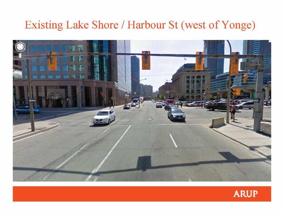
211
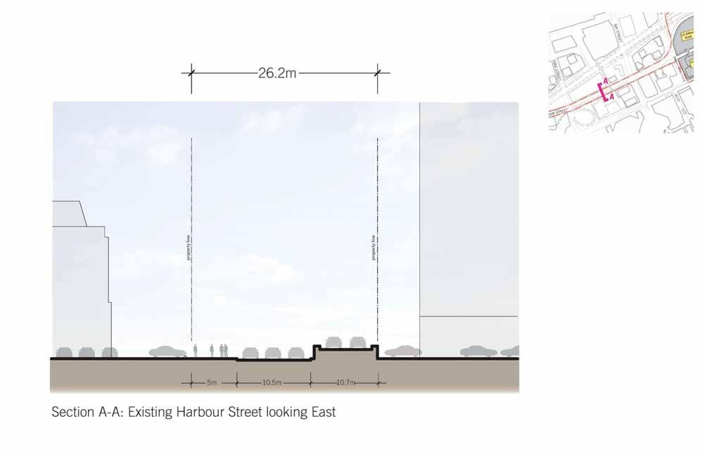
212
213
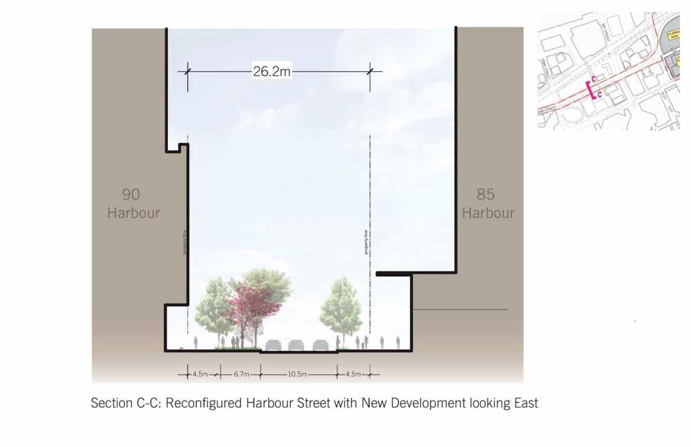
214
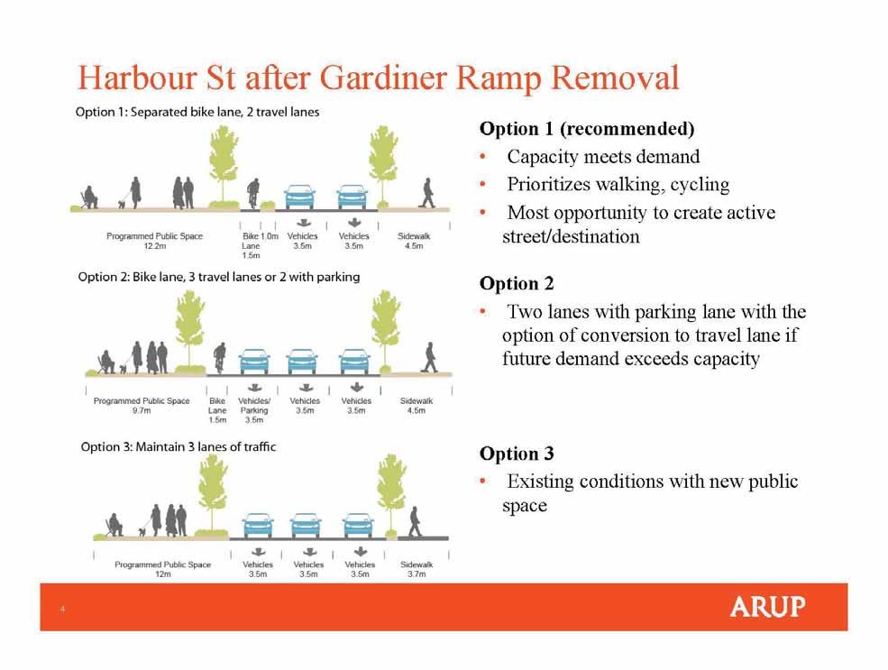
215
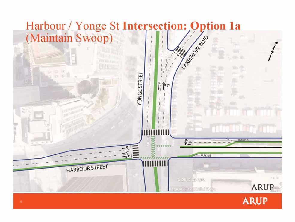
216
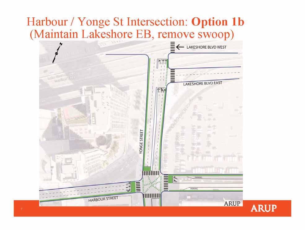
217
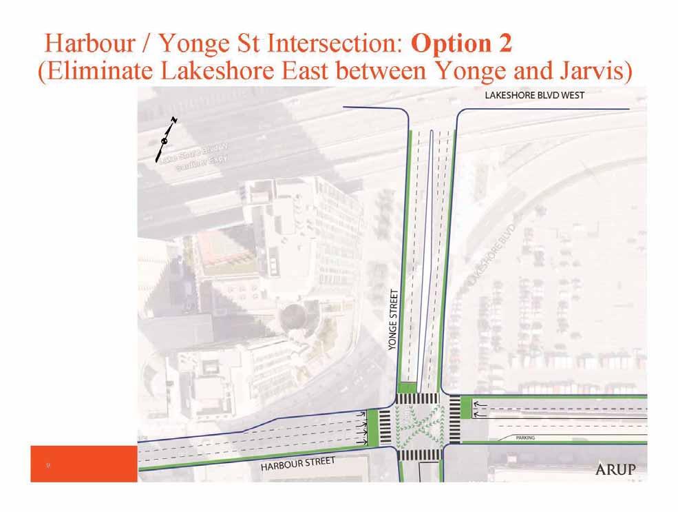
218


219 Section A-A Harbour Street Extension as a local Street A A

220 Section A-A Harbour Street Extension as Lakeshore Avenue A A
221 Harbour Street Study Option 1
222 Harbour Street Study Option 2
223 Harbour Street Study Option 3

224 Urban Design Guidelines + Transportation Master Plan September 9, 2013
225 PRECINCT PLAN PROCESS 1. Context + Study Area 2. What is a Precinct Plan? 3. Creating the Lower Yonge Precinct Plan 4. Going Forward Next steps


226 Lower Yonge Precinct - Context and Study Area Central Waterfront Secondary Plan City of Toronto Official Plan Land Use Map 18 Regeneration Areas designation
227 What is a Precinct Plan? --A Precinct Plan is a planning document that provides for the comprehensive and orderly development of areas in the waterfront. --When complete, the precinct plan and implementation tools will be adopted by City Council and will be used to inform the review of development applications. -- Policy tools include area specific Official Plan policies, Zoning Bylaws and Design Guidelines. Holding by-laws to secure further assessment of development impact and equitable cost sharing are used to phase and order development.
228 Why is a Precinct Plan Required? The Central Waterfront Plan is built on four core principles: 1. Removing Barriers/Making Connections 2. Building a Network of Spectacular Waterfront Parks and Public Spaces 3. Promoting a Clean and Green Environment 4. Creating Dynamic and Diverse New Communities A Precinct Plan helps ensure that these objectives are implemented in Regeneration Areas.

229 Waterfront Planning at the Precinct Level Lower Yonge Precinct
230 What is Included in a Precinct Plan? - A streets and blocks structure; - Standards for building height and massing; - Strategies to ensure a balance between residential and employment-based development; - Strategies for achieving affordable housing targets; - Location and phasing of local and regional parks, open spaces, public use areas, trails and connections;
231 What is included in a Precinct Plan? (cont d) - Location and phasing of schools, libraries, community/recreation centres, daycare, etc; - Servicing and infrastructure - Environmental performance standards; - Provisions for securing the retention of heritage buildings; - Urban design and public art provisions; - Provisions to secure necessary roads, transit, trails and bicycle paths; and - Financial mechanisms to ensure implementation.
232 Creating the Lower Yonge Precinct Plan: Process Website Resources Urban Design Guidelines Transportation Master Plan EA Stakeholder Advisory Committee Public Meetings Precinct Plan Phase 1 Precinct Plan Phase 2 Landowner Consultation Technical Advisory Committee
233 Creating the Lower Yonge Precinct Plan: Inputs and Assumptions To develop the models for the Urban Design Guidelines and Transportation Master Plan, the team used 8 assumptions/suggestions: 1. Net average density of 11x FSI - Reflects neighbouring sites (Pinnacle, Monde Parkside) - Provides a transition 2. 40% commercial and 60% residential land use balance -New waterfront communities require live and work balance for vibrancy and to reduce the number and length of commuter trips. -Reflects balance of uses west of Yonge between Queens Quay West, Simcoe Street, and Front Street. -Takes advantage of proximity to Union Station
234 Creating the Lower Yonge Precinct Plan: Inputs and Assumptions 3. Preferred locations for commercial uses - Proximity to Union Station (a mobility hub) - North side of Queens Quay East across from Redpath (existing active, industrial use on the waterfront) 4. Percentage of Parkland (public open space): 15% - Consistent with the alternative rate by-law for sites 1 to 5 hectares
235 Creating the Lower Yonge Precinct Plan: Inputs and Assumptions 5. Percentage of Landscaped Open Space (privately owned, publicly accessible): - City of Toronto Tall Building Guidelines includes setbacks, courtyards, plazas with a target of 25%. 6. Built form - Other waterfront precincts as precedents and context. - City of Toronto Tall Building Guidelines: - Master plans for larger sites, including sites that require new streets or parks, proposing multiple tall buildings, multiple phases of development, etc. - Where existing context is characterized by greater tower separation distances, more generous separation should be provided consistent with the context.
236 Creating the Lower Yonge Precinct Plan: Inputs and Assumptions 7. Street Network Opportunities - Eliminate the S curve that connects Harbour Street to Lake Shore Boulevard at Yonge Street - Extend Harbour Street through the precinct - Create stronger north/south connections, including bringing Cooper Street to Church Street across Lake Shore Boulevard/railway embankment
237 Creating the Lower Yonge Precinct Plan: Inputs and Assumptions 8. Heritage Preservation - Listed heritage properties to be preserved where feasible Lake Shore, LCBO Office & Warehouse, c listed Urban Design Guidelines and Transportation Master Plan EA must address this requirement while evaluating the need for a coherent network of streets, parks and open space. The exact location of road alignments will be refined through further detailed study.
238 Going Forward: Reviewing Development Applications -One development application has been received to date for 1-7 Yonge Street. - March application filed, followed by additional submissions - June preliminary report to Community Council - July application deemed complete -The review of the application is pending the outcome of the Precinct Plan work currently underway.

239 Development Application: 1 to 7 Yonge (Pinnacle) - Application to amend zoning by-law - 7 Towers - 88, 80, 80, 75, 70, 40, and 35 storeys - 1 office tower proposed - Addition to Toronto Star building - 1 hotel/residential - 4 residential towers with 8 storey base building with mixed commercial/retail x Floor Space Index
240 Going Forward: Next Steps - Public Meeting #2 September 19 -Framework of precinct plan and Transportation Master Plan EA to be considered by Council (Phase 1) target end of Further review of inputs, consultation and community meeting late fall Precinct Plan and implementation tools (Phase 2) - early 2014
241 URBAN DESIGN & TRANSPORTATION PRINCIPLES

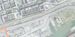
242 Study Area 19

243 Site Extents and Context 20
244 1. Ease of Movement Multiple, connected circulation paths make all forms of movement easier and more convenient. 2. Diversity of Uses A diversity of uses, conveniently located near each other, allows a work- live- play- shopenvironment without having to get into a car. 3. Well-Loved public Places People love and are drawn to places that offer high quality outdoor destinations that are safe and vibrant. 4. Pedestrian Comfort People enjoy / prefer places that are physically comfortable. 5. Good Urban Form People are inspired by and drawn to good urban form that graciously responds to context and human scale Principles 21

245 Goals: Getting to and from the precinct is easy locally and regionally. Active transportation is integral to precinct life. Connections to downtown and the waterfront are enhanced. 1. Ease of Movement Strategies: Connected Streets Increased Porosity Pedestrian Scaled Block Waterfront Access 22
246 Goals: Variety of services and amenities are within a convenient walking distance. Diversity of uses extend the day/night life and vibrancy of the precinct. Office uses are encouraged in proximity to transit. 2. Diversity of Uses Strategies: Diverse Uses Active Ground Floor + Small Shops 23
247 Goals: Public open space increases livability of high density precincts. People feel safe in active public places. Comfortable and attractive pedestrian and bike network is provided. 3. Well-Loved Public Places Strategies: Open Space Network Convenient Location Outdoor Recreation 24

248 Goals: Sunny places for people to sit, gather and enjoy outdoors. Wind protected outdoor places are active all year round. Streets and paths make a comfortable precinct-wide network 4. Pedestrian Comfort Strategies: Sunny Open Space Tall Buildings to the North Buffer Against Winter Winds 25
249 Goals: Diversity of building form brings interest within a distinctive City skyline. Heritage buildings and sites are respected. View corridors open views to the waterfront and the City. Views are maximized while negative impact on public realm is minimized. 5. Good Urban Form Strategies: Variety of Building Types View Corridors Solar Access 26
250 What We Heard at the First Public Meeting, CREATE AN APPEALING NEIGHBORHOOD through communityloved public open spaces and safe, comfortable streets. ADDRESS IMPACTS OF INCREASED DENSITY, such as vehicle congestion issues and lack of green open space. Create an urban form that RESPECTS THE SURROUNDING CHARACTER OF THE WATERFRONT and does not negatively impact views from the public realm. 27
251 Create an appealing neighborhood through community-loved public open spaces and safe, comfortable streets Introduce a significant new public open space as the signature of the neighborhood Reduce building massing immediately adjacent to public ways to provide greater pedestrian comfort. o Set podium building heights to allow greater access to direct sun. o Require stepbacks to reduce building massing along this special waterfront street. o Provide strategic setbacks for a generous pedestrian realm on streets. Response to What We Heard 28
252 Address impacts of increased density, such as vehicle congestion issues and lack of green open space Careful consideration of taller buildings will ensure access to light, air and physical/visual access toward Queens Quay and the waterfront. o Locate towers to maintain a light and air along the skyline and avoid blocking views through the precinct from public spaces. o Shape low-rise podiums to prevent overshadowing the other side of the sidewalk. o Locate tallest towers north of Harbour Street to minimize overshadowing within the Lower Yonge Precinct. Response to What We Heard 29
253 Create an urban form that respects the surrounding character of the waterfront and does not negatively impact views from the public realm A respectful relationship between new buildings and the existing context will enhance the character of the waterfront. o Establish a height transition between Downtown building heights to the west and East Bayfront heights to the east. o Locate taller towers along major north-south street as visual gateways to the Lower Yonge Precinct and the waterfront. o Step building heights down towards the waterfront in order to maximize views to the water and increase access to direct sun. Response to What We Heard 30
254 URBAN DESIGN GUIDELINES: 1. Streets + Open Space 2. Setbacks + Ground Floor Animation 3. Base Buildings + Stepbacks 4. Tower Heights + Floor Plates 5. Urban Form and View Studies
255 1. Streets + Open Space 32
256 Existing Site Existing Site 33
257 Existing Site Existing Site 34
258 Existing Site Existing Site 35
259 Existing Site Existing Site 36
260 New Streets & Blocks New Streets & Blocks 37
261 Five new intersections within the precinct meet LEED ND standards. LEED ND 5.4 Intersections / 10 Hectare Lower Yonge Site 5.6 Intersections / 10 Hectare Streets: Internal connectivity 38
262 Five new intersections within the precinct meet LEED ND standards. LEED ND 5.4 Intersections / 10 Hectare Lower Yonge Site 5.6 Intersections / 10 Hectare Streets: Internal connectivity 39
263 Five new intersections within the precinct meet LEED ND standards. LEED ND 5.4 Intersections / 10 Hectare Lower Yonge Site 5.6 Intersections / 10 Hectare Streets: Internal connectivity 40
264 Five new intersections within the precinct meet LEED ND standards. LEED ND 5.4 Intersections / 10 Hectare Lower Yonge Site 5.6 Intersections / 10 Hectare Streets: Internal connectivity 41


265 Open spaces along Toronto Waterfront are typically located 200 to 250 meters apart, approximately a 2.5 to 3 minute walk. Open Space: Pattern of waterfront open space 42


266 A consolidated, new public open space at the center of the Lower Yonge Precinct will continue this pattern. Open Space: Pattern of waterfront open space 43

267 A consolidated, new public open space will equal 15% of the total Lower Yonge site area and can be configured in a variety of ways. 15% Consolidated Open Space: 15 % of total precinct area 44
268 A consolidated, new public open space will equal 15% of the total Lower Yonge site area and can be configured in a variety of ways. 15% Consolidated Open Space: 15 % of total precinct area 45


269 A consolidated, new public open space will equal 15% of the total Lower Yonge site area and can be configured in a variety of ways. In addition, at-grade privately-owned publiclyaccessible open space will be required. 15% Consolidated Open Space: 15 % of total precinct area 46


270 HARBOUR STREET Harbour Street 47
271 HARBOUR STREET: West of Yonge Street Harbour Street: West of Yonge Street 48


272 The reconfigured Harbour Street, between Lower Simcoe Street and Bay Street has 4 travel lanes: 1 west bound lane 3 east bound lane 27M Harbour Street: West of Yonge Street (York to Bay) 49


273 The reconfigured Harbour Street, west of Yonge Street, will align with the new extension of Harbour Street, east of Yonge Street. 27M Harbour Street: West of Yonge Street (Bay to Yonge) 50
274 HARBOUR STREET East of Yonge Street Harbour Street: East of Yonge Street 51

275 There are two vehicle travel lanes in both directions between Yonge Street and Freeland Street. The outside lanes are designated as Sharrows. Harbour Street: East of Yonge Street (Yonge to Freeland) 52


276 The ratio between street width to streetwall height will provide a comfortably scaled public realm. Harbour Street: East of Yonge Street (Yonge to Freeland) 53
277 Sidewalks will have a consistent Furnishing / Planting Zone and Throughway Zone. The north side of the street will allow for a Frontage Zone. Harbour Street: East of Yonge Street (Freeland to Jarvis) 54


278 At the heart of the precinct Harbour Street will form the north edge of the new public open space. Harbour Street: East of Yonge (Between Freeland & Cooper) 55


279 Harbour Street at the heart of the precinct is a Neighborhood Street with 3 travel lanes: 1 west bound lane 1 east bound lane 1 turning lane Harbour Street: East of Yonge Street 56
280 Streets Guidelines: Provide a minimum 5 intersections within site area, with signalized pedestrian crossings. Harbour Street will have a consistent 27 meter public right-ofway Freeland Street, Cooper Street and New Street will have a consistent 20 meter public right-of-way. Open Space Guidelines: Provide a consolidated public open space equal to 15% of total site area, in a central location along Queens Quay. Provide additional publicly accessible, privately owned open space. Guidelines for Streets + Open Space 57
281 2. Setbacks + Ground Floor Animation 58


282 Building setbacks along both sides of North-South Streets will provide a comfortable oneto-one ratio between street width and building height. Streets: North-South Streets 59


283 Building setbacks along both sides of North-South Streets will provide a comfortable oneto-one ratio between street width and building height. Streets: North-South Streets 60


284 Ground floor active uses will be located to activate the public realm. Ground Floor Animation: Active Frontages 61


285 Ground floor active uses will include taller ceiling heights, greater transparency and outdoor seating or other publicly oriented activities. Active Uses Ground Floor Animation: Active Uses 62


286 Ground floor active uses will extend into the sidewalk enlivening the public realm. Ground Floor Animation: Active Frontages 63


287 Ground floor spaces will invite the public into the ground floors of adjacent buildings. Ground Floor Animation: Public Realm Public Realm 64


288 Ground floor spaces will invite the public into the ground floors of adjacent buildings. Ground Floor Animation: Public Realm 65
289 Setback Guidelines: Provide a: 17 meter setback along Yonge Street as per existing guidelines 3 meter setback along Freeland Street, Cooper Street, New Street. Ground Floor Animation Guidelines: Provide active uses that extend into, and engage the public realm along the ground floor of Harbour Street, Queens Quay, around the park and Yonge Street and Jarvis Street. To allow for a wide diversity and fine grain of active uses a percentage leased spaces on the ground floor will be smaller than 50 square meters. Guidelines for Setbacks + Stepbacks 66
290 3. Base Buildings + Stepbacks 67


291 Existing sun conditions in the precinct offer great potential to plan for sunny spaces both public and private. 9:30 am 12:00 pm 2:30 pm Open Space: Existing Sun Conditions, Spring and Fall 68


292 Solar access envelopes will ensure base buildings maximize direct sun on open spaces and north/south streets Open Space: Access to Spring/Fall Sun 69


293 Solar access envelopes shown here, and base building heights will work together to maximize sun on open spaces and north/south streets leading towards Queens Quay, the waterfront street. Base Building: Access to Spring/Fall Sun 70


294 Building stepbacks at upper levels will reduce the perception of building massing from the public realm and allow greater access to sunlight along Queens Quay, Harbour Street and Lake Shore Blvd. Stepbacks: Queen s Quay and Harbour Street 71
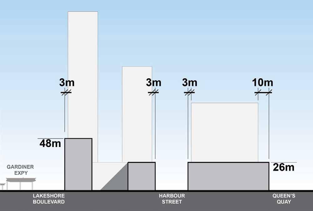
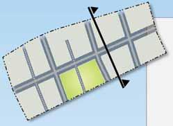
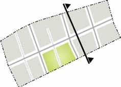
295 Stepbacks: Streets that are parallel to the waterfront 72


296 Building stepbacks at upper levels along streets that lead to Queens Quay will open views to the waterfront. Stepbacks: Streets that lead to the Waterfront 73
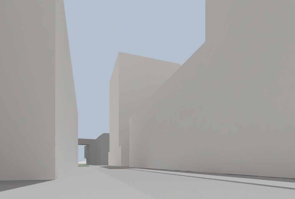
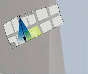
297 Stepbacks: Streets that lead to the Waterfront 74 26
298 Stepbacks: Streets that lead to the Waterfront 75 26


299 Building stepbacks along the Lakeshore Boulevard frontage of the heritage building will help preserve its existing character. Stepbacks: Streets that lead to the Waterfront 76


300 Podium heights will be allowed up to 26 meters across the entire precinct and up to 48 meters along Lake Shore Blvd and the north block along Yonge Street. Base Buildings: Maximum height zones 26 m 48 m 77
Director, Community Planning, Toronto and East York District
 Lower Yonge Precinct Plan Update STAFF REPORT ACTION REQUIRED Date: October 16, 2012 To: From: Wards: Reference Number: Toronto and East York Community Council Director, Community Planning, Toronto and
Public Meeting #3 May 9, 2009 MVVA Team
 Public Meeting #3 May 9, 2009 MVVA Team Welcome to the third Public Meeting for the Lower Don Lands Municipal Class Environmental Assessment (EA) Infrastructure Master Plan and Keating Channel Precinct
Purpose of Open House #3
 Public Meeting #3 May 9, 2009 MVVA Team Purpose of Open House #3 The main purpose of this Open House is to present and seek input on the: Evaluation of transportation and infrastructure design alternatives
Chairman and Members of the Planning and Development Committee. Thomas S. Mokrzycki, Commissioner of Planning and Building
 LA.09.TOR (Toronto) DATE: TO: FROM: SUBJECT: Chairman and Members of the Planning and Development Committee Thomas S. Mokrzycki, Commissioner of Planning and Building Central Waterfront Secondary Plan
Urban Design Report: Principles and Recommendations AUGUST 2014
 Urban Design Report: Principles and Recommendations AUGUST 2014 PREPARED FOR WATERFRONT TORONTO 20 BAY STREET, SUITE 1310 TORONTO, ONTARIO M5J 2N8 +1.416.214.1344 TOC CITY OF TORONTO 100 QUEEN STREET WEST
St. Clair Avenue West Area Transportation Master Plan
 1 (Between Keele Street and Old Weston Road) Public Information Centre 1 December 2, 2015 2 Welcome Welcome to the first Public Information Centre for the St. Clair Avenue West Area. The panels will present
38 Queen s University Campus Master Plan Part 1
 38 Queen s University Campus Master Plan Part 1 46 The Campus at the City Scale Chapter 4 The Campus at the City Scale 39 Queen s is an urban University centrally located in Kingston. Decisions made by
South of Eastern Strategic Direction Status Update
 STAFF REPORT ACTION REQUIRED South of Eastern Strategic Direction Status Update Date: July 10, 2014 To: From: Planning and Growth Management Committee Chief Planner and Executive Director, City Planning
1.0 Purpose of a Secondary Plan for the Masonville Transit Village
 Report to Planning and Environment Committee To: Chair and Members Planning & Environment Committee From: John M. Fleming Managing Director, Planning and City Planner Subject: Masonville Transit Village
City of Toronto. Emery Village Transportation Master Plan
 City of Toronto Emery Village Transportation Master Plan May 2009 Emery Village Transportation Master Plan Toronto, ON May 2009 Consulting Inc. 100 York Blvd., Suite 300 Richmond Hill, ON L4B 1J8 Tel:
SCARBOROUGH SUBWAY EXTENSION. Scarborough Subway Extension. Final Terms of Reference
 Scarborough Subway Extension Final Terms of Reference 1 1.0 Introduction and Background 1.1 Introduction Toronto City Council recently confirmed support for an extension of the Bloor-Danforth Subway from
FANSHAWE PARK ROAD/RICHMOND STREET INTERSECTION IMPROVEMENTS. PUBLIC INFORMATION CENTRE 2 June 16, 2016
 FANSHAWE PARK ROAD/RICHMOND STREET INTERSECTION IMPROVEMENTS Municipal Class Environmental Assessment PUBLIC INFORMATION CENTRE 2 June 16, 2016 ACCESSIBILITY Under the Accessibility Standards 2015 for
Welcome. Walk Around. Talk to Us. Write Down Your Comments
 Welcome This is an information meeting introducing the applications for proposed redevelopment of the Yorkdale Shopping Centre site at 3401 Dufferin Street and 1 Yorkdale Road over the next 20+ years,
THAT the attached Terms of Reference for the Thornhill Centre Street Study be approved.
 COMMITTEE OF THE WHOLE AUGUST 18, 2003 THORNHILL CENTRE STREET STUDY PLANNING FILE: 15.92 Recommendation The Commissioner of Planning recommends: THAT the attached Terms of Reference for the Thornhill
Don Mills Crossing Study and Celestica Lands Development Application Community Meeting, Open House, and Breakout Discussions
 Consultation Summary Don Mills Crossing Study and Celestica Lands Development Application Community Meeting, Open House, and Breakout Discussions This report is not intended to provide a verbatim transcript
Welcome. Community Consultation Meeting November 28, Review and discuss the Bathurst Quay Neighbourhood Plan Framework
 Welcome Community Consultation Meeting November 28, 2016 Why Are We Here Today? Review and discuss the Bathurst Quay Neighbourhood Plan Framework Review and discuss an Action Plan for Implementation Next
Urban Design Manual PLANNING AROUND RAPID TRANSIT STATIONS (PARTS) Introduction. Station Study Areas
 Introduction. Station Study Areas") 111111 PLANNING AROUND RAPID TRANSIT STATIONS (PARTS) Introduction The ION rapid transit system will link Waterloo, Kitchener and Cambridge through a central transit corridor (CTC). There are a number
111111 PLANNING AROUND RAPID TRANSIT STATIONS (PARTS) Introduction The ION rapid transit system will link Waterloo, Kitchener and Cambridge through a central transit corridor (CTC). There are a number
SUBJECT: Waterfront Hotel Planning Study Update TO: Planning and Development Committee FROM: Department of City Building. Recommendation: Purpose:
 Page 1 of Report PB-23-18 SUBJECT: Waterfront Hotel Planning Study Update TO: Planning and Development Committee FROM: Department of City Building Report Number: PB-23-18 Wards Affected: 2 File Numbers:
Coordinated Transit Planning in Toronto SmartTrack GO RER Scarborough Relief Line Waterfront Transit
 Coordinated Transit Planning in Toronto SmartTrack GO RER Scarborough Relief Line Waterfront Transit Public Information Centres February 2016 Transportation Planning Section City Planning Division Toronto
Director, Community Planning, Toronto and East York District
 STAFF REPORT ACTION REQUIRED 55 to 95 Lake Shore Boulevard East, 33 53 Freeland Street and 2 and 15 Cooper Street - Official Plan Amendment and Zoning Amendment Application - Request for Direction Report
GARDINER EXPRESSWAY AND LAKE SHORE BOULEVARD EAST RECONFIGURATION ENVIRONMENTAL ASSESSMENT Planning, Urban Design, Public Realm and Socio- Economic
 GARDINER EXPRESSWAY AND LAKE SHORE BOULEVARD EAST RECONFIGURATION ENVIRONMENTAL ASSESSMENT Socio- Economic Background Conditions Report - 2014 Socio-Economic Background Conditions Report 2014 TABLE OF
John M. Fleming Managing Director, Planning and City Planner. Old East Village Dundas Street Corridor Secondary Plan Draft Terms of Reference
 Report to Planning and Environment Committee To: From: Subject: Chair and Members Planning & Environment Committee John M. Fleming Managing Director, Planning and City Planner Old East Village Dundas Street
ELMVALE ACRES SHOPPING CENTRE MASTER PLAN
 ELMVALE ACRES SHOPPING CENTRE MASTER PLAN Contents 1.0 INTRODUCTION... 2 2.0 LOCATION... 2 3.0 EXISTING CONTEXT... 2 4.0 VISION & GUIDING PRINCIPLES... 2 5.0 LAND USE AND BUILT FORM... 4 5.1 St. Laurent
St. Lawrence Neighbourhood Focused Area - Official Plan Amendment Status Report
 STAFF REPORT ACTION REQUIRED St. Lawrence Neighbourhood Focused Area - Official Plan Amendment Status Report Date: May 21, 2015 To: From: Wards: Reference Number: Toronto and East York Community Council
McCowan Precinct Plan Study Background & Deliverables
 1 DRAFT & WITHOUT PREJUDICE McCowan Precinct Plan Study Background & Deliverables In September, 2011, City Planning (Scarborough District) began a study of an area within the Scarborough Centre, identified
1 7 Yonge Street - Official Plan Amendment & Zoning Amendment Applications - Request for Direction Report
 STAFF REPORT ACTION REQUIRED 1 7 Yonge Street - Official Plan Amendment & Zoning Amendment Applications - Request for Direction Report Date: May 16, 2016 To: From: Wards: Reference Number: Toronto and
THE GARDEN CITY PLAN. City of St. Catharines Official Plan. City of St. Catharines
 THE GARDEN CITY PLAN City of St. Catharines Official Plan City of St. Catharines August 2010 APPROVAL INFORMATION This Official Plan of the City of St. Catharines Planning Area, known as the Garden City
DOWNTOWN PARKS & PUBLIC REALM PLAN
 DOWNTOWN PARKS & PUBLIC REALM PLAN CHALLENGES The Parks and Public Realm Strategy addresses challenges associated with a growing Downtown, including: GOALS 3.3 New buildings will fit within their existing
Town of Oakville Streetscape Strategy
 Town of Oakville Streetscape Strategy Endorsed by PDC on February 10, 2014 (PD-011-14) Town of Oakville Streetscape Strategy [endorsed by PDC February 10, 2014] 0 Town of Oakville Streetscape Strategy
Redevelopment of Ajax Plaza Area Public Open House Meeting February 19, 2015 Questions and Answers
 Redevelopment of Ajax Plaza Area Public Open House Meeting February 19, 2015 Questions and Answers Redevelopment of Ajax Plaza Area Why is the redevelopment of the Ajax Plaza important to the revitalization
5 TOWN OF MARKHAM OFFICIAL PLAN AMENDMENT NO. 144 MILLIKEN MAIN STREET SECONDARY PLAN
 5 TOWN OF MARKHAM OFFICIAL PLAN AMENDMENT NO. 144 MILLIKEN MAIN STREET SECONDARY PLAN The Planning and Economic Development Committee recommends the following: 1. The communication from Brendan O Callaghan,
30 Bay Street and 50 Harbour Street - Zoning Amendment Application - Preliminary Report
 STAFF REPORT ACTION REQUIRED 30 Bay Street and 50 Harbour Street - Zoning Amendment Application - Preliminary Report Date: May 18, 2018 To: From: Wards: Reference Number: Toronto and East York Community
13 THORNHILL YONGE STREET STUDY IMPLEMENTATION CITY OF VAUGHAN OPA 669 AND TOWN OF MARKHAM OPA 154
 13 THORNHILL YONGE STREET STUDY IMPLEMENTATION CITY OF VAUGHAN OPA 669 AND TOWN OF MARKHAM OPA 154 The Planning and Economic Development Committee recommends the adoption of the recommendations contained
1.3 TRANSIT VISION 2040 FROM VISION TO ACTION THEME 1: PUTTING TRANSIT AT THE CENTRE OF COMMUNITIES. Fully integrate transit with community planning
 TRANSIT VISION 2040 FROM VISION TO ACTION TRANSIT VISION 2040 defines a future in which public transit maximizes its contribution to quality of life with benefits that support a vibrant and equitable society,
Public input has been an important part of the plan development process.
 Lakewood s Comprehensive Plan recognizes that transportation helps shape the community, and that the way the community provides for the safe and efficient movement of people affects the character of the
PART 1. Background to the Study. Avenue Study. The Danforth
 The Danforth 1.1/ Study Purpose & Key Municipal Goals 1.2/ The Local Advisory Committee 1.3/ The Project Team 1.4/ Study Process/Summary of Method 1.5/ Summary of Consultation 1.1 Study Purpose and Key
CITY OF CHARLOTTESVILLE, VIRGINIA CITY COUNCIL AGENDA
 CITY OF CHARLOTTESVILLE, VIRGINIA CITY COUNCIL AGENDA Agenda Date: December 16, 2013 Action Required: Adoption of Resolution Presenter: Staff Contacts: Title: James E. Tolbert, AICP, Director of NDS James
CITY OF VAUGHAN EXTRACT FROM COUNCIL MEETING MINUTES OF NOVEMBER 15, 2016
 Item 11, Report No. 38, of the Committee of the Whole, which was adopted without amendment by the Council of the City of Vaughan on November 15, 2016. Regional Councillor Di Biase declared an interest
9 CITY OF VAUGHAN OFFICIAL PLAN AMENDMENT NO BOCA EAST INVESTMENTS LIMITED
 9 CITY OF VAUGHAN OFFICIAL PLAN AMENDMENT NO. 631 - BOCA EAST INVESTMENTS LIMITED The Planning and Economic Development Committee recommends the adoption of the recommendations contained in the following
Public Open House. Overview of the Downtown Plan Official Plan Amendment April 23, 2018
 Public Open House Overview of the Downtown Plan Official Plan Amendment April 23, 2018 1 A 25-Year Plan for Downtown To ensure growth contributes positively to Toronto s Downtown as a great place to live,
Midtown Greenway Land Use and Development Plan Executive Summary
 Midtown Greenway Land Use and Development Plan Executive Summary Introduction The Midtown Greenway Land Use and Development Plan sets policy direction for land use and development in the Midtown Greenway
Portage Parkway Environmental Assessment Public Information Centre No. 1
 City of Vaughan Portage Parkway Environmental Assessment Public Information Centre No. 1 November 25, 2015 Welcome to the Public Information Centre This first Public Information Centre (PIC) introduces
Streets for People, Place-Making and Prosperity. #TOcompletestreets
 COMPLETE STREETS FOR TORONTO Streets for People, Place-Making and Prosperity COMPLETE STREETS: A NEW APPROACH A Complete Streets design approach considers the needs of all users people who walk, bicycle,
CITY OF VAUGHAN EXTRACT FROM COUNCIL MEETING MINUTES OF JUNE 7, 2016
 Item 5, Report No. 26, of the Committee of the Whole (Working Session), which was adopted without amendment by the Council of the City of Vaughan on June 7, 2016. 5 MUNICIPAL CLASS ENVIRONMENTAL ASSESSMENT
Former Rockcliffe Airbase Community Design Plan Guiding Design Vision and Principles December 4, 2013
 APPENDIX 5 - Guiding Design Vision and Principles Former Rockcliffe Airbase Community Design Plan Guiding Design Vision and Principles December 4, 2013 Vision Statement The redevelopment of the former
Queens Quay East & Lake Shore Boulevard East & 26 Richardson Street Public Art Plan
 STAFF REPORT ACTION REQUIRED 130-132 Queens Quay East & 143-177 Lake Shore Boulevard East & 26 Richardson Street Public Art Plan Date: April 20, 2016 To: From: Toronto East York Community Council Director,
Canadian Consulting Engineering Awards 2016 Queens Quay West Revitalization. Category B: Transportation
 Canadian Consulting Engineering Awards 2016 Queens Quay West Revitalization Category B: Transportation April 2016 Arup Contents Online Submission Confirmation Receipt Entry Consent Form Project Information...1
Welcome to the Oakridge Centre Open House
 Welcome to the Oakridge Centre Open House Why is the City hosting this event? This open house is to inform you of a rezoning application submitted to the City of Vancouver to amend the existing CD-1 (Comprehensive
APPENDIX L3. Table of Contents. SWP EA Information Sheets
 E N V I R O N M E N T A L A S S E S S M E N T APPENDIX L3 SWP EA Information Sheets Table of Contents EA Info Sheet 1... L3-1 EA Info Sheet 2... L3-3 EA Info Sheet 3... L3-5 EA Info Sheet 4... L3-7 SCARBOROUGH
URBAN DESIGN BRIEF URBAN DESIGN BRIEF 721 FRANKLIN BLVD, CAMBRIDGE August 2018
 URBAN DESIGN BRIEF URBAN DESIGN BRIEF 721 FRANKLIN BLVD, CAMBRIDGE August 2018 DESIGN BRIEF CONTENTS PART A 1.0 INTRODUCTION 2.0 DESCRIPTION & ANALYSIS OF SITE CONTEXT 3.0 DESIGN CONSTRAINTS AND OPPORTUNITIES
URBAN DESIGN BRIEF. 2136&2148 Trafalgar Road. Town of Oakville
 URBAN DESIGN BRIEF 2136&2148 Trafalgar Road Town of Oakville Prepared By: METROPOLITAN CONSULTING INC For 2500674 Ontario Inc November 2016 TABLE OF CONTENTS Page No. 1.0 Introduction/Description of Subject
PLAN ELEMENTS WORKSHOP. April 5, 2016
 PLAN ELEMENTS WORKSHOP April 5, 2016 needs more housing. But there is no one-size fits-all solution. Every neighborhood has its own character. In some places, density is not only appropriate it is badly
CITY COUNCIL AGENDA REPORT
 CITY COUNCIL AGENDA REPORT Subject: COUNCIL MOTION LRT ALIGNMENT REMOVAL FROM THE TRANSPORTATION MASTER PLAN On February 10, 2016 Councillor Hughes provided notice in accordance with Section 23 of Procedure
CONSULTING SERVICES FOR THE WHITEBELT VISIONING EXERCISE ADDENDUM TO THE GTA WEST LAND USE STUDY WORK PROGRAM
 CONSULTING SERVICES FOR THE WHITEBELT VISIONING EXERCISE ADDENDUM TO THE GTA WEST LAND USE STUDY 1. Introduction WORK PROGRAM The Town of Caledon is a large, local municipality located in the Greater Toronto
Mark-up of the effect of the proposed Bronte Village Growth Area OPA No.18 on the text of section 24, Bronte Village, of the Livable Oakville Plan
 Mark-up of the effect of the proposed Bronte Village Growth Area OPA No.18 on the text of section 24, Bronte Village, of the Livable Oakville Plan Notes: This document is provided for information purposes
Toronto Complete Streets Guidelines
 c. DTAH 58 60 3.1 70 3.2 Performance Measurement 71 3.3 Exceptions Chapter 3 describes the five general steps in the street design process. Not all projects follow these steps, as the number of steps and
planningalliance City of Toronto Lawrence Allen Revitalization Project Transportation Master Plan
 planningalliance City of Toronto Lawrence Allen Revitalization Project Transportation Master Plan September 2011 This report takes into account the particular instructions and requirements of our client.
The West Vaughan Employment Area Secondary Plan Policies
 Part 2: The West Vaughan Employment Area Secondary Plan Policies 2.1 General Policies It is the policy of Council: 2.1.1. That the West Vaughan Employment Area (the WVEA), identified on Schedule 1, will
Report to: Development Services Committee Report Date: September 11, 2017
 ~RKHAM Report to: Development Services Committee Report Date: September 11, 2017 SUBJECT: PREPARED BY: Conceptual Master Plan for the Future Urban Area - Community Structure Plan and Key Policy Direction
planning toronto s downtown Parks and Public Realm Plan Request for Proposals Information Meeting Andrew Farncombe, Project Manager August 19, 2015
 planning toronto s downtown Parks and Public Realm Plan Request for Proposals Information Meeting Andrew Farncombe, Project Manager August 19, 2015 BATHURST ST Keeping Downtown a great place to live, work,
PORT WHITBY COMMUNITY
 PORT WHITBY COMMUNITY SECONDARY PLAN UPDATE COMMUNITY IMPROVEMENT PLAN URBAN DESIGN GUIDELINES September 2015 DRAFT PROPOSED AMENDMENT NUMBER # to the Whitby Official Plan PURPOSE: The intent of this Amendment
Edward R. Sajecki Commissioner of Planning and Building
 Corporate Report Clerk s Files Originator s Files CD.03.POR DATE: TO: FROM: SUBJECT: Chair and Members of Planning and Development Committee Meeting Date: February 27, 2012 Edward R. Sajecki Commissioner
Public Information Centre #1
 and Highway 401 Interchange Improvements WELCOME Public Information Centre #1 Veterans Memorial Parkway Extension and Highway 401 Interchange Improvements Study May 23, 2012 4 p.m. to 7 p.m. Brief Overview
Public Works and Infrastructure Committee
 STAFF REPORT ACTION REQUIRED Progress Report on Design Concepts for the Hybrid EA Preferred Alternative Gardiner Expressway and Lake Shore Boulevard East Reconfiguration Environmental Assessment (EA) and
Land Use Amendment in Southwood (Ward 11) at and Elbow Drive SW, LOC
 at and Elbow Drive SW, LOC") 2018 November 15 Page 1 of 10 EXECUTIVE SUMMARY This land use amendment application was submitted by Rick Balbi Architect on 2017 August 31 on behalf of Sable Developments Ltd, and with authorization from
2018 November 15 Page 1 of 10 EXECUTIVE SUMMARY This land use amendment application was submitted by Rick Balbi Architect on 2017 August 31 on behalf of Sable Developments Ltd, and with authorization from
WELCOME TO OPEN HOUSE TWO November 28, 2018
 Langstaff Road Weston Road to Highway 7 Class Environmental Assessment Study WELCOME TO OPEN HOUSE TWO November 28, 2018 Please sign in and join our mailing list Study Overview York Region is conducting
350, 370, and 390 Queens Quay West Official Plan Amendment and Zoning Amendment Applications - Preliminary Report
 STAFF REPORT ACTION REQUIRED 350, 370, and 390 Queens Quay West Official Plan Amendment and Zoning Amendment Applications - Preliminary Report Date: April 22, 2016 To: From: Wards: Reference Number: Toronto
Relief Line Project Assessment
 Relief Line Project Assessment Public Information Centre April 5, 2017 Tonight s Meeting PURPOSE To review the preferred alignment for the Local Segment. AGENDA 6:30 Open House 7:00 Presentation / Discussion
New-Cast Mixed-use Development Proposal King Street West, Newcastle, Ontario
 URBAN DESIGN BRIEF New-Cast Mixed-use Development Proposal King Street West, Newcastle, Ontario TABLE OF CONTENTS: 1.0 Executive Summary 2.0 Creating Vibrant and Sustainable Urban Places: Excerpts from
TORONTO COMPLETE STREETS GUIDELINES
 TORONTO COMPLETE STREETS GUIDELINES Presentation by Fiona Chapman, Manager, Pedestrian Projects Public Realm Section, Transportation Services, City of Toronto June 2017 PURPOSE OF THE PROJECT To develop
Town of Cobourg Heritage Master Plan. Statutory Public Meeting
 Town of Cobourg Heritage Master Plan Statutory Public Meeting April 25 th 2016 Presentation Overview 1. Introduction 2. Project background and schedule overview 3. Review of strategic direction content
Rail Deck Park - City-initiated Official Plan Amendment Final Report
 STAFF REPORT ACTION REQUIRED Rail Deck Park - City-initiated Official Plan Amendment Final Report Date: October 30, 2017 To: From: Wards: Reference Number: Toronto and East York Community Council Acting
FOUR MILE RUN VALLEY WORKING GROUP AND CHARGE
 FOUR MILE RUN VALLEY WORKING GROUP AND CHARGE Adopted April 16, 2016 Amended July 19, 2016 Overview of Integrated Effort The overall goal of the Four Mile Run Valley (4MRV) initiative is to develop a comprehensive
ARLINGTON COUNTY, VIRGINIA
 ARLINGTON COUNTY, VIRGINIA County Board Agenda Item Meeting October 15, 2005 DATE: September 28, 2005 SUBJECT: Request to Advertise the adoption of the 2005 Clarendon Sector Plan C. M. RECOMMENDATION:
~!VAUGHAN NOV Z November 21, Mr. Denis Kelly, Regional Clerk The Regional Municipality of York Yonge Street Newmarket, ON L3Y 6Z1
 ~!VAUGHAN NOV Z 5 2016 November 21, 2016 Mr. Denis Kelly, Regional Clerk The Regional Municipality of York 17250 Yonge Street Newmarket, ON L3Y 6Z1 Dear Mr. Kelly: RE: NEW KIRBY GO STATION IN BLOCK 27
Commissioners Road West Realignment Environmental Assessment
 City of London Commissioners Road West Realignment Environmental Assessment Public Information Centre No. 1 March 30, 2017 Welcome to the Public Information Centre This first Public Information Centre
Town Center (part of the Comprehensive Plan)
") Town Center (part of the Comprehensive Plan) Mercer Island Town Center Looking North (2014) In 1994, a year-long process culminated in a set of design guidelines and code requirements for the Town Center
Town Center (part of the Comprehensive Plan) Mercer Island Town Center Looking North (2014) In 1994, a year-long process culminated in a set of design guidelines and code requirements for the Town Center
CITY CLERK. Parkland Acquisition Strategic Directions Report (All Wards)
") CITY CLERK Clause embodied in Report No. 10 of the, as adopted by the Council of the City of Toronto at its meeting held on November 6, 7 and 8, 2001. 10 Parkland Acquisition Strategic Directions Report
CITY CLERK Clause embodied in Report No. 10 of the, as adopted by the Council of the City of Toronto at its meeting held on November 6, 7 and 8, 2001. 10 Parkland Acquisition Strategic Directions Report
Second Line West Pedestrian/Cyclist Crossing of Highway 401 Class EA. Second Line West Pedestrian/Cyclist Crossing of Highway 401 Class EA
 1 1 Purpose of Public Information Centre #2 To provide interested and/or potentially affected stakeholders with an opportunity to participate in the planning and decision-making process for this Municipal
Long Branch Neighbourhood Character Guidelines Final Report
 STAFF REPORT ACTION REQUIRED Long Branch Neighbourhood Character Guidelines Final Report Date: October 26, 2017 To: From: Wards: Reference Number: Etobicoke York Community Council Director, Community Planning,
Derry Green Corporate Business Park
 Town of Milton Derry Green Corporate Business Park Urban Design Guidelines BMI/Pace - June 2010 Draft 3 Prepared by: Brook McIlroy Planning + Urban Design / Pace Architects Suite 300-51 Camden Street Toronto,
Clairtrell Area Context Plan
 Clairtrell Area Context Plan March 2005 Urban Development Services City Planning Contents 1. Introduction... 4 2. Development Structure... 6 2.1 Streets... 7 2.1.1 Sheppard Avenue and Bayview Avenue...
DRAFT Subject to Modifications
 TREASURE COAST REGIONAL PLANNING COUNCIL M E M O R A N D U M To: Council Members AGENDA ITEM 8 From: Date: Subject: Staff May 19, 2017 Council Meeting Florida Department of Transportation Complete Streets
hermitage town center
 hermitage town center A Community Vision prepared by Strada for The City of Hermitage and The Mercer County Regional Planning Commission January 2007 table of contents introduction 3 design principles
4.1.3 LAND USE CATEGORIES
 4.1.3 LAND USE CATEGORIES a. City Center District The City Center District incorporates the existing character and mix of uses in downtown Belmont to encourage redevelopment and new development in keeping
Macintosh HD:CURRENT WORK-(JRW):4026 Northumberland Trent River Crossings:4026_Mem- Pannu_Report(jm)Oct2510.docx
:4026 Northumberland Trent River Crossings:4026_Mem- Pannu_Report(jm)Oct2510.docx") MEMORANDUM To: Mobushar Pannu, County of Northumberland From: Nick McDonald Date: October 27, 2010 Re: First Draft of Report (Trent River Crossing) Our File No: 4026 Attached to this memorandum is a first
MEMORANDUM To: Mobushar Pannu, County of Northumberland From: Nick McDonald Date: October 27, 2010 Re: First Draft of Report (Trent River Crossing) Our File No: 4026 Attached to this memorandum is a first
YONGE STEELES CORRIDOR SECONDARY PLAN. Young + Wright / IBI Group Architects Dillon Consulting Ltd. GHK International (Canada) Ltd.
 Ltd.") PART A: PREAMBLE 1.0 PURPOSE The purpose of this Secondary Plan is to provide a development framework for intensification of the Yonge/ Steeles corridor including the north side of Steeles Avenue West
PART A: PREAMBLE 1.0 PURPOSE The purpose of this Secondary Plan is to provide a development framework for intensification of the Yonge/ Steeles corridor including the north side of Steeles Avenue West
Introduction. Chapter 1. Purpose of the Comprehensive Plan Plan Organization Planning Process & Community Input 1-1
 Chapter 1 Introduction Lakewood 2025: Moving Forward Together Purpose of the Comprehensive Plan Plan Organization Planning Process & Community Input 1-1 Purpose of the Comprehensive Plan The Comprehensive
Official Plan Review
 Official Plan Review Summary Report - The Built Environment August 2014 Part 1: Introduction Planning for a healthy, prosperous and sustainable community is an important goal for our municipality. From
KANATA CENTRUM 255 KANATA AVENUE OFFICIAL PLAN AMENDMENT ZONING BY-LAW AMENDMENT
 KANATA CENTRUM 255 KANATA AVENUE OFFICIAL PLAN AMENDMENT ZONING BY-LAW AMENDMENT JUNE 2015 PREPARED BY: FOTENN Consultants Inc. 223 Mcleod Street Ottawa, ON K2P OZ8 (613) 730-5709 PREPARED FOR: Kanata
178 Carruthers Properties Inc.
 178 Carruthers Properties Inc. Planning Rationale for 178 Carruthers Avenue Site Plan Control Application June 2014 Table of Contents 1.0 Introduction 2.0 Overview of Subject Property 3.0 Current Zoning
Emery Village Road 2A Municipal Class Environmental Assessment Study
 PW12.11 STAFF REPORT ACTION REQUIRED Emery Village Road 2A Municipal Class Environmental Assessment Study Date: March 30, 2016 To: From: Wards: Reference Number: Public Works and Infrastructure Committee
Date: April 10, 2017 City Council Work Session April 24, 2017: Status Report on the Comprehensive Plan Update and Transportation Master Plan
 AGENDA REPORT To: From: By: Honorable Mayor and City Council Members Warren Hutmacher, City Manager Sharon Ebert, Director Community Development Date: April 10, 2017 Agenda: City Council Work Session April
Official Plan Review: Draft Built Form Policies
 PG.30.1 REPORT FOR ACTION Official Plan Review: Draft Built Form Policies Date: May 15, 2018 To: Planning and Growth Management Committee From: Chief Planner and Executive Director, City Planning Division
Local Growth Planning in North Central Green Line Communities
 2018 April 30 Page 1 of 6 EXECUTIVE SUMMARY This report outlines a high-level scope for local growth planning for north central Green Line communities. The catalyst for this review is the significant investments
Chapter 1.0 Introduction
 Chapter 1.0 Introduction 1.1 Background The North Metro commuter rail line is part of the RTD FasTracks regional transit system expansion program to build more than 100 miles of rail transit throughout
1.0 PLANNING MARKHAM S FUTURE CONTENTS
 1-1 Planning Markham s Future 1.0 PLANNING MARKHAM S FUTURE CONTENTS 1.1 THE PURPOSE OF THE OFFICIAL PLAN 1.2 THE MARKHAM CONTEXT 1.3 THE REGULATORY CONTEXT 1.3.1 Province of Ontario 1.3.2 York Region
Port Credit Local Advisory Panel October 20 th Meeting
 Port Credit Local Advisory Panel October 20 th Meeting Focus Of This Evening s Meeting: 1. Hurontario Main Street Higher Order Transit Study 2. Port Credit Mobility Hub & GO Station Parking Structure Study
Workshop 3. City of Burlington Waterfront Hotel Planning Study. September 14, The Planning Partnership
 Workshop 3 City of Burlington Waterfront Hotel Planning Study September 14, 2017 The Planning Partnership The Waterfront Hotel Planning Study 01 The Brant & Lakeshore Planning Study will establish a Strategic
Report to: Development Services Committee Report Date: April 24, 2017
 SUBJECT: Cornell Rouge National Urban Park Gateway - Report on Design Charrette and Next Steps PREPARED BY: Lilli Duoba, MES, MCIP, RPP, Manager, Natural Heritage (ext. 7925) REVIEWED BY: Marg Wouters,