Riverview Area Structure Plan
|
|
|
- Aleesha Hopkins
- 5 years ago
- Views:
Transcription
1 Riverview Area Structure Plan Office Consolidation April 2017 Prepared by: City Planning City of Edmonton Bylaw 16407, as amended, was adopted by Council in July In April 2017, this document was consolidated by virtue of the incorporation of the following bylaws, which were amendments to the original bylaw. Bylaw Bylaw Bylaw Bylaw Bylaw Editor s Note: Approved July 3, 2013 (to adopt the Riverview Area Structure Plan) Approved September 22, 2015 (to update maps and statistics based upon the approved Neighbourhood Structure Plan for Neighbourhood 1 and 3) Approved September 22, 2015 (to update maps and statistics with updates to Neighbourhood 1 and 3 (The Uplands and Stillwater) to decrease the business employment area, increase the residential area, increase the town centre commercial/mixed area, revise a portion of arterial roadway to a collector standard, and revise the parks and open space network) Approved February 22, 2017 (to realign the boundary between Neighbourhood 4 and 5 (Grandisle and White Birch) and replace 5.65 hectares of residential uses with institutional mixed use in Neighbourhood 4) Approved April 24, 2017 (to update Land Use and Population Statistics to reflect amendments to the Uplands neighbourhood) This is an office consolidation edition of the Riverview Area Structure Plan, Bylaw 17968, as approved by City Council on April 24, This edition contains all amendments and additions to Bylaw For the sake of clarity, new maps and a standardized format were utilized in this Plan. All names of City departments have been standardized to reflect their present titles. Private owners names have been removed in accordance with the Freedom of Information and Protection of Privacy Act. Furthermore, all reasonable attempts were made to accurately reflect the original Bylaws. All text changes are noted in the right margin and are italicized where applicable. This office consolidation is intended for convenience only. In case of uncertainty, the reader is advised to consult the original Bylaws, available at the office of the City Clerk. City of Edmonton
2 Riverview Area Structure Plan Prepared for: Private Developers* Prepared by: Stantec Consulting Ltd. *Amended by Editor Version 10.0 I

3 Bylaw Approved on February 22, 2017 II
4 CONTENTS * AMENDED BY EDITOR 1 Administration Purpose Authority Timeframe Policy Framework The Way Ahead The Way We Grow The Way We Move The Way We Green The Way We Live Interpretation Amendment Plan Context Location Background Land Ownership Site Context Topography Existing Land Uses Parkland County Interface Natural Areas and Ecological Resources Environmental Site Assessment Historical Resources Pipelines, Wells, and Utility Corridors Public Involvement Stakeholder Advisory Group Public Consultation Land Use, Transportation, and Servicing Land Use Population Statistics Vision and Principles III
5 3.2.1 Vision Planning Principles Objectives Policy Urban Design Residential Commercial Business Employment Institutional/Civic Services Parkland, Recreation Facilities and Schools Ecology Green Development & Innovation Urban Agriculture and Food Environment Historical Resources Transportation Infrastructure, Servicing, and Staging Implementation General Staging Staging Infrastructure and Servicing Rezoning and Subdivision Ecological Network Statutory Plan and Policy Context Capital Region Growth Plan: Growing Forward Municipal Development Plan: The Way We Grow Transportation Master Plan: The Way We Move Edmonton s People Plan: The Way We Live Edmonton s Environmental Plan: The Way We Green IV
6 4 Figures Figure 1 Location Figure 2 Land Ownership Figure 3 Site Contours Figure 4 Site Features Figure 5 Neighbourhood UNITS Figure 6 Land Use Concept Figure 7 Ecological Connectivity Figure 8 Parkland, Recreation Facilities and Schools Figure 9 Roadway Network Figure 10 Active Transportation Network Figure 11 Sanitary Servicing Figure 12 Stormwater Servicing Figure 13 Water Servicing Figure 14 Staging Concept List of Tables Table 1 Historical Resources Overview Table 2 - Land Use and Population Statistics V
7 1 ADMINISTRATION 1.1 PURPOSE The purpose of this Area Structure Plan (ASP) is to establish a framework for future land use planning and the provision of municipal infrastructure, services and amenities in conformance with established planning policies, objectives and requirements of the City of Edmonton and based on the characteristics and opportunities contained within the site. The Riverview ASP describes: the sequence of development proposed for the area; the land uses proposed for the area; the density of population proposed for the area; the general location of major transportation routes and public utilities; and, other matters considered necessary by City Council. 1.2 AUTHORITY Preparation of the Riverview ASP was authorized through the adoption of Bylaw (The Municipal Development Plan: The Way We Grow) on the 26 th day of May, In this plan, the City identified the Northeast, Southeast, and Southwest (Riverview) areas as Urban Growth Areas. The Riverview ASP was adopted by Edmonton City Council on July 3, 2013 as Bylaw in accordance with Section 633 of the Municipal Government Act. 1.3 TIMEFRAME The Riverview ASP has been prepared to accommodate growth and guide the preparation of Neighbourhood Structure Plans (NSP) within the Plan area. The City of Edmonton s Sustainable Development Growth Analysis Unit estimates that the city s west sector contains approximately 10,703 low density residential lots (as of December 2011). 1 Based on average absorption rates, this represents approximately a 17 year supply of low density residential lots. The Urban Development Institute estimates that at the end of 2012, there were approximately 9,455 low density residential lots remaining in the west sector, providing a lot supply for approximately 15 years. As this supply decreases, additional land is needed to ensure a combination of single family and multifamily housing development potential is available for the next 30 years, as indicated in The Way We Grow. While no specific timeframe is forecast within the Riverview ASP, it is anticipated that neighbourhoods within the Plan area will be fully developed within 30 to 40 years. 1.4 POLICY FRAMEWORK In 2008, the City s Strategic Plan, The Way Ahead was approved by Council providing a vision for Edmonton in 2040 and establishing strategic goals to provide a clear focus for the future. The Riverview ASP advances the vision of The 1 City of Edmonton Land Supply in Developing and Planning Neighbourhoods
8 Way Ahead through the directional plans: The Way We Grow, The Way We Move, The Way We Live and The Way We Green. This section describes how the Riverview ASP advances the vision and objectives of The Way Ahead and all supporting municipal plans THE WAY AHEAD Integration A holistic view of strategic planning that acknowledges the inter-related and interdependent reality of complex urban environments. The Riverview ASP: Sustainability Integrates the North Saskatchewan River Valley and Ravine System into the Plan area through linkages (greenways, shared use paths, roadways) and recreational opportunities; Integrates the parks and open space network with the natural systems and North Saskatchewan River Valley and Ravine System, providing a network for both pedestrians and wildlife habitat; Retains and incorporates wetlands in residential and commercial development areas; Provides opportunities for existing Country Residential developments to connect to municipal services (water and sanitary) as development occurs; Integrates urban agriculture and community gardens into parks and open spaces; and, Provides transit service adjacent to the main street commercial and district park area. A way of living that meets the needs of the present and does not compromise the ability of future generations to meet their own needs. The Riverview ASP: Livability Proposes densities which exceed the minimum density requirements of the Capital Region Growth Plan; Encourages innovative and green servicing infrastructure; Encourages native and naturalized plant species in the landscaping of parks and public open spaces; Retains key ecological connections throughout the Plan area and between Wedgewood Creek Ravine and North Saskatchewan River Valley; and, Provides opportunities for a variety of housing types to allow individuals to remain in one community as they age. A set of interrelated factors that influence people in choosing where they live and reinforce their sense of well-being. The Riverview ASP: Provides public spaces throughout the ASP area to serve both as gathering spaces and centres of activity; 2
9 Innovation Encourages the development of parks, recreation, arts, and cultural events throughout the ASP area with an emphasis on the agricultural heritage of the area; Support a range of housing choices, commercial and recreational amenities; Provides sustainable economic employment and lifelong learning opportunities, with business and employment, commercial and educational facilities located within the Plan area; Encourages the application of winter design principles. A planning approach and operational culture within a municipality that encourages and enables continuous improvement, exploration and adoption of new techniques, technologies, products and ways of operating in order to improve results and lead progressive change. The Riverview ASP: Encourages and provides opportunities for innovative approaches to housing and servicing to be explored as more detailed planning is completed; Encourages urban agriculture uses and community gardening; Encourages low impact development, innovative servicing strategies, and green building principles; and, Incorporates winter city planning and design principles, and furthers the objectives outlined in For the Love of Winter, Edmonton s Winter City Strategy THE WAY WE GROW The Municipal Development Plan (MDP), The Way We Grow, approved in May 2010, is the City s strategic growth and development plan. Through its MDP, the City of Edmonton will shape the City s urban form and direct the development and implementation of more detailed plans. Sustainable Urban Form The Riverview ASP promotes the development of a sustainable community, encouraging the development of renewable energy, minimizing energy use, and incorporating innovative servicing strategies. Integrated Land Use and Transportation The Riverview ASP was developed in tandem with the Transportation Impact Assessment, revising each in response to potential impacts from the other. Complete, Healthy and Livable Communities Urban Design The Riverview ASP promotes healthy lifestyles for all neighbourhood residents, providing access to large-scale parks and open space, natural areas, environmental reserve, and neighbourhood services. The Riverview ASP promotes high-quality urban design and built form to create a great place to live in winter as well as in the summer. Supporting Prosperity The Riverview ASP supports local employment opportunities. 3
10 Natural Environment The Riverview ASP retains key ecological connections within the Plan area and encourages the use of native and natural plant species in the landscaping and design of parks and public places. Working Within Our Region The Riverview ASP provides a suitable transition between the Plan area and Parkland County. Managing Land and Resources The Riverview ASP protects significant natural areas and wetlands, and promotes the protection of water resources. Food and Urban Agriculture The Riverview ASP encourages urban agriculture and community gardening, and supports the development of local food hubs as well as community agriculture THE WAY WE MOVE The Transportation Master Plan (TMP), The Way We Move, is the framework that responds to the City of Edmonton s future transportation needs. The TMP directs policies and gives guidance for funding projects and programs that work towards an integrated transportation network. Transportation and Land Use Integration The Land Use Concept and transportation network within the Plan area were developed concurrently, and are mutually compatible and supportive. Access and Mobility The transportation system is well integrated with the city-wide system, and accommodates multiple modes of transport. Areas of higher density residential development have been located adjacent to collector roadways to promote shorter walking distances and to support a higher level of transit services. Transportation Mode Shift Sustainability The Riverview ASP will provide a well-integrated network of sidewalks, walkways and shared use paths connecting people to transit, parks and River Valley, commercial, and future employment centres. The Riverview ASP will support a sustainable community by providing increased residential densities, public transit and active transportation opportunities. Services are located nearby and are readily accessible. The Riverview ASP promotes low impact development practices to minimize the environmental impact of the development. Health and Safety The network of sidewalks, walkways and shared use paths provides residents with the ability to walk, or cycle through the neighbourhood, encouraging healthy and active lifestyles. 4
11 1.4.4 THE WAY WE GREEN The City of Edmonton s Environmental Strategic Plan, The Way We Green, is a framework to guide the protection and preservation of Edmonton s environmental resources. It sets out the principles, goals, objectives, and strategic actions for Edmonton to live in balance with nature. Healthy Ecosystems Land The Riverview ASP meets the goal of Healthy Ecosystems Land by ensuring preservation of natural areas, wetlands and the North Saskatchewan River Valley and Ravine System by providing linkages and open space for residents to enjoy these areas. Healthy Ecosystems Water The Riverview ASP contributes to the Healthy Ecosystem Water goal by ensuring that stormwater is stored and treated naturally prior to release into the river. The Riverview ASP also encourages the exploration of Low Impact Development techniques. Healthy Ecosystems Air The Riverview ASP meets the goal of Healthy Ecosystems Air by including walkable neighbourhoods and transit service to reduce the use of the personal automobile as well as preserving Natural Areas where possible or encouraging the planting of additional trees. Energy and Climate Change Food Solid Waste The Riverview ASP encourages green building and alternative energy servicing opportunities to be explored with the City to improve the overall environmental sustainability of the Riverview area. The Riverview ASP provides opportunities for local food productions and the integration of urban agriculture and urban land uses. The Riverview ASP provides opportunities for the development of an eco-station to help reduce the amount of waste generated in Edmonton Foundation for Success The Riverview ASP strives to create a sustainable area within our City THE WAY WE LIVE The City of Edmonton s People Plan, The Way We Live, approved by Council in July 2010, sets the direction, establishes priorities, and guides decisions about current and future people services. This 10-year strategic plan redefines local government as a caring entity that creates a diverse and inclusive city by connecting people, creating communities where people can age in place and actively nurturing an arts, culture and athletic community. 5
12 Edmonton is a Vibrant, Connected, Engaging and Welcoming Community The Riverview ASP provides opportunities in neighbourhoods, communities and public spaces to connect people and build vibrant communities. The Riverview ASP also integrates public transit with employment centres such as the town centre and the recreation centre. Edmonton Celebrates Life The Riverview ASP celebrates and promotes healthy living by providing for a variety of active and passive park space, the preservation of natural areas and connections to the North Saskatchewan River Valley and Ravine System. The Riverview ASP also celebrates and promotes both the agricultural and historical heritage of the area. Edmonton is a Caring, Inclusive, Affordable Community The Riverview ASP provides the opportunity for a variety of housing options for people throughout their life cycle and offers complete neighbourhoods with commercial, business employment, recreational and educational facilities. Edmonton is a Safe City The design of neighbourhoods and buildings within the Riverview ASP are to include Crime Prevention Through Environmental Design (CPTED) Principles to ensure safety. The Riverview ASP supports the development of facilities for emergency response services as identified by Fire and Police Services. Edmonton is an Attractive City The Riverview ASP takes pride in, and showcases its green spaces and natural areas by providing linkages and connections to the North Saskatchewan River Valley and Ravine System, preserving and enhancing natural areas, as well as introducing additional linkages and open space. Edmonton is a Sustainable City The Riverview ASP supports sustainable development by providing opportunities for green infrastructure, complete communities, innovation in servicing, and a variety of housing and transportation options. 1.5 INTERPRETATION All map symbols, locations, and boundaries contained within the Riverview ASP (otherwise referred to as the Plan ) shall be interpreted as approximate unless otherwise specified within the Plan, or coincide with clearly recognizable physical features or fixed (i.e. legal) boundaries. Each land use type (e.g. commercial) and strategy (e.g. green development) is addressed in Section 3.4 Policy with a specific objective for the land use, the corresponding policy, and the implementation strategy to realize each objective. Each policy statement uses either should or shall. A policy statement(s) containing shall is mandatory and must be implemented. Where a policy proves impractical or impossible, an applicant may apply to amend the plan. A policy statement(s) containing should is an advisory statement and indicates the preferred objective, policy and/or implementation strategy. If the should statement is not followed, because it is impractical or impossible, the intent of the policy may be met through other agreed-upon means. 6
13 1.6 AMENDMENT Policies, text, and mapping information contained with the Riverview ASP may be amended from time to time in order to remain current and up-to-date in response to broader or more specific issues affecting the Plan area. Any changes to policy, text, or mapping information contained within the Riverview ASP shall be in accordance with the Municipal Government Act and the Terms of Reference for the Preparation and Amendment of Area Structure Plans. 7
14 2 PLAN CONTEXT 2.1 LOCATION The Riverview ASP is located in southwest Edmonton (Figure 1 Location) and encompasses approximately 1,471 hectares. The Plan area includes all of section and portions of sections 4, 5, and ; and, 18, 19, 29, 30, and The Riverview ASP is defined by the following boundaries: The North Saskatchewan River Valley boundary to the East; 33 Avenue SW (Township Road 512A) / City of Edmonton boundary to the South; Winterburn Road (215 Street SW) / City of Edmonton boundary to the West; and, Anthony Henday Drive and Wedgewood Creek Ravine to the North. 2.2 BACKGROUND Preparation of the Riverview ASP was granted by City Council on May 26, 2010 with the approval of The Way We Grow, City of Edmonton s Municipal Development Plan (MDP). The MDP identifies the Riverview area as an Urban Growth Area and authorizes the preparation of an ASP for this area. Contingent upon their approval, each ASP is required to comply with the Growth Coordination Strategy, Integrated Infrastructure Management Plan, and City- Wide Food and Agriculture Strategy. In addition, each ASP is directed to incorporate the following elements: An area vision created with area landowners and other city stakeholder groups; A peri-urban agricultural section in support of the City-Wide Food and Agriculture Strategy; and Innovative approaches to food systems, ecological networks, green infrastructure provision, demand reduction strategies and eco-design for future residential, commercial, industrial, business, agricultural and natural uses. The Riverview ASP area encompasses those lands located south of Anthony Henday Drive and west of the North Saskatchewan River. The Plan area makes up a portion of the nearly 37,000 hectares of land annexed by the City of Edmonton in 1982, and represents some of the last of the lands from the annexation to be planned. 2 Growing Forward, the Capital Region Board s Growth Management Plan, identifies the Riverview area as a Priority Growth Area for the region. Riverview is located in area C W within the priority growth area, mandating a target density between 30 and 40 units per net residential hectare (upnrha). 2.3 LAND OWNERSHIP The Riverview ASP was prepared on behalf of several landowners, who own approximately 588 hectares of land in the Plan area. Remaining land in the area is owned by numerous other landowners, including area residents, City of Edmonton, and the Province of Alberta. Current land ownership is illustrated in Figure 2 Land Ownership. 2 As a result of O.C. 538/81. 8
15 2.4 SITE CONTEXT TOPOGRAPHY The Riverview area is mainly level throughout, though sloping gently west to east towards the North Saskatchewan River, and south to north towards the Wedgewood Creek Ravine and Anthony Henday Drive. Elevations for the site range from 698m in the southwest corner of the Plan area, to 678m in the northeast corner of the Plan area (Figure 3 Site Contours). Surface drainage throughout the area generally flows in an easterly direction towards the North Saskatchewan River EXISTING LAND USES Existing land uses in the Riverview area include Country Residential, agriculture, public utilities, and oil and gas well sites (Figure 4 Site Features). Existing residential uses are mostly located along the Top-of-Bank of the North Saskatchewan River, with the largest grouping located in the central area around 9 Avenue SW. There are numerous oil and gas wells within the Plan area and an electrical transmission utility corridor. These uses are discussed in Section Pipelines, Wells, and Utility Corridors PARKLAND COUNTY INTERFACE An urban-rural interface exists between the City of Edmonton and Parkland County. Lands immediately west and south of the Riverview ASP, are designated under the Country Residential District within the County s Woodbend- Graminia Area Structure Plan. As development occurs, Winterburn Road SW (Range Road 260) in its ultimate form would provide a clear delineation between the City and County. The urban standard Winterburn Road SW is expected to include a 3 m wide shared use path along the eastern boundary of the ROW. All residential lots adjacent to this road will also include a (potential) berm and a no gap fence. These features, in addition to the actual width of the carriageway, will provide adequate buffer between the existing Country Residential estates and agricultural land uses within Parkland County, and proposed land uses within Riverview ASP NATURAL AREAS AND ECOLOGICAL RESOURCES The City of Edmonton s Inventory of Environmentally Sensitive and Significant Natural Areas (1993) identifies the following natural areas within the ASP boundary (see Figure 4 Site Features): NW 354 is a wetland in the northwest Riverview area. The area is an important habitat for ungulate and raptor species and acts as a corridor between the North Saskatchewan River Valley and the forested areas of the Stony Plain Indian Reserve (I.R. 135). NW 355 [Environmentally Sensitive Area] NW355 is a major wetland in the northwest Riverview area with permanent open water and a high plant and wildlife diversity. The area is particularly sensitive as a drop in water levels would have a severe impact on the waterfowl species using the wetland as a migration point. NW 357 is a forest-wetland complex located in the northwest of the plan area. The natural area consists of a saturated wet meadow with a well-developed cattail fringe, willow sedge, surrounded by balsam poplaraspen. NW 357 acts as a linkage between the NSRV, adjacent natural areas, and the forested Stony Plain Indian Reserve (I.R. 135). It contains diverse of vegetation communities and open water, which provides critical habitat for waterfowl. 9
16 NW 384 [Significant Natural Area] NW384 is a remnant woodlot in the southwest Riverview area. This area is one of the few remaining white-birch stands in Edmonton and is an important connection to the North Saskatchewan River Valley for white-tailed deer. The Ecological Network Report for Riverview also identifies ten smaller natural areas throughout Riverview. These areas provide important habitats for animal species, connect significant natural areas (such as North Saskatchewan River Valley, Wedgewood Creek Ravine, NW354, NW355, NW3357 and NW384), aid in the dispersal of local plant seeds, and help to maintain the hydrological cycle in Riverview. In addition to the environmentally sensitive and significant areas identified in the inventory, the Ecological Network Report prepared for Riverview identifies other important natural areas adjacent to the Plan area. The North Saskatchewan River Valley (NSRV), governed by the North Saskatchewan River Valley Area Redevelopment Plan, is a nationally designated Environmentally Sensitive Area adjacent to Riverview, forming the entire east boundary of the Plan area. This River Valley is an important habitat for animal species and is a key animal corridor between other significant natural areas in the region. The NSRV contains the following significant ecological features in proximity to the Riverview ASP boundary: Big Island is an oxbow within the NSRV and a provincially designated Environmentally Sensitive Area. The site is approximately 139 hectares and is a critical habitat for ungulate, songbird, and waterfowl species. The area is also considered a very old non-regenerating forest, and is the site of the largest known balsam poplar in Alberta. Woodbend Natural Area is a unique riparian complex of wetlands and springs within the NSRV, abutting the south-eastern portion of the ASP. It is an important backwater channel that provides habitat for a variety of species of fish. It is also a habitat for the Edmonton River Valley s largest population of white-tailed and mule deer, as well as moose, porcupines, other large and small mammals, amphibians, and birds (source: North Saskatchewan River Valley Conservation Society). Wedgewood Creek Ravine is a locally designated Environmentally Sensitive Area approximately 100 hectares in size and forms a portion of Riverview s north boundary. The ravine has diverse plant and animal species and is an important corridor to the NSRV ENVIRONMENTAL SITE ASSESSMENT An environmental overview was completed for the parcels legally described as W4M and portions of W4M, W4M, W4M, W4M, W4M, W4M, W4M and W4M. The objective of the environmental overview is to identify areas of potential concern that may require further studies at the Neighbourhood Structure Plan (NSP) stage. The overview includes: 1. Review of online databases for: a. Pipelines b. Oil wells c. Spills/releases d. Coal mines e. Water wells f. Publicly available reports/information (ESAR Database) g. Reclamation certificates 2. Review of maps for background information pertaining to groundwater, soils, topography 10
17 3. Review of current aerial photograph to identify farmyards, buildings, active oil wells, industrial/commercial facilities 4. Summarizing the areas of potential concern including a map showing the locations of farmyards, pipelines, oil wells, and spills A Phase I Environmental Site Assessments (ESA) will be required at the NSP stage for all participating landowners. All properties within the Riverview ASP area will require Phase I ESAs to be completed and signed off prior to rezoning approval HISTORICAL RESOURCES A Statement of Justification (SoJ) was completed in support of the Riverview ASP for parcels under the ownership of the plan proponents. Other landowners will be required to submit SoJs of their respective parcels prior to rezoning. The preservation, conservation, and integration of cultural, historical and/or archaeological resources within Riverview is important to retaining local history and character that may also be of regional or provincial significance. Table 1 - Historical Resources Overview presents a summary of the parcels that were included in the study. At the direction of Alberta Culture and Community Spirit (ACCS), Historical Resources Impact Assessments (HRIA) will be required for five of the eight parcels of land prior to the rezoning. Land Owner Location SoJ Completed Recommendation 1 Private Corporation W4 Yes HRIA for historic structures and treed areas above slope 2 Private Corporation W4 Yes HRIA for FiPj 161 and treed areas above slope 3 Private Corporation W4 Yes No further work 4 Private Corporation W4 Yes HRIA for historic structures 5 Private Corporation W4 Yes HRIA for historic structures 6 Private Corporation W4 Yes No further work 7 Private Corporation W4 Yes No further work 8 Private Corporation W4 Yes HRIA for treed areas above slope TABLE 1 - HISTORICAL RESOURCES OVERVIEW PIPELINES, WELLS, AND UTILITY CORRIDORS A search of Alberta Energy Resources Conservation Board (ERCB) pipeline and oil well information, using the Abacus Datagraphics website (Abadata), indicates that there are 32 wells, 23 pipelines, 25 spills and/or releases and 2 facilities within the ASP boundary. Future development surrounding the abandoned oil well sites and the pipeline will adhere to the policies and requirements established by the Energy Resources Conservation Board (ERCB) and the City of Edmonton. An electrical transmission corridor passes through the north portion of the Plan area, running east west. This corridor has been identified within the land use concept. All wells sites as well as pipeline and electrical transmission corridors are shown in Figure 4 Site Features. Within these corridors, a number of pipelines or electrical transmissions lines may exist. 11
18 2.5 PUBLIC INVOLVEMENT The preparation of the Riverview ASP included extensive stakeholder consultation and public involvement throughout the process. From crafting a vision to refining the concepts, stakeholders contributed their ideas and vision for the future of the Riverview area STAKEHOLDER ADVISORY GROUP At the outset of the ASP, a Stakeholder Advisory Group (SAG) was formed through discussions with the City of Edmonton. This group consisted of local landowners, residents, developer landowners, and other interested stakeholders and group representatives. The role of the SAG was to participate in a series of facilitated consultation sessions and provide feedback in preparation of the Riverview ASP. Specifically, the SAG provided advice in the development of the vision and principles (see Section 3.2), objectives (Section 3.3), and design concept alternatives, which served as the foundation for the draft Riverview ASP PUBLIC CONSULTATION The public consultation process for the preparation of the Riverview ASP involved a visioning charrette and several meetings with the SAG, as well as two public open houses. The first public open house held on March 29, 2011 introduced local stakeholders and the public to the purpose of the project and ASP process, and solicited their ideas for the future of the area. More than 250 land owners, two elected officials, and six staff members from the City of Edmonton s Sustainable Development were invited. The visioning charrette held on August 10, 11, and 13, 2011 brought together members of the SAG and observers to participate in a visioning process with the intent to provide a clear design framework for the major elements of the Riverview ASP. The follow up meetings with the SAG sought their input to refine and strengthen the principles, objectives, and land use concept developed during the visioning charrette. The second open house held on October 27, 2011 was organized to share with attendees the land use concept, vision statement, and guiding principles that came out of the visioning charrette. Advance Notification Consistent with Policy C513 City of Edmonton s Public Involvement Policy advance notification was sent to property owners and residents on May 25, 2012 advising them of the application and encouraging them to contact either Sustainable Development or the applicant (Stantec Consulting Ltd.) for further questions or to communicate any possible concerns. Public Meeting A public meeting was held by the City of Edmonton s Sustainable Development on February 20, 2013 at the West Edmonton Christian Assembly church. Mailed notification letters were sent to landowners in and surrounding the Riverview ASP area advising of this meeting. At the meeting, landowners were provided with further information on the application and the opportunity to provide comments. All feedback received at the public meeting will be summarized in Sustainable Development s report to City Council. 12
19 Public Hearing Landowners will also be notified when Public Hearing is scheduled and will have the opportunity to provide written comments or register to speak at Council. In accordance with the MGA, a public hearing was held in order to hear representations made by parties affected by the proposed bylaw and to receive approval by City Council. Intermunicipal Consultation As required within the Municipal Government Act and City of Edmonton Municipal Development Plan, Parkland and Leduc County were given the opportunity to review and comment on this Plan as part of the City s advance notification process. Prior to receiving third and final reading at City Council, this ASP has also been reviewed and accepted by the Capital Region Board, an Intermunicipal planning commission created to jointly develop and oversee the Capital Region Growth Management Plan. 13
20 3 LAND USE, TRANSPORTATION, AND SERVICING 3.1 LAND USE POPULATION STATISTICS Riverview will be developed as five distinct neighbourhood units that form a complete, walkable community with a hierarchy of focal points and natural amenities. The land use concept features a residential area with several school/park sites, a District Activity Park (with a recreation centre), commercial and business/employment services, and recreation trails. Each neighbourhood unit will include a diversity of housing types and a variety of natural amenities and park spaces. The neighbourhood units and overall land use concept for Riverview are illustrated in Figure 5 Neighbourhood Areas and Figure 6 Land Use Concept. Areas for the proposed land uses are detailed in Table 2 Land Use and Population Statistics. TABLE 2 - LAND USE AND POPULATION STATISTICS Bylaw Approved on April 24, 2017 RIVERVIEW AREA STRUCTURE PLAN LAND USE AND POPULATION STATISTICS BYLAW Area (ha) % GA The Uplands Stillwater River's Edge Grandisle White Birch GROSS AREA 1, % Environmental Reserve / Natural Area (ER) * % Public Upland % Pipeline / Utility Right-of-Way % Altalink Power Corridor % Arterial Road Right-of-Way % Public Utility - Communications Facility % Existing Country Residential % Existing Natural Area (NW 384) % GROSS DEVELOPABLE AREA 1, % Town Centre Commercial (with Main Street) % Mixed Uses / Commercial ** % Community Commercial % Neighbourhood Commercial % Business Employment % Institutional Mixed-use % Parkland, Recreation, School (Municipal Reserve) % District Activity Park % School/Park % Urban Village Park/Pocket Park/Greenway % Natural Area (MR) % Natural Area (Protected Through Other Means) % Resident's Association % Transportation - Circulation % Transit Centre % Stormwater Management Facility % Special Study Area (SWMF/LDR) % Total Non-Residential Area % Net Residential Area %
21 RESIDENTIAL LAND USE AREA, DWELLING UNIT & POPULATION COUNT Land Use ASP The Uplands Stillwater River's Edge Grandisle White Birch Single/Semi-detached Area (ha) du/nrha Units 13,443 2,024 3,155 2,780 1,444 4, p/du Population 37,640 5,667 8,834 7,784 4,043 11,312 Row Housing Area (ha) du/nrha Units 1, p/du Population 4, ,279 1, Low-rise/Medium Density Housing Area (ha) du/nrha Units 3, , p/du Population 6,986 1,119 1,263 2, ,458 Town Centre Mixed Uses / Medium Density Residential Area (ha) du/nrha Units p/du Population Mixed Use Residential ** Area (ha) du/nrha Units p/du Population 1, , Town Centre Mixed Uses / High Density Residential Area (ha) du/nrha Units p/du Population Total Residential Area (ha) Units 20,350 3,157 5,100 4,749 2,074 5,270 Population 51,483 7,964 12,555 11,766 5,447 13,751 SUSTAINABILITY MEASURES ASP The Uplands Stillwater River's Edge Grandisle White Birch Population Per Net Hectare (ppnha) Units Per Net Residential Hectare (upnrha) Population (%) within 500m of Parkland 94% 100% 93% Population (%) within 400m of Transit Service 100% 100% 100% Population (%) within 600m of Commercial Service 66% 98% 43% Presence/Loss of Natural Areas Protected as Environmental Reserve Conserved as Municipal Reserve (ha) Protected through other means (ha) Lost to Development (ha) STUDENT GENERATION COUNT ASP The Uplands Stillwater River's Edge Grandisle White Birch Public School Board Elementary School 2, Junior High 1, Senior High 1, Separate School Board Elementary School 1, Junior High Senior High Total Student Population 6,937 1,345 1,613 1, ,693 * This area includes the bed and shore of NW355 and NW357 that have been claimed by the Crown, as well as other wetlands (and buffer areas) to be retained as E.R. The boundary of each natural area (and **Mixed Use areas are divided amongst Residential Uses (50%) and Non-Residential Uses (50%) (e.g. Total area is 5.6 ha; area of residential is 2.8 ha and non-residential is 2.8 ha) 15
22 3.2 VISION AND PRINCIPLES During the public engagement process, the SAG developed and refined a Vision and Planning Principles to guide the development of Riverview. The Vision and Planning Principles directly influenced the Objectives (Section 3.3) and Policies (Section 3.4) VISION Riverview is a sustainable, walkable, and complete community in Southwest Edmonton with a sense of scale and place, a hierarchy of vibrant focal points, and a diversity of housing choices. Riverview respects and celebrates the unique natural landscape while encouraging pedestrian connections to the ravine systems and River Valley, creating a community in which to live, work, and play during both the winter and summer seasons PLANNING PRINCIPLES 1. Develop a walkable community A neighbourhood that does not require a vehicle for every trip can have important positive impacts on the health of residents, building community relationships, and improving residents overall quality of life. Pedestrian comfort is fundamental to creating a walkable neighbourhood. Since streets are the preeminent form of public space, they should be designed such that buildings and landscaping create a level of enclosure. This combined with a fine-grained mix of land uses provides realistic choices for people to walk or bike to work or grocery store. 2. Connect pedestrian access to the river Riverview s most prominent natural landmark is the North Saskatchewan River Valley. It is therefore important to provide pedestrian and vehicular connectivity from within the Plan area to the River Valley, Big Island, and/or Woodbend Natural Area, thereby creating a sense of place. 3. Respect the natural areas and landscape Beyond the River Valley, Riverview boasts the Wedgewood Creek Ravine, wooded areas, wetlands, and other important natural areas. These areas serve as important habitats and corridors for local wildlife and are essential to natural processes in Riverview. Accordingly, the ecologically significant areas and corridors should be conserved and integrated with development. 4. Design a creative transportation and roadway network Opportunity for a range of transportation options is fundamental. Therefore the transportation system must give equal consideration to all modes of transport e.g. automobiles, bicycles, pedestrians, and transit. In addition, the street pattern must be designed as a network that provides a number of alternative routes linking one part of a neighbourhood to the other. 5. Develop a great place to live in the winter Edmonton is a winter city and the design of all communities needs to take winter issues into consideration. Winter conditions, and accommodating and encouraging winter activities and active transportation should be given full consideration in the development of Riverview thereby creating an urbanism that promotes use of streets and public places during all seasons. 16
23 6. Provide space for community schools and civic centres Schools and civic centres (community leagues) are the heart of every community and are essential institutions for all families. The Riverview ASP ensures that it promotes access to and integration of education and recreation facilities within the neighbourhoods. 7. Establish a hierarchy of centres (i.e. town, village, hamlet) Well-defined and well-designed centres located within walking distances provide the opportunity for people to live, work, shop, and play. Riverview is envisioned to feature a hierarchy of centres a town centre, village centre, and several hamlets (local centres) to serve the shopping needs and serve as destinations for its residents and adjacent communities. 8. Develop a complete community to live, work, and play Complete communities are those with a mix of land uses, a diversity of housing types, parks and open spaces, and employment opportunities located within walking distances of each other, or easily accessed by transit. Simply, complete communities serve the needs of the residents without requiring them to travel to other parts of the city. Riverview will strive to become a complete community by providing opportunities for business/employment, commercial, parks/open spaces in addition to residential to serve the needs of residents. 9. Establish a sense of scale and place Every community should have a focal point to provide identity and a gathering place. Establishing a sense of scale and place is about developing a unique community at a scale appropriate to the area that evokes an emotional connection from residents and visitors. Participants want to see a community develop that leaves them and visitors with a sense of place. 10. Provide a variety of housing types for all ages, incomes, and abilities A variety of housing types contributes to the health of the community by welcoming residents at different income levels, family composition, and life stages. Provision of a variety of housing breaks free from the monotony of a single demographic, which will ensure that Riverview welcomes everyone. 11. Encourage alternative energy/infrastructure options Infrastructure is what makes an urban neighbourhood function smoothly. Exploring new technologies with the City for alternative wastewater treatment and delivering energy will improve the quality of life for neighbourhood residents and the entire city. Riverview proposes to be a sustainable and innovative community to reduce its ecological footprint. 12. Support urban and peri-urban agriculture Access to healthy food choices is important to any community and locally produced fruit and vegetables means shorter transportation distances and, in turn, greenhouse gas emissions. Providing opportunities for local food production in the form of community gardening and community-supported agriculture will move Riverview towards a more sustainable and self-sufficient future. 3.3 OBJECTIVES In order to develop as a sustainable, walkable, complete community, and provide direction for the preparation of future NSPs, the following goals and objectives were established. These goals and objectives align with the City of Edmonton s strategic plans and are based on the Planning Principles discussed in the previous sections: 17
24 Urban Design To create distinct, walkable, and aesthetically pleasing neighbourhoods as basic building blocks of Riverview. To ensure a compact urban form that uses land responsibly and efficiently. To encourage an active interface between the built form and public spaces in Riverview. To provide a range of transportation options. To use natural features and notable locations to create focal points and a sense of place. To integrate existing residential uses. To establish linkages to the North Saskatchewan River Valley. To incorporate urban design elements which maximize the benefits of winter. Residential To meet the residential density targets mandated by the Capital Region Board. To provide a diversity of housing options to serve all future residents. To ensure an adequate supply of affordable housing is available in the Riverview ASP area. To develop a walkable residential community with a mix of neighbourhood uses. To accommodate the continued operation of existing Country Residential uses within the Plan area until such time as the owners choose to develop the affected lands in accordance with the approved development concept. To encourage mixed use development and higher density residential in appropriate locations. To encourage a variety of different types of mixed use developments. Commercial To provide opportunity for commercial development to meet the needs of the Riverview area. To provide opportunity for integration of commercial, residential and office uses. To locate and orient commercial sites to ensure high visibility and convenient access opportunities. Business Employment To provide employment opportunities within the neighbourhood. To ensure a high degree of access and visibility of Business Employment sites. To ensure that appropriate transitions are designed between business land uses and adjacent land uses. To encourage innovative and sustainable business employment uses in Riverview. Institutional / Civic Service To accommodate future development of institutional and civic service land uses. Parkland, Recreation Facilities, and Schools To design a connected and integrated open space system that encourages active transportation. To promote public access to the North Saskatchewan River and River Valley. To consider winter issues in the landscaping and programming of public parks, open spaces, plazas, and boulevards. To encourage public education on nature and natural processes within Riverview. To accommodate City of Edmonton s requirements for school, parks sites, and recreation facilities within the neighbourhood. Ecology To preserve and enhance natural systems through the location and design of open spaces and the preservation of natural areas. To protect the North Saskatchewan River Valley and Ravine System. 18
25 To respect the natural land forms in Riverview. To protect ecologically sensitive and significant natural areas. To retain key ecological connections within Riverview. To protect wetlands within the Plan area. Green Development & Innovation To incorporate sustainable development principles in the planning and design of the ASP and NSPs. To explore alternative energy options in Riverview. To encourage xeriscaping and natural landscaping using native tree and plant species. To utilize Low Impact Development principles for the design of the stormwater management system, including bioswales and naturalized wetlands. To employ sustainable planning principles in the design of the neighbourhood. Urban Agriculture To allow for retention of land for urban agriculture. To buffer urban agriculture uses and non-agriculture uses. To promote urban agriculture in Riverview. To establish community supported urban agriculture opportunities in Riverview. To support the development of local food infrastructure. Environment To ensure that the environmental status of the lands within Riverview is suitable for development. To minimize oil and gas well sites potential environmental hazards and disruption of future development. Historical Resources To ensure historical, archaeological, and paleontological resources are identified and, where applicable, conserved. Transportation To create a creative, multi-modal transportation network with a high degree of connectivity. To create a pedestrian- and cyclist-friendly environment. To ensure roadways do not interrupt significant wildlife corridors. To ensure that cost of arterial roadways is shared throughout the Riverview catchment area. To ensure integrated access is provided to the North Saskatchewan River Valley and Ravine System. To encourage innovation in transportation systems design. To encourage Transit and Active Modes as alternative to single occupant vehicle travel. To facilitate snow removal and storage in Riverview. To emphasize pedestrian-friendly environments in key locations. Infrastructure, Servicing, and Staging To ensure that Riverview is serviced to a full urban standard. To explore innovative and alternative servicing options where possible. To ensure that the Riverview ASP area is serviced to a full urban standard, using contemporary and emerging sustainable infrastructure solutions, and that soft services are provided. 19
26 3.4 POLICY The following outlines the policies that will guide the preparation of future NSPs in Riverview. This section is organized by land use type (e.g. Residential, Commercial) and strategy (e.g. Infrastructure, Urban Design) to describe each policy statement and how the policy will be implemented URBAN DESIGN A neighbourhood s built form is a strong determinant of community health. A mix of uses provided within highly connective street blocks and compact urban development will encourage residents to walk and bicycle to neighbourhood focal points as opposed to using their vehicles. A strong focus on urban design is important to fostering a strong sense of place and promoting active transportation. Accordingly, Riverview is intended to consist of several pedestrian-friendly cells comprised of a mix of land uses that are focused on community focal points e.g. park, school, or commercial uses. Riverview s setting along the North Saskatchewan River, in addition to its environmental, climatic, and historic characteristics must be reflected in its urban form to maintain its unique identity and character, and to foster a sense of place and belonging. Winter is the dominant season in Edmonton and paying close attention to winter design issues will help the residents to enjoy the public places during winter. Effective landscaping and wind control measures in parks and public plazas (such as natural and constructed wind barriers and park orientation) can enliven public spaces even on the coldest days. Technical Summary No technical studies required. Objective ASP Policy Implementation (a) To create distinct, walkable and aesthetically pleasing neighbourhoods as basic building blocks of Riverview. (i) Create a distinct pedestrian friendly town centre defined by Main Street Retail and located adjacent to supporting commercial and residential uses and with convenient access to public transit. (i) Figure 6 Land Use Concept illustrates the location of Town Centre Commercial, Mixed Uses/Main Street Retail in proximity to the transit centre. NSPs will provide urban design guidelines for Town Centre Commercial and Mixed Uses/Main Street Retail designations, to facilitate a high-quality, pedestrian friendly development (b) To ensure a compact urban form that uses land (ii) Neighbourhoods shall be designed to include a mix of uses such as residential, commercial, institutional, parks and open spaces. The ASP shall incorporate increased residential density to make more efficient (ii) NSPs within Riverview will include a mix of land uses such as residential, commercial, institutional, parks and/or SWMF within walking distances of each other. Table 2 Land Use and Population Statistics illustrates the planned 20
27 Objective ASP Policy Implementation responsibly and efficiently. use of land. overall density for the ASP that meets: the Council approved Suburban Housing Mix Guidelines, and the minimum density target for Priority Growth Area C w of the Capital Region Growth Plan (c) To encourage an active interface between the built form and public spaces in Riverview. (i) Provide smaller setbacks, street orientation, and active frontages for buildings within 400 m of the transit centre and along collector roadways to create a pedestrian friendly built form. (ii) Where appropriate, locate and orient buildings such that they define and reinforce public places, such as parks and amenity areas. The type and location of street oriented uses will be determined at the NSP stage (d) To provide a range of transportation options (e) To use natural features and notable locations to create focal points and a sense of place. (i) Create a network of streets that allow for multiple route options. (ii) Design streets to allow for multiple modes of transport including cyclists, pedestrians, transit users, and vehicles. (iii) Provide greenways and walkways linking major focal points within the Plan area and the River Valley. (iv) Trails and shared use paths shall accommodate both winter and summer modes of transport. (i) Higher priority natural areas shall be conserved and integrated within the ASP. (ii) Civic buildings shall be provided in prominent locations within the District Park and school/park sites to create (i) Figure 9 Roadway Network illustrates the arterial and collector roadways within the ASP. (ii) Streets shall generally be in accordance with City design standards. Where required, alternative cross-sections may be submitted and reviewed at the NSP and subdivision stages. (iii) NSPs shall identify greenways and walkways. (iv) At the detailed design stage, shared use paths and trails shall be designed to allow cross-country skiing, and snowshoeing in winter in addition to biking, walking, and inline skating in the summer. (i) Figure 4 Site Features illustrates natural areas within the Riverview ASP. Further studies shall be required at the NSP stage to determine the natural areas that will be retained or integrated. (ii) Figure 8 Parkland, Recreation Facilities and Schools illustrates the location of the future District Park 21
28 Objective ASP Policy Implementation landmarks. Site and additional school sites (f) To integrate existing residential uses (g) To establish linkages to the North Saskatchewan River Valley (h) To incorporate urban design elements which maximize the benefits of winter. Provide appropriate buffers or compatible residential uses adjacent to existing Country Residential parcels. Provide access to the North Saskatchewan River and River Valley at several points within the Plan area. (i) Incorporate design elements into the district park and public spaces that protect users from the wind and maximize solar access. (ii) Encourage engaging lighting, vibrant colours, and warm materials in the main street commercial area and park spaces. (iii) Encourage the strategic use of lighting to enliven gathering spaces while minimizing light pollution. The ASP identifies park sites for the location of schools, recreation centres, and community leagues. Other civic buildings such as libraries and religious assemblies, if required, shall be identified at the NSP stage. NSP Land Use Concepts shall provide appropriate buffers or compatible residential uses adjacent to existing Country Residential parcels. Figure 8 Parkland, Recreation Facilities and Schools illustrates the location of potential access points to the River Valley. NSPs shall review the location of these access points in more detail and determine their feasibility. NSPs shall determine whether they will provide pedestrian, vehicular or combined pedestrian/vehicular access. NSPs shall further detail and identify the location of Top-of-Bank roadways. Urban design guidelines will be prepared at the NSP level to guide the implementation winter design elements RESIDENTIAL The Riverview ASP will provide opportunities for a range of residential densities, housing types, alternative site designs and unique building sites that contribute to a sustainable residential land use pattern and form. The variety in housing 22
29 types will contribute to the health of the community by providing housing for different income levels, family composition and life stages. Approximately 53 percent of the Plan area is designated for residential land uses. Residential densities within the Riverview ASP range from 25 units per net residential hectare (upnrh) to 225 upnrh. The lower range of 25 upnrh will be developed as single/semi-detached housing. The higher range of 225 upnrh will be developed as high density residential, also referred to as medium to high rise units. Within this range, there is also the opportunity for row housing and low rise apartment housing, providing a variety of choices in the housing mix of the area. The distribution and location of the different residential densities will be determined at the NSP stage with consideration for proximity to transit, services and amenities. Country Residential The Riverview ASP acknowledges the existing Country Residential housing located within its boundary. The existing Country Residential land uses can remain in perpetuity, unless it is the desire of the landowner to redevelop. As per the City s Municipal Development Plan, no new Country Residential housing is supported within the boundaries of the City of Edmonton. Should any existing residential area be redeveloped in the future, an amendment to the Riverview ASP will be required and will need to meet the Capital Region Board s density targets. Low Density Residential (LDR) Low density residential housing forms will be predominantly single and semi-detached housing in a variety of sizes to accommodate different types of households and income levels. Larger residential lots may be provided in areas adjacent to the existing Country Residential lots as a transitional land use. Medium Density Residential (MDR) Medium density housing forms include rowhousing, stacked rowhousing and low rise apartments. Medium density housing also serves as an appropriate transition between low and high density residential developments. Medium to High Rise Housing Medium to High Rise housing will be located in proximity to arterial roads, transit nodes/facilities, community focal points and/or employment areas with excellent accessibility and visibility. Mixed Use Mixed Use sites promote compact, walkable areas which also promote independence of movement, especially for the young and elderly who have convenient access to transit or can easily walk or cycle to the various amenities nearby. Mixed use sites also often include higher densities as well as assisted living opportunities which allow individuals to remain in the same neighbourhood as they age. The purpose of these policies is to encourage a diversity of housing to meet the needs of different income groups and lifestyles within the Plan area. Providing a variety of housing types promotes the creation of a well-balanced neighbourhood, one which can accommodate a range of income groups and market segments, various types and sizes of households and also allows families to remain within the same community throughout their life-cycle. Locating commercial, institutional and recreational uses in close proximity to residential housing, will create a more compact, walkable, attractive and liveable community. Technical Summary No technical studies required. 23
30 24
31 Objective ASP Policy Implementation (a) To meet the residential density targets mandated by the Capital Region Board. Each neighbourhood shall establish minimum residential densities of 30 dwelling units per net residential hectare, in accordance with the Capital Region Growth Plan. (i) Appropriate residential land use allocation at the Neighbourhood Structure Plan (NSP) level shall be used to achieve the density target. The Riverview ASP density meets the Capital Region Board s density target (b) To provide a diversity of housing options to serve all future residents (c) To ensure an adequate supply of affordable housing is available in the Riverview ASP area. (i) A mix of housing sizes and types shall be provided including: single/semi-detached, row housing, low rise/medium density housing, and medium to high rise housing. (ii) Different housing types shall be developed in a manner compatible in scale and density to adjacent residential developments. (iii) Alternative/innovative housing forms should be encouraged. (i) Developments shall comply with City of Edmonton s affordable housing policies and guidelines. (ii) A variety of housing types with a range of price points shall be provided. (ii) Existing Country Residential uses will be allowed to intensify in the future subject to provision of municipal servicing. Maximum intensification would be within CRB density targets. An amendment to the Riverview ASP will be required should existing residential parcels be redeveloped. Figure 6 - Land Use Concept illustrates the general location of residential land use in the Riverview ASP. NSPs will specify the location, area and anticipated density of each type of residential use (e.g. single/semidetached housing, low-rise/medium density housing, and/or medium to high rise housing). Alternative housing forms to be considered as development proceeds. City of Edmonton s affordable housing policies and guidelines shall be applied prior to approval of NSPs. Figure 6 Land Use Concept illustrates the general location of residential land use designations in the Riverview ASP. NSPs shall determine the location of various residential land uses. The range of densities and housing forms shall be applied at the NSP and rezoning stages. 25
32 Objective ASP Policy Implementation Secondary suites, garden suites, and garage suites will be implemented through Edmonton Zoning Bylaw (d) To develop a walkable residential community with a mix of neighbourhood uses (e) To accommodate the continued operation of existing Country Residential uses within the Plan area until such time as the owners choose to develop the affected lands in accordance with the approved development concept (f) To encourage mixed use development and higher density residential in appropriate locations (g) To encourage a variety of different types of mixed use developments. (i) Neighbourhood commercial, institutional, and recreational uses may be included in residential areas where determined appropriate. (ii) Multi-family residential should be located near commercial uses, recreation facilities, park areas, or transit facilities. (i) Developments shall take into consideration existing Country Residential uses and ensure compatible uses are provided. (ii) Extend municipal water and sanitary sewer services to the boundary of existing country residential uses, providing country residential residents with the opportunity to connect to these services. Mixed Use developments and higher density residential may be included in the NSP level integrated with Commercial/Retail with Main Street, Transit Centre, and along arterial and collector roadways. Mixed use developments may include a variety of uses including different housing forms, residential and institutional uses, residential and commercial uses or a combination of the above. Figure 6 Land Use Concept illustrates the general location of residential, commercial, institutional and recreational uses. NSPs shall provide the range of densities and location of multifamily residential uses. NSPs shall identify neighbourhood commercial and pocket parks. Figure 6 Land Use Concept illustrates the location of existing Country Residential uses. Buffering (if required) and/or compatible land uses will be applied at the NSP and rezoning stages. Existing Country Residential uses will be allowed to intensify in the future depending on provision of urban services. Maximum intensification would be within CRB density targets. An amendment to the Riverview ASP shall be required should existing residential parcels be redeveloped. Location of Mixed Use and higher density residential sites shall be further identified at the NSP stage. The composition of mixed use sites shall be identified at the NSP and rezoning stages. 26
33 3.4.3 COMMERCIAL The land use concept provides three types of retail/commercial sites within the ASP: Town Centre Commercial, Mixed Uses/Main Street Retail and Community Commercial. These sites contribute to the health of the community by supporting the local employment base and providing retail services within the Plan area. Commercial uses provide local employment opportunities for residents to live and work in the same neighbourhood, reducing the dependency on commuting outside of the community and, in turn, reducing residents carbon footprint. Prominent frontage along 23 Avenue, 199 Street and Winterburn Road (215 Street) are significant components influencing the location of the commercial sites. The sites provide opportunities for access from arterial and/or collector roadways, minimizing traffic shortcutting through residential areas, and maintaining appropriate traffic patterns and volumes within the neighbourhood core. The Town Centre Commercial and the Mixed Uses/Main Street Retail, located at the intersection of 23 Avenue NW and 199 Street NW, are within 400 m walking distance of the transit centre. The Town Centre Commercial will be developed to be developed as high-quality, multi-purpose, pedestrian friendly development that will serve the commercial needs for Riverview and surrounding communities. Future NSPs will specify urban design guidelines for this designation. The Mixed Uses/Main Street Retail will be developed to be developed as high-quality, street-oriented and pedestrian friendly development that may include a mix of retail, office, civic, and/or residential uses. Future NSPs will specify urban design guidelines for this designation. The Community Commercial is intended to be developed as shopping centre-type development benefitting from excellent access and visibility along the arterial roadways. The size and scale of these developments will be further reviewed and evaluated at the time of NSP preparation. In addition, small-scale neighbourhood sites will be identified in future NSPs in appropriate locations. Technical Summary A Commercial Needs Assessment was prepared and submitted under separate cover. Objective ASP Policy Implementation (a) To provide opportunity for highquality commercial development to meet the needs of the Riverview area. (i) Opportunity for commercial development shall be provided within Riverview. (ii) Neighbourhood and convenience commercial uses shall be provided at the NSP stage. (iii) Town Centre Commercial and Mixed Uses/Main Street Retail shall be developed as high-quality, pedestrian friendly development in consideration of their prominent location in the ASP. Figure 6 Land Use Concept illustrates the location of Town Centre Commercial, Mixed Uses/Main Street Retail, and Community Commercial. Land Use Concepts of future NSPs shall illustrate the location of convenience commercial uses. Respective NSPs shall provide urban design guidelines for Town Centre Commercial and Mixed Uses/Main Street Retail designations. 27
34 Objective ASP Policy Implementation (b) To provide opportunity for integration of commercial, residential, and office uses. The Mixed Uses/Main Street Retail designation shall allow for development of retail, office, civic, and/or residential uses. Figure 6 Land Use Concept indicates the location of Mixed Uses/ Main Street Retail. Respective NSPs shall provide urban design guidelines for Mixed Uses/Main Street Retail designation (c) To locate and orient commercial sites to ensure high visibility and convenient access opportunities. Commercial sites shall be located along arterial and/or collector roadways and be accessible by multiple modes of transport i.e. car, transit, and walking. Figure 6 Land Use Concept illustrates the location of Town Centre Commercial, Mixed Uses/Main Street Retail, and Community Commercial. Figure 9 Roadway Network shows the various types of access to the commercial types BUSINESS EMPLOYMENT Business Employment land uses provide employment opportunities for residents within the neighbourhood and broaden the economic base. Jobs within a community also contribute to its sustainability and residents quality of life, while reducing traffic levels and the environmental costs associated with commuting long distances. The Business Employment designation is located in the northeast portion of the Plan area adjacent to Anthony Henday Drive and 23 Avenue NW to ensure the area has a high degree of access and visibility. This designation is intended for high quality office and service uses, industrial/non-industrial businesses and light industrial developments. These uses may form around a business-park environment or develop as larger, stand-alone entities as dictated by market demands. This area is not intended for the development of large format warehouse type uses. Technical Summary No technical studies were identified. Objective ASP Policy Implementation (a) To provide employment opportunities within the neighbourhood. Business Employment uses shall be provided within Riverview (b) To ensure a high degree of access and visibility of Business Employment sites (c) To ensure that appropriate transitions are designed between business land uses and adjacent residential land uses. 28 Business Employment uses shall be located adjacent to arterial and/or collector roadways. Incompatible uses shall not be permitted adjacent to residential land uses. Development adjacent to residential Figure 6 Land Use Concept illustrates the location of Business Employment designation. Figure 6 Land Use Concept illustrates the location of Business Employment designation. The Development Officer shall ensure that appropriate transitional elements (e.g. landscaping, setbacks, lot orientation) are implemented to ensure appropriate
35 Objective ASP Policy Implementation uses shall be designed in a sensitive manner to minimize impacts (d) To encourage innovative and sustainable Business Employment uses in Riverview. The NSPs should encourage sustainable land use and sustainable design of buildings/facilities. separation of residential uses from adjacent Business Employment uses. NSPs will explore policy options that promote sustainable land use and building/facility design INSTITUTIONAL/CIVIC SERVICES Whether provided by the City of Edmonton or by other agencies and organizations, institutional and urban service uses aid in the development of a complete community. By identifying and anticipating future community needs, land may be set aside for emergency services, health providers, cultural institutions, and other uses. An Institutional Mixed-use site is located east of Winterburn Road /215 Street and north of 9 Ave SW to provide the opportunity for religious assembly uses mixed with other complimentary uses. Potential complimentary uses include low to medium density residential uses, congregate living facilities, recreational uses, child care services, health services, professional offices, as well as convenience commercial uses. The mixed-use component of the site can be achieved either within an individual structure or stand-alone buildings arranged within the site. This site will be developed under a Direct Development Control Provision to allow compatible community, residential, and small scale commercial uses. Specific details regarding access / egress and site design will be determined at the rezoning and subdivision stage to ensure a positive land use interface and high quality neighbourhood focal point. Bylaw February 22, 2017 Institutional/Civic Service land uses are permitted throughout Riverview and are intended to support social sustainability, providing space for worship, learning, and community safety. The ASP supports the future development of institutional and civic services in the Riverview area, including religious assemblies, libraries, recreation centres, fire halls, and police stations. Technical Summary No technical studies were identified Objective ASP Policy Implementation (a) To accommodate future development of institutional and civic service land uses. The ASP shall allow for development of institutional, civic, and urban services uses based on assessed requirements. Requirement for institutional/civic service land uses shall be determined at the NSP stage. The NSPs shall also identify the location of such land uses. The location of emergency services shall be determined through consultation with Edmonton Fire Rescue Services PARKLAND, RECREATION FACILITIES AND SCHOOLS Four School and Community Parks are provided within the Plan area. These are intended to include: i) a joint Public and Separate Elementary/Junior High (K-9) school site and associated community league, ii) two Public Elementary/Junior High (K-9) school sites and associated community leagues, and iii) one Separate Elementary/Junior 29
36 High (K-9) school park and associated community league. All school sites are generally located centrally within the catchment areas and adjacent to collector roadways. Riverview ASP provides several parks and open spaces for residents. Park spaces are located throughout the neighbourhood in order to meet the recreational needs of all residents. The plan seeks to link park space, open space, SWMFs, and natural areas as well as the NSRV through a system of greenways, shared use paths, sidewalks, and walkways. District Activity Park The ASP includes a District Activity Park, which is intended to include several structures such as a multi-purpose recreation centre (which may include, but is not limited to, pools, arenas, gymnasiums, indoor soccer and fitness training area) a Public High School, a Catholic High School, and associated parking. The District Activity Park will also serve as a staging area and provide access to the River Valley. School and Community Parks Five School and Community Parks are provided within the Plan area. These are intended to include: i) a joint Public and Separate Elementary/Junior High (K-9) school site and associated community league, ii) two Public Elementary/Junior High school sites and associated community leagues, and iii) two Separate Elementary/Junior High school parks and associated community leagues. All school sites are generally located centrally within the catchment areas and adjacent to collector roadways. Urban Village Parks The ASP provides four Urban Village parks (including an existing Urban Village Park located north of 23 Avenue NW). These parks have been generally located to provide physical and visual access to the River Valley, adjacent to collector roadways. These parks are not intended to accommodate community league buildings. North Saskatchewan River Valley (NSRV) Although outside the Plan area and governed by the North Saskatchewan River Valley ARP, the River Valley is an immense natural area immediately adjacent to Riverview and forms the entire boundary to the east more than 16 km in length. The NSRV provides a variety of recreation opportunities, such as canoeing, hiking, and mountain biking, and recreation trails along the Top-of-Bank encourage winter and summer active transportation, such as skating, cross-country skiing, and cycling. Technical Summary A Community Knowledge Campus Needs Assessment was completed to determine the requirement for school sites within Riverview. A Parkland Impact Assessment has been completed in accordance with the requirements of Urban Parks Management Plan. Objective ASP Policy Implementation (a) To design a connected and integrated open space system that encourages active transportation. The Riverview ASP shall incorporate an array of pedestrian connections, such as, greenways, shared use paths, and walkways that connect park spaces, Ravine Valley and stormwater management facilities. Figure 6 Land Use Concept, Figure 8 Parkland, Recreation Facilities and Schools will guide application of neighbourhood parks and open spaces. NSPs shall identify connections between parks and open spaces in the form of greenways, shared use 30
37 Objective ASP Policy Implementation paths, and walkways (b) To promote public access to the North Saskatchewan River and River Valley. (i) Public access to the North Saskatchewan River Valley and Ravine System shall be provided through a combination of Top-of- Bank roadway/park along a minimum of 30% of the length of the Urban Development Line. The north and west perimeters of the District Activity Park will not be counted in the Top-of-Bank roadway/park calculations. Only the length of the Urban Development Line adjacent to the District Activity Park shall be counted as the Top of Bank roadway/park length. (ii) Where appropriate, a continuous top-of-bank walkway shall be provided along the length of the Urban Development Line, within the Public Upland Area. (iii) The design of the neighbourhood shall comply with City Policy C542 Development Setbacks from River Valley/Ravine Crests. (i), (ii), and (iii) Figure 6 Land Use Concept illustrates the location of the Top-of-Bank (TOB) walkway along the entire length of the North Saskatchewan River Valley and Wedgewood Creek Ravine. The NSPs shall identify a combination of TOB roadway and park for a minimum of 30% of the entire length of the Urban Development Line, which shall be implemented through the subdivision process. Geotechnical/slope stability assessment and City Policy shall determine the final alignment of the TOB roadway, TOB walkway and parks. TOB roadway, TOB walkway and parks shall be dedicated to the City of Edmonton at the time of subdivision. Compensation for the development of TOB roadway shall adhere to City Policy C542. (iv) Where feasible, parks located along the TOB should function as staging areas to the River Valley. (v) The ASP shall identify several potential River Valley access points. (iv) At the detailed design stage, Parks Planning will determine the feasibility of the top-of-bank parks to incorporate staging function. (v) Figure 8 Parkland, Recreation Facilities and Schools illustrates the location of potential River Valley access points. 31
38 Objective ASP Policy Implementation (c) To consider winter issues in the landscaping and programming of public parks, open spaces, plazas, and boulevards. (i) At the detailed design stage, tree species within parks and other public spaces shall be provided such that they provide wind shelter and enable solar penetration. (ii) Tree species which are salt tolerant shall be included in the detailed landscape design of boulevards and street areas. (iii) Programming for parks and public plazas should incorporate gas hook-ups for large portable fire pits to provide warmth to parks users during the winter. An urban design framework that supports the City of Edmonton Winter City Strategy will be prepared at the NSP level to guide the implementation winter design elements and create more livable outdoor microclimates. Landscape design for public land will be developed in conjunction with relevant City departments, such as Transportation Services and Sustainable Development (d) To encourage public education on nature and natural processes within Riverview (e) To accommodate City of Edmonton s requirements for school, parks sites, and recreation facilities within the neighbourhood. 32 Explore the possibility for development of a wildlife education centre integrated with NW 384. (i) The ASP shall follow the guidelines for provision of parks as per the Urban Parks Management Plan (UPMP), while considering the natural characteristics of the neighbourhood. The feasibility for development of a wildlife education centre will be determined at the NSP stage in discussions with the City of Edmonton. (i) Figure 6 Land Use Concept and Figure 8 Parkland, Recreation Facilities and Schools illustrate the location and general configuration of the District Activity Park, four School and Community Parks, four Urban Village parks, and several Natural Areas within the ASP boundary. At the NSP stage, configuration of the park spaces may be revised to respond to individual programming needs of each site. Such minor revisions shall not require amendment to the Riverview ASP. At the NSP stage, the configuration/location of the District Park site may be revised to ensure all accesses/egresses, site programming, and building offsets are able to be appropriately addressed. If required, the ASP amendment will be completed in conjunction with the NSP.
39 Objective ASP Policy Implementation Additional Urban Village Parks, pocket parks, and greenways will be identified at the NSP stage. A School/Park site for the Greater North Central Francophone Education Region No. 2 shall be identified at the NSP stage. (ii) Municipal Reserves (MR) shall be provided as land, cash-in-lieu, or a combination thereof, in accordance with the Municipal Government Act. (iii) With the exception of park areas adjacent to the Top-of-Bank where grade changes and topography pose design difficulties, all park space within the neighbourhood shall be universally accessible. (iv) Park spaces shall have frontage along public roadways to ensure sightlines, natural surveillance, and adequate lighting. Landscaping and design of park spaces shall take into consideration basic Crime Prevention Through Environmental Design (CPTED) principles and design principles included in the Design Guide for a Safer City and UPMP. The need for a Special Facility Site shall be determined at NSP stage, including the location, size, and configuration of the site. (ii) The Subdivision Authority, in consultation with Parks Planning, shall determine the Municipal Reserves owing for the ASP area, which shall be dedicated in full as the dedication of land, cash-in-lieu, or an acceptable combination thereof, at the time of subdivision. (iii) Design and development of future parks and open spaces shall consider safety needs of all community and be implemented based on requirements of Parks Planning, Urban Planning and Environment Branch, and Sustainable Development. (iv) Frontages along park spaces shall be determined at the NSP stage, as per the UPMP guidelines ECOLOGY The Riverview area possesses a rich, natural habitat. The NSRV, and two tributary ravines, Wedgewood and an unnamed ravine in the southernmost quarter of the ASP leading to the Edmonton Sand Dunes Natural Area (NW384) are the dominant natural features within the Plan area. In addition, Riverview includes several natural features within the Plan area including Environmentally Sensitive Areas (NW354 and NW355), Significant Natural Area (NW384), natural areas, woodlots, and windrows. 33
40 The ASP land use concept aims to retain, conserve, and integrate various natural areas in consideration of their ecological function and significance. The Plan identifies the approximate areas of Crown claimed wetlands and other wetlands, as shown on Figure 4 Site Features. For non-crown claimed wetlands, additional study will be completed at the NSP stage to determine their classification and feasibility for retention. Additional review and study will be required at the NSP stage to confirm the delineation of wetland areas and size of buffer. The River Valley, and two major tributary ravines, Wedgewood and an unnamed ravine in the southernmost quarter of the ASP leading to the Edmonton Sand Dunes Natural Area (NW384) will be protected and preserved as per the MGA, MDP, Development Setbacks from River Valley/Ravine Crests Policy (C542), and other strategic policies and guidelines. The ASP approximately illustrates the Top-of-Bank (TOB) line and Urban Development Line (UDL) on the basis of aerial photographs and topographic information. These lines will be established at the NSP stage on the basis of site visits, geotechnical analysis and slope stability assessment. Due to the general conceptual nature of the ASP, there may be substantial changes or modifications to the natural area requirements at the NSP planning stage, subject to further studies. Technical Summary An Ecological Network Report (ENR) was prepared for the ASP area, and was submitted under separate cover. The ENR recommends NW354, NW355, and NW384 be retained. NW357 has been claimed by the crown and has been retained within the concept plans as Environmental Reserve. Additional studies are required to examine natural areas and Class III, IV, and V wetlands to confirm which natural areas will be conserved, ensuring the overall ecological connectivity is maintained. Objective ASP Policy Implementation (a) To preserve and enhance natural systems through the location and design of open spaces and the preservation of natural areas. A range of habitat will be provided in the Plan area through the retention of natural areas, an interconnected park system, and the utilization of naturalized landscaping, including engineered wetlands. A Phase II Ecological Network Report (ENR) shall be submitted with associated NSP(s). The Phase II ENR builds on the findings of the Phase I further describing and assessing the structure, function and integrity of the ecological network within the plan area. Site-specific information shall be collected for natural areas within the plan area to ensure the long term sustainability and functionality. Habitat connectivity, buffers, restoration, ecological impacts, mitigation measures and ecological design shall be examined. Additional Environmental Reserve (ER) may be dedicated at the NSP stage for wetland protection/ preservation and/or to address ravine/creek stability within the ASP area. 34
41 Objective ASP Policy Implementation At the NSP stage, further study shall be required to determine any potential wetlands to be retained. Natural areas will be retained through application of any or all of the following methods: Dedication of municipal or environmental reserve Purchase/compensation by City Encourage the design of stormwater management facilities to function as engineered wetlands at the engineering and design phases. Use of native plant materials will be identified through landscaping design review (b) To protect the North Saskatchewan River Valley and Ravine System. (i) An Urban Development Line (UDL) shall be established within the ASP area. The UDL will separate developable land from nondevelopable land to preserve and protect the North Saskatchewan River Valley and Ravine System. Requirements for Natural Area Management Plans shall be determined at the NSP stage for each natural area to be retained. (i) At the time of NSP, the TOB and the UDL shall be established in accordance with Policy C542. Bylaw February 22, 2017 (ii) Determine whether development within Riverview Neighbourhood 5 will impact recharge of the Woodbend Natural Area and, if required, incorporate appropriate mitigation strategies. (ii) A hydrogeological assessment shall be completed over a period of one full year, prior to commencement of an NSP for neighbourhood 5. This assessment will measure in-situ precipitation, surface water runoff, meltwater runoff and groundwater flows to the Woodbend Natural Area. If applicable, the respective NSP will address potential mitigation strategies pertaining to recharge of the natural area. (iii) Explore opportunities to restore portion of the ravine that is currently bisected by existing 184 (iii) At the NSP stage, the feasibility closing the portion of 184 Street crossing the ravine will be 35
42 Objective ASP Policy Implementation Street. determined. If deemed feasible, the respective portion of 184 Street will be closed at the subdivision stage (c) To respect the natural landforms in Riverview (d) To protect ecologically sensitive and significant natural areas (e) To retain key ecological connections within Riverview. (iv) Lands below the Urban Development Line shall be protected from urban development. Where practical, the natural land forms should be conserved within natural areas and parks. (i) Retention of Natural areas and Class III, IV, and V wetlands shall be retained through a combination of purchase and dedication of land, using Environmental Reserve and Municipal Reserve, where appropriate and in accordance with the MGA. (ii) Provide appropriate buffer areas around retained wetlands and natural areas to ensure proper integration with the surrounding development. (iii) Natural, pre-development hydrological flows to natural areas shall be maintained to ensure the long term protection of the environmental features that are retained through the development process. The Riverview ASP shall integrate and link land use components (i.e. North Saskatchewan River Valley and Ravine System, natural areas, SWMFs, parks and greenways) to provide habitat and maintain ecological connectivity. (iv) Lands that meet the criteria for Environmental Reserve (ER) under Section 664(1) of the MGA shall be dedicated to the City of Edmonton at the time of subdivision. The detailed design affecting public lands should maintain the existing land forms, accommodating nature in all aspects of the built environment through building and site design. (i) Figure 6 Land Use Concept illustrates NW354, NW355, NW384 and NW357 to be conserved within the ASP. Size and sustainability of all crown claimed, Class III, IV, and V wetlands and other natural areas shall be determined at the NSP stage. (ii) Buffer distances shall be confirmed at the NSP stage, in accordance with City Policy C531 and City of Edmonton s Guidelines for Determining Environmental Reserve Dedication. (iii) A hydrologic analysis shall be completed at the NSP stage to ensure the long term sustainability of all natural areas retained in the plan area. Figure 6 Land Use Concept guides the development of subsequent NSPs within Riverview. Figure 7 Ecological Connectivity identifies potential connections between the natural areas. The ecological network components and connectivity requirements will be confirmed at future NSP stages (f) To protect wetlands within the Plan Where possible explore Wetlands to be retained shall be 36
43 Objective ASP Policy Implementation area. opportunities for the retention of wetlands through a variety of mechanisms including retention, compensation or incorporation with SWMFs. determined at the NSP stage through additional study. Opportunities of compensation for wetlands not retained within the Plan area shall be explored at the NSP stage GREEN DEVELOPMENT & INNOVATION Low Impact Development (LID) refers to a collection of alternative engineering and landscape architecture strategies to manage and improve the quality of stormwater runoff in an urban environment. Low Impact Development principles replace conventional stormwater management strategies with natural processes. Some LID strategies include constructed wetlands, bioswales, and rain gardens. Some of the benefits of LID include improved groundwater quality and quantity, reduction of river bed erosion and peak flows, reduced costs, and habitat protection. Native species or (non-invasive) naturalized species should be used in landscaping. The use of plant species which are native or adapted to the local climate generally require less irrigation and maintenance than non-native species, which serves to minimize costs associated with development and maintenance. Appropriate landscaping within open spaces provides opportunities to create wildlife habitat, and strengthens the ecological network within the neighbourhood. The Leadership in Energy and Environmental Design (LEED) Green Building Rating System for Neighbourhood Development (ND) offers an evaluation system that incorporates principles of smart growth, urbanism and green building. Regardless of whether certification under the system is pursued, the required and optional program components offer a comprehensive set of development considerations that can guide neighbourhood design. A number of alternative energy options will be explored for the Riverview ASP. A geoexchange heating and cooling system, for example, is a renewable alternative to conventional heating systems using gas, oil or electricity. Geoexchange systems take advantage of the heat energy stored in the ground to heat or to cool buildings. Another example would be photovoltaic (PV) systems which are used to convert sunlight into electricity. These systems produce no pollution or emissions, have low operating costs, and are fairly easy to install. PV systems are increasingly being incorporated into buildings that are also connected to utility systems. Another option to efficiently cool and heat a series or cluster of buildings would be a district energy system. Benefits of district energy systems can include increased energy efficiency, reduced air pollution and emissions, greater fuel flexibility, facilitation of the use of renewable energy and helping manage the demand for electricity. District energy systems can make use of waste heat generated from other processes, such as the generation of electricity which is known as combined heat and power (CHP) or co-generation. Similarly, they can be fuelled by industrial by-products like wood chips, biomass or hydrocarbon products or even from municipal refuse. Energy from other renewable sources can be integrated into the systems, including photovoltaic cells, or geoexchange systems. Technical Summary No technical study requirements are identified. 37
44 Objective ASP Policy Implementation (a) To incorporate sustainable development principles in the planning and design of the ASP and subsequent NSPs. (i) Where practical, future development in Riverview should explore Low Impact Development (LID) principles such as stormwater infiltration, and reduction and detention of stormwater runoff. At the NSP stage, appropriate LID and LEED ND principles will be researched and applied where practical (b) To explore alternative energy options in Riverview (c) To encourage xeriscaping and natural landscaping using native tree and plant species (d) To utilize Low Impact Development principles for the design of the stormwater management system, including bioswales and naturalized wetlands (e) To employ sustainable planning principles in the design of the neighbourhoods. (ii) Future NSPs should explore incorporation of appropriate LEED ND principles (or other comparable sustainable development standards). NSPs which feature higher intensity/density land uses (e.g. transitoriented developments, employment hubs, or education campuses) may consider alternative energy options, such as district heating, combined heat and power systems, geothermal or solar power, where possible. (i) Parks, open spaces, and boulevards should incorporate tree and plant species native to central Alberta. Where practical, ecotypes from the Riverview area should be used in the landscape design of parks and open spaces. (ii) Edible landscaping, such as cherry and apples trees and saskatoon bushes, should be incorporated into public parks and boulevards, where appropriate. Where possible, neighbourhoods should incorporate Low Impact Development principles that promote stormwater infiltration, filtering, storage, evaporating, in addition to the detention of runoff close to its source. Each NSP should explore LID, LEED ND principles or other comparable measurable sustainable development standards. Evaluate the potential for alternative energy options such as district heating, combined heat and power systems, geothermal or solar power at the NSP level. Selection of species shall take place at the detailed design and/or subdivision stage. Landscape design for public land shall be developed in conjunction with relevant City departments, such as Transportation Services and Sustainable Development. Land use and servicing plans dealing with stormwater at the NSP level shall employ the City of Edmonton s Low Impact Development Guidelines, or best development practices. A narrative describing compliance with the chosen standard (or aspects thereof) should be provided to the Sustainable Development Department at the time of NSP submission. 38
45 Objective ASP Policy Implementation (f) To enhance the quality and quantity of soils in urban areas. Developers and homebuilders are encouraged to explore innovative topsoil reuse within the ASP The City and developers should explore the possibility of reuse of topsoil within Riverview ASP or the city URBAN AGRICULTURE AND FOOD The Riverview ASP supports fresh, the City of Edmonton s Food and Urban Agriculture Strategy, and proposes a number of land uses, policies and approaches to support local food production in the area, to grow the local food market and sustainable food practices. Intensive and Extensive Urban Agriculture Intensive agriculture refers to high-input, high-output production such as horticulture, greenhouses, specialty crops and fresh vegetable and fruit production. This is a suitable use for urban agricultural land and, at a smaller scale, for urban agricultural land. Extensive agriculture includes such activities as pasture, grazing, and to some extent large scale field crops that are typically grown in dry land situations (without irrigation). Extensive agriculture is not considered ideal for urban or peri-urban agriculture. Local Food Economy While Edmonton s climate cannot support year-round outdoor growing, developing innovative urban food production, processing and storage strategies can be appropriate for the climate and context. Supporting local food production and processing in the Capital Region helps contribute to the development of the local economy, and can encourage a healthy and sustainable food system. Value-Added Food Production Value added agriculture refers to the processes that increase the value of raw agricultural products such as pickling, curing, canning and/or preparing industrial or consumer ready food products. Value-added industries can occur on different scales, from the home-based business selling jams and pies to national brand consumer foods. While much of Edmonton s food processing occurs in industrial areas, there are ways to promote the use and production of local foods in Riverview. Community kitchens, for instance, are an important component of building strong, healthy, and sustainable communities. As economic development incubators, community kitchens provide food entrepreneurs with access to the tools and resources to add value to local produce and distribute their products in the community, city, and region. These spaces have been key starting points for many small-scale food entrepreneurs to generate revenue and transition to larger-scale production. Community kitchens provide space for residents preparing large quantities of food for home catering businesses and religious services. Community kitchens serve as a space to promote literacy in healthy eating and food preparation for community courses, and should be included in community centres or recreation facilities to benefit from other education and recreation programming. Home Gardens Home gardening is both an exceedingly popular pastime and a means of producing vegetables and fruit throughout the summer months. One of the simplest and most apparent examples of small scale local food production is the traditional back yard garden. The amount of land that is available for gardening in low density residential areas is considerable, and even apartment housing on private amenity spaces such as balconies or shared open space could be used for garden plots. 39
46 Community gardens Community gardens are features that are found in many neighbourhoods throughout the city. Community gardens are generally divided into individual plots which are made available to the public or members of the community, often for a nominal fee or for no cost. These spaces serve multiple purposes from social gathering spaces, to vegetable gardens, to ornamental flower gardens and are often popular in locations with higher density housing where private open space is limited. As Community Services recognizes gardening as a legitimate recreational pursuit, some Municipal Reserve land within neighbourhood parks may be dedicated for community gardens throughout the Riverview area. Organizations such as Community Leagues, non-profit societies, residents associations or faith groups are often willing to administer community gardens, likely with minimal support from Community Services. Edible Landscaping In addition to private gardens, public spaces can provide attractive and productive land. Public lands such as parks and open spaces, or even road and utility rights of way, can be planted with a broad variety of edible species. These might include fruit trees, berries like saskatoons, high-bush cranberries, raspberries, nuts, or other plants like rhubarb. Expanding the variety of plants in public spaces beyond ornamental species is a fairly easy way to increase the range of potential uses, and to provide a source of local food. Community-Supported Agriculture Community-Supported Agriculture (CSA) connects agriculture producers with the consumers in a food distribution network. A typical CSA arrangement is a shared-risk agreement that sees a farmer offer memberships to consumers who then receive a regular delivery of seasonal produce directly from the farmer. This arrangement removes the middle-person from the supply chain and connects the consumer with the farmer. In turn, farmers benefit from the regular and increased cash flow, and consumers benefit from access to health, locally growth food. Urban Agriculture and Beekeeping Ways of promoting healthy eating and sustainable food practices are re-emerging in urban areas. Urban agriculture, for example community gardens, community orchards, food forests and berry patches, allow food to be grown locally and contribute to sense of community. Several cities now allow the keeping of a limited number of hens for the purposes of laying eggs, as well as the keeping of bees. Beekeeping, whether located on farms, backyards or urban rooftops, can contribute to a healthy urban landscape by contributing to the pollination of plant species. Should the City of Edmonton pursue changes to current bylaws and regulations to allow beekeeping and backyard hens, the Riverview ASP would be supportive of those uses, as well as opportunities for community orchards, food forests, berry patches, hydroponics, SPIN farming, aquaponics, container gardens, and vertical growing systems, among other methods for urban agriculture. Land use compatibility As more detailed planning occurs, methods to mitigate potential nuisance factors (e.g. noise and dust from farming, traffic and encroachment from residential development) created by intensive agricultural operations will be investigated. Possible solutions include setbacks, shelterbelts, multi-use trails, park space, or roadways. In addition to buffering, the integration of compatible land uses should be considered. Technical Summary No technical studies were identified. Objective ASP Policy Implementation 40
47 Objective ASP Policy Implementation (a) To allow for retention of land for urban agriculture (b) To buffer urban agriculture uses and non-agriculture uses. i) Land may be retained for urban agricultural use. (ii) Where lands are designated urban agriculture through future amendment of this ASP, farming activities shall be limited to intensive agriculture operations, and will not include intensive livestock operations, extensive agriculture operations, or other high-impact operations. (i) Provide appropriate buffers or compatible land uses adjacent to retained urban agricultural parcels. (ii) Where agricultural operations predate new developments, the responsibility for buffering shall fall to new land uses. Agricultural Land Reserve (ALR) designation may be applied for by landowners of privately owned farmland who self- declare their intent to retain urban agricultural use within the ASP area. The ALR designation in the ASP may be applied for, at the discretion of the landowner. If applicable, NSPs shall provide guidelines for appropriate buffers, setbacks or compatible uses adjacent to retained urban agricultural parcels (c) To promote urban agriculture in Riverview. 41 (i) Opportunities for community garden plots are encouraged on publicly-owned parcels. (ii) Community gardening is recreational, a public benefit, builds community and should be included in programming for community parks in balance with other park programming needs. (iii) Explore opportunities to utilize harvested rainwater for irrigation of parks and community gardens. (iv) Landscaping of public parks and open spaces should consider planting of edible fruit and vegetable plants where appropriate. (v) Opportunities for urban agriculture, for example community gardens, community orchards, food forests, berry patches and beekeeping in the Riverview area may be explored in NSPs and through City bylaws and policies. (i) The location, number and size of community gardens should be further developed at the NSP level. The land requirements for public community gardens shall be reviewed and determined at the NSP stage. (ii) Community leagues and other voluntary organizations, such as Sustainable Food Edmonton, should be encouraged to be the stewards of community gardens and develop best practices for urban agriculture. (iii) Specific implementation strategies pertaining to sustainable practices shall be determined at the NSP stage, and in conjunction with the appropriate City Departments. (iv) Edmonton s edible landscaping guidelines (to be developed) should be adhered to at the neighbourhood planning level and during the design of parks and open spaces. (v) Opportunities for urban agriculture such as keeping bees, raising backyard laying hens, community orchards, food forests, berry patches, hydroponics, SPIN farming, aquaponics, container gardens, and vertical growing systems, among other methods for
48 Objective ASP Policy Implementation urban agriculture shall be explored and implemented in accordance with fresh (d) To support the development of local food infrastructure. (vi) Investigate urban agriculture opportunities on utility rights-ofway. (vii) explore opportunities for additional urban agricultural land. (i) The Mixed Uses / Main Street Retail area should include public space for food related infrastructure which could include a community farmers market, pocket park, street vendor sites, or sidewalk patios. (vi) Developers and/or City Administration shall investigate the feasibility of using utility corridors (e.g. electrical transmission lines or transportation corridors) for urban agriculture. (vii) The City and partners shall explore opportunities to identify and secure new urban agricultural lands. Examples include using an Agricultural Land Reserve (ALR), Transfer of Development Credit (TDC), Land Trust, Conservation Covenant, Land Swap, Community Investment, Cluster Development, zoning and land use designations, and land/financial contributions by developers (i) Planning at the NSP level shall provide guidance for the development of the Mixed Uses / Main Street - town centre area, including the public space (e) To establish community supported 42 (ii) Support the development of pocket markets, mobile markets, and mobile food vendors. (iii) Support the development of food hubs in the Riverview ASP, as directed by fresh. (i) The Mixed Uses / Main Street Retail - town centre should include a public space for a community (ii) Public and quasi-public spaces (plazas, recreation centres, shopping centre parking lots, or streets) can accommodate small scale food operations. Policies supporting these and other food system assets should be provided at the NSP stage. (iii) Food hubs vary in type, scale, and model, but all opportunities and partnerships to establish food hubs should be encouraged. If applicable, additional policies supporting food hub uses should be provided at the NSP stage. Strategies pertaining to per-urban agricultural activities will be developed in accordance with City-
49 Objective ASP Policy Implementation peri-urban agriculture opportunities farmers market. in Riverview. (ii) Community leagues should be encouraged to be the stewards of community gardens and develop best practices for urban agriculture. wide Food and Agriculture Strategy of the City of Edmonton provided at the NSP stage ENVIRONMENT Lands within the Riverview ASP Plan area will be suitable for urban development and their environmental status will be confirmed prior to rezoning. Those lands identified as contaminated must undergo remediation according to Federal, Provincial, and Municipal standards. Policies relating to existing and abandoned oil and gas uses will ensure conscientious residential development around oil and gas well sites and pipelines at all stages of the plan implementation and construction process while minimizing potential disturbances to the area s future residents. Urban development in the vicinity of all resource well sites will be planned in accordance with the City policy document entitled Policy Guidelines for the Integration of Resource Operations and Urban Development (1985) and Policy C515 Oil and Gas Facilities (2007) and other relevant City procedures. Development of lands involving abandoned wells shall comply with ERCB guidelines for development around abandoned wells. An assessment of risk and nuisance will be conducted on operating or suspended oil and gas wells, as directed by existing or future City policy for the integration of oil and gas facilities prior to any rezoning of the parcel where the facility is located. Technical Summary An Environmental Overview report has been completed for the Riverview area to confirm that the Plan area will be suitable for development. An environmental site assessment will be completed at the NSP stage. 43
50 Objective ASP Policy Implementation (a) To ensure that the environmental status of the lands within Riverview is suitable for development. (i) The likelihood, types, and location of any environmental concerns present on the lands shall be determined prior to rezoning. (i) Phase I Environmental Site Assessments (ESA) shall be required for participating landowners at the NSP stage. ESAs shall be submitted and any follow-up will receive sign-off by city Administration prior to the rezoning stage of development. Phase I ESA reports older than 1 year from the date of rezoning application shall be updated, and any Phase I ESA report older than 5 years from the date of rezoning application shall be redone (b) To minimize oil and gas well sites potential environmental hazards and disruption of future development. (ii) Where necessary, contaminated material shall be removed and disposed of in an environmentally sensitive manner, in accordance with Federal, Provincial, and Municipal regulations. The Riverview ASP and future NSPs shall be designed to comply with relevant requirements of the ERCB regulations, the Urban Parks Management Plan and other relevant City of Edmonton policies. (ii) Site remediation, where necessary, shall be conducted prior to rezoning. An environmental site assessment report verifying the remediation shall be submitted for approval by the City administration prior to the rezoning of the subject lands. Setback requirements shall be confirmed at time of subdivision approval. Subdivision planning must adhere to all relevant ERCB regulations, City of Edmonton Policy C515, and the Urban Parks Management Plan. An assessment of risk and nuisance may be required at the NSP or rezoning stages HISTORICAL RESOURCES Riverview likely contains numerous historical artifacts and archeological resources. Identification and protection of historical resources is important for preserving Alberta s culture and understanding the history of the land and the people who called it home. Development within the Riverview ASP shall have regard for the preservation of historical, archaeological and paleontological resources. Pursuant to Section 31 of the Historical Resources Act, development proponents and/or their representatives are required to report the discovery of any archaeological, historic period or paleontological resources, which may be encountered during construction. Technical Summary 44
51 A Statement of Justification for Historical Resources Act has been submitted to Alberta Culture and Community Spirit. Objective ASP Policy Implementation (a) To ensure historical, archeological, and paleontological resources are identified and, where applicable, conserved. (i) Proponents of the Riverview ASP shall submit a Statement of Justification for Historical Resources Act Requirements and, if necessary, a Historical Resources Impact Assessment (HRIA). (i) A Statement of Justification has been completed for eight parcels within the Plan area and approved by Alberta Culture and Community Spirit. Where required, Historical Resources Impact Assessments (HRIA) shall be submitted prior to rezoning approval. Those lands which have not received clearance on Historical studies shall be required to submit and receive sign off prior to rezoning. (ii) All historical, archaeological, and palaeontological discoveries made during construction shall be reported. (ii) Section 31 of the Historical Resources Act requires all historical, archaeological, and palaeontological discoveries made during the course of an excavation to be reported to Alberta Culture and Community Spirit. Those discoveries that are notable or deemed significant enough, should be incorporated or interpreted within the development scheme/proposal in a manner that ensures its historical significance is appropriately interpreted and/or displayed. Proposals should be submitted to the City's heritage planners in consultation with Alberta Culture and Community Spirit. 45
52 TRANSPORTATION The transportation goal of the Riverview ASP is to establish a neighbourhood that provides a well-connected transportation system within the Plan area, and maximizes access opportunities for multiple modes of transport for residents. This goal is conceptually illustrated in Figure 9 Roadway Network and Figure 10 Active Transportation Network, which identify the roadway network and alternative system that accommodates the movement of transit, bicycles and pedestrians within the neighbourhood and connects to the River Valley and adjacent communities. Roadway Network The transportation network has been designed to meet both the internal and external traffic flow requirements generated by the neighbourhood in accordance with City of Edmonton s guidelines and standards. A hierarchy of arterial, collector and local roadways is intended to facilitate the efficient movement of vehicular traffic (see Figure 9 Roadway Network). Arterial roadways generally form boundaries of future NSPs. These roadways, which accommodate the ASP s major internal/external traffic flows, include 23 Avenue, 199 Street, and Winterburn Road (215 Street). The interchange on Anthony Henday Drive at 23 Avenue NW will provide access opportunities from the ASP to major external destinations. In addition, Winterburn Road (215 Street) and 199 Street will accommodate additional northsouth traffic movements to/from the ASP. Collector roadways, which provide internal/external accesses, are spaced at appropriate intervals to facilitate traffic progression (if traffic signals are required) and to ensure that sufficient distance is available to allow for right and left turn-bay development. The collector roadway network provides efficient and convenient access to residential areas, reinforces a local sense of place among residential sub-areas, and establishes a pedestrian-oriented streetscape through provision of separate sidewalks. Arterial Roadway Assessment Lands within the Riverview ASP shall be subject to an Arterial Road Assessment (ARA) to cost-share the arterial roadway facilities needed to service the area. In general terms, the ARA outlines the developers responsibility for roadway construction within a catchment area and is based on the costs of constructing arterial roads required for access to a catchment area. The configuration (number of lanes) and other specific criteria (such as channelization) required for access to the Riverview ASP are defined in detail by the associated Transportation Impact Assessment. Parking Parking for vehicles will generally be provided off-street in conjunction with development. The land use concept identifies the District Park adjacent to the North Saskatchewan River Valley to promote access to the River Valley and accommodate parking for visitors. The parking supply on the district park site should be rationalized through the completion of a shared use parking assessment and should consider parking demands associated with on-site uses as well as parking demands associated with visitors to the River Valley. Future NSPs may identify additional parks along the Top-of-Bank that may function as staging areas for the River Valley by incorporating visitor parking. Public Transit 46
53 Public transit services will be extended into the ASP area in accordance with City of Edmonton Transit System Guidelines and demands. The neighbourhood has been designed such that a majority of the residential areas will be within 400 m walking distance from a transit route. Walkways will be added in the plan area in an effort to reduce walking distances to transit. Transit service will be accommodated within the neighbourhood as demand warrants. Developer funded transit service will be explored within a Neighbourhood Structure Plan and if warranted, initiated at the time of development. Internal collector roadways will be developed to a suitable standard to accommodate transit service and provide readily accessible service to all areas of the neighbourhood. Transit Oriented Development Transit Oriented Development (TOD) concentrates housing, shopping and employment along a network of walkable and bikeable streets within a five-minute walk in any direction of a transit station (or 400 metres). The City TOD Guidelines and policy for development adjacent to the proposed Transit Centre shall be followed and rationally integrated at the NSP stage. Pedestrian and Bicycle Network The Riverview area will benefit from an increased level of pedestrian connectivity. All local and collector roadways within the ASP shall be developed with sidewalks, providing a general level of access throughout the neighbourhood. Bicycle traffic within the ASP is designed to follow collector and local roadways. Bicycle routes may be integrated with shared use path corridors and walkways connecting internal and adjacent residential areas and amenities. Routes will be clearly marked using appropriate signage and markings in order to minimize potential conflicts between vehicles, cyclists, and pedestrians in the neighbourhood. The provision of pedestrian access to the Transportation Utility Corridor (TUC) and a shared use path within the TUC to connect to the existing shared-use bridge at Anthony Henday Drive to the Riverview Top-of-Bank shared use path will be explored by the City of Edmonton and/or developer(s) and the Province at the NSP or subdivision stage. If permission for a path and walkways is granted by the Province, a shared use path and the associated walkways will be built by the developer at their expense with adjacent subdivisions. Greenways Subsequent NSPs will provide a number of greenways linking key locations within the Riverview area, which will provide pedestrian and active transportation routes that are separate from vehicle routes. Greenways function as shared use path (SUP) corridors and are intended to be approximately 10 m wide with a 3 m wide paved path, and will also feature grassed and/or naturalized planting, park furniture (e.g. benches, waste receptacles), trees and shrubs, as well as interpretive and directional signage. Top-of-Bank Shared Use Path / Roadway A Top-of-Bank (TOB) shared use path shall be provided along the entire length of the Urban Development Line, between the Top-of-Bank line and the Urban Development Line. It will feature a 3m wide paved shared use path, unless topographic limitations necessitate an alternative design. There will be multiple access points from residential areas by way of walkways and from several points along the roadway system. The shared use path will accommodate pedestrian and bicycle access along portions of the North Saskatchewan River Valley and Ravine System. The top of bank roadway will be provided along a minimum of 30% of the length of the Urban Development Line. Transportation Mode Shift 47
54 As an alternative to expanding roadway cross-sections to accommodate passenger vehicle traffic, opportunities to promote a mode shift to transit and active modes will be explored. These opportunities may include the recommended use of premium transit options, the implementation of Transportation Demand Management (TDM) programs, and the implementation of active mode strategies. These opportunities will be reviewed in further detail at the NSP stage. There is a significant opportunity to reduce passenger vehicle traffic within and external to the plan area with the successful implementation of transit, TDM, and active mode strategies. Truck Routes In the vicinity of the plan area, 215 Street north of 23 Avenue is designated as a 24 hour truck route and Anthony Henday Drive is designated as a dangerous goods truck route. Eventually, 23 Avenue through the plan area may be designated as a 24 hour truck route. Noise Attenuation Noise attenuation will be provided for all residential lots adjacent to arterial roadways and Anthony Henday Drive in accordance with the Urban Traffic Noise Policy. Technical Summary A Transportation Impact Assessment (TIA) has been submitted under separate cover for review and approval by Transportation Services. Objective ASP Policy Implementation (a) To create a creative, multimodal transportation network with a high degree of connectivity (i) The ASP shall provide a high degree of connectivity and access for active modes of transportation. (i) Figure 9 Roadway Network and Figure 10 Active Transportation Network illustrate the multiple modes of transportation provided within the ASP (b) To create a pedestrian- and cyclist-friendly environment. (ii) Provide community bus service to facilitate movement within Riverview. (iii) Where feasible, provide roundabouts at key roadway intersections within Riverview. (i) Roadways should accommodate pedestrians and cyclists. Trails, paths and walkways should supplement, not replace, shared use roadway facilities. (ii) NSP transportation concepts shall include a system of greenways/shared use NSPs shall provide a network of collector roadways, shared use paths and walkways, and explore opportunities for a grid network. (ii) Provision of community bus service for Riverview shall be explored at the NSP stage in discussions with the City of Edmonton. (iii) NSPs will investigate the potential to provide roundabouts at key arterial and/or collector intersections. (i) NSPs shall provide a network of collector roadways, shared use paths and walkways. (ii) & (iii) Neighbourhood design at the NSP level shall have regard for 48
55 Objective ASP Policy Implementation paths, TOB shared use path, and walkways to facilitate pedestrian movement across the neighbourhoods and to the River Valley. pedestrian movement and connections. (iii) The stormwater management facilities shall accommodate paved shared use paths (c) To ensure roadways do not interrupt significant wildlife corridors (d) To ensure that cost of arterial roadways is shared throughout the Riverview catchment area (e) To ensure integrated access is provided to the North Saskatchewan River Valley and Ravine System. (iv) Front drive access for ground-oriented residential units along arterial roadways shall not be permitted. Front drive access for ground-oriented residential units along collector roadways within 400 m of the Transit Centre should be minimized. Roadways passing through key ecological connections shall be designed in accordance with the Wildlife Passage Engineering Design Guidelines to mitigate impacts. The potential wildlife passages are identified in the on Figure 7 Ecological Connectivity and are subject to more detailed study at the NSP stage. Lands within the Riverview ASP shall be subject to an Arterial Road Assessment (ARA) to cost-share the roadway facilities needed to service the area. Public access to the North Saskatchewan River Valley and Ravine System shall be provided through a combination of Topof-Bank roadway and viewpoint parks along a minimum of 30% of the length of the Urban Development Line. A continuous Top-of-Bank walkway shall be provided along the length of the Urban Development Line, within the Public Upland Area. In area of existing residential development where subdivision has already occurred, a Topof-Bank shared use path cannot be provided. In such cases, an alternate connectivity internal to the neighbourhoods shall be provided. (iv) Conformance with this policy will be reviewed at the subdivision stage. Transportation Services, in conjunction with the Office of Biodiversity, shall review the design of wildlife passages at the concept plan stage for arterials, and at subdivision for other roadways. City Administration will prepare an Arterial Road Assessment Bylaw for the Riverview ASP area. A combination of TOB roadway and park will be provided for a minimum of 30% of the entire length of the Urban Development Line and shall be implemented through the subdivision process, with the Urban Development Line being identified on participating lands at the NSP stage. Where Existing Country Residential prohibits the continuation of the TOB walkway/roadway adjacent to the Urban Development Line alternate connections shall be determined at the NSP stage to 49
56 Objective ASP Policy Implementation The design of the neighbourhood shall comply with City Policy C542 Development Setbacks from River Valley/Ravine Crests. ensure a connection between the TOB walkway/roadway on either side of the existing development. Potential access points to the River Valley are illustrated in Figure 9 Roadway Network (f) To encourage innovation in transportation systems design (g) To pan for Transit Oriented Development around the Transit Centre. New and innovative roadway crosssections should be explored to improve cost-effectiveness and to ensure that form follows intended function. Development surrounding the Transit Centre shall be developed in accordance with the City s Transit Oriented Development Guidelines. Geotechnical/slope stability assessment and City Policy C542 shall determine the final alignment of the TOB roadway, TOB walkway and viewpoint parks. TOB roadway, TOB walkway and parks shall be dedicated to the City of Edmonton at the time of subdivision. Compensation for the development of TOB roadway shall adhere to City Policy C542. Where required, alternate roadway cross sections will be prepared for review and approval by Transportation Services, prior to subdivision approval. NSPs shall plan for Transit Oriented Development in areas adjacent to the Transit Centre (h) To facilitate snow removal and storage in Riverview (i) To encourage Transit and Active Modes as alternative to single occupant vehicle travel. (i) Incorporate boulevards into the design of roadways. (ii) Encourage practical uses for cleared snow, such as building wind breaks in parks. Developers shall work with City Administration to encourage alternative modes of travel by exploring incentive programs to increase transit ridership, transportation demand management programs, as well as opportunities for premium transit, in addition to ensuring that the appropriate infrastructure is provided within the roadway network to allow for active modes of transportation. (i) Roadways designated for boulevards with separate sidewalks will be identified within NSPs. (ii) Snow removal strategies will be reviewed with applicable City Departments at the NSP stage. Developers shall work with City Administration at the NSP stage to develop a transportation strategy including infrastructure and programming needs, timing, cost sharing or funding. 50
57 Objective ASP Policy Implementation (j) To emphasize pedestrianfriendly environments in key locations. Streets within the Commercial / Retail with Main Street area shall be designed as pedestrian-oriented streets and is encouraged to incorporate elements/techniques such as human-scale design; traffic calming measures; weather protection, wide sidewalks, pedestrian oriented furnishings, etc. Transportation Services, in conjunction with the Sustainable Development Department, shall review proposed roadway designs INFRASTRUCTURE, SERVICING, AND STAGING The ASP will be designed in accordance with City of Edmonton servicing standards. Development staging and extension of infrastructure will be contiguous, efficient, and economical while mitigating potential environmental and ecological impacts. Opportunities for research and innovation should be supported in order to discover efficient, low cost or low environmental impact servicing options. Sanitary Drainage Sanitary servicing for the Riverview area consists of a series of trunk sewers that flow by gravity from the south to the north within the proposed road rights-of-way to the intersection of 23 Avenue NW and 184 Street NW. From this point the sanitary flows will be directed to the SESS system through a large diameter gravity trunk under the North Saskatchewan River. Although the majority of the Riverview area can be serviced by gravity trunks, there are several areas along the bank of the North Saskatchewan River that will require pumping of sanitary flows. The sanitary servicing network concept is identified on Figure 11 Sanitary Servicing. An interim sanitary system will be required if the SESS river crossing is not constructed at the time initial development of Riverview occurs. The interim system will consist of a sanitary pump station located near the future terminus of the river trunk with a forcemain that crosses the Wedgewood Ravine and pumps wastewater northward to the existing Lessard Road trunk. Wet weather storage of wastewater may be required depending on the amount of land that is to be serviced in advance of the SESS connection. Stormwater Drainage Stormwater management for the Riverview basin will consist of a series of interconnected management facilities with controlled discharge that will provide storage for peak events as well as treatment of stormwater prior to release into existing watercourses. The majority of the Riverview area will discharge to the North Saskatchewan River through a series of outfalls, with a small area in the northwest discharging to Wedgewood Creek. The general direction of stormwater drainage to each of these watercourses is shown on Figure 12 Stormwater Servicing. The number of outfalls will be minimized through interconnection of the stormwater management facilities. The stormwater management facilities will be designed as constructed wetlands to enhance water treatment prior to release. Low Impact Development principles related to stormwater management will be implemented wherever feasible to increase infiltration of stormwater, improve cleansing, and help manage runoff rates. Several stormwater outfalls to the North Saskatchewan River from the Riverview area will be located upstream of the EL Smith water treatment plant, and water quality monitoring at these outfalls will be required. The monitoring program will be developed in consultation with EPCOR Water as neighbourhood plans that will require outfalls to the river are undertaken. Stormwater management facilities will also be designed as easily accessible community focal points within Riverview, including shared use paths and landscaping to enhance the overall quality of the public open space. 51
58 Stormwater Management Facilities (SWMF) Stormwater facilities, though not technically classified as parks, are considered an amenity area and integral part of the open space system. Besides the function of these facilities as part of the storm servicing network, the SWMFs provide important wildlife habitat, areas for passive recreation, and incorporate shared use paths to facilitate active transportation. Water Servicing Water servicing for this area will primarily be provided from an extension of the 600 mm transmission main on 199 Street north of Wedgewood Ravine. A network of mains within the arterial and collector roadway network of the Plan area will provide water service throughout the area. A second water feed into the Riverview area will be provided from a 400 mm connection to the Edgemont neighbourhood on Winterburn Road (215 Street). The 199 Street arterial roadway crossing of Wedgewood Ravine is identified in the current ARA Bylaw as a bridge structure. The ravine crossing of the watermain will be reviewed with further study at the NSP stage. The Wedgewood Ravine crossing on Winterburn Road may also consist of a bridge structure. The ravine crossing at this location would also be reviewed in further study at the NSP stage. Several areas within the Riverview ASP will require accommodation of higher than standard pressures. This may be accomplished through inline or in-home pressure reducing valves or by other means to be determined at the detailed engineering drawing stage. The water servicing concept is shown on Figure 13 Water Servicing, and will be further refined with Neighbourhood level Hydraulic Network Analyses, which will be required in support of future NSPs. Technical Summary An Area Master Plan and Hydraulic Network Analysis have been prepared in support of the Riverview ASP. Objective ASP Policy Implementation (a) To ensure that Riverview is serviced to a full urban standard (b) To explore innovative and alternative servicing option where possible (c) (i) Sanitary and stormwater servicing shall be provided in accordance with the approved Area Master Plan. (ii) Water servicing to the Riverview area shall be provided in accordance with an approved Hydraulic Network Analysis. (iii) Shallow utilities will be extended into the Plan area as required. (iv) Accommodate the development of an electrical substation to provide power for Riverview. Support innovative and alternative service delivery, if feasible and practical. (i) A Neighbourhood Design Report shall be completed in support of future NSP(s). (ii) Approval of engineering drawings and servicing agreements will be required prior to installation of water servicing. (iii) Installation of shallow utilities will be executed through servicing agreements. (iv) The location of the electrical substation will be determined through consultation with EPCOR Power at the NSP stage. Opportunities for innovative and alternative servicing options will be explored at the NSP stage. The City of Edmonton will consider supporting projects which meet all identified requirements. 52
59 To ensure that the Riverview ASP area is serviced to a full urban standard, using contemporary and emerging sustainable infrastructure solutions, and that soft services are provided. Ensure that development within the Riverview ASP is within acceptable response times as determined by emergency services. City Administration and agencies should work with Council to ensure planning and funding is in place to provide for the timely delivery of municipal services. 3.5 IMPLEMENTATION It is anticipated that the Riverview ASP will develop over a period of approximately 30 years. Within this time period, it is important to provide guidance that will ensure that development occurs in a way that maximizes efficiency while minimizing disturbance to surrounding communities GENERAL STAGING The Riverview ASP will be developed in five neighbourhoods as shown on Figure 5 Neighbourhood Areas. Development is recommended to commence in the northern and eastern portion of the Plan area and extend to the west and south. The numbering of neighbourhoods as shown in Figure 5 Neighbourhood Areas may not reflect the actual sequence of NSP submissions or development. Plan proponents may seek authorization from Council to prepare an NSP at their discretion. As further studies are completed to service the area, the order of neighbourhood development may change. Further details regarding the ultimate staging of each of the neighbourhoods will be provided at the neighbourhood structure plan stage through detailed review and modification of the preliminary conceptual plan design in consideration of contemporary market demand. The extension of services and the upgrade of roadways in the existing Country Residential subdivisions of the Riverview area, should it be desired, would be expected to occur at the expense of the residents STAGING INFRASTRUCTURE AND SERVICING Each development phase will include stormwater management facilities in addition to necessary off-site water and sewer mains appropriately located within and adjacent to the Riverview ASP area. Extending existing utilities from the north will provide shallow utility servicing including electric, telephone, cable television and gas. 53
60 3.5.3 REZONING AND SUBDIVISION Existing zoning within the Riverview ASP includes, but is not limited to, lands zoned Agricultural (AG) and existing residential subdivisions zoned Rural Residential (RR). Rezoning and subdivision of lands are to conform to the land uses designated in the Riverview ASP and subsequent NSPs will be undertaken when necessary ECOLOGICAL NETWORK To support the preparation of the Riverview ASP, an Ecological Network Report was completed. 3.6 STATUTORY PLAN AND POLICY CONTEXT In 2008, the City s Strategic Plan, The Way Ahead was approved by Council providing a vision for Edmonton in 2040 and establishing strategic goals to provide a clear focus for the future. The Riverview ASP advances the vision of The Way Ahead through the directional plans; The Way We Grow, The Way We Move, The Way We Live and The Way We Green as well as the four principles which guide the development and implementation of The Way Ahead. This section outlines the various plans and policies which are applicable to the Riverview ASP including the City of Edmonton s Municipal Development Plan (The Way We Grow), People Plan (The Way We Live), Environmental Plan (The Way We Green), and the Transportation Master Plan (The Way We Move). Future NSPs in the Riverview area will comply with this ASP and those guiding its preparation. Applicants seeking amendments to the ASP or applying for rezoning, subdivisions or development permits are required to consult the actual documents for specific guidance on detailed requirements as they apply to particular properties CAPITAL REGION GROWTH PLAN: GROWING FORWARD The primary purpose of the Capital Region Growth Plan is to manage sustainable growth in a manner that protects the region s environment and resources, minimizes the regional development footprint, strengthens communities, increases transportation choices and supports economic development. The Capital Region Growth Plan: Growing Forward was approved by the Government of Alberta on March 11, Capital Region Land Use Plan I. Protect the Environment and Resources A. Preserve and Protect the Environment Policy (i) Any development which may cause detrimental effects such as erosion or pollution to lakes, rivers, water bodies and shorelines shall be prohibited unless appropriate mitigative measures are implemented. Policy (ii) Any development which fragments contiguous natural features, functions and habitat, such as water systems, moraines, forests, wetlands and wildlife habitat and corridors shall be discouraged. Policy (v) Support innovative design, construction and operational technologies and strategies which reduce emissions. Policy (vi) Manage land use distribution patterns to reduce Riverview ASP The Riverview ASP protects the North Saskatchewan River and Ravine System from erosion and pollution. The Riverview ASP designates a number of Natural Areas as either Environmental Reserve or Municipal Reserve. Natural areas to be retained will be further reviewed for retention at the NSP stage. Development that interrupts wildlife passage will be discouraged and mitigated, where necessary. The Riverview ASP will explore the application of renewable energy sources, green building technology, low impact development, and innovative servicing strategies with City Administration. The Riverview ASP promotes a complete, 54
61 Capital Region Land Use Plan reliance on automobiles. C. Protect natural Resources Policy (ii) Prevent development incompatible uses adjacent to natural resources. Riverview ASP walkable community by encouraging neighbourhood commercial services integrated with residential development and by locating higher density residential uses in proximity to transit centres and bus routes. The Riverview ASP provides policies to prevent incompatible land uses adjacent to natural resource extraction sites. II. Minimize Regional Footprint A. Identify, Protect and Prioritize Lands for Regional Infrastructure Policy (i) Ensure that lands identified for regional The Riverview ASP requires compatible infrastructure such as energy transmission, highways, municipal development in the vicinity of the Anthony infrastructure, transit and related facilities are protected from Henday Drive transportation corridor and the incompatible development. AltaLink utility corridor or a buffer area between incompatible uses. Policy (v) Encourage and support sustainable development within the region. B. Concentrate New Growth Within Priority Growth Areas Policy (i) Most new growth shall occur within priority growth areas. Policy (v) Priority growth areas shall incorporate intensive forms of development that significantly exceed existing development patterns. Policy (ix) Development on or near municipal boundaries shall be compatible and consistent with the policies of the Plan and shall not impede the sustainable delivery of infrastructure. D. Support Expansion of Medium and Higher Density Residential Housing Forms Policy (i) New residential development shall provide a greater proportion of higher density residential units. Policy (ii) Support innovative housing designs and / or built forms within new and existing residential neighbourhoods. Policy (iii) Greenfield developments shall make provision for a mixture of uses including a diversity of housing forms, community services, local retail and employment opportunities. The Riverview ASP promotes sustainable development by promoting compact development and low impact development practices. The Riverview area is located in the Capital Region Board s Priority Growth Area C W, establishing a minimum net residential density target of 30 units per net residential hectare. The Riverview ASP land use concept exceeds this density target. The Riverview ASP requires a variety of higher types with higher proposed densities than existing development patterns in Edmonton. The Riverview ASP provides an appropriate transition to adjacent municipalities land uses. The Riverview ASP proposes multiple housing types with a hierarchy of densities. More than 30% of the residential units in Riverview are either medium or high density. Higher density residential uses are strategically concentrated in proximity to commercial uses. Policy (iv) Transit accessibility must be included in the design of all new developments. The land use concept includes a transit centre integrated in the town centre area. More detailed planning for transit accessibility will be addressed at the NSP level to ensure new developments are accessible to public transportation. 55
62 Capital Region Land Use Plan III. Strengthen Communities A. Create Inclusive Communities Policy (i) Encourage and support the establishment of social infrastructure throughout the region. Policy (ii) Support initiatives to improve the livability of communities. Policy (iii) Integrate uses with adjacent developments to improve connectivity and accessibility to local parks, open space, commercial, and community services. Policy (iv) Encourage co-location and/or shared use of compatible public service infrastructure, such as education facilities, parks and civic uses. B. Support Healthy Communities Policy (i) - Support the implementation of present and future initiatives to create and enhance parks, trails and natural areas for public use. Policy (ii) Improve accessibility to community services by providing sidewalks, bicycle trails to encourage walking and cycling and locate these services within proximity to transit, where possible. Policy (iv) - Encourage and support innovative and green design solutions for neighbourhoods and buildings. C. Support Public Transit Policy (i) Provide a mix of higher intensity land uses along transit corridors, at nodes, and employment centres. Policy (iii) New developments shall be designed for connectivity and accessibility to transit facilities. D. Support Innovative and Affordable Housing Options Policy (i) - Municipalities shall provide for a diversity of housing needs for the entire population of the region. Policy (ii) All residential developments shall provide a greater variety of housing types. Policy (iii) - Encourage intensification opportunities within existing residential neighbourhoods. Riverview ASP The Riverview ASP promotes the development of civic, recreational, and service facilities within the area. The Riverview ASP promotes the protection and enhancement of natural areas throughout the Plan area and preserves the North Saskatchewan River Valley and Wedgewood Creek Ravine. The Riverview ASP provides access to the recreational activities in the North Saskatchewan River Valley and Ravine System, and natural areas throughout the Plan area. The Riverview ASP promotes the integration of uses, such as education facilities with active recreation areas, and public transit with commercial uses. The Riverview ASP promotes the development of parks and natural areas throughout the Plan area and along the North Saskatchewan River Valley. The land use concept includes recreational trails along the Top-of-Bank and a public transit facility near the town centre. Active and public transportation facilities will be further developed at the NSP level to encourage active transportation options and reduce the dependence on personal vehicles in Riverview. The Riverview ASP incorporates low impact development practices and green development principles. The Riverview ASP encourages medium and high density residential development in close proximity to the transit centre, town centre and along bus routes. The Riverview ASP promotes the development of a variety of housing types. The Riverview ASP encourages a range of housing types, including single- and semidetached, street oriented row housing, and low-rise medium density housing. The Riverview ASP provides direction for the future redevelopment of the existing Country Residential in the area. 56
63 Capital Region Land Use Plan IV. Increase Transportation Choice A. Integrate Transportation Systems with Land Use Policy (ii) Ensure the integration of public transportation infrastructure and land use development Policy (iii) Design transportation infrastructure to support multiple modes of transport. Policy (iv) Support development of inclusive communities to reduce the need for travel. B. Support the Expansion of Transit Service in Various Forms Policy (i) Expand and extend the level, quality and range of public transportation options available to serve the Region. Policy (iv) Support multi-modal transportation options by providing multi-use streets sufficient to accommodate bicyclists, motorists and pedestrians. Riverview ASP The transit centre in the Riverview ASP is adjacent to the commercial area to maximize the benefit of the facility. The land use concept includes recreational trails along the Top-of-Bank and a public transit facility near the town centre. Active and public options will be further developed at the NSP level to reduce the dependence on personal vehicles in Riverview. The Riverview ASP encourages multiple modes of transportation. Detailed design of the transportation network at the NSP level will accommodate multiple modes of transportation, including personal vehicle, bicycle, and public transportation. Capital Region Growth Plan Addendum II. Land Use 2.3 Land Use Policies Density Targets Priority Growth Area C w : dwelling units per net residential hectare Riverview ASP The Riverview ASP proposes a residential density that exceeds the minimum growth target mandated by the Capital Region Board MUNICIPAL DEVELOPMENT PLAN: THE WAY WE GROW The Municipal Development Plan (MDP), The Way We Grow, approved in May 2010, is the City s strategic growth and development plan. Through its MDP, the City of Edmonton will shape the city s urban form and direct the development and implementation of more detailed plans. The plan is closely integrated with the Transportation Master Plan (TMP) to achieve more coordinated decision making. The plan also includes a regional component which addresses the coordination of future land use, growth patterns and transportation systems with Edmonton s neighbouring municipalities. Municipal Development Plan: The Way We Grow Proponents for a new Neighbourhood Structure Plan will seek Council s authority to prepare the plan. The information supplied by the applicant and administration will allow Council to provide direction and permission in accordance with Council s Vision Ensure a combination of single family and multi-family housing development potential is available for the next 30 years Achieve a balance between residential, industrial, commercial, institutional, natural and recreational land uses in the city through land development policies and decisions. Riverview ASP When requesting Council s authorization to prepare a Neighbourhood Structure Plan, proponents and Administration shall provide the required information to inform Council s decision. The Riverview ASP encourages a combination of single and multiple-family residential units, which are expected to be developed over the next 30 years. The Riverview ASP includes a mix of residential, commercial, institutional, business employment, and recreational uses, and, where feasible, integrates these uses with one 57
64 Municipal Development Plan: The Way We Grow Preparation of Area Structure Plans is authorized for the Horsehills, Southeast and Southwest Urban Growth Areas, and shall only be approved following Council acceptance of, and adherence with the: Growth Coordination Strategy; Integrated Infrastructure Management Plan; and Citywide Food and Agriculture Strategy Area Structure Plans for the Horse Hill, Southeast and Southwest Urban Growth Areas shall include the following: An area vision created with area landowners and other city stakeholder groups; A urban agricultural section in support of the City-Wide Food and Agricultural Strategy; and Innovative approaches to food systems, ecological networks, green infrastructure provision, demand reduction strategies and eco-design for future residential, commercial, industrial, business agriculture and natural uses Neighbourhood Structure Plans within the Northeast, Southeast or Southwest Urban Growth Areas shall require Council authorization and comply with the Growth Coordination Strategy, the Integrated Infrastructure Management Plan, and the City-Wide Food and Agriculture Strategy Ensure City departments and agencies collaborate to identify all municipal land needs within an Area Structure Plan, Neighbourhood Structure Plan or Area Redevelopment Plan boundary prior to plan approval Ensure all City departments identify facility development and service delivery needs prior to the approval of new plans and work collaboratively to prepare a comprehensive facility concept that will assist with budget planning Support contiguous development and infrastructure in order to accommodate growth in an orderly and economical fashion The City of Edmonton will take municipal reserve, school reserve or municipal and school reserve, or cash-in-lieu in accordance with the Municipal Government Act and will use Riverview ASP another to promote a complete, walkable community. The Riverview ASP will comply with the policies of the Growth Coordination Strategy, Integrated Infrastructure Management Plan; and the City-Wide Food and Agriculture Strategy. The vision and principles for the Riverview ASP was developed with the Stakeholder Advisory Group which consisted of city administration, area landowners and other city stakeholder groups. The group worked together through a visioning charrette as well as on several other occasions to refine the plan. An agricultural section including urban agriculture is included in the plan and where possible innovative approaches to servicing, etc. will be incorporated. Council authorization will be requested at the time of Neighbourhood Structure Plan (NSP) preparation. All NSPs will also be in compliance with the Growth Coordination Strategy, the Integrated Infrastructure Management Plan, and the City-Wide Food and Agriculture Strategy. All City departments and agencies have been consulted throughout the preparation of the Riverview ASP. All future NSPs will also require consultation prior to Council approval. Through consultation with City departments and agencies facility development and service delivery needs have been identified and incorporated into the Riverview ASP. The Growth Coordination Strategy and Integrated Infrastructure Management Plan will help in facility planning and budgeting. The staging plan (Figure 14 Staging Concept ) for Riverview outlines a logical and orderly progression of contiguous development from north to south to follow the efficient expansion of infrastructure. The land use concept outlines the area allocated for Municipal Reserve in the Plan area. 58
65 Municipal Development Plan: The Way We Grow the land or money for purposes as defined by the Municipal Government Act Time the development of parks as closely as possible with the development they are intended to serve Provide a broad and varied housing choice, incorporating housing for various demographic and income groups in all neighbourhoods Work proactively and in partnership with others to meet a wide range of affordable housing needs in all areas of the city with a focus on LRT stations and transit centres Encourage new development and infill redevelopment to incorporate affordable housing that is visually indistinguishable from market housing Ensure active transportation opportunities are included in plans and redevelopment proposals Incorporate sustainable neighbourhood design principles, low impact development and ecological design approaches when planning and building new neighbourhoods Design density, land uses and buildings to benefit from local transit service by minimizing walking distances to transit service and by providing safe and comfortable pedestrian streetscapes and high quality transit amenities Identify and preserve public views and vistas of the North Saskatchewan River Valley and Ravine System as new development occurs and require public access in accordance with the Top-of-bank Policy Design streets, sidewalks and boulevards to provide safe, accessible, attractive, interesting and comfortable spaces for pedestrians, cyclists, automobiles and transit and to accommodate utilities, landscaping and access requirements Riverview ASP Parks and open spaces will be explored at the NSP level and developed to coincide with residential development in each neighbourhood. The Riverview ASP encourages a range of housing types to accommodate a variety of age groups and family types with a range of incomes. The Riverview ASP encourages medium and high density housing options in close proximity to transit facilities and a number of these units will be allocated for affordable housing. The Riverview ASP includes a variety of housing types to provide affordable and high quality housing options. The ASP land use concept includes a Top-Of- Bank walkway along the North Saskatchewan River and Ravine System, and the ASP recommends active transportation connections between parks and open spaces. Additional active transportation options will be included in each NSP. The land use concept preserves and protects most natural areas in the Plan area and, where possible, prevents the fracturing of animal corridors with roadways. Detailed design at the NSP and subdivision level will incorporate Low Impact Design strategies and other sustainable development principles to ensure Riverview strengthens Edmonton s ecological network. Medium and high density residential development is encouraged in the area surrounding public transit facilities and bus routes. The ASP acknowledges the City s Top-of-Bank Policy, and has identified an approximate topof bank line. Subsequent stages of planning will establish an urban development line and will specify the location of public roadways, shared use paths, viewpoint parks and other features according to approved policy to preserve views and public access. The Riverview ASP encourages high-quality urban design and landscaping of streets and public spaces to contribute to a vibrant and walkable public realm. 59
66 Municipal Development Plan: The Way We Grow Riverview ASP for emergency response services Include retail space as a key component of planned The Riverview ASP allows for mixed use mixed-use centres that focus on LRT stations and transit development with retail as a key component in centres. the area around the transit station Accommodate home-based businesses and services. The Riverview ASP allows for minor homebased businesses in the Plan area Acquire critical natural linkages and buffer zones to The Riverview ASP recognizes the importance ensure natural areas of ecological value remain sustainable of the Ecological Network and will ensure within the urban context. ecological linkages will be maintained and enhanced Public projects, new neighbourhoods and developments will protect and integrate ecological networks, as identified in the Natural Connections Strategic Plan, by adopting an ecological network approach to land use planning and design Utilize the full legislative entitlements of environmental reserve, in accordance with the Municipal Government Act, during the land development process Lands and features that meet the definition of environmental reserve, but are not claimed by the Province, should be taken by the City as environmental reserve and protected Maintain adequate separation between new urban developments and the North Saskatchewan River Valley and Ravine System through the City s Top-of-bank Policy, with viewscapes and public access to the River Valley preserved Utilize parks and open spaces to complement and enhance biodiversity, linkages, habitat and the overall health of Edmonton s ecological network Link parks and open spaces with natural systems through development and design to strengthen the connectivity of Edmonton s ecological network, where feasible Require new development to demonstrate that it has incorporated ecological design best-practices into the design of neighbourhoods and buildings to reduce stormwater run-off Integrate indigenous vegetation, specifically lowmaintenance drought tolerant species, and where feasible include edible plant species into City and private landscaping. The land use concept protects several Natural Areas and designates these areas as either Environmental Reserve or Municipal Reserve. The Riverview ASP identifies potential environmental reserve which will be dedicated at the subdivision stage. The Riverview ASP acknowledges that lands and features which meet the definition and intent of environmental reserve as per the MGA should be taken by the City. The Riverview ASP contains policies to protect the River Valley and Ravine System. A top-ofbank walkway will be identified at the NSP stage in accordance with City policy. The Riverview ASP aims to link schools, parks and open spaces to create a well-functioning ecological network that enhances biodiversity, linkages, and protects habitats. The land use concept protects Natural Areas in the Plan area by designating these areas as either Municipal Reserve or Environmental Reserve. Where feasible, these natural areas are connected with one another by way of green corridors, greenways, stormwater management facilities, parks, buffers, utility rights-of-way and other semi-natural landscape elements. The Plan encourages the use of Low Impact Development principles in neighbourhood land use and servicing plans. The Riverview ASP encourages the use of native, naturalized and edible plant species in both private and public spaces. 60
67 Municipal Development Plan: The Way We Grow Upon provincial approval of the Capital Region Plan Addendum, Edmonton s new Area Structure and Neighbourhood Structure Plans in the Capital Region Plan s priority growth area B, F, Cw or Ce will be required to meet or exceed the Capital Region s minimum density targets Apply City of Edmonton Policy C515 Oil and Gas Facilities regarding setbacks, risk management and urban development In consultation with the Energy and Resources Conservation Board (ERCB), ensure development setbacks from oil and gas pipelines are achieved through the subdivision approval process. Riverview ASP The Riverview area is located in the Capital Region Board s Priority Growth area C W, establishing a minimum net residential density target of 30 units per net residential hectare. The Riverview ASP land use concept exceeds this minimum residential density target. City Policy C515 is acknowledged in the Riverview ASP. Neighbourhood Structure Plans and subdivision plans will confirm setback requirements. Urban development in the vicinity of oil and gas pipelines will be planned in accordance with relevant City of Edmonton policies and procedures. Government agencies and industry operators were consulted in the development of this plan TRANSPORTATION MASTER PLAN: THE WAY WE MOVE The Transportation Master Plan (TMP), The Way We Move, is the framework that responds to the City of Edmonton s future transportation needs. The TMP directs policies and gives guidance for funding projects and programs that work towards an integrated transportation network. The TMP strives to ensure transit sustainability and increase transit ridership, improve travel options to reduce barriers between different modes of transportation, increase traffic safety and manage traffic congestion to facilitate travel through and around the city. TMP Strategic Goal Transportation and Land Use Integration The transportation system and land use/urban design complement and support each other so that the use of transit and transportation infrastructure is optimized and supports best practices for land use. Access and Mobility The transportation system is interconnected and integrated to allow people and goods to move efficiently throughout the city and to provide reasonable access with a variety of modes for people across demographic, geographic, socio-economic and mobility spectrums. Transportation Mode Shift Public transportation and active transportation are the preferred choice for more people making it possible for the transportation system to move more people more efficiently in fewer vehicles. Riverview ASP Compliance with Strategic Goal The ASP land use concept features a town centre with a mix of commercial, medium and high density residential, and recreation uses in close proximity to public transportation facilities. The transportation network encourages multiple modes of transportation, including personal vehicle, public transportation, and active transportation to connect residents with local commercial use and recreational amenities as well as those across Edmonton. The Riverview ASP encourages medium and high density residential development in close proximity to the transit facility in the town centre or along major bus routes, encouraging fewer personal vehicle trips. Future NSPs will explore opportunities for Transportation Demand Management and other traffic management strategies. 61
68 TMP Strategic Goal Sustainability Transportation decisions reflect an integrated approach to environmental, financial and social impacts thereby creating sustainable, liveable communities that minimize the need for new infrastructure and increase residents quality of life. Health and Safety The transportation system supports healthy, active lifestyles, and addresses user safety and security including access for emergency response services, contributing to Edmonton s liveability. Riverview ASP Compliance with Strategic Goal The Riverview ASP supports a more compact and efficient use of land and Low Impact Development strategies, minimizing infrastructure investment beyond those necessary and encouraging active transportation. The land use concept includes recreational trails along the Top-of-Bank of the North Saskatchewan River. Additional active transportation options will be included in each NSP EDMONTON S PEOPLE PLAN: THE WAY WE LIVE Edmonton s People Plan, The Way We Live, will provide residents, community stakeholders and the City with a blue print for the coordination and delivery of people services in order to advance and support the 10-year goal of improving Edmonton s Livability. Edmonton is one of Canada s most livable cities because it is welcoming to all, safe and clean, fosters its heritage and supports its arts and multicultural communities, encourages active lifestyles through recreation opportunities and engages its citizens in the city vision and direction. The Riverview ASP recognizes the six goals of The Way We Live: Goal Edmonton is a Vibrant, Connected, Engaged and Welcoming Community Edmonton Celebrates Life Edmonton is a Caring, Inclusive, Affordable Community Edmonton is a Safe City Edmonton is an Attractive City Edmonton is a Sustainable City Riverview ASP The Riverview ASP provides opportunities in neighbourhoods, communities and public spaces to connect people and build vibrant communities. The Riverview ASP also integrates public transit with employment centres such as the town centre, areas of higher density as well as near the recreation centre. The Riverview ASP celebrates and promotes healthy living by providing for a variety of active and passive park space, the preservation of natural areas and connections to the North Saskatchewan River Valley and Ravine System. The Riverview ASP also celebrates and promotes both the agricultural and historical heritage of the area. The Riverview ASP provides the opportunity for a variety of housing options for people throughout their life cycle and offers complete neighbourhoods with commercial, business employment, recreational and educational facilities. The design of neighbourhoods and buildings within the Riverview ASP are to include Crime Prevention Through Environmental Design (CPTED) Principles to ensure safety. The Riverview ASP supports the development of facilities for emergency response services as identified by Fire and Police Services. The Riverview ASP takes pride in and showcases its green spaces and natural areas by providing linkages and connections to the North Saskatchewan River Valley and Ravine System, preserving and enhancing natural areas, as well as introducing additional linkages and open space. The Riverview ASP supports sustainable development by providing opportunities for green infrastructure, complete communities, innovation in servicing, and a variety of housing and transportation options. 62
69 3.6.5 EDMONTON S ENVIRONMENTAL PLAN: THE WAY WE GREEN The Riverview ASP recognizes the 12 goals of The Way We Green: Goal Healthy Ecosystems Land Healthy Ecosystems Water Healthy Ecosystems Air Energy and Climate Change Food Solid Waste Foundation for Success Riverview ASP The Riverview ASP meets the goal of Healthy Ecosystems Land by ensuring preservation of Natural Areas, Wetlands and the North Saskatchewan River Valley and Ravine System, and by providing linkages and open space for residents to enjoy these areas. The Riverview ASP contributes to the Healthy Ecosystem Water goal by ensuring that stormwater is stored and treated naturally prior to release into the river. The Riverview ASP also encourages the exploration of Low Impact Development techniques. The Riverview ASP meets the goal of Healthy Ecosystems Air by including walkable neighbourhoods and transit service to reduce the use of the personal automobile as well as preserving Natural Areas where possible, or encouraging the planting of additional trees. The Riverview ASP encourages further studies to be completed to determine the feasibility of District Energy facilities, green building technology and renewable energy generation. The Riverview ASP provides opportunities for the retention of private agricultural lands and incorporation and education of urban agriculture and peri-urban agriculture. The Riverview ASP area will continue promoting and adhering to the City of Edmonton Waste Management policies and regulations in reducing the amount of waste generated in the City. The Riverview ASP strives to create a sustainable area within the City. 63
70 4 FIGURES FIGURE 1 LOCATION FIGURE 2 LAND OWNERSHIP FIGURE 3 SITE CONTOURS FIGURE 4 SITE FEATURES FIGURE 5 NEIGHBOURHOOD UNITS FIGURE 6 LAND USE CONCEPT FIGURE 7 ECOLOGICAL CONNECTIVITY FIGURE 8 PARKLAND, RECREATION FACILITIES AND SCHOOLS FIGURE 9 ROADWAY NETWORK FIGURE 10 ACTIVE TRANSPORTATION NETWORK FIGURE 11 SANITARY SERVICING FIGURE 12 STORMWATER SERVICING FIGURE 13 WATER SERVICING FIGURE 14 STAGING CONCEPT 64
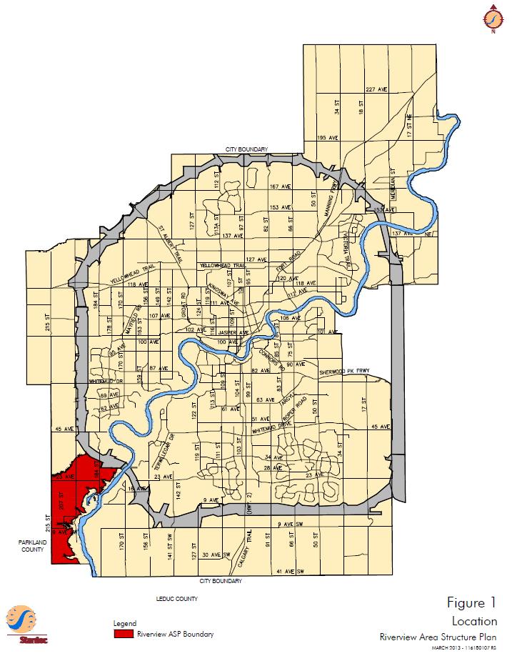
71 65
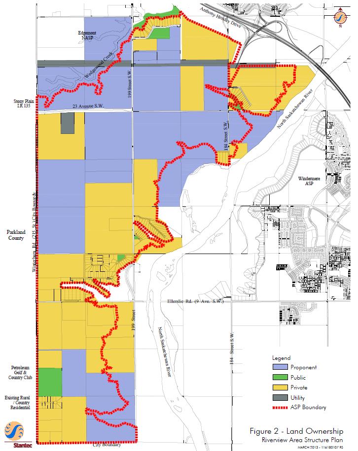
72 66
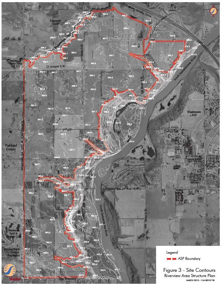
73 67
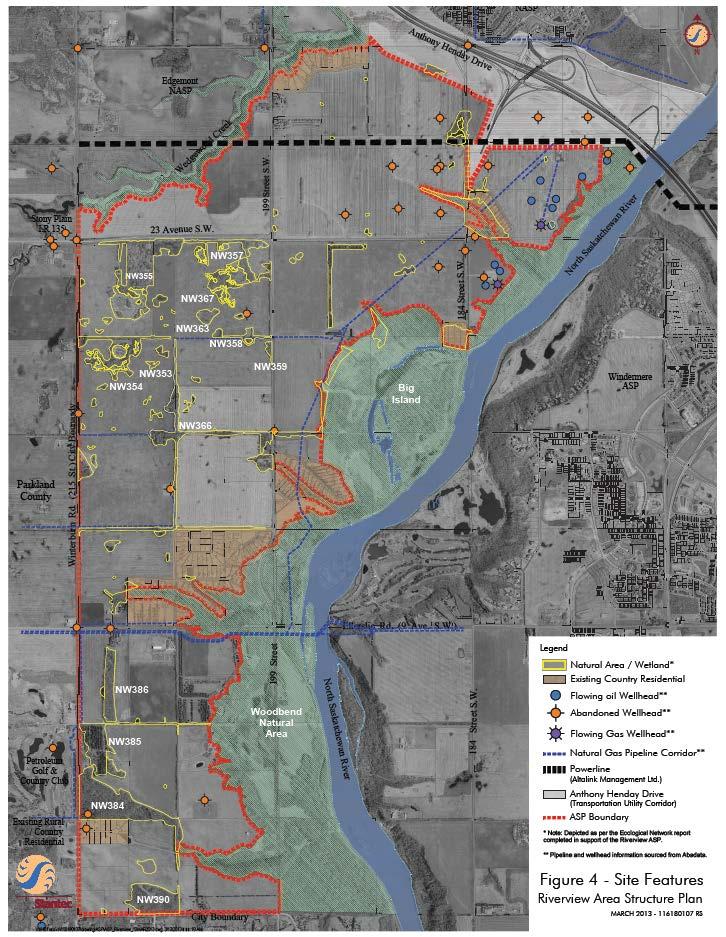
74 68

75 Bylaw Approved on September 22,

76 Bylaw Approved on February 22,

77 Bylaw Approved on September 22,

78 Bylaw Approved on September 22,

79 Bylaw Approved on September 22,

80 Bylaw Approved on September 22,

81 Bylaw Approved on September 22,

82 Bylaw Approved on September 22,

83 Bylaw Approved on September 22,

84 Bylaw Approved on February 22,
HORSE HILL AREA STRUCTURE PLAN
 HORSE HILL AREA STRUCTURE PLAN Office Consolidation September 2015 Prepared by: Current Planning Branch Sustainable Development Department City of Edmonton Bylaw 16353, as amended, was adopted by Council
Edgemont Neighbourhood Area Structure Plan
 Edgemont Neighbourhood Area Structure Plan Office Consolidation May 2017 Prepared by: Current Planning Branch Sustainable Development City of Edmonton Bylaw 15717 was adopted by Council in May 2011. In
Decoteau Area Structure Plan
 Decoteau Area Structure Plan Office Consolidation July 2015 Prepared by: Current Planning Branch Sustainable Development City of Edmonton Bylaw 17011 (as amended) was adopted by Council in July, 2015.
Chappelle Neighbourhood Area Structure Plan
 Chappelle Neighbourhood Area Structure Plan Office Consolidation September 2017 Prepared by: City Planning Urban Form and Corporate Strategic Development City of Edmonton Bylaw 14779 was adopted by Council
Central and East Neighbourhoods - Hermitage Outline Plan
 Central and East Neighbourhoods - Hermitage Outline Plan Office Consolidation September 2013 Prepared by: Planning and Policy Services Branch Planning and Development Department City of Edmonton The Central
Cy Becker Neighbourhood Structure Plan
 Cy Becker Neighbourhood Structure Plan Office Consolidation May 2013 Prepared by: Current Planning Branch Sustainable Development City of Edmonton Bylaw 15747, as amended, was adopted by Council in July
Stillwater Neighbourhood Structure Plan
 SCHEDULE "C" Stillwater Neighbourhood Structure Plan Prepared for: Walton Development and Management LP Mattamy Homes Sunwapta Holdings Corp. Prepared by: Stantec Consulting Ltd. 1161102460 Final Submission
Keswick Neighbourhood Structure Plan
 Keswick Neighbourhood Structure Plan Office Consolidation January 2018 Prepared by: City of Edmonton Bylaw 15514 was adopted by Council in July 2010. In January 2018 this document was consolidated by virtue
HAYS RIDGE NEIGHBOURHOOD AREA STRUCTURE PLAN
 Melcor Developments Ltd. HAYS RIDGE NEIGHBOURHOOD AREA STRUCTURE PLAN CONSOLIDATED APRIL 2012 Hays Ridge Neighbourhood Area Structure Plan Office Consolidation April 2012 Prepared by: Current Planning
CITY COUNCIL AGENDA REPORT
 CITY COUNCIL AGENDA REPORT Subject: COUNCIL MOTION LRT ALIGNMENT REMOVAL FROM THE TRANSPORTATION MASTER PLAN On February 10, 2016 Councillor Hughes provided notice in accordance with Section 23 of Procedure
Charlesworth Neighbourhood Structure Plan
 Charlesworth Neighbourhood Structure Plan Office Consolidation May 2016 Prepared by: City Planning Branch Sustainable Development Department City of Edmonton Bylaw 14010, as amended, was adopted by Council
Heritage Valley Neighbourhood 12 Neighbourhood Area Structure Plan
 Heritage Valley Neighbourhood 12 Neighbourhood Area Structure Plan Office Consolidation August 2011 Prepared by: Current Planning Branch Sustainable Development City of Edmonton Bylaw 15845 was adopted
LAND USE AMENDMENT CORNERSTONE (WARD 3) 60 STREET NE AND COUNTRY HILLS BOULEVARD NE MAP 26NE BYLAW 22D2017
 60 STREET NE AND COUNTRY HILLS BOULEVARD NE MAP 26NE BYLAW 22D2017") Page 1 of 14 EXECUTIVE SUMMARY This Land Use Amendment application covers an area of 43.76 hectares ± (108.14 acres ±) located in northeast Calgary, bound by Country Hills Boulevard NE to the south and
Page 1 of 14 EXECUTIVE SUMMARY This Land Use Amendment application covers an area of 43.76 hectares ± (108.14 acres ±) located in northeast Calgary, bound by Country Hills Boulevard NE to the south and
MAYFIELD WEST SECONDARY PLAN PHASE 2
 MAYFIELD WEST SECONDARY PLAN PHASE 2 Public Open House #3 February 25, 2010 Draft Preferred Land Use Scenario TOWN OF CALEDON PLANNING & DEVELOPMENT DEPARTMENT Open House Agenda TOWN OF CALEDON 1. Welcome
Westwind Developments Ltd. PIONEER LANDS AREA STRUCTURE PLAN - PROPOSED AMENDMENT
 FEBRUARY 2013 TABLE OF CONTENTS 1.0 BACKGROUND... 1 1.1 Amendment... 1 2.0 LOCATION & CONTEXT... 2 2.1 Land Ownership... 2 3.0 POLICY CONTEXT... 3 3.1 Municipal Development Plan... 3 3.2 Capital Region
Land Use Amendment in Southwood (Ward 11) at and Elbow Drive SW, LOC
 at and Elbow Drive SW, LOC") 2018 November 15 Page 1 of 10 EXECUTIVE SUMMARY This land use amendment application was submitted by Rick Balbi Architect on 2017 August 31 on behalf of Sable Developments Ltd, and with authorization from
2018 November 15 Page 1 of 10 EXECUTIVE SUMMARY This land use amendment application was submitted by Rick Balbi Architect on 2017 August 31 on behalf of Sable Developments Ltd, and with authorization from
TOWN OF BRUDERHEIM Report to the capital region board
 TOWN OF BRUDERHEIM Report to the capital region board Introduction to the Town of Bruderheim Municipal Development Plan amendment and Relation to the CRB Evaluation Criteria 02 march 2017 1 Introduction
Hawks Ridge Neighbourhood Structure Plan
 Hawks Ridge Neighbourhood Structure Plan Office Consolidation June 2014 Prepared by: Current Planning Branch Sustainable Development City of Edmonton Bylaw 15547 was adopted by Council in September 13,
Stewart Greens Neighbourhood Structure Plan
 Stewart Greens Neighbourhood Structure Plan Office Consolidation June 2017 Prepared by: Planning and Policy Services Branch Planning and Development Department City of Edmonton Bylaw 14674, as amended,
The Hamptons Neighbourhood Structure Plan
 The Hamptons Neighbourhood Structure Plan Office Consolidation December 2014 Prepared by: City Planning City of Edmonton Bylaw 11751, was adopted by Council in June 1998. In December 2014, this document
LAND USE AMENDMENT CORNERSTONE (WARD 3) COUNTRY HILLS BOULEVARD AND STONEY TRAIL NE BYLAW 9D2017
 COUNTRY HILLS BOULEVARD AND STONEY TRAIL NE BYLAW 9D2017") Page 1 of 12 EXECUTIVE SUMMARY This Land Use Amendment application covers an area of 54.92 hectares ± (135.71 acres ±) located in northeast Calgary, bound by Country Hills Boulevard NE to the north and
Page 1 of 12 EXECUTIVE SUMMARY This Land Use Amendment application covers an area of 54.92 hectares ± (135.71 acres ±) located in northeast Calgary, bound by Country Hills Boulevard NE to the north and
4 Sustainability and Growth Management
 4 Sustainability and Growth Management Introduction Traditionally, has assumed growth and development with limited consideration for the long-term negative social, environmental or economic impacts on
Ambleside Neighbourhood Structure Plan
 Ambleside Neighbourhood Structure Plan Office Consolidation May 2016 Prepared by: City Planning Sustainable Development City of Edmonton Bylaw 14057 was adopted by Council in July 2005. In May 2016, this
ADMINISTRATION RECOMMENDATION 2016 November 03. That Calgary Planning Commission recommends APPROVAL of the proposed Land Use Amendment.
 Page 1 of 12 EXECUTIVE SUMMARY This Land Use Amendment application covers an area of 75.76 hectares ± (187.20 acres ±) located in northeast Calgary, bound by Stoney Trail NE to the north, 128 Avenue NE
edmonton.ca/ribbonofgreen #ribbonofgreen
 WHAT IS THE RIBBON OF GREEN? The Ribbon of Green is Edmonton s entire river valley and ravine system. The Ribbon of Green (2018) Project will provide strategic guidance for the southwest and northeast
Starling Neighbourhood Structure Plan
 Starling Neighbourhood Structure Plan Office Consolidation April 2017 PREPARED BY: CURRENT PLANNING BRANCH SUSTAINABLE DEVELOPMENT DEPARTMENT CITY OF EDMONTON Bylaw 15461 was adopted by Council in August
WINTERBURN INDUSTRIAL AREA STRUCTURE PLAN
 OCTOBER 2009 Winterburn Industrial Area Structure Plan Office Consolidation November 2012 Prepared by: Current Planning Branch Sustainable Development City of Edmonton Bylaw 15356, was adopted by Council
NORTHEAST RIVER CROSSING FUNCTIONAL PLANNING STUDY
 WELCOME Northeast River Crossing Functional Planning Study Phase 2 Public Meeting 4 to 8 PM Informal drop-in format and discussion tables Meeting Purpose Introduce the Northeast River Crossing Functional
GATEWAY AREA STRUCTURE PLAN
 CHESTERMERE GATEWAY AREA STRUCTURE PLAN COMMUNITY OPEN HOUSE SEPTEMBER 22 nd, 2015 PLAN AREA ± 512 hectares (± 1,265 acres) GATEWAY LOCATION UNDEVELOPED LANDS PRESENT AGRICULTURAL USE REGIONAL LAND USE
PLAN ADOPTION AND PLAN AMENDMENT APPLICATION KINGLET GARDENS NEIGHBOURHOOD STRUCTURE PLAN BIG LAKE AREA STRUCTURE PLAN
 Attachment 2 File: LDA13-0086 Kinglet Gardens September 19, 2016 PLAN ADOPTION AND PLAN AMENDMENT APPLICATION KINGLET GARDENS NEIGHBOURHOOD STRUCTURE PLAN BIG LAKE AREA STRUCTURE PLAN This application
City of Grande Prairie Development Services Department
 City of Grande Prairie Development Services Department ROYAL OAKS NORTH OUTLINE PLAN OP-07-03 NW 35-71-6 W6M May 7, 2007 Royal Oaks North Outline Plan TABLE OF CONTENTS 1.0 INTRODUCTION........ 3 1.1 Purpose
Heritage Valley Town Centre Neighbourhood Area Structure Plan
 Heritage Valley Town Centre Neighbourhood Area Structure Plan Office Consolidation March 2011 Prepared by: Current Planning Branch Planning and Development Department City of Edmonton Bylaw 15296 was adopted
OP Council Resolution June 16, Planning and Development Services
 OP-08-01 Council Resolution June 16, 2008 Planning and Development Services Kingsgate Landing Outline Plan Table of Contents 1.0 Introduction 1 1.1 Purpose of Plan 1 1.2 Plan Area Location 1 1.3 Ownership
Official Plan Review
 Official Plan Review Summary Report - The Built Environment August 2014 Part 1: Introduction Planning for a healthy, prosperous and sustainable community is an important goal for our municipality. From
North Oakville East Parks Facilities Distribution Plan. November, 2009
 North Oakville East November, 2009 POLICY CONTEXT 1) Purpose a) The purpose of this document is to be a guide for the location, configuration, design and development of the parks system for the North Oakville
AREA REDEVELOPMENT PLAN THE WAY WE GROW
 AREA REDEVELOPMENT PLAN THE WAY WE GROW Office Consolidation June 2014 Submitted to the City of Edmonton Planning & Development Department By: Edmonton, AB T5G 0Y5 Phone 780 482-4813 Fax 780 488-4566 Email:
Municipal Development Plan Update Urban Service Area and Hamlets
 ENCLOSURE 1 Municipal Development Plan Update Urban Service Area and Hamlets Priorities Committee January 24, 2017 MUNICIPAL DEVELOPMENT PLAN UPDATE SHAPING OUR FUTURE MDP Update - Agenda MDP Update Public
Mayliewan Neighbourhood Structure Plan Neighbourhood 7 of the Edmonton North Area Structure Plan
 Mayliewan Neighbourhood Structure Plan Neighbourhood 7 of the Edmonton North Area Structure Plan Office Consolidation November 2008 Prepared by: Planning and Policy Services Branch Planning and Development
Complete Neighbourhood Guidelines Review Tool
 Complete Neighbourhood Guidelines Review Tool Prepared By: City of Regina Planning Department October 2014 Page 1 of 14 Community Development Review Checklist for Secondary Plans and Concept Plans The
Municipal Development Plan 2013
 UNIQUELY STONY PLAIN: Municipal Development Plan 2013 Quick Reference Guide What is a Municipal Development Plan (MDP)? The Town s highest-level planning document Sets the long-term vision and key themes
TERMS OF REFERENCE FOR THE PREPARATION AND AMENDMENT OF RESIDENTIAL AREA STRUCTURE PLANS
 Attachment 3 TERMS OF REFERENCE FOR THE PREPARATION AND AMENDMENT OF RESIDENTIAL AREA STRUCTURE PLANS Prepared by: Planning and Development Department Version 5 (2010) TABLE OF CONTENTS 1 INTRODUCTION
Streets for People, Place-Making and Prosperity. #TOcompletestreets
 COMPLETE STREETS FOR TORONTO Streets for People, Place-Making and Prosperity COMPLETE STREETS: A NEW APPROACH A Complete Streets design approach considers the needs of all users people who walk, bicycle,
ELLERSLIE AREA STRUCTURE PLAN
 ELLERSLIE AREA STRUCTURE PLAN Office Consolidation January 2017 Prepared by: City Planning Sustainable Development City of Edmonton Bylaw 11870, as amended, was adopted by Council in January 1999. In January
10.0 Open Space and Public Realm
 10.0 Open Space and Public Realm 10.0 Open Space and Public Realm The Public Open Space System is comprised of: outdoor spaces available for public use that are either publicly owned (e.g., parks and
URBAN DESIGN BRIEF URBAN DESIGN BRIEF 721 FRANKLIN BLVD, CAMBRIDGE August 2018
 URBAN DESIGN BRIEF URBAN DESIGN BRIEF 721 FRANKLIN BLVD, CAMBRIDGE August 2018 DESIGN BRIEF CONTENTS PART A 1.0 INTRODUCTION 2.0 DESCRIPTION & ANALYSIS OF SITE CONTEXT 3.0 DESIGN CONSTRAINTS AND OPPORTUNITIES
Brampton. Secondary Plan. Review. Bram West. A New Direction in Planning & Public Consultation
 Brampton Bram West Secondary Plan Review A New Direction in Planning & Public Consultation Introduction The Bram West Secondary Plan Review offers an important opportunity for the community to define a
1.0 PLANNING MARKHAM S FUTURE CONTENTS
 1-1 Planning Markham s Future 1.0 PLANNING MARKHAM S FUTURE CONTENTS 1.1 THE PURPOSE OF THE OFFICIAL PLAN 1.2 THE MARKHAM CONTEXT 1.3 THE REGULATORY CONTEXT 1.3.1 Province of Ontario 1.3.2 York Region
Welcome to the Oakridge Centre Open House
 Welcome to the Oakridge Centre Open House Why is the City hosting this event? This open house is to inform you of a rezoning application submitted to the City of Vancouver to amend the existing CD-1 (Comprehensive
Ten Mile Creek Planning Area
 PLANNING AREA POLICIES TEN MILE CREEK Ten Mile Creek Planning Area Location and Context The Ten Mile Creek Planning Area ( Ten Mile Creek area ) is located south of the current Boise AOCI, generally south
Outline Plan in Belvedere (Ward 9) at Street SE, LOC (OP)
 at Street SE, LOC (OP)") 2018 October 04 Page 1 of 12 EXECUTIVE SUMMARY This outline plan application was submitted by B&A Planning Group on 2016 July 15, on behalf of Tristar Communities Inc. for 50.14 hectares (123.89 acres)
2018 October 04 Page 1 of 12 EXECUTIVE SUMMARY This outline plan application was submitted by B&A Planning Group on 2016 July 15, on behalf of Tristar Communities Inc. for 50.14 hectares (123.89 acres)
THE CITY OF SPRUCE GROVE BYLAW C PIONEER LANDS AREA STRUCTURE PLAN AMENDMENT
 THE CITY OF SPRUCE GROVE BYLAW C-797-11 PIONEER LANDS AREA STRUCTURE PLAN AMENDMENT WHEREAS, pursuant to the Municipal Government Act, R.S.A., 2000, c.m-26, a municipality shall adopt Area Structure Plans
Windermere. Area Structure Plan
 Windermere Area Structure Plan A vibrant and sustainable community in southwest Edmonton, surrounded by the beautiful North Saskatchewan River and Whitemud Creek Ravine, well served by modern conveniences.
DESIGN NG. New Neighbourhoods Guidelines for Edmonton s Future Residential Communities THE CITY OF
 ! DESIGN NG New Neighbourhoods Guidelines for Edmonton s Future Residential Communities THE CITY OF Document Overview About the Document This performance-based guidelines document establishes a collective
CONTENTS 8.0 LAND USE 8.1 GENERAL LAND USE 8.2 RESIDENTIAL 8.3 MIXED USE 8.4 COMMERCIAL 8.5 EMPLOYMENT LANDS
 8-2 Land Use 8.0 LAND USE CONTENTS 8.1 GENERAL LAND USE 8.1.1 Uses provided for in all Land Use Designations 8.1.2 Uses prohibited in Hazardous Lands, Hazardous Sites and Special Policy Areas 8.1.3 Uses
ROAD CLOSURE AND LAND USE AMENDMENT SILVER SPRINGS (WARD 1) NORTHEAST OF NOSEHILL DRIVE NW AND SILVER SPRINGS ROAD NW BYLAWS 2C2018 AND 29D2018
 NORTHEAST OF NOSEHILL DRIVE NW AND SILVER SPRINGS ROAD NW BYLAWS 2C2018 AND 29D2018") Page 1 of 19 EXECUTIVE SUMMARY This application proposes redesignating two parcels in the community of Silver Springs from Special Purpose Future Urban Development (S-FUD) District and undesignated road
Page 1 of 19 EXECUTIVE SUMMARY This application proposes redesignating two parcels in the community of Silver Springs from Special Purpose Future Urban Development (S-FUD) District and undesignated road
Further input invited as Colchester Growth Strategy nears final phase
 IUE 3 / NOVEMBER 2015 Further input invited as Colchester Growth trategy nears final phase trathcona County is seeking public feedback as it enters the final phase of work on a Growth Management trategy
ELK GROVE GENERAL PLAN VISION
 2-1 CHAPTER 2: 2-2 CREATING OUR The Community Vision for Elk Grove, expressed through a Vision Statement and a series of Supporting Principles, is a declaration of the kind of community that Elk Grove
JASPER PLACE. Area Redevelopment Plan
 JASPER PLACE Area Redevelopment Plan Executive Summary Jasper Place is an established community where people live, work and play. The Jasper Place Area Redevelopment Plan (ARP) provides a tool to help
City of Grande Prairie Development Services Department KENNEDY DEVELOPMENTS LTD. OUTLINE PLAN OP-09-01
 City of Grande Prairie Development Services Department KENNEDY DEVELOPMENTS LTD. OUTLINE PLAN OP-09-01 July 27, 2009 TABLE OF CONTENTS 1.0 Introduction... 1 1.1 Plan Area Location & Context... 1 1.2 Ownership
Canossa NSP. Office Consolidation August Prepared by: Planning and Policy Services Branch Planning and Development Department City of Edmonton
 Canossa NSP Office Consolidation August 2004 Prepared by: Planning and Policy Services Branch Planning and Development Department City of Edmonton Bylaw 7613 (as amended) was adopted by Council October
This application has been applied for with support of an Outline Plan to provide the technical details for the site s development.
 Page 1 of 13 EXECUTIVE SUMMARY This application consists of a Land Use Amendment application proposing redesignation from Special Purpose Future Urban Development (S-FUD) District to an assortment of multiresidential,
Schonsee Neighbourhood Structure Plan of the Edmonton North Area Structure Plan
 Schonsee Neighbourhood Structure Plan of the Edmonton North Area Structure Plan Office Consolidation September 2010 Prepared by: Planning and Policy Services Branch Planning and Development Department
2040 LUP is a part of the Comprehensive Plan and carries the same legal authority. Economic Challenges
 1.1. Guiding Anchorage s Growth Where will new residents settle over the next two decades? Where will people work, shop, and play? Will there be enough room to grow? How will Anchorage look? Will growth
S o u t h C e n t r a l O u t l i n e P l a n. Leduc Business Park. North Leduc Industrial Area Structure Plan C it y of Led u c.
 Leduc Business Park North Leduc Industrial Area Structure Plan C it y of Led u c Prepared for Farm Air Properties Inc. January, 2007 Table of Contents Page Number 1.0 Purpose of Plan and Definition of
Bylaw C-1262 Adopted February 6, Planning and Development Department
 Bylaw C-1262 Adopted February 6, 2012 Planning and Development Department CITY OF GRANDE PRAIRIE BYLAW C-1262 A Bylaw to adopt the Brookfield Neighbourhood Outline Plan THE MUNICIPAL COUNCIL OF THE CITY
Official Plan Review: Draft Built Form Policies
 PG.30.1 REPORT FOR ACTION Official Plan Review: Draft Built Form Policies Date: May 15, 2018 To: Planning and Growth Management Committee From: Chief Planner and Executive Director, City Planning Division
Regional Context Statement
 Regional Context Statement REGIONAL CONTEXT STATEMENT 3. REGIONAL CONTEXT STATEMENT In 1995, the Provincial Government passed into law the Growth Strategies Act. The purpose of this provincial initiative
Maple Ridge Industrial Area Structure Plan
 Maple Ridge Industrial Area Structure Plan Bylaw 15357, March 8, 2010 Office Consolidation May 2010 Prepared by: Planning and Policy Services Branch Planning and Development Department City of Edmonton
V. Vision and Guiding Principles
 V. Vision and Guiding Principles The Master Plan for the Powers Ferry Corridor seeks a foundation in the desires of the community. At times, various elements of the community offered opposing viewpoints,
Municipal Development Plan. Summer Village of ROCHON SANDS. Bylaw #241-18
 Municipal Development Plan Summer Village of ROCHON SANDS Bylaw #241-18 TABLE OF CONTENTS PART ONE: BACKGROUND AND PURPOSE 3 SECTION 1: BACKGROUND 3 SECTION 2: GOALS AND POLICIES 3 PART TWO: PHYSICAL ENVIRONMENT
PSRC REVIEW REPORT & CERTIFICATION RECOMMENDATION
 PSRC REVIEW REPORT & CERTIFICATION RECOMMENDATION KITSAP COUNTY COUNTYWIDE PLANNING POLICIES July 2, 2012 BACKGROUND A major emphasis of the Washington State Growth Management Act (GMA) is the need to
THE WAY WE GROW TERMS OF REFERENCE FOR THE PREPARATION AND AMENDMENT OF NEIGHBOURHOOD STRUCTURE PLANS IN EDMONTON S URBAN GROWTH AREAS APRIL 2014
 THE WAY WE GROW TERMS OF REFERENCE FOR THE PREPARATION AND AMENDMENT OF NEIGHBOURHOOD STRUCTURE PLANS IN EDMONTON S URBAN GROWTH AREAS APRIL 2014 TABLE OF CONTENTS 1. INTRODUCTION 1 1.1 Goal of Terms of
Gold Line Bus Rapid Transit Transit Oriented Development (BRTOD) Helmo Station Area Plan
 Helmo Station Area Plan") Appendix F Gold Line Bus Rapid Transit Transit Oriented Development (BRTOD) Helmo Station Area Plan Introduction and Purpose of the Plan The Gold Line Bus Rapid Transit facility is an eleven-mile dedicated
Appendix F Gold Line Bus Rapid Transit Transit Oriented Development (BRTOD) Helmo Station Area Plan Introduction and Purpose of the Plan The Gold Line Bus Rapid Transit facility is an eleven-mile dedicated
THE CORPORATION OF THE TOWN OF OAKVILLE BY-LAW NUMBER
 THE CORPORATION OF THE TOWN OF OAKVILLE BY-LAW NUMBER 20012-08530 A by-law to adopt an amendment to the Official Plan of the Oakville Planning Area (Official Plan Amendment 198) Land North of Dundas Street.
Bylaw No. B-03/2011 Adopted by Airdrie City Council February 21, 2012
 COOPER S CROSSING STAGE 4 Neighbourhood Structure Plan City of Airdrie WESTMARK HOLDINGS LTD. Bylaw No. B-03/2011 Adopted by Airdrie City Council February 21, 2012 CONSULTANTS: LAND USE PLANNING: Southwell
LAND USE AMENDMENT DOWNTOWN COMMERCIAL CORE (WARD 7) MACLEOD TRAIL SE AND 5 AVENUE SE BYLAW 254D2017
 MACLEOD TRAIL SE AND 5 AVENUE SE BYLAW 254D2017") Page 1 of 10 EXECUTIVE SUMMARY This Land Use Amendment application seeks to redesignate a full downtown block (currently the YWCA site) from a Direct Control based on the CM-2 District (Land Use Bylaw
Page 1 of 10 EXECUTIVE SUMMARY This Land Use Amendment application seeks to redesignate a full downtown block (currently the YWCA site) from a Direct Control based on the CM-2 District (Land Use Bylaw
WEST HILL BUSINESS PARK AREA STRUCTURE PLAN
 MUNICIPAL DISTRICT OF PEACE NO. 135 WEST HILL BUSINESS PARK AREA STRUCTURE PLAN Prepared by: TABLE OF CONTENTS 1.0 Introduction... 1 1.1 Purpose of Plan........ 1 1.2 Plan Area..... 1 1.3 Existing Conditions...
Ebbers Neighbourhood Area Structure Plan
 Ebbers Neighbourhood Area Structure Plan Office Consolidation November 2016 Prepared by: City Planning Branch Sustainable Development City of Edmonton Bylaw 14079, was adopted by Council in February 2006.
Summerside Neighbourhood Structure Plan
 Summerside Neighbourhood Structure Plan Office Consolidation July 2012 Prepared by: Current Planning Branch Sustainable Development City of Edmonton Bylaw 12112 (as amended) was adopted by Council on September
COMMUNITY SUSTAINABILITY AND ENVIRONMENTAL MASTER PLAN IMPLEMENTATION UPDATE
 Attachment 1 COMMUNITY SUSTAINABILITY AND ENVIRONMENTAL MASTER PLAN IMPLEMENTATION UPDATE Priorities and Key Initiatives Committee May 2013 Page E-1 How we grow Goal 2: To ensure sustainable development
SECTION E. Realizing the Plan
 SECTION E Realizing the Plan 60 DESIGN REGINA - OFFICIAL COMMUNITY PLAN SECTION E Realizing the Plan Design Regina has been an ambitious plan-making exercise, with a high level of community, stakeholder,
Report to: Development Services Committee Report Date: April 24, 2017
 SUBJECT: Cornell Rouge National Urban Park Gateway - Report on Design Charrette and Next Steps PREPARED BY: Lilli Duoba, MES, MCIP, RPP, Manager, Natural Heritage (ext. 7925) REVIEWED BY: Marg Wouters,
TO: Mayor & Council DATE: April 12, The Planning and Development Department and the Engineering Department recommend that Council:
 CORPORATE REPORT NO: R080 COUNCIL DATE: April 12, 2010 REGULAR COUNCIL TO: Mayor & Council DATE: April 12, 2010 FROM: SUBJECT: General Manager, Planning and Development General Manager, Engineering Neighbourhood
PORT WHITBY COMMUNITY
 PORT WHITBY COMMUNITY SECONDARY PLAN UPDATE COMMUNITY IMPROVEMENT PLAN URBAN DESIGN GUIDELINES September 2015 DRAFT PROPOSED AMENDMENT NUMBER # to the Whitby Official Plan PURPOSE: The intent of this Amendment
University of Saskatchewan CAMPUS MASTER PLAN. Senate Meeting Preliminary Presentation. April 21, 2018 DIALOG ECS DA WATT
 University of Saskatchewan CAMPUS MASTER PLAN Senate Meeting Preliminary Presentation April 21, 2018 DIALOG ECS DA WATT project process presentation agenda Stakeholder Engagement Project Control phase1
Coliseum Station Area Area Redevelopment Plan. Public Engagement #1 June 12, 2017
 Coliseum Station Area Area Redevelopment Plan Public Engagement #1 June 12, 2017 Welcome Engagement Purpose Introduce the project Share information Gather input Project Updates & Newsletter edmonton.ca/coliseumplan
CITY COUNCIL AGENDA REPORT
 CITY COUNCIL AGENDA REPORT Subject: DESIGNATED FLOOD LINE CARROT CREEK Recommendation(s) That Administration bring forward a Land Use Bylaw amendment in October 2014 establishing the Designated Flood Line
ADMINISTRATION RECOMMENDATION(S) 2018 January 25. That Calgary Planning Commission recommend APPROVAL of the proposed Land Use Amendment.
 2018 January 25. That Calgary Planning Commission recommend APPROVAL of the proposed Land Use Amendment.") Page 1 of 9 EXECUTIVE SUMMARY This land use amendment proposes to redesignate a parcel from DC Direct Control District to Multi-Residential Contextual Grade-Oriented (M-CG) District to allow for multi-residential
Page 1 of 9 EXECUTIVE SUMMARY This land use amendment proposes to redesignate a parcel from DC Direct Control District to Multi-Residential Contextual Grade-Oriented (M-CG) District to allow for multi-residential
Whitemarsh Comprehensive Plan Update: Housing & Land Use. Public Workshop #3: September 20, 2018
 Whitemarsh Comprehensive Plan Update: Housing & Land Use Public Workshop #3: September 20, 2018 Agenda Welcome Process Recap What We ve Heard The Plan Framework Review of Recommended Actions Land Use Housing
1.0 Purpose of a Secondary Plan for the Masonville Transit Village
 Report to Planning and Environment Committee To: Chair and Members Planning & Environment Committee From: John M. Fleming Managing Director, Planning and City Planner Subject: Masonville Transit Village
McCowan Precinct Plan Study Background & Deliverables
 1 DRAFT & WITHOUT PREJUDICE McCowan Precinct Plan Study Background & Deliverables In September, 2011, City Planning (Scarborough District) began a study of an area within the Scarborough Centre, identified
COMMISSION ACTION FORM
 ITEM #: 6 DATE: 09-06-17 COMMISSION ACTION FORM REQUEST: Introduction and Initial Review of Proposed Amendments to the Ames Urban Fringe Future Land Map for the North Growth Gap Area BACKGROUND INFORMATION:
Staff Report and Recommendation
 Community Planning and Development Planning Services 201 W. Colfax Ave., Dept. 205 Denver, CO 80202 p: 720.865.2915 f: 720.865.3052 www.denvergov.org/cpd TO: City Council Neighborhoods and Planning Committee
Introduction. Chapter 1. Purpose of the Comprehensive Plan Plan Organization Planning Process & Community Input 1-1
 Chapter 1 Introduction Lakewood 2025: Moving Forward Together Purpose of the Comprehensive Plan Plan Organization Planning Process & Community Input 1-1 Purpose of the Comprehensive Plan The Comprehensive
Downtown Whitby Action Plan
 Downtown Whitby Action Plan Final Report October 2016 Table of Contents Introduction 1 Public Consultation 2 Walkability 3 Downtown Whitby Walkability Map 4 Vision 5 Goal & Objectives 6 Objective 1 7 Objective
6 Growth Management Challenges and Opportunities
 6 Growth Management Challenges and Opportunities The Town has established a goal of attaining a 50% participation rate with respect to employment opportunities versus residential population. The Town s
CITY OF VAUGHAN EXTRACT FROM COUNCIL MEETING MINUTES OF NOVEMBER 15, 2016
 Item 11, Report No. 38, of the Committee of the Whole, which was adopted without amendment by the Council of the City of Vaughan on November 15, 2016. Regional Councillor Di Biase declared an interest
3. Endorse the LRT vision in transforming Surrey into Connected-Complete-Livable communities, and more specifically, the official vision statement:
 CORPORATE REPORT NO: R038 COUNCIL DATE: February 20, 2017 REGULAR COUNCIL TO: Mayor & Council DATE: February 16, 2017 FROM: General Manager, Engineering FILE: 8740-01 SUBJECT: Surrey Light Rail Transit
Chapter 2: Vision, Goals and Strategies
 Chapter 2: Vision, Goals and Lake Elmo Today & Tomorrow Comprehensive Plan 2040 2 VISION, GOALS & STRATEGIES - DRAFT 4-6-2018 INTRODUCTION Comprehensive Plan Purpose Perhapse the most important objective
13 THORNHILL YONGE STREET STUDY IMPLEMENTATION CITY OF VAUGHAN OPA 669 AND TOWN OF MARKHAM OPA 154
 13 THORNHILL YONGE STREET STUDY IMPLEMENTATION CITY OF VAUGHAN OPA 669 AND TOWN OF MARKHAM OPA 154 The Planning and Economic Development Committee recommends the adoption of the recommendations contained