Charlestown Waterfront Assessment: Creating Connections
|
|
|
- Silvester Sims
- 5 years ago
- Views:
Transcription
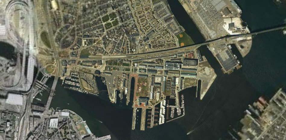
1 Charlestown Waterfront Assessment: Creating Connections Marisa Arpels Luis Montoya Rodrigo Diaz Sabra Loewus Cyd McKenna

2 Charlestown = 1.5 miles USS Constitution 3 miles
3 Creating Connections Between Charlestown residents and the waterfront Between the Greater Boston Area and the Navy Yard Between the USS Constitution and Yard s End Between the past and present
4 Recommendations Increase access to the Navy Yard Develop attractions to create a critical mass along the waterfront Establish an influential organization to coordinate stakeholders and lead the process
5 Bringing People Bringing people to the Navy Yard Water shuttles from Lovejoy Wharf, Long Wharf and South Boston Buses from Boston and Charlestown Duck tour stop
6 Bringing People Bringing people through the Navy Yard Improve pedestrian gateways from Charlestown Establish a network of special attractions Charlestown Recreational hub Gateways
7 Bringing people Expand Courageous Sailing Allow access to the water Provide kayak rentals, underwater exploration and other low impact water activities
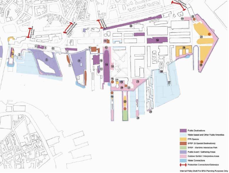
8 A Special Destination
9 Loop 5: The Yard s End Create a special attraction To draw visitors to the Yard s End To complement the other thematic loops
10 Create an entity that: Reports to the Mayor Implementation Liaises between Charlestown community and the city Leads decision-making Coordinates maintenance of public spaces Facilitates programming
11 Summary Access Increase transportation to waterfront Increase connections throughout waterfront Attractions Commit to special destination on Yard s End Initiate outreach to find developer(s) Implementation Create entity with authority Lead decision-making and coordination
12
13
14 Navy Yard Planning History 1974 Transfer of Navy Yard from US Government to BRA 1978 Navy Yard Master Plan 1990 Harbor Plan 1991 Double Interpretative Loop 2006 Charlestown Navy Yard Waterfront Activation Plan
15 Past Plan History 1990 Harbor Plan Primacy of public access to water edge: 1/3 waterfront for open space and recreation Improve and expand open space Connect Navy Yard to surrounding community Preserve Yard s historic character New waterfront housing 1991 Double Interpretative Loop Plan 2 nodes along waterfront: USS Constitution and Aquarium small FPA spaces in between
16 State requirements Massachusetts General Law Chapter 91 Facilities of Public Accommodation or FPAs : State wide waterway regulation developed by the Department of Environmental Protection. The goal of the regulations was to protect public navigation rights, largely focusing on maritime uses. The rule supports the idea that the public has the right to access tidelands to fulfill basic needs through fishing and other water-based commercial activity.
17 State requirements Special Public Destination Facility (SPDF): Cultural facilities that would attract the public on a year-round basis, creating a vibrant area available to everyone, not just those living in the neighborhood. The term is also connected to a 1991 planning effort for the Charlestown Naval Shipyard (Double Interpretive Loop Plan), which intended to use a network of SPDFs to widen public access to the more remote waterfront parcels at Yard s End. A SPDF does not have to be a large, free-standing cultural facility.
18 Controversy over Pier 5 and SPDF Lot on Pier 5 is currently slated for residential development. Under Chapter 91 and the Harbor Walk Plan, a development of this size requires a SPDF of 34,000s.f. The BRA argues that currently there is no demand for such a large SPDF and it will be difficult to find a developer for such a large space. Consequently, they have designed the current plan to break up the SPDF and distribute it around the loops.
19 Controversy over Pier 5 and SPDF The community views the break up of space as: 1. a violation of the law 2. an attempt to privatize the water front 3. sets a bad precedent for future developments on the waterfront. The break up of the SPDF seems reasonable given the location on Pier 5, but believe that the Mayor should support the creation of a large SPDF on Parcel 5 in order to create connectivity between the two ends of the Yard, and appease resident fears about the privatization of the waterfront
Waterfront Activation Plan for the Charlestown Navy Yard Public Meeting
 Waterfront Activation Plan for the Charlestown Navy Yard Public Meeting January 20, 2005 Community Partners Consultants, Inc. John Roll & Associates Ross Miller Studio The Community Partners Team Extensive
Chelsea Creek Municipal Harbor Plan
 Chelsea Creek Municipal Harbor Plan Public Meeting #1 June 11th, 2018 1 Presentation outline I. Introduction: Why are we doing this plan? II. Evolution of Chelsea Creek III. State of Chelsea Creek IV.
Request for Proposals
 Request for Proposals Charlestown Navy Yard Infrastructure Assessment Engineering Services The Boston Redevelopment Authority ( BRA )/Economic Development Industrial Corporation ( EDIC ) is issuing a Request
Agenda. Where we are in the MHP process/regulatory review MHP components Proposed MHP Next steps
 1 Agenda Where we are in the MHP process/regulatory review MHP components Proposed MHP Next steps for the Boston Redevelopment Authority MHPAC Meeting 2 Where we are in the MHP process The BRA and its
Lynn Waterfront Master Plan
 Lynn Waterfront Master Plan Public Meeting #2 December 10th, 2018 1 Project Schedule Update September 26, 2018 December 10, 2018 Development of the Master Harbor Plan Amendment and Revised Waterfront Master
Downtown Waterfront Municipal Harbor Plan Advisory Committee
 Downtown Waterfront Municipal Harbor Plan Advisory Committee Waterfront Activation and Programming Subcommittee November 1, 2013 1 Our Process 1. Solicit Ideas and Public Input a. Through charrettes Charrette
2017 Downtown Waterfront District Municipal Harbor Plan & Public Realm Activation Plan Supplement - February 16, 2018
 Harbor Garage and New England Aquarium Throughout the Downtown Waterfront planning process and the state s consultation sessions protections and assurances for the New England Aquarium s ongoing operations
North Fair Oaks Community Plan Summary and Information
 North Fair Oaks Community Plan Summary and Information WHAT IS THE NORTH FAIR OAKS COMMUNITY PLAN? The North Fair Oaks Community Plan is part of the San Mateo County General Plan, and establishes policies
Charlestown Navy Yard Community Meeting. July 6, 2016
 Charlestown Navy Yard Community Meeting AGENDA 1. Pier 4 Water Transportation Terminal Project 2. Building 108 3. Project Updates: Ropewalk, Chain Forge 4. CNY Engineering Assessment RFP 5. CNY Waterfront
1.1 WATERFRONT SEATTLE
 1.1 WATERFRONT SEATTLE Over the past few years, the City of has been actively re-imagining the future of its Central Waterfront. The imminent replacement of the Elliott Bay Seawall and removal of the Alaskan
PLAN ELEMENTS WORKSHOP. April 5, 2016
 PLAN ELEMENTS WORKSHOP April 5, 2016 needs more housing. But there is no one-size fits-all solution. Every neighborhood has its own character. In some places, density is not only appropriate it is badly
India Basin/Hunters Point Shoreline Community Workshop May 21, 2008
 India Basin/Hunters Point Shoreline Community Workshop May 21, 2008 Workshop Agenda Welcome Process Overview Context & Existing Conditions Presentation of Draft Concepts Land Use and Open Space Priorities
Fisherman s Wharf Public Realm Plan
 Fisherman s Wharf Public Realm Plan SPUR Presentation July 11, 2008 3 February 2010 WHY A PUBLIC REALM PLAN? Public Life 1900 1950 1965 2000 Mainstreet Copenhagen in 100 years From nessesary to optional
FORT POINT DOWNTOWN WATERFRONT MUNICIPAL HARBOR
 FORT POINT DOWNTOWN WATERFRONT MUNICIPAL HARBOR P L A N A MUNICIPAL HARBOR PLAN OF THE CITY OF BOSTON PHASE II SUPPLEMENT CITY OF BOSTON Thomas M. Menino Mayor Boston Redevelopment Authority Mark Maloney
Town of Cobourg Heritage Master Plan. Statutory Public Meeting
 Town of Cobourg Heritage Master Plan Statutory Public Meeting April 25 th 2016 Presentation Overview 1. Introduction 2. Project background and schedule overview 3. Review of strategic direction content
Animating the Rideau Canal December 2013
 Executive Summary Animating the Rideau Canal December 2013 Why study the Rideau Canal? The Rideau Canal has been an important part of Ottawa throughout its history, and has shaped and been shaped by the
South Boston Edison Power Plant Planning Process Report
 South Boston Edison Power Plant Planning Process Report Edison Power Plant Workshop Outcomes Over the next decade the Edison Power Plant site will undergo a transformation from an industrial relic that
RRC WATERFRONT PLANNING TOOLKIT AND GUIDELINES
 RRC WATERFRONT PLANNING TOOLKIT AND GUIDELINES The purpose of this toolkit is to provide more detail on best planning practices identified in the RRC Best Practice Evaluation Criteria Waterfront-specific
Draft Downtown Waterfront Municipal Harbor Plan
 7/20/2016 Draft Downtown Waterfront Municipal Harbor Plan FRAMEWORK MHP BACKGROUND & GOALS AMPLIFICATIONS, SUBSTITUTE PROVISIONS, & OFFSETS CHAPTER 91 LONG-TERM LICENSE FEES PREPARING FOR CLIMATE CHANGE
THE COMMUNITY-DRIVEN DESIGN PROCESS
 THE COMMUNITY-DRIVEN DESIGN PROCESS A PUBLIC DRIVEN PROCESS STEERING COMMITEE THE COMPREHENSIVE PLAN OPPORTUNITIES AND CONSTRAINTS THE COMMUNITY DRIVEN DESIGN PROCESS A Public Driven Process Beginning
PORT OF SAN FRANCISCO WATERFRONT PLAN UPDATE: PART 3
 Waterfront Planning Timeline WHAT IS THE PORT? The Port of San Francisco manages 7½ miles of the San Francisco waterfront from Fisherman s Wharf in the north to Heron s Head Park in the south. Port properties
150 Seaport Boulevard BCDC Project Summary Booklet
 150 Seaport Boulevard BCDC Project Summary Booklet Submitted by Cronin Holdings LLC March 30, 2016 150 SEAPORT BOULEVARD PROJECT SUMMARY Project Proponent: Project Proponent: Architect: Landscape Architect:
Cohasset Municipal Harbor Plan Public Meeting #1. Harriman GEI Consultants FXM Associates May 31, 2018
 Public Meeting #1 Harriman GEI Consultants FXM Associates Agenda Welcome and Introductions Planning Study: Purpose and Process Municipal Harbor Planning 101 Existing Conditions Creating a Vision for the
MARINA MARKET & WATERFRONT DEVELOPMENT STUDY PORT ARANSAS, TEXAS
 MARINA MARKET & WATERFRONT DEVELOPMENT STUDY PORT ARANSAS, TEXAS FEBRUARY 2015 PRESENTATION OUTLINE 1 2 3 4 5 6 7 REGIONAL POSITIONING SITE IMPRESSIONS PLANNING & DESIGN PRINCIPLES EXISTING IMPROVEMENTS
PROPOSED URBAN STRUCTURE
 CHAPTER 3 PROPOSED URBAN STRUCTURE PLANNING PARTNERS: CENTURY CITY URBAN DESIGN FRAMEWORK October 2005 13 THE PROPOSED URBAN STRUCTURE The urban design rationale outlined in the previous chapter provides
Subject: Intercontinental Hotel Boston (500 Atlantic Ave) Ch. 91 License # 9825
 Ch. 91 License # 9825") July 11, 2017 Ben Lynch, Waterways Program Chief Department of Environmental Protection One Winter Street Boston, Massachusetts 02108 Subject: Intercontinental Hotel Boston (500 Atlantic Ave) Ch. 91 License
July 11, 2017 Ben Lynch, Waterways Program Chief Department of Environmental Protection One Winter Street Boston, Massachusetts 02108 Subject: Intercontinental Hotel Boston (500 Atlantic Ave) Ch. 91 License
Hamilton Pier 7&8 Public Meeting and Workshop #1
 Hamilton Pier 7&8 Public Meeting and Workshop #1 May 12, 2015 May 01, 2015 Meeting Agenda 6:30 Doors Open 6:30-6:45 Review Boards 6:45-7:10 Introductions and Presentation Study Overview Policy Background
The University District envisions, in its neighborhood
 Envisioning the University District Link Light Rail in Seattle s neighborhoods CIY OF SEALE CONCEP-LEVEL SAION AREA PLANNING RECOMMENDAION RESOLUION # 30165 EXHIBI L Vision 08.2000 he University District
Connecting Key Activity Centers with High Quality Bus Service
 Connecting Key Activity Centers with High Quality Bus Service Lessons Learned from the DC Circulator Transit Development Plan April 15, 2011 1 DC Circulator Transit Development Plan Ten-year plan for development
The Master Plan Framework
 The Master Plan Framework The East Harbour Master Plan advances the development of 60 acres of former industrial lands east of the Don River. The Master Plan outlines a vision for a vibrant, transit-oriented
TOWN OF BETHLEHEM MEETING SUMMARY LOCAL WATERFRONT REVITALIZATION PROGRAM UPDATE
 TOWN OF BETHLEHEM LOCAL WATERFRONT REVITALIZATION PROGRAM UPDATE MEETING SUMMARY Purpose: LWRP Update Public Workshop #3 Date and Time: October 24, 2017, 6:00 pm - 8:00 pm Location: Town Hall, 445 Delaware
M i s s i o n B a y W a t e r f r o n t
 114 M i s s i o n B a y W a t e r f r o n t Character of the Area: The Mission Bay Waterfront extends from Pier 48 at China Basin Channel to 18th Street in the Central Basin. This area of the waterfront
The San Pedro Public Market. Redefining the Los Angeles Waterfront March 20th LA Waterfront Town Hall
 The San Pedro Public Market Redefining the Los Angeles Waterfront March 20th LA Waterfront Town Hall l JAMES CORNER FIELD OPERATIONS l ADAMSON ASSOCIATES ARCHITECTS 2018 1 The Team l JAMES CORNER FIELD
Zoning and Development Considerations in the Boothbay Harbor Maritime/Water Dependent District
 Zoning and Development Considerations in the Boothbay Harbor Maritime/Water Dependent District Bob Faunce Lincoln County Planner Lincoln County Regional Planning Commission Board of Selectmen and Planning
East Midtown Greenway East 53 rd 61 st Street. Community Board 8 Project Introduction November 16, 2017
 East Midtown Greenway East 53 rd 61 st Street Community Board 8 Project Introduction November 16, 2017 Agenda Overview - Development of the East Midtown Waterfront Esplanade Current East Midtown Greenway
Lower South Street/Louisa Street Charrette Final Presentation. September 22, 2009
 Lower South Street/Louisa Street Charrette Final Presentation September 22, 2009 Recap Mayor and Council called for a Charrette to engage the public on creating a vision for the Lower South Street area.
CAMPUS MASTER PLAN UPATE
 19 MAY 2016 CAMPUS MASTER PLAN UPATE Metropolitan Planning Organization AGENDA Introductions Planning Scope Observation & Analysis: Mobility Systems Campus Development Plan Mobility Planning Scenarios
The Palisades Interstate Parkway and Henry Hudson Drive designated a New Jersey State Scenic Byway, 2005
 The Palisades Interstate Parkway and Henry Hudson Drive designated a New Jersey State Scenic Byway, 2005 What are scenic byways? How Did Scenic Byways Come About? National Scenic Byways Program Administered
process of the Land Development Code to assure regional parks are available County-wide.
 GOAL 9.0. It is the goal of the Broward County Board of County Commissioners to provide safe and adequate recreation sites and facilities, including cultural art facilities, and open space to satisfy the
{Best Practices. Summary of Tools, Strategies and Best Practices from 11 Michigan Case Study Communities
 Case Studies Michigan Coastal Community Working Waterfronts { Summary of Tools, Strategies and from 11 Michigan Case Study Communities Table of Contents Zoning...2 Community and Stakeholder Collaboration
Thames River Basin Partnership Floating Workshop XVI
 Thames River Basin Partnership Floating Workshop XVI Thames River Basin Partnership The Thames River Basin Partnership is a voluntary, cooperative effort to share organizational resources and to develop
Four Big Ideas. Three Key Opportunities. Principles. Draft Place Making Master Plan. 1. The Foreshore 2. Green Links. 3.
 project background Four Big Ideas 1. The Healthy Thriving Place. An International Focus 3. Reclaiming Mooloolaba 4. The Resort Heart of the Coast In November 01 a big ideas workshop was held involving
Shoreline Master Program Town of La Conner, Washington
 Shoreline Master Program Town of La Conner, Washington Department of Ecology approval effective Adopted September 24, 2013 by Town of La Conner Ordinance No.1106 Amended May 13, 2014 by Town of La Conner
Illustration of Eastlake Farmer s Cooperative Grain Elevator. Chapter 5: implementation 5-1
 Illustration of Eastlake Farmer s Cooperative Grain Elevator Chapter 5: implementation 5-1 chapter 5: implementation Introduction The Eastlake Subarea Plan includes a wide range of recommendations intended
COASTAL CONSERVANCY. Staff Recommendation April 27, 2006 TALL SHIPS EXPOSITION File No Project Manager: Neal Fishman/Carol Arnold
 COASTAL CONSERVANCY Staff Recommendation April 27, 2006 TALL SHIPS EXPOSITION 2008 File No. 05-020 Project Manager: Neal Fishman/Carol Arnold RECOMMENDED ACTION: Authorization to disburse up to $100,000
Chapter 6. Overall Vision RECOMMENDATIONS. More Trail and Trail. Connections. Equal Access to Park. Facilities and Programs. Water Access.
 Overall Vision More Trail and Trail Connections Equal Access to Park Facilities and Programs Water Access Environment Variety Chapter 6 RECOMMENDATIONS Chapter 6 The following recommendations for park,
Corridor Vision. 1Pursue Minnehaha-Hiawatha Community Works Project. Mission of Hennepin County Community Works Program
 1Pursue Minnehaha-Hiawatha Community Works Project Minnehaha-Hiawatha Community Works is a project within the Hennepin Community Works (HCW) program. The mission of the HCW program is to enhance how the
A Vision For Miami s Twenty-first Century Parks And Public Spaces
 1 A Vision For Miami s Twenty-first Century Parks And Public Spaces Parks and Public Spaces in Miami 21 An urban renaissance is remaking the City of Miami as new residents, new visitors, and new investment
2030 Comprehensive Plan VISION STATEMENT
 RESOURCE DOCUMENT for Steering Committee Meeting #2 July 12, 2017 2030 Comprehensive Plan VISION STATEMENT Steering Committee from 2008 Established the Lauderdale s Vision as: Creating a livable, lovable
CHAPTER 8 ISSUES, CONCERNS, CONSTRAINTS AND OPPORTUNITIES
 CHAPTER 8 ISSUES, CONCERNS, CONSTRAINTS AND OPPORTUNITIES Introduction This River Conservation Plan was developed during a time of tremendous activity and effort in planning the transformation of the Delaware
I-70 Corridor Enhancement Plan
 i - Table of Contents Table of Contents Chapter I Overview Chapter II Bridge and Roadway Improvements Chapter III Landscape Enhancements Chapter IV Riparian Corridors Chapter V Showcase Missouri Plan Chapter
City Center Neighborhood Plan
 [1] City Center Neighborhood Plan As adopted by Ordinance No. 2014-09-049 and amended by Ordinance Nos. Formerly CBD Neighborhood as adopted by Ordinance No. 8868 and amended by Ordinance Nos. 8946, 9693,
Bourne Downtown Site Planning
 Prepared for: The Town of Bourne, MA In Cooperation with: Bourne Financial Development Corporation Prepared by:, Inc. June 24, 2009 Table of Contents Introduction and Summary... 1 Site Existing Conditions...
Whitemarsh Comprehensive Plan Update: Housing & Land Use. Public Workshop #3: September 20, 2018
 Whitemarsh Comprehensive Plan Update: Housing & Land Use Public Workshop #3: September 20, 2018 Agenda Welcome Process Recap What We ve Heard The Plan Framework Review of Recommended Actions Land Use Housing
PORT OF VANCOUVER WATERFRONT DEVELOPMENT. Concept Development Plan City Center Redevelopment Authority April 20, 2017
 PORT OF VANCOUVER WATERFRONT DEVELOPMENT Concept Development Plan City Center Redevelopment Authority April 20, 2017 Port History PORT ESTABLISHED 1912 TERMINAL 1 ACQUIRED 1925 GWM SIGNS LEASE 1935 HARBOR
Inspiration Port Credit. Exploring the Options Public Engagement March 26, 2013
 Inspiration Port Credit Exploring the Options Public Engagement March 26, 2013 Port Credit Port Credit Foundations Change has been happening in Port Credit for years. Source: City of Mississauga, Mississauga
STUDY AREA. Tonight s Agenda. Project Tasks Completed. Next Steps. Town of Oyster Bay Eastern Waterfront Community Vision & Revitalization Plan
 Town of Oyster Bay Eastern Waterfront Community Vision & Revitalization Plan Public Meeting January 27, 2009 Opening Remarks Presentation Tonight s Agenda Introduction Study Area Overview Public Participation
10.0 Open Space and Public Realm
 10.0 Open Space and Public Realm 10.0 Open Space and Public Realm The Public Open Space System is comprised of: outdoor spaces available for public use that are either publicly owned (e.g., parks and
DRAW SEVEN PARK RENOVATION PROJECT SOMERVILLE, MASSACHUSETTS
 DRAW SEVEN PARK RENOVATION PROJECT SOMERVILLE, MASSACHUSETTS DCR Public Meeting Monday, February 5th 6:30pm-8:30pm East Somerville Community School 50 Cross Street, Somerville, MA, 02145 Commonwealth of
Final Master Plan and Development Control Regulations
 1. INTRODUCTION CHECK LIST a. Introduction b. Table of contents c. Definitions. d. scope of works. 2. FINAL OVERALL MASTER PLAN a. SITE ANALYSIS and OVERVIEW: i. Existing and Proposed Site Plan Levels.
A BLUEPRINT FOR BROCKTON A CITY-WIDE COMPREHENSIVE PLAN
 A BLUEPRINT FOR BROCKTON A CITY-WIDE COMPREHENSIVE PLAN Public Meeting October 2016 1 Plan Summary and Discussion Public Meeting May 4 2017 City of Brockton Bill Carpenter, Mayor Department of Planning
STATE COASTAL CONSERVANCY. Staff Recommendation August 5, 2010 TALL SHIPS FESTIVALS OF File No Project Manager: Deborah Ruddock
 STATE COASTAL CONSERVANCY Staff Recommendation August 5, 2010 TALL SHIPS FESTIVALS OF 2010 File No. 10-008 Project Manager: Deborah Ruddock RECOMMENDED ACTION: Authorization to disburse up to $60,000 to
Project Profile BAR HARBOR
 1 BAR HARBOR The Bar Harbor Master Plan merges community vision with design guidelines to preserve the unique character of Bar Harbor Village. PROJECT SUMMARY Overview: The economic vitality of Bar Harbor
G. RECREATION AND OPEN SPACE ELEMENT. The following summarizes the Recreation and Open Space Element:
 G. RECREATION AND OPEN SPACE ELEMENT The purpose of the Element is to provide the framework and direction for a comprehensive system of public and private sites for recreation, including, but not limited
Northwest commuter rail station US 36 BRT. Westminster Station
 Northwest commuter rail station Westminster Station US 36 BRT Westminster Center US 36 & Church Ranch Broomfield Flatiron/96 th St. US 36 & McCaslin Table Mesa Boulder Junction 13-month effort that will
Village of Fair Haven Goals & Objectives
 Village of Fair Haven Goals & Objectives 1 Natural Environmental Quality & Aesthetics Embrace policies and programs that preserve and enhance the Village s natural resources, environment, water quality,
PORT OF SAN FRANCISCO
 PORT OF SAN FRANCISCO WATERFRONT LAND USE PLAN Prop H (1990) required a Waterfront Land Use Plan Port property in BCDC jurisdiction Define Acceptable Uses Hotels prohibited on piers Prioritize Maritime
... the real city lives on... Character Area 5: LOWER WASHINGTON
 ... the real city lives on... Character Area 5: LOWER WASHINGTON 89 Boundaries This area is bordered by the extension of Fair Way to the north, the Napa River to the south, Gerard Street/Fire Station parking
DESIGN WORKSHOP. November 17, 2015
 DESIGN WORKSHOP November 17, 2015 needs more housing. But there is no one-size fits-all solution. Every neighborhood has its own character. In some places, density is not only appropriate it is badly -
AMITY STATION Revised Concept Plan Review West Rosemary Street Chapel Hill, NC September 27, 2016
 AMITY STATION Revised Concept Plan Review West Rosemary Street Chapel Hill, NC September 27, 2016 DEVELOPER'S PROGRAM Introduction This is a request for review of a Revised Concept Plan by Chapel Hill
Pier 70 Master Plan. Port of San Francisco
 Project Overview Develop a Preferred Master Plan for a 65-acre Brownfield site Adaptive reuse of historic structures and new development that reconciles numerous regulatory, economic, maritime, historic
DOWNTOWN SIDNEY LOCAL AREA PLAN. urban design CHARRETTE REPORT 04 july 2008
 DOWNTOWN SIDNEY LOCAL AREA PLAN urban design CHARRETTE REPORT 04 july 2008 1.0 INTRODUCTION urban design is the art of making places. Successful downtown communities are places where people can live,
Mark-up of the effect of the proposed Bronte Village Growth Area OPA No.18 on the text of section 24, Bronte Village, of the Livable Oakville Plan
 Mark-up of the effect of the proposed Bronte Village Growth Area OPA No.18 on the text of section 24, Bronte Village, of the Livable Oakville Plan Notes: This document is provided for information purposes
NORTH END/WATERFRONT RESIDENTS' ASSOCIATION
 NORTH END/WATERFRONT RESIDENTS' ASSOCIATION P.O. Box 130319 Boston, MA 02113 Robert W. Golledge, Jr., Secretary EOEA, Attn: MEPA Office Attn: Deirdre Buckley, MEPA Analyst 100 Cambridge Street, Suite 900
Winter Island Park Public Meeting #1 Salem, Massachusetts
 Winter Island Park Public Meeting #1 Salem, Massachusetts Site Context The Willows Salem Center Dominion Power Station ti Marblehead Site Analysis and Programming Site Conditions Site Uses Site Structures
Preserving Recreational & Commercial Working Waterfronts. Jennifer Z. Carver, AICP August 2007
 Preserving Recreational & Commercial Working Waterfronts Jennifer Z. Carver, AICP August 2007 Why is this an Issue? Legislation Definitions Comprehensive Planning Requirements Tools HB 955, Waterfront
PHASE ONE. A summary report: What the community told Alcoa during Phase One of the community engagement program for Point Henry 575.
 PHASE ONE A summary report: What the community told Alcoa during Phase One of the community engagement program for Point Henry 575. DECEMBER 2015 FEBRUARY 2016 INTRODUCTION In 2014 Alcoa closed its Point
Interpretive Planning Toolkit for Trails National Trails Conference May 2011
 Star-Spangled Banner National Historic Historic Trail Trail Star-Spangled Maryland Star-Spangled Banner Scenic Banner Byway Scenic Byway National Park Service Chesapeake Bay Office Chesapeake Bay Gateways
Support the implementation of Cape Coral's Comprehensive Plan. Protect and utilize the unique natural resources in the City.
 7.0 OVERVIEW - RECOMMENDATIONS Chapter 7 The preparation of the Cape Coral Parks and Recreation Master Plan spanned a period of approximately 12 months. Plan preparation included the input of a wide range
BRADENTON RIVERWALK EXPANSION MASTER PLAN
 BRADENTON RIVERWALK EXPANSION MASTER PLAN INTRODUCTION & AGENDA Process Update Community Engagement Summary Center for Active Design (CfAD) Recommendations Context and Existing Conditions Master Plan Alternatives
Design & Access Statement
 PI 007 RIBA Chartered Architects Design & Access Statement Ocean Beach Pleasure Park South Shields 1.0 Appraising the Context 1.1 Assessment of the sites immediate and wider context 1.2 Involvement Consultation
Examination of Best Practices for Waterfront Regeneration
 , 02003 (2011) DOI:10.1051/litt/201102003 Owned by the authors, published by EDP Sciences, 2011 Examination of Best Practices for Waterfront Regeneration Dora Papatheochari, Department of Planning and
Town Center and Waterfront Precise Plan
 Town Center and Waterfront Precise Plan City of Alameda Final Report July 2014 Skidmore, Owings & Merrill LLP CMG Landscape Architecture Kwan Henmi Architecture/Planning Town Makers, Inc. 2 Town Center
Workshop 3. City of Burlington Waterfront Hotel Planning Study. September 14, The Planning Partnership
 Workshop 3 City of Burlington Waterfront Hotel Planning Study September 14, 2017 The Planning Partnership The Waterfront Hotel Planning Study 01 The Brant & Lakeshore Planning Study will establish a Strategic
GREATER DES MOINES WATER TRAILS AND GREENWAYS PLAN
 GREATER DES MOINES WATER TRAILS AND GREENWAYS PLAN A shared vision for our rivers, creeks and greenways. www. Des Moines Area MPO Iowa Department of Natural Resources Iowa s First Regional Water Trails
City of Poughkeepsie Waterfront Redevelopment Strategy. Poughkeepsie Waterfront Redevelopment Strategy
 City of Poughkeepsie Waterfront Redevelopment Strategy Poughkeepsie Waterfront Redevelopment Strategy City of Poughkeepsie Prime Assets: Major Waterfront Advantages: - Central City of the Hudson River
Point Defiance Park. Master Plan Update. April 23 rd 2015
 Point Defiance Park Master Plan Update April 23 rd 2015 Public Participation 1/29, 2/26, 3/26 & 4/23 Tonight s Agenda: Introduction: March Meeting Recap: Overview Feedback Responses Presentation of Master
A L F O N S O A R C H I T E C T S
 A L F O N S O A R C H I T E C T S A L M A T H E P I E R O F S T. P E T E R S B U R G A L F ALFONSO O N S O A R ARCHITECTS C H I T E C T S ALMA 1. Please demonstrate how the project fits within the Pinellas
Port Lavaca Future Land Use
 Port Lavaca Future Land Use Introduction The City of Port Lavaca is beginning to see sustained growth, after many years of relative stable population. New single family homes, apartments, and businesses
38 Queen s University Campus Master Plan Part 1
 38 Queen s University Campus Master Plan Part 1 46 The Campus at the City Scale Chapter 4 The Campus at the City Scale 39 Queen s is an urban University centrally located in Kingston. Decisions made by
project background relationship to the spit Guiding Principles Mooloolaba Spit Futures Plan (2009) Vision one
 Vision one") one project background relationship to the spit The Spit is an important part of Mooloolaba and a key contributor to the natural beauty of the town. The Spit is cherished by local residents and visitors
one project background relationship to the spit The Spit is an important part of Mooloolaba and a key contributor to the natural beauty of the town. The Spit is cherished by local residents and visitors
Planning Commission Report
 Planning Commission Report To: From: Subject: Planning Commission Meeting: January 6, 2016 Agenda Item: 8-B Planning Commission David Martin, Planning & Community Development Director Introduction to the
Waterfront West December 6, 2016
 1 Waterfront West December 6, 2016 Agenda 1. Development Team 2. Waterfront History As Our Guide. A Compelling Site Idea 4. Community Benefits 5. Zoning 6. Architectural Context 7. Project Renderings 8.
chapter DESIGN GUIDELINES NEW RIVER MASTER PLAN REPORT
 chapter DESIGN GUIDELINES NEW RIVER MASTER PLAN REPORT .76 DESIGN GUIDELINES An Overview design guidelines NEW RIVER MASTER PLAN Design Guidelines can transform the image of a city. Specific, design-based
The City shall enhance and improve the accessibility of parks and recreational facilities while protecting their quality. by:
 GOALS, OBJECTIVES AND POLICIES GOAL 1: To provide open space and recreation as an essential element needed for the betterment of the City s character and quality of urban life. The City shall plan for
APOLLO BEACH COMMUNITY PLAN Comprehensive Plan Amendment
 APOLLO BEACH COMMUNITY PLAN Comprehensive Plan Amendment I. Introduction Apollo Beach is a thriving Hillsborough County community located approximately 12 miles southeast of Tampa between Gibsonton and
Great Plans for a Great City
 CHAPTER 1 Great Plans for a Great City 1 Figure 1.1 South Michigan Avenue today Figure 1.2 South Michigan Avenue will be one of many higher intensity, mixed-use corridors that will extend out from the
Chapter 2: OUTLINE PLANNING APPLICATION PROPOSALS. A New Garden Neighbourhood Matford Barton 17
 Chapter 2: OUTLINE PLANNING APPLICATION PROPOSALS A New Garden Neighbourhood Matford Barton 17 2.1. SUMMARY AND STATUS OF THE PROPOSALS 2.1.1. The parameter plans and associated wording in this chapter
DRAFT DOWNTOWN WATERFRONT DISTRICT MUNICIPAL HARBOR PLAN TABLE OF CONTENTS
 DRAFT 7-20-2016 DOWNTOWN WATERFRONT DISTRICT MUNICIPAL HARBOR PLAN 1. SUMMARY TABLE OF CONTENTS 2. MHP BACKGROUND & GOALS 2.1. The Downtown Waterfront Planning Area Boundary & Parcels 2.2. Chapter 91 Jurisdiction
HEARING PUBLIC GOALS. Conduct a public hearing on the proposed Public Works Plan Amendment #7 (PWPA7);
;") HEARING PUBLIC GOALS Conduct a public hearing on the proposed Public Works Plan Amendment #7 (PWPA7); Find that adoption of PWPA7 is consistent with Coastal Act; Approve and authorize the Chair of the
HEARING PUBLIC GOALS Conduct a public hearing on the proposed Public Works Plan Amendment #7 (PWPA7); Find that adoption of PWPA7 is consistent with Coastal Act; Approve and authorize the Chair of the