Fort Ord Regional Trails Planning
|
|
|
- Anis Powell
- 5 years ago
- Views:
Transcription

1 Fort Ord Regional Trails Planning FORA Board July 11, 2014 Josh Metz, Associate Planner

2 Overview Base Reuse Plan (BRP) trails planning context Trails planning in FORA jurisdictions and related entities Coordination /Recommendations
3 BRP Trail Principles Provide connections to non-motorized transportation alternatives to all neighborhoods Use recreation and open space assets to make the former Fort Ord attractive to potential users by interconnecting and increasing access Adequate ROW should be reserved along planned transportation corridors The Fort Ord trails system shall be considered as an integral part of a larger regional trails network and shall be linked to regional bike/pedestrian trails wherever possible. BRP V1 Context & Framework: Section 3.6 Conservation, Open Space, and Recreation Concept
4 BRP Definitions: Hiker/Biker Trails Major Trails: Regional function, connecting non-motorized & foot traffic to areas outside Fort Ord 12 minimum width Asphalt or concrete 3 Major Trails: Intergarrison Fort Ord Dunes State park, CSUMB Campus, East Garrison Fort Ord Dunes State Beach Beach Range Rd Seaside / Marina Salinas Valley/Seaside Blanco, Reservation, Imjin, CSUMB to Seaside or Del Rey Oaks
5 BRP Definitions: Hiker/Biker Trails Minor Trails: less critical role, distributing and collecting traffic to and from neighborhoods along lower volume routes 10 minimum width Asphalt or concrete 4 Minor Trails: Monterey Road Main Garrison Crescent Avenue Reservation Road

6 DRAFT Regional Trail Network Map

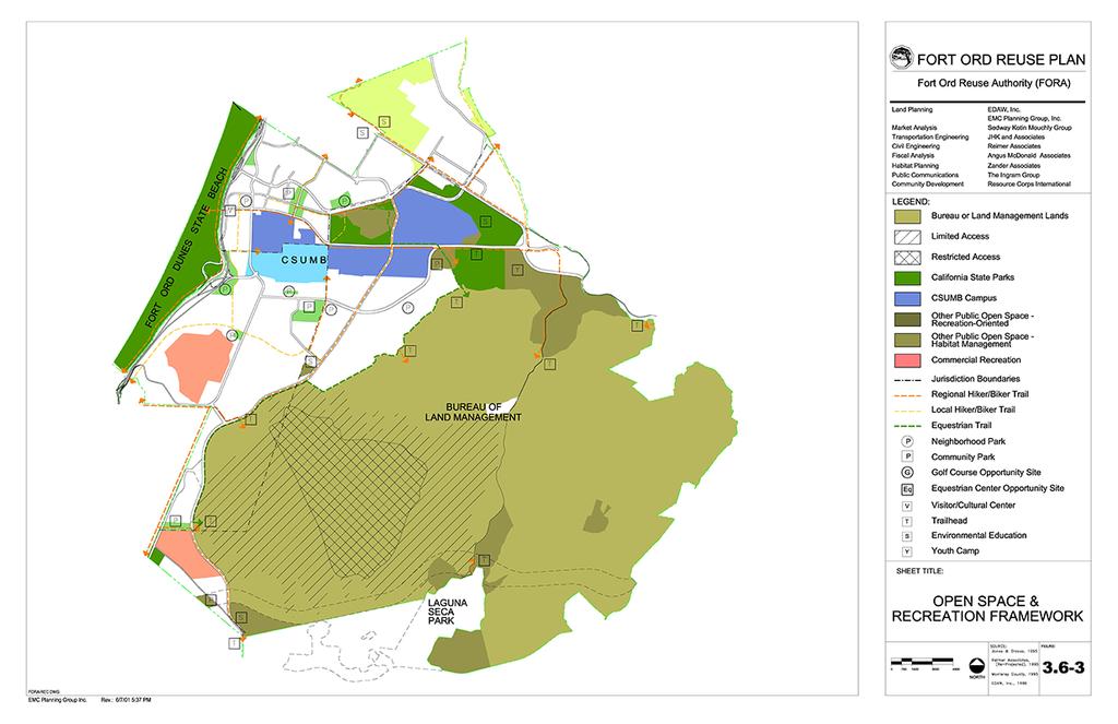
7 BRP Open Space & Recreation Framework

8 Relevant Trails Planning Efforts Todays Working Definition of Trails: Passage way or designated route for pedestrian, bicycle, equestrian, and/or other non-vehicular use. Includes paved, unpaved, urban, & rural routes. Requires entity maintenance & liability coverage. Land Use Jurisdictions City of Marina City of Seaside Monterey County (FORHA) City of Monterey City of Del Rey Oaks/MC Regional Parks Federal/State BLM CSUMB CA State Parks Cross-Jurisdictional Monterey Bay Sanctuary Scenic Trail Network (MBSSTN) Fort Ord Recreational Trail and Greenway (FORTAG) Peninsula Regional Planning
 Approved by")
 Incorporates entitled Fort Ord projects Includes design")
9 FORA LAND USE JURISDICTIONS City of Marina City of Marina Pedestrian & Bicycle Master Plan Circulation Recreation (Class 1) Approved by City Council, Feb 2, 2010 Amends General Plan Consistent with BRP (2010) Incorporates entitled Fort Ord projects Includes design guidelines
 Identifies bike routes throughout city Links to CSUMB and Coastal")
10 FORA LAND USE JURISDICTIONS City of Seaside Existing bikeways map in Seaside General Plan Update process underway Circulation Recreation BRP Consistent (2004) Identifies bike routes throughout city Links to CSUMB and Coastal Trail

11 FORA LAND USE JURISDICTIONS Monterey County Fort Ord Recreational Habitat Area Master Plan Trails network & habitat management planning Bellinger-Foster- Steinmetz Map Link

12 FORA LAND USE JURISDICTIONS City of Monterey Monterey on the Move Multi-modal Transportation Plan Circulation Recreation Adopted by City Council 3/19/13 Bike / Pedestrian focus

13 FORA LAND USE JURISDICTIONS City of Del Rey Oaks /MC Regional Parks Preliminary Frog Pond concept work in Del Rey Oaks No further action to date Future collaboration & planning with City

14 FEDERAL Bureau of Land Management (BLM) Link to maps 40 miles of administrative roads Fire break Vegetation management 46 miles of recreational trail Multi-use Segregated uses Current issues: signage, trail head quality, & maintenance

15 STATE California State Parks Tentative trail routes on Fort Ord Dunes State Park Final routing subject to change Timeline: 2-5yrs Funding & permit dependent

16 STATE CSU Monterey Bay Master Plan CSUMB Master Plan Pedestrian / bicycle focus Preliminary trail concept under development Connecting students to: Fort Ord Dunes State Park East Campus Housing National Monument

17 STATE/CROSS-JURISDICTIONAL CSU Monterey Bay: Trip Wise Regional bikeways Routing through CSUMB, Marina & Seaside Update pending late- 2014/ early-2015
 2011 Bike & Pedestrian Master")
18 Transportation Agency of Monterey County (TAMC) 2011 Bike & Pedestrian Master Plan


19 CROSS-JURISDICTIONAL Monterey Bay Sanctuary Scenic Trail Network Collaborative effort to construct a trail spanning the Monterey bay Began in 2000 at State Legislature TAMC Master Plan completed in 2008 Major State & regional trail linkage

20 CROSS-JURISDICTIONAL Preliminary Concept : Fort Ord Rec Trail & Greenway (FORTAG) Planning stages Phase 1: 9.6 Mile Northern Loop Costal Trail-East Garrison-Marina Phase 2: Southern Arm Coastal Trail Seaside- DRO Contacts: Fred Watson, CSUMB Scott Waltz, CSUMB Gail Morton, Marina

21 CROSS-JURISDICTIONAL Peninsula Regional trail connections Beginning focus - Carmel & Peninsula Carmel north to the Salinas River Planning / tourism oriented Victoria Beach, Carmel-by-the-Sea / CSUMB Faculty & student led
22 Coordination/Recommendations Coordination Meetings: CSUMB City of Marina City of Seaside Administrative Committee Post-Reassessment Advisory Committee Recommendations: Outreach to jurisdictions & stakeholders Regional Trails Symposium

23 Questions? Comments?
Design Fort Ord. welcome why we are here what happened this week design guidelines: ideas so far 2/12/2015. Regional Urban Design Guidelines (RUDG)
") Design Fort Ord Regional Urban Design Guidelines (RUDG) Welcome Back! Strategic Economics Alta Planning + Design National Charrette Institute Helix Environmental Planning Jeff Speck & Peter Katz Civitas
Design Fort Ord Regional Urban Design Guidelines (RUDG) Welcome Back! Strategic Economics Alta Planning + Design National Charrette Institute Helix Environmental Planning Jeff Speck & Peter Katz Civitas
Fort Ord Reuse Plan Attachment E to Item 7e FORA Board Meeting, 3/9/ Permitted Range of Land Uses for Fort Ord 226
 City of Seaside: In September 1991, the city submitted two separate requests to amend its SOI, with the goal of defining its Fort Ord SOI for general planning purposes. The proposed Seaside SOI boundaries
Regional Urban Design Guidelines
 Regional Urban Design Guidelines Interactive Website Online: http://www.designfortord.org Compliance Checklist FORT ORD REUSE AUTHORITY 6/10/2016 6/10/2016 Table of Contents Purpose... 3 How to Use This
INTRODUCTION. Strive to achieve excellence in all areas of operational sustainability.
 1 INTRODUCTION 1 INTRODUCTION A master plan guides the physical development of a campus, presenting long-range strategies for campus growth and transformation. As no single issue can be considered in isolation,
EXECUTIVE SUMMARY. Introduction
 EXECUTIVE SUMMARY Introduction State Route 68 is a designated scenic route that connects the world-renowned Monterey Peninsula to US Highway 101 and the Salinas Valley. SR 68 is a key route for bicycle,
FORT ORD MASTER PLAN GREATER MONTEREY PENINSULA AREA PLAN
 FORT ORD MASTER PLAN GREATER MONTEREY PENINSULA AREA PLAN DESCRIPTION The purpose of this plan is to designate land uses and incorporate objectives, programs, and policies to be consistent with the Fort
INTRODUCTION. 1.1 What is a General Plan? 1.2 Requirements for a General Plan. 1.3 Introduction to Monterey County
 1.1 What is a General Plan? INTRODUCTION California state law requires each city and county to adopt a comprehensive, long-term general plan for the physical development of the county or city, and any
Subject: 2014 Regional Transportation Plan Amendment No. 1
 Agenda Item: 6 Memorandum To: Board of Directors From: Grant Leonard, Transportation Planner Meeting Date: April 27, 2016 Subject: 2014 Regional Transportation Plan Amendment No. 1 RECOMMENDED ACTIONS
FORT ORD REUSE AUTHORITY
 FORT ORD REUSE AUTHORITY REGIONAL URBAN DESIGN GUIDELINES (RUDG) TASK FORCE MEETING 920 2 nd Avenue, Suite A, Marina CA 93933 (FORA Conference Room) 10:30 a.m., Wednesday, June 1, 2016 1. CALL TO ORDER
1.0 Circulation Element
 5/9/18 1.0 Circulation Element 1.1 Introduction As growth and development occur in Apache County, enhancements to its circulation system will be necessary. With time, more roads will be paved and air and
HILLSBOROUGH COUNTY Greenways and Trails Plan Update. Executive Summary. Date
 HILLSBOROUGH COUNTY Greenways and Trails Plan Update Executive Summary Date PURPOSE AND PROJECT OVERVIEW The Hillsborough County Greenways Master Plan (1995) and the City of Tampa s Greenways and Trails
Atlanta BeltLine Corridor Environmental Study. Scoping Meeting August 2008
 Atlanta BeltLine Corridor Environmental Study Scoping Meeting August 2008 What Will We Be Discussing Today? Study Overview - How Did We Get Here? - What Is the Study About? - Who Is Involved? - Where Is
REGIONAL TRANSPORTATION COMMISSION OF SOUTHERN NEVADA AGENDA ITEM
 REGIONAL TRANSPORTATION COMMISSION OF SOUTHERN NEVADA AGENDA ITEM Metropolitan Planning Organization [ X ] Transit [ ] Administration and Finance [ ] SUBJECT: PROJECT SELECTION PROCESS FOR TRANSPORTATION
Office of Greenways & Trails Providing Statewide Leadership and Coordination. Southeast Greenways and Trails Summit October 1-3, 2017
 Office of Greenways & Trails Providing Statewide Leadership and Coordination Southeast Greenways and Trails Summit October 1-3, 2017 1 Office of Greenways and Trails The Office of Greenways and Trails
Route 1 Corridor Study
 Route 1 Corridor Study Westbrook, Connecticut A Vision for the Connecticut Shoreline Public Informational Meeting July 28, 2015 Lower Connecticut River Valley Council of Governments Fitzgerald & Halliday,
CITY OF SEASIDE STAFF REPORT
 Item 12 CITY OF SEASIDE STAFF REPORT TO: FROM: BY: Honorable Mayor and City Council Ray Corpuz, City Manager Diana Ingersoll, Deputy City Manager, Resource Management Services Rick Medina, Senior Planner
RECREATION, OPEN SPACE AND GREENWAYS ELEMENT GOALS, OBJECTIVES, AND POLICIES
 RECREATION, OPEN SPACE AND GREENWAYS ELEMENT GOALS, OBJECTIVES, AND POLICIES GOAL R-1: DEVELOP A RECREATION, OPEN SPACE AND GREENWAYS SYSTEM AS AN INTEGRAL COMPONENT OF AN OVERALL, COUNTY-WIDE ECONOMIC
PLANNING CONTEXT. Figure 2.1: Regional Context «101 «183 « DRAFT June a n. f i c O c e CALIFORNIA STATE UNIVERSITY MONTEREY BAY.
 2 PLANNING CONTEXT 2 PLANNING CONTEXT California State University Monterey Bay is one of twenty-three campuses in the California State University (CSU) System. In the fall of 2015, CSUMB had an enrollment
11.0 TRANSPORTATION ELEMENT
 11.0 TRANSPORTATION ELEMENT Transit, Circulation and Parking Sub-Element: For all campuses, FIU's goal is to increase multimodal access. In combination with other measures - such as the development of
Rich Valley Greenway Master Plan. Central Greenway Connectivity Study
 Rich Valley Greenway Master Plan Central Greenway Connectivity Study Dakota County Planning Commission February, 2017 Rich Valley Greenway Master Plan Dakota County Greenway Vision Establish a County-wide
CAMPUS PLACEMAKING: CAC WORK SESSION. August 23, 2018
 CAMPUS PLACEMAKING: CAC WORK SESSION August 23, 2018 AGENDA Public Realm Framework Overview & Discussion (~20 minutes) Health & Wellness Report Overview & Discussion (~15 minutes) Riverfront Update & Discussion
Por favor, levanten la mano si necesita traduccion en espanol Please raise your hand if you need Spanish translation
 FEDERAL BOULEVARD CORRIDOR WIDE STUDY PUBLIC MEETING #1 APRIL 27, 2016 Por favor, levanten la mano si necesita traduccion en espanol Please raise your hand if you need Spanish translation HDR DESIGN WORKSHOP
December 31, 2005 CITY OF MARINA GENERAL PLAN
 December 31, 2005 CITY OF MARINA GENERAL PLAN City Of Marina 2000 General Plan ADOPTED OCTOBER 31, 2000 AMENDED THROUGH December 2005 Preface This document comprises the 2000 Marina General Plan as amended
California State University, Monterey Bay Campus Parking Relocation Project Attachment to Notice of Exemption
 California State University, Monterey Bay Campus Parking Relocation Project Attachment to Notice of Exemption California State University, Monterey Bay (CSUMB) proposes to improve an existing oncampus
SH 199 Corridor Master Plan. Community Meeting No. 2 May 31, 2017
 Community Meeting No. 2 May 31, 2017 Transportation Projects On or Near SH 199 SH 199 from 0.3 miles south of FM 1886 to south end of Lake Worth bridge Construct freeway mainlanes and frontage roads 10-Year
Concord Hills Regional Park Land Use Plan
 Photo by Stephen Joseph Public Meeting #2: Design Concepts Review November 19, 2015 Agenda Photo by Stephen Joseph 1) Welcome 2) Presentation Project Background and Status Existing Conditions, Opportunities,
NORTH CLAYMONT AREA MASTER PLAN COMMUNITY WORKSHOP #1 FEBRUARY 3, 2016
 NORTH CLAYMONT AREA MASTER PLAN COMMUNITY WORKSHOP #1 FEBRUARY 3, 2016 1. Introduction To the team and to the Plan Planning Partners The Claymont Community WILMAPCO New Castle County Claymont Renaissance
NOTICE OF PREPARATION
 NOTICE OF PREPARATION DATE: September 19, 2012 TO: All Recipients on the Attached Distribution List LEAD AGENCY: City of Seaside Resource Management Services Department CONTACT: SUBJECT: PROJECT TITLE:
3. VISION AND GOALS. Vision Statement. Goals, Objectives and Policies
 Vision Statement Queen Creek s interconnected network of parks, trails, open spaces and recreation opportunities provide safe and diverse activities and programs that sustain its unique, small town, equestrian
Plan Overview. Manhattan Area 2035 Reflections and Progress. Chapter 1: Introduction. Background
 Plan Overview The Manhattan Urban Area Comprehensive Plan (the Comprehensive Plan) is a joint planning initiative of the City of Manhattan, Pottawatomie County, and Riley County. The 2014 Comprehensive
City of Hermosa Beach Administrative Policy #
 City of Hermosa Beach Administrative Policy # SUBJECT: Living Streets Policy Date: Approved by: City Council Authority: Public Works Department & Community Development Department Mayor, PURPOSE The City
Draft Stillwater 2030 Comprehensive Plan- Goals and Policies
 Draft Stillwater 2030 Comprehensive Plan- Goals and Policies Instructions- Review each goal and policy and discuss with group any changes, deletions for additions to the list using your groups pen. Keep
Introduction. Chapter 1. Purpose of the Comprehensive Plan Plan Organization Planning Process & Community Input 1-1
 Chapter 1 Introduction Lakewood 2025: Moving Forward Together Purpose of the Comprehensive Plan Plan Organization Planning Process & Community Input 1-1 Purpose of the Comprehensive Plan The Comprehensive
Chapter 5: Recreation
 Chapter 5: Recreation Introduction and Setting Recreational opportunities within Nevada County are varied, ranging from public parks with intensively used active recreational facilities, to vast tracts
CAL POLY MASTER PLAN UPDATE, March 2015
 Some Key Themes in the General Guiding Principles Academic Mission The plan must foremost advance the University s academic mission and student success. Foresight and Adaptability The plan should take
Section 4: Goals, Objectives, and Strategies
 99 Section 4: Goals, Objectives, and Strategies Goal 1 Resource Protection, Maintenance, Preservation, and Enhancement Protect, preserve, maintain, and enhance the natural, recreational, archaeological,
TEMPLE MEDICAL & EDUCATION DISTRICT
 City of Temple, Texas TEMPLE MEDICAL & EDUCATION DISTRICT 1 Description. The City of Temple joined in partnership with key public and private entities to jointly promote education and medical activities
PLAN ELEMENTS WORKSHOP. April 5, 2016
 PLAN ELEMENTS WORKSHOP April 5, 2016 needs more housing. But there is no one-size fits-all solution. Every neighborhood has its own character. In some places, density is not only appropriate it is badly
CHAPTER 1. Ms. Guajardo s Class - Central Elementary CH 1 1
 INTRODUCTION CHAPTER 1 Ms. Guajardo s Class - Central Elementary CH 1 1 1.1 SETTING South Centre City is a linear corridor south of Downtown Escondido paralleling Centre City Parkway and South Escondido
Yadkin River Greenway Feasibility Study Fact Sheet Village of Clemmons, Town of Lewisville, Town of Bermuda Run
 Fact Sheet Village of Clemmons, Town of Lewisville, Town of Bermuda Run Project Background The Yadkin River Greenway Feasibility Study is a joint project with the Village of Clemmons, the Town of Bermuda
DOMINION BOULEVARD CORRIDOR STUDY AND ECONOMIC DEVELOPMENT STRATEGIC PLAN A MODEL FOR CHESAPEAKE S FUTURE
 DOMINION BOULEVARD CORRIDOR STUDY AND ECONOMIC DEVELOPMENT STRATEGIC PLAN A MODEL FOR CHESAPEAKE S FUTURE Overview I. Draft Plan Process II. Draft Plan Overview a. Market Analysis b. Master Land Use Plan
BURTON STATION STRATEGIC GROWTH AREA PLAN UPDATE PUBLIC MEETING 3/26/18
 BURTON STATION STRATEGIC GROWTH AREA PLAN UPDATE PUBLIC MEETING 3/26/18 1 WHERE WE ARE? 2 PRIMARY OBJECTIVES OF THE PLAN UPDATE 1. Update the land use designation for Burton Station Village to reflect
Concept Master Plan. for. Draft of. Wildlife Management Area. Prepared for. June, 2008
 Draft of Concept Master Plan for Vermillion Highlands: A Research, Recreation and Wildlife Management Area Prepared for Vermillion Highlands Steering Committee - Minnesota Department of Natural Resources
TRANSPORTATION ELEMENT GOALS, OBJECTIVES, AND POLICIES
 TRANSPORTATION ELEMENT GOALS, OBJECTIVES, AND POLICIES GOAL 2 The City shall provide a safe, convenient, effective, and energy efficient multimodal transportation system which is coordinated with the Future
Presentation of the Staff Draft. July 17, 2014 SSRVP Team, Area 3
 Presentation of the Staff Draft July 17, 2014 SSRVP Team, Area 3 Presentation Overview Introduction Plan Framework Plan Recommendations Implementation Next Steps and Request for Public Hearing on September
Laberge Group. Town of Coeymans. Draft Comprehensive Plan. Overview of Planning Process
 Draft : Presentation of Goals & Strategies Laberge Group Benjamin H. Syden, A.I.C.P., E.D.P Director in Charge Nicole Allen, A.I.C.P. Senior Planner Anjali Malhotra Planner Presentation Outline Introductions
Iowa 100 Extension Project Visualizations for Design and Public Involvement ASCE Transportation Conference November 6, 2013 Ames, Iowa
 Iowa 100 Extension Project Visualizations for Design and Public Involvement 2013 ASCE Transportation Conference November 6, 2013 Ames, Iowa Agenda Project Corridor Constraints Key Features Project History
The transportation system in a community is an
 7 TRANSPORTATION The transportation system in a community is an important factor contributing to the quality of life of the residents. Without a sound transportation system to bring both goods and patrons
Scope of Services. River Oaks Boulevard (SH 183) Corridor Master Plan
 Corridor Master Plan") Scope of Services River Oaks Boulevard (SH 183) Corridor Master Plan PROJECT AREA The project area consists of the River Oaks Boulevard (SH 183) corridor bounded by SH 199 at the northern end and the Trinity
Scope of Services River Oaks Boulevard (SH 183) Corridor Master Plan PROJECT AREA The project area consists of the River Oaks Boulevard (SH 183) corridor bounded by SH 199 at the northern end and the Trinity
Good Neighbor Plan Dallas Love Field Airport Transportation and Environment Committee
 June 25, 2012 Good Neighbor Plan Dallas Love Field Airport Transportation and Environment Committee Overview Vision for Dallas Love Field Downtown Dallas 360 Plan Targeted Improvement Zones Lemmon Avenue
City of Missoula and Missoula County Open Space Planning Open House
 City of Missoula and Missoula County Open Space Planning Open House FEBRUARY 6, 2018 The following slides contain the display board content from the open house. Please use boards to answer questions in
OPEN SPACE FRAMEWORK CONNECT AND ENHANCE CAMPUS OPEN SPACE
 OPEN SPACE FRAMEWORK CONNECT AND ENHANCE CAMPUS OPEN SPACE INTRODUCTION The university continues to value its connection to the natural environment, and accordingly, the master plan s open space framework
The Village of Sugar Grove, in partnership with Kane County, the Illinois Department of Transportation, and the Illinois Tollway welcomes you to the
 The Village of Sugar Grove, in partnership with Kane County, the Illinois Department of Transportation, and the Illinois Tollway welcomes you to the first Public Meeting for the proposed interchange improvement
UNCW CAMPUS MASTER PLAN
 UNCW CAMPUS MASTER PLAN JULY 27, 2017 MASTER PLAN FRAMEWORK RECOMMENDATIONS BOARD OF TRUSTEES PRESENTATION UNCW Campus Master Plan Update Board of Trustees Presentation July 27, 2017 The attached Campus
Introduction...UD-1. Plan...UD-3
 URBAN DESIGN ELEMENT TABLE OF CONTENTS Section Page Introduction...UD-1 Purpose of the Urban Design Element...UD-1 Scope and Content of the Urban Design Element...UD-1 Related Plans and Programs...UD-1
Ten Mile Creek Planning Area
 PLANNING AREA POLICIES TEN MILE CREEK Ten Mile Creek Planning Area Location and Context The Ten Mile Creek Planning Area ( Ten Mile Creek area ) is located south of the current Boise AOCI, generally south
University of Saskatchewan CAMPUS MASTER PLAN. Senate Meeting Preliminary Presentation. April 21, 2018 DIALOG ECS DA WATT
 University of Saskatchewan CAMPUS MASTER PLAN Senate Meeting Preliminary Presentation April 21, 2018 DIALOG ECS DA WATT project process presentation agenda Stakeholder Engagement Project Control phase1
RECREATION AND OPEN SPACE ELEMENT
 RECREATION AND OPEN SPACE ELEMENT Last amended August 19, 2008 Table of Contents Objective Page 5.1 Park system defined... 5-1 5.2 Access to parks and recreational facilities... 5-2 5.3 Recreation and
Public input has been an important part of the plan development process.
 Lakewood s Comprehensive Plan recognizes that transportation helps shape the community, and that the way the community provides for the safe and efficient movement of people affects the character of the
Introduction 1. Contents. Draft:
 Draft: 1-9-2012 1 Contents 1.1 The Plan Area 1.1.1 Location 1.1.2 History 1.2 The Specific Plan 1.2.1 Specific Plan Process 1.2.2 Purpose and Intent 1.2.3 Goals and Vision 1.2.4 Planning Districts 1.2.5
Atlanta BeltLine, Inc. Pathways to Urban Sustainability
 Atlanta BeltLine, Inc. Pathways to Urban Sustainability September 30, 2010 WHAT IS THE ATLANTA BELTLINE? Transit 22-mile loop Parks 1300 + new acres Trails 33 miles Jobs & Economic Development 20 areas,
EL DORADO COUNTY GENERAL PLAN PARKS AND RECREATION ELEMENT PRINCIPLE INTRODUCTION STATE AUTHORIZATION
 EL DORADO COUNTY GENERAL PLAN PARKS AND RECREATION ELEMENT PRINCIPLE The General Plan must identify the types of governmental services, including parks and recreation facilities, which are necessary to
Venice Pumping Plant Dual Force Main Project Draft EIR
 City of Los Angeles 5.9 LAND USE PLANS 5.9.1 Environmental Setting Venice Pumping Plant Dual Force Main Project Draft EIR The Project lies within the bounds of Los Angeles County and the City of Los Angeles.
Potential Green Infrastructure Strategies May 6, 2015 Workshop
 Potential Green Infrastructure Strategies May 6, 2015 Workshop Background The City of Cortland is developing the Tioughnioga Urban Headwaters Green Infrastructure Action Plan with funding from the National
S C O P E O F W O R K A P R I L
 white flint 2 sector plan S C O P E O F W O R K A P R I L 2 0 1 2 MONTGOMERY COUNTY PLANNING DEPARTMENT M-NCPPC MontgomeryPlanning.org 1 white flint 2 sector plan Scope of Work abstract This scope of work
Speedway Mall Project Frequently Asked Questions
 Speedway Mall Project Frequently Asked Questions These FAQs will continue to be updated as new questions arise. Purpose of the Project and Uses of the Mall Q: Why is this project being done? A: The 1999
Executive Summary. NY 7 / NY 2 Corridor
 Executive Summary NY 7 / NY 2 Corridor Transportation and Land Use Study December 2005 Prepared for: Town of Colonie Capital District Transportation Committee Prepared by: Introduction: Land use decisions
CHARLES PUTMAN CHARLES PUTMAN AND ASSOCIATES, INC
 MEMORANDUM CHARLES PUTMAN & ASSOCIATES, INC. LAND DEVELOPMENT CONSULTANTS PLANNING ZONING PERMITTING 4722 NW Boca Raton Boulevard, Suite C-106 Boca Raton, Florida 33431 Phone: 561/994-6411 FAX: 561/994-0447
Open House - Programing and Planning Social Sciences Facility & Classroom Auditorium. Capital Planning Process
 Open House - Programing and Planning Social Sciences Facility & November 3, 2011 Recreation Lounge Colleges Nine and Ten Capital Planning Process 2005 Long Range Development Plan 2010 Physical Design Framework
FORT ORD BALLOT INITIATIVES. MPC Governing Board Meeting September 25, 2013
 FORT ORD BALLOT INITIATIVES MPC Governing Board Meeting September 25, 2013 2 initiatives on the November 5 Ballot Why do these initiatives have significance for MPC? Both address land use in the Parker
Table L-1 Summary Action Strategy. Action Item Timing Status Responsible Agency
 CHAPTER 4: CIRCULATION ELEMENT ISSUE #1: MAJOR THOROUFARES AND TRANSPORTATION ROUTES A balanced transportation system for Fontana is provided that meets the mobility needs of current and future residents
U T D N o r t h C a m p u s T O D and D o w n t o w n D e n t o n T O D
 U n i v e r s i t y o f T e x a s a t D a l l a s C i t y o f R i c h a r d s o n U T D N o r t h C a m p u s T O D and D o w n t o w n D e n t o n T O D Rick Leisner, AICP Assistant Director of Development
TOWN OF BETHLEHEM MEETING SUMMARY LOCAL WATERFRONT REVITALIZATION PROGRAM UPDATE
 TOWN OF BETHLEHEM LOCAL WATERFRONT REVITALIZATION PROGRAM UPDATE MEETING SUMMARY Purpose: LWRP Update Public Workshop #3 Date and Time: October 24, 2017, 6:00 pm - 8:00 pm Location: Town Hall, 445 Delaware
CITY OF SIMI VALLEY MEMORANDUM
 CITY OF SIMI VALLEY MEMORANDUM AGENDA ITEM NO. Consent (3) August 15, 2016 TO: FROM: City Council Department of Public Works SUBJECT: ADOPTION OF PLANS AND SPECIFICATIONS AND AUTHORIZATION TO SOLICIT CONSTRUCTION
ORDINANCE NO WHEREAS, the recommendations from the Pinellas County Local Planning Agency have been received and considered.
 ORDINANCE NO. 16-55 AN ORDINANCE OF THE COUNTY OF PINELLAS, AMENDING THE FUTURE LAND USE AND QUALITY COMMUNITIES ELEMENT OF THE PINELLAS COUNTY COMPREHENSIVE PLAN TO ADOPT THE CRYSTAL BEACH COMMUNITY OVERLAY;
Great Rivers Greenway CLEAN GREEN CONNEC TED T RAILS
 Great Rivers CLEAN GREEN CONNEC TED T RAILS Great Rivers (GRG) was established in 2000 to create a clean, green, connected St. Louis region. Today, many new and exciting projects demonstrate the social,
1.0 INTRODUCTION 1.1 TH 14 WEST STUDY AREA Project Description Functional Classification Purpose of the Project
 1.0 INTRODUCTION 1.1 TH 14 WEST STUDY AREA 1.1.1 Project Description The Trunk Highway (TH) 14 West Corridor is a two-lane roadway approximately 22 miles in length. Located in Nicollet County, the corridor
CITY OF CHARLOTTESVILLE, VIRGINIA CITY COUNCIL AGENDA
 CITY OF CHARLOTTESVILLE, VIRGINIA CITY COUNCIL AGENDA Agenda Date: December 16, 2013 Action Required: Adoption of Resolution Presenter: Staff Contacts: Title: James E. Tolbert, AICP, Director of NDS James
The Vision. Photo provided by The Minervini Group. 46 Vision, Objectives & Strategies
 Vision, Objectives & Strategies The is the public framework and guide for future development of the Grand Traverse Commons. The establishes public polices for infrastructure, the preservation of natural
Capital Projects in and near Odenton Town Center
 Capital Projects in and near Odenton Town Center Map ID Anne Arundel County Department of Public Works This project provides for the design, right of way acquisition, and construction of approximately
Port of San Diego Sea Level Rise Ad Hoc Committee Meeting 1 of 3.. September 18, 2018
 Port of San Diego Sea Level Rise Ad Hoc Committee Meeting 1 of 3. September 18, 2018 Agenda Welcome Introductions Rules of the Ad-Hoc Presentation Background Vulnerability Assessment Results Non-Agenda
process of the Land Development Code to assure regional parks are available County-wide.
 GOAL 9.0. It is the goal of the Broward County Board of County Commissioners to provide safe and adequate recreation sites and facilities, including cultural art facilities, and open space to satisfy the
Grand Rounds History
 Grand Rounds History 1883 Plan for Minneapolis Park System prepared by Landscape Architect Horace W. S. Cleveland. The system of connecting parks and parkways was first called the Grand Rounds by William
FOSTER COMPREHENSIVE PLAN UPDATE CIRCULATION
 5.8.1 INTRODUCTION CIRCULATION The Circulation Element of the Comprehensive Plan studies the routes and modes of travel. The circulation network of the town affects the ease of movement through Foster
REGIONAL ACTIVITY CENTER
 DRAFT REGIONAL ACTIVITY CENTER 70 EAST BENCH MASTER PLAN DRAFT 06 Introduction The East Bench Regional Activity center is comprised of large educational, research, medical, and employment centers. These
Dyersville Downtown Plan. Open House October 24, 2017
 Dyersville Downtown Plan Open House October 24, 2017 What is a Comprehensive Plan? - Vision - Guidance for decisions - Basis for regulations What is a Downtown Plan? - Understand priorities - Identify
3.0 PROJECT DESCRIPTION
 East Garrison Specific Plan - Draft Subsequent EIR Project Description 3.0 PROJECT DESCRIPTION 3.1 PROJECT LOCATION AND SETTING The East Garrison Specific Plan (EGSP) project site is located within unincorporated
2030 Comprehensive Plan VISION STATEMENT
 RESOURCE DOCUMENT for Steering Committee Meeting #2 July 12, 2017 2030 Comprehensive Plan VISION STATEMENT Steering Committee from 2008 Established the Lauderdale s Vision as: Creating a livable, lovable
This page left intentionally blank.
 July 2012 This page left intentionally blank. Table of Contents Appendix A : Project Development Checklist Appendix B: At-Grade Rail Crossings Appendix C: Maintenance and Operations Examples Appendix D:
OPEN SPACE TYPES. SIZE 8 acres. SIZE 20 acres. SIZE 1 acre
 TYPICAL CHARACTERISTICS OPEN SPACE TYPES OPEN SPACE TYPES The neighborhood contains an extensive variety of open space types. Most of these spaces incorporate multiple uses and activities, so that each
Resolution# THIS RESOLUTION is adopted with reference to the following facts and circumstances:
 Resolution# 02-3 Resolution Certifying that the ) Amendments to the General Plan of ) the County of Monterey are Consistent) with the Fort Ord Base Reuse Plan. ) THIS RESOLUTION is adopted with reference
India Basin/Hunters Point Shoreline Community Workshop May 21, 2008
 India Basin/Hunters Point Shoreline Community Workshop May 21, 2008 Workshop Agenda Welcome Process Overview Context & Existing Conditions Presentation of Draft Concepts Land Use and Open Space Priorities
1 Welcome! UBC Okanagan Master Plan Update - Open House
 1 Welcome! UBC Okanagan Master Plan Update - Open House UBC is updating the Master Plan for the Okanagan Campus. The purpose of today s Open House is to: Present the draft 2015 Master Plan Answer any questions
Whitemarsh Comprehensive Plan Update: Housing & Land Use. Public Workshop #3: September 20, 2018
 Whitemarsh Comprehensive Plan Update: Housing & Land Use Public Workshop #3: September 20, 2018 Agenda Welcome Process Recap What We ve Heard The Plan Framework Review of Recommended Actions Land Use Housing
UO North Campus Conditional Use Permit Project
 UO North Campus Conditional Use Permit Project Project Overview and Background November 2017 Campus Planning, CPFM Project Boundary Previous Conditional Use Permit: 1988 to 2012 Site History Statement
M E M O R A N D U M. DATE: July 19, Patrick D. O Keeffe, City Manager. Economic Development & Housing
 M E M O R A N D U M DATE: July 19, 2011 TO: FROM: Patrick D. O Keeffe, City Manager Economic Development & Housing SUBJECT: Resolution of the City Council of the City of Emeryville Approving the Application
Phase 1 : Understanding the Campus Context. Phase 2 : APPROACHES - Alternates & Preferred Plan
 Introduction MASTER PLAN PURPOSE WHY A CAMPUS MASTER PLAN? The purpose of the Master Plan at the University of Illinois at Chicago is to translate UIC s strategic goals and objectives into a compelling
SPECIFIC PLAN Requirements
 CITY OF LANCASTER PLANNING DEPARTMENT 44933 Fern Avenue, Lancaster, California 93534 (661) 723-6100 SPECIFIC PLAN Requirements Purpose The purpose of a specific plan is to provide for the logical development
A larger version of this map is located on the last page of this PDF.
 MAP Committee Input McLoughlin Area Draft Vision Map A larger version of this map is located on the last page of this PDF. 1. The map above is intended to portray a vision for the McLoughlin area. It highlights
Isabel Neighborhood Plan: Alternatives
 Isabel Neighborhood Plan: Alternatives Presented by: Lori Parks, Associate Planner February 2, 2015 Agenda 1. Background on BART to Livermore 2. Isabel Neighborhood Plan 3. Alternative Scenarios 4. General