Subareas 9 & 10 Master Plan Updates
|
|
|
- Warren James
- 5 years ago
- Views:
Transcription

1 Atlanta BeltLine Subareas 9 & 10 Master Plan Updates Study Group Meeting 4 September 17, 2018 Washington Park Jamboree 1


2 22 miles, connecting 45 neighborhoods 22 MILES of transit 46 MILES of streetscapes and complete streets 33 MILES of urban trails 1,300 ACRES of new greenspace 700 ACRES of renovated greenspace 1,100 ACRES of environmental clean-up $10-20B in economic development 30,000 permanent jobs 48,000 construction jobs 28,000 new housing units 5,600 affordable units CORRIDOR- WIDE public art, historic preservation, and arboretum


3 Atlanta BeltLine Vision & Mission To be the catalyst for making Atlanta a global beacon for equitable, inclusive, and sustainable city life. We are delivering transformative public infrastructure that enhances mobility, fosters culture, and improves connections to opportunity. We are building a more socially and economically resilient Atlanta with our partner organizations and host communities through job creation, inclusive transportation systems, affordable housing, and public spaces for all. 3

4 Meeting Agenda Subarea Master Plan Update Purpose and Schedule Master Plan Update Process What We ve Heard Demographics and Market Overview Land Use and Mobility Recommendations Let Us Know What You Think Action Plan / Work Program 4

5 Subarea Master Plan Purpose Goal Implement the Redevelopment Plan goals in the context of each unique geographic area Purpose To guide growth for vibrant, livable mixed-use communities by applying best management practices for transit oriented development, mobility, green space, and alternative modes of transportation.
6 Subarea Master Plan Update Purpose The original 10 Subarea Master Plans completed ~10 years ago Subarea 9 Master Plan adopted in 2009 Subarea 10 Master Plan adopted in 2010 A lot has happened it s time to update the plans to reflect these changes and the potential for future success These are updates, so they will not be as long or as detailed as the previous plans We are not starting from scratch 6

7 NEIGHBORHOODS Subarea 9 & 10 Context Bankhead Grove Park Rockdale Ashview Heights Bankhead English Avenue Harris Chiles Just Us Vine City SUBAREA 9 English Avenue Knight Park / Howell Station SUBAREA 10 Atlanta University Center Grove Park Hunter Hills Mozley Park West End Subarea 9 Subarea 10


8 Subarea 9 & 10 Master Plan Team 8
9 Study Group Meeting 1: Kick-off Meeting, March 26 th Subarea 9 & 10 Master Plan Update Schedule Study Group Meeting 2: Workshop Saturday, April 28 th, 10:00 A.M. 12:00 P.M. (Subarea 9) Saturday, April 28 th, 1:00 P.M. 3:00 P.M. (Subarea 10) Study Group Meeting 3: Draft Recommendations August 27 th, 6:30 P.M. to 8:00 P.M. Study Group Meeting 4: Draft Action Plan (You are here) Study Group Meeting 5: Final Work Plan/ Recommendations TBD Plan Adoption: 4th Quarter

10 Subarea Master Plan Update Process 10
11 Implementing the Plan Goals and Guiding Principals Future Land Use Map Bike/Pedestrian Circulation Plan Vehicular Circulation Plan Street Framework Plan Action Plan / Work Program 11
12 SUBAREA 9

13 Subarea 9 Context
14 What We ve Heard Strengths and Opportunities Sense of community, lots of history and culture Lovely place to live close to the city Legacy residents Westside Reservoir Park 14
15 What We ve Heard Weaknesses and Threats Lack of retail and grocery store options Lack of entertainment options for younger couples and families Reduction in the number of owner-occupied homes investors buying real estate Lack of access and connectivity to surrounding amenities and across railroad tracks Lack of good bike and sidewalk network with safe pedestrian crossings and lighting 15
16 What We ve Heard Consolidated Comments Enhance the bike/sidewalk network - Provide safe and direct bike and pedestrian access from surrounding neighborhoods to Westside Reservoir Park, Bankhead MARTA Station, Proctor Creek Greenway and existing and future activity nodes Advance streetscape improvements Advance improvements to area parks Provide opportunities for hiking/mountain biking in Westside Park 16
17 Plans present Vine City/Washington Park LCI 2009 Atlanta Region Plan Tier 1 Final Environmental Impact Statement 2012 Atlanta Beltline 2030 Strategic Implementation Plan 2013 Westside TAD Neighborhoods Strategic Implementation Plan 2013 Mixed Income TOD Implementation Strategy 2013 Transit-Oriented Development Implementation Strategy Assistance 2013 Washington Park Neighborhood Visioning Plan 2015 Atlanta Beltline, Inc. Westside Impact Neighborhood Analysis 2015 Atlanta Streetcar Systems Plan 2015 City of Atlanta Capital Improvements Program & Community Work Program 2015 Integrated Action Plan: Economic Development, Housing, & Real Estate 2015 Proctor Creek Greenway Trail Master Plan & Implementation Strategy 2016 Proctor Creek Watershed Improvement Plan 2016 Vine City/Washington Park LCI Update 2017 Westside Land Use Framework Plan 2017 Atlanta City Design 2017 D3 Westside Revive 2018 Art on the Atlanta BeltLine 2018
18 Major Changes Since 2009 Proctor Creek Greenway Phase I trail completed BeltLine trail construction to Washington Park completed Westside Reservoir Park Phase I underway Donald Lee Hollowell streetscape project underway Atlanta Streetcar System proposed line extension to Bankhead Significant redevelopment proposed in the immediate vicinity 18
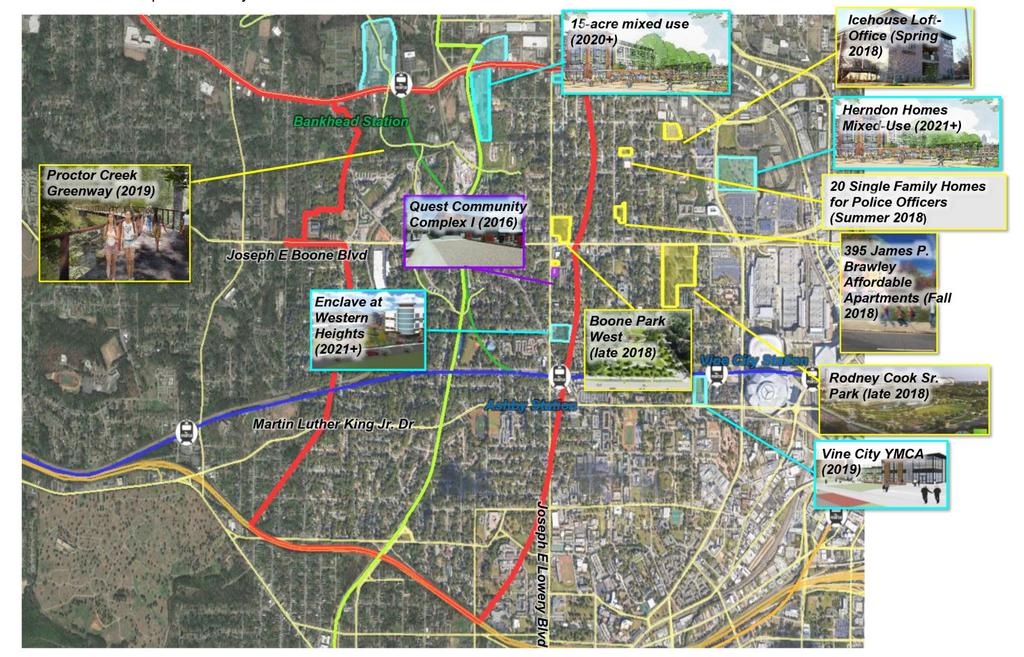
19 Development Activity in Subarea 9

20 Subarea 9: Market Analysis Significant Demand for: Rental Apartments Office Growing Demand for: Infill Townhomes Neighborhood Retail / Restaurant / Services Major Catalytic Sites: Urban Creek Partners Wood Partners Proposed West Marietta Street Development Future Redevelopment Mead Westvaco Site *Note: Demand is based on the existing and projected number of residential units Subarea 3
21 Subarea 9: Draft Future Land Use Plan 1. Increase existing park space to be consistent with future Westside Reservoir Park boundary 2. Increase density (MU 10+ stories and MF 5-9 stories) around the Bankhead MARTA station 3. Convert a portion of industrial properties along J.E. Lowery to mixed-industrial while retaining a portion of existing industrial 4. Convert vacant land east of Lois St. to mediumdensity mixed-use (MU 5-9 stories) 5. Convert a portion of Marietta Blvd. from industrial to low density mixed-use (MU 1-4 stories) 6. Provide medium-density multi-family (MF 5-9 stories) south of W. Marietta St. (SE corner) and south of Jefferson St. 7. Provide medium-density mixed-use (MU 5-9 stories) south of Jefferson St. and north of D.L. Hollowell Parkway
22 Subarea 9: Changes to Land Use Plan - Post Community Meeting #3 2. Increase density (MU 10+ stories and MF 5-9 stories) around the Bankhead MARTA station Originally MU 10+ stories and MU 5-9 stories 3. Convert a portion of industrial properties along J.E. Lowery to mixed-industrial while retaining a portion of existing industrial Originally a greater number of parcels were designated as mixedindustrial 5. Convert a portion of Marietta Blvd. from industrial to low density mixed-use (MU 1-4 stories) Originally low-density commercial

23 Subarea 9: Draft Circulation (Bike/Ped) Plan 1. Add sidewalks on major corridors that do not have sidewalks or have intermittent sidewalks 2. Add ADA ramps to non-compliant intersections with sidewalks 3. Evaluate adding multi-use trail west from Jefferson St./Marietta Blvd. over CSX tracks to provide access to the Proctor Creek Trail 4. Continue bike lane on D.L. Hollowell Pkwy to West Lake Ave. 5. Evaluate multi-use trail under D.L. Hollowell Pkwy. through culvert along Proctor Creek to provide access to Proctor Creek Trail and Bankhead MARTA Station 6. Provide streetscape on W. Marietta St. from Marietta Blvd. to Brady Ave./8 th St.
24 Subarea 9: Draft Circulation (Vehicular) Plan 1. Evaluate Street Retrofit: J.E. Lowery Blvd. Convert 3 lanes to 2 lanes with 5 ft. wide bike lanes 2. Streetscape improvements: Lois Rd., Johnson Rd. and Perry Blvd. 3. Street Retrofit: Marietta Blvd. Evaluate a road diet and potential for near-term cycle track/future BeltLine transit 4. BeltLine and D.L. Hollowell Pkwy to North Ave. corridor streetcar/lrt 5. Various intersection improvements consistent with the original SA master plan
25 Subarea 9: 1. Enhance the street network 2. Add connection to Westside Reservoir Park from Knight Park/Howell Station at SW apex of Niles Avenue Draft Street Framework Plan 3. Provide multi-modal operational, access and safety improvements to accommodate future development
26 Subarea 9: Cross Sections: Option A - J.E. Lowery Boulevard


27 Subarea 9: Cross Sections: Option B - J.E. Lowery Boulevard


28 Subarea 9: Cross Sections: Marietta Blvd.
29 SUBAREA 10

30 Subarea 10 Context
31 What We ve Heard Strengths and Opportunities Culturally rich history and proud residents Strong sense of community, lots of community gatherings Affordable housing Transit access Recently opened BeltLine Westside Trail 31
32 What We ve Heard Weaknesses and Threats Lack of a food and other retail options Abandoned and dilapidated buildings Lack of affordable senior housing options Renters at risk Flooding/Stormwater infrastructure Lack of safe bike and pedestrian infrastructure Limited job opportunities 32
33 What We ve Heard Consolidated Comments Enhance retail and entertainment options Advance improvements to Maddox park Advance streetscape improvements Connect North Avenue south of Maddox Park 33
34 What We ve Heard Consolidated Comments Enhance the bike/sidewalk network - Provide safe bike and pedestrian access to Westside Reservoir Park, Bankhead MARTA Station, Proctor Creek Greenway and existing and future activity nodes Cycling is not a viable transportation option for everyone do not reduce capacity to provide bike lanes that benefit just a few people 34
35 Plans present Vine City/Washington Park LCI 2009 Atlanta Region Plan Tier 1 Final Environmental Impact Statement 2012 Atlanta Beltline 2030 Strategic Implementation Plan 2013 Westside TAD Neighborhoods Strategic Implementation Plan 2013 Mixed Income TOD Implementation Strategy 2013 Transit-Oriented Development Implementation Strategy Assistance 2013 Washington Park Neighborhood Visioning Plan 2015 Atlanta Beltline, Inc. Westside Impact Neighborhood Analysis 2015 Atlanta Streetcar Systems Plan 2015 City of Atlanta Capital Improvements Program & Community Work Program 2015 Integrated Action Plan: Economic Development, Housing, & Real Estate 2015 Proctor Creek Greenway Trail Master Plan & Implementation Strategy 2016 Proctor Creek Watershed Improvement Plan 2016 Vine City/Washington Park LCI Update 2017 Westside Land Use Framework Plan 2017 Atlanta City Design 2017 D3 Westside Revive 2018 Art on the Atlanta BeltLine 2018
36 Major Changes Since 2010 Proctor Creek Greenway Phase I trail completed BeltLine trail construction to Washington Park completed Westside Reservoir Park Phase I underway Donald Lee Hollowell streetscape project underway Atlanta Streetcar System proposed line extension to Bankhead 36
37 Development Activity in Subarea 10
38 Subarea 10: Market Analysis Limited Redevelopment Sites: Primarily existing single family communities Some potential along Boone and Maddox Park but longer term Moderate Demand for: Limited Rental Apartments and Office infill (adaptive reuse) Will see some new construction single family Future Demand for: 5+ years will bring demand for infill townhomes and higher concentration of apartments and office Subarea 3 *Note: Demand is based on the existing and projected number of residential units
39 Subarea 10: Draft Future Land Use Plan 1. Increase park space west and south of Maddox Park to be consistent with the Proctor Creek Greenway 2. Convert industrial properties east of Maddox Park to medium density mixed-use (MU 5-9) with proper transitions to single-family) 3. Increase the number of low-density multifamily and medium density mixed-use properties to the southwest of Maddox Park 4. Incorporate medium-density and low-density mixed-use development (MU 5-9 stories and MU 1-4 stories) along Boone Blvd. between Chappel Rd. and the future BeltLine corridor
40 Subarea 10: Changes to Land Use Plan Post Community Meeting #3 2. Convert industrial properties east of Maddox Park to medium density mixed-use (MU 5-9) with proper transitions to single-family) Originally mixed industrial 3. Increase the number of low-density multifamily and medium density mixed-use properties to the southwest of Maddox Park Originally medium-density multi-family to the southeast and southwest of Maddox Park 4. Incorporate medium-density and low-density mixed-use development (MU 5-9 stories and MU 1-4 stories) along Boone Blvd. between Chappel Rd. and the future BeltLine corridor Originally medium-density mixed-use development at the intersection of Mayson Turner Rd. and Boone Blvd. and at the intersection of Boone Blvd. and the future BeltLine corridor 5. REMOVED: Expand the number of multifamily parcels by converting vacant land off of J.E. Boone Blvd. to multi-family 1-4 stories.
41 Subarea 10: Draft Circulation (Bike/Ped) Plan 1. Add ADA curb ramps to intersections with sidewalks that are non-compliant 2. Improve pedestrian at-grade rail crossings on J.E. Boone Blvd., Mayson Turner Rd. and Chappel Rd. (prior to streets upgrades) 3. Evaluate adding sidewalks on Chicamauga to provide improved pedestrian access 4. Repair/replace portions of sidewalk 5. Continue Proctor Creek Trail south under D.L. Hollowell Pkwy. to and through Maddox Park 6. Evaluate connecting North Ave. east of the BeltLine and North Ave. west of the BeltLine 7. Complete bike route along J.E. Boone Blvd. 8. Improve bike and pedestrian connections along Lena St., at the Ashby MARTA station, the BeltLine, and the Lionel Hampton Trail
42 Subarea 10: Draft Circulation (Vehicular) Plan 1. Complete planned streetcar/lrt/brt routes along D.L. Hollowell Pkwy, J.E. Boone Blvd., J.E. Lowery Blvd., and Westview Dr. 2. Evaluate Street Retrofit: J.E. Lowery Blvd. from D.L. Hollowell Pkwy to Mayson Turner Rd. convert from 3 lanes to 2 lanes with 5 ft. bike lanes 3. Evaluate continuing Street Retrofit: J.E. Boone Blvd. convert from 3 lanes to 2 lanes with bike lanes in ROW from J.E. Lowery Blvd. to railroad crossing 4. Streetscape/Complete Streets Projects: D.L. Hollowell Pkwy., J.E. Boone Blvd., Mayson Turner Rd., J.E. Lowery Blvd., and North Ave. 5. Evaluate various intersection improvements 6. Add all-way pedestrian phase to signal at J.E. Lowery Blvd. and MLK Jr. Dr. 7. Add pedestrian lead time to phasing of signal at Boone Blvd. and J.E. Lowery Blvd. 8. Evaluate the need for traffic calming measures on Westview Dr. in the vicinity of Lawton Drive

43 Subarea 10: Draft Street Framework Plan 1. Street Framework Plan is consistent with the original Subarea Master Plan as modified for D3 plan where applicable 2. Evaluate connecting North Ave. east of the BeltLine and North Ave. west of the BeltLine

44 Subarea 10: Cross Sections: Option B - J.E. Lowery Boulevard

45 Subarea 10: Cross Sections: Option B - J.E. Lowery Boulevard


46 Subarea 10: Cross Sections: North Ave.


47 Subarea 10: Additional Transportation Improvement: Scramble J.E. Lowery Blvd. & MLK Jr. Dr.


48 Subarea 10: Additional Transportation Improvement: Speed Table/ Raised Intersection Westview Dr. and Lawton St.
49 Implementing the Plan Goals and Guiding Principals Future Land Use Map Bike/Pedestrian Circulation Plan Vehicular Circulation Plan Street Framework Plan Action Plan / Work Program 49
50 Let Us Know What You Think Step 1. Review Action Plan Boards Step 2. Prioritize Action Plan Items by placing a green dot on the five items you would like to see completed first
51 Questions/Discussion Thank you!
Atlanta BeltLine. Subareas 9 & 10. Master Plan Updates. March 26, Washington Park Jamboree 1
 Atlanta BeltLine Subareas 9 & 10 Master Plan Updates March 26, 2018 Washington Park Jamboree 1 22 miles, connecting 45 neighborhoods 22 MILES of transit 46 MILES of streetscapes and complete streets 33
Atlanta BeltLine Subarea 3 Master Plan Update
 Atlanta BeltLine Subarea 3 Master Plan Update April 14, 2018 Workshop Meeting 1 22 miles, connecting 45 neighborhoods 22 MILES of transit 46 MILES of streetscapes and complete streets 33 MILES of urban
Tyvola & Archdale Transit Station Area Plan. June 5, 2008
 Tyvola & Archdale Transit Station Area Plan Second Public Meeting June 5, 2008 Presentation Outline 1. Purpose and Process 2. Station Area Overview 3. Plan Recommendations 4. Comments Received and Proposed
Tyvola & Archdale Transit Station Area Plan. May 15, 2008
 Tyvola & Archdale Transit Station Area Plan First Public Meeting May 15, 2008 Presentation Outline 1. Purpose and Process 2. Station Area Overview 3. Plan Recommendations Vision Land Use Transportation
Ivywild On The Creek PRELIMINARY CREEK DISTRICT MASTER PLAN
 Ivywild On The Creek PRELIMINARY CREEK DISTRICT MASTER PLAN Introduction: Rejuvenating an extraordinary Creekside neighborhood THE CREEKSIDE DISTRICT The Ivywild On The Creek Neighborhood District Master
Transit Implementation Strategy Westside Study Group Meeting
 Westside Study Group Meeting February 27, 2012 The Portland Streetcar Passing Through a Park Near Portland State University Westside Study Group Meeting February 27, 2012 1. TIA Update 2. TIS Process To-Date
Atlanta BeltLine, Inc. Pathways to Urban Sustainability
 Atlanta BeltLine, Inc. Pathways to Urban Sustainability September 30, 2010 WHAT IS THE ATLANTA BELTLINE? Transit 22-mile loop Parks 1300 + new acres Trails 33 miles Jobs & Economic Development 20 areas,
BeltLine Corridor Environmental Study
 BeltLine Corridor Environmental Study Citywide Conversation on Transit and Trails April 2, 2009 Agenda & Introductions Introductions Environmental Study Process Overview of the BeltLine Project BeltLine
The Atlanta BeltLine. Quarterly Briefing March @atlantabeltline. Reynoldstown Senior Affordable Housing
 The Atlanta BeltLine Quarterly Briefing March 30, 2017 @atlantabeltline @atlantabeltline @atlantabeltline Reynoldstown Senior Affordable Housing Framework for a multi-use and transit corridor in the heart
THE NEIGHBORHOOD TODAY
 THE NEIGHBORHOOD TODAY CORE AREA VISION How are we Good Urbanism A Site s DNA thinking about Elements of great Unique elements urban communities embedded in a place the site and design? ELEMENTS LIKE:
PLAN ELEMENTS WORKSHOP. April 5, 2016
 PLAN ELEMENTS WORKSHOP April 5, 2016 needs more housing. But there is no one-size fits-all solution. Every neighborhood has its own character. In some places, density is not only appropriate it is badly
The transportation system in a community is an
 7 TRANSPORTATION The transportation system in a community is an important factor contributing to the quality of life of the residents. Without a sound transportation system to bring both goods and patrons
SLIDE TITLE TRANSIT-ORIENTED DEVELOPMENT PLAN RED-PURPLE BYPASS STUDY AREA PUBLIC MEETING #2 RED AND PURPLE MODERNIZATION. RPM TOD Plan Update
 SLIDE TITLE TRANSIT-ORIENTED DEVELOPMENT PLAN RED-PURPLE BYPASS STUDY AREA PUBLIC MEETING #2 RED AND PURPLE MODERNIZATION 1 SLIDE TITLE AGENDA Project Introduction TOD s and Development Trends Real Estate
South Davis County COMMUNITY SPOTLIGHT
 South Davis County COMMUNITY SPOTLIGHT Davis/SLC Community Connector Bus Rapid Transit line connecting SLC & Davis County RTP Phase 1 Project Generate 3,100 average weekday riders Relieve congestion on
INDEPENDENCE BOULEVARD AREA PLAN
 INDEPENDENCE BOULEVARD AREA PLAN Public Meeting October 28, 2008 Tonight s Agenda Introduction 4:00 4:05 Tom Warshauer Presentation 4:05 5:00 Blake Drury Group Exercises 5:00 5:50 All Wrap Up & Next Steps
ROBBINSDALE LRT STATION CDI DEVELOPMENT GUIDELINES
 August 2018 OVERVIEW The City of Robbinsdale has a prime-opportunity site in the middle of the 13 mile stretch of the Bottineau LRT corridor / Blue Line extension. Robbinsdale offers a prominent, vital,
Atlanta BeltLine Corridor Environmental Study. Scoping Meeting August 2008
 Atlanta BeltLine Corridor Environmental Study Scoping Meeting August 2008 What Will We Be Discussing Today? Study Overview - How Did We Get Here? - What Is the Study About? - Who Is Involved? - Where Is
East Central Area Plan
 East Central Area Plan Steering Committee Meeting March 8 th, 2018 CHUN Tears McFarlane House Vision Statement Development Opportunities Analysis Vision Elements 1. Equitable, Affordable and Inclusive
Citizen Comment Staff Response Staff Recommended Revision Planning Committee
 Citizen Comment Staff Response Staff Recommended Revision Planning Committee Area No. 1: Owner desires retail land uses. Area No. 1a: Owner of two small parcels adjacent to Area No. 1 desires retail land
Old Town Neighborhoods Plan. Choices Event Wednesday, December 9, 2015
 Old Town Neighborhoods Plan Choices Event Wednesday, December 9, 2015 Agenda 6:00 6:10 p.m. Welcome + Sign In 6:10 6:30 p.m. Presentation 6:30 8:00 p.m. Workshop + Open House Seeking your input on: Neighborhood
Corridor Vision. 1Pursue Minnehaha-Hiawatha Community Works Project. Mission of Hennepin County Community Works Program
 1Pursue Minnehaha-Hiawatha Community Works Project Minnehaha-Hiawatha Community Works is a project within the Hennepin Community Works (HCW) program. The mission of the HCW program is to enhance how the
Murphy Crossing Site Redevelopment Community Engagement Meeting September 19, 2016
 Murphy Crossing Site Redevelopment Community Engagement Meeting September 19, 2016 SUMMARY 1 EXECUTIVE SUMMARY STATEMENT OF PURPOSE ABI has conducted a detailed study of 1. Market potential 2. Building
Official Plan Review
 Official Plan Review Summary Report - The Built Environment August 2014 Part 1: Introduction Planning for a healthy, prosperous and sustainable community is an important goal for our municipality. From
124 Subarea Visions. Vision Plan. A. Nelessen Associates, INC I Visioning I Planning I Urban Design
 Subareas 124 Subarea Visions The next seven sections describe specific recommendations tailored to each subarea. Each subarea is discussed separately except for certain aspects of 95th Street and Antioch
FUTURE LAND USE ELEMENT
 FUTURE LAND USE ELEMENT GOAL I: To create and sustain a great place to live, play, and prosper Objective 1: The City of Ocala shall incorporate the principles and strategies of the Ocala 2035 Vision into
FUNDING CORRIDOR REVITALIZATION
 FUNDING CORRIDOR REVITALIZATION Integrated corridor planning for the 21 st Century America Planning Association Annual Conference Atlanta, GA April 27, 2014 Mariia Zimmerman, MZ Strategies, LLC mariia@mzstrategies.com
West Ocala Vision & Community Plan City Council Work Session. Presented by West Ocala Community Plan Steering Committee
 West Ocala Vision & Community Plan City Council Work Session Presented by West Ocala Community Plan Steering Committee November 29,2011 Ocala 2035 Vision West Ocala Community Vision & Master Plan West
International Blvd. TOD Plan Public Workshop #1
 International Blvd. TOD Plan Public Workshop #1 Add photos or project images September 21 and 22, 2010 Workshop Purpose Introduce the public to the Project Review and discuss the existing conditions analysis
Moody Centre Station TOD Area Today
 Moody Centre Station TOD Area Today WHAT IS a transit-oriented Murray Street development area? A Transit-Oriented Development (TOD) Area is a dense, walkable residential and commercial area built to support
DALY CITY VISIONING PROCESS COMMUNITY WORKSHOP 3 MAY 8, 2008
 DALY CITY VISIONING PROCESS COMMUNITY WORKSHOP 3 MAY 8, 2008 PROCESS General Plan - a statement of the community s values, vision and aspirations for now and into the future... Timeframe LONG TERM - 2030
Equitable Growth Through TOD Planning
 Equitable Growth Through TOD Planning Community Meeting # 2 November 2017 Goals Objectives Extend investment from downtown Connect neighborhoods physically and economically Enhance places based on local
Planning Commission March 14, Presented by: City of Bellingham Port of Bellingham
 Planning Commission March 14, 2013 Presented by: City of Bellingham Port of Bellingham 1 Agenda Waterfront District Background Waterfront District Proposal Overview Sub-area Plan Development Regulations
Hopkins. Development Guidelines May Overview. Sponsored by: Blake Road Corridor Collaborative City of Hopkins
 Hopkins Blake Road LRT Station Area Development Guidelines May 2015 Sponsored by: Blake Road Corridor Collaborative City of Hopkins Overview Hopkins is a dynamic community of over 17,000 residents located
Subarea 4 Indian Creek. Vision The combination of park networks and transportation amenities make Subarea 4 the greenest hub in the Corridor.
 indian creek 180 extends south from 101st Street to I-435. The I-435 and Metcalf intersection is one of the primary intersections in the Kansas City Metro Area. The area includes several residential neighborhoods
BROOKLYN PARK / 85TH AVE LRT STATION CDI DEVELOPMENT GUIDELINES DRAFT
 August 2018 Page intentionally left blank The Brooklyn Park Library adjacent to the 85th Ave LRT Station Area. OVERVIEW The Blue Line LRT Extension / Bottineau corridor offers a unique opportunity to leverage
BROOKHILL NEIGHBORHOOD MODEL ZONING MAP AMENDMENT PREFACE TO APPLICATION
 BROOKHILL NEIGHBORHOOD MODEL ZONING MAP AMENDMENT PREFACE TO APPLICATION June 15, 2015 Revised: August 1, 2016 I. VISION Brookhill is a proposed community based upon the principles of Albemarle County
WELCOME and introduction
 1 WELCOME and introduction Mobility Hub Locations within Burlington STUDY OVERVIEW STUDY OBJECTIVES The City of Burlington is developing four Area Specific Plans, one for each of Burlington s Mobility
Welcome. Comprehensive Plan & Transportation Plan Open House November 7, 2012
 Welcome Comprehensive Plan & Transportation Plan Open House November 7, 2012 Agenda Proposed future land use plan Comprehensive Plan strategies Traffic forecasts Future traffic operations Possible future
EXPO LINE COMMUNITY WORKSHOPS NOVEMBER 27 TH & DECEMBER 3 RD Los Angeles Department of City Planning
 EXPO LINE COMMUNITY WORKSHOPS NOVEMBER 27 TH & DECEMBER 3 RD 2012 Los Angeles Department of City Planning Agenda for Tonight Open House 6:00 to 6:15pm Presentation and Questions 6:15 to 6:50 Small Group
12 th Street Connector Alignment Study VISIONING PUBLIC WORKSHOP - JUNE 25, :00PM TO 8:00PM
 12 th Street Connector Alignment Study VISIONING PUBLIC WORKSHOP - JUNE 25, 2018 6:00PM TO 8:00PM Goals for Today s Workshop Agenda: Project Introduction, Purpose, and Goals Existing Conditions Traffic
Public Open House #1
 Public Open House #1 TONIGHT S AGENDA Welcome Project Overview The Big Picture The Station Area The Analysis Thoughts about Future Change Breakout Group Discussions Summation / Next Steps Project Overview
CITY OF UNION CITY MINUTES GENERAL PLAN ADVISORY COMMITTEE
 CITY OF UNION CITY MINUTES GENERAL PLAN ADVISORY COMMITTEE WEDNESDAY, MARCH 4, 2015, 6:30 P.M. IN THE CITY COUNCIL CONFERENCE ROOM OF CITY HALL 34009 ALVARADO-NILES BLVD., UNION CITY, CALIFORNIA Attachment
AUBURN DOWNTOWN MASTER PLAN planning downtown s future. Steering Committee Kick-off Meeting, July 24 th, 2013
 AUBURN DOWNTOWN MASTER PLAN planning downtown s future Steering Committee Kick-off Meeting, July 24 th, 2013 DOWNTOWNS ARE NEVER DONE When you are looking at your next step, how can you see where you are
Sustainable Development Call for Projects Western Infrastructure Project Submissions
 2009-2010 Sustainable Development Call for Projects Western Infrastructure Project Submissions January 20, 2010 2009-2010 SDCFP Summary of Infrastructure Funding Infrastructure Projects Number of Projects
City of Tacoma Planning and Development Services
 Agenda Item E-1 City of Tacoma Planning and Development Services To: Planning Commission From: Elliott Barnett, Planning Services Division Subject: Tacoma Mall Regional Center Subarea Plan and EIS Meeting
Ten Mile Creek Planning Area
 PLANNING AREA POLICIES TEN MILE CREEK Ten Mile Creek Planning Area Location and Context The Ten Mile Creek Planning Area ( Ten Mile Creek area ) is located south of the current Boise AOCI, generally south
DENVER DESIGN DISTRICT GDP
 DENVER DESIGN DISTRICT GDP Urban Design Standards and Guidelines November 17, 2008 Amended February 3, 2016 City and County of Denver CF Property Management, Inc. C/O Denver Design District - Starboard
This Review Is Divided Into Two Phases:
 Semiahmoo Town Centre Review The purpose of this review: To review the Semiahmoo Town Centre Concept Plan, originally approved in 1993, to ensure that this centre will continue to serve the needs of South
Planning Districts INTRODUCTION
 INTRODUCTION To facilitate detailed examination of development prospects for all areas of the community, Delano has been divided into 14 planning districts. The location of these planning districts is
BeltLine Corridor Environmental Study
 BeltLine Corridor Environmental Study Joint TAC and SAC Meeting December 8, 2008 What We Will Discuss Today Outreach and Agency Coordination Scoping Results Existing Conditions Historical and Archeological
City of Fort Lauderdale UPTOWN URBAN VILLAGE. Public Workshop December 7, 2016
 Public Workshop December 7, 2016 Workshop Agenda Introductions Project Presentation o o o History Project Scope/Timeline Character of Study Area o o o o Land Use Public Realm/Pedestrian Mobility Multimodal
INDEPENDENCE BOULEVARD AREA PLAN. June 24, 2008
 INDEPENDENCE BOULEVARD AREA PLAN Public Meeting #1 June 24, 2008 Tonight s Agenda Introduction Welcome and Ground Rules Overview Presentation Purpose of the Plan What Brings Us Here? A Tour of the Corridor
Robbinsdale LRT Station. CDI Development Guidelines. August Overview
 Robbinsdale LRT Station August 2018 Overview The City of Robbinsdale may have the coolest opportunity site along the 13 mile stretch of the Bottineau LRT corridor / Blue Line extension. Located a block
CENTRAL ESTUARY PLAN AVISION FOR OAKLAND S WATERFRONT
 Central Estuary Plan A VISION FOR OAKLAND S WATERFRONT Specific Plan and Environmental Assessment Presentation to the Parks and Recreation Advisory Commission December 9, 2009 This Afternoon s Presentation
b r a n c h av e n u e tr a n s it co r r i d o r r e vita lization pl a n a m o d el fo r s u b u r ban retro fit
 b r a n c h av e n u e tr a n s it co r r i d o r r e vita lization pl a n a m o d el fo r s u b u r ban retro fit P R I N C E G EO RG E S CO U NT Y, M D ADO PTED 0 p R O J E C T C AT E G O R Y : U R B
Northwest Rail Corridor and US 36 BRT Development Oriented Transit Analysis 4.4 STATION AREA FINDINGS
 4.4 STATION AREA FINDINGS Each station is different, and each one requires a separate set of recommendations based on the vision for the site. This section outlines an initial TOD strategy and recommendations
Don Mills Crossing Study and Celestica Lands Development Application Community Meeting, Open House, and Breakout Discussions
 Consultation Summary Don Mills Crossing Study and Celestica Lands Development Application Community Meeting, Open House, and Breakout Discussions This report is not intended to provide a verbatim transcript
INDEPENDENCE BOULEVARD AREA PLAN. Economic Development Committee Overview May 25, 2010
 INDEPENDENCE BOULEVARD AREA PLAN Economic Development Committee Overview May 25, 2010 Presentation Outline Plan Purpose and Development Process Draft Plan Policies and Implementation Strategies Request
Streets, Connectivity & Built Environment Working Group August 2, 2017
 Streets, Connectivity & Built Environment Working Group August 2, 2017 DOWNTOWN OAKLAND SPECIFIC PLAN WELCOME Streets, Connectivity & Built Environment Working Group Social Equity Meeting August 2, 2017
VIRGINIA / LAKE HIGHLAND TRANSPORTATION AND LAND USE STUDY
 VIRGINIA / LAKE HIGHLAND TRANSPORTATION AND LAND USE STUDY COMMUNITY MEETING #2 - PRESENTATION OVERVIEW 1 INTRODUCTION 2 CONTEXT STUDIES 3 VISION FRAMEWORK 4 DEVELOPMENT SCENARIOS 2 1 INTRODUCTION Project
Wasatch CHOICE for 2040
 Wasatch CHOICE for 2040 Economic Opportunities We Can Choose a Better Future We enjoy an unparalleled quality of life along the Wasatch Front. People from all over the world are drawn to our stunning scenery,
Glenborough at Easton Land Use Master Plan
 Vision Statement Sunrise Blvd. Hazel Ave. Prairie City Rd. Gencorp Property Lincoln Regional Airport 1.0 VISION STATEMENT The identifies City of the principles, goals, policies, and standards Lincoln that
Prosperity Hucks Area Plan. Transportation and Planning Committee May 11, 2015
 Prosperity Hucks Area Plan Transportation and Planning Committee May 11, 2015 Presentation Outline 1. Background and Location 2. Community Dialog Process 3. Activity Center Recommendations 4. Wedge Recommendations
Sub Area 2: Downtown Overland Park
 Downtown 132 2.12 encompasses over 600 acres and extends between 71st Street and 87 th Street including Downtown Overland Park. The area is home to several individual historic sites and structures, including
FUTURE DEVELOPMENT AREAS
 FUTURE DEVELOPMENT AREAS Refer to the Future Development Map on Page 2. Suburban Residential (Less than 3 units/acre) Suburban Residential neighborhoods form the backbone of Smyrna. While growth and redevelopment
Planning Board Briefing
 Planning Board Briefing Why Now? The Sector Plan Implementation Chapter States: Before Stage 1 begins, the following must occur: Approval of the Sectional Map Amendment. Approval of the Greater Lyttonsville
City of Long Beach. creating vibrant and exciting places
 City of Long Beach creating vibrant and exciting places Land Use Element Urban Design Element Overview of the two draft General Plan elements Discuss areas of change Economic goals of the plans Case study
Lambeth Main Street Streetscape Improvements
 Lambeth Main Street Streetscape Improvements Open House October 5th, 2017 Agenda 1. Introduction 2. Project Background 3. Context 4. Project Objectives 5. Design Principles & Approach 6. Streetscape Design
Michigan City Alternative Analysis Realignment Study. Progress Status Update Report Presentation to City Council February 1, 2012
 Michigan City Alternative Analysis Realignment Study Progress Status Update Report Presentation to City Council Project Web Site Project Web Site is Active www. emichigancity.com Click on NICTD logo at
The Lower SaLuda Greenway
 The Lower SaLuda Greenway InITIaTIve a FLourIShInG Greenway. a hub For economic GrowTh. a ConneCTIon BeTween CoMMunITIeS. In April 2017 the Michael J. Mungo Foundation and Lexington County commissioned
Welcome to the LYNX Blue Line Extension Transit Station Area Plans Public Workshop No. 3. Presentation will begin at 6:00 P.M.
 Welcome to the LYNX Blue Line Extension Transit Station Area Plans Public Workshop No. 3 Presentation will begin at 6:00 P.M. Meeting Agenda Blue Line Extension (BLE) Project Update LYNX Blue Line Extension
WORKSHOP PURPOSE PERRY COMPREHENSIVE PLAN COMMUNITY WORKSHOP APRIL 4 TH, 2013 WHAT IS A COMPREHENSIVE PLAN? AGENDA
 WORKSHOP PURPOSE PERRY COMPREHENSIVE PLAN COMMUNITY WORKSHOP APRIL 4 TH, 2013 Provide background information on the Perry Comprehensive Plan Tap the expertise of the local experts (YOU!) Understand what
Chapter 1.0 Introduction
 Chapter 1.0 Introduction 1.1 Background The North Metro commuter rail line is part of the RTD FasTracks regional transit system expansion program to build more than 100 miles of rail transit throughout
East Central Area Plan
 East Central Area Plan Steering Committee Meeting March 14 th, 2019 Tears-McFarlane House Community Room East Central Area Plan Steering Committee Meeting March 14, 2019 CHUN Tears-McFarlane House Community
LUNDY S LANE COMMUNITY IMPROVEMENT PLAN STUDY
 PUBLIC INFORMATION MEETING #2 October 12, 2016 LUNDY S LANE COMMUNITY IMPROVEMENT PLAN STUDY AGENDA 5:00 to 5:30pm: Open House 5:30 to 6:15pm: Presentation 6:15 to 7:00pm: Individual paced workshop with
, C-MS I June 3, 2016 $1500 pd chk #216918
 , C-MS-8 LOTS 21 THROUGH 40, INCLUSIVE, BLOCK 299 CLEMENTS ADDITION TO THE CITY OF DENVER SOUTHEAST QUARTER OF SECTION 34, TOWNSHIP 3 SOUTH, RANGE 68 WEST, SIXTH PRINCIPAL MERIDIAN, CITY
Mountain View & Old Dixie Master Plans DACC Meeting. July 10, 2018
 Mountain View & Old Dixie Master Plans DACC Meeting July 10, 2018 Agenda I. Project Schedule II. Goals III. Design Workshop Our Team Sizemore Group: Award-Winning Planning and Architecture Principal: Bill
Former Rockcliffe Airbase Community Design Plan Guiding Design Vision and Principles December 4, 2013
 APPENDIX 5 - Guiding Design Vision and Principles Former Rockcliffe Airbase Community Design Plan Guiding Design Vision and Principles December 4, 2013 Vision Statement The redevelopment of the former
WHAT WE HEARD REPORT - Summary Bonnie Doon Mall Redevelopment Application (LDA )
") WHAT WE HEARD REPORT - Summary Bonnie Doon Mall Redevelopment Application (LDA18-0184) PROJECT ADDRESS: 1 Bonnie Doon Shopping Centre NW, 8420 85 Street NW & 8715 85 Street NW PROJECT DESCRIPTION: Rezoning
WHAT WE HEARD REPORT - Summary Bonnie Doon Mall Redevelopment Application (LDA18-0184) PROJECT ADDRESS: 1 Bonnie Doon Shopping Centre NW, 8420 85 Street NW & 8715 85 Street NW PROJECT DESCRIPTION: Rezoning
Sheridan Boulevard S TAT I O N A R E A P L A N S H E R I D A N B O U L E VA R D S TAT I O N A R E A P L A N
 Sheridan Boulevard S TAT I O N A R E A P L A N 1 City of Lakewood Adopted November, 2006 S H E R I D A N B O U L E VA R D S TAT I O N A R E A P L A N The Vision The City of Lakewood s overall vision is
Secrest Short Cut and Monroe Expressway Small Area Plan AUGUST 29, 2018
 Secrest Short Cut and Monroe Expressway Small Area Plan AUGUST 29, 2018 Background and Process Monroe Expressway will be open by the end of 2018 Union County and Indian Trail identified a need to revisit
Land Use. Hardware Street Vendor Mixed-Use
 Land Use Definition Land Use is the way a piece of real estate is utilized. Existing, proposed, and adopted land uses all play a role in the planning process. Once a land use plan is adopted, the next
Sahuarita District & Phase 1 Master Plan. Town Council December 11, 2017
 Sahuarita District & Phase 1 Master Plan Town Council December 11, 2017 Visioning Study Visioning Process Advisory Group Meetings Community Questionnaire Town Center Case Studies Community Analysis The
Blue Line LRT Extension
 v e Noble Pkwy Noble Pkwy Xerxes Ave N Shingle Creek Penn Ave N Penn Ave N Fremont Ave N Lyndale Ave N S Washington Ave University Ave NE Blue Line LRT Extension LIGHT RAIL PLATFORM AND STATION DESIGN
The University District envisions, in its neighborhood
 Envisioning the University District Link Light Rail in Seattle s neighborhoods CIY OF SEALE CONCEP-LEVEL SAION AREA PLANNING RECOMMENDAION RESOLUION # 30165 EXHIBI L Vision 08.2000 he University District
C. Westerly Creek Village & The Montview Corridor
 C. Westerly Creek Village & The VISION Community Vision When the goals of the city are achieved Westerly Creek Village, a distinctive community defined by Montview Boulevard and Westerly Creek, is a strong
New Partners for Smart Growth Conference February 5, 2010
 Dan Stroh, Planning Director City of Bellevue Planning and Community Development Bellevue, WA New Partners for Smart Growth Conference February 5, 2010 Summary of Project Long-range plan update for Bel-Red
1.0 VISION STATEMENT. December 6, PRINCIPLES
 Vision Statement Lincoln Regional Airport 1.0 VISION STATEMENT 1.1 City LOCATION of AND OVERVIEW The Easton Lincoln Place Land Use Master Plan identifies the principles, goals, policies, and standards
LEED-ND 101: Practical Strategies for Achieving Sustainability Goals. Travis Parker Lakewood Planning Director
 LEED-ND 101: Practical Strategies for Achieving Sustainability Goals Travis Parker Lakewood Planning Director Metro Vision Idea Exchange Oct 11, 2012 West Corridor Stations West Corridor Overview West
Community Open House March 26 th, 2018
 Community Open House March 26 th, 2018 Open House Agenda 1. Overview of Planning Process What we heard 2. Future Land Use Policy 3. Priority Growth Areas 4. Plan Elements Making it happen What is a Comprehensive
Elderberry, Pioneer, Junction
 February 15, 2018 Pioneer Road Pioneer Mineral Point Road Elderberry Pleasant View Road Junction Junction Road Agenda Recap of Background Information, Open House #1 Draft Neighborhood Development Plan
Urban Planning and Land Use
 Urban Planning and Land Use 701 North 7 th Street, Room 423 Phone: (913) 573-5750 Kansas City, Kansas 66101 Fax: (913) 573-5796 Email: planninginfo@wycokck.org www.wycokck.org/planning To: From: City Planning
Executive Summary. NY 7 / NY 2 Corridor
 Executive Summary NY 7 / NY 2 Corridor Transportation and Land Use Study December 2005 Prepared for: Town of Colonie Capital District Transportation Committee Prepared by: Introduction: Land use decisions
Lynn Housing Authority and Neighborhood Development. Washington Street Gateway District Plan A p r i l
 Lynn Housing Authority and Neighborhood Development Washington Street Gateway District Plan A p r i l 2 0 0 8 rendering of sagamore hill from lynnway pedestrian overpass table of contents project area
Draft Plan Recommendations
 Draft Plan Recommendations Sponsored by Henry County and the Atlanta Regional Commission T S W TEAM Tunnell-Spangler-Walsh & Associates URS Corporation Marketek Study Area 1,300 acres Includes parts of
INDEPENDENCE BOULEVARD AREA PLAN. Economic Development Committee Overview March 10, 2011
 INDEPENDENCE BOULEVARD AREA PLAN Economic Development Committee Overview March 10, 2011 Presentation Outline Purpose: To provide an overview of the Independence Boulevard Area Plan and to request a recommendation
GPA FALL 2017 CONFERENCE
 Change in Doraville Doraville at the beginning of a new era Design Doraville (Comp. Plan) adopted in 2016 Doraville Town Center Masterplan LCI (2005) Downtown Doraville Masterplan LCI (2010) 2014 Adoption
CITY OF COLWICH COMPREHENSIVE PLAN LAND USE LAND USE 1
 LAND USE LAND USE 1 WHAT YOU WILL FIND IN THIS CHAPTER: Discussion of today s conditions and tomorrow s projections Discussion of challenges and opportunities Discussion of the environmental quality goals,
Planning for TOD Implementation at a Corridor Scale
 Planning for TOD Implementation at a Corridor Scale Catherine Cox Blair, Reconnecting America Presentation to Northwest Corridor Working Group November 6, 2013 What is Reconnecting America? Reconnecting
WEST OAKLAND SPECIFIC PLAN Final Plan. 2. Vision & Goals. 2.1 Community-Based Goals and Objectives
 WEST OAKLAND SPECIFIC PLAN Final Plan 2. Vision & Goals 2.1 Community-Based Goals and Objectives June 2014 2: Vision & Goals The vision of the West Oakland Specific Plan is to see this remarkable community