Old Newham Re-generating the eastern part of the Royal Docks
|
|
|
- Madeleine Howard
- 5 years ago
- Views:
Transcription

1 Old Newham Re-generating the eastern part of the Royal Docks
2 .
3 Old Newham Re-generating the eastern part of the Royal Docks BU1 Transforming Local Areas Exercise in London Borough of Newham Tutors - Dr Camillo Boano, Giorgio Talocci Phase 2: Design Response Group D Nicola D Addabbo Emanuele Fois Stefania Gyftopoulou Christen Jamar Iris Kuhnlein Luisa Miranda Alberto Piccioli 17 March
4 ACKNOWLEDGEMENTS We would like to take this opportunity to thank the five other study groups in BU1 for their work in developing the lenses of analysis, our professors Giorgio Talocci and Camilo Boano for guiding us through this process, the members of the Newham Council s regeneration department whose invaluable feedback helped direct our response, and to the people of North Woolwich, Albert Island and Beckton, who gave us their time to help us better understand the area. 2
5 Contents Introduction 4 Synthesizing Analysis 8 How to connect? 10 Where is everyday life? 12 Whose regeneration? 14 Possibility for change 14 SWOT Analysis 16 Principles & Guidelines 20 Vision 24 Design Response 28 Connectivity 29 Re-engaging North Woolwich 32 Re-vitalizing Albert Island 34 Re-activating Beckton 36 Conclusion 38 List of Figures 40 Bibliography 41 3
6 I Introduction North Woolwich, Albert Island and Beckton, an area carved out the eastern Royal Docks, has lying at its somewhat shaky foundations, a paradox: although well connected to London through its various transport links, at the local level it is fragmented and disconnected. The way the area was produced historically literally dug up and laid in place to make the Royal Albert and King George the V docks continues to define it. Once a busy dock supporting a sizable local workforce (in extremely difficult living conditions); now evidence of the docks can be found in a collection of poorly connected islands, which house other islands: new private housing developments, City Airport, the University of East London, further west, the ExCel, the O2 and Siemens. This inherent disconnectivity has impacted social connectivity, both within the area and from the outside. 4

7 Introduction This design response aims to address this fundamental challenge by building new connections, drawing new networks, exploiting existing nodes and creating new ones. We recognise the singular challenge that the Airport presents in terms of noise pollution and of its impact on land use and try to come up with a plan, particularly for Albert Island that works within those limitations. As such we look at the eastern Royal Docks as a whole, and through its constituent parts, looking to reinvigorate the area considering themes of connectivity, everyday life and regeneration. This document is organised in the following way: first, we develop a synthesized analysis, filtered through six lenses of analysis, which brings an overview of the main attributes of the area. Next a SWOT analysis captures the area s strengths, weaknesses, opportunities and threats, which lays the groundwork for principles and guidelines that orient our design responses for the area. Then we propose four design strategies through a series of interventions: a reconceiving of the mobility network, a re-engagement of North Woolwich through several small acupunctural changes, a revitalization project in Albert Island introducing several leisure amenities, and a reactivation of Beckton, where bold multi-functional developments can change the everyday life of the area. These interventions form a collection of design responses that aim to shift the eastern Royal Docks into an attractive place for living, working, studying and visiting. 5


8 Introduction Figure 1. Real estate south of Albert Island Figure 2. Empty lot near the Crossrail site Figure 3. King George V DLR station Figure 4. Danger sign on private property gate Figure 5. Housing in North Woolwich Figure 6. Pier Road Figure 7. Abandoned pier Figure 8. Historic station and railway museum near the pier 6

9 Introduction Figure 9. Aerial view of the Royal Docks from east (from: Vision for the Royal Docks) 7
10 II Synthesizing Analysis When considering the six lenses of analysis employed to better understand the eastern Royal Docks Housing and Dwelling, Urban Fabric and Landmarks, Open and Public Spaces, Thresholds and Leftovers, Cultures and Economies, and Transport and Mobility one is left with a sensation that the area is filtered through with illusions. An area that on the map seems so well connected an airport, two rail lines, several bus lines, a ferry and a ring road is disconnected and fragmented in practice. A former docklands, peninsular landmasses surrounded by water, is fenced off from that which generated the reason for its existence at all the river. A short hop from some of London s most headline-making developments in recent decades Canary Wharf, the Olympic Park, the O2 it seems forgotten and lost in the excitement. These differences can be understood as issues of scale and vision the area is envisioned, connected and imagined at a macro scale, the process of which is having a detrimental effect on the locality. To explore these conflicts of scale, we will focus our synthesized analysis on issues of connectivity, everyday life, and regeneration. 8

11 Synthesizing Analysis Figure 10. Embodiment map (from: Urban Analysis - Infrastructure and Mobility) 9


12 Synthesizing Analysis How to connect? The area of study has, on the face of it, extraordinary transportation links. City Airport to the world, the North Circulars to Greater London, the DLR to central London, and the Woolwich ferry and buses more locally. This is no doubt, true, and particularly in the case of the bus links and the DLR, that connectivity is one of the area s assets. However, analysis revealed that at the micro-scale, these transportation networks were impeding connectivity. The ferry the only river crossing in the area and the North Circular mean the road network is prioritized over pedestrians and often users of that road are large lorries. The airport, which is set to expand from 80,000 to 120,000 flights annually, generates significant noise pollution and imposes restrictions on land use. The DLR, while providing good central London access, is expensive for many local residents (the area scores high in terms of measures of multiple deprivation). Crossrail, considered a boon to greater London, is slicing the area in two, disjointing an already poorly networked region [for more on how macro-scale architecture can create barriers at local levels, see Graham and Marvin (2000)]. Many of these infrastructure projects, meanwhile, have carved up the land, leaving pockets of unused land without obvious potential. Socially, the area was also found to be struggling to achieve meaningful connectivity and interaction. The lack of an integrated pedestrian network, despite the area s well-placed landmarks, impedes interaction as some public spaces are difficult to reach. (This is due in part to the area s low porosity in both coarse-grained Albert Island and parts of Beckton, and more finely grained residential Beckton and North Woolwich.) While the area s diversity economic, social, cultural, and architectural to name a few is considered an asset, its social and physical community infrastructure is weak and therefore has not achieved its potential. Figure 11. Macro scale map: leftovers and thresholds (from: Urban Analysis - Thresholds and Leftovers) 10


13 Synthesizing Analysis abandoned nuildings Figure 12. Map of abandoned buildings (from: Urban Analysis - Housing and Dwelling) urbanized land open space vacant Figure 13. Built up, vacant and open spaces (from: Urban Analysis - Housing and Dwelling) 11


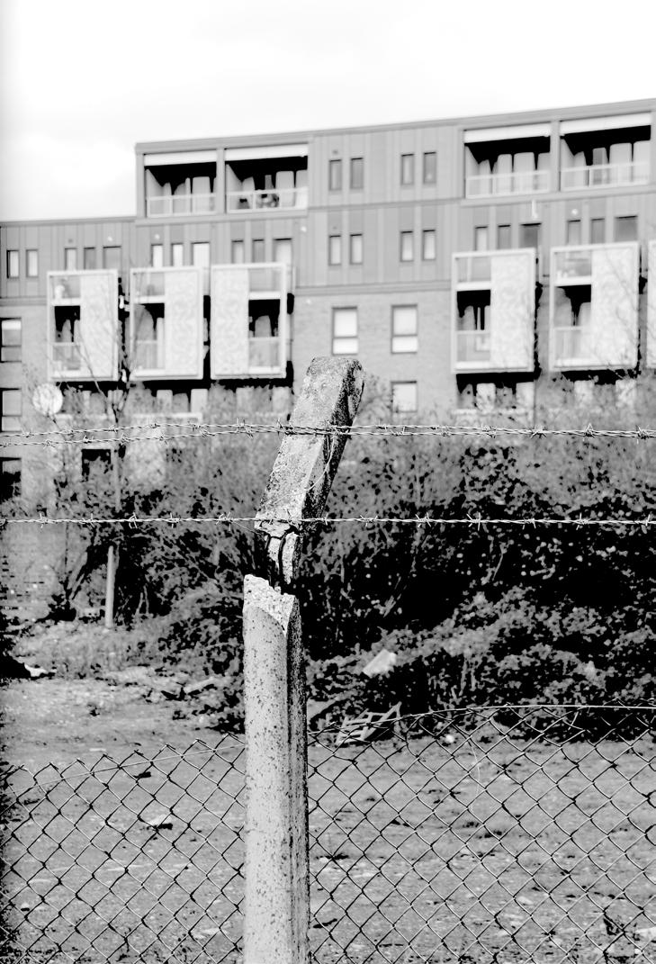
14 Synthesizing Analysis Where is everyday life? This idea of social disjointedness, established through interviews and observation, was a common theme. Though it must be said that the area was observed during a wet and cold London midwinter, few found evidence of a vibrant public life. Pier Parade, witness to a failed market, is bordered by empty shopfronts and contains little life. Royal Victoria Gardens and the park in Beckton provide a green respite, though views on the gardens, in particular, were mixed. Some see the space as a strong community asset, while others talked instead of muggings, street drinking and assaults. Further disrupting the area are leftover spaces, both empty land and buildings. The study area is pockmarked with empty brownfield sites, some of which are residual spaces left over by development, others, in particular Albert Island, are large swathes of neglected space. In the wake of the area s de-industrialisation and changing residential communities, a number of buildings industrial, heritage, and others have been left empty, symbols of an increasingly forgotten history and economic stagnation. The sheer quantity of empty and neglected space and buildings can generate feelings of disharmony, which is further compounded by the difficulty in getting around (Lynch 1960). Figure 16. Abandoned pub in North Woolwich Figure 17. Pier Parade square Figure 14. Street signs and barriers on Pier Road Figure 18. Walls at Royal Victoria Gardens Figure 15. River bank in the new real estate area Figure 19. Path along the river near Royal Victoria Gardens 12

 Figure 21.")
15 Synthesizing Analysis grid and clustered fabric soft-scape hard-scape Figure 20. Grain and porosity (from: Urban Analysis - Infrastructure and Mobility) Figure 21. Priorities map (from: Urban Analysis - Urban Fabric and Landmarks) 13

16 Synthesizing Analysis Whose regeneration? Meanwhile regeneration efforts have been driven by large single-purpose developments, such as the airport and University of East London, motivated by commercial and industrial growth, with little consideration for and tie-in to the locality. Other developments on the horizon, notably the Asian Business Park, seem to follow along that vein. The lack of integration is not helped by the multiple actors influencing the area. From a planning perspective it falls within both Newham Council and the Greater London Authority s remit, with significant and multiple transport quangos also involved, creating conflicting priorities for the area. According to the different documents that lay out the future of the Royal Docks, the planners hope to achieve radical change in the coming years (Royal Docks Spatial Principles, 2011), focused on building a world-class business centre: world leader in high technology, green enterprise and research and an international forum for the exchange of knowledge and ideas (Royal Docks Vision Document, 2011). The repeated reference to the global illustrates how the planner s imagination for the area is largely removed from the local. Possibility for change Many of challenges summarized in this analysis, however, offer possibility for change, grounded in what the eastern end of the Royal Docks is now. The design response laid out in the following pages tries to increase connectivity both social and physical and by doing so, aims to inject some locally sourced energy into the area s everyday life. Economic Activity (commercial, transport, local shops ) Cultural Activity (education, leisure, recreation) Overlapping Activitie (private education, commerce inside educational infrastructure, religious activities inside community centres) Figure 22. Cultural and economic spaces (from: Urban Analysis - Culture and Economies) 14
17 15

18 16 III SWOT Analysis
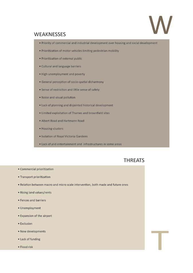
19 17


20 Swot Analysis PRINCIPLES LENSES OF ANALYSIS WEAKNESSES and THREATS Prioritization of motor vehicles limiting pedestrian mobility General perception of sociospatial disharmony HOUSING AND DWELLING Enhance physical and social connectivity Housing-clusters Lack of funding Noise and visual pollution Isolation of Royal Victorian Park URBAN FABRIC AND LANDMARKS Exploit preexisting conditions and potential assets Exclusion Fences and barriers as a way to give a sense of safety Transport prioritization OPEN AND PUBLIC SPACES Employ inclusive, incremental processes, creating possibilities for appropriation 18

 INFRASTRUCTURES AND SPACE OF MOBILITY / IMMOBILITY Promote sustainable economic activities PRINCIPLES LENSES OF ANALYSIS STRENGTHS")
21 Swot Analysis Several Green islands in the concrete, industrialised area Existing landmarks could be catalysts for transformation processes LEFTOVERS AND THRESHOLDS Support urban ecologies Many investment interests on the area Existing quality housing in relatively good condition Numerous Housing Associations CULTURES AND ECONOMIES Embrace difference and provide diversity of spaces Strong support from London Development Agency and London Borough of Newham Existing riverbank paths and views Existing wellplanned open and public spaces (Royal Victoria Park) INFRASTRUCTURES AND SPACE OF MOBILITY / IMMOBILITY Promote sustainable economic activities PRINCIPLES LENSES OF ANALYSIS STRENGTHS and OPPORTUNITIES 19
22 IV Principles & Guidelines After a thorough review of the six urban analysis reports and conducting a SWOT analysis, we concluded that there were three areas that needed to be addressed directly through our design response issues of connectivity, both physical and social; a enlivening of the area s everyday life; and redirecting the focus of the regeneration itself on the locality to make it a place that was desirable to live and visit. As such our principles and guidelines drew from these challenges the area s multiple enclaves needed to be bridged, connectivity vastly improved and opportunities created for social interaction; interventions should address the area s liveliness and livelihood; and they should tap the area s potential found materially in unused resources such as abandoned buildings and, most importantly, the river to generate a sense of identity and ownership. 20
23 21
24 Principles & Guidelines STRATEGIES PRINCIPLES GUIDELINES Enhance physical and social connectivity Enable public appropriation through flexible design. Encourage temporary reuse of empty buildings. Promote regeneration and reuse of heritage buildings and structures and connect them to public spaces. Strengthen specific localities by enhancing the role of existing meaningful elements and practices in the area. Support ecological function of places. Soften the gradient between anthropic spaces and wild spaces to achieve sustainable maintenance and development of the area s open spaces. Exploit pre-existing conditions and potential assets Improve and develop pedestrian, bicycle, and water-based transportation networks. Establish and improve a network of pathways and routes to enhance integration. Consider alternative routes in order to mitigate the impact of infrastructural barriers such as the Crossrail, DLR and City Airport. Reconsider safety and security barriers to improve connectivity. Reconnect the area towards the river to create a landmark of the waterfront. Provide a diverse range of housing solutions in the area in terms of design and social mix. Employ inclusive, incremental processes, creating possibilities for appropriation 22
25 GUIDELINES Principles & Guidelines Support urban ecologies Embrace difference and provide diversity of spaces Promote sustainable economic activities PRINCIPLES Reflect the area s diversity (historical, cultural, economic and social) through a multiple of land uses. Embrace the smooth transition between public and private spaces. Promote new local activities to strengthen the area s social and economic dynamics. Emphasize the importance of the connection and integration of new developments with the public realm and the surrounding elements of the area. Ensure design interventions are integrated with their surroundings. Explore options that promote interaction and local employment. Support the re-activation and creation of social and cultural events to attract people to public space. Promote social encounters with both existing physical elements and the design of new playful spaces. Involve all stakeholders in the preliminary stages of the design and open forums for the citizens to propose ideas and express needs. Ensure that design and implementation processes are transparent and accountable to the affected stakeholders. Promote innovative designs that enable better communication and connection between council and the residents of the area. STRATEGIES 23
26 V Vision Our vision of North Woolwich, Albert Island and Beckton is one of diverse, vibrant integrated localities, enlivened by enhanced connectivity to catalyse change from within. The eastern Royal Docks, now an interrupted sequence of nodes, will be more tightly connected, with an emphasis on intimate networks to direct residents and visitors alike to the area s greatest existing asset indeed the very reason for its existence the River Thames. The area s rich cultural past and present will be tapped to reengage the people living, working and playing in the area, to brighten existing landmarks and spark the creation of new ones. Imaginative interventions will seek to catalyse social interaction, bringing the diverse and overlapping communities together and creating a destination to attract people from around London. Finally, the area will highlight both social and environmental sustainability, incubating local employment and supporting the area s ecological function. In achieving our vision, the eastern Royal Docks North Woolwich, Albert Island and Beckton will be an integral part of the regeneration of the Royal Docks at large, as an area transformed through tapping potential energy found in its local materiality and sociality. Now, introducing our strategies are two maps: the first offers a conceptual representation of our vision for the area; the second provides an overview of our proposed interventions. 24

27 Vision Figure 23. Vision map 25
28 Overview map Carbon sink Roundabout regeneration Re-connecting to water landscape Re-activate Pier Parade square Proposed new crossing on Albert Road 26 Free expression wall Re-activate the Pier The new riverfront promenade


29 Overview map New pedestrian bridge water-borne landmark market under DLR temporary work/incubation space Re use of IVAX building Skate Park BMX park Green Area Event space 27
30 VI Design Response This design response is comprised of four themes: Connectivity; Re-engaging North Woolwich; Re-vitalising Albert Island; and Re-activating Beckton. We have organised our interventions by taking into account the time scale of regeneration, dividing them into short-, medium- and long-term phases, in order to ensure an incremental process of change at the micro, meso and macro scales. The interventions touch on all principles in direct and indirect ways, and are organised geographically, starting in North Woolwich, through Albert Island, to Beckton. However, we are starting with connectivity, our first and most important overarching aim, that addresses the area at a macro scale. This theme will be built on considerably, proposing to improve the pedestrian and bicycle network to generate a human-scale integration for the local area. 28

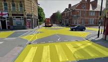
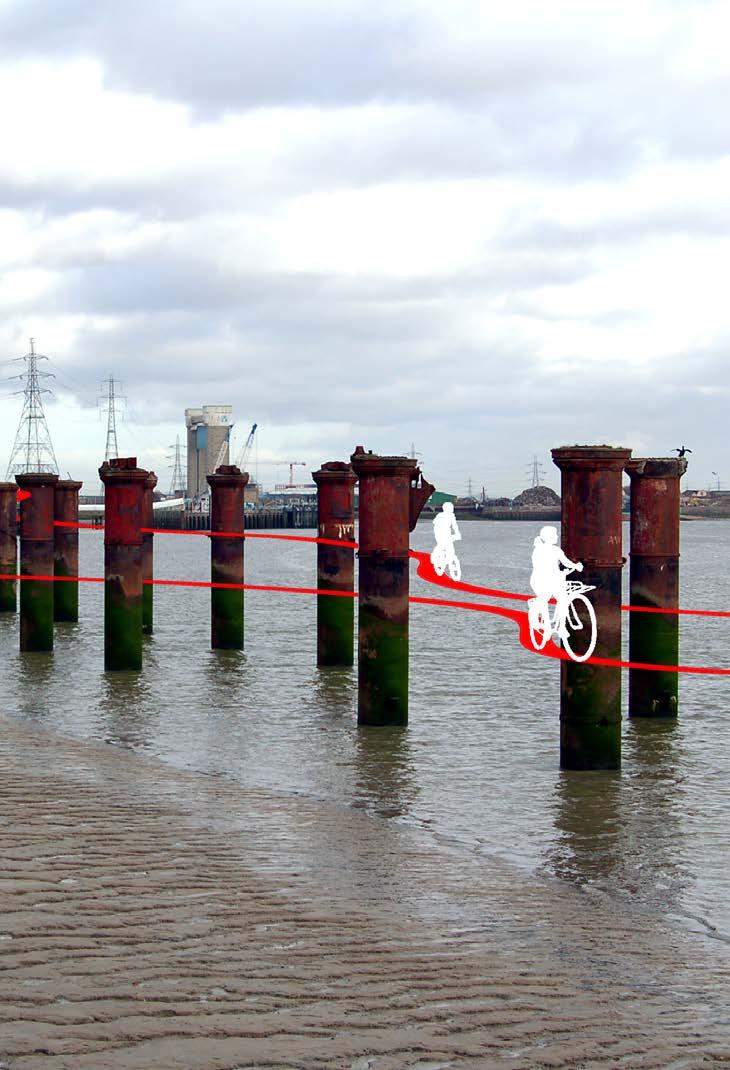
31 Intervention site and Design Response Connectivity One of the eastern Royal Docks greatest challenges is connectivity and legibility at the local level. This series of interventions aims to redress the balance between the car and the pedestrian; between the large-scale infrastructure such as the DLR, Crossrail, the airport and the North Circular, and the locality. The river is used as the principle orienting landmark for eastern Royal Docks as a whole. The interventions aim to re-dimension the city at human-scale through the improvement of pre-existing structures and with the creation of new strategic connections. Other smaller, more local connectivity-driven interventions will be discussed in the other three sections. Redirecting the Woolwich Ferry: Lobbying to redirect the Woolwich Ferry away from North Woolwich to Gallions Reach, as is being considered by Transport for London, would remove the heavy through-traffic along the North Circular, opening up the main roads Albert Road and Woolwich Manor Way for more local use and navigation. It would also permit the opening up of a river walk across the river bank running along the southern side of North Woolwich. Extend the Thames Path: Creating a continuous pedestrian and cycle path along the river bank through the entire study area would improve circulation locally and help attract visitors to the area who are embarking on short or long river walks. Suspend a pedestrian and bicycle bridge along Woolwich Manor Way: This intervention would vastly improve the mobility between Beckton and North Woolwich, currently an uncomfortable experience thanks to the heavy traffic, particularly lorries, that dominate the bridge. Develop cycle paths throughout: Marking out cycle paths connecting the different nodes (King George V DLR to the river; along the inner waterways bordering North Woolwich, Albert Island and Beckton; and from Gallions Reach DLR to the river) improves connectivity and offers transportation alternatives. Improve pedestrian crossings: Using simple, brightly coloured, painted road crossings at the Albert Road and Pier Road intersection and at the Gallions roundabout will visibly reassign some road priority to pedestrians, also directing them towards the various local landmarks. Develop a bicycle/running path: Developing a running path along the inner waterway between the former King George V Dock and Royal Albert Dock (in essence running around the City Airport runway island) would create an asset of the airport, currently a difficult neighbour for the area. Our aims with the connectivity interventions are to reinstate the locality as central to the area s infrastructure, increasing permeability, and subsequently, interaction. Figure 24. Proposed new path along the river and through the old pillars on the water 29

32 Intervention Site and Design Response Figure 25. Connectivity map: network of existing infrastructure to improve and proposed strategic connections 30

33 Intervention Site and Design Response 31

34 Re-engaging North Woolwich Intervention site and Design Response 1 Though North Woolwich has several significant landmarks Pier Parade Square, the Royal Victoria Gardens, the riverfront, and several heritage buildings poor pedestrian connectivity and further disruption caused by traffic along Albert Road and the Crossrail has negatively impacted the area s sociality. We have focused on micro-level strategies that can be scaled up through their interconnectivity, aiming to re-engage the local residents with the area, fostering a sense of ownership and participation. In Pier Parade Square, now a sterile grey space, we will employ a landmark sculpture to help a sense of identity, introduce movable furniture to allow users appropriate the space (Whyte 1980). Further appropriation will be possible on the north side of North Woolwich. A new Thames Path and re-use of the North Woolwich Station and pier will create a destination while referencing the area s heritage and re-orienting the area towards the river. We utilize other empty space to create a community garden, adding ecological value and involving locals in an engaging place-making activity. Short term install movable furniture and green landscaping to Pier Parade Square install central landmark to Pier Parade Square promote policy of allowing for a short-term rental policy for empty shopfronts to encourage locals to try out business ideas enlist community infrastructure to set up pocket garden in the empty land sitting at the southern end of Woolwich Manor Way Bridge Mid term open the riverfront promenade from North Woolwich through to Albert Island invite street artists to decorate wall that borders the Thames Path; keep open for evolution strengthen pier and turn into viewing point with cafe kiosk build the Pocket Park, using recycled materials from the local area to build the beds Long term reconnect North Woolwich Station to Royal Victoria Gardens install panes of plexiglass into the brick wall on the Thames for more open viewing clear the industrial land on the northern side of North Woolwich facing the airport to create opportunity for appropriation Figure 26. Re-activate the pier 2 Figure 27. The new riverfront promenade 3 Figure 28. Re-activate Pier Parade square 4 Figure 29. Proposed new crossing on Albert Road 32


35 Intervention site and Design Response NORTH WOOLWICH INTERVENTION MAP Figure 30. Strategic map - North Woolwich 5 Figure 31. Free expression wall 6 Figure 32. Re-connecting to water landscape: King George V dock Figure 33. Location map-north Woolwich 33


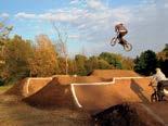
36 Re-vitalizing Albert Island Intervention site and Design Response 1 Albert Island empty, neglected, mysterious already has something of an appropriated space, the BMX park, which provides an interesting entry point for the further expansion of a sports and leisure profile for the space. Our strategy aims to transform Albert Island into a flexible place that permits further appropriation by local residents, UEL students and visitors from elsewhere. Continuing the theme of sports already present with the BMX and the marina, there will be a skateboard park and the warehouse could eventually shelter an outdoor pool. A meadow will lead down to the Thames Path and the river, opening up space for events, small and large. In the small peninsula of space on the other side of the bridge, there will be small, hardy trees and grasses to creating a small carbon sink to relieve City Airport s high carbon dioxide emissions. Short term remove fences that enclose the Thames Path and redirect the Path across the meadow level out the land s gradient from the river to create a gradual transition from the center of the island to the waterfront create open space events area picnic tables for meadow build public restrooms Mid term build skateboard park plant wildflowers at the waterfront meadow create and maintain green landscape at the waterfront create carbon sink in the western-most peninsula Long term convert the warehouse to outdoor swimming pool expand activity offfering to other water sports, such as kayaking Figure 34. Outdoor swimming pool 2 Figure 35. Skate park 3 Figure 36. BMX Park 4 Figure 37. Event space 5 Figure 38. Re connecting to the water landscape 34


37 Intervention site and Design Response ALBERT ISLAND INTERVENTION MAP A 4 5 A Figure 39. Strategic map - Albert Island AA Figure 40. The Meadow Figure 41. Location map - Albert Island 35
 to increase the student housing stock.")

38 Re-activating Beckton Intervention site and Design Response 1 The southwestern area of Beckton will serve to pull people in from the inland of the Royal Docks while actively dialoguing with the River Thames. New mixed-tenure housing will run towards the river; while the former IVAX building will be converted (and perhaps vertically expanded) to increase the student housing stock. The Thames Path will continue to curve around; bicycle paths will connect to the river along Atlantis Avenue, connecting the waterfront to the rest of Beckton. A weekly market located under the DLR can provide opportunities for local residents for social and economic interaction. Our most provocative intervention is the conversion of a factory into temporary work/ incubation space. The architectural concept is to open the building up by removing the walls and then bringing water in through covered canals, which can then house small temporary work pods and art spaces. The aim is to subvert the perception of the area s different landmarks, reactivating the area s relationship with the water. The hope is the building will attract local business ideas, interaction with UEL and attract visitors from outside. Short term connect the pylons to create a water-borne landmark extend the Thames Pathway to anchor a new waterfront organize occasional market under the DLR at the Gallions roundabout extend bicycle paths along Atlantis Avenue and into New Beckton Park Mid term reuse the IVAX building as student housing redesign Gallion roundabout with bright painted crosswalks to facilitate pedestrian and bicycle access Long term redevelop the factory into temporary reuse space redevelop the waterfront with mixed-tenure buildings open towards the river expand IVAX building through vertical additions Figure 42. Roundabout regeneration 2 Figure 43. Water borne Landmark 3 Figure 44. Re use of IVAX building 4 Figure 45. Temporary work/incubation space 36


39 Intervention site and Design Response BECKTON INTERVENTION MAP 4 3 Figure 46. Strategic map - Beckton Figure 47. Location map - Beckton 37
40 VI Conclusion Through our analysis, we found the eastern Royal Docks comprised of North Woolwich, Albert Island and Beckton to feel in many ways like a large leftover. Cut off by large infrastructure projects, with poor interconnections, a shifting population, and a complicated land ownership structure, it has been unable to gain any internal traction. Meanwhile, some of its multiple planning authorities see its leftover position as an opportunity to ignore its needs (as seen in expansion plans at City Airport, Crossrail s cutting it in two without stopping, planning large business driven projects such as the Asian Business Park). Our design response, as laid out in the previous pages, aims to redress the balance. Connectivity driven strategies aim to facilitate interaction. We looked at enhancing and creating nodes to develop a sense of place grander ones such as the Woolwich Pier and Albert Island to attract visitors from the outside; and more intimate ones, such as Pier Parade Square and a community garden, for local residents, workers, and students. We conceived strategies to incubate local businesses through the reuse of existing structures. The eastern Royal Docks face tough challenges, principally through the detracting nature of City Airport and the disruption of Crossrail, which has ripple effects on the area s housing, sociality and connectivity. However, through our strategies working to leverage existing assets and unleashing unrecognized potential we feel these challenges can be met, and that the diversity of North Woolwich, Albert Island and Beckton can serve as attractor, making it a lively, interesting place to live, work, study and visit. 38
41 39
42 List of Figures Figure 1. Real estate south of Albert Island 6 Figure 2. Empty lot near the Crossrail site 6 Figure 3. King George V DLR station 6 Figure 4. Danger sign on private property gate 6 Figure 5. Housing in North Woolwich 6 Figure 6. Pier Road 6 Figure 7. Abandoned pier 6 Figure 8. Historic station and railway museum near the pier 6 Figure 9. Aereal view of the Royal Docks from east (from: Vision for the Royal Docks) 7 Figure 10. Embodiment map (from: Urban Analysis - Infrastructure and Mobility) 9 Figure 11. Macro scale map: leftovers and thresholds (from: Urban Analysis - Thresholds and Leftovers) 10 Figure 12. Map of abandoned buildings (from: Urban Analysis - Housing and Dwelling) 11 Figure 13. Built up, vacant and open spaces (from: Urban Analysis - Housing and Dwelling) 11 Figure 14. Street signs and barriers on Pier Road 12 Figure 15. River bank in the new real estate area 12 Figure 16. Abandoned pub in North Woolwich 12 Figure 17. Pier Parade square 12 Figure 18. Walls at Royal Victoria Gardens 12 Figure 19. Path along the river near Royal Victoria Gardens 12 Figure 20. Grain and porosity (from: Urban Analysis - Infrastructure and Mobility) 13 Figure 21. Priorities map (from: Urban Analysis - Urban Fabric and Landmarks) 13 Figure 22. Cultural and economic spaces (from: Urban Analysis - Culture and Economies) 14 Figure 23. Vision map 25 Figure 24. Proposed new path along the river and through the old pillars on the water 29 Figure 25. Connectivity map: network of existing infrastructure to improve and proposed strategic connections 30 Figure 26. Re-activate the pier 32 Figure 27. The new riverfront promenade 32 Figure 28. Re-activate Pier Parade square 32 Figure 29. Proposed new crossing on Albert Road 32 Figure 30. Strategic map - North Woolwich 33 Figure 31. Free expression wall 33 Figure 32. Re-connecting to water landscape: King George V dock 33 Figure 33. Location map - North Woolwich 33 Figure 34. Outdoor swimming pool 34 Figure 35. Skate park 34 Figure 36. BMX Park 34 Figure 37. Event space 34 Figure 38. Re connecting to the water landscape 34 Figure 39. Strategic map - Albert Island 35 Figure 40. The Meadow 35 Figure 41. Location map - Albert Island 35 Figure 42. Roundabout regeneration 36 Figure 43. Water borne Landmark 36 Figure 44. Re use of IVAX building 36 Figure 45. Temporary work/incubation space 36 Figure 46. Strategic map - Beckton 37 Figure 47. Location map - Beckton 37 40
43 Bibliography Literature references Graham S. and Marvin S. (2001) Splintering Urbanism: networked infrastructures, technological mobilities and the urban condition, London: Routledge. Lynch, K. (1960) The Image of the City, London: MIT Press. Whyte, W. (1980) The social life of small urban spaces, Washington, D.C.: Conservation Foundation. Official documents Bird, E. (2010) Heritage Scoping Study of the Royal Docks Masterplan Area, Parts I, II, and III, London: London Development Agency. [Online resource]. Available at: regeneration/publications-guidance/heritage-reports. Royal Docks: Parameters for Development (2011). [Online resource]. Available at: sites/default/files/royal%20docks%20parameters%20for%20development.pdf Royal Docks: a vision for the Royal Docks prepared by the Mayor of London and the Mayor of Newham (2010). [Online resource]. Available at: planning/royaldocksavisionfortheroyaldocks[1].pdf. Royal Docks: Spatial Principles (2011) [Online resource}. Available at: files/royal_docks_spatial_22%2008%2011.pdf Urban analysis reports DPU (2014) North Woolwich, Albert Island & Beckton Urban Analysis - Housing and Dwelling DPU (2104) North Woolwich, Albert Island & Beckton Urban Analysis Culture and Economies DPU (2014) North Woolwich, Albert Island & Beckton Urban Analysis- Infrastructures and Mobility DPU (2014) North Woolwich, Albert Island & Beckton Urban Analysis - Leftovers and Thresholds DPU (2014) North Woolwich, Albert Island & Beckton Urban Analysis - Open and Public Spaces DPU (2014) North Woolwich, Albert Island & Beckton Urban Analysis - Urban Fabric and Landmarks 41
BLOK BADEL ZAGREB. Competition for the urban-architectural concept design for the BADEL SITE redevelopment COMPETITION NUMBER: ZG-UA
 BLOK BADEL ZAGREB Competition for the urban-architectural concept design for the BADEL SITE redevelopment COMPETITION NUMBER: 136-12-ZG-UA 1.0 DESCRIPTION AND EXPLANATION OF THE OVERALL CONCEPT The Badel
Tauranga City Centre Spatial Framework
 Tauranga City Centre Spatial Framework Stakeholder Engagement Workshop 15 October 2015 Project Design Team Beca & LandLAB Our team Henry Crothers (LandLab) Landscape Architect/Urban Designer Urban and
CHAPTER 8 ISSUES, CONCERNS, CONSTRAINTS AND OPPORTUNITIES
 CHAPTER 8 ISSUES, CONCERNS, CONSTRAINTS AND OPPORTUNITIES Introduction This River Conservation Plan was developed during a time of tremendous activity and effort in planning the transformation of the Delaware
Response to the London Bridge Area Vision and Site Allocations within the New Southwark Plan
 1 Melior Place London SE1 3SZ 020 7407 4701 teamlondonbridge.co.uk info@teamlondonbridge.co.uk 28 April 2017 Response to the London Bridge Area Vision and Site Allocations within the New Southwark Plan
1 October Dear Citizens of Charlotte and Mecklenburg County,
 1 October 2011 Dear Citizens of Charlotte and Mecklenburg County, As co-chairs of the Center City 2020 Vision Plan Steering Committee, we are proud to present the Center City 2020 Vision Plan, which sets
ARISE: The Rock Renaissance Area Redevelopment & Implementation Strategy
 2014 Professional Awards 1 ARISE: The Rock Renaissance Area Redevelopment & Implementation Strategy Janesville, WI Completed December 2014 Analysis & Planning Purpose of Project 2 The purpose of the Rock
Inspiring Technovation
 1 2 Table of content List of table and figures... Executive summary... 1. Introduction... 2. Material and methods... 3. Results... 3.1 Today s facts about Versailles: a diagnostic approach... 3.1 Vision
01 the vision NEW LYNN IS WAITING FOR THE GREAT LEAP FORWARD
 [A] FRAMEWORK 01 the vision 02 the framework 03 urban design principles 04 c o n t e x t 05 issues a n d o p p o r t u n i t i e s 06 creating a t.o.d. 07 key recommendations 08 seven strategic areas of
SUB AREA 3 CENTRAL STRATFORD AND SOUTHERN QUEEN ELIZABETH OLYMPIC PARK
 191 ADOPTED LOCAL PLAN: THE SUB AREAS SUB AREA 3 CENTRAL STRATFORD AND SOUTHERN QUEEN ELIZABETH OLYMPIC PARK SECTION 12 Vision VISION Central Stratford and Southern Queen Elizabeth Olympic Park will become
Sub-committee on Harbour Plan Review of Harbour-front Enhancement Committee. Ninth Meeting
 Sub-committee on Harbour Plan Review of Harbour-front Enhancement Committee Ninth Meeting Date: 5 October 2005 Time: 3:30pm Venue: Conference Room 15/F, North Point Government Offices, 333 Java Road, North
97 Lea Bridge Road, Leyton, E10 7QL London Borough of Waltham Forest December 2015
 97 Lea Bridge Road, Leyton, E10 7QL London Borough of Waltham Forest December 2015 Public Realm and Landscape Proposals LEA BRIDGE ROAD, WALTHAMSTOW Public Realm & Landscape Proposals BDP(90)RPT001 December
V. Vision and Guiding Principles
 V. Vision and Guiding Principles The Master Plan for the Powers Ferry Corridor seeks a foundation in the desires of the community. At times, various elements of the community offered opposing viewpoints,
London Bridge London Bridge Area Vision Map
 Area Vision Map Borough Market Southwark Cathedral NSP54 Hay s Galleria Key: NSP Site Allocations Greenspace Low Line Thames Path Cycle Network Primary Shopping Areas Borough High Street Tube Station NSP51
10.0 Open Space and Public Realm
 10.0 Open Space and Public Realm 10.0 Open Space and Public Realm The Public Open Space System is comprised of: outdoor spaces available for public use that are either publicly owned (e.g., parks and
Horwood Map of London, Westminster & Southwark First edition
 Barratt London is developing plans in tandem with Southwark Council and TfL to transform the southern end of Blackfriars Road. The residential-led, mixed-use scheme will deliver new private and affordable
Ivywild On The Creek PRELIMINARY CREEK DISTRICT MASTER PLAN
 Ivywild On The Creek PRELIMINARY CREEK DISTRICT MASTER PLAN Introduction: Rejuvenating an extraordinary Creekside neighborhood THE CREEKSIDE DISTRICT The Ivywild On The Creek Neighborhood District Master
Inclusive and Engaging City
 Inclusive and Engaging City An Inclusive City welcomes and enables all people to participate fully in City life. Population, housing, services, social inclusion and liveability are important elements of
Chapter 5 Urban Design and Public Realm
 5.1 Introduction Public realm is all areas of the urban fabric to which the public have access. It is where physical interaction takes place between people. It therefore, includes buildings and their design,
Market Place Bythell Place Queen Street Park Riverside Park. Public Spaces. Blenheim CBD Streetscape Final Report 36
 37 39 41 43 Market Place Bythell Place Queen Street Park Riverside Park Final Report 36 Market Place Market Place is a key space for Blenheim s street life, it is a meeting place, retail edge and pedestrian
Downtown Streetscape Manual & Built Form Standards
 City of Guelph Downtown Streetscape Manual & Built Form Standards July 2014 Prepared by Brook McIlroy Inc. in association with Unterman McPhail Associates and McCormick Rankin Inc. City of Guelph Downtown
Phase 1 : Understanding the Campus Context. Phase 2 : APPROACHES - Alternates & Preferred Plan
 Introduction MASTER PLAN PURPOSE WHY A CAMPUS MASTER PLAN? The purpose of the Master Plan at the University of Illinois at Chicago is to translate UIC s strategic goals and objectives into a compelling
OUR AREA SECTION 02 I NEXT PAGE. 2.1 This section sets the scene in regard to the role of the Legacy Corporation and the baseline
 7 ADOPTED LOCAL PLAN SECTION 02 2.1 This section sets the scene in regard to the role of the Legacy Corporation and the baseline position of the Local Plan. It sets out the historical context and current
13. London Bridge London Bridge Area Vision
 13. 13.1. Area Vision 13.1.1. is: A globally significant central London business district which is home to international business headquarters; Internationally renowned for its prominent riverfront location
0 9 Areas of Change 59
 09 Areas of Change 59 09 Areas of Change This section explores seven areas of change within Solihull Town Centre which provide practical interventions in order to deliver the emerging concepts outlined
SALISBURY TOMORROW Our Vision
 SALISBURY TOMORROW Our Vision Salisbury is committed to supporting a high quality of life and sense of community for all residents. These commitments need to be reflected in our community programs, services
2. reimagine kings way undercroft as a community space
 2. reimagine kings way undercroft as a community space CLARENDON STREET CLARKE STREET QUEENS BRIDGE STREET MORAY STREET CITY ROAD BALSTON STREET BOYD KINGS WAY POWER STREET KAVANAGH WEST GATE FREEWAY Figure
Chapter 03 Planning framework
 Vauxhall Nine Elms Battersea Opportunity Area Planning Framework Chapter 03 Planning framework Mayor of London 25 preferred option - 16,000 residential units 20,000-25,000 jobs northern line extension
11TH STREET BRIDGE PARK COMPETITION
 11TH STREET BRIDGE PARK COMPETITION DESIGN PRINCIPLES, VALUES AND FACILITIES DESCRIPTION The design principles and list of facilities for a future 11th Street Bridge Park have been gathered through over
Practices about Site:
 Practices about Site: Reflecting on the design of the Museum of Liverpool Fig 01. The Museum of Liverpool Picture from official website of the 3XN Yuan Chen 100202902 MAAD University of Sheffield 4th May,
New-Cast Mixed-use Development Proposal King Street West, Newcastle, Ontario
 URBAN DESIGN BRIEF New-Cast Mixed-use Development Proposal King Street West, Newcastle, Ontario TABLE OF CONTENTS: 1.0 Executive Summary 2.0 Creating Vibrant and Sustainable Urban Places: Excerpts from
1. PLANNING CONCEPTS. Central Petaluma Specific Plan Chapter 1. Planning Concepts Page 7
 Page 7 1. PLANNING CONCEPTS Overview of Planning Concepts The plan for Central Petaluma envisions a reinvigorated central district that accommodates a greater diversity and intensity of activities, including
Streets, Connectivity & Built Environment Working Group August 2, 2017
 Streets, Connectivity & Built Environment Working Group August 2, 2017 DOWNTOWN OAKLAND SPECIFIC PLAN WELCOME Streets, Connectivity & Built Environment Working Group Social Equity Meeting August 2, 2017
Blood Alley Square/Trounce Alley Redesign
 June 216 Kick-Off Events Questionnaire and Engagement Summary Background The City of Vancouver is redesigning Blood Alley Square and Trounce Alley, important public spaces in the heart of Gastown, which
WELLINGTON STREET WEST COMMUNITY DESIGN PLAN
 36 3.CDP POLICIES 37 Wellington Street West CDP Vision Statement 38 3.1 Introduction 3.1.1 Purpose The development of buildings and public spaces is influenced by a variety of factors over time. City of
Scottish Natural Heritage. Better places for people and nature
 Scottish Natural Heritage Better places for people and nature Contents Summary... 3 SNH approach... 5 Place-making in policy and practice... 6 Developing the contribution of the natural heritage to place-making...
A Vibrant Downtown. Chapter 5 Cary Public Art Opportunities 31
 A Vibrant Downtown Cary s vision for Downtown is a unique, vibrant, dynamic, pedestrian friendly location; a regional destination and a place to live, work, and recreate, according to the 2001 Town Center
A. The sites in Table 16 below, as identified on the Policies Map, are allocated for retail-led development:
 SWDP 44: Worcester City Centre A. The sites in Table 16 below, as identified on the Policies Map, are allocated for retail-led development: Table 16: Sites Allocated for Retail-Led Development Policy Reference
REPORTING BACK TO YOU ON THE RIG NETWORK SURVEYS A snapshot of findings
 REPORTING BACK TO YOU ON THE RIG NETWORK SURVEYS A snapshot of findings We d like to thank everyone who participated in RIG Network s recent surveys and who sent the survey information on to other people.
Clair-Maltby Community visioning
 Clair-Maltby Community visioning workshop #1 Summary April 27th, 2017 Table of Contents INTRODUCTIon 1 PURPOSE 1 CONSULTATION STRUCTURE 2 PARTICIPANT FEEDBACK 3 VISIONING EXERCISE 8 ONLINE SURVEY RESULTS
Heads up Versus Heads Down Retail: the missing link between good public spaces and good markets?
 Heads up Versus Heads Down Retail: the missing link between good public spaces and good markets? Much can be learned about what makes places great by observing successful markets - and vice versa Project
Plano Tomorrow Vision and Policies
 Plano Tomorrow Vision and Policies PLANO TOMORROW PILLARS The Built Environment The Social Environment The Natural Environment The Economic Environment Land Use and Urban Design Transportation Housing
iii. Visioning framework
 III. VISION iii. Visioning framework III.1 Overview A vision is a clear and succinct description of what an institution and its community should look like after it successfully implements its goals and
PART 1. Background to the Study. Avenue Study. The Danforth
 The Danforth 1.1/ Study Purpose & Key Municipal Goals 1.2/ The Local Advisory Committee 1.3/ The Project Team 1.4/ Study Process/Summary of Method 1.5/ Summary of Consultation 1.1 Study Purpose and Key
elbridge Core Strategy
 C elbridge Core Strategy Celbridge is designated as a Moderate Growth Town in the RPGs. The County Development Plan reinforces this designation in its settlement strategy. Moderate Growth Towns within
Highest & Best Use Study Marina Park Lands
 Executive Summary of Report MARCH 2006 TABLE OF CONTENTS 1. Introduction...1 2. Study Process...2 3. Highest And Best Use Program...3 4. Concept Plan...8 5. Public Area Animation...9 6. Marina Park Implementation
Elliot Park 4. Neighborhood Master Plan. The Master Plan
 Elliot Park 4 Neighborhood Master Plan August 2002 Why Master Plan? Construction cranes signal new growth downtown as the backdrop to this smaller scale, quiet neighborhood. Do nothing or plan for the
URBAN DESIGN BRIEF NORTHVIEW FUNERAL HOME HIGHBURY AVE N, LONDON, ON
 URBAN DESIGN BRIEF NORTHVIEW FUNERAL HOME - 1490 HIGHBURY AVE N, LONDON, ON 1.1Purpose The intent of the following report is to identify an opportunity for redevelopment of two residential properties within
WINCHESTER TOWN 3.1 LOCATION, CHARACTERISTICS & SETTING
 WINCHESTER TOWN 3.1 LOCATION, CHARACTERISTICS & SETTING 3.1.1 The area referred to by the City Council, as Winchester Town, consists of the Winchester Wards plus the adjoining built up areas of Badger
WEST OAKLAND SPECIFIC PLAN Final Plan. 2. Vision & Goals. 2.1 Community-Based Goals and Objectives
 WEST OAKLAND SPECIFIC PLAN Final Plan 2. Vision & Goals 2.1 Community-Based Goals and Objectives June 2014 2: Vision & Goals The vision of the West Oakland Specific Plan is to see this remarkable community
PUTTING THE HEART INTO BATTERSEA. A vision
 PUTTING THE HEART INTO BATTERSEA A vision INTRODUCTION This document is a vision for creating a Battersea that its community can be proud of and it is about putting Battersea on the map. It is being proposed
UNION STUDIO Greater Kennedy Plaza!
 April May 2013 UNION STUDIO Greater Kennedy Plaza! It s time: Providence s civic plaza and transit hub is re-imagined as a vibrant urban gathering place 1 Kennedy Plaza Reborn THE TEAM Client: The City
Midtown Greenway Land Use and Development Plan Executive Summary
 Midtown Greenway Land Use and Development Plan Executive Summary Introduction The Midtown Greenway Land Use and Development Plan sets policy direction for land use and development in the Midtown Greenway
York Road Arial View
 Arial View Bridge Ave YORK ROAD THE SITE TODAY View west down View west from View east The 1.5 ha site is located south of the and to the east of Queen Street. The site includes an existing car park, disused
Growth Point Connectivity: Executive Summary
 Growth Point Connectivity: Executive Summary Background to the study This study addresses issues in the rural west of the Region. It focuses on Telford, Shrewsbury and Hereford, which as Growth Points
Background Information
 Background Information view at site entrance THE LONDON BOROUGH OF SUTTON As the strategic local authority the Council is working with a range of partners to take forward various development sites in Hackbridge.
3.1 Existing Land Use
 3.0 Land Use This strategy has been developed taking into account the position of the Town of Sidney as the economic center of the Saanich Peninsula. It acknowledges existing land use patterns in the downtown
3.9 Systems Interrelationships
 191 Sustainability Building Blocks: The Comprehensive Plan Systems Community Form Economy Social Transportation Natural Resources Housing and Neighborhoods Utilities and Infrastructure Institutions.9 Systems
Western City District What we heard
 What we heard Vision to 2056 and Priorities Governance and implementation Infrastructure and funding The protection of the natural landscape including biodiversity and the Metropolitan Rural Area for food
Rochford District Council Allocations Development Plan Document: Discussion and Consultation Document Sustainability Appraisal
 Option SWH1 Balanced Communities Option SWH1 1 To ensure the delivery of high quality sustainable communities where people want to live and work Will it ensure the phasing of infrastructure, including
38 Queen s University Campus Master Plan Part 1
 38 Queen s University Campus Master Plan Part 1 46 The Campus at the City Scale Chapter 4 The Campus at the City Scale 39 Queen s is an urban University centrally located in Kingston. Decisions made by
Queensborough Eastern Neighbourhood Node. Community Open House
 Queensborough Eastern Community Open House The Vision The Queensborough Eastern will become the heart of eastern Queensborough. Through a sensitive mix of viable commercial and residential areas, the neighbourhood
Bus Rapid Transit Backgrounder. December 2016
 Bus Rapid Transit Backgrounder December 2016 Background The City of London is completing the second stage of Shift, its public transit planning exercise. Shift, focuses on rapid transit, along with vehicular
(Y)OUR BROOMIELAW SUMMARY DOCUMENT
OUR BROOMIELAW SUMMARY DOCUMENT") (Y)OUR BROOMIELAW SUMMARY DOCUMENT Glasgow City Centre District Regeneration Frameworks Broomielaw District August 2018 Broomielaw District Regeneration Framework as defined in Glasgow City Centre Strategy
(Y)OUR BROOMIELAW SUMMARY DOCUMENT Glasgow City Centre District Regeneration Frameworks Broomielaw District August 2018 Broomielaw District Regeneration Framework as defined in Glasgow City Centre Strategy
City of Long Beach. creating vibrant and exciting places
 City of Long Beach creating vibrant and exciting places Land Use Element Urban Design Element Overview of the two draft General Plan elements Discuss areas of change Economic goals of the plans Case study
ELMVALE ACRES SHOPPING CENTRE MASTER PLAN
 ELMVALE ACRES SHOPPING CENTRE MASTER PLAN Contents 1.0 INTRODUCTION... 2 2.0 LOCATION... 2 3.0 EXISTING CONTEXT... 2 4.0 VISION & GUIDING PRINCIPLES... 2 5.0 LAND USE AND BUILT FORM... 4 5.1 St. Laurent
RESOURCE PACKET River Crossing
 RESOURCE PACKE River Crossing Overall Project Focus: "River Crossing" project is funded through an NEA Our own grant that provides a comprehensive plan for public art and arts experiences that will connect
Community Assistantship Program. Milaca Downtown Revitalization
 Community Assistantship Program Milaca Downtown Revitalization Prepared in partnership with City of Milaca Prepared by Zachary Jorgensen Research Assistant University of Minnesota December, 2009 CAP Report
2.0 Strategic Context 4
 2.0 Strategic Context 4 2.1 The Area Action Plan is a non-statutory plan, which forms a corporate policy document, expressing particular issues and areas of concern while also providing a vision for the
3.3. Urban Structure Defining a New Hierarchy of Routes and Spaces >Images
 Section 3.0 I The Masterplan Framework 18 >Images Examples of high quality routes and spaces 3.3. Urban Structure The success of any masterplan lies in a clear definition of the future urban structure
The urban block as a potential for sustainable urban design
 The Sustainable City X 69 The urban block as a potential for sustainable urban design M. Oikonomou Department of Urban Planning and Regional Development, Aristotle University of Thessaloniki, Greece Abstract
EXECUTIVE SUMMARY EXECUTIVE SUMMARY
 1 EXECUTIVE SUMMARY EXECUTIVE SUMMARY Penn s Landing is envisioned as a welcoming riverfront green space adjacent to a refurbished civic marina becoming the centerpiece for adjacent development. With a
Animating the Rideau Canal December 2013
 Executive Summary Animating the Rideau Canal December 2013 Why study the Rideau Canal? The Rideau Canal has been an important part of Ottawa throughout its history, and has shaped and been shaped by the
PLAN ELEMENTS WORKSHOP. April 5, 2016
 PLAN ELEMENTS WORKSHOP April 5, 2016 needs more housing. But there is no one-size fits-all solution. Every neighborhood has its own character. In some places, density is not only appropriate it is badly
Hobart A Strategic Framework
 Hobart 2025 A Strategic Framework Adopted by the Hobart City Council 15 October 2007 Table of Contents Introduction...2 Vision and Future Directions...3 FD1 Offers opportunities for all ages and a city
- Document 2 - Algonquin Interpretation and The Continuing Conversation toward a Vision for a Revitalized Lansdowne
 140 - Document 2 - Algonquin Interpretation and The Continuing Conversation toward a Vision for a Revitalized Lansdowne On May 4, 2012, the City of Ottawa participated in a Forum with a number of Elders,
3. Endorse the LRT vision in transforming Surrey into Connected-Complete-Livable communities, and more specifically, the official vision statement:
 CORPORATE REPORT NO: R038 COUNCIL DATE: February 20, 2017 REGULAR COUNCIL TO: Mayor & Council DATE: February 16, 2017 FROM: General Manager, Engineering FILE: 8740-01 SUBJECT: Surrey Light Rail Transit
Our City Centre is a vibrant, creative and welcoming destination, with a modern business, cultural, shopping, leisure and residential offer
 3. Sheffield in 2034 Our City sits at the heart of a strong, distinctive and internationally successful City Region economy which supports innovation and enterprise Our City Centre is a vibrant, creative
EVALUATION OF MASTER PLAN ALTERNATIVES
 7 The Environmental Report is required to identify, describe and evaluate reasonable alternatives, taking into account the objectives and geographical scope of the Master Plan 2008. Three plan alternatives
Rotherhithe Rotherhithe Area Vision Map
 Area Vision Map CWAAP1 Improved pedestrian and cycle links to the wider area Improved link from town centre to River Thames and docks CWAAP2 Brunel Museum NSP79 CWAAP3 Proposed Thames Crossing Station
Strategic plan framework Steering Committee Meeting
 Strategic plan framework Steering Committee Meeting September 26, 2018 1 agenda 1 Welcome and Strategic Planning introductions Process Strategic Analyses Plan Framework 2 3 Brand Brand Development Naming
Mini Technical Assistance Panel. Rock Spring Park
 Mini Technical Assistance Panel Rock Spring Park May 22, 2013 The Team Jason Bonnet, Forest City Washington Matthew Flis, Town of Vienna William Herbig, National Capital Planning Commission Sophie Lambert,
OUR GREATER SYDNEY A metropolis of three cities. OVERVIEW. connecting people. DRAFT Greater Sydney Region Plan
 OUR GREATER SYDNEY 2056. A metropolis of three cities. OVERVIEW. connecting people. DRAFT Greater Sydney Region Plan October 2017 This document is an overview of the draft Greater Sydney Region Plan. To
heuston gateway: sections heuston gateway: regeneration strategy and development framework plan
 B B1 A B1 B C A heuston gateway: sections B B1 C 117 4.3.3 Zoning The station is the central hub of the area and this function must be preserved and developed. However large areas of the Heuston Station
Public Workshop 2 December 11, 2014 OLIN
 Public Workshop 2 December 11, 2014 OLIN TRIPLE IMAGE PANORAMA A NEW VISION FOR THE RIVERFRONT PROMENADE Burlington s Riverfront has historically been a defining character of the City s identity. This
South District Plan OVERVIEW
 OUR GREATER SYDNEY 2056 Revised Draft South District Plan OVERVIEW Canterbury-Bankstown Georges River Sutherland Snapshot of the South District today and into the future The Greater Sydney Commission acknowledges
BROOKLYN PARK / 85TH AVE LRT STATION CDI DEVELOPMENT GUIDELINES DRAFT
 August 2018 Page intentionally left blank The Brooklyn Park Library adjacent to the 85th Ave LRT Station Area. OVERVIEW The Blue Line LRT Extension / Bottineau corridor offers a unique opportunity to leverage
PUBLIC REALM STUDY AREA
 WELCOME PUBLIC REALM STUDY AREA WHAT IS PUBLIC REALM? Welcome to the Ballina Town Public Realm public consultation event. Mayo Council is in the process of producing a Public Realm Strategy for Ballina
SWLP 42: Worcester City Centre
 SWLP 42: Worcester City Centre A. The following sites are allocated for retail development (as shown on the Proposals Map): Policy Reference SWDP7/1 SWDP7/2 SWDP7/3 Sites allocated for retail development
Guiding Principles. People dance, and to share culture. Place consistency and internal connections. Management community for years to come
 3. The Campus Concept This chapter presents an overview of the Campus Concept from the formulations of its guiding principals through general recommendations to facilitate the triple urban design plan
Vision Plan Kickoff Meeting Summary Report
 Vision Plan Kickoff Meeting Summary Report October 2018 The Vision Plan With the redevelopment of the Amtrak Property, Penn Station Partners (PSP) seeks to build on the creative talent and entrepreneurial
heuston gateway: summary report
 Significant View: Royal Hospital Kilmainham to Phoenix Park. hoenix Park to Royal Hospital: view of Royal Hospital from Phoenix Park to Wellington Monument view of Royal Hospital rail bridge from Conyngham
Downtown North Las Vegas Demonstration Site Project. Project Update
 Downtown North Las Vegas Demonstration Site Project Project Update 7.16.14 Presentation Overview Project Purpose and Process Planning Context Opportunities and Barriers Summary Community Input Preliminary
section 3: Vision, Values and Goals
 Vision, Values and Goals 3 2041 Vision: Victoria is an urban sustainability leader inspiring innovation, pride and progress towards greater ecological integrity, livability, economic vitality, and community
DRAFT Land Use Chapter
 Stevens Creek Urban Village DRAFT 1 18 17 Land Use Chapter INTRODUCTION This Land Use Chapter describes how the Stevens Creek Urban Village will accommodate the growth that is planned for it in the Envision
About Momentum Midland
 About Momentum Midland Achieving a community s full potential in terms of economic development and quality of life is critically important to its long term sustainability. Core to achieving this is a vibrant
BLETCHLEY PARK AREA - DEVELOPMENT FRAMEWORK
 ANNEX A To Item 9 REVISED TEXT: additions shown bold and underlined, deletions in (brackets and in italics). BLETCHLEY PARK AREA - DEVELOPMENT FRAMEWORK This framework sets out the key objectives and requirements
C. Westerly Creek Village & The Montview Corridor
 C. Westerly Creek Village & The VISION Community Vision When the goals of the city are achieved Westerly Creek Village, a distinctive community defined by Montview Boulevard and Westerly Creek, is a strong
12 February CAMPUS MASTER PLAN UPDATE Focus Group - Wayfinding & Signage
 12 February 2016 CAMPUS MASTER PLAN UPDATE Focus Group - Wayfinding & Signage AGENDA Introductions Planning Scope The 2004 Campus Plan Observations SWOT Exercise Analysis Goals and Advice Questions & Discussion
{Best Practices. Summary of Tools, Strategies and Best Practices from 11 Michigan Case Study Communities
 Case Studies Michigan Coastal Community Working Waterfronts { Summary of Tools, Strategies and from 11 Michigan Case Study Communities Table of Contents Zoning...2 Community and Stakeholder Collaboration
CITY CLERK. Parkland Acquisition Strategic Directions Report (All Wards)
") CITY CLERK Clause embodied in Report No. 10 of the, as adopted by the Council of the City of Toronto at its meeting held on November 6, 7 and 8, 2001. 10 Parkland Acquisition Strategic Directions Report
CITY CLERK Clause embodied in Report No. 10 of the, as adopted by the Council of the City of Toronto at its meeting held on November 6, 7 and 8, 2001. 10 Parkland Acquisition Strategic Directions Report