GEOMETRIC IMPROVEMENTS AND WATERMAIN LOOPING MUNICIPAL CLASS ENVIRONMENTAL ASSESSMENT
|
|
|
- Katrina Day
- 5 years ago
- Views:
Transcription
1 GEOMETRIC IMPROVEMENTS AND WATERMAIN LOOPING MUNICIPAL CLASS ENVIRONMENTAL ASSESSMENT Veterans Way (previously Powerline Road) and Klondike Park Road Wasaga Beach Welcome Please sign in Take a comment sheet Staff are here for your questions, comments or concerns Complete the comment sheet. Public input is an important part of the Class EA process

2 Project Purpose: Project Study Area The purpose of this EA is to review Alternative Solutions to consider potential transportation improvements that address traffic volume and road geometrics of Veteran s Way and Klondike Park Road as part of watermain looping and road reconstruction efforts. Purpose of this PIC is to: Provide a summary of the project Present an evaluation of the various alternative solutions based on physical, natural, social, cultural/heritage and economic environment factors Obtain public input on the alternative solutions 2


3 Municipal Class EA Process This project is being considered as a Schedule B Project (Phases 1 to 2), as defined in the Municipal Engineers Association Class EA document Problem / Opportunity Statement: As part of watermain looping and road reconstruction efforts, The Town of Wasaga Beach ( The Town ) has identified an opportunity to meet projected increases in traffic volume and improve horizontal and vertical road alignment and intersection geometrics of Veteran s Way and Klondike Park Road We Are Here 3
4 Background The road improvements may require property disposition or an exchange of land with the Wasaga Beach Provincial Park resulting in proposed boundary changes to the Wasaga Beach Provincial Park Proposed boundary changes to the Provincial Park require coordination of the project with the Ministry of Natural Resources and Forestry s (MNRF) Environmental Assessment process. The MNRF and has identified that the project falls under the MNRF Provincial Class EA for Provincial Parks and Conservation Reserves (PPCR), initial screening to a Category B. Additionally, MNRF has noted concerns related to the potential impacts to Species at Risk (SAR) and their habitat, and the potential introduction of invasive species. Ontario Parks will complete the Provincial Class EA under the Class EA PPCR (and associated land use planning and regulation amendment) with the expectation that the Town of Wasaga Beach will provide the necessary information to complete the processes. Natural heritage studies have been completed within the study area to provide the necessary information in support of the Provincial Class EA PPCR. The natural heritage studies were developed with the intention to confirm the presence and assess the impact to the habitat of identified Species At Risk as a result of the proposed project activities. The studies completed include: habitat assessment for Species At Risk, including bat and reptile habitat, vegetation community classification and vegetation inventories, breeding bird surveys and incidental wildlife observations. 4


5 Existing Natural Environment Bats Eleven trees were identified as having potential candidate bat maternity roosting features, however, some of the key features of sites considered significant for roosting bats are absent from the study area, including mature forest habitat with a relatively high snag density. Overall the study area is considered to have low potential for candidate roosting habitat. Grading activities may require the removal of 2 out of 11 identified candidate bat maternity roosting trees, identified as T8,T9. Reptiles No snakes or turtles were observed within the study area during early spring survey Preferred habitat for turtles and Species at Risk snakes is considered to be beyond the potential footprint of the alternative solutions Birds Several breeding bird species have the potential to be located within the study area including Species at Risk birds as well as area sensitive species of forest, wetland and open habitat, species which require large tracts of habitat. Vegetation Communities Legend A total of 7 vegetation communities were identified that are immediately adjacent to the existing road allowance Sensitive vegetation community of Dry Tallgrass Prairie, identified by NHIC (Ontario Plant Community List, no date) as S1: Critically Imperiled, was observed adjacent to the road allowance in one location on Veteran s Way and on Klondike Park Road within the study area. The majority of plant species observed are considered as being uncommon, but not rare, to widespread, common and abundant in Ontario Carolina Puccoon (Lithospermum caroliniense), which is ranked as S3, Vulnerable in the Province was observed during the spring site visit, located in several locations along the right of way on sandy soil in open or forest edge areas Species At Risk plants were not observed during field investigations 5


6 Existing Technical Environment The existing horizontal and vertical alignments of Veterans Way and Klondike Park Road are below industry standards for the posted speed. The intersection at Klondike Park Road and Veterans Way has only one stop sign controlling northbound traffic on Klondike Park Road. Sight distances throughout the road corridors are deficient around curves and over hills. Surface water drainage during major storm events and snow melt occurrences within the road allowance needs improvement. Pedestrian and cyclists currently only have one paved lane along the northbound traffic lane of Veterans Way and are similarly affected by the existing road geometrics. No other pedestrian or bicycle facilities currently exist along either road corridor. Parking areas and road crossing facilities for users of the nature trails adjacent to the road corridor currently are poorly defined as there are no warning signs or formal parking areas. Traffic volumes and patterns are expected to change as summer destination facilities, residential areas and surrounding transportation routes are developed and improved. 6


7 Existing Social/Cultural Environment AMICK Consultants Limited completed a Stage 1 Archaeological Background Study of lands within the Study Area The Stage 1 Archaeological Background Study identified Archaeological Potential within select areas of the study area A Stage 2 assessment of the study area is recommended for select areas of the study area in the form of high intensity test pit survey at a 5m interval between transects. The study area contains no features of potential cultural value or interest that may be directly impacted by the project AMICK Stage 1 Archaeological Assessment Report AMICK Stage 1 Archaeological Assessment Report 7


8 Alternative Solutions Road Improvements Alternative solutions are considered for improvements to the horizontal and vertical road alignment and include: Do Nothing Reduced Posted Speed Realignment of Curves Intersection Improvements Alternative solutions are considered for intersection geometrics of Veterans Way and Klondike Park Road and include: Do Nothing All-way Stop Control Signalization Realignment Roundabout 8

9 Road Improvements Do Nothing Road surfaces would be repaved upon completion of the installation of the watermain. Reduce Posted Speed Posted speeds would be adjusted based on speed capacity of the existing curves Watermain looping would be completed without improvements to the horizontal and vertical road alignment Realignment of Curves Alignment of Veterans Way curves would be softened. Includes land exchange with Wasaga Beach Provincial Park for lands outside the existing right-of-way Wasaga Beach Provincial Park 9


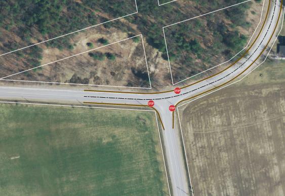
10 Intersection Improvements Road surfaces would be repaved upon completion of the installation of the watermain. Road surfaces would be repaved upon completion of the installation of the watermain. Watermain looping would be completed without intersection improvements Signalization All Way Stop Do Nothing Realignment of Veterans Way and Klondike Park Road shifted to the south within the existing road allowance to soften curve All (Three) Way Stop Control added to intersection Realignment Road surfaces would be repaved upon completion of the installation of the watermain. Realignment of Veterans Way and Klondike Park Road shifted to the south within the existing road allowance to soften curve Signalized intersection Realignment of Veterans Way and Klondike Park Road shifted to the south within the existing road allowance to soften curve Roundabout Realignment and reconfigure intersection to provide straight through traffic for Klondike Park greater traffic volume. Stop Sign added to Veterans Way at this intersection Potential for future dedicated right turn lane channelization for southbound traffic Single lane roundabout on new alignment southeast of current intersection 10
11 Existing Financial Environment Preliminary Cost Estimate Road Improvements Do Nothing Reduce Posted Speed Realignment of Curves $0 $10,000 $1,800,000 Intersection Improvements Do Nothing All Way Stop Signalization Realignment Roundabout $0 $7,500 $200,000 $200,000 $800,000 11
12 Evaluation of Alternatives Road Improvements ORDER OF PREFERENCE A NATURAL ENVIRONMENT Do Nothing Reduce Posted Speed Realignment of Curves Most Terrestrial Vegetation Preferred Moderately Preferred Surface Water and Aquatic Habitat Somewhat Preferred Impact to Provincial Park Lands Minorly Preferred Potential Impact to Wildlife and Habitat SUMMARY NATURAL ENVIRONMENT Least Preferred B SOCIO-CULTURAL ENVIRONMENT Do Nothing Reduce Posted Speed Realignment of Curves Conformity to Municipal Land Use, Policies and Planning Heritage Resources (archaeological features, built heritage, and cultural heritage landscapes) Nuisance Impacts (noise, traffic, aesthetics, disruption during construction) Land Acquisition Requirements Pedestrian Safety Cyclist Safety Motorist Safety Visibility SUMMARY SOCIO-CULTURAL ENVIRONMENT CRITERIA FOR EVALUATING ALTERNATIVES C FINANCIAL FACTORS Do Nothing Reduce Posted Speed Realignment of Curves Estimated Capital Costs Estimated Operation and Maintenance Cost Property Acquisition Cost SUMMARY FINANCIAL FACTORS D TECHNICAL FACTORS Do Nothing Reduce Posted Speed Realignment of Curves Addresses traffic control and operation requirements (Level of service, delay, queues) Traffic Capacity Improves road geometrics to minimum municipal standards Improves sight distances SUMMARY TECHNICAL FACTORS E PROBLEM STATEMENT Do Nothing Reduce Posted Speed Realignment of Curves Addresses Problem Statement No Yes Yes SUMMARY PROBLEM STATEMENT Not Preferred Preferred Preferred Do Nothing Reduce Posted Speed Realignment of Curves OVERALL SUMMARY Not Preferred Not Preferred Preferred 12
13 Evaluation of Alternatives Intersection Improvements ORDER OF PREFERENCE A NATURAL ENVIRONMENT Do Nothing All-Way Stop Signalization Realignment Roundabout Most Preferred Terrestrial Vegetation Moderately Preferred Surface Water and Aquatic Habitat Somewhat Preferred Impact to Provincial Park Lands Minorly Preferred Potential Impact to Wildlife and Habitat Least Preferred Impact to Climate Change SUMMARY NATURAL ENVIRONMENT B SOCIO-CULTURAL ENVIRONMENT Do Nothing All-Way Stop Signalization Realignment Roundabout Conformity to Municipal Land Use, Policies and Planning Heritage Resources (archaeological features, built heritage, and cultural heritage landscapes) Nuisance Impacts (noise, traffic, aesthetics, disruption during construction) Land Acquisition Requirements Pedestrian Safety Cyclist Safety Motorist Safety Visibility SUMMARY SOCIO-CULTURAL ENVIRONMENT C FINANCIAL FACTORS Do Nothing All-Way Stop Signalization Realignment Roundabout Estimated Capital Costs Estimated Operation and Maintenance Cost Property Acquisition Cost SUMMARY FINANCIAL FACTORS D TECHNICAL FACTORS Do Nothing All-Way Stop Signalization Realignment Roundabout Addresses current and short-term traffic control and operation requirements (Level of service, delay, queues) Ability to accommodate potential future traffic increases Aligns intersection layout to suit heaviest traffic movements and improves road network continuity Addresses technical safety concerns associated with improved sight distances and turning movements Improves intersection geometrics SUMMARY TECHNICAL FACTORS E PROBLEM STATEMENT Do Nothing All-Way Stop Signalization Realignment Roundabout Addresses Problem Statement No Yes Yes Yes Yes SUMMARY PROBLEM STATEMENT Not Preferred Preferred Preferred Preferred Preferred Do Nothing All-Way Stop Signalization Realignment Roundabout OVERALL SUMMARY Not Preferred Not Preferred Not Preferred Preferred Not Preferred 13
14 Preliminary Preferred Solution Intersection Improvements Realignment Road Improvements Realignment of Curves Wasaga Beach Provincial Park Realign and reconfigure intersection to provide straight through traffic for Klondike Park Road Stop sign to Veterans Way, potential for future dedicated right turn lane channelization for southbound traffic Alignment of Veterans Way curves would be softened. Includes land exchange with Wasaga Beach Provincial Park for lands outside the existing road allowance Alignment of Klondike Park Road would be adjusted within the existing road allowance 14
15 Potential Impacts and Mitigation Potential Impact Mitigation Surface water, wetland and groundwater quality from sedimentation or spills during construction The footprint of the disturbed area to be minimized as much as possible. Develop an Erosion and Sediment Control Plan, Spill Prevention and Contingency Plan for construction and operational phases of the project, including training for on-site workers Equipment fueling and maintenance completed off-site. Archaeological, cultural heritage impacts Prepare a geotechnical investigation and report, as part of the detailed design to outline groundwater conditions at the site and provide recommendations for dewatering and MOECC permit requirements. Complete a Stage 2 archaeological assessment for areas of potential earthworks within Study Area to determine if there are any archaeological resources. No impacts to cultural heritage are anticipated. Potential safety hazard from construction activities The contactor will be required to implement a Health and Safety Plan (OHSA 1990). 15
16 Potential Impacts and Mitigation Potential Impact Loss of vegetation/habitat loss, impact to species at risk Mitigation Limiting the extent of construction footprint limits as much as possible. Stabilize and re-vegetate disturbed areas and restore to a pre-disturbed state where feasible. Avoid Impacts to rare plant communities (Tallgrass Prairie/ Cultural Meadow) where possible. Implement protective measures (e.g., silt fence) to prevent access, stockpile and storage within the prairie communities Avoid the removal of low potential candidate bat maternity roosting trees where possible. Complete removals, where necessary, outside of the active bat maternity season. Develop an erosion and sediment control plan Limit construction activities with the potential to destroy migratory birds nests and eggs, to the period outside of the core breeding bird season. Complete earthworks and vegetation removal activities outside of the active season for identified Special Concern and Threatened reptile species to the extent possible. Install temporary silt fence barriers at strategic locations to exclude reptiles. Wildlife crossing(s) designed for reptiles should be installed at strategic locations Should species at risk be encountered at any time during the project, the MNRF District Office shall be contacted for advice on how to proceed. Temporary nuisance noise during construction activities. Access, Increased dust in air from construction activities. Implement noise control measures, where required. Vehicles / machinery and equipment should be in good repair, equipped with emission controls, as applicable, and operated within regulatory requirements. If required, dust control measures may include the wetting of surfaces using a non-chloride based compound to protect water quality. 16
17 Next Steps Review public, stakeholder and Agency comments generated from the PIC. (please submit all comments August 12, 2016); Prepare a PIC Summary Report including comments and responses, as applicable, to be available on the Town website following the PIC comment period. Select a preferred alternative. Present the preferred alternative to Town Council for approval in Fall Those who want to be kept informed of this process will be advised when this will be considered by council; Issue Notice of Study Completion and provide Project File Report for final public review and comment Fall 2016; and Detailed Design and Construction Currently proposed for 2018 (as identified in capital budget, subject to change). Help Shape Decisions made in this Study You can provide your comments by completing a comment sheet and placing it in the comment box, or you may take it home and return it at a later date. Please submit your comments to the project contacts below by August 12, If you would like more information or if you have any questions or concerns please contact: Mr. Paul Hausler Project Manager R.J. Burnside & Associates Limited 3 Ronell Crescent Collingwood ON L9Y 4J6 Telephone: (705) Fax: (705) Paul.Hausler@rjburnside.com Mike Latimer, C.E.T. Project Coordinator Town of Wasaga Beach 30 Lewis Street WasagaBeach ON L9Z 1A1 Office: (705) ext Fax: (705) Cell: (705) m.latimer@wasagabeach.com Information will be collected in accordance with the Freedom of Information and Protection of Privacy Act. All comments will become part of the public record. 17
Public Information Centre. Welcome
 Transportation Improvements from the Beaver Creek Bridge to the Entrance of Santa s Village District of Muskoka Municipal Class Environmental Assessment Welcome Please sign in Take a comment sheet Staff
Bostwick Road. Municipal Class Environmental Assessment. Public Information Centre #2 June 14, City of London
 Bostwick Road Municipal Class Environmental Assessment Public Information Centre #2 June 14, 2017 Welcome! Welcome to the 2 nd Public Information Centre for the. Representatives from the and the consulting
Bostwick Road. Municipal Class Environmental Assessment. October 13, City of London. Bostwick Road Municipal Class Environmental Assessment
 Bostwick Road Municipal Class Environmental Assessment October 13, 2016 Welcome! Welcome to the first Public Information Centre for the Bostwick Road Municipal Class Environmental Assessment. Representatives
Commissioners Road West Realignment Environmental Assessment
 City of London Commissioners Road West Realignment Environmental Assessment Public Information Centre No. 1 March 30, 2017 Welcome to the Public Information Centre This first Public Information Centre
Vaughan Metropolitan Centre (VMC) Black Creek Renewal CLASS ENVIRONMENTAL ASSESSMENT
 Black Creek Renewal CLASS ENVIRONMENTAL ASSESSMENT") PUBLIC INFORMATION CENTRE Vaughan Metropolitan Centre (VMC) Black Creek Renewal Wednesday, May 10, 2017 6:00 p.m. to 8:00 p.m. Add photo Project Management, Environmental Assessment, Stormwater Management
PUBLIC INFORMATION CENTRE Vaughan Metropolitan Centre (VMC) Black Creek Renewal Wednesday, May 10, 2017 6:00 p.m. to 8:00 p.m. Add photo Project Management, Environmental Assessment, Stormwater Management
Second Line West Pedestrian/Cyclist Crossing of Highway 401 Class EA. Second Line West Pedestrian/Cyclist Crossing of Highway 401 Class EA
 1 1 Purpose of Public Information Centre #2 To provide interested and/or potentially affected stakeholders with an opportunity to participate in the planning and decision-making process for this Municipal
Commissioners Road West Realignment Environmental Assessment
 City of London Commissioners Road West Realignment Environmental Assessment Public Information Centre No. 2 November 29, 2017 Welcome to the Public Information Centre This 2 nd Public Information Centre
Municipal Class EA Study Public Information Centre No. 1 December 13, :00 pm 7:00 pm. Please sign in so we can keep you updated on this study
 Reconstruction of Regional Road 45 (Creek Road) Between Regional Road 27 (River Road) and Regional Road 63 (Canborough Road) in the Township of Wainfleet Municipal Class EA Study Public Information Centre
The purpose of tonight s PIC is to:
 The purpose of tonight s PIC is to: Provide an overview of the work completed to date and a summary of the Class EA process being followed; Provide a summary of public input received so far, including
Highway 427 Industrial Secondary Plan Area 47 Schedule C Class Environmental Assessment For Arterial Roadways
 Welcome to Pubic Information Centre #1 Highway 427 Industrial Secondary Plan Area 47 Schedule C Class Environmental Assessment For Arterial Roadways Welcome to Open House # 1 Tonight, we invite you to.
Heritage Road Improvements from Steeles Avenue to Rivermont Road
 The Corporation of the City of Brampton Heritage Road Improvements from Steeles Avenue to Rivermont Road Class Environmental Assessment Study (Schedule C) September 19, 2013 The Corporation of the City
WELCOME TO OPEN HOUSE TWO November 28, 2018
 Langstaff Road Weston Road to Highway 7 Class Environmental Assessment Study WELCOME TO OPEN HOUSE TWO November 28, 2018 Please sign in and join our mailing list Study Overview York Region is conducting
Public Information Centre #1
 and Highway 401 Interchange Improvements WELCOME Public Information Centre #1 Veterans Memorial Parkway Extension and Highway 401 Interchange Improvements Study May 23, 2012 4 p.m. to 7 p.m. Brief Overview
Blackfriars Bridge Municipal Class Environmental Assessment. Public Information Centre #1 November 19 th, 2014
 Blackfriars Bridge Municipal Class Environmental Assessment Public Information Centre #1 November 19 th, 2014 Why are you here tonight? To determine the future requirements of the river crossing at Blackfriars
Public Information Centre
 Public Information Centre Sunnidale Road Highway 400 Transmission i Watermain Crossing January 31, 2012 Sir Robert Barrie Room, 2 nd Floor, City Hall 4:00 pm to 7:00 pm As part of the Environmental Assessment
Burloak Drive Grade Separation
 Burloak Drive Grade Separation Transit Project Assessment Process Public Meeting #1 March 30, 2017 GO Lakeshore West Service Plan Weekday Rush Hour 15-minute, two-way service between Aldershot* and Union
North York Centre South Service Road
 North York Centre South Service Road Municipal Class Environmental Assessment Addendum Potential Changes to Doris Avenue, Bonnington Place & Tradewind Avenue Study Summary (June 11, 2015) toronto.ca/nyc-south-road.
Commissioners Road West. Municipal Class Environmental Assessment. City of London
 Commissioners Road West Municipal Class Environmental Assessment Commissioners Road West Realignment from Springbank Drive/Byron Baseline Road to Cranbrook Road ENVIRONMENTAL STUDY REPORT B000615 Commissioners
Elevated Water Storage Facility and Pumping Station Municipal Class EA for Pressure District 7: PIC # 1 Summary
 Memorandum DATE: March 14, 2018 TO: FROM: CC: OUR REF.#: SUBJECT: Winston Wang, M.A.Sc., P.Eng Project Manager, City of Hamilton Jennifer Whittard, B.E.S., PMP Shelley Kuan, Jessica Mollo WM16-0435 Elevated
Station Street/Haig Road Extension Environmental Assessment (EA)Study. Welcome
Study. Welcome") Station Street/Haig Road Extension Environmental Assessment (EA)Study Welcome Welcome to this Public Information Centre (PIC) meeting. Please record your attendance and obtain a comment sheet at the registration
Station Street/Haig Road Extension Environmental Assessment (EA)Study Welcome Welcome to this Public Information Centre (PIC) meeting. Please record your attendance and obtain a comment sheet at the registration
Public Meeting #3 May 9, 2009 MVVA Team
 Public Meeting #3 May 9, 2009 MVVA Team Welcome to the third Public Meeting for the Lower Don Lands Municipal Class Environmental Assessment (EA) Infrastructure Master Plan and Keating Channel Precinct
Purpose of Open House #3
 Public Meeting #3 May 9, 2009 MVVA Team Purpose of Open House #3 The main purpose of this Open House is to present and seek input on the: Evaluation of transportation and infrastructure design alternatives
ENBRIDGE GAS DISTRIBUTION INC. Proposed Relocation for Ninth Line, Markham and Whitchurch-Stouffville. Environmental Screening Report
 Page 1 of 18 ENBRIDGE GAS DISTRIBUTION INC. Proposed Relocation for Ninth Line, Markham and Whitchurch-Stouffville Environmental Screening Report July 2011 Page 2 of 18 Table of Contents 1.0 INTRODUCTION
FANSHAWE PARK ROAD/RICHMOND STREET INTERSECTION IMPROVEMENTS. PUBLIC INFORMATION CENTRE 2 June 16, 2016
 FANSHAWE PARK ROAD/RICHMOND STREET INTERSECTION IMPROVEMENTS Municipal Class Environmental Assessment PUBLIC INFORMATION CENTRE 2 June 16, 2016 ACCESSIBILITY Under the Accessibility Standards 2015 for
Cherry Beach Shoreline Protection Infrastructure Conceptual Design and Class EA
 Welcome Cherry Beach Shoreline Protection Infrastructure Conceptual Design and Class EA May 3, 2012 Study Area Cherry Beach neighbourhood is located in lower Stoney Creek on Lake Ontario, east of Millen
Western Road/Wharncliffe Road North Widening from Platts Lane to Oxford Street. Municipal Class Environmental Assessment Public Information Centre #1
 Western Road/Wharncliffe Road North Widening from Platts Lane to Oxford Street Municipal Class Environmental Assessment Public Information Centre #1 June 11, 2014 Welcome Welcome to the first Public Information
ONLINE PUBLIC INFORMATION CENTRE
 ONLINE PUBLIC INFORMATION CENTRE County Road 17 Bridge Replacements Detail Design and Environmental Assessment GWP 4203-15-00 The Ministry of Transportation Ontario (MTO) has retained CH2M Hill and Dillon
Portage Parkway Environmental Assessment Public Information Centre No. 1
 City of Vaughan Portage Parkway Environmental Assessment Public Information Centre No. 1 November 25, 2015 Welcome to the Public Information Centre This first Public Information Centre (PIC) introduces
Appendix M4 - Part 1. Public Information Centre Summary Report. Appendix M4
 Appendix M4 - Part 1 Public Information Centre Summary Report Appendix M4 Public Information Centre Summary Report Sheridan Park Drive Municipal Class Environmental Assessment City of Mississauga R.J.
McKay Road Interchange and Salem / Lockhart Crossing
 McKay Road Interchange and Salem / Lockhart Crossing The McKay Road Interchange Class EA has two components: 1. A new MacKay Road Interchange at Highway 400; and 2. A new bridge crossing of Highway 400
Improvements Municipal Class Environmental Assessment. Public Information Centre #1 June 11, 2015
 Western Road & Sarnia Road/Philip Aziz Avenue Improvements Municipal Class Environmental Assessment Public Information Centre #1 June 11, 2015 1. Welcome We re hosting this Public Information Centre (PIC)
Public Information Centre No. 1 King-Vaughan Road Bridge Replacement Municipal Class Environmental Assessment City of Vaughan
 Public Information Centre No. 1 King-Vaughan Road Bridge Replacement Municipal Class Environmental Assessment City of Vaughan Date: April 7, 2016 Location: Al Palladini Community Centre, Meeting Room #1
Mavis Road Class Environmental Assessment
 Mavis Road Class Environmental Assessment Public Information Centre #2 Wednesday November 9, 2016 6:00 to 8:00 p.m. Please sign in and complete a comment sheet Review the displays on your own or join in
Meeting Agenda. City of Guelph. River Systems Advisory Committee. Agenda Items. Item 1, 2 and 3. Item 4 Ward to Downtown Pedestrian Bridge
 Meeting Agenda City of Guelph River Systems Advisory Committee September 19, 2018 City Hall, Meeting Room B From 4:00 to 6:00 p.m. Meeting Chair: Mariette Pushkar Agenda Items Welcome to all Item 1, 2
City of Cornwall Municipal Class Environmental Assessment. Proposed Improvement and Extension of Lemay Street
 Welcome City of Cornwall Municipal Class Environmental Assessment Proposed Improvement and Extension of Lemay Street Redevelopment and Design of the Municipal Works Yard Public Information Centre #1 Thursday,
Baby Point Wastewater Pumping Station Forcemain Class Environmental Assessment Study
 Baby Point Wastewater Pumping Station Forcemain Class Environmental Assessment Study Public Drop-in Event 1 Thursday, October 12, 2017 6:00 p.m. to 8:00 p.m. Humbercrest United Church Welcome Welcome to
Introduction. Public Information Package. Project website. Overview. Class Environmental Assessment Process
 1 Introduction Public Information Package Baseline Road Extension between Lambs Road and Bennett Road, Bowmanville Schedule B Municipal Class Environmental Assessment November 6, 2017 Overview The purpose
Services Department B September 10, 2007
 Report To: Development Services Committee Item: Date of Report: DS-07-246 September 5, 2007 From: Commissioner, Development File: Date of Meeting: Services Department B7200-0001 September 10, 2007 Subject:
St. Clair Avenue West Area Transportation Master Plan
 1 (Between Keele Street and Old Weston Road) Public Information Centre 1 December 2, 2015 2 Welcome Welcome to the first Public Information Centre for the St. Clair Avenue West Area. The panels will present
Lower Don River West Remedial Flood Protection Project TABLE OF CONTENTS. Page. Executive Summary
 TABLE OF CONTENTS Page Executive Summary 1.0 INTRODUCTION...1-1 1.1 Purpose of the Undertaking...1-1 1.2 Study Area Description...1-1 1.3 Description of the Undertaking...1-1 1.4 Rationale for the Undertaking...1-2
Public Information Centre # 2 Coronation Park Drainage Improvements Town of Oakville Municipal Class Environmental Assessment
 November 26, 2014 Public Information Centre # 2 Coronation Park Drainage Improvements Town of Oakville Municipal Class Environmental Assessment Study Area & Drainage System Legend Coronation Project Park
8 Oak Street - Official Plan and Zoning By-law Amendment Application - Preliminary Report
 STAFF REPORT ACTION REQUIRED 8 Oak Street - Official Plan and Zoning By-law Amendment Application - Preliminary Report Date: March 17, 2014 To: From: Wards: Reference Number: Planning and Growth Management
City of Toronto. Emery Village Transportation Master Plan
 City of Toronto Emery Village Transportation Master Plan May 2009 Emery Village Transportation Master Plan Toronto, ON May 2009 Consulting Inc. 100 York Blvd., Suite 300 Richmond Hill, ON L4B 1J8 Tel:
Ashbridges Bay TTC Maintenance and Storage Facility
 Ashbridges Bay TTC Maintenance and Storage Facility September 8, 2010 Presented to Government Review Team 1 Presentation Overview Overview of the Project Status of Transit Project Assessment Process Potential
Adelaide Street / Canadian Pacific Railway (CPR) Grade Separation. Public Information Centre #1
 Grade Separation. Public Information Centre #1") 1 Adelaide Street / Canadian Pacific Railway (CPR) Why Are We Here? 2 The purpose of Public Information Centre (PIC) #1 is to: Introduce the study Provide the study background and context Identify the
1 Adelaide Street / Canadian Pacific Railway (CPR) Why Are We Here? 2 The purpose of Public Information Centre (PIC) #1 is to: Introduce the study Provide the study background and context Identify the
NORTHEAST RIVER CROSSING FUNCTIONAL PLANNING STUDY
 WELCOME Northeast River Crossing Functional Planning Study Phase 2 Public Meeting 4 to 8 PM Informal drop-in format and discussion tables Meeting Purpose Introduce the Northeast River Crossing Functional
GLEN ROAD PEDESTRIAN BRIDGE ENVIRONMENTAL ASSESSMENT STUDY PUBLIC INFORMATION CENTRE #2 OCTOBER 24, 2017
 GLEN ROAD PEDESTRIAN BRIDGE ENVIRONMENTAL ASSESSMENT STUDY PUBLIC INFORMATION CENTRE #2 OCTOBER 24, 2017 Glen Road Pedestrian Bridge Class Environmental Assessment 1 WELCOME! Welcome to the second Public
Master Environmental Servicing Plan & Secondary Plan
 East Side Lands Stage 2 1 Master Environmental Servicing Plan & Secondary Plan Public Information Centre #1 June 16, 2016 Welcome! Today s Agenda Please sign in at the front desk. 5:30 pm 6:30 pm: Open
The Illinois Department of Transportation and Lake County Division of Transportation. Route 173, including the Millburn Bypass
 The Illinois Department of Transportation and Lake County Division of Transportation welcome you to this Public Hearing for U.S. Route 45 from Illinois Route 132 to Illinois Route 173, including the Millburn
Planning Justification Report
 Planning Justification Report Application for Draft Plan of Subdivision, Official Plan Amendment and Zoning Bylaw Amendment for Lift of Hold Proposed Residential Development Part of Lots 34 & 35, Concession
December 11, December 10, 2015
 December 11, 2015 December 10, 2015 2 Welcome & Introductions Project Overview Discussion Questions Group Insights Key Takeaways Next Steps 3 4 5 6 7 8 9 Governed by multiple layers of policy UNESCO World
Rapid Transit Implementation Working Group September 14, 2017
 Rapid Transit Implementation Working Group September 14, 2017 BACKGROUND Council approved the Rapid Transit Master Plan and Updated Business Case on July 25, 2017. Approval of the RTMP confirmed the BRT
Bridge Type Assessment and Evaluation
 16M-01410-01 (3216026) Glen Road Pedestrian Bridge EA Study Bridge Type Assessment and Evaluation Factor Group/Criteria Alternative 1: Steel girder with two inclined steel legs Alternative 2: Steel girder
Downtown Mississauga Road Improvements Master Plan Class Environmental Assessment Environmental Study Report
 Downtown Mississauga Road Improvements Master Plan Class Environmental Assessment Environmental Study Report City of Mississauga Volume I: Main Report Downtown Mississauga Road Improvements Master Plan
WELCOME! 8 8:30 6: TH STREET IMPROVEMENTS. Open House. Presentation & Q&A
 WELCOME! 168 TH STREET IMPROVEMENTS 6:30 Open House 7 8 Presentation & Q&A 8 8:30 Open House WELCOME Todd Pfitzer City of Omaha Engineer Bob Stubbe City of Omaha Public Works Director Jon Meyer Project
TERRESTRIAL NATURAL HERITAGE SYSTEM STRATEGY APPENDIX F: MODEL POLICIES FOR THE IMPLEMENTATION OF THE TARGET TERRESTRIAL NATURAL HERITAGE SYSTEM
 TERRESTRIAL NATURAL HERITAGE SYSTEM STRATEGY APPENDIX F: MODEL POLICIES FOR THE IMPLEMENTATION OF THE TARGET TERRESTRIAL NATURAL HERITAGE SYSTEM C H A P T E R 1 M O D E L P O L I C I E S F O R I M P L
APPENDIX 1: SCOPED ENVIRONMENTAL IMPACT STATEMENT (EIS) FORM
 FORM") APPENDIX 1: SCOPED ENVIRONMENTAL IMPACT STATEMENT (EIS) FORM This form is intended for use by applicants (primarily private landowners) who need to conduct a Scoped EIS in support of minor development
APPENDIX 1: SCOPED ENVIRONMENTAL IMPACT STATEMENT (EIS) FORM This form is intended for use by applicants (primarily private landowners) who need to conduct a Scoped EIS in support of minor development
Central Lake Ontario Conservation Conservation Lands Master Plan
 Conservation Lands Master Plan Top 13 Frequently Asked Questions 1. What are conservation lands? Where are these conservation lands located in the Central Lake Ontario Conservation watershed? Conservation
Adelaide Street / Canadian Pacific Railway (CPR) Grade Separation Class Environmental Assessment. Public Information Centre 3
 Grade Separation Class Environmental Assessment. Public Information Centre 3") 1 Adelaide Street / Canadian Pacific Railway (CPR) Grade Separation Study Process and Purpose of PIC 3 2 Study Commencement February 2016 Phase 1: Problem and Opportunity Identify problems and opportunities
1 Adelaide Street / Canadian Pacific Railway (CPR) Grade Separation Study Process and Purpose of PIC 3 2 Study Commencement February 2016 Phase 1: Problem and Opportunity Identify problems and opportunities
WELCOME TO OPEN HOUSE # 3
 Bayview Avenue Class Environmental Assessment Study Steeles Avenue to Elgin Mills Road WELCOME TO OPEN HOUSE # 3 Please sign in and join our mailing list Why Are We Here Tonight? Study Process and Purpose
Toronto Complete Streets Guidelines
 Toronto Complete Streets Guidelines 108 110 7.1 Green Infrastructure Design Principles 112 7.2 Context-Sensitive Green Streets 114 7.3 Key Green Street Elements Green infrastructure refers to natural and
Better Cycling. The City will update the cycling master plan (London ON Bikes) based on the approved BRT network.
 based on the approved BRT network.") Better Cycling Dedicated bike facilities will be constructed along BRT corridors where space is available. Nearby bike routes will also be upgraded to ensure a complete network is available for cyclists.
Better Cycling Dedicated bike facilities will be constructed along BRT corridors where space is available. Nearby bike routes will also be upgraded to ensure a complete network is available for cyclists.
WILLIAM STREET STORM SEWER OUTFALL. PUBLIC INFORMATION CENTRE March 23, 2017
 WILLIAM STREET STORM SEWER OUTFALL Municipal Class Environmental Assessment PUBLIC INFORMATION CENTRE March 23, 2017 ACCESSIBILITY Under the Accessibility Standards 2015 for Customer Service Regulation
TRCA Field Staking Protocol December 2016
 Page 1 of 6 TRCA Field Staking Protocol December 2016 This Protocol describes TRCA staff s current practice for field staking the physical top of bank, the physical toe of slope, and the limit of existing
Angeline Street North Corridor
 Public Information Centre Angeline Street North Corridor Colborne Street West to Roosevelt Street Town of Lindsay Municip l Cl ss Environment l Assessment Febru ry 28 th, 2019 4:30 p.m. to 6:30 p.m. Welcome
Town of Portola Valley General Plan. Nathhorst Triangle Area Plan
 Town of Portola Valley General Plan Amended December 10, 1997 Table of Contents Introduction... 1 Planning Area... 1 Objectives... 2 Principles... 2 Standards... 4 Description... 4 Community Commercial...
THE GARDEN CITY PLAN. City of St. Catharines Official Plan. City of St. Catharines
 THE GARDEN CITY PLAN City of St. Catharines Official Plan City of St. Catharines August 2010 APPROVAL INFORMATION This Official Plan of the City of St. Catharines Planning Area, known as the Garden City
One River Environmental Assessment. Welcome!
 One River Environmental Assessment Welcome! One River Environmental Assessment Welcome to the One River Environmental Assessment Public Information Centre. Please explore each presentation area to learn
Master Plan Class Environmental Assessment for Downtown Mississauga Road Improvements
 Master Plan Class Environmental Assessment for Downtown Mississauga Road Improvements Public Information Centre # 1 Wednesday June 25, 2014 5:30 p.m. to 8:00 p.m. Mississauga Civic Centre Great Hall Welcome
SUMMARY ASSESSMENT MATRIX
 ASSESSMENT MATRIX Legend: Least Preferred Most Preferred Natural Environment Terrestrial Ecosystems Avoids regulated SAR habitat. Avoids regulated SAR habitat. Avoids creating a new crossing of the features.
CITY OF VAUGHAN EXTRACT FROM COUNCIL MEETING MINUTES OF NOVEMBER 15, 2016
 Item 11, Report No. 38, of the Committee of the Whole, which was adopted without amendment by the Council of the City of Vaughan on November 15, 2016. Regional Councillor Di Biase declared an interest
COUNCIL ATTACHMENT 2 HIGHWAY 7 CORRIDOR AND VAUGHAN NORTH-SOUTH LINK
 COUNCIL ATTACHMENT 2 HIGHWAY 7 CORRIDOR AND VAUGHAN NORTH-SOUTH LINK Welcome! The purpose today is to: Present the Study Background; Describe Alignment Alternatives Analyzed; Present the Evaluation of
Evaluation Criteria. Detailed Evaluation Criteria
 Evaluation Criteria Detailed Evaluation Criteria Community Well-being A safe and socially inclusive service that improves access to key community destinations and provides transportation choices for Calgarians.
PROJECT BACKGROUND. Preliminary Design Scope and Tasks
 PROJECT BACKGROUND Preliminary Design Scope and Tasks The purpose of this Study is the development of preliminary designs for intersection improvements for Trunk Highway (TH) 36 at the intersections of
STORM SEWER OUTFALLS AND CONNECTING OUTFALL CHANNELS. General Submission Requirements
 COMPLETE APPLICATION CHECKLIST Jan 2016 STORM SEWER OUTFALLS AND CONNECTING OUTFALL CHANNELS The following checklist has been compiled to assist the applicant in preparing their application for approval
London s Bus Rapid Transit System
 London s Bus Rapid Transit System HERITAGE WORKSHOP November 7, 2017 1 Agenda 1. Introductions 2. Overview of Transit Project Assessment Process 3. Archaeology and Heritage Approval Process 4. Role of
Decision Notice. Proposed Action
 Decision Notice Paving Weld County Road 105 USDA Forest Service Arapaho and Roosevelt National Forest and Pawnee National Grassland Pawnee National Grassland Ranger District Weld County, Colorado November
Welcome. Date: Thursday March 2, 2017 Time: 6:30 p.m. 9:00 p.m. Location: Woodview School Gym, 69 Flatt Road, Burlington Presentation Time: 7:00 p.m.
 Welcome Public Information Centre No.2 City of Burlington, City of Hamilton, Region of Halton Waterdown Road Widening Detailed Design Craven Avenue to Mountain Brow Road Date: Thursday March 2, 2017 Time:
~!VAUGHAN NOV Z November 21, Mr. Denis Kelly, Regional Clerk The Regional Municipality of York Yonge Street Newmarket, ON L3Y 6Z1
 ~!VAUGHAN NOV Z 5 2016 November 21, 2016 Mr. Denis Kelly, Regional Clerk The Regional Municipality of York 17250 Yonge Street Newmarket, ON L3Y 6Z1 Dear Mr. Kelly: RE: NEW KIRBY GO STATION IN BLOCK 27
ST. MARY S SOIL CONSERVATION DISTRICT (SMSCD) AND DPW&T CONCEPT EROSION AND SEDIMENT CONTROL AND STORMWATER MANAGEMENT GUIDELINES AND CHECKLIST
 AND DPW&T CONCEPT EROSION AND SEDIMENT CONTROL AND STORMWATER MANAGEMENT GUIDELINES AND CHECKLIST") St. Mary s Soil Conservation District 26737 Radio Station Way, Suite B Leonardtown, MD 20650 Phone: 301-475-8402 ext. 3 Fax: 301-475-8391 www.stmarysscd.com St. Mary s County Government Department of Public
St. Mary s Soil Conservation District 26737 Radio Station Way, Suite B Leonardtown, MD 20650 Phone: 301-475-8402 ext. 3 Fax: 301-475-8391 www.stmarysscd.com St. Mary s County Government Department of Public
SECTION 4(f) DE MINIMIS DOCUMENTATION
 DE MINIMIS DOCUMENTATION") SECTION 4(f) DE MINIMIS DOCUMENTATION Illinois Route 60/83 IL 176 to the intersection of IL 60 (Townline Road) Lake County P-91-084-07 Mundelein Park and Recreation District Project Limit SECTION 4(f)
SECTION 4(f) DE MINIMIS DOCUMENTATION Illinois Route 60/83 IL 176 to the intersection of IL 60 (Townline Road) Lake County P-91-084-07 Mundelein Park and Recreation District Project Limit SECTION 4(f)
PLANNING, DESIGN & DEVELOPMENT OPEN HOUSE
 PLANNING, DESIGN & DEVELOPMENT OPEN HOUSE Proposal to re-zone 34.9 hectares (86 acres) on the east side of Winston Churchill Boulevard, north of Old Pine Crest Road from Agricultural to Industrial Mineral
Dundas Place Flexible Street Public Information Centre
 WELCOME TO THE DUNDAS PLACE DESIGN REVEAL Dundas Place Flexible Street Public Information Centre November 8, 2017 This project is funded by the City of London with support from the Government of Canada
Alternative Routes. St. Vital to La Verendrye Station - Southern Loop Transmission Corridor. 20 different segments 4 segments common to all routes
 Alternative Routes St. Vital to La Verendrye Station - Southern Loop Transmission Corridor In a fixed right-of-way St. Vital to Letellier Station 20 different segments 4 segments common to all routes Goal
PARK CITY MUNICIPAL CODE TABLE OF CONTENTS TITLE 15 LAND MANAGEMENT CODE - CHAPTER 2.21
 PARK CITY MUNICIPAL CODE TABLE OF CONTENTS TITLE 15 LAND MANAGEMENT CODE - CHAPTER 2.21 TITLE 15 - LAND MANAGEMENT CODE CHAPTER 2.21 - SENSITIVE LAND OVERLAY ZONE (SLO) REGULATIONS 15-2.21-1. PURPOSE...1
Asbury Chapel Subdivision Sketch Plan
 Asbury Chapel Subdivision Sketch Plan PART 1: PROJECT SUMMARY Applicant: NVR Inc. Project Size: +/- 76.13 acres Parcel Numbers: 02101112,02116101,02116112, 02116113 Current Zoning: Transitional Residential
Essential Skills: Reading and Interpreting Maps and Plans
 Essential Skills: Reading and Interpreting Maps and Plans Prepared for: NYS Tug Hill Commission Local Government Conference March 31, 2016 Prepared by: Peter G. Vars, P.E. BME ASSOCIATES Stages of Plan
WELCOME TO THE PUBLIC INFORMATION CENTRE. Please Sign In
 WELCOME TO THE PUBLIC INFORMATION CENTRE Replacement of Oxtongue Lake Narrows Bridge & Oxtongue River Bridge, Highway 60 (G.W.P. 93-89-00 & G.W.P. 5550-04-00) Class Environmental Assessment (Group B) Please
AGENDA ITEM: IOWA. west] that were not FISCAL IMPACT. the City of Clive. STAFF REVIEW. Resolution II. Amendment PREPARED BY: REVIEWED BY:
![AGENDA ITEM: IOWA. west] that were not FISCAL IMPACT. the City of Clive. STAFF REVIEW. Resolution II. Amendment PREPARED BY: REVIEWED BY:](/thumbs/93/112428810.jpg "AGENDA ITEM: IOWA. west] that were not FISCAL IMPACT. the City of Clive. STAFF REVIEW. Resolution II. Amendment PREPARED BY: REVIEWED BY:") AGENDA ITEM: CITY OF WAUKEE, IOWA CITY COUNCIL MEETING COMMUNICATION MEETING DATE: March 7, 2016 AGENDA ITEM: Consideration of approval of a resolution approving Engineering Services Amendment No. 1 with
AGENDA ITEM: CITY OF WAUKEE, IOWA CITY COUNCIL MEETING COMMUNICATION MEETING DATE: March 7, 2016 AGENDA ITEM: Consideration of approval of a resolution approving Engineering Services Amendment No. 1 with
Recreational Pathway Crossing of Richmond Street Municipal Class Environmental Assessment. Public Information Centre #2 April 22, 2015
 Recreational Pathway Crossing of Richmond Street Municipal Class Environmental Assessment Public Information Centre #2 April 22, 2015 1. Study Process PHASE 1 PHASE 2 PHASE 3 PHASE 1 : Problem/Opportunity
ARTICLE 6: Special and Planned Development Districts
 ARTICLE 6: Special and Planned Development Districts 6-10 Traditional Neighborhood Development (TND) District 6-10.10 Purpose and Intent The Traditional Neighborhood Development (TND) District provides
Elfrida Growth Area Study
 Elfrida Growth Area Study Public Information Centre #2 December 6, 2017 6:00-8:30 pm PLANNING & ECONOMIC DEVELOPMENT DEPARTMENT Purpose of the Study The Elfrida Area has been identified as the preferred
TOWN OF WHITBY REPORT RECOMMENDATION REPORT
 TOWN OF WHITBY REPORT RECOMMENDATION REPORT REPORT TO: Council REPORT NO: PL 95-09 DATE OF MEETING: October 13, 2009 PREPARED BY: Planning/Public Works Joint Report FILE NO(S): N/A LOCATION: N/A REPORT
STREAM BUFFERS
 88-415 STREAM BUFFERS 88-415-01 PURPOSE In the Kansas City region and throughout the nation, vegetated stream buffers have been clearly shown to protect stream stability and related infrastructure, improve
CHAIR AND MEMBERS CIVIC WORKS COMMITTEE MEETING ON JUNE 19, 2018
 TO: FROM: SUBJECT: CHAIR AND MEMBERS CIVIC WORKS COMMITTEE MEETING ON JUNE 19, 2018 KELLY SCHERR, P. ENG., MBA, FEC MANAGING DIRECTOR, ENVIRONMENTAL & ENGINEERING SERVICES AND CITY ENGINEER VICTORIA BRIDGE
Westwood Shopping Center Sketch Plan, Plan # February 23, 2017 Item # 9
 Westwood Shopping Center Sketch Plan, Plan # 320170010 February 23, 2017 Item # 9 Westwood II Site 64,111 s.f. Manor Care site: vacant two story building HOC-Westwood Towers, 15 story tower To be considered
Planning and Building Inspection Department Mitigation Monitoring Reporting Plan (MMRP) Potrero Subdivision Santa Lucia Preserve
 Potrero Subdivision Santa Lucia Preserve") Planning and Building Inspection Department Mitigation Monitoring Reporting Plan (MMRP) Potrero Subdivision Santa Lucia Preserve Project Name: Potrero Area Subdivision File No: PLN010001 APNs: 239-102-001-000;
Planning and Building Inspection Department Mitigation Monitoring Reporting Plan (MMRP) Potrero Subdivision Santa Lucia Preserve Project Name: Potrero Area Subdivision File No: PLN010001 APNs: 239-102-001-000;
OP Council Resolution June 16, Planning and Development Services
 OP-08-01 Council Resolution June 16, 2008 Planning and Development Services Kingsgate Landing Outline Plan Table of Contents 1.0 Introduction 1 1.1 Purpose of Plan 1 1.2 Plan Area Location 1 1.3 Ownership
Appendix I. Checklists
 Appendix I Checklists Town of Greenwich Drainage Manual Department of Public Works - Engineering Division Town Hall - 101 Field Point Road, Greenwich, CT 06836-2540 Phone 203-622-7767 - Fax 203-622-7747
ENVIRONMENTAL ADVISORY COMMITTEE WEDNESDAY, JANUARY 11, 2017 AT 7:00 P.M. CITY HALL MEETING ROOM C MINUTES
 ENVIRONMENTAL ADVISORY COMMITTEE WEDNESDAY, JANUARY 11, 2017 AT 7:00 P.M. CITY HALL MEETING ROOM C MINUTES Present: C. Oakes (Chair) M. Wilson A. Baron A. Miller A. Singh L. Todd L. Renzetti Regrets: City: