ANALYSIS OF PROPOSALS ERIK MØLLER ARKITEKTER KANOZI ARKITEKTER LILJEWALL ARKITEKTER
|
|
|
- Reynold Fields
- 5 years ago
- Views:
Transcription

1 ANALYSIS OF PROPOSALS ARKITEKTER ARKITEKTER ARKITEKTER 1
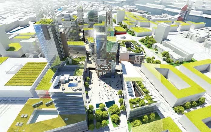
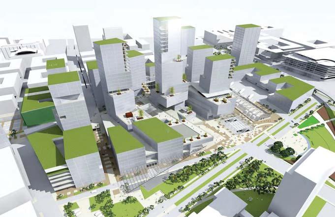
2 CRITERIA A. CONTINUITY B. EFFICIENCY C. QUALITY D. DIVERSITY E. ACCESSIBILITY How are the connections between adjacent neighborhoods and Region City? Is Gulbergvass well connected? Are there long and clear sightlines? Is the urban fabric continuous, simple and rational? Is the viaduct integrated in the urban fabric? Does it interfere with east-west relations? Does Region City become a clear and continuous connection between the river, the existing and the future neighbourhoods? Is the use of space rational? Does it emphasize the need of higher density nearby Nils Ericsonsgatan? Does the proposal fullfi ll the living space requirements for a major, central and 24-7 vibrant city centre? Is there public space linked to every central crossing? Do spaces connect visually to each other? Can we talk about a pearl-rope of open spaces? Is it a three dimensional network? Are open spaces perceived as public? Are they comfortable and attractive? Is there a wide range of uses? Is it attractive and alive during both day and night time? Will every person fi nd a different reason to go to Region City? How are pedestrian, bike and public transport networks? Is there universal accessibility? Is it easy to orientate? Are public transport nodes well connected? Do different fl ows interfere with each other? Is there clear and direct access for transport of goods? Is the viaduct a city street? Does it create anonymous or uninhabited spaces? 2


3 A. CONTINUITY Connections Urban fabric Sightlines There are strong east-west sightlines which provide good east-west relation, as well as a regular and compact urban fabric for future constructions over the railways. The connection with the river aims to be clear with the extension of Nya Göta bridge in a straight street, but it lacks a main space in the core of Region City to close the strong sightline that is now orphaned. The existing connection appears weak and the space doesn t receive and distribute the fl ow because it is very tangential. The bus station doesn t contribute to unify the sightline from Nils Ericsons corridor either. The proposal lacks information on future planning and transition between 1600 and 1800 grids. Nils Ericsons corridor, Nya Göta bridge and the main square in Region City are well connected. Also the new planning for Gullbergvass integrates the existing riverside network and the new main street of the proposal. Bergslagsgatan will become a major element so it might be interesting to defi ne its beginning. Now it is a bit diffused among a sequence of open spaces and traffi c crossings. A missing piece, or the bus station itself, could contribute to shape that anonymous corner. New development over the railways looks like an independent element, maybe too fragmented. There is also an unclear transition between 1600 and 1800 city grids, thus generating an undefi ned space that breaks the new planned urban fabric. Nils Ericsons corridor, Nya Göta bridge and the main space in Region City are quite well connected. The transition from 1800 to 1600 grid is easy and efficient and the whole new planning for Gullbergvass and over the railways works very well. Despite of the logical planning for Gulbergvass, the hinge turns into a bit of undefi ned space inside Region City. The 1800 grid extended to the new planning links this area quite well with the existing buildings by the river, but it is therefore less integrated into Nordstaden. The whole proposal seems somewhat unrelated from its western neigborhood. 3


4 B. EFFICIENCY Density Living Space The game of volumes, providing green and open spaces at various heights, allows living space to be widely developed. The increase of density towards the bus station is convenient, but we think this gradual rising of the height should be connected to a large scale space that gives meaning and articulates the busy center of the future Göteborg. The main public space in the center of Region City is directly linked with a high density area and thus this space becomes a meaningful and alive core for the city. The closest buildings to Nils Ericsonsgatan also make the best use of space increasing the density and providing a front face to the street. The higher buildings are in the eastern part and maybe some of this space and height could be better used in the desired higher density area nearby Nils Ericsons corridor, to link this skyscraper image to the business center. The tower facing Nils Ericsonsgatan increases the use of this space and provides a face for one of the main access points to Region City. Apart from that, it seems that the surroundings of the bus station have a lower density than the desirable. The main space designed for the proposal might become extremely large and out of scale. 4


5 C. QUALITY Green corridor Nils Ericsonsgatan Pearl-rope of open spaces Public perception of space Big city park for Gulbergvass There is a wide offer of green areas distributed in different levels due to the volume game proposed. However, it lacks the concept of the pearl-rope of spaces, some spatial hierarchy that generates at least one main space to connect and distribute the different fl ows of people, a meeting point linked to other minor spaces with different grades of privacy. Here we can appreciate the sequence of spaces that gradually link the green corridor in Nils Ericsonsgatan with Gullbergvass. From the main square one can be easily oriented. In our opinion the courtyards generated in the inner part of the volumes are hardly perceived as public space. Connections between different levels most frequently take place within them, so the pedestrian won t perceive a three dimensional network of public space from the outside. The main terraced space seems for us somewhat out of scale. We believe in a hierarchy and sequence of spaces as main ideas for a new city centre, so would like a sequence of different, human scaled, attractive and interconnected spaces rather than only one which is too big to be perceived as a whole. 5


6 D. DIVERSITY Mixture of uses 24H vibrant city The living space is more related to the eastern part which can be understood as an extension of the living area of Gulbergvass. 24H life in the center relies on a lot of space reserved for hotels, but it might be necessary to consider the actual needs of lodging for the future city to ensure life after offi ce hours. The higher levels have plenty of connections between buildings. Despite this, we think that most of them will be seen as private passages for workers or residents in the city, deterring the major fl ow of visitors from moving upwards. This means that business in higher fl oors have more diffi culty to succeed, thus creating levels that could be quite uninhabited. Housing and lodging could maybe be spread throughout the whole area as well. The connections between levels are random and sparse. There is not a clear three dimensional crust with links that invite visitors to use higher levels. There is not enough information concerning the distribution of living space. 6


7 D. ACCESSIBILITY Pedestrians Travellers Bikes Public transport Cars Goods There are plenty of connections in the lower commercial fl oors. Pedestrians and bikes can move safely throughout the whole area. The lack of open nodes to distribute the fl ow doesn t allow connections between levels to be easily perceived. This means that orientation is more diffi cult. The viaduct is poorly connected to the city. There are no major spaces linked to it so it is not perceived as a city street but as a traffi c road. Also the crossing on level 0 is complicated for vehicles and it might need traffi c lights, a bad solution. The viaduct is well integrated in the city and it functions as a major city street. Connections for pedestrians are easy and related to main spaces. The public and open space decreases the perception of a large traffi c road. The viaduct is not accessible for bikes, except from the vehicular point of entry. Universal accessibility is also poor, relegated to a few narrow and steep ramps. The different levels of the city are quite independent. Connections occur in the courtyards, based on the questionable idea that they are perceived as public spaces. Vehicular traffi c is widely allowed on inner city streets. Specially the main axis would gain quality if free of cars. There is no place for bikes within Region City, just around it. We think that use of bike should be promoted by making it easy to access and park as close as possible to working and leisure centers. There are some public spaces attached to the viaduct but access is tangential and from minor spaces, so we wonder how attractive and alive it would be. The split ramp lacks visibility and the traffi c diagram shows that the main branch is designated to cars (orange) instead of buses (green). Anyway we now think it is more effi cient and logical to have just one ramp. Also the fl ow diagram for goods (purple) doesn t seem very realistic with a 180 degrees turning point for trucks. 7
8 SUMMARY REIULF RAMSTAD ARKITEKTER North. Nya Göta Connections East. Gullbergvass West. Kanaltorsgatan / Spannmålsgatan South. New planning over railways Urban Fabric Long sightlines High density around Nils Ericsonsgatan Living space Green corridor Nils Ericsonsgatan Pearl-rope of open spaces Public perception of space Big city park for Gulbergvass Mixture of uses 24H vibrant city (3D network, inviting to higher levels) The viaduct is one of the most delicate parts of the planning. We think that just one ramp is much better than splitting it for different flows as proposed earlier, to create a better use of the space and avoiding a complex high crossing. Viaduct connection Plus Average Minus 8
9 9
REGION CITY ASSESSMENT OF THE STRENGTHS AND WEAKNESSES IN THE OTHER THREE PROJECTS
 REGION CITY ASSESSMENT OF THE STRENGTHS AND WEAKNESSES IN THE OTHER THREE PROJECTS 1 REIULF RAMSTAD SIGHT LINES AND DIRECTIONS IN THE PLAN To integrate an entirely new neighborhood in an existing urban
4.0 URBAN DESIGN FRAMEWORK. The vision for the future development of the plan area is to:
 4.0 The vision for the future development of the plan area is to: Create a new neighbourhood that focuses on the highly valued natural and aesthetic features of the lands and provides good quality homes,
Public Consultation Summary: Lakeview Place Making Workshop January 30, 2008.
 Page 1 of 11 Public Consultation Summary: Lakeview Place Making Workshop January 30, 2008. 1.0 Introduction: On January 30, 2008 the City of Mississauga, in conjunction with the consulting team of Brook
The River Hub: NEW BUILDINGS
 Summary The River Hub includes 6 municipalities that all boarder the Fraser River. Combined, they are expected to double in population over the next 50 years. To accommodate this new population, 138,831
University of Minnesota. MINNEAPOLIS CAMPUS DEVELOPMENT FRAMEWORK February 11, 2016
 MINNEAPOLIS CAMPUS DEVELOPMENT FRAMEWORK DEVELOPMENT FRAMEWORK of use shape the campus today and may inform the future. Form, meaning how the shape, size, orientation, and arrangement of buildings, spaces,
FUNDAMENTAL BUILDING BLOCKS
 FUNDAMENTAL BUILDING BLOCKS THE WEB OF GIBSONS - EXISTING Lacks Community Structure and Support Circulation, surface water flow and buildings are disjointed from the community Social neighbourhoods are
URBAN DESIGN BRIEF New Street Burlington, ON
 3225-3237 New Street Burlington, ON MARCH 2017 Prepared for: Royal Living Development Group Inc. Prepared by: adesso design inc. 218 Locke Street South, 2nd Floor Hamilton, ON L8P 4B4 t. 905.526.8876 3225-3237
Revitalizing Urban Main Streets
 MIT OpenCourseWare http://ocw.mit.edu Spring 2009 For information about citing these materials or our Terms of Use, visit: http://ocw.mit.edu/terms. Team 1: Traffic/Pedestrian Activity/Public Transportation
Figure 3-1: Public Realm Plan
 3 Public Realm Figure 3-1: Public Realm Plan 3.1 Public Realm Concept The public realm concept for the Little Mountain site integrates a clear and accessible movement network with public spaces for social
Greater Langley: NEW BUILDINGS
 District Scale Overview The Liveable Region Strategic Plan (LRSP) identifies four main growth strategies: Protect the green zone; build complete communities; achieve a compact metropolitan area and increase
TRAFALGAR ROAD
 158-2192 TRAFALGAR ROAD URBAN DESIGN BRIEF PREPARED BY KLM PLANNING PARTNERS INC. FOR DUNPAR DEVELOPMENTS INC. TOWN OF OAKVILLE JUNE 2012 TABLE OF CONTENTS 1 INTRODUCTION 1.1 Project Description...1 1.1.1
Workshop 3. City of Burlington Waterfront Hotel Planning Study. September 14, The Planning Partnership
 Workshop 3 City of Burlington Waterfront Hotel Planning Study September 14, 2017 The Planning Partnership The Waterfront Hotel Planning Study 01 The Brant & Lakeshore Planning Study will establish a Strategic
Colchester Northern Gateway Master Plan Vision Review Draft. July 2016
 Colchester Northern Gateway Master Plan Vision Review Draft July 2016 Contents Introduction 4 Context 8 Purpose of the Report 8 Strategic Position 9 Overview of the Process 11 2012 Master Plan Vision 12
IMAGE AND DESIGN. Guiding Principles
 Building competitive cities means building more than just places to live and work. It s about creating places that inspire, places with character, places that draw people with a personal sense of identity.
THE NEIGHBORHOOD TODAY
 THE NEIGHBORHOOD TODAY CORE AREA VISION How are we Good Urbanism A Site s DNA thinking about Elements of great Unique elements urban communities embedded in a place the site and design? ELEMENTS LIKE:
City of Farmington. Downtown Plan. Amendment to the 1998 Master Plan Adopted October 11, 2004
 City of Farmington Amendment to the 1998 Master Plan Adopted October 11, 2004 Introduction Planning Background 1 Scope and Components of the Plan Amendment 2 Concept Introduction 3 Plan Concepts 3 Conceptual
REPORT BACK BROADSHEET 3 May 2016
 Paddington Place REPORT BACK BROADSHEET May 06 Architects and planners should work with the community first and then thinking about developers profits second. - Quote from participant at Paddington Place
Negative Space Positive Environment
 Negative Space Positive Environment Mapping Opportunities for Urban Resilience M. Kowalik Dr. M. Guaralda Queensland University of Technology Outline Background Understanding Cities Approaches to Urban
Jim Harkins DUNDEE WATER FRONT CIRCULATOR DUNDEE WATER FRONT CIRCULATOR. Specialists in Affordable & Sustainable Tramways. A short presentation by
 DUNDEE WATER FRONT CIRCULATOR DUNDEE WATER FRONT CIRCULATOR A short presentation by Jim Harkins Light Rail (UK) Specialists in Affordable & Sustainable Tramways www.lightrailuk.com E-mail Lightrailuk@aol.com
PUBLIC OPEN HOUSE SEPTEMBER 8 TH, 2010 CITY OF LETHBRIDGE DEVELOPMENT SERVICES
 PUBLIC OPEN HOUSE SEPTEMBER 8 TH, 2010 CITY OF LETHBRIDGE DEVELOPMENT SERVICES INTRODUCTION Why is the City creating the West Lethbridge Employment Centre Area Structure Plan? West Lethbridge Urbanization
Lincoln Multi-Modal Center
 University of Nebraska - Lincoln DigitalCommons@University of Nebraska - Lincoln Theses from the Architecture Program Architecture Program May 2006 Lincoln Multi-Modal Center Jeffrey Bayer Follow this
Welcome to our public exhibition
 About Our Scheme Welcome to our public exhibition This exhibition gives you the chance to view and comment upon our emerging proposals for a new residential development of 68 new homes on the site of the
Urban Design Brief Proposed Residential Development 5219 Upper Middle Road City of Burlington
 Urban Design Brief Proposed Residential Development 5219 Upper Middle Road City of Burlington Prepared by Weston Consulting Prepared for BLOOMFIELD DEVELOPMENT INC. Date: March 2017 Table of Contents 1.
K. SMART ASSOCIATES LIMITED
 Planning Justification Report Zoning By-Law Amendment 185 King Street North Waterloo, Ontario April 7th, 2017 Project Reference Number 16-245 K. SMART ASSOCIATES LIMITED CONSULTING ENGINEERS AND PLANNERS
TOTAL SYSTEM EFFICIENCY: CONDENSING BOILER SYSTEM MYTH BUSTING. David Grassl PE Mechanical Engineer Principal
 TOTAL SYSTEM EFFICIENCY: CONDENSING BOILER SYSTEM MYTH BUSTING David Grassl PE Mechanical Engineer Principal There are many reasons why engineers have been led to believe that condensing boilers do not
12600 S Existing Conditions
 STUDY AREA BOUNDARY Study Area Boundary Study Area Context The District Riverton Meadows Vista Station Mountain View Village Market Center 2 Mile Radius 12600 S Existing Conditions 12600 S is a river of
Creating an integrated waterfront. Recommendations
 Creating an integrated waterfront Recommendations Railway Square Post Office + Shell Station Post Office Square Civic Square Ilot Green Wakefield St Wakefield St (Tory Cars) Wakefield St (New World Supermarket)
Urban Design Principles
 Urban Design Principles 3.0 Harbouside Waterfront Rezoning Submission - November 2012 3.1 Urban Design Principles Twelve distinct design principles have been identifi ed for the Harbourside Waterfront
Section Three, Appendix 16C Medium Density Housing, Design Assessment Criteria (Residential 8A zone)
") APPENDIX 16C MEDIUM DENSITY HOUSING, DESIGN ASSESSMENT CRITERIA (RESIDENTIAL 8A ZONE) PURPOSE OF APPENDIX 16C (RESIDENTIAL 8A ZONE) In the Residential 8A Zone the following are defined as restricted discretionary
APPENDIX 16C MEDIUM DENSITY HOUSING, DESIGN ASSESSMENT CRITERIA (RESIDENTIAL 8A ZONE) PURPOSE OF APPENDIX 16C (RESIDENTIAL 8A ZONE) In the Residential 8A Zone the following are defined as restricted discretionary
Page 1 of 19 URBAN DESIGN FRAMEWORK FOR BOLTON STREET WATERFORD
 Page 1 of 19 URBAN DESIGN FRAMEWORK FOR BOLTON STREET WATERFORD 1.0 Introduction: The relocation of the City Council stores and depot from Bolton Street creates an exciting opportunity for development
BROOKHILL NEIGHBORHOOD MODEL ZONING MAP AMENDMENT PREFACE TO APPLICATION
 BROOKHILL NEIGHBORHOOD MODEL ZONING MAP AMENDMENT PREFACE TO APPLICATION June 15, 2015 Revised: August 1, 2016 I. VISION Brookhill is a proposed community based upon the principles of Albemarle County
Laird in Focus Community Information Session
 Laird in Focus Community Information Session Tuesday, December 5, 2017 St. Anslem Catholic School, 182 Bessborough Drive Session 1: 5:30 pm - Presentation and Question and Answer Period 6:15 pm - Breakout
TEAM INPUT SUMMARY. Postcard Image?
 DOWNTOWN MAULDIN TEAM PUBLIC INPUT TEAM INPUT SUMMARY Postcard Image? A nice neighborhood The main city center with government buildings Mauldin entry sign, high school, Cultural Center, Sunset Park, Hall
Residential Cluster, Ahmedabad: Housing based on the traditional Pols
 Residential Cluster, Ahmedabad: Housing based on the traditional Pols KANIKA AGARWAL 1 1 M. Arch. Sustainable Environmental Design (E+E) Architectural Association School of Architecture, London, United
One said, without a clear understanding of what will be annexed, this is an exercise in futility.
 Stakeholder Focus Groups: Summary of Meetings Stakeholder Focus Group meetings were held on at the Pinellas County Planning Department conference room. Focus Group meetings will be held during each of
Mississippi Drive Corridor Revitalization. A DestinationTransportation Project...
 Mississippi Drive Corridor Revitalization A DestinationTransportation Project... Mississippi Drive Corridor Revitalization Welcome! Tonight s Agenda: Further define the Scope of the Project Discuss the
Urban Design Manual PLANNING AROUND RAPID TRANSIT STATIONS (PARTS) Introduction. Station Study Areas
 Introduction. Station Study Areas") 111111 PLANNING AROUND RAPID TRANSIT STATIONS (PARTS) Introduction The ION rapid transit system will link Waterloo, Kitchener and Cambridge through a central transit corridor (CTC). There are a number
111111 PLANNING AROUND RAPID TRANSIT STATIONS (PARTS) Introduction The ION rapid transit system will link Waterloo, Kitchener and Cambridge through a central transit corridor (CTC). There are a number
DENVER DESIGN DISTRICT GDP
 DENVER DESIGN DISTRICT GDP Urban Design Standards and Guidelines November 17, 2008 Amended February 3, 2016 City and County of Denver CF Property Management, Inc. C/O Denver Design District - Starboard
Environmental Activity Nodes
 Chinese here 环保 Design Eco-Programming and Eco-Programming & Design Environmental Activity Nodes ENVIRONMENTAL EDUCATION WATER CLEANSING +URBAN DESIGN MARKETPLACE FOR LOCAL PRODUCTS Case Studies Xochimilco
CHONGMING ISLAND SHANGHAI CENTRAL CITY
 Chongming Island CHONGMING ISLAND SHANGHAI CENTRAL CITY Chongming Island Shanghai, China THE VISION: A GREEN ISLAND Chongming Island benefits from a magnificent setting, adjacency to the vibrant center
ELMVALE ACRES SHOPPING CENTRE MASTER PLAN
 ELMVALE ACRES SHOPPING CENTRE MASTER PLAN Contents 1.0 INTRODUCTION... 2 2.0 LOCATION... 2 3.0 EXISTING CONTEXT... 2 4.0 VISION & GUIDING PRINCIPLES... 2 5.0 LAND USE AND BUILT FORM... 4 5.1 St. Laurent
Chapter 2: OUTLINE PLANNING APPLICATION PROPOSALS. A New Garden Neighbourhood Matford Barton 17
 Chapter 2: OUTLINE PLANNING APPLICATION PROPOSALS A New Garden Neighbourhood Matford Barton 17 2.1. SUMMARY AND STATUS OF THE PROPOSALS 2.1.1. The parameter plans and associated wording in this chapter
Arterial Mainstreets ottawa.ca
 Urban Design Guidelines for Development along Arterial Mainstreets ottawa.ca Ce document est disponible en français sur ottawa.ca. This document is available in French on ottawa.ca. Approved by City Council
 Health Sciences City The available land area, although limited, combined with the unique partnership between the primary institutions and the supporting partnerships of the development interests within
appendix and street interface guidelines
 appendix five: building and street interface guidelines appendix 5 building and street interface guidelines BOULEVARDS Boulevards are generally characterized by higher levels of traffic movement at higher
The urban block as a potential for sustainable urban design
 The Sustainable City X 69 The urban block as a potential for sustainable urban design M. Oikonomou Department of Urban Planning and Regional Development, Aristotle University of Thessaloniki, Greece Abstract
Seneca Meadows. Block 4 Locate office, technology, and medical development adjacent to I Screen views of garage structures from I-270.
 Seneca Meadows Seneca Meadows has an industrial park in its southern end and a mixed-use employment area planned for the north end. The district benefits from extensive I-270 visibility, stream valley
Land Use Amendment in Southwood (Ward 11) at and Elbow Drive SW, LOC
 at and Elbow Drive SW, LOC") 2018 November 15 Page 1 of 10 EXECUTIVE SUMMARY This land use amendment application was submitted by Rick Balbi Architect on 2017 August 31 on behalf of Sable Developments Ltd, and with authorization from
2018 November 15 Page 1 of 10 EXECUTIVE SUMMARY This land use amendment application was submitted by Rick Balbi Architect on 2017 August 31 on behalf of Sable Developments Ltd, and with authorization from
Design Guidelines. Roosevelt. Mike Podowski DPD Design Guidelines Ordinance ATT 13 August 13, 2012 Version #1
 Roosevelt Design Guidelines The Roosevelt Neighborhood Design Guidelines apply within the Neighborhood Boundary. Map 1 2 Map 2 3 Map 3 4 CS1 Natural Systems and Site Features Citywide Guideline: Use natural
Urban Design Brief December 23, 2015 Southside Construction Group Official Plan & Zoning By-Law Amendment
 Urban Design Brief Proposed Official Plan & Zoning By-Law Amendment 3244, 3263 and 3274 Wonderland Road South Southside Group December 23, 2015 TABLE OF CONTENTS Page No. INTRODUCTION... 1 SECTION 1 LAND
École secondaire catholique Paul-Desmarais DOME 5315 ABBOTT STREET EAST OTTAWA, ON SITE PLAN CONTROL APPLICATION PLANNING RATIONALE
 SITE PLAN CONTROL APPLICATION PLANNING RATIONALE D E S I G N S T A T E M E N T F E B U A R Y 2018 PURPOSE Conseil des écoles catholique du Centre-Est (CECCE) has retained Edward J. Cuhaci and Associates
WEST LOOP DESIGN GUIDELINES CHECKLIST
 WEST LOOP DESIGN GUIDELINES CHECKLIST Section 1.0 General Strategies 1.1 DESIGN EXCELLENCE: ENCOURAGE HIGH QUALITY AND INNOVATIVE DESIGN OF NEW BUILDINGS WITHIN THE WEST LOOP WITHOUT BEING PRESCRIPTIVE
Appendix C: Interim Mixed-Use Evaluation Criteria
 Appendix C: Interim Mixed-Use Evaluation Criteria C-1 Appendix C: Interim Mixed-Use Evaluation Criteria PURPOSE: The implementation of numerous policies contained within the Master Plan hinges on the creation
heuston gateway: sections heuston gateway: regeneration strategy and development framework plan
 B B1 A B1 B C A heuston gateway: sections B B1 C 117 4.3.3 Zoning The station is the central hub of the area and this function must be preserved and developed. However large areas of the Heuston Station
ENJOY THE FLEXIBILITY of your new space. A great opportunity to expand your living
 MYRIAD SUNROOMS by EXPLORE THE BENEFITS of a Myriad Sunroom and revel in the amazing benefi ts of a beautifully designed, energy effi cient three or all season Myriad Sunroom by NT Window. In many cases,
Hilltop Town Garden City
 Page 1 of 14 4.1 CITY PLANNING PRECEDENTS Oakridge is a Hybrid of the positive aspects of these urban design strategies that integrate nature within the city: Hilltop Town Garden City Using topography
LEGEND. vehicular circulation. pedestrian circulation. bus stop. residential use. civic use. residential/mixed use. commercial use.
 LEGEND vehicular circulation pedestrian circulation bus stop residential use civic use residential/mixed use commercial use on-street parking CIRCULATION ANALYSIS LEGEND enclosed focal point view open
GUIDELINES. Transit Oriented Development. Approved by Edmonton City Council on February 15, 2012 in tandem with City Policy C565
 Transit Oriented Development GUIDELINES Prepared by the City of Edmonton Sustainable Development and Transportation Services Departments Approved by Edmonton City Council on February 15, 2012 in tandem
Trafalgar Road Corridor Planning Study Open House
 Trafalgar Road Corridor Planning Study Open House June 24, 2013 6:30-8:30 p.m. Oakville & Trafalgar Rooms Overview The Livable Oakville Plan identifies the lands along Trafalgar Road, between the QEW and
Portland was a beautiful city, but in the 1960s and 1970s, its population grew very fast.
 4 Portland, Oregon, 1973 After reading Section 4, identify three challenges facing Portland in 1973. Record them in the boxes below. Draw a line from each box to the part of the city most affected by that
TAKE ACTION #1 - STREET: THE PLACE GAME AND THE PLINTH GAME
 TAKE ACTION #1 - STREET: THE PLACE GAME AND THE PLINTH GAME Hans Karssenberg (public developer) Transforming a street, a district, an inner city, or creating a new district with a great city at eye level
Planning Board Briefing
 Planning Board Briefing Why Now? The Sector Plan Implementation Chapter States: Before Stage 1 begins, the following must occur: Approval of the Sectional Map Amendment. Approval of the Greater Lyttonsville
1.3 TRANSIT VISION 2040 FROM VISION TO ACTION THEME 1: PUTTING TRANSIT AT THE CENTRE OF COMMUNITIES. Fully integrate transit with community planning
 TRANSIT VISION 2040 FROM VISION TO ACTION TRANSIT VISION 2040 defines a future in which public transit maximizes its contribution to quality of life with benefits that support a vibrant and equitable society,
KANATA CENTRUM 255 KANATA AVENUE OFFICIAL PLAN AMENDMENT ZONING BY-LAW AMENDMENT
 KANATA CENTRUM 255 KANATA AVENUE OFFICIAL PLAN AMENDMENT ZONING BY-LAW AMENDMENT JUNE 2015 PREPARED BY: FOTENN Consultants Inc. 223 Mcleod Street Ottawa, ON K2P OZ8 (613) 730-5709 PREPARED FOR: Kanata
MOUNT AVENUE MASTERPLAN WORKING DRAFT NOVEMBER 2006
 MOUNT AVENUE MASTERPLAN WORKING DRAFT NOVEMBER 2006 1 1. OVERALL MASTERPLAN IDENTITY: Dun Dealgan motte and bailey The Dun Dealgan motte and bailey, a national monument, is located to the north east of
Walnut Creek BART Station
 Walnut Creek BART Station Mixed Use Transit Oriented Project Design Review Commission Study Session May 17, 2006 Applicant: Walnut Creek Transit Lifestyles Associates Joint Venture: Transit Village Associates
Parcel 5. Level 1 Application March 12, Design Submittal POST ROAD RESIDENTIAL
 P:\3371 Providence \graphic\meetings and Presentations\2018.03.12_Level 1 Submission/ I-195 Level Redevelopment 1 Design Submission.pdf District Commission Introduction The Level 1 conceptualization of
TALL BUILDING GUIDELINES
 TALL BUILDING GUIDELINES Urban Design Guidance for the Site Planning and Design of Tall Buildings in Milton May, 2018 A Place of Possibility Contents 1.0 INTRODUCTION 1 1.1 What is a Tall Building? 2
Be it enacted by the Town Board of the Town of Guilderland that the following new A (Transit Oriented Development (TOD) District) is adopted:
 District) is adopted:") Local Law No. 4 of 2018 (Adoption of 280-18A (Transit Oriented Development District) Be it enacted by the Town Board of the Town of Guilderland that the following new 280-18A (Transit Oriented Development
Local Law No. 4 of 2018 (Adoption of 280-18A (Transit Oriented Development District) Be it enacted by the Town Board of the Town of Guilderland that the following new 280-18A (Transit Oriented Development
Bank Street Secondary Plan
 1.1 Introduction The is a guide to the long term design and development of the portion of Bank Street between Riverside Drive and Ledbury Park, and provides direction on land use, built form, design, parking,
URBAN DESIGN BRIEF. 2136&2148 Trafalgar Road. Town of Oakville
 URBAN DESIGN BRIEF 2136&2148 Trafalgar Road Town of Oakville Prepared By: METROPOLITAN CONSULTING INC For 2500674 Ontario Inc November 2016 TABLE OF CONTENTS Page No. 1.0 Introduction/Description of Subject
Wuhan Tiandi Case Study
 ULI Asia Pacific Summit 2018 - Development Forum Transformative Urban Development Projects City Shaping Wuhan Tiandi Case Study Shui On Land Albert Chan 2018.06.05 Content I. Shui On Land II. Case Study
ECONOMIC DEVELOPMENT. Guiding Principles
 ECONOMIC DEVELOPMENT Consistent with the Guiding Principle Make Fort Lupton a comable place for everyone, Fort Lupton will strive to create a sustainable standard of living and high quality of life for
FRAMEWORK OF DESIGN REVIEW:
 Introduction FRAMEWORK OF DESIGN REVIEW: All projects promote Superior Design by exhibiting thoughtful relationships in the following areas: Site; Architecture; Landscaping; Placemaking / Livability; and
Mill Road, Saggart - Area Plan. Planning Department South Dublin County Council January 2008
 Mill Road, Saggart - Area Plan Planning Department South Dublin County Council January 2008 his Area Plan was prepared under the direction of om Doherty, Director of Planning by the following staff : Project
Rio/29 Small Area Plan. Design Plan & Implementation Framework Open House - January 25, 2018
 Rio/29 Small Area Plan Design Plan & Implementation Framework Open House - January 25, 2018 MEETING PURPOSE PRESENTATION 1. Orient to the updated design plans 2. Introduce implementing options 3. Explain
A revised Planning Justification
 PB-74-16-Appendix 10 October 3, 2016 Comments in response to the 4853 Thomas Alton BLVD Redevelopment Plan received from the GSP Group on behalf of ADI Development dated September 2, 2016. The SDC would
Ivywild On The Creek PRELIMINARY CREEK DISTRICT MASTER PLAN
 Ivywild On The Creek PRELIMINARY CREEK DISTRICT MASTER PLAN Introduction: Rejuvenating an extraordinary Creekside neighborhood THE CREEKSIDE DISTRICT The Ivywild On The Creek Neighborhood District Master
POLICY AMENDMENT AND LAND USE AMENDMENT TUXEDO PARK (WARD 9) CENTRE STREET N AND 26 AVENUE NE BYLAWS 36P2017 AND 234D2017
 CENTRE STREET N AND 26 AVENUE NE BYLAWS 36P2017 AND 234D2017") Page 1 of 11 EXECUTIVE SUMMARY This application proposes to redesignate a single parcel of land in the Community of Tuxedo Park from Commercial Corridor 2 (C-COR2 f1h10) District to Mixed Use Active Frontage
Page 1 of 11 EXECUTIVE SUMMARY This application proposes to redesignate a single parcel of land in the Community of Tuxedo Park from Commercial Corridor 2 (C-COR2 f1h10) District to Mixed Use Active Frontage
YONGE STEELES CORRIDOR SECONDARY PLAN. Young + Wright / IBI Group Architects Dillon Consulting Ltd. GHK International (Canada) Ltd.
 Ltd.") PART A: PREAMBLE 1.0 PURPOSE The purpose of this Secondary Plan is to provide a development framework for intensification of the Yonge/ Steeles corridor including the north side of Steeles Avenue West
PART A: PREAMBLE 1.0 PURPOSE The purpose of this Secondary Plan is to provide a development framework for intensification of the Yonge/ Steeles corridor including the north side of Steeles Avenue West
hermitage town center
 hermitage town center A Community Vision prepared by Strada for The City of Hermitage and The Mercer County Regional Planning Commission January 2007 table of contents introduction 3 design principles
Introduction. Community Outreach Approach. Sacramento Valley Station Master Plan. Online Questionnaire Summary of Feedback.
 Introduction Located in the northwest sector of downtown Sacramento, the Sacramento Valley Station (SVS) is the primary rail station in northern California and the seventh busiest station in the country.
Lecture 4 Circulation MoveMent through Space
 Islamic University-Gaza Faculty of Engineering Architecture Department Principles of Architectural and Environmental Design EARC 2417 Lecture 4 Circulation MoveMent through Space Instructor: Dr. Suheir
PILLAR FOUR INTEGRATE LAND USE & TRANSPORTATION
 PILLAR FOUR INTEGRATE LAND USE & TRANSPORTATION 8 Scarborough Centre on the Move Transportation Master Plan 123 8 Transportation Pillar Four Integrate Land Use & The fourth pillar focuses on the relationship
FORMER CANADIAN FORCES BASE (CFB) ROCKCLIFFE SECONDARY PLAN. Official Plan Amendment XX to the Official Plan for the City of Ottawa
 ROCKCLIFFE SECONDARY PLAN. Official Plan Amendment XX to the Official Plan for the City of Ottawa") FORMER CANADIAN FORCES BASE (CFB) ROCKCLIFFE SECONDARY PLAN Official Plan Amendment XX to the Official Plan for the City of Ottawa 1 INDEX THE STATEMENT OF COMPONENTS PART A THE PREAMBLE PAGE Purpose...
FORMER CANADIAN FORCES BASE (CFB) ROCKCLIFFE SECONDARY PLAN Official Plan Amendment XX to the Official Plan for the City of Ottawa 1 INDEX THE STATEMENT OF COMPONENTS PART A THE PREAMBLE PAGE Purpose...
Ascot, Sunninghill and Sunningdale Neighbourhood Plan Highlights Summary
 Ascot, Sunninghill and Sunningdale Neighbourhood Plan Highlights Summary This is a Highlights Summary of what is included in the Neighbourhood Plan, including a list of all the policies in it with a brief
Images: 2010 Bill Sumner for Vizcaya Museum and Gardens.
 For Teacher: The field study visit to Vizcaya and this orientation are organized around inquirybased facilitated discussion. Vizcaya s school programs use facilitated discussion to encourage students to
Back to the City! Urban development study for the elderly in Oud-Charlois. Rafael Alencar-Saraiva
 Back to the City! Urban development study for the elderly in Oud-Charlois Rafael Alencar-Saraiva Index 1 - Introduction 2- Photographic Survey 3- Sustainability 3.1 - Issues to address 3.2 - Biological
City of Woodinville Planning Commission Study Session. Development Regulations 101: An Overview of Specific Regulatory Items To Help You in 2012
 City of Woodinville Planning Commission Study Session Development Regulations 101: An Overview of Specific Regulatory Items To Help You in 2012 Development Regulations 101 Overview of the Different Zones
Urban Design Brief. Watson Parkway North & Watson Road North Guelph, Ontario. Prepared by Coletara Development
 Urban Design Brief Watson Parkway North & Watson Road North Guelph, Ontario Prepared by Coletara Development December, 2013 Urban Design Brief, Coletara Development 1 Introduction This Urban Design Brief
97 Lea Bridge Road, Leyton, E10 7QL London Borough of Waltham Forest December 2015
 97 Lea Bridge Road, Leyton, E10 7QL London Borough of Waltham Forest December 2015 Public Realm and Landscape Proposals LEA BRIDGE ROAD, WALTHAMSTOW Public Realm & Landscape Proposals BDP(90)RPT001 December
Final Master Plan and Development Control Regulations
 1. INTRODUCTION CHECK LIST a. Introduction b. Table of contents c. Definitions. d. scope of works. 2. FINAL OVERALL MASTER PLAN a. SITE ANALYSIS and OVERVIEW: i. Existing and Proposed Site Plan Levels.
Urban Design Brief to 1557 Gordon Street & 34 Lowes Road West
 Urban Design Brief 1533 to 1557 Gordon Street & 34 Lowes Road West Reid s Heritage Homes Ltd. & 883928 Ontario Ltd. and RHH Property Management Ltd. City of Guelph Zoning By-law Amendment November 2017
milano santa giulia Our Project, Your Retail
 milano santa giulia Our Project, Your 2 A new city district for a global city population density 3 Milan is the most populous city in Italy and the country s main industrial, financial and commercial centre,
A Plan for the Heart of the Region: Tukwila, WA
 : Tukwila, WA 1 The Plan orchestrates the Restructuring of a 1,000-acre Regional Shopping Area into a Social and Symbolic for the Region. REGIONAL CONTEXT Downtown Seattle (Metropolitan ) 20 miles Bellevue
Response to the London Bridge Area Vision and Site Allocations within the New Southwark Plan
 1 Melior Place London SE1 3SZ 020 7407 4701 teamlondonbridge.co.uk info@teamlondonbridge.co.uk 28 April 2017 Response to the London Bridge Area Vision and Site Allocations within the New Southwark Plan
CHRISTELER Stéphane URBAN GROWTH WITHOUT SPRAWL: FOUR EXAMPLES IN THE GENEVESE REGION
 CHRISTELER Stéphane URBAN GROWTH WITHOUT SPRAWL: FOUR EXAMPLES IN THE GENEVESE REGION INDEX 1) Issues of urban densification 2) Perceptions of the urban densification 3) The consequences of urban densification
Stakeholders Advisory Working Groups (SAWGs) Smart Growth and TOD Land Use (#11) SAWG Meeting
 Smart Growth and TOD Land Use (#11) SAWG Meeting") Presentation - Part II Tappan Zee Bridge/I-287 Corridor Project July 21, 2010 Slide 1. David Kooris (Regional Plan Association) welcomed members of the Land Use Stakeholders Advisory Working Groups (SAWGs)
Presentation - Part II Tappan Zee Bridge/I-287 Corridor Project July 21, 2010 Slide 1. David Kooris (Regional Plan Association) welcomed members of the Land Use Stakeholders Advisory Working Groups (SAWGs)
RESOURCE PACKET River Crossing
 RESOURCE PACKE River Crossing Overall Project Focus: "River Crossing" project is funded through an NEA Our own grant that provides a comprehensive plan for public art and arts experiences that will connect
Urban Design Guidelines for Development along Arterial Mainstreets May 2006
 Urban Design Guidelines for Development along Arterial Mainstreets May 2006 Compte tenu de la nature de ce document, il n'est disponible qu'en anglais. La Ville pourra, sur demande, traduire ce document