PHASE 1 ARCHAEOLOGICAL IMPACT ASSESSMENT PROPOSED DEVELOPMENT ERF 3 ROBERTSON WESTERN CAPE PROVINCE
|
|
|
- Beverly Davis
- 5 years ago
- Views:
Transcription
1 PHASE 1 ARCHAEOLOGICAL IMPACT ASSESSMENT PROPOSED DEVELOPMENT ERF 3 ROBERTSON WESTERN CAPE PROVINCE Prepared for BOLAND ENVIRO Att: Mr Nik Wullschleger PO Box 250 Worcester 6849 Fax: (023) By Jonathan Kaplan Agency for Cultural Resource Management P.O. Box 159 Riebeek West 7306 Ph/Fax: Cellular: acrm@wcacces.co.za OCTOBER 2006
2 1 Executive summary Boland Enviro, on behalf of Erf 3 Robertson Property Investment (Pty) Ltd requested that the Agency for Cultural Resource Management conduct a Phase 1 Archaeological Impact Assessment for a proposed housing development in Erf 3 Robertson, in the Western Cape Province. The extent of the proposed development (11.77 ha) falls within the requirements for an archaeological impact assessment as required by Section 38 of the South African Heritage Resources Act (No. 25 of 1999). The aim of the study is to locate and map archaeological heritage sites/remains that may be negatively impacted by the planning, construction and implementation of the proposed project, to assess the significance of the potential impacts and to propose measures to mitigate against the impacts. A NID (Notification of Intent to Develop) checklist has also been completed by the archaeologist. One Early Stone Age quartzite flake, one possible quartzite core, and several possible quartzite chunks were located during the baseline study. The archaeological heritage remains have been graded low local significance. A historic `kruithuis (or gunpowder house) dated 1911, is situated just outside the south eastern boundary of the proposed site. The feature was declared a National Monument in 1977 and will not be impacted by the proposed development. The Phase 1 Archaeological Impact Assessment has identified no significant impacts to pre-colonial archaeological material that will need to be mitigated prior to proposed construction activities. It is unlikely, but unmarked pre-colonial human burials may be exposed or uncovered during bulk earthworks and excavations.
3 2 1. INTRODUCTION 1.1 Background and brief Boland Enviro, on behalf of Erf 3 Robertson Property Investment (Pty) Ltd requested that the Agency for Cultural Resource Management conduct a Phase 1 Archaeological Impact Assessment in Erf 3 Robertson, in the Western Cape Province. The proposed rezoning and subdivision of the affected property envisages a housing development consisting of 140 single residential units, including internal streets, services and open space. The property is currently zoned Agricultural and will be rezoned for residential development. The extent of the proposed development (11.77 ha) falls within the requirements for an archaeological impact assessment as required by Section 38 of the South African Heritage Resources Act (No. 25 of 1999). The aim of the study is to locate and map archaeological heritage sites/remains that may be negatively impacted by the planning, construction and implementation of the proposed project, to assess the significance of the potential impacts and to propose measures to mitigate against the impacts. A NID (Notification of Intent to Develop) checklist has been completed by the archaeologist, and together with the specialist archaeologist report, been submitted to Heritage Western Cape Built Environment and Landscape Committee (BELCOM) for comment. 2. TERMS OF REFERENCE The terms of reference for the archaeological study were: to determine whether there are likely to be any archaeological sites of significance within the proposed site; to identify and map any sites of archaeological significance within the proposed site; to assess the sensitivity and conservation significance of archaeological sites within the proposed site; to assess the status and significance of any impacts resulting from the proposed development, and to identify mitigatory measures to protect and maintain any valuable archaeological sites that may exist within the proposed site
 is situated about 1.5 km north-west of Robertson, within the current urban edge (Figures 3 & 4).")
4 3 3. THE STUDY SITE A locality map is illustrated in Figure 1. An aerial photograph of the proposed site is illustrated in Figure 2. The subject property (S E on map datum wgs 84) is situated about 1.5 km north-west of Robertson, within the current urban edge (Figures 3 & 4). The steep, rocky, south west facing site is very well vegetated with acacia thorn trees and thick bush. Several gravel roads intersect the property. Erosion dongas and sheet wash is present on the middle slopes. Some dumping is also present in this area (Figure 5). There are no significant landscape features on the proposed site, although a small stream feeding into a farm dam is located alongside the eastern boundary of the property. The surrounding land-use comprises rural farms (fruit and vineyards) and small holdings. The town cemetery is located nearby. Study site Monument Figure 1: Locality map (3319DD Robertson)

5 4 Cemetery Kruithuis Figure 2. Aerial photograph of the study site


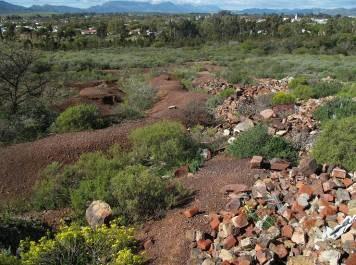
6 5 Figure 3. View of the site facing north. Robertson is in the background Figure 4. View of the site facing north. Robertson is in the background Figure 5. View of the site facing north. Robertson is in the background
7 6 4. STUDY APPROACH 4.1 Method The approach followed in the archaeological study entailed a foot survey of the proposed site. The site visit and assessment took place on the 5 th August, A desktop study was also undertaken. 4.2 Constraints and limitations The subject property is quite steep and well vegetated, resulting in poor archaeological visibility. 4.3 Identification of potential risks There are no archaeological risks associated with the project. It is unlikely (given the rocky and steep terrain of the receiving environment), but unmarked human burials may be uncovered or exposed during bulk earthworks and excavations. 4.4 Results of the desk-top study Little archaeological work has been done in the Robertson area. A few Early Stone Age tools (ESA) were located during a survey for the proposed Silverstrand development, a residential and golf course development alongside the Breede River, just outside the town (Kaplan 2003). According to Tim Hart (pers. comm.), the Archaeology Contracts Office, University of Cape Town, has not undertaken any heritage surveys in Robertson. 5. LEGISLATIVE REQUIREMENTS The following section provides a brief overview of the relevant legislation with regard to the archaeology of Erf 3 Robertson. 5.1 The National Heritage Resources Act (Act No. 25 of 1999) The National Heritage Resources Act (NHRA) requires that any development or other activity which will change the character of a site exceeding 5 000m², or the rezoning or change of land use of a site exceeding m², requires an archaeological impact assessment The relevant sections of the Act are briefly outlined below. 5.1 Structures (Section 34 (1)) Section 34 (1) of the NHRA stipulates that no person may, without a permit issued by HWC, may alter or demolish any structure or part of a structure, which is older than 60 years.

8 7 5.2 Archaeology (Section 35 (4)) Section 35 (4) of the NHRA stipulates that no person may, without a permit issued by HWC, destroy, damage, excavate, alter or remove from its original position, or collect, any archaeological material or object. 5.3 Burial grounds and graves (Section 36 (3)) Section 36 (3) of the NHRA stipulates that no person may, without a permit issued by the South African Heritage Resources Agency (SAHRA), destroy, damage, alter, exhume or remove from its original position or otherwise disturb any grave or burial ground older than 60 years, which is situated outside a formal cemetery administered by a local authority. 6. IMPACT ASSESSMENT AND DESCRIPTION One Early Stone Age quartzite flake, one possible quartzite core, and several possible quartzite chunks were located during the baseline study. The remains are very thinly and unevenly dispersed over the property. All the `tools occur on the upper slopes, in the gravel roads and on the eroded and sheet-washed slopes in the central portion of the proposed site. The archaeological heritage remains have been graded low local significance. 6.1 Other finds A historic `kruithuis (or gunpowder house) dated 1911, is situated alongside a gravel track just outside the south eastern boundary of the proposed site (refer to Figure 2 & Figure 6). GPS co-ordinates for the site are S E The structure was declared a National Monument in 1977, and is fenced off. According to Ms Becky Sachs (pers. comm.) of the Robertson Museum, the gunpowder house was built by Barry and Nephews, a large supply-order company operating in the Robertson area during the time. The monument is also indicated on the Robertson topographical map (refer to Figure 1). The National Monument plaque has unfortunately been removed from the site. Older than 60 years, the structure is protected in terms of the National Heritage Resources Act (No. 25 of 1999). The feature has been noted by the developers and planners, and will not be impacted by the proposed development. Figure 6. The historical gunpowder house, or `kruithuis
9 8 7. IMPACT STATEMENT The impact of the proposed development on pre-colonial archaeological heritage remains is likely to be low. The probability of locating significant archaeological heritage remains during implementation of the project is likely to be improbable. It is unlikely, but unmarked pre-colonial burials may also be uncovered during bulk earthworks and excavations. 8. CONCLUSION The Phase 1 Archaeological Impact Assessment of Erf 3 in Robertson has identified no significant impacts to pre-colonial archaeological material that will need to be mitigated prior to proposed development activities.
10 9 9. REFERENCES Kaplan, J Archaeological study proposed development Silverstrand Golf and Country Estate, Robertson. Report prepared for Ecosense. Agency for Cultural Resource Management.
PHASE 1 ARCHAEOLOGICAL IMPACT ASSESSMENT THE PROPOSED SWARTLAND SHOPPING MALL
 10 ( PHASE 1 ARCHAEOLOGICAL IMPACT ASSESSMENT THE PROPOSED SWARTLAND SHOPPING MALL Remainder Farm Tweefontein No. 696, Erf 2654 (Portion of Erf 327), Erf 9215 (Portion of Erf 2654) & Portion of Erf 327
PROJECT INFORMATION. The type of development
 A LETTER OF RECOMMENDATION (WITH CONDITIONS) FOR THE EXEMPTION OF A FULL PHASE 1 ARCHAEOLOGICAL HERITAGE IMPACT ASSESSMENT FOR THE PROPOSED, CONSTRUCTION OF A FILLING STATION AND ASSOCIATED INFRASTRUCTURE
ENVIRONMENTAL IMPACT ASSESSMENT
 ENVIRONMENTAL IMPACT ASSESSMENT NOTICE OF ENVIRONMENTAL IMPACT ASSESSMENT PROCESS FOR THE PROPOSED HAASENDAL DEVELOPMENT AND KUILS RIVER GOLF COURSE RE-DEVELOPMENT ON ERF 23580, ERF 23579, ERF 23582, ERF
AFRICAN HERITAGE CONSULTANTS CC 2001/077745/23
 AFRICAN HERITAGE CONSULTANTS CC 2001/077745/23 Tel/fax: (012) 567 6046 Cell: 082 498 0673 E-mail: udo@nconnect.co.za DR. UDO S KÜSEL P.O. Box 652 Magalieskruin 0150 14 June 2011 CULTURAL HERITAGE RESOURCES
N O T I F I C A T I O N O F I N T E N T T O D E V E L O P
 HWC 002/02/ED (4 Jul 14) N O T I F I C A T I O N O F I N T E N T T O D E V E L O P Completion of this form is required by Heritage Western Cape for the initiation of all impact assessment processes under
The following aspects have a direct bearing on the survey and the resulting report:
 13. ARCHAEOLOGICAL AND HERITAGE RESOURCES A Phase 1 archaeological survey of the site in accordance with the requirements of Section 38(3) of the National Heritage Resources Act (Act 25 of 1999) was conducted
MOUNTAIN VIEW HERITAGE ASSESSMENT, GAUTENG
 MOUNTAIN VIEW HERITAGE ASSESSMENT, GAUTENG A Phase I report prepared for Seaton Thompson and Associates P.O. Box 936, IRENE, 0062 Professor T.N. Huffman Archaeological Resources Management School of Geography,
BACKGROUND INFORMATION DOCUMENT (BID) AND INVITATION TO PARTICIPATE
 AND INVITATION TO PARTICIPATE") To: Interested and Affected Parties 2 October 2017 NOTIFICATION OF ENVIRONMENTAL IMPACT ASSESSMENT PROCESS FOR THE PROPOSED DEVELOPMENT OF RESIDENTIAL HOUSING ON PORTION 56 OF THE FARM CHELSEA NO. 25,
To: Interested and Affected Parties 2 October 2017 NOTIFICATION OF ENVIRONMENTAL IMPACT ASSESSMENT PROCESS FOR THE PROPOSED DEVELOPMENT OF RESIDENTIAL HOUSING ON PORTION 56 OF THE FARM CHELSEA NO. 25,
BACKGROUND INFORMATION DOCUMENT
 ENVIRONMENTAL PLANNING tel +27 21 887 4000 fax +27 21 883 2952 IMPACT ASSESSMENTS email aubrey@withersenviro.co.za web www.withersenviro.co.za MANAGEMENT SYSTEMS address P.O. Box 6118 Uniedal 7612 Our
MINIMUM STANDARDS: ARCHAEOLOGICAL AND PALAEONTOLOGICAL COMPONENTS OF IMPACT ASSESSMENT REPORTS
 111 H ARRINGTON STREET, CAPE TOWN, 8001 PO BOX 4637, CAPE TOWN, 8000 TEL: 021 462 4502 FX: 021 462 4509 TABLE OF CONTENTS MINIMUM STANDARDS: ARCHAEOLOGICAL AND PALAEONTOLOGICAL COMPONENTS OF IMPACT ASSESSMENT
BASIC ASSESSMENT PROCESS
 BASIC ASSESSMENT PROCESS NOTICE OF A BASIC ASSESSMENT PROCESS FOR THE PROPOSED MIXED USE DEVELOPMENT ON THE REMAINDER OF PORTION 2, REMAINDER OF PORTION 7, PORTION 7, REMAINDER OF PORTION 9, REMAINDER
HERITAGE WESTERN CAPE. 10 June 2015 Version 13 for Comment
 HERITAGE WESTERN CAPE 10 June 2015 Version 13 for Comment GUIDE TO GRADING IN TERMS OF THE NHRA This guide is devised to satisfy Section 7 of the National Heritage Resources Act, 1999 (Act 25 of 1999)
Chapter 8: Cultural Heritage Assessment
 Chapter 8: Cultural Heritage Assessment Cultural Heritage Assessment 8. Cultural Heritage Assessment... 2 8.1 Introduction... 2 8.2 Baseline Assessment... 2 8.3 Results / Assessment Findings... 3 8.4 Mitigation...
Figure 7.10 Feature 2 Midden 1. Feature 3
 Figure 7.10 Feature 2 Midden 1 Feature 3 This is the location where the old farm house used to be. The structure has been entirely demolished and is only marked by building rubble. The site is of no heritage
ENVIRONMENTAL IMPACT ASSESSMENT
 ENVIRONMENTAL IMPACT ASSESSMENT NOTICE OF ENVIRONMENTAL IMPACT ASSESSMENT PROCESS FOR THE SARATOGA VEGETATION CLEARING SECTION 24G ON PORTION 4 OF THE FARM KLAAS VOOGDS RIVIER NO. 40, ROBERTSON, WESTERN
HERITAGE WESTERN CAPE GUIDELINES FOR PUBLIC MONUMENTS AND MEMORIALS
 HERITAGE WESTERN CAPE GUIDELINES FOR PUBLIC MONUMENTS AND MEMORIALS Adapted from the Public Monuments and Memorials Project by SAHRA for DAC (2003) and amended following the public consultation meeting
Submitted: July 23, 2009
 Stage I and II Archaeological Assessment Jock River Estates Phase 2 PML Project No. 0801-01 Client: 773804 Ontario Inc. Lot 21, Concession 2 Geographic Township of Goulbourn City of Ottawa Submitted: July
N O T I F I C A T I O N O F I N T E N T T O D E V E L O P
 HWC 002/02/ED (4 Jul 14) N O T I F I C A T I O N O F I N T E N T T O D E V E L O P Completion of this form is required by Heritage Western Cape for the initiation of all impact assessment processes under
SITE INVESTIGATION REPORT: CONSTRUCTION OF NTUMBA VEHICULAR/PEDESTRIAN BRIDGE ACROSS A STREAM IN ROOKDALE, OKHAHLAMBA LOCAL MUNICIPALITY
 SITE INVESTIGATION REPORT: CONSTRUCTION OF NTUMBA VEHICULAR/PEDESTRIAN BRIDGE ACROSS A STREAM IN ROOKDALE, OKHAHLAMBA LOCAL MUNICIPALITY PREPARED ON BEHALF OF: ECA CONSULTING CIVIL & STRUCTURAL ENGINEERS
Heritage impact assessment for the PROPOSED BLUE HILLS EXTENSION 74 ON HOLDING 25, 32-34, BLUE HILLS AGRICULTURAL HOLDINGS, CITY OF JOHANNESBURG
 Heritage impact assessment for the PROPOSED BLUE HILLS EXTENSION 74 ON HOLDING 25, 32-34, BLUE HILLS AGRICULTURAL HOLDINGS, CITY OF JOHANNESBURG DISTRICT MUNICIPALTY, GAUTENG PROVINCE HERITAGE IMPACT ASSESSMENT
BASIC ASSESSMENT REPORT. Background Information Document
 BASIC ASSESSMENT REPORT Background Information Document BASIC ASSESSMENT FOR THE PROPOSED LUIPERDSHOEK 33 KV POWER LINE PROJECT TO BE LOCATED NORTH OF THE TOWN OF POFADDER IN THE NORTHERN CAPE (DEA Ref
Archaeological evaluation at Willowdene, Chelmsford Road, Felsted, Essex
 Archaeological evaluation at Willowdene, Chelmsford Road, Felsted, Essex August 2013 report prepared by Ben Holloway on behalf of Mr Anthony McGurren Planning reference: UTT/13/0235 CAT project ref.: 13/07g
7. The Landscape. 7.1 Introduction. Environmental Impact Statement (EIS) Scoping Report
 Scoping Report") 7. The Landscape 7.1 Introduction The purpose of this section of the EIS Scoping Report is to describe the scope of work and methods to be applied in the identification and assessment of landscape and
7. The Landscape 7.1 Introduction The purpose of this section of the EIS Scoping Report is to describe the scope of work and methods to be applied in the identification and assessment of landscape and
Chitty Farmhouse Extension, Wall Lane, Silchester, Hampshire
 Chitty Farmhouse Extension, Wall Lane, Silchester, Hampshire An Archaeological Watching Brief For In Touch by Andrew Mundin Thames Valley Archaeological Services Ltd Site Code CFS 08/52 May 2008 Summary
Foreword. Síle de Valera, TD, Minister for Arts, Heritage, Gaeltacht and the Islands
 Foreword This Code of Practice is a significant milestone in the protection of the archaeological heritage. It marks an agreement between my Department and the National Roads Authority, one of the largest
CORNUBIA RETAIL PARK- PLANNING REPORT REVERT 3
 CORNUBIA RETAIL PARK- PLANNING REPORT 19.04.2013 REVERT 3 1 FOR: BY: 28 DEVONSHIRE AVENUE GLENWOOD DURBAN 4001 P.O. BOX 17390 CONGELLA 4013 T +27 31 202 9550 F +27 31 202 9551 1st FLOOR THE MEDIA MILL
HERITAGE ASSESSMENT. Proposed 10 MW Solar Photovoltaic farm, Grootvlei Powerstation, Grootvlei, Mpumalanga Province. Version 1.1.
 HERITAGE ASSESSMENT Proposed 10 MW Solar Photovoltaic farm, Grootvlei Powerstation, Grootvlei, Mpumalanga Province Version 1.1 15 October 2012 Professional Grave Solutions (Pty) Ltd T/A PGS Heritage &
Gryme s Dyke, Stanway Green
 Gryme s Dyke, Stanway Green A short assessment of the archaeological impact of contractor s groundworks at the southern end of the Gryme s Dyke Middle earthwork February 2000 Archive report on behalf of
Cape Environmental Assessment Practitioners(Pty)
") BACKGROUND INFORMATION DOCUMENT (BID) Introduction Cape Environmental Assessment Practitioners(Pty) Ltd Reg. No. 2008/004627/07 Telephone: (044) 874 0365 First Floor, Eagles View Building Facsimile: (044)
BACKGROUND INFORMATION DOCUMENT (BID) Introduction Cape Environmental Assessment Practitioners(Pty) Ltd Reg. No. 2008/004627/07 Telephone: (044) 874 0365 First Floor, Eagles View Building Facsimile: (044)
Heritage Resources Management
 CPD Course School of Architecture, Planning and Geomatics Heritage Resources Management 6-8 August 2018 Course Objectives This three-day course is aimed at guiding professionals and lay people who need
Archaeological Monitoring of Land at 29 Royal Pier Road, Gravesend, Kent
 Archaeological Monitoring of Land at 29 Royal Pier Road, Gravesend, Kent Site Code ROY/WB/15 Report for Dr Maxted Date of report 06/10/2015 SWAT ARCHAEOLOGY Swale and Thames Archaeological Survey Company
VOLUME 2 REPORT: EIA REF NO:
 DRAFT PHASE I HERITAGE IMPACT ASSESSMENT STUDY FOR THE ESKOM TSHWANE STRENGTHENING PROJECT PHASE 1 IN PRETORIA(TSHWANE) IN THE GAUTENG PROVINCE OF SOUTH AFRICA: THE APOLLO-VERWOERDBURG SUBSTATION UPGRADE
Guidance Notes Completing an AEE
 Guidance Notes Completing an AEE The purpose of this guidance note is to assist you with completing your Assessment of Environmental Effects (AEE) for your land-use consent application. If you do not provide
Response by the Wiltshire Archaeological and Natural History Society
 Highways England Consultation A303 Stonehenge Response by the Wiltshire Archaeological and Natural History Society Background About the Society Founded in 1853 to educate the public by promoting, fostering
L 2-1 HERITAGE REPORT: REASONS FOR HERITAGE DESIGNATION. Cheyne Family Cemetery. Main Street South
 L 2-1 HERITAGE REPORT: REASONS FOR HERITAGE DESIGNATION Cheyne Family Cemetery Main Street South October 2013 L 2-2 PROFILE OF SUBJECT PROPERTY: Municipal Address Main Street South (Lot 14, Con 1, EHS)
High Speed Rail (London- West Midlands)
") High Speed Rail (London- West Midlands) Draft Environmental Minimum Requirements Annex 3: Draft Heritage Memorandum November 2013 ESA 4.4 High Speed Rail (London- West Midlands) Draft Environmental Minimum
High Speed Rail (London- West Midlands) Draft Environmental Minimum Requirements Annex 3: Draft Heritage Memorandum November 2013 ESA 4.4 High Speed Rail (London- West Midlands) Draft Environmental Minimum
Proposed Residential Development at Church Stile Farm in Cradley, Herefordshire. Hazel Dormouse Surveys
 Proposed Residential Development at Church Stile Farm in Cradley, Herefordshire A report to: Terra Strategic BSL Strategic Ltd. 2 The Courtyard 707 Warwick Road Solihull B91 3DA By: Udall-Martin Associates
Attention: Interested and Affected Party (I&AP) Commenting Period: 22 November January 2018 GNEC Code: 20327
 Commenting Period: 22 November January 2018 GNEC Code: 20327") 22 November 2017 Attention: Interested and Affected Party (I&AP) Commenting Period: 22 November 2017 15 January 2018 GNEC Code: 20327 Dear Interested and Affected Party INFORMING START OF 30 DAY PUBLIC
22 November 2017 Attention: Interested and Affected Party (I&AP) Commenting Period: 22 November 2017 15 January 2018 GNEC Code: 20327 Dear Interested and Affected Party INFORMING START OF 30 DAY PUBLIC
TAKANINI STRUCTURE PLAN AREAS 6A & 6B: ARCHAEOLOGICAL ASSESSMENT
 TAKANINI STRUCTURE PLAN AREAS 6A & 6B: ARCHAEOLOGICAL ASSESSMENT Report prepared for Hosken & Associates Ltd By Barry Baquie (MA) Rod Clough (PhD) April 2006 Clough & Associates Ltd heritage@clough.co.nz
Archaeological evaluation: land to the rear of Clare Road, Braintree, Essex
 Archaeological evaluation: land to the rear of 41-45 Clare Road, Braintree, Essex March 2014 commissioned by Mr Mark Plummer report prepared by Ben Holloway and Howard Brooks Planning reference: 13/000585/FUL,
BACKGROUND INFORMATION DOCUMENT:
 BACKGROUND INFORMATION DOCUMENT: Proposed Construction of Mpophomeni Shopping Centre, Umgungundlovu District Municipality, KZN A Project of Dymatron (Pty) Ltd 21 NOVEMBER 2014 BID DOCUMENT DESCRIPTION
Environmental Impact Assessment for Waterway Restoration Projects. Chris John, Technical Director Ecus Ltd.
 Environmental Impact Assessment for Waterway Restoration Projects Chris John, Technical Director Ecus Ltd. Environmental Impact Assessment for Waterway Restoration Projects What is Environmental Impact
Appletree, Thames Street, Sonning Berkshire
 Appletree, Thames Street, Sonning Berkshire An Archaeological Watching Brief for Mr and Mrs A Popham by Sian Anthony Thames Valley Archaeological Services Ltd Site Code ATS 02/83 October 2002 Summary Site
Perth and Kinross Council Development Management Committee 8 June Pre-Application Report by Development Quality Manager
 Perth and Kinross Council Development Management Committee 8 June 2016 5(3)(i) 16/259 Pre-Application Report by Development Quality Manager Residential development at St Martins Road, Land 120 metres West
PROPOSED NGWADINI WEIR AND ABSTRACTION WORKS, PIPELINE AND ACCESS ROAD, LOWER UMKHOMAZI BULK WATER SUPPLY SCHEME, KWAZULU-NATAL
 PROPOSED NGWADINI WEIR AND ABSTRACTION WORKS, PIPELINE AND ACCESS ROAD, LOWER UMKHOMAZI BULK WATER SUPPLY SCHEME, KWAZULU-NATAL Phase 1 Heritage Impact Assessment October 2017 Client: Nemai Consulting
Ivol Buildings, Woodcote Road, South Stoke, Oxfordshire
 Ivol Buildings, Woodcote Road, South Stoke, Oxfordshire An Archaeological Watching Brief For Christ Church, Oxford by Pamela Jenkins Thames Valley Archaeological Services Ltd Site Code IBSS 04/03 March
Ref: A073350/SM/sm Date: 13 September 2013
 Ref: A073350/SM/sm Date: 13 September 2013 Ian Parkinson Development Control Team Leader Planning Portsmouth City Council Civic Offices Guildhall Square Portsmouth PO1 2AY Dear Ian LIGHT & GLEAVE VILLA
9 Archaeology & Cultural Heritage
 High Clachaig Wind Farm Scoping Report Page 56 9 Archaeology & Cultural Heritage 9.1 Introduction Cultural heritage in this context means the above- and below-ground archaeological resources, built heritage,
Settlement Boundaries Methodology North Northumberland Coast Neighbourhood Plan (August 2016)
") Introduction This background paper sets out a methodology for the definition of settlement boundaries in the North Northumberland Coast Neighbourhood Plan. The neighbourhood plan is planning positively
Introduction This background paper sets out a methodology for the definition of settlement boundaries in the North Northumberland Coast Neighbourhood Plan. The neighbourhood plan is planning positively
Centre for Archaeological Fieldwork, School of Archaeology and Palaeoecology, Queen s University Belfast.
 Centre for Archaeological Fieldwork, School of Archaeology and Palaeoecology, Queen s University Belfast. Monitoring Report No. 04 Duneight Motte and Bailey, May 2004. On behalf of Monitoring Report: Duneight
BACKGROUND INFORMATION DOCUMENT
 BACKGROUND INFORMATION DOCUMENT PROPOSED UPGRADING OF THE N2 NATIONAL ROAD FROM KRAAIBOSCH TO DIE VLEIE BASIC ENVIRONMENTAL IMPACT ASSESSMENT The South African National Roads Agency Society Limited (SANRAL)
WELCOME. Welcome and thank you for visiting today.
 WELCOME Welcome and thank you for visiting today. Bellway Homes Ltd (Yorkshire) are preparing a reserved matters planning application for a residential development of 293 homes at land North of Yew Tree
Cultural Heritage Resources
 Cultural Heritage Resources An Information Bulletin for Projects Subject to Ontario Regulation 359/09 - Renewable Energy Approvals Ministry of Tourism, Culture and Sport 2011 (updated August 2013) Disclaimer:
APPENDIX A 6 CONCEPTUAL PRELIMINARY PLAN GUIDE AND CHECKLIST FOR MAJOR SUBDIVISIONS CARRBORO DEVELOPMENT GUIDE APPENDIX A
 6 CONCEPTUAL PRELIMINARY PLAN GUIDE AND CHECKLIST FOR MAJOR SUBDIVISIONS Conceptual Preliminary Guide/Checklist for Major Subdivisions Page 1 FORM: REVIEW DATE: CONCEPTUAL PLAN REVIEW 2000 REVIEWED BY:
Town of Cobourg Heritage Master Plan. Statutory Public Meeting
 Town of Cobourg Heritage Master Plan Statutory Public Meeting April 25 th 2016 Presentation Overview 1. Introduction 2. Project background and schedule overview 3. Review of strategic direction content
Examination of South Cambridgeshire Local Plan
 Matter SC6A - Policy SS/5 Waterbeach New Town Historic England( formerly English Heritage) 874 Rep Nos 59748, 60250, 60253 Examination of South Cambridgeshire Local Plan Historic England, Hearing Statement
9 CITY OF VAUGHAN OFFICIAL PLAN AMENDMENT NO BOCA EAST INVESTMENTS LIMITED
 9 CITY OF VAUGHAN OFFICIAL PLAN AMENDMENT NO. 631 - BOCA EAST INVESTMENTS LIMITED The Planning and Economic Development Committee recommends the adoption of the recommendations contained in the following
Sewanee Village + Request for Builder/Developer Proposals
 Sewanee Village + Request for Builder/Developer Proposals Contact: Frank X. Gladu Special Assistant to the Vice Chancellor University of the South 735 University Ave Version 3 Sewanee TN 37383 Released:
APPENDIX 9: Archaeological Assessment by Ken Phillips
 APPENDIX 9: Archaeological Assessment by Ken Phillips ARCHAEOLOGICAL ASSESSMENT PROPOSED SERVICE STATION DEVELOPMENT BRUCE ROAD, PAPAMOA TAURANGA Prepared by KEN PHILLIPS (MA HONS) MARCH 2016 ARCHAEOLOGY
Report on a soil survey and agricultural suitability investigation of the property known as Erf 660, De Doorns.
 De Doorns erf 660 Soil Report 1 Report on a soil survey and agricultural suitability investigation of the property known as Erf 660, De Doorns. by F. Ellis September 2006 CONTENTS 1 INTRODUCTION AND TERMS
PURPOSE OF MEETING MEETING GUIDELINES PROJECT BACKGROUND ESKOM CLOCOLAN-FICKSBURG 88 KV POWERLINE, FREE STATE
 ESKOM CLOCOLAN-FICKSBURG 88 KV POWERLINE, FREE STATE DRAFT BASIC ASSESSMENT REPORT PUBLIC REVIEW LANDOWNERS MEETING FICKSBURG 23 JULY 2013 T his project is being conducted on behalf of Eskom PRESENTATION
APPENDIX 1: SCOPED ENVIRONMENTAL IMPACT STATEMENT (EIS) FORM
 FORM") APPENDIX 1: SCOPED ENVIRONMENTAL IMPACT STATEMENT (EIS) FORM This form is intended for use by applicants (primarily private landowners) who need to conduct a Scoped EIS in support of minor development
APPENDIX 1: SCOPED ENVIRONMENTAL IMPACT STATEMENT (EIS) FORM This form is intended for use by applicants (primarily private landowners) who need to conduct a Scoped EIS in support of minor development
Dorenell Wind Farm 132 kv Grid Connection
 Who We Are Scottish and Southern Energy Power Distribution is part of the SSE plc group of companies. We own, maintain and invest in the electricity networks in the north of Scotland the electricity transmission
Neighbourhood Plan Representation
 Date: 10 th November 2017 Neighbourhood Plan Representation Land to the east of Callow Hill Road, Alvechurch Introduction This representation has been prepared by RPS Planning and Development on behalf
Newcombe House & Kensington Church Street
 Newcombe House & Kensington Church Street Archaeological Evaluation September 2017 Summary Site name: Newcombe House, Kensington Church Street, Notting Hill, London Grid reference: TQ 25318 80372 Site
3.1 This evidence is based on the landscape and visual impact assessment included in Chapter 10 and Appendix I of the EIS.
 LANDSCAPE & VISUAL 1 QUALIFICATIONS AND EXPERIENCE 1.1 My name is Raymond Holbeach and I am a Regional Director for RPS Planning & Environment with full responsibility for management of the RPS Belfast
CPA , Bristoe Station and Kettle Run Preservation Study Comprehensive Plan Amendment
 Bristoe Station and Kettle Run Battlefields Special Study Area Introduction and Background The Bristoe Station Battlefield consists of approximately 9,410 acres. This battle on October 14, 1863, was the
Draft Western District Plan
 Powered by TCPDF (www.tcpdf.org) Draft Western District Plan Submission_id: 31440 Date of Lodgment: 15 Dec 2017 Origin of Submission: Online Organisation name: Goodman Property Services Australia Pty Ltd
Cultural Heritage Resources
 Cultural Heritage Resources An Information Bulletin for Projects Subject to Ontario Regulation 359/09 - Renewable Energy Approvals DRAFT Ministry of Tourism, Culture and Sport 2011 (updated September 2012)
Prepared for: Ontario Limited
 Application for Zoning By-law Amendment and Plan of Subdivision 1353 Scharfgate Drive Planning Rationale Report Prepared for: 1384341 Ontario Limited November 28, 2014 Revised August 18, 2015 Planning
Digital Terrestrial Television Infrastructure Rollout. Environmental Impact Assessment - Corridor -
 Digital Terrestrial Television Infrastructure Rollout Environmental Impact Assessment - Corridor - 1 1 ENVIRONMENTAL IMPACT ASSESSMENT (EIA): CORRIDOR 1.1 INTRODUCTION Corridor is a small farming community
24. ARCHAEOLOGY & BUILT HERITAGE
 24. ARCHAEOLOGY & BUILT HERITAGE Overview There are no known archaeological or built heritage sites within or adjacent to the Project designation boundaries. There is a history of both Māori and European
GUIDELINES FOR CULTURAL HERITAGE IMPACT ASSESSMENTS
 GUIDELINES FOR CULTURAL HERITAGE IMPACT ASSESSMENTS Purpose A Cultural Heritage Impact Assessment (CHIA) is a study to identify and evaluate built heritage resources and cultural landscapes in a given
MANAGING CHANGE IN THE HISTORIC ENVIRONMENT. Historic Battlefields August 2016
 MANAGING CHANGE IN THE HISTORIC ENVIRONMENT Historic Battlefields August 2016 Above: Most of Culloden battlefield lay under forestry until clearance by the National Trust for Scotland in the 1980s. While
Kier Infrastructure and Overseas Limited Greenburn Surface Mine, Dalgig Farm Site
 Kier Infrastructure and Overseas Limited Greenburn Surface Mine, Dalgig Farm Site Planning application pursuant to s.42 Town and Country Planning (Scotland) Act 1997 to amend the restoration scheme Volume
Land Use Amendment in Southwood (Ward 11) at and Elbow Drive SW, LOC
 at and Elbow Drive SW, LOC") 2018 November 15 Page 1 of 10 EXECUTIVE SUMMARY This land use amendment application was submitted by Rick Balbi Architect on 2017 August 31 on behalf of Sable Developments Ltd, and with authorization from
2018 November 15 Page 1 of 10 EXECUTIVE SUMMARY This land use amendment application was submitted by Rick Balbi Architect on 2017 August 31 on behalf of Sable Developments Ltd, and with authorization from
Municipal Class EA Study Public Information Centre No. 1 December 13, :00 pm 7:00 pm. Please sign in so we can keep you updated on this study
 Reconstruction of Regional Road 45 (Creek Road) Between Regional Road 27 (River Road) and Regional Road 63 (Canborough Road) in the Township of Wainfleet Municipal Class EA Study Public Information Centre
HISTORIC TEXAS CEMETERY REQUEST FOR DESIGNATION
 HISTORIC TEXAS CEMETERY REQUEST FOR DESIGNATION List additional descriptions or information on separate pages, if necessary. IDENTIFYING INFORMATION Primary name: Also known as: County: Type: Single grave
Goal 1 To establish and follow land use patterns for the long-range development of the campus.
 ELEMENT 4 FUTURE LAND USE Goal 1 To establish and follow land use patterns for the long-range development of the campus. Objective 1A Correct existing incompatible campus land uses. Policy 1A-1 Reduce
ENVIRONMENTAL IMPACT ASSESSMENT
 ENVIRONMENTAL IMPACT ASSESSMENT NOTICE OF APPLICATION FOR AMENDMENT OF AN ENVIRONMENTAL AUTHORISATION FOR THE HAASENDAL DEVELOPMENT ON PORTIONS 1, 11, 26, 30, 34, 58, AND 87 OF FARM HAASENDAL NO. 222,
Chapter 10 IMPLEMENTATION RECOMMENDATIONS
 Chapter 10 IMPLEMENTATION RECOMMENDATIONS The recommended land use plan presented in the previous chapter provides a design for the attainment of the urban and rural development and open space preservation
VILLAGE OF BOLTON HERITAGE CONSERVATION DISTRICT PLAN
 Page 1 1. INTRODUCTION AND BACKGROUND 1.1 THE PROJECT VILLAGE OF BOLTON HERITAGE CONSERVATION DISTRICT PLAN TERMS OF REFERENCE The Town of Caledon (Town) is a large, predominantly rural municipality with
XSW11, Plumstead Portal worksites, Interim Statement for NLBH. 1 Introduction Site Methodology and fieldwork objectives...4
 Contents 1 Introduction...4 2 Site Methodology and fieldwork objectives...4 2.1 NLBH Methodology... 4 2.2 NLBH Fieldwork Objectives... 5 3 Provisional Results...6 3.1 NLBH various features... 6 3.2 Shelter
City of Waco Stormwater Management Regulations
 1.0 Applicability: City of Waco Stormwater Management Regulations These regulations apply to all development within the limits of the City of Waco as well as to any subdivisions within the extra territorial
BUSHFIRE CONSTRAINTS ASSESSMENT FOR THE SHONE AVENUE WEST DAPTO ROAD NEIGHBOURHOOD PLAN HORSLEY
 BUSHFIRE CONSTRAINTS ASSESSMENT FOR THE SHONE AVENUE WEST DAPTO ROAD NEIGHBOURHOOD PLAN HORSLEY Australian Bushfire Protection Planners Pty Limited ACN 083 085 474 32 Old Dog Trap Road, SOMERSBY 2250 NSW.
Archaeological Evaluation and Assessment of Land at Kent Cottage, 19 Chapel Street, Hythe, Kent
 Archaeological Evaluation and Assessment of Land at Kent Cottage, 19 Chapel Street, Hythe, Kent Planning Application Y13/0463/SH Date of Report: 29/04/2015 Report for Marc Carney SWAT. ARCHAEOLOGY Swale
For: Terratest (Pty) Ltd. Frans Prins Cell: Fax:
 Ltd. Frans Prins Cell: Fax:") CULTURAL HERITAGE IMPACT ASSESSMENT OF THE PROPOSED ESTABLISHMENT OF A RESIDENTIAL DEVELOPMENT AT THE OLD DAIRY SITE, HILTON COLLEGE, UMNGENI LOCAL MUNICIPALITY, KWAZULU-NATAL. For: Terratest (Pty) Ltd
CULTURAL HERITAGE IMPACT ASSESSMENT OF THE PROPOSED ESTABLISHMENT OF A RESIDENTIAL DEVELOPMENT AT THE OLD DAIRY SITE, HILTON COLLEGE, UMNGENI LOCAL MUNICIPALITY, KWAZULU-NATAL. For: Terratest (Pty) Ltd
Barvills Solar Farm Environmental Statement Non-Technical Summary
 Barvills Solar Farm Environmental Statement Non-Technical Summary 13 March 2015 Produced for Prepared by St John s House Queen Street, Manchester M2 5JB Contents Contents... 2 1 Introduction... 3 1.1 Development
Land adjacent to Dingle Dock, Front Street, East Garston
 Land adjacent to Dingle Dock, Front Street, East Garston An Archaeological Watching Brief for Dr J Davies by Jo Pine Thames Valley Archaeological Services Site Code DEG99/82 January 2000 Summary Site name:
MINISTRY OF TRANSPORTATION. Environmental Guide for Built Heritage and Cultural Heritage Landscapes
 MINISTRY OF TRANSPORTATION Environmental Guide for Built Heritage and Cultural Heritage Landscapes Version: February 2007 MINISTRY OF TRANSPORTATION Environmental Guide for Built Heritage and Cultural
H e r i t a g e I n v e s t i g a t i o n. C l i f t o n P r e c i n c t D e v e l o p m e n t A r e a C L I F T O N, C A P E T O W N.
 H e r i t a g e I n v e s t i g a t i o n C l i f t o n P r e c i n c t D e v e l o p m e n t A r e a C L I F T O N, C A P E T O W N prepared for C I T Y O F C A P E T O W N Property Management Department,
REPORT AND SPECIFICATION FOR RESTORATION WORKS ON NELLIES GLEN ROAD and THE 6 - FOOT TRACK NELLIES GLEN
 REPORT AND SPECIFICATION FOR RESTORATION WORKS ON NELLIES GLEN ROAD and THE 6 - FOOT TRACK NELLIES GLEN Prepared for Crown Lands, Parramatta DEPARTMENT OF LANDS SOIL CONSERVATION SERVICE Greater Metropolitan
R101 TO MORETELE LOCAL MUNICIPALITY SOUTH BULK WATER SUPPLY SYSTEM
 R101 TO MORETELE LOCAL MUNICIPALITY SOUTH BULK WATER SUPPLY SYSTEM Heritage Impact Assessment February 2015 Updated January 2017 ENVIRONMENTAL AND SOCIAL CONSULTANTS P.O. BOX 1673 SUNNINGHILL 2157 147
14.5 HOPEFIELD: (REFER PLAN 39 AND PLAN 40)
") URBAN DYNAMICS WESTERN CAPE INC. 248 14.5 HOPEFIELD: (REFER PLAN 39 AND PLAN 40) FIGURE 83: LOCALITY - HOPEFIELD Within the context of the Saldanha Bay Municipal area, Hopefield, an historical agricultural
URBAN DYNAMICS WESTERN CAPE INC. 248 14.5 HOPEFIELD: (REFER PLAN 39 AND PLAN 40) FIGURE 83: LOCALITY - HOPEFIELD Within the context of the Saldanha Bay Municipal area, Hopefield, an historical agricultural
South of Hillside Road West, Rothbury. Design and Access Statement with Design Code. Outline Planning Application May 2016
 Outline Planning Application May 2016 Design and Access Statement with Design Code Jane Darbyshire and David Kendall Ltd This Design and Access Statement has been produced by Jane Darbyshire and David
Comprehensive and Professional Solutions for all Heritage Related Matters CK 2006/014630/23 VAT NO.:
 Comprehensive and Professional Solutions for all Heritage Related Matters CK 2006/014630/23 VAT NO.: 4360226270 REPORT ON A PHASE 1 HERITAGE ASSESSMENT FOR THE PROPOSED BLOEHOF EXTENSIONS 11, 12 & 13 TOWNSHIP
(Assessment conducted under Section 38 of the National Heritage Resources Act No 25 of 1999)
") HERITAGE IMPACT ASSESSMENT FOR THE FARM 294 AMANZI ESTATE, PORTION 4 OF THE FARM 296 AMANZI MOOI WATER, ERF 296 PORTION 3 OF RIETHEUVEL AND ERF 296 RIETHEUVEL, IN THE NELSON MANDELA BAY MUNICIPALITY, EASTERN
HERITAGE IMPACT ASSESSMENT FOR THE FARM 294 AMANZI ESTATE, PORTION 4 OF THE FARM 296 AMANZI MOOI WATER, ERF 296 PORTION 3 OF RIETHEUVEL AND ERF 296 RIETHEUVEL, IN THE NELSON MANDELA BAY MUNICIPALITY, EASTERN
LIDBURY, SUMMERS & WHITEMAN
 LIDBURY, SUMMERS & WHITEMAN Consulting Surveyors, Planners & Engineers Incorporating Degotardi, Smith & Partners (Forster) The Institution of Surveyors NSW The Institution of A.B.N. 48 470 231 954 P.O.
Bushfire Management Plan
 Bushfire Management Plan Wentworth West Estate Bartram Road, Success LUSH FIRE & PLANNING PO Box 114 Woodanilling WA 6316 0418 954 873 ABN 74 232 678 543 Ref 18-004 Ver D May 2018 Site Address / Plan Reference:
Rannoch 132 / 33 kv Substation Extension
 Who we are Scottish and Southern Energy Power Distribution is part of the SSE plc group of companies. We own, maintain and invest in the networks in the north of Scotland the electricity transmission network