METROPOLITAN COUNCIL 390 North Robert Street, St. Paul, MN Phone (651) ; TDD (651)
|
|
|
- Susan Franklin
- 5 years ago
- Views:
Transcription
1 DATE: December 20, 2011 METROPOLITAN COUNCIL 390 North Robert Street, St. Paul, MN Phone (651) ; TDD (651) TO: Metropolitan Parks and Open Space Commission FROM: Tori Dupre, Senior Planner-Parks ( ) SUBJECT: (2011-XXX) Minnesota River Greenway Regional Trail Master Plan, Dakota County, Review File No Metropolitan Parks and Open Space Commission Districts G (Carrie Wasley) and H (Barbara Schmidt) Metropolitan Council Districts 13 (Richard Kramer) and 15 (Steven T. Chávez) INTRODUCTION Dakota County, the regional park implementing agency, submitted the Minnesota River Greenway regional trail master plan to the Metropolitan Council for review on November 2, The Council reviews park and trail master plans to evaluate their consistency with the 2030 Regional Parks Policy Plan and its content criteria for regional trail master plans. The 2030 Regional Parks Policy Plan Planning Strategy 1 (page 2-28) describes the role of the master plan in the regional park system. The policy requires that any project proposed for funding in the Metropolitan Regional Parks Capital Improvement Plan (CIP) be consistent with a Metropolitan Council-approved regional park master plan. The Policy Plan Siting and Acquisition Strategy 3 (page 2-15) addresses locating and acquiring new regional trails and specifies that new regional trails serve a regional audience based on visitor origin surveys, follow natural or linear features in areas of scenic appeal, and provide connections between the regional park system s features and facilities. This report reviews the proposed Minnesota River Greenway Regional Trail master plan based on its consistency with the 2030 Regional Parks Policy Plan and recommends approval of the master plan. AUTHORITY TO REVIEW Minnesota Stat Subd. 1 requires Regional Park Implementing Agencies to prepare, after consultation with all affected municipalities, and submit to the Metropolitan Council, and from time to time revise and resubmit to the council, a master plan and annual budget for the acquisition and development of regional recreation open space located within the district or county, consistent with the Council s policy plan. Minnesota Stat Subd. 2, authorizes the Metropolitan Council to review, with the advice of the Metropolitan Parks and Open Space Commission, master plans for the regional park system facilities. The Council reviews plans for their consistency with the 2030 Regional Parks Policy Plan, and those plans found inconsistent with Council policy


2 are returned to the implementing agency, along with the Council s review comments, for revision and resubmission. BACKGROUND

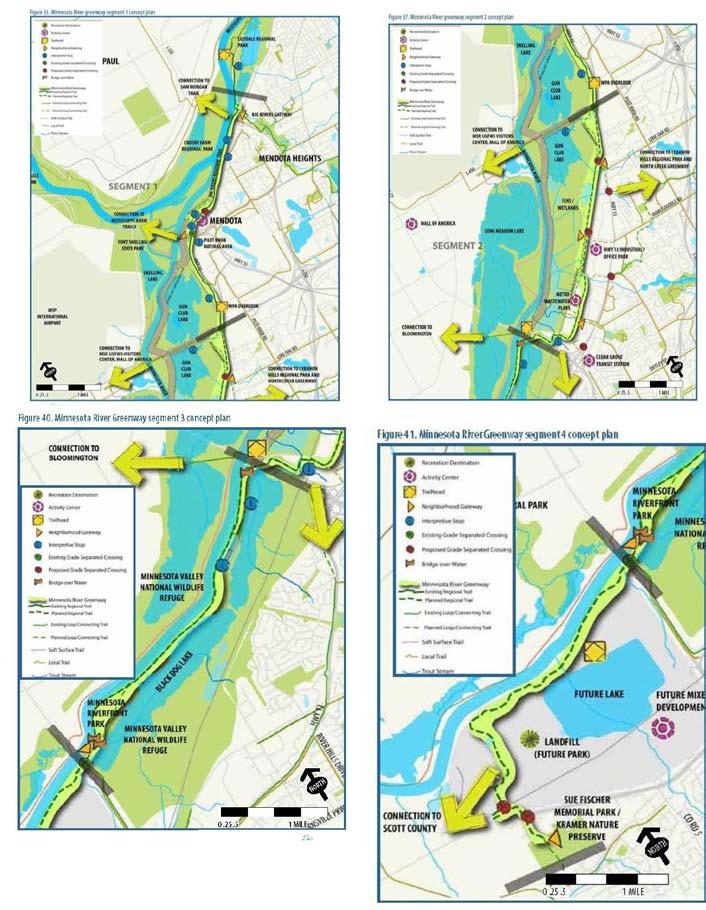
3 The Policy Plan acknowledges the proposed regional trail in Dakota County as an extension of an existing regional trail (Big Rivers Regional Trail) southward to the Scott County border. The Policy Plan explains that greenways are similar to regional destination trails, and states that greenways, like destination trails, should maximize the amount of high-quality natural resources within the trail corridor boundaries. The Dakota County 2030 comprehensive plan supports the greenway and regional trail through the Countywide Greenways Vision, connecting land resources, water resources and natural resources in a recreational setting. The County adopted a Greenway Guidebook that establishes a collaborative approach to greenway governance, stewardship, design and operation. The proposed 17-mile regional trail extends from Dakota County s border with Scott County to the City of St. Paul, following the Minnesota River. It will access unique cultural and natural resources within the Cities of Burnsville, Eagan, Mendota Heights, Mendota and Lilydale. Also, it will connect to St. Paul s Lilydale Regional Park and to Harriet Island. This regional trail corridor is a part of the Minnesota Department of Natural Resources (DNR) planning for the Minnesota Valley State Trail, extending from St. Paul to LeSueur MN. The master plan describes the regional trail in the following four segments: Segment 1 from Lilydale Regional Park, south to I-494 (5 miles); Segment 2 from I-494 to Cedar Avenue (4 miles); Segment 3 from Cedar Avenue to I- 35W (3.5 miles) and Segment 4 from I-35W to Scott County (4 miles).
4
5 Much of the proposed regional trail lies within the Minnesota Valley National Wildlife Refuge, Fort Snelling State Park, in St. Paul s regional parks, or in Burnsville s local parks. The broader greenway corridor contains 26 known archaeological sites and 11 historical properties that are listed in the National Register of Historic Places. MASTER PLAN ANALYSIS The 2030 Regional Parks Policy Plan requires that master plans for regional destination trails address the following twelve items. 1. Boundaries and Acquisition Costs The master plan addresses the parcels to be acquired, the estimated acquisition costs and schedule for the proposed regional trail. It also describes the trail corridor s natural resources, suitability, special assessments and other acquisition considerations. This review evaluates the proposed regional trail portion of the broader greenway. While the County will be responsible for the 30-foot trail, the broader greenway corridor will be governed by other partner agencies such as the Minnesota DNR. The proposed trail will include a 30-foot paved trail within a 100 to 300-foot greenway corridor, depending upon the location, and will connect or follow natural resource areas where possible. The corridor s acquisition will occur in phases, and the anticipated schedule depends upon funding and the County s acquisition priorities identified in the plan. The master plan states that it is essential that Dakota County secure land for the 30-foot trail alignment and the trailheads. The master plan identifies the corridor parcels that need to be protected by ownership type, from public to private. The proposed trail corridor includes approximately 14.2 acres of private land. The County will work with the private landowners to protect the trail corridor through ongoing negotiations regarding trail easements, and land acquisition through bargain sales or donations. The master plan estimates the private land acquisition costs to be approximately $90.00 per linear foot, or approximately $1,845,000. Actual acquisition costs will vary based on strategy, ranging from direct purchase, easement purchase, land donation, or bargain sale. The acquisition schedule will correspond to the project phases and available funding. 2. Demand Forecast The master plan addresses how the trail will meet the recreational demand as identified by Council and Dakota County. The master plan indicates that the 13 communities in the trail corridor are some of the most densely populated in the metropolitan area, having a 2009 total population of over one million. The proposed trail will fulfill recreation needs in this part of the County. Dakota County s past resident surveys have clearly shown that trails are the number one desired recreation facility. The Metropolitan Council s 2009 visit estimate for the existing portion of the regional trail, the 4.5-mile Big Rivers Regional Trail, was 142,000 visits. Based on the current use patterns, the trail would have 539,000 annual visits, if the entire regional trail was

6 open today. With the projected 2030 population of 1,191,200, a 16 percent increase, the annual visits can be expected to surpass 625, Development Concept The master plan addresses the trail development schedule and cost estimates. Dakota County will implement the trail development in phases with first and second priorities identified, and long-term trail improvements and enhancements. The top priority projects are those that form the basic, continuous trail. Secondary priorities add trail enhancements such as grade-separated trail crossings at roadways. Long-term priorities add an underpass, landscaping and resource restoration, trailhead and gateway, or trail entrance with restroom, wayfinding, water, benches and parking. The County will implement the project segments, beginning with the top priorities, as funding opportunities become available. The County intends to fund the trail development in coordination with the cities, the federal government and the state of Minnesota. Dakota County will design the proposed trail to function as a regional destination trail for nature-oriented recreation and non-motorized transportation. The greenway width will range from 100 feet to more than 1.5 mile throughout the corridor. The minimum trail width will be 30-feet to meet safety and access guidelines and provide year-round trail use. This graphic represents a typical section of proposed regional trail and the broader greenway. The master plan provides estimated development costs by trail segment and priority ranking. Therefore, the total development costs for the first priority segments are an estimated $5,786,368. The total development costs for the entire trail are an estimated $12 million dollars. This total cost includes first and second priority segments, and long-term trail enhancements in today s dollars.
7 4. Conflicts The master plan addresses the potential conflicts with existing land uses or proposed projects affecting the trail, including the steps necessary for resolution. The master plan indicates that the surrounding land uses are generally compatible with the proposed trail. Dakota County will work with individual landowners to resolve issues and concerns with the trail construction, maintenance and safety on a case by case basis. The master plan identifies where the trail will cross roads and railroads, and the need for grade-separated crossings to reduce conflicts between trail users and motorized traffic. The Metropolitan Council Environmental Services (MCES) identified a potential conflict at the Seneca wastewater treatment facility in Eagan, where the proposed trail crossed Comanche Road, the treatment plant facility s only access to and from the regional facility. The County acknowledged the concern and identified a grade-separated crossing at this location in the master plan text, development costs and graphics. The County is committed to working with MCES as the trail is built near the treatment plant and interceptor facilities. 5. Public Services The master plan indicates that no new public services (non-recreation services and facilities) will be needed to accommodate the trail. Proposed trailheads and neighborhood gateways are currently served by the existing road network. Dakota County will consider options such as solar lighting if municipal utilities are not accessible at these trailhead and gateway locations. As the County continues to build the trail system, it will consider options for future trail illumination, an essential component for trail safety and navigation. 6. Operations The master plan addresses the rules, regulations or ordinances affecting the trail, including estimated operations and maintenance costs, and sources of revenue to operate and maintain the trail. Dakota County enforces its park ordinance that defines and regulates park and trail rules and use. It identifies facility operation and hours, permitted recreation activities, vehicle traffic and parking, park and trail rules, regulation and enforcement. The County will communicate these rules on kiosks and signs to provide information on hours, trails, permitted activities and fees. The County officers patrol the park and trail facilities, educate visitors, enforce ordinances and respond to emergencies. The Dakota County Parks and Open Space Department will be the lead agency for coordinating the regional trail and management operations, and the County and will fund the park and trail operations through the annual budget. Dakota County will develop a joint powers agreement with the partner agencies for future facility maintenance. The master plan identifies the annual maintenance and operations costs for the 30-foot trail corridor including gateways, trailheads and grade separated crossings for each trail segment. The annual trail maintenance cost is an estimated 255,000.
8 7. Citizen Participation The master plan addresses the citizen participation process that the County incorporated in planning the regional trail. The County led a 12-month master planning process that included 14 members from a technical advisory group including the following communities and agencies. The County established a project website that provided an interactive map and a virtual open house to collect feedback and comments from the public on the proposed trail and greenway. The County notified over 2,000 residents within a quarter-mile of the greenway, inviting them to two public open houses and held a workshop to present interpretive themes. The County met with stakeholders including the technical advisory group communities, the MCES staff, the DNR staff and Xcel Energy. Technical Advisory Group Members Cities Govt. Dakota County Lilydale U.S. Fish and Wildlife Service Dakota Co Historical Society Mendota MN Dept of Natural Resources Dakota Co Dept of Public Mendota Heights Eagan Burnsville Lower MN River Watershed District Fort Snelling State Park Minnesota Historical Society Health Dakota Co Parks & Open Space Dept Dakota Co Office of Planning and Analysis 8. Public Awareness The master plan addresses the County s approach to make the public aware of the services available when the trail is open. Dakota County uses many communication tools to promote the parks and trails including websites, mailings, press releases, brochures and wayfinding systems. The master plan discusses options for a wayfinding and interpretive sign system for the entire trail, and highlights the National Park Service system of interpretive signs. The master plan includes recommendations for a system-wide regional trail interpretive plan that incorporates stakeholder input, interpretive themes and consistent design standards. 9. Accessibility The master plan addresses Dakota County s commitment to provide activities, access and resources to all trail visitors. The regional trail will be a continuous multipurpose, bituminous trail designed to meet federal, state and county trail standards. The trail will be constructed to specifications of 10 to 12 feet wide, with a three-foot clear zone on both sides, and will accommodate walking, jogging, inline skating and bicycling. The trail will be maintained for winter use and illuminated where possible. Frequent access is a priority for the Minnesota River regional trail and the County will provide two types of access. Trailheads are intended for regional and local access, while gateways are intended for local access. Access points will be at recreation

9 destinations, activity centers and trail intersections where support facilities will provide water, restrooms and trail information. 10. Stewardship Plan The master plan addresses the County s program to manage the corridor s natural resources. Given the trail corridor length, the County will work with partner agencies to implement a resource stewardship plan. The master plan identifies five key habitat investment areas as priorities for restoration (figure 48) where the County will focus restoration and protection efforts near trailheads to provide opportunities for trail users to observe the projects. These projects will include stream restoration, wetland restoration, invasive plant removal, and native plant restoration. The estimated total
10 cost of these resource restoration projects is $450, Natural Resources The master plan includes a natural resource inventory (NRI) that is consistent with the DNR s Minnesota Land Cover Classification System (MLCCS). The master plan indicates that the Minnesota River corridor is rich in cultural and natural resources. The vegetation along the trail is primarily wetland that including calcareous fens, with some prairie, woods and remnant floodplain forests. The DNR s County Biological Survey identified many areas within the river valley as some of the highest quality habitat in the country. The river valley has numerous state and federal endangered plant species, and four trout streams. The County used the MLCCS information during the trail master planning process and conducted resource field verification. REVIEW BY OTHER COUNCIL DIVISIONS The Metropolitan Council staff reviewed the master plan for potential issues with the other regional systems plans for water resources management, wastewater and transportation (including aviation). The Council staff found that the proposed trail is compatible with the regional systems plans. However, the Metropolitan Council Environmental Services (MCES) staff had concerns with the trail s proximity near two essential regional facilities, the Seneca wastewater treatment plant (WWTP) and the adjacent regional maintenance facility (RMF) in the City of Eagan. Environmental Services (Bryce Pickart, ) The MCES staff found that the master plan, showing a grade-separated road crossing at Comanche Road in the text, graphics and cost estimates, is acceptable and satisfies the Council s safety concerns. Comanche Road provides access to and from the Seneca WWTP and the adjacent RMF, two essential regional facilities that serve the County and the greater metro area. The proposed trail alignment crosses MCES property north of RMF and south of the Seneca WWTP. The Council s safety concerns include frequent truck traffic (deliveries) to and from the Seneca WWTP, as well as periodic heavy truck and equipment traffic during construction projects. The master plan indicates that the County will work with MCES to discuss the trail alignment, alternatives and final designs to protect access to the wastewater treatment plant facility, and to acknowledge any necessary WWTP expansions. Environmental Services, Sewers (Roger Janzig, ) The proposed trail alignment crosses the following six Metropolitan Council-owned gravity interceptors. 1. (8360) in Mendota; interceptor built in 1985; 6 inch DIP 2. (3-ET-37) in Eagan; interceptor built in 1965; 36 inch RCP 3. (7032) in Eagan; interceptor built in 1970: 54 inch RCP/CIPP 4. (7031) in Eagan; interceptor built in 1971; 42 inch Steel Pipe 5. (9003) in Eagan; interceptor built in 1996: 32 inch HDPE
11 6. (8560) in Burnsville; interceptor built in 1987; 14 inch PVC The Council recommends that Dakota County contact Scott Dentz (MCES interceptor engineering manager, , to review preliminary project plans and assess any potential impacts to our interceptor system prior to project initiation. The County may mail engineering drawings and detail to Scott at 3565 Kennebec Drive, Eagan MN CONCLUSIONS 1. The Minnesota River Greenway regional trail master plan from Dakota County is consistent with the 2030 Regional Parks Policy Plan. 2. The estimated costs to implement the regional trail master plan total $14,295,300 which includes cost estimates for acquisition, $1,845,000, construction, $12,000,000, and stewardship (resource restoration), $450, The proposed trail alignment crosses Comanche Road, the access to the Seneca WWTP the adjacent RMF, where a grade-separated road crossing addresses the MCES safety concerns. Dakota County will work with MCES on the proposed trail alignment, alternatives and final designs to protect the access to the Seneca WWTP and the RMF. 4. The proposed trail alignment affects six regional interceptors and related easements. Dakota County will work with MCES as trail engineering and detail are prepared and will provide the information to MCES staff for review, to maintain the integrity of these regional wastewater interceptor facilities. 5. The Council s action of the master plan allows Dakota County to be eligible to request regional funding for the trail s acquisition, development, operations, maintenance. RECOMMENDATIONS: That the Metropolitan Council: 1. Approve the Minnesota River Greenway Regional Trail Master Plan. 2. Require Dakota County to provide trail alignment plans to MCES for review to protect the access to the Seneca WWTP and adjacent RMF. 3. Require Dakota County to provide trail development plans to MCES for review and comment to ensure the integrity of the wastewater treatment interceptor system.
METROPOLITAN COUNCIL 390 North Robert Street, St. Paul, MN Phone (651) ; TDD (651)
 ; TDD (651)") DATE: October 24, 2012 METROPOLITAN COUNCIL 390 North Robert Street, St. Paul, MN 55101 Phone (651) 602-1000; TDD (651) 291-0904 TO: Metropolitan Parks and Open Space Commission FROM: Tori Dupre, Senior
DATE: October 24, 2012 METROPOLITAN COUNCIL 390 North Robert Street, St. Paul, MN 55101 Phone (651) 602-1000; TDD (651) 291-0904 TO: Metropolitan Parks and Open Space Commission FROM: Tori Dupre, Senior
Metropolitan Parks and Open Space Commission
 Business Item No. 2013-xxx Metropolitan Parks and Open Space Commission Meeting date: October 1, 2013 For the Community Development Committee meeting of October 7, 2013 Subject: Mendota-Lebanon Hills Greenway
Business Item No
 Community Development Committee For the Community Development Committee meeting of December 19, 2016 For the Metropolitan Council meeting of January 11, 2017 Business Item No. 2016-255 Subject: River to
Mendota-Lebanon Hills Greenway Master Plan Executive Summary. August draft for more information visit
 Mendota-Lebanon Hills Greenway Master Plan Executive Summary August 2013 draft for more information visit www.hkgi.com/projects/dakota INTRODUCTION The Mendota-Lebanon Hills Greenway Master Plan portrays
Mendota Heights 2040 Comprehensive Plan Draft Vers
 4 Parks and Trails The City of Mendota Heights boasts a variety of recreational and open space opportunities. Few cities can claim access to regional trails, riverside and lakeside parks, scenic bluffs
Rosemount Greenway Master Plan Executive Summary. draft. Spring for more information visit
 Rosemount Greenway Master Plan Executive Summary Spring 2012 draft for more information visit www.hkgi.com/projects/dakota INTRODUCTION The Rosemount Greenway Master Plan portrays a vision to establish
Rich Valley Greenway Master Plan. Central Greenway Connectivity Study
 Rich Valley Greenway Master Plan Central Greenway Connectivity Study Dakota County Planning Commission February, 2017 Rich Valley Greenway Master Plan Dakota County Greenway Vision Establish a County-wide
PARKS AND RECREATION
 PARKS AND RECREATION WHAT YOU WILL FIND IN THIS CHAPTER: Background information on the development of the Park, Recreation, and System Plan (PRSP). General overview of Ellensburg s parks and recreation
Subject: City of Richfield Cedar Avenue Corridor Plan Comprehensive Plan Amendment, Review File No
 Committee Report Business Item No. 2017-21 Community Development Committee For the Metropolitan Council meeting of January 25, 2017 Subject: City of Richfield Cedar Avenue Corridor Plan Comprehensive Plan
Lake Marion-South Creek Greenway
 LAKE MARION-SOUTH CREEK GREENWAY MASTER PLAN 2013 Lake Marion-South Creek Greenway MASTER PLAN Executive Summary MAY 2013 DRAFT FOR MORE INFORMATION VISIT WWW.HKGI.COM/PROJECTS/DAKOTA INTRODUCTION The
This page intentionally blank.
 This page intentionally blank. Parks, Recreation, and Open Space Chapter Relationship to Vision Vision Parks, Recreation and Open Space Chapter Concepts County Government. County government that is accountable
Yadkin River Greenway Feasibility Study Fact Sheet Village of Clemmons, Town of Lewisville, Town of Bermuda Run
 Fact Sheet Village of Clemmons, Town of Lewisville, Town of Bermuda Run Project Background The Yadkin River Greenway Feasibility Study is a joint project with the Village of Clemmons, the Town of Bermuda
ARGENTA TRAIL (CSAH 28/63) REALIGNMENT SOUTH PROJECT (CP 63-25)
 REALIGNMENT SOUTH PROJECT (CP 63-25)") ARGENTA TRAIL (CSAH 28/63) REALIGNMENT SOUTH PROJECT (CP 63-25) Preliminary Design Report February 2015 Prepared For: City of Inver Grove Heights Dakota County Prepared By: Kimley-Horn and Associates,
ARGENTA TRAIL (CSAH 28/63) REALIGNMENT SOUTH PROJECT (CP 63-25) Preliminary Design Report February 2015 Prepared For: City of Inver Grove Heights Dakota County Prepared By: Kimley-Horn and Associates,
G. RECREATION AND OPEN SPACE ELEMENT. The following summarizes the Recreation and Open Space Element:
 G. RECREATION AND OPEN SPACE ELEMENT The purpose of the Element is to provide the framework and direction for a comprehensive system of public and private sites for recreation, including, but not limited
METROPOLITAN COUNCIL 390 North Robert Street, St. Paul, MN Phone (651) TDD (651)
 TDD (651)") METROPOLITAN COUNCIL 390 North Robert Street, St. Paul, MN 55101 Phone (651) 602 1000 TDD (651) 291 0904 DATE: July 20, 2007 TO: Metropolitan Parks and Open Space Commission FROM: Jan Youngquist, Senior
METROPOLITAN COUNCIL 390 North Robert Street, St. Paul, MN 55101 Phone (651) 602 1000 TDD (651) 291 0904 DATE: July 20, 2007 TO: Metropolitan Parks and Open Space Commission FROM: Jan Youngquist, Senior
PARTF Scoring System for Grants
 PARTF Scoring System for Grants The members of the N.C. Parks and Recreation Authority use the PARTF scoring system as one of several tools to select grant recipients. Please provide all of the information
Proposed Action That the Metropolitan Council approve the Whitetail Woods Regional Park Master Plan (Referral No ).
.") Business Item C Community Development Committee Item: 2012-164 Meeting date: May 21, 2012 For the Council Meeting of June 13, 2012 ADVISORY INFORMATION Date: May 3, 2012 Subject: Whitetail Woods Regional
Business Item C Community Development Committee Item: 2012-164 Meeting date: May 21, 2012 For the Council Meeting of June 13, 2012 ADVISORY INFORMATION Date: May 3, 2012 Subject: Whitetail Woods Regional
Provide and maintain sufficient public parks, recreation facilities, and open space to meet the recreational needs of County residents and visitors.
 (ROS) Goal Provide and maintain sufficient public parks, recreation facilities, and open space to meet the recreational needs of County residents and visitors. OBJECTIVE ROS.01 The County shall acquire,
CHAPTER 1 Introduction
 CHAPTER 1 Introduction From sea to summit, Lane County covers almost 4,800 square miles of diverse Oregon landscape. Stretching from the Pacific Ocean through the Coastal Range, the Willamette Valley to
Parks, Trails, and Open space Element
 Parks, Trails, and Open space Element Parks, Trails, and Open Space element Parks, Recreation, and Open Space are important components of the quality of life desired by the residents of Elk Grove. This
ADOPTION OF THE REVISED OPEN SPACE AND CONSERVATION ELEMENT OF THE GENERAL PLAN
 TO: FROM: SUBJECT: Honorable Mayor and City Council Planning Department ADOPTION OF THE REVISED OPEN SPACE AND CONSERVATION ELEMENT OF THE GENERAL PLAN RECOMMENDATION: It is recommended that the City Council:
Silverwood Masterplan Kickoff Meeting. Jim Neidhart Dane County Parks Planning
 Silverwood Masterplan Kickoff Meeting Jim Neidhart Dane County Parks Planning 608-224-3614 January 30, 2014 Silverwood County Park Public Information Meeting Notice Sent notice to all landowners adjacent
June 14, 2017 for the June 20, 2017 Parks and Trails Commission Meeting
 105 South Fifth Avenue Suite 513 Minneapolis, MN 55401 Tel: 612-252-9070 Fax: 612-252-9077 www.landform.net TO: FROM: DATE: Corcoran Parks and Trails Commission Kendra Lindahl, Landform June 14, 2017 for
Whitemarsh Township Greenway Plan
 Whitemarsh Township Greenway Plan Prepared for: Whitemarsh Township August 16, 2007 Table of Contents Table of Contents... i Introduction... 1 Study Area Setting... 2 Regional Setting... 2 Township Character...
1.0 INTRODUCTION 1.1 TH 14 WEST STUDY AREA Project Description Functional Classification Purpose of the Project
 1.0 INTRODUCTION 1.1 TH 14 WEST STUDY AREA 1.1.1 Project Description The Trunk Highway (TH) 14 West Corridor is a two-lane roadway approximately 22 miles in length. Located in Nicollet County, the corridor
Pinellas County Greenways
 Pinellas County Greenways USING GREENWAYS TO LINK OPEN SPACES The Florida Greenways Commission has defined a greenway as...a corridor of protected open space that is managed for conservation and/or recreation.
A citizen s guide to the. Comprehensive Plan. City of Lakeville, Minnesota 1
 A citizen s guide to the Comprehensive Plan 2008 City of Lakeville, Minnesota 1 Introduction The City of Lakeville completed an update of its Comprehensive Plan in 2008. A comprehensive plan is a tool
Parks, Trails, and Open Space Element
 P arks, Recreation, and Open Space are important components of the quality of life desired by the residents of Elk Grove. This Element of the General Plan addresses the City s goals, policies, and actions
3. VISION AND GOALS. Vision Statement. Goals, Objectives and Policies
 Vision Statement Queen Creek s interconnected network of parks, trails, open spaces and recreation opportunities provide safe and diverse activities and programs that sustain its unique, small town, equestrian
STEWARDSHIP OF LONG ISLAND SOUND S ECOLOGICAL AND RECREATIONAL RESOURCES
 STEWARDSHIP OF LONG ISLAND SOUND S ECOLOGICAL AND RECREATIONAL RESOURCES Robin Kriesberg, Save the Sound, Inc. Thomas Halavik, US Fish and Wildlife Service Coastal Program An Initiative to Identify, Protect
W&OD PARK MASTER PLAN. The City s Greenest Street. DRAFT W&OD Trail Master Plan v4.docx Page 1
 W&OD PARK MASTER PLAN Adopted XXX-XX-XXXX The City s Greenest Street DRAFT W&OD Trail Master Plan v4.docx Page 1 Introduction and Purpose The Washington & Old Dominion Railroad Regional Park (W&OD) (which
DRAFT PLAN PRESENTATION
 DRAFT PLAN PRESENTATION 1.23.2018 AGENDA Process Project Schedule Results from Visioning Workshop Draft Plan Highlights Concept Plans Feedback Next Steps PROJECT SCHEDULE KICK-OFF WORKSHOP August 29 th
The City shall enhance and improve the accessibility of parks and recreational facilities while protecting their quality. by:
 GOALS, OBJECTIVES AND POLICIES GOAL 1: To provide open space and recreation as an essential element needed for the betterment of the City s character and quality of urban life. The City shall plan for
Mississippi Skyway Preliminary Engineering Report
 EXECUTIVE SUMMARY Mississippi Skyway Preliminary Engineering Report CITY OF RAMSEY, MINNESOTA DECEMBER 2014 City of RAMSEY EXECUTIVE SUMMARY Project Need and Intent The Mississippi Skyway pedestrian bridge
RECREATION AND OPEN SPACE ELEMENT GOALS, OBJECTIVES, AND POLICIES
 RECREATION AND OPEN SPACE ELEMENT GOALS, OBJECTIVES, AND POLICIES Goal 7 To provide park facilities, recreation programs, and open space resources that are safe, adequate, and accessible to all City residents,
METROPOLITAN COUNCIL 390 North Robert Street, St. Paul, MN Phone (651) TDD (651) Metropolitan Parks and Open Space Commission
 TDD (651) Metropolitan Parks and Open Space Commission") METROPOLITAN COUNCIL 390 North Robert Street, St. Paul, MN 55101 Phone (651) 602-1000 TDD (651) 291-0904 DATE: November 29, 2010 TO: Metropolitan Parks and Open Space Commission FROM: Jan Youngquist, Senior
METROPOLITAN COUNCIL 390 North Robert Street, St. Paul, MN 55101 Phone (651) 602-1000 TDD (651) 291-0904 DATE: November 29, 2010 TO: Metropolitan Parks and Open Space Commission FROM: Jan Youngquist, Senior
A larger version of this map is located on the last page of this PDF.
 MAP Committee Input McLoughlin Area Draft Vision Map A larger version of this map is located on the last page of this PDF. 1. The map above is intended to portray a vision for the McLoughlin area. It highlights
7.0 SOCIAL, ECONOMIC, AND ENVIRONMENTAL ISSUES
 7.0 SOCIAL, ECONOMIC, AND ENVIRONMENTAL ISSUES The following list of social, economic, and environmental issues have been identified based on a preliminary inventory of resources in the project area, an
METROPOLITAN COUNCIL 390 North Robert Street, St. Paul, MN Phone (651) TDD (651)
 TDD (651)") METROPOLITAN COUNCIL 390 North Robert Street, St. Paul, MN 55101 Phone (651) 602-1000 TDD (651) 291-0904 DATE: January 24, 2013 TO: FROM: SUBJECT: Metropolitan Parks and Open Space Commission Jan Youngquist,
METROPOLITAN COUNCIL 390 North Robert Street, St. Paul, MN 55101 Phone (651) 602-1000 TDD (651) 291-0904 DATE: January 24, 2013 TO: FROM: SUBJECT: Metropolitan Parks and Open Space Commission Jan Youngquist,
Parks and Open Space Preservation and Dedication. January 26, 2016 Fort Worth City Council Pre-Council Meeting Randle Harwood and Richard Zavala
 Parks and Open Space Preservation and Dedication January 26, 2016 Fort Worth City Council Pre-Council Meeting Randle Harwood and Richard Zavala Purpose How does the City of Fort Worth preserve and protect
1. Parks & Recreation Neighborhood Parks Community Parks Special Use Sites 2. Open Space 3. Trails
 Appendix A: Park Classifications The intent of parks and recreation classifications is to aid in making acquisition and design decisions for park sites, facilities and the organization of recreation space
LAND USE ELEMENT. Purpose. General Goals & Policies
 LAND USE ELEMENT Purpose This Land Use Element contains the goals and policies necessary to support the City s responsibility for managing land resources and guiding development through implementing regulations,
DRAFT SCOPE OF SERVICES PEER REVIEW OF BAKER PARK. Request for Qualifications (RFQ)
") DRAFT SCOPE OF SERVICES PEER REVIEW OF BAKER PARK Request for Qualifications (RFQ) The following scope of services is presented for consideration and development of firm qualifications submittal. Some
DRAFT SCOPE OF SERVICES PEER REVIEW OF BAKER PARK Request for Qualifications (RFQ) The following scope of services is presented for consideration and development of firm qualifications submittal. Some
& SUSTAINABILITY PLAN
 Chapter 6: IMPLEMENTATION, MANAGEMENT, & SUSTAINABILITY PLAN Overview The Oxbow Park and Zollman Zoo Master Plan presents a long-term vision for the park. While phasing of improvements is suggested, Olmsted
Please read the entire document
 projects impacting the waterfront revitalization area. The waterfront revitalization area of the town will have to subareas to the west and east of the village. Page 6 of 6 Wayfinding master plan create
Arlington, Virginia is a worldclass
 EXECUTIVE S U M M A RY Arlington maintains a rich variety of stable neighborhoods, quality schools and enlightened land use policies, and received the Environmental Protection Agency s highest award for
Whitemarsh Comprehensive Plan Update: Housing & Land Use. Public Workshop #3: September 20, 2018
 Whitemarsh Comprehensive Plan Update: Housing & Land Use Public Workshop #3: September 20, 2018 Agenda Welcome Process Recap What We ve Heard The Plan Framework Review of Recommended Actions Land Use Housing
CHAPTER 7: Transportation, Mobility and Circulation
 AGLE AREA COMMUNITY Plan CHAPTER 7 CHAPTER 7: Transportation, Mobility and Circulation Transportation, Mobility and Circulation The purpose of the Transportation, Mobility and Circulation Chapter is to
3 Vision and Goals. Vision and Goals. Blueprint for Bloomsburg. Vision. Town of Bloomsburg Comprehensive Plan,
 Vision and Goals 3 Vision and Goals Citizens of the Town of Bloomsburg clearly value their natural and cultural heritage, the walkable, mixed use pattern of downtown, the access to education, and the community
I. STAFF POLICY RECOMMENDATIONS. The following RMP policy strategies are proposed by staff in support of a Scenic Resource Protection Program:
 Policy Consideration: Scenic Resource Protection Program Status: For Consideration by the Highlands Council at September 14, 2006 Work session Date: September 12, 2006 I. STAFF POLICY RECOMMENDATIONS The
Concept Master Plan. for. Draft of. Wildlife Management Area. Prepared for. June, 2008
 Draft of Concept Master Plan for Vermillion Highlands: A Research, Recreation and Wildlife Management Area Prepared for Vermillion Highlands Steering Committee - Minnesota Department of Natural Resources
CITY OF BEACON NOTICE TO LANDSCAPE ARCHITECTS GENERAL INFORMATION AND REQUEST FOR PROPOSALS
 CITY OF BEACON NOTICE TO LANDSCAPE ARCHITECTS GENERAL INFORMATION AND REQUEST FOR PROPOSALS The City of Beacon (the CITY) is issuing this Request for Proposals (RFP) for the selection of a landscape architect
What We Heard Public Engagement - Stage 1
 What We Heard Public Engagement - Stage 1 Background Early planning is underway for a potential new river crossing over the North Saskatchewan River, in the northeast part of the Edmonton region. The City
Executive Summary. Parks and Recreation Plan. Executive Summary
 Parks and Recreation Plan Executive Summary The Whitemarsh Township Parks and Recreation Plan sets forth a vision for how Whitemarsh Township can provide a premiere parks and recreation system reflective
OPEN HOUSE #3. Project Manager Kristi Sebastian, PE, PTOE
 OPEN HOUSE #3 Project Manager Kristi Sebastian, PE, PTOE kristi.sebastian@co.dakota.mn.us 952-891-7100 WHY ARE WE CONDUCTING THE ARTERIAL CONNECTOR STUDY? Dakota County and the cities of Rosemount, Inver
NORTHEAST RIVER CROSSING FUNCTIONAL PLANNING STUDY
 WELCOME Northeast River Crossing Functional Planning Study Phase 2 Public Meeting 4 to 8 PM Informal drop-in format and discussion tables Meeting Purpose Introduce the Northeast River Crossing Functional
13 Maintenance and Operations Plan 223
 222 13 Operations Maintenance and Plan 223 Chapter 13 MAINTENANCE AND OPERATIONS PLAN 13.1 Stewardship The Minneapolis Park and Recreation Board (MPRB) is the steward of a nationally-acclaimed park system.
San Diego River Coalition 2012 Work Plan
 San Diego River Coalition 2012 Work Plan Adopted November 18, 2011 The mission of the San Diego River Coalition is preserve and enhance the San Diego River, its watershed, and its natural, cultural and
Public Hearing. Charlotte County-Punta Gorda MPO - Meeting Rooms A and B March 14, open house at 4 p.m., formal presentation at 5 p.m.
 Public Hearing Charlotte County-Punta Gorda MPO - Meeting Rooms A and B March 14, 2019 open house at 4 p.m., formal presentation at 5 p.m. Welcome to the Public Hearing for the Harborview Road (CR 776)
RECREATION AND OPEN SPACE ELEMENT
 RECREATION AND OPEN SPACE ELEMENT Last amended August 19, 2008 Table of Contents Objective Page 5.1 Park system defined... 5-1 5.2 Access to parks and recreational facilities... 5-2 5.3 Recreation and
10.0 Open Space and Public Realm
 10.0 Open Space and Public Realm 10.0 Open Space and Public Realm The Public Open Space System is comprised of: outdoor spaces available for public use that are either publicly owned (e.g., parks and
THREE-STEP DESIGN PROCESS FOR OPEN SPACE SUBDIVISIONS
 00216106.DOC NMA/RRK 1/30/14 THREE-STEP DESIGN PROCESS FOR OPEN SPACE SUBDIVISIONS Open space subdivisions, sometimes called cluster developments, maintain a significant portion of a development site in
Lewisville Lake Master Plan Revision Public Information Meeting May 2 & 4, 2017
 Lewisville Lake Master Plan Revision Public Information Meeting May 2 & 4, 2017 Presented By Rob Jordan Lake Manager U.S. Army Corps of Engineers Fort Worth District US Army Corps of Engineers Purpose
WOONASQUATUCKET RIVER WATERSHED COUNCIL REQUEST FOR PROPOSALS DESIGN OF GREENWAY PALETTE, SIGNAGE AND AMENITIES
 WOONASQUATUCKET RIVER WATERSHED COUNCIL REQUEST FOR PROPOSALS DESIGN OF GREENWAY PALETTE, SIGNAGE AND AMENITIES PROJECT BACKGROUND The Woonasquatucket River Watershed Council (WRWC) is a 501(c)3 organization
Lake O the Pines Master Plan Revision Public Information Meeting April 25 & 27, 2017
 Lake O the Pines Master Plan Revision Public Information Meeting April 25 & 27, 2017 Presented By Matthew Like, Lake Manager U.S. Army Corps of Engineers Fort Worth District US Army Corps of Engineers
Minnesota Department of Natural Resource - Natural Resource Guidance Checklist Conserving Natural Resources through Density Bonuses
 Minnesota Department of Natural Resource - Natural Resource Guidance Checklist Conserving Natural Resources through Density Bonuses NRDB Why Use Density Bonuses & This Checklist Local units of government
Port Lavaca Future Land Use
 Port Lavaca Future Land Use Introduction The City of Port Lavaca is beginning to see sustained growth, after many years of relative stable population. New single family homes, apartments, and businesses
Irvington to Kino 138 kv Transmission Line Project April 2018
 EXHIBIT H: EXISTING PLANS To the extent applicant is able to determine, state the existing plans of the state, local government and private entities for other developments at or in the vicinity of the
City of Missoula and Missoula County Open Space Planning Open House
 City of Missoula and Missoula County Open Space Planning Open House FEBRUARY 6, 2018 The following slides contain the display board content from the open house. Please use boards to answer questions in
Community Development Committee Meeting date: July 20, 2015 For the Metropolitan Council meeting of August 12, 2015
 Business Item No. 2015-167 Community Development Committee Meeting date: July 20, 2015 For the Metropolitan Council meeting of August 12, 2015 Subject: Nokomis-Hiawatha Regional Park Master Plan, Minneapolis
Canyon Lake Master Plan Revision Public Information Meeting March 18, 2016
 Canyon Lake Master Plan Revision Public Information Meeting March 18, 2016 Marcus Schimank Canyon Lake Manager Capital Regional Office U.S. Army Corps of Engineers Fort Worth District US Army Corps of
Transportation Committee
 Transportation Committee Business Item No. 2013-286SW Meeting date: October 14, 2013 For the Metropolitan Council meeting of October 16, 2013 Subject: Southwest Light Rail Transit (Green Line Extension):
LAND USE PLAN 7. Housing
 21 LAND USE PLAN While the land uses that have historically dominated the Corridor itself have been industrial/commercial, the Master Plan proposes a shift to mixed-use redevelopment, complimented by a
Section 4: Goals, Objectives, and Strategies
 99 Section 4: Goals, Objectives, and Strategies Goal 1 Resource Protection, Maintenance, Preservation, and Enhancement Protect, preserve, maintain, and enhance the natural, recreational, archaeological,
PREVIOUS PUBLIC PARTICIPATION BRIEF October 2014
 Comprehensive Planning During the development of the county comprehensive plan, Cultivating Community: A Plan for Union County s Future from 2007 through 2009, and three concurrent multi municipal plans
Member Service Plan Sierra Nevada AmeriCorps Partnership
 Member Service Plan Sierra Nevada AmeriCorps Partnership Service plans lay the framework for what each Member will be doing during their service. Service plans detail the major projects and expected results
APPENDIX D: PARKS AND RECREATION ACTION PLAN
 APPENDIX D: PARKS AND RECREATION ACTION PLAN Goals The following goals are specific to the development, maintenance, and operation of the existing parks in the Township, as well as the acquisition and
FOUR MILE RUN VALLEY WORKING GROUP AND CHARGE
 FOUR MILE RUN VALLEY WORKING GROUP AND CHARGE Adopted April 16, 2016 Amended July 19, 2016 Overview of Integrated Effort The overall goal of the Four Mile Run Valley (4MRV) initiative is to develop a comprehensive
CITY OF CHARLOTTESVILLE, VIRGINIA CITY COUNCIL AGENDA
 CITY OF CHARLOTTESVILLE, VIRGINIA CITY COUNCIL AGENDA Agenda Date: December 16, 2013 Action Required: Adoption of Resolution Presenter: Staff Contacts: Title: James E. Tolbert, AICP, Director of NDS James
Inventory and Management Recommendations for Future Recreational Needs
 Inventory and Management for Future Recreational Needs Greenway Corridor Draft Report Prepared for: Woodbury Park and Recreation Submitted by: Jon Benson, Project Manager Tara Grover, Mark Gustafson, Pamela
WASHINGTON COUNTY OREGON
 WASHINGTON COUNTY OREGON LONG RANGE PLANNING DIVISION North Bethany Subarea Stream Corridors: Existing Regulations In Oregon, there is a distinct difference between the land use rules that apply in rural
M E M O R A N D U M. DATE: July 19, Patrick D. O Keeffe, City Manager. Economic Development & Housing
 M E M O R A N D U M DATE: July 19, 2011 TO: FROM: Patrick D. O Keeffe, City Manager Economic Development & Housing SUBJECT: Resolution of the City Council of the City of Emeryville Approving the Application
6.0 Conclusions & Recommendations
 6.0 Conclusions & Recommendations 75 The research, public outreach and feasibility analysis completed for this study indicate that Trail Alternative #2 (South side of Doctors Creek) is the most comprehensive
Table L-1 Summary Action Strategy. Action Item Timing Status Responsible Agency
 CHAPTER 4: CIRCULATION ELEMENT ISSUE #1: MAJOR THOROUFARES AND TRANSPORTATION ROUTES A balanced transportation system for Fontana is provided that meets the mobility needs of current and future residents
Master Plan Objectives and Policies
 Master Plan Objectives and Policies Introduction This chapter identifies the Park issues and recommended policies established by this Master Plan. The issues were identified through meetings with staff,
SECTION 4(f) DE MINIMIS DOCUMENTATION
 DE MINIMIS DOCUMENTATION") SECTION 4(f) DE MINIMIS DOCUMENTATION Illinois Route 60/83 IL 176 to the intersection of IL 60 (Townline Road) Lake County P-91-084-07 Mundelein Park and Recreation District Project Limit SECTION 4(f)
SECTION 4(f) DE MINIMIS DOCUMENTATION Illinois Route 60/83 IL 176 to the intersection of IL 60 (Townline Road) Lake County P-91-084-07 Mundelein Park and Recreation District Project Limit SECTION 4(f)
Joe Pool Lake Master Plan Revision Public Information Meeting May 23, 2017
 Joe Pool Lake Master Plan Revision Public Information Meeting May 23, 2017 Presented By Jason Owen Lake Manager U.S. Army Corps of Engineers Fort Worth District US Army Corps of Engineers Purpose of this
Northeast Everglades Natural Area
 Northern Palm Beach County Natural Areas Master Plan Northeast Everglades Natural Area August 3, 2006 GLATTING JACKSON KERCHER ANGLIN LOPEZ RINEHART, INC. Community Planning 1 Public Land Partners Agenda
Chapter 13: Implementation Plan
 Implementation A. Introduction The Implementation Plan, in table form on the following pages, provides a summary of all the Action Items recommended in Chapters 2 through 12. The table also indicates which
PARK AND RECREATION MASTER PLAN UPDATE
 PARK AND RECREATION MASTER PLAN UPDATE 2014-2018 Prepared for: Avon Parks, Recreation and Beautification Council (PRBC) and Town of Avon Prepared by: Lehman & Lehman, Inc. 24-Apr-14 Mission Statement The
BENJAMIN BANNEKER PARK FRAMEWORK PLAN (PLAN ADOPTION)
") BENJAMIN BANNEKER PARK FRAMEWORK PLAN (PLAN ADOPTION) COUNTY BOARD MEETING DECEMBER 16, 2017 County Board Consideration: Adopt the Benjamin Banneker Park Framework Plan and Design Guidelines Framework
BENJAMIN BANNEKER PARK FRAMEWORK PLAN (PLAN ADOPTION) COUNTY BOARD MEETING DECEMBER 16, 2017 County Board Consideration: Adopt the Benjamin Banneker Park Framework Plan and Design Guidelines Framework
2035 General Plan Update and Belmont Village Specific Plan. Joint Study Session with the City Council and Planning Commission April 12, 2016
 2035 General Plan Update and Belmont Village Specific Plan Joint Study with the City Council and Planning Commission April 12, 2016 Agenda 1. Welcome and Introductions 2. General Plan Update Status of
Minnesota River Greenway, Eagan Segment
 Minnesota River Greenway, Eagan Segment Feasibility Study Report Final July 2014 TABLE OF CONTENTS TABLE OF CONTENTS... i EXECUTIVE SUMMARY... iv I. INTRODUCTION... 1 A. Dakota County Greenway Vision...
SECTION FOUR: MISSION STATEMENT, GOALS & OBJECTIVES
 SECTION FOUR: MISSION STATEMENT, GOALS & OBJECTIVES Chapter Summary Chapter Ten: Mission Statement, Goals & Objectives To fulfill its mission, the Parks and Recreation Commission has identified four basic
Potential Green Infrastructure Strategies May 6, 2015 Workshop
 Potential Green Infrastructure Strategies May 6, 2015 Workshop Background The City of Cortland is developing the Tioughnioga Urban Headwaters Green Infrastructure Action Plan with funding from the National
EL DORADO COUNTY GENERAL PLAN PARKS AND RECREATION ELEMENT PRINCIPLE INTRODUCTION STATE AUTHORIZATION
 EL DORADO COUNTY GENERAL PLAN PARKS AND RECREATION ELEMENT PRINCIPLE The General Plan must identify the types of governmental services, including parks and recreation facilities, which are necessary to
City of Tacoma Planning and Development Services
 Agenda Item D-1 City of Tacoma Planning and Development Services To: Planning Commission From: Elliott Barnett, Planning Services Division Subject: Application #2014-08 Open Space Element Update Meeting
Comanche Creek Greenway IMPROVEMENT PROJECT
 Comanche Creek Greenway IMPROVEMENT PROJECT City of Chico 2012 INTRODUCTION The City of Chico owns approximately 20 acres along Comanche Creek between Midway and the Union Pacific Railroad line, referred
Chapter 5: Natural Resources and Environment
 NATURAL RESOURCES AND ENVIRONMENT 5-1 5 Chapter 5: Natural Resources and Environment BACKGROUND AND INTENT Urban expansion represents the greatest risk for the future degradation of existing natural areas,
This chapter describes the purpose of the Plan, introduces how the Plan is organized and provides contextual background for the Plan.
 Chapter 1: INTRODUCTION Purpose of a Comprehensive Plan The 2040 Comprehensive Plan establishes Medina s vision as a community and sets goals and objectives which guide future decisions and policies. The