Contents. Milton Keynes Council Site Allocations Plan, Adoption Version
|
|
|
- Matthew Ward
- 5 years ago
- Views:
Transcription
1 ANNEX C Site Allocations Plan, Adoption Version
2 Contents Introduction Vision and Objectives Policy Allocations Monitoring Appendix A Schedule of Superseded Existing Development Plan Policies Site policies: Policy SAP 0 SAP 1 - Land off Singleton Drive, Grange Farm SAP 2 - Land east of John Lewis car park, Central Milton Keynes SAP 3 - Land north of Vernier Crescent, Medbourne SAP 4 - Gurnards Avenue, Fishermead SAP 5 - Bergamot Gardens, Walnut Tree SAP 6 - Independent school site, Daubeney Gate, Shenley Church End SAP 7 - Land off Hampstead Gate, Bradwell Common SAP 8 - Land off Harrowden, Bradville SAP 9 - Timbold Drive, Kents Hill, sites A, C and D1 SAP 10 - Manifold Lane, Shenley Brook End SAP 11 - East of Snelshall Street reserve site, Cranborne Avenue, Westcroft SAP 12 - Land at Towergate, Groveway, Wavendon Gate SAP 13 - Land at Walton Manor, Groveway/Simpson Road, Walton Manor SAP 14 - Land at Broughton Atterbury, Oakworth Avenue, Broughton SAP 15 - Land off Ladbroke Grove, Monkston Park
3 1. Introduction 1 Introduction 1.1 Policy CS1 of the Milton Keynes Core Strategy (2013) requires that a site allocations plan be prepared to support the Development Strategy of the Borough and to supplement housing land supply, which in the Core Strategy and Milton Keynes Local Plan (2005) is reliant on large-scale expansion areas, by providing small and medium-sized sites within the main urban area (Core Strategy, Paragraph 1.12). 1.2 As outlined in the Core Strategy (paragraphs 5.2 and 17.5 and Policies CS1 and CS2), the role of the Site Allocations Plan is to identify and allocate new, non-strategic development sites to provide short term flexibility and contingency to the existing housing land supply and to help deliver the Core Strategy objectives, specifically to ensure that land for at least 28,000 homes will be provided by Whilst the Inspector s Report on the Core Strategy made reference to a guide figure in the order of 1,000 homes, for which land allocations should be made through the Site Allocations Plan, the Core Strategy itself did not set an explicit housing target for the Plan. The Site Allocations Plan comprises 15 small and medium-sized sites, providing approximately 995 homes, throughout the Milton Keynes urban area which have been selected on the basis of their suitability for residential development and potential to support the wider Core Strategy objectives. 1.4 Originally, the Core Strategy proposed that the Site Allocations Plan would also release development sites in the rural area. However, since the adoption of the Core Strategy, this role has largely been fulfilled by the introduction of neighbourhood plans. The settlements of Newport Pagnell and Olney alone are providing 1700 homes through their respective neighbourhood plans and all the other key settlements and selected villages in the rural area are also making strong progress in identifying their own preferred sites for development. 1.5 Once adopted, this document will form part of the Development Plan. The Local Plan Proposals Map will be amended to give all of the proposed allocations a residential notation. This will also mean that certain policies (e.g. Policy E1 of the Local Plan (Protection of Employment Land) may no longer be applicable for certain sites. 1.6 The Council are also currently in the process of preparing Plan:MK, a new local plan for the Borough. Upon adoption, Plan:MK will replace both the Local Plan and Core Strategy as the key component of the Development Plan for the Borough. Plan:MK will provide a new vision and objectives for the Borough alongside updated strategic and Development Management policies, and a range of new strategic and non-strategic site allocations. 1.7 The Site Allocations Plan is not part of the (longer term) Plan:MK process. The Site Allocations Plan will cover the period until 2026, Plan:MK for the period until
4 2. Vision and Objectives 2 Vision and Objectives 2.1 At the outset, it is important to set out the purpose of the Site Allocations Plan, what it is trying to achieve and how it relates to the wider planning policy framework. On this basis, the Vision and Objectives for the Site Allocations Plan are as follows: Vision Ahead of the preparation of Plan:MK, housing development across the Borough will continue to have been delivered through a plan-led approach, shaped by the input of local communities, which has ensured that the principles adopted in the Core Strategy are maintained. Development of land identified in the Site Allocations Plan will have provided a wide range of high quality homes in the most sustainable locations across the Milton Keynes urban area. The plan-led approach will have ensured that homes have been built in areas well served by day-to-day facilities, including schools, community facilities, shops and employment, which respect the character of existing communities, and which have been prioritised ahead of ad hoc growth on the edge of the city and rural settlements. The development of sites will have made efficient use of existing land assets within the city area, including those sites no longer needed for the purpose for which they were originally allocated. Where it has been necessary, greenfield development will have been focused on areas of lesser environmental quality to minimise the impact of essential housing growth. Any greenfield development will have been sensitively planned to sit within the urban landscape. New homes will have been developed at densities that are appropriate to the area in which they are located. The type, tenure and size of homes provided will have had regard to the assessed need in the latest Strategic Housing Market Assessment ensuring existing residents, and those who wish to move to Milton Keynes, have a suitable choice of home. The development of housing will have supported wider improvements to the Borough for all residents and visitors to enjoy, including enhanced economic prospects and increased provision of leisure and social facilities. By virtue of their close proximity to key public transport routes, new homes will also have contributed to maximising access to sustainable travel, helping to minimise the impact of new development on the environment. 4

5 2. Vision and Objectives Objectives To allocate a range of non-strategic sites to provide short term flexibility to existing supply and contingency, to ensure that at least 28,000 homes will be provided by To allocate land that will ensure delivery of a range of house types, to provide for existing residents who need a new home and those who want to make Milton Keynes their home. To ensure the efficient use of land by encouraging the development of previously developed sites and considering whether there are opportunities to re-designate existing non-housing land allocations which are no longer needed for, or suitable for, their proposed use. To ensure that any greenfield development is necessary and planned in a sensitive manner having respect for the local landscape. To allocate land which is well located in relation to key day to day facilities and that maximises opportunities for sustainable movement. To set out policies which guide development on specific sites, ensuring development respects the context of the area in which it is located, whilst taking advantage of any specific opportunities presented by the site. Where appropriate, to allocate sites that maximise opportunities to support delivery of wider Core Strategy objectives including: extending linear parks regenerating older estates encouraging sustainable transport and movement protecting, maintaining and enhancing significant environmental and heritage assets developing an International Sporting City 5
6 3. Policy 3 Policy 3.1 The Site Allocations Plan consists of one main policy shown below as SAP 0. This in turn refers to site-specific criteria (known as 'key principles' or 'prescribed particulars') that are outlined in individual allocations for each site. 3.2 The allocation of a site establishes only the principle of development; a planning application will be required to confirm how proposals address potential issues such as infrastructure or rights of way. 3.3 Throughout the preparation of the plan, the capacity of and proximity to health facilities serving potential allocations has been identified as a particularly difficult constraint to overcome. The purpose of the Site Allocations Plan is to maintain a deliverable supply of land suitable for housing, the availability of which does not necessarily match with areas of the Borough that enjoy greater capacity of health services. The Council and promoters of all allocated sites will be expected to maintain a close working relationship with NHS England and the Clinical Commissioning Group to plan for new residential populations and identify future opportunities to enhance healthcare provision in bringing forward allocations. This situation is outlined in further detail in the accompanying Sustainability Appraisal. Similar considerations and expectations will apply to the essential provision of school places where the Council is more directly in control of planning and funding. 3.4 Each site allocation profile in the plan contains background information, including details of its location, capacity and previous use. The residential capacities provided should be treated as indicative only and are not to be interpreted as either a minimum or maximum figure. Proposals may come forward that justify either a higher or lower level of development. The indicative capacities are based on a site's area and location, with net density assumed to be 35 dwellings per hectare (dph), 40dph or 100dph depending upon location (in line with Policy H8 of the Local Plan). For the purposes of the calculations, net to gross ratios for density are taken to be 100% on sites smaller than 2 hectares, 75% on sites between 2 and 10 hectares, and 50% on sites larger than 10 hectares. Policy SAP 0 Planning permission will be granted for residential development on the allocated sites SAP1 to SAP15 provided that proposals meet the specified key principles set out for each site and are in accordance with other relevant policies in the Development Plan The distribution of the site allocations within Milton Keynes on the following pages is shown in Fig. 1.

7 3. Policy Figure 1 Distribution of proposed allocations across Milton Keynes 7
8 4 Allocations 8

9 SAP 1 - Land off Singleton Drive, Grange Farm Consultation ref. Area and indicative capacity Previous use Land off Singleton Drive, Grange Farm U6 0.55Ha - up to 22 dwellings Reserve site Land off Singleton Drive, Grange Farm 9
10 Prescribed particulars Land off Singleton Drive, Grange Farm i. Proposals should maintain pedestrian access through the site and provide enhanced crossing points to both Christ the Sower Ecumenical Primary School and the local centre. ii. iii. iv. Proposals should respect any other principles established in any future Development Brief. The planted screening between the site and the grid road should be retained in proposals. Demonstrate there is adequate capacity in the foul sewerage network. v. A water main crosses this site; therefore the site layout should be designed to take this into account. 10
11 11

12 SAP 2 - Land east of John Lewis car park, Central Milton Keynes Consultation ref. Area and indicative capacity Previous use Land East of John Lewis car park, Central Milton Keynes U Ha - up to 100 dwellings Coach/car park Land East of John Lewis car park, Central Milton Keynes 12
13 Key principles Land East of John Lewis car park, Central Milton Keynes i. Design and materials should be of a high quality, respect the setting of the listed shopping centre to the west and take advantage of the vista Campbell Park provides to the east. ii. iii. iv. The form of any development should be appropriate for the setting of Campbell Park. The site is suitable for mixed use development consisting of both residential and main town centre uses (such as retail, leisure, office). Proposals should adhere to policies outlined within the CMK Alliance Plan 2026 (June 2015) specifically Policies CMKAP G1 "Classic Infrastructure" and CMKAP G11 "Exceptional Developments". v. Proposals should be accompanied by a transport assessment that includes baseline traffic information from the multi-storey car park. vi. vii. The site should make provision for its own parking. A development brief must be prepared with community and stakeholder engagement and be adopted prior to planning permission being granted, with the exception of that part of the site which relates to the Council's decision of 8 August 2017 which agreed to its disposal for a hotel proposal. viii. Demonstrate there is adequate capacity in he foul sewerage network. ix. A water main crosses the site; therefore the site layout should be designed to take this into account. 13
14 4. 14

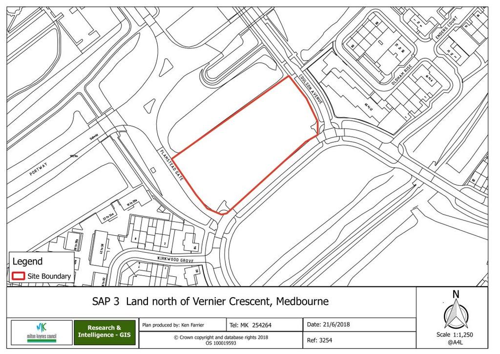
15 SAP 3 - Land north of Vernier Crescent, Medbourne Consultation ref. Area and indicative capacity Previous use Land North of Vernier Crescent, Medbourne U8 0.4Ha - up to 14 dwellings Reserve site Land North of Vernier Crescent, Medbourne 15
16 Key principles Land North of Vernier Crescent, Medbourne i. Proposals should adhere to the principles outlined in Section 4 and Section 5 of the 'Pascal Drive, Medbourne' Development Brief (January 2016). ii. The planted screening between the site and the grid road to the north should be retained in proposals. iii. Demonstrate there is adequate capacity in the foul sewerage network. 16
17 17 4.

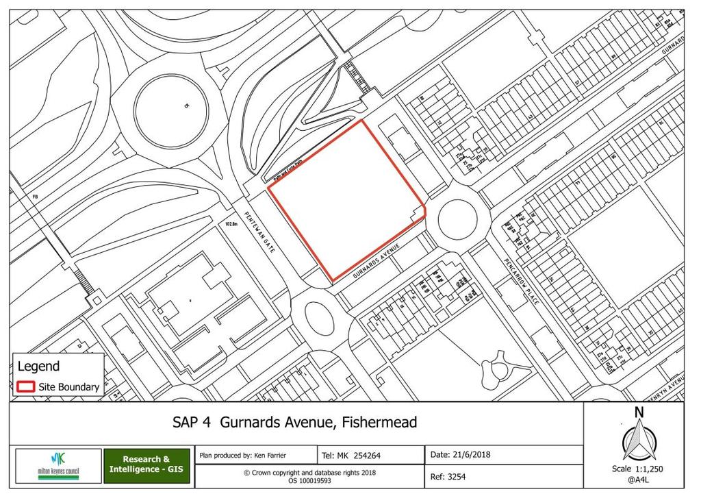
18 SAP 4 - Gurnards Avenue, Fishermead Consultation ref. Area and indicative capacity Previous use Gurnards Avenue, Fishermead U5 0.36Ha - up to 14 dwellings Employment (vacant) Gurnards Avenue, Fishermead 18
19 Key principles Gurnards Avenue, Fishermead i. Development should present an active frontage to all four sides. ii. The redway to the north must be retained in proposals. iii. A higher-density scheme will be acceptable where it can be demonstrated this will not adversely impact the privacy, amenity or light of neighbouring properties. iv. Schemes incorporating some element of mixed use (B1, A1, A2) will be supported. v. Proposals must include provision for play or an equivalent off-site contribution. vi. Demonstrate there is adequate capacity in the foul sewerage network. 19
20 4. 20

21 SAP 5 - Bergamot Gardens, Walnut Tree Consultation ref. Area and indicative capacity Previous use Land at Bergamot Gardens, Walnut Tree U Ha - up to 19 dwellings Allotments (vacant) Land at Bergamot Gardens, Walnut Tree 21
22 Prescribed particulars Land at Bergamot Gardens, Walnut Tree i. Proposals should adhere to principles outlined in Policy WNP 4 of the Walton Neighbourhood Plan, which specifies: Development does not exceed 35 dwellings per hectare (net) (15 units), Development provides an active frontage, where possible, to Bergamot Gardens and the school playing field, Units adjacent to existing residential properties provide acceptable set back distances (minimum 22 metres as specified in the MKC Residential Design Guide) and avoid overlooking, and The proposed design and materials are in keeping with neighbouring properties. This will include the use of red/orange brick construction and dwellings being no more than two and a half storey. 2. Demonstrate there is adequate capacity in the water supply and foul sewerage networks. 22
23 23 4.

24 SAP 6 - Independent school site, Daubeney Gate, Shenley Church End Consultation ref. Area and indicative capacity Previous use Independent school site, Daubeney Gate, Shenley Church End U13 2.5Ha - up to 90 dwellings Education (vacant) Independent school site, Daubeney Gate, Shenley Church End 24
25 Key principles Independent school site, Daubeney Gate, Shenley Church End i. Proposals should incorporate a buffer to the adjacent Scheduled Ancient Monument. ii. Access should be taken from Vache Lane and development should contribute towards appropriate off-site traffic calming measures. iii. Proposals should incorporate measures to improve biodiversity with the western edge of the site left as green space to facilitate this. iv. Dwellings should be orientated to avoid overlooking existing development on Duncan Grove. v. Demonstrate there is adequate capacity in the water supply and foul sewerage networks. 25
26 4. 26

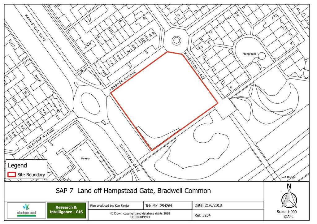
27 SAP 7 - Land off Hampstead Gate, Bradwell Common Consultation ref. Area and indicative capacity Previous use Land off Hampstead Gate, Bradwell Common U3 0.4Ha - up to 16 dwellings Reserve site Land off Hampstead Gate, Bradwell Common 27
28 Key principles Land off Hampstead Gate, Bradwell Common i. Proposals should include provision for play and contributions to improve access to and signposting of formal open space elsewhere in Bradwell Common. ii. iii. iv. Proposals should incorporate on-site parking, not on-street. Higher density or residential-led, mixed-use proposals, containing community facilities, will be acceptable where it can be demonstrated the above principles will not be compromised. Demonstrate there is adequate capacity in the foul sewerage network. v. A sewer and water main crosses this site, therefore the site layout should be designed to take this into account. 28
29 29 4.

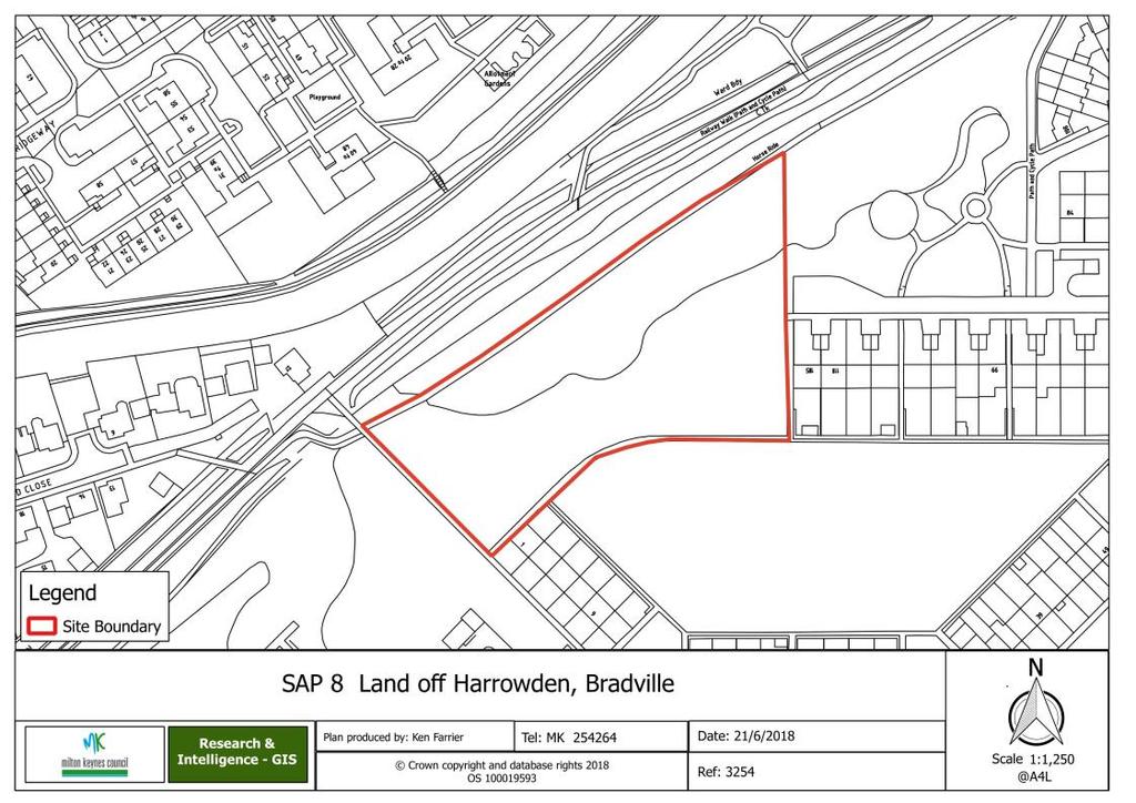
30 SAP 8 - Land off Harrowden, Bradville Consultation ref. Area and indicative capacity Previous use Land off Harrowden, Bradville U Ha - up to 27 dwellings Unused residential allocation Land off Harrowden, Bradville 30
31 Key principles Land off Harrowden, Bradville i. Proposals should reflect the wider regeneration work being undertaken by YourMK in Bradville. ii. Proposals should respect the wildlife corridor on the site s northern edge and include appropriate planting to encourage biodiversity. iii. Demonstrate there is adequate capacity in the water supply and foul sewerage networks. iv. A sewer crosses this site; therefore the site layout should be designed to take this into account. 31
32 4. 32

33 SAP 9 - Timbold Drive, Kents Hill, sites A, C and D1 Consultation ref. Area and indicative capacity Previous use Timbold Drive, Kents Hill, sites A, C and D1 U Ha - up to 228 dwellings Education/commercial (vacant) Timbold Drive, Kents Hill, sites A, C and D1 33
34 Prescribed particulars Timbold Drive, Kents Hill, sites A, C and D1 i. Proposals should adhere to the principles outlined in Section 4 and Section 5 of the 'Kents Hill Park' Development Brief (October 2015). ii. Proposals should be supported by a Transport Assessment that covers the full Kents Hill Park development (including schools) and make junction improvements accordingly. iii. Residential proposals that incorporate an element of C2 use (Residential Institutions) will also be considered appropriate for this site. iv. Demonstrate there is adequate capacity in the foul sewerage network. v. A water main crosses this site; therefore the site layout should be designed to take this into account. 34
35 35

36 SAP 10 - Manifold Lane, Shenley Brook End Consultation ref. Area and indicative capacity Previous use Manifold Lane reserve site, Shenley Brook End U Ha - up to 18 dwellings Reserve site Manifold Lane reserve site, Shenley Brook End 36
37 Key principles Manifold Lane reserve site, Shenley Brook End i. Proposals should respect the community facility adjacent to the site and include appropriate screening for visual and noise mitigation. ii. The planted screening between the site and the grid road should be retained in proposals. iii. Demonstrate there is adequate capacity in the water supply and foul sewerage networks. iv. A water main crosses this site; therefore the site layout should be designed to take this into account. 37
38 4. 38

39 SAP 11 - East of Snelshall Street reserve site, Cranborne Avenue, Westcroft Consultation ref. Area and indicative capacity Previous use East of Snelshall Street reserve site, Cranborne Avenue, Westcroft U Ha - up to 22 dwellings Reserve site East of Snelshall Street reserve site, Cranborne Avenue, Westcroft 39
40 Prescribed particulars East of Snelshall Street reserve site, Cranborne Avenue, Westcroft i. Proposals should adhere to the principles outlined in Section 5 of the 'Westcroft Reserve Site 3' Development Brief (October 2014). ii. Demonstrate there is adequate capacity in the foul sewerage network. iii. A water main crosses this site; therefore the site layout should be designed to take this into account. 40
41 41 4.

42 SAP 12 - Land at Towergate, Groveway, Wavendon Gate Consultation ref. Area and indicative capacity Previous use Land at Towergate, Groveway, Wavendon Gate U17 5.6Ha - up to 147 dwellings Employment (vacant) Land at Towergate, Groveway, Wavendon Gate 42
43 Key principles Land at Towergate, Groveway, Wavendon Gate i. Proposals should adhere to the principles outlined in Policy WNP2 of the Walton Neighbourhood Plan, which states proposals will be supported where: A residential led development is provided which takes account of proposals on the adjacent sites in the Wavendon Triangle that includes the land at Hewlett Packard (WNP 3) and the Fairfields development to the east, Primary access is taken from H9 Groveway, with the main estate road providing connection through to the Fairfields development, Any additional access taken from Ortensia Drive (which will require the Parks Trust's agreement if it crosses Parks Trust parkland) is secondary and provides access to no more than 50 dwellings, Footpath and redway connections are provided to Ortensia Drive, the Fairfields development and the Hewlett Packard site to the south (if developed), The extensive tree belt to the northern and western boundaries of the site are retained, Housing density does not exceed 35 dwellings per hectare (net) across the site, A local centre containing a local shop as a minimum is provided on this site if no shop has been provided in the adjacent land parcels of the Wavendon Triangle, and A Local Equipped Area of Play (LEAP) to be provided on site located a minimum distance of 20 metres from residential boundaries and 30 metres from the nearest road. This should be upgraded to a Neighbourhood Play Area (NEAP) if no NEAP has been approved/provided within the other sites which form the Wavendon Triangle. ii. Demonstrate there is adequate capacity in the foul sewerage network. 43
44 4. 44

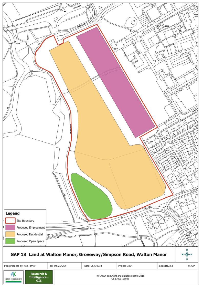
45 SAP 13 - Land at Walton Manor, Groveway/Simpson Road, Walton Manor Consultation ref. Area and indicative capacity Previous use Land at Walton Manor, Groveway/Simpson Road, Walton Manor U Ha - up to 135 dwellings Employment (vacant) Land at Walton Manor, Groveway/Simpson Road, Walton Manor 45
46 Prescribed particulars Land at Walton Manor, Groveway/Simpson Road, Walton Manor i. Proposals should adhere to the principles outlined in Section 4 and Section 5 of the 'Land adjoining Walton Manor, Walton' Development Brief (November 2015), and 'Policy WNP1 Walton Manor' of the 'Walton Neighbourhood Plan (November 2016)'. ii. Demonstrate there is adequate capacity in the water supply and foul sewerage networks. iii. A sewer crosses this site; therefore the site layout should be designed to take this into account. 46
47 47

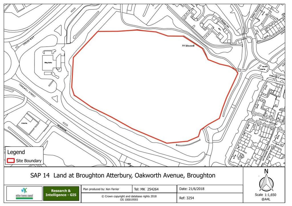
48 SAP 14 - Land at Broughton Atterbury, Oakworth Avenue, Broughton Consultation ref. Area and indicative capacity Previous use Land at Broughton Atterbury, Oakworth Avenue, Broughton U4 4.5Ha - up to 118 dwellings Employment (vacant) Land at Broughton Atterbury, Oakworth Avenue, Broughton 48
49 Prescribed particulars Land at Broughton Atterbury, Oakworth Avenue, Broughton i. Proposals should adhere to the principles outlined in Section 5 of the 'Atterbury Area 1' Development Brief (July 2014) ii. Demonstrate there is adequate capacity in the foul sewerage network. 49
50 4. 50

51 SAP 15 - Land off Ladbroke Grove, Monkston Park Consultation ref. Area and indicative capacity Previous use Land off Ladbroke Grove, Monkston Park U9 0.71Ha - up to 25 dwellings Commercial (vacant) Land off Ladbroke Grove, Monkston Park 51
52 Prescribed particulars Land off Ladbroke Grove, Monkston Park i. Proposals should adhere to the principles outlined in section 5 of the 'Ladbroke Grove, Monkston Park' Development Brief (July 2015). ii. Demonstrate there is adequate capacity in the foul sewerage network. iii. A sewer and water main crosses this site, therefore the site layout should be designed to take this into account. 52
53 53 4.
54 5. Monitoring 5 Monitoring 5.1 The Site Allocations Plan consists of policies for only residential development. Separate monitoring criteria and indicators are therefore not required for the plan. The delivery of each individual allocation will be monitored through the Council's existing procedure for monitoring housing land supply. This consists of maintaining a housing trajectory (in accordance with the National Planning Policy Framework's requirement for a list of specific deliverable sites sufficient to provide five years' supply of housing land). This will be updated quarterly to reflect latest completion rates and any other 'intelligence' that has been gathered by the Council's Joint Housing Monitoring Team. 54
55 . Appendix A Schedule of Superseded Existing Development Plan Policies 6 Appendix A Schedule of Superseded Existing Development Plan Policies 6.1 The below table outlines where existing policy contained within Milton Keynes Council s Development Plan (Milton Keynes Core Strategy (2013) and Milton Keynes Local Plan (2005)) will be superseded by new policy within the Site Allocations Plan as a result of its adoption. SAP Site SAP1 SAP6 Current Development Plan Policy Table 6.1 Local Plan* Policy C9 (Appendix C9 "Reserve Sites)" Local Plan Policy C4 "Education" Amendment Remove site "RS/110/SOC - N of H5 Portway" Delete "Shenley Church End" from list of sites allocated for Independent Schools SAP7 Local Plan* Policy C9 (Appendix C9 "Reserve Sites)" Remove site "RS/2/COML - N of H5 between Hampstead Gate & Wimbledon Place" SAP9 Local Plan Policy C4 "Education" Delete "Kents Hill" from list of sites allocated for Higher Education. SAP10 Local Plan* Policy C9 (Appendix C9 "Reserve Sites)" Remove site "RS/62/SOC - N of H7 Chaffron Way, E of Shenley Brook End Secondary School". SAP11 Local Plan* Policy C9 (Appendix C9 "Reserve Sites)" Remove site "RS/102/SOC - E of V12, Snelshall Street". SAP12 Core Strategy** Policy CS3 "Employment Land Supply" Table 5.4 Amend site area of "Towergate" to 1.5ha, to account for removal of the 5.6ha SAP12 site. SAP13 SAP14 Core Strategy Policy CS3 "Employment Land Supply" Table 5.4 Core Strategy Policy CS3 "Employment Land Supply" Table 5.4 Amend site area of "Walton" to 2ha, to account for removal of 7.5ha for residential and open space use for the SAP13 site Remove reference to "Broughton/Atterbury" from table. 55 * "Local Plan" refers to the Milton Keynes Local Plan (2005) ** "Core Strategy" refers to the Milton Keynes Core Strategy (2013)
Stantonbury Neighbourhood Plan
 Stantonbury Neighbourhood Plan 2018-2031 Basic Conditions Statement October 2018 Intentionally blank 1.0 Basic Conditions Statement Introduction 1.1 This statement has been prepared by Stantonbury Parish
WELCOME GYPSY LANE. Wider Site Location plan. Proposals for the development of LAND OFF FOXLYDIATE LANE WEBHEATH. Proposals for the development of
 WELCOME The developers are preparing an outline planning application for a residential led development and need the community s views in order to develop the proposals further WHAT IS PROPOSED? A high
Description Details submitted pursuant to discharge of condition 5 (Design Code) attached to planning permission 13/01729/OUT.
 attached to planning permission 13/01729/OUT.") ITEM 9 Application Number: 18/00266/DISCON Description Details submitted pursuant to discharge of condition 5 (Design Code) attached to planning permission 13/01729/OUT. AT The Point, 602 Midsummer Boulevard,
ITEM 9 Application Number: 18/00266/DISCON Description Details submitted pursuant to discharge of condition 5 (Design Code) attached to planning permission 13/01729/OUT. AT The Point, 602 Midsummer Boulevard,
BLETCHLEY PARK AREA - DEVELOPMENT FRAMEWORK
 ANNEX A To Item 9 REVISED TEXT: additions shown bold and underlined, deletions in (brackets and in italics). BLETCHLEY PARK AREA - DEVELOPMENT FRAMEWORK This framework sets out the key objectives and requirements
DUNSFOLD NEIGHBOURHOOD PLAN Site Selection Policies
 DUNSFOLD NEIGHBOURHOOD PLAN Site Selection Policies The criteria for assessing sites for future housing and business development in Dunsfold are set out below. (Development criteria, covering what it is
AT Land North And West of Wavendon Business Park, Ortensia Drive, Wavendon Gate
 APP 02 Application Number: 15/02337/OUT Major Outline application for up to 134 residential units, 75-100 sqm of A1 (retail use) for the provision of a local convenience store with access from Ortensia
Public Consultation. Land at Monks Farm, North Grove. Welcome
 Welcome Welcome to our public exhibition for development on Land at Monks Farm, orth Grove. Gallagher Estates and Gleeson Strategic Land are preparing an outline planning application for new homes, open
OKEFORD FITZPAINE NEIGHBOURHOOD PLAN
 OKEFORD FITZPAINE NEIGHBOURHOOD PLAN Dear Parishioner, The Neighbourhood Plan Project Team have prepared this leaflet to summarise the full Neighbourhood Plan document. It provides a summary of the Vision,
Neighbourhood Plan Representation
 Date: 10 th November 2017 Neighbourhood Plan Representation Land to the east of Callow Hill Road, Alvechurch Introduction This representation has been prepared by RPS Planning and Development on behalf
Welcome to our exhibition
 Welcome to our exhibition The Homes & Communities Agency (HCA) welcomes you to this public exhibition explaining our proposals for the redevelopment of the former Lea Castle Hospital site. About the Homes
Report Author/Case Officer: Debbie Kirk Contact Details:
 APP 01 Application Number: 14/00350/OUTEIS MAJOR A residential development for up to 400 dwellings, together with formal and informal open space, amenity space, retained vegetation, structural landscaping,
Newcourt Masterplan. November Exeter Local Development Framework
 Newcourt Masterplan November 2010 Exeter Local Development Framework Background The Exeter Core Strategy Proposed Submission sets out the vision, objectives and strategy for the development of Exeter up
Schedule of Planning Applications Committee Date: 23 May Reference: 06/17/0726/F Parish: Hemsby Officer: Mr J Beck Expiry Date:
 Schedule of Planning Applications Committee Date: 23 May 2018 Reference: 06/17/0726/F Parish: Hemsby Officer: Mr J Beck Expiry Date: 22-05-2018 Applicant: Proposal: Site: Mr Gillett Change of use to the
SOUTH EAST LINCOLNSHIRE LOCAL PLAN: HOUSING PAPER DONINGTON (JUNE 2016)
") SOUTH EAST LINCOLNSHIRE LOCAL PLAN: HOUSING PAPER DONINGTON (JUNE 2016) 1 DONINGTON S PLACE IN THE SPATIAL STRATEGY 1.1 Policy 2 of the South East Lincolnshire Local Plan 2011-2036 Draft for Public Consultation
SOUTH EAST LINCOLNSHIRE LOCAL PLAN: HOUSING PAPER DONINGTON (JUNE 2016) 1 DONINGTON S PLACE IN THE SPATIAL STRATEGY 1.1 Policy 2 of the South East Lincolnshire Local Plan 2011-2036 Draft for Public Consultation
BEDFORD BOROUGH COUNCIL PLAN IMPLEMENTATION MONITORING REPORT
 BEDFORD BOROUGH COUNCIL PLAN IMPLEMENTATION MONITORING REPORT 2017-18 Summary 1 Progress on local development documents 1 Local development documents adopted in the monitoring period 1st April 2017 31st
PHASE III: Reserved Matters Submission
 Statement of Compliance with the outline approval for the proposed residential development of land at: BURGES LANE, WIVELISCOMBE PHASE III: Reserved Matters Submission Foreword Contents: This Statement
Public Consultation 23 January Peel Hall, Warrington Board 1. A message from Satnam... Site history...
 Board 1 A message from Satnam... Thank you for attending today s public consultation about proposals to develop a new residential neighbourhood at. The display boards show why the development is needed
Droitwich Spa 6. Reasoned Justification
 87 Droitwich Spa 6 Reasoned Justification 6.1 Droitwich Spa is identified in the settlement hierarchy (Policy SWDP1) as a main town being the largest settlement in Wychavon District with an estimated population
Key Principles. 290 Phasing Principles and Programme
 4 Phasing principles and programme 4c The aims of the phasing strategy are to satisfy planning policy requirements and create a sustainable, strong and healthy new community where, from the outset, people
Kibworth Harcourt. Introduction. Introduction
 Introduction Introduction Welcome to this public exhibition on the proposals for the delivery of new homes on land at The Kibworths. The purpose of today s exhibition is to give you the opportunity to
STATEMENT OF OBJECTION TO THE PROPOSED DEVELOPMENT OF LAND AT CHURCH CLIFF DRIVE FILEY
 STATEMENT OF OBJECTION TO THE PROPOSED DEVELOPMENT OF LAND AT CHURCH CLIFF DRIVE FILEY You will be aware that Scarborough borough council have adopted a new local plan that includes land at Church Cliff
About 10% of the Borough's population lives in the seven rural parishes. Population figures from the 1991 census are given below:-
 8. THE DISTRICT VILLAGES 8.1 Population About 10% of the Borough's population lives in the seven rural parishes. Population figures from the 1991 census are given below:- Village No. of Persons Cottingham
I615. Westgate Precinct
 I615. Westgate Precinct I615.1. Precinct Description The Westgate Precinct is located approximately 18km west of the Auckland city centre. There are seven Sub-precincts in the Westgate Precinct: Sub-precinct
Neighbourhood Planning Local Green Spaces
 Neighbourhood Planning Local Green Spaces Introduction... 2 1. Why green space is important... 4 2. Neighbourhood plans and green space... 6 3. Evidence... 8 Statutory designations... 9 Green space audit...
Parish of Repton NEIGHBOURHOOD DEVELOPMENT PLAN
 Parish of Repton NEIGHBOURHOOD DEVELOPMENT PLAN BASIC CONDITIONS STATEMENT December 2018 CEF 4 Legal Requirements This statement has been produced by the NDP Working Group on behalf of Repton Parish Council
Derry City and Strabane District Council Planning Committee Report
 Derry City and Strabane District Council Planning Committee Report COMMITTEE DATE: 23 rd March 2016 APPLICATION No: APPLICATION TYPE: PROPOSAL: LOCATION: APPLICANT: LA11/2015/0395/F Residential Development
Reserved Matters application for a site that straddles the boundary between CBC and BBC
 BBC APPLICATION 15/02682/MAR NUMBER CBC APPLICATION CB/15/04294/RM NUMBER LOCATION Wixams Land at former storage depot, Bedford Road, Wilstead Bedfordshire PROPOSAL Reserved Matters Application for Strategic
Suffolk Coastal Local Plan Review Issues and Options, August 2017, Public Consultation
 Suffolk Coastal Local Plan Review Issues and Options, August 2017, Public Consultation Having reviewed the issues and options documents, the Society has made the following response: Part 1 - Strategic
EXTRACT FROM THE CUDDINGTON NEIGHBOURHOOD PLAN The Policies
 EXTRACT FROM THE CUDDINGTON NEIGHBOURHOOD PLAN The Policies Environment and Landscape Policy 1 - Landscape Setting Development should respect and wherever possible enhance the landscape setting of Cuddington
Examination of South Cambridgeshire Local Plan
 Matter SC6A - Policy SS/5 Waterbeach New Town Historic England( formerly English Heritage) 874 Rep Nos 59748, 60250, 60253 Examination of South Cambridgeshire Local Plan Historic England, Hearing Statement
Welcome. Land adjacent Sandy Lane WALTHAM CHASE THE PROPOSED SITE
 Land adjacent Sandy Lane WALTHAM CHASE Existing Linden Homes developments Welcome Welcome to Linden Homes Southern s ( Linden ) public exhibition about its proposals for a range of high-quality homes for
Warren Farm, Ampthill
 1 Welcome The developers of the Warren Farm site, Bloor Homes and Connolly Homes, are holding this exhibition on the emerging Design Codes for the development prior to their formal submission to Central
07/00934/MKPCO OUTLINE PERMISSION FOR RESIDENTIAL DEVELOPMENT OF UP TO 1600 DWELLINGS (35.55 HECTARES), UP TO 3
, UP TO 3") 07/00934/MKPCO AND 07/00936/MKPCO OUTLINE PERMISSION FOR RESIDENTIAL DEVELOPMENT OF UP TO 1600 DWELLINGS (35.55 HECTARES), UP TO 3.14 HECTARES OF MIXED USES (CLASS A1, A2, A3, A4, A5, C3 AND D1 USES INCLUDING
07/00934/MKPCO AND 07/00936/MKPCO OUTLINE PERMISSION FOR RESIDENTIAL DEVELOPMENT OF UP TO 1600 DWELLINGS (35.55 HECTARES), UP TO 3.14 HECTARES OF MIXED USES (CLASS A1, A2, A3, A4, A5, C3 AND D1 USES INCLUDING
Chapter 5 Urban Design and Public Realm
 5.1 Introduction Public realm is all areas of the urban fabric to which the public have access. It is where physical interaction takes place between people. It therefore, includes buildings and their design,
Memorial Business Park Site. Proposed Future Development. Design guidelines. August
 Memorial Business Park Site Proposed Future Development Design guidelines August 2014 www.designenvironment.co.nz 0064 3 358 3040 Contents 1.0 Background 1.1 Introduction 3 1.2 Objectives 4 2.0 Context
Ebbsfleet Development Corporation
 Title of Paper Planning and Housing Delivery Report September 2018 Presented by Sub-Committee Mark Pullin, Chief Planning Officer Planning Committee Purpose of Paper and Executive Summary This paper provides
4 RESIDENTIAL ZONE. 4.1 Background
 4 RESIDENTIAL ZONE 4.1 Background The residential areas within the City are characterised by mainly lowrise dwellings sited on individual allotments. Past architectural styles, settlement patterns and
Derry City and Strabane District Council Planning Committee Report. Amended layout from approval A/2004/0462/F with reduction from 166 units
 Derry City and Strabane District Council Planning Committee Report COMMITTEE DATE: 1 st February 2017 APPLICATION No: APPLICATION TYPE: PROPOSAL: LOCATION: APPLICANT: AGENT: Full Planning application Amended
Statement of Community Involvement LAND OFF SOUTHDOWN ROAD HORNDEAN, HAMPSHIRE
 LAND OFF SOUTHDOWN ROAD HORNDEAN, HAMPSHIRE CONTENTS Page 1. Introduction 3 2. Pre-application Discussions 4 3. The Consultation Process 5 4. Consultation Feedback 7 5. Responses to Consultation Feedback
Variation No 1: Dundalk & Environs Development Plan Core Strategy
 Variation No 1: Dundalk & Environs Development Plan 2009-2015 Core Strategy Adopted on 29 th August 2011 CONTENTS Page Section 1 1.0 Synopsis 1 1.1 Background Document 1 1.2 Variation of Dundalk and Environs
LONGDEN VILLAGE DEVELOPMENT STATEMENT
 LONGDEN VILLAGE DEVELOPMENT STATEMENT 2017-2027 1 Longden Development Statement 2017-2027 15/01/18 1. Background 1.1 Longden Village Longden village is a very rural and traditional community first mentioned
Copyright Nigel Deeley and licensed for reuse under this Creative Commons Licence
 1 Copyright Nigel Deeley and licensed for reuse under this Creative Commons Licence Prepared by the Neighbourhood Plan Steering Group on behalf of Garway Parish Council with assistance from 2 Table of
WINCHESTER TOWN 3.1 LOCATION, CHARACTERISTICS & SETTING
 WINCHESTER TOWN 3.1 LOCATION, CHARACTERISTICS & SETTING 3.1.1 The area referred to by the City Council, as Winchester Town, consists of the Winchester Wards plus the adjoining built up areas of Badger
Plumpton Neighbourhood Development Plan Revised Pre Submission Document - Regulation 14 Consultation
 REPRESENTATIONS... Plumpton Parish Council Plumpton Neighbourhood Development Plan Revised Pre Submission Document - Regulation 14 Consultation Representations submitted on behalf of: Cala Homes (South
Rochford District Council Allocations Development Plan Document: Discussion and Consultation Document Sustainability Appraisal
 Option SWH1 Balanced Communities Option SWH1 1 To ensure the delivery of high quality sustainable communities where people want to live and work Will it ensure the phasing of infrastructure, including
Harrow Lane, St Leonards-on-Sea, East Sussex, TN37 7JZ ERECTION OF 113 DWELLINGS TOGETHER WITH ESTATE ROADS (DETAILED SUBMISSION)
") AGENDA ITEM NO: Report to: PLANNING BOARD Date: 10 September, 2003 Report from: Borough Planning Officer Application Address: Proposal: Application No: Recommendation: Ward: File No: Applicant: Interest:
AGENDA ITEM NO: Report to: PLANNING BOARD Date: 10 September, 2003 Report from: Borough Planning Officer Application Address: Proposal: Application No: Recommendation: Ward: File No: Applicant: Interest:
3.1 The hybrid planning application proposes the following description of development:
 CHAPTER 3: PROPOSED DEVELOPMENT 3.1 The hybrid planning application proposes the following description of development: Hybrid (part-outline/part-full) planning application for a single composite development
Report Author/Case Officer: Joanne Horner Contact Details:
 APP 04 Application Number: 16/00140/FUL Other Two storey side extension to existing dwelling and formation of hard standing to provide parking for number 54 (Resubmission of withdrawn application 15/02852/FUL)
Report Author/Case Officer: Paul Keen Senior Planning Officer (Dev Control) Contact Details:
 Contact Details:") APP 03 Application Number: 17/02060/FUL Description A full planning application for the demolition of an existing bungalow (C3 use class) and associated out buildings and the erection of two, two storey
APP 03 Application Number: 17/02060/FUL Description A full planning application for the demolition of an existing bungalow (C3 use class) and associated out buildings and the erection of two, two storey
Plumpton Neighbourhood Plan Site Assessment Report
 Plumpton Neighbourhood Plan Site Assessment Report May 2016 1 Contents 1. Introduction 3 2. Methodology 4 2.1 Identification of Potential Sites 4 2.2 Assessment Process 5 2.3 Assessment Criteria 6 2.4
an Inspector appointed by the Secretary of State for Communities and Local Government
 Appeal Decision Site visit made on 11 October 2016 by Mike Hayden BSc DipTP MRTPI an Inspector appointed by the Secretary of State for Communities and Local Government Decision date: 21 November 2016 Appeal
Sustainability Statement. Whitby Business Park Area Action Plan
 Sustainability Statement Whitby Business Park Area Action Plan November 2014 Contents Page 1. Introduction 1 2. Scoping 3 3. Sustainability Appraisal of Options 6 4. Assessment of Draft Area Action Plan
ROCHFORD LOCAL DEVELOPMENT FRAMEWORK: Sustainability Appraisal/ Strategic Environmental Assessment. Rochford Core Strategy Preferred Options Document
 ROCHFORD LOCAL DEVELOPMENT FRAMEWORK: Sustainability Appraisal/ Strategic Environmental Assessment Non Technical Summary Rochford Core Strategy Preferred Options Document October 2008 SUSTAINABILITY APPRAISAL
Application Recommended for Approval Hapton with Park Ward
 Application Recommended for Approval Hapton with Park Ward APP/2017/0036 Outline Planning Application Outline application for the construction of a new 3 bedroom dwelling (with all matters reserved for
Land at Pirton Fields. South Churchdown, Innsworth Design and Access Statement Addendum
 Land at Pirton Fields South Churchdown, Innsworth Design and Access Statement Addendum February 2017 Revisions Revision Date Description Prepared Approved Document No. 15-45-CR02 - Land at Pirton Fields
Blandford Forum Town Council, Blandford St Mary Parish Council and Bryanston Parish Council
 Blandford Forum Town Council, Blandford St Mary Parish Council and Bryanston Parish Council Blandford + Neighbourhood Plan 2 Pre-Submission Plan Consultation (November 2018) Representations submitted on
A. The sites in Table 16 below, as identified on the Policies Map, are allocated for retail-led development:
 SWDP 44: Worcester City Centre A. The sites in Table 16 below, as identified on the Policies Map, are allocated for retail-led development: Table 16: Sites Allocated for Retail-Led Development Policy Reference
Proposed Student Accommodation Development
 Statement of Response to the Notice of Pre- Application Consultation Opinion Former "Matts of Cabra" public house and lands to the rear, Fassaugh Avenue, Cabra, Dublin 7 Proposed Student Accommodation
Welcome to our public exhibition
 About our development Welcome to our public exhibition This exhibition gives you the chance to view and comment on our proposals for a new residential development of 165 high-quality homes, along with
Briefing Document of CNP. June 2017
 Cholsey Parish Council Cholsey Neighbourhood Plan Briefing Document of CNP June 2017 Cholsey Neighbourhood Plan Page! 1 of! 8 Cholsey Plan Briefing v1.4 Page Left Intentionally Blank Cholsey Neighbourhood
INTRODUCTION NORTH HEYBRIDGE GARDEN SUBURB
 INTRODUCTION This event is being hosted by the promoters of the proposed North Heybridge Garden Suburb who are working with Maldon District Council and other key stakeholders on the preparation of a comprehensive
WELCOME TO THE NEW WILTON PARK
 WELCOME TO THE NEW WILTON PARK VISION HISTORY OF WILTON PARK TOWARDS A PLANNING APPLICATION Our objective is to create a truly outstanding environment at Wilton Park. At the heart of our proposals is a
Ipswich Issues and Options for the Ipswich Local Plan Review, August 2017, Public Consultation
 Ipswich Issues and Options for the Ipswich Local Plan Review, August 2017, Public Consultation Having reviewed the issues and options documents, the Society has made the following response: Part 1 Strategic
Planning and Sustainability Statement
 Land adjacent to Manor Farm, Catterick Village Pallett Hill Sand and Gravel Co Ltd Proposed 10 new dwellings, (6 No market dwellings and 4 No affordable dwellings) with access, associated car parking and
GREENFORD HALL & ADJOINING LAND
 GREENFORD HALL & ADJOINING LAND CONTENTS 1. Introduction 1. Introduction 2. Urban Context 2.1 The Site and Surroundings 2.2 Urban Context Map 2.3 Access and Movement 3. Planning Context 3.1 Planning History
Built Up Area Boundary (BUAB)
") Parish Boundary Built Up Area Boundary (BUAB) Potential Sites Map not to scale DWELLING SIZE POLICY Residential developments must provide a mix of dwelling sizes (market and affordable) that reflect the
Parish Boundary Built Up Area Boundary (BUAB) Potential Sites Map not to scale DWELLING SIZE POLICY Residential developments must provide a mix of dwelling sizes (market and affordable) that reflect the
Site Assessment Technical Document Appendix A: Glossary
 Central Bedfordshire Council www.centralbedfordshire.gov.uk Site Assessment Technical Document Appendix A: Glossary July 2017 1.1.11-1 - ii Appendix A: Glossary Term Agricultural Land Classification AONB
Perth and Kinross Council Development Management Committee 8 June Pre-Application Report by Development Quality Manager
 Perth and Kinross Council Development Management Committee 8 June 2016 5(3)(i) 16/259 Pre-Application Report by Development Quality Manager Residential development at St Martins Road, Land 120 metres West
INTRODUCTION. Land south of Bishopswood Lane, Tadley
 0 INTRODUCTION THE SITE Introduction Gladman Developments Ltd. has successfully invested in communities throughout the UK over the past 0 years, developing high quality and sustainable residential, commercial
DESIGN & ACCESS STATEMENT
 DESIGN & ACCESS STATEMENT January 2016 Contents Introduction section 1 Section 1 - Introduction Section 2 - Assessment Section 3 - Involvement Section 4 - Evaluation Section 5 - Design Section 6 - Layout
8.0 Design and Form of Development 43/
 42/ 8.0 Design and Form of Development 43/ Rothwells Farm, Golborne/ Development Statement Figure 7. Site Constraints Key 44/ Site Boundary 360 Bus Route/Stops Existing Trees Underground Water Pipe Sensitive
3. Neighbourhood Plans and Strategic Environmental Assessment
 1. Introduction This report sets out a draft Screening Determination for the Preston Parish Council s Neighbourhood Plan and has been prepared by rth Hertfordshire District Council. The purpose of the
PLANNING STATEMENT (INCLUDING HOUSING, AFFORDABLE HOUSING STATEMENT AND SUSTAINABILITY STATEMENT) TO ACCOMPANY AN OUTLINE PLANNING
 TO ACCOMPANY AN OUTLINE PLANNING") PLANNING STATEMENT (INCLUDING HOUSING, AFFORDABLE HOUSING STATEMENT AND SUSTAINABILITY STATEMENT) TO ACCOMPANY AN OUTLINE PLANNING APPLICATION FOR THE DEVELOPMENT OF UP TO 230 DWELLINGS; CLASS B1 BUSINESS
PLANNING STATEMENT (INCLUDING HOUSING, AFFORDABLE HOUSING STATEMENT AND SUSTAINABILITY STATEMENT) TO ACCOMPANY AN OUTLINE PLANNING APPLICATION FOR THE DEVELOPMENT OF UP TO 230 DWELLINGS; CLASS B1 BUSINESS
Repton Parish Neighbourhood Development Plan - Consultation March 2017
 Repton Parish Neighbourhood Development Plan - Consultation March 2017 25 replies Policy No Comments Response H1 Agree 22 Amend to include Milton Road & footpath but exclude above footpath. Neither agree
WHITELEY TOWN COUNCIL NORTH WHITELEY DEVELOPMENT SEPTEMBER 2014
 WHITELEY TOWN COUNCIL NORTH WHITELEY DEVELOPMENT SEPTEMBER 2014 Dear Resident This Special Edition of the Whiteley Voice which has been prepared in conjunction with the North Whiteley Consortium is to
Chapter 2: OUTLINE PLANNING APPLICATION PROPOSALS. A New Garden Neighbourhood Matford Barton 17
 Chapter 2: OUTLINE PLANNING APPLICATION PROPOSALS A New Garden Neighbourhood Matford Barton 17 2.1. SUMMARY AND STATUS OF THE PROPOSALS 2.1.1. The parameter plans and associated wording in this chapter
South Worcestershire Development Plan. South Worcestershire Design Guide Supplementary Planning Document
 South Worcestershire Development Plan South Worcestershire Design Guide Supplementary Planning Document Statement of Consultation: Early Engagement Scoping Paper February 2017 1. Introduction 1.1 This
APP/G1630/W/15/
 Appeal Decision Site visit made on 20 October 2015 by William Fieldhouse BA (Hons) MA MRTPI an Inspector appointed by the Secretary of State for Communities and Local Government Decision date: 20 November
Site ref: AS06 Site Name or Address: Murreys Court, Agates Lane
 Site ref: AS06 Site Name or Address: Murreys Court, Agates Lane Proposed Land Use: Total Site Area (Ha): Housing 1.85 Ha Description: It is understood that the owner has no plans to dispose of the site
The Fairfield Partnership Vision for North-East Elsenham
 The Fairfield Partnership Vision for North-East Elsenham August 2009 Frequently Asked Questions Who is The Fairfield Partnership? The Fairfield Partnership is a joint venture between Marchfield Developments
WELCOME. North East Haverhill. The Planning Process
 WELCOME North East The site to the North East of, known as Great Wilsey Park, is identified by St Edmundsbury Borough Council in its Core Strategy as capable of delivering a Sustainable Urban Extension.
Linby Neighbourhood Plan Masterplan Safeguarded Land Top Wighay Farm March Linby Neighbourhood Development Plan Masterplan 1
 Linby Neighbourhood Plan Masterplan Safeguarded Land Top Wighay Farm March 2017 Linby Neighbourhood Development Plan Masterplan 1 Linby Neighbourhood Development Plan Masterplan 2 Contents: Section 1:
SPG 1. * the northern and western sections which are open fields used for pasture and grazing;
 SPG 1 1.0 INTRODUCTION This development brief is based on the allocation of the Priors Hall site for employment and countryside recreational purposes in the Corby Borough Local Plan. The brief is intended
LAND USE AMENDMENT CORNERSTONE (WARD 3) 60 STREET NE AND COUNTRY HILLS BOULEVARD NE MAP 26NE BYLAW 22D2017
 60 STREET NE AND COUNTRY HILLS BOULEVARD NE MAP 26NE BYLAW 22D2017") Page 1 of 14 EXECUTIVE SUMMARY This Land Use Amendment application covers an area of 43.76 hectares ± (108.14 acres ±) located in northeast Calgary, bound by Country Hills Boulevard NE to the south and
Page 1 of 14 EXECUTIVE SUMMARY This Land Use Amendment application covers an area of 43.76 hectares ± (108.14 acres ±) located in northeast Calgary, bound by Country Hills Boulevard NE to the south and
13 THORNHILL YONGE STREET STUDY IMPLEMENTATION CITY OF VAUGHAN OPA 669 AND TOWN OF MARKHAM OPA 154
 13 THORNHILL YONGE STREET STUDY IMPLEMENTATION CITY OF VAUGHAN OPA 669 AND TOWN OF MARKHAM OPA 154 The Planning and Economic Development Committee recommends the adoption of the recommendations contained
North Oakville East Parks Facilities Distribution Plan. November, 2009
 North Oakville East November, 2009 POLICY CONTEXT 1) Purpose a) The purpose of this document is to be a guide for the location, configuration, design and development of the parks system for the North Oakville
7.1.6 The main components of the development strategy for Hertford are as follows:
 Chapter 7 Hertford 2 Chapter 7 Hertford 7.1 Introduction 7.1.1 The County town of Hertford lies at the confluence of four rivers in a valley setting, which in the past has influenced its shape and form.
SUB AREA 3 CENTRAL STRATFORD AND SOUTHERN QUEEN ELIZABETH OLYMPIC PARK
 191 ADOPTED LOCAL PLAN: THE SUB AREAS SUB AREA 3 CENTRAL STRATFORD AND SOUTHERN QUEEN ELIZABETH OLYMPIC PARK SECTION 12 Vision VISION Central Stratford and Southern Queen Elizabeth Olympic Park will become
an Inspector appointed by the Secretary of State for Communities and Local Government
 Appeal Decision Site visit made on 23 January 2017 by Gareth Wildgoose BSc (Hons) MSc MRTPI an Inspector appointed by the Secretary of State for Communities and Local Government Decision date: 6 February
SECOND DRAFT ARMTHORPE NEIGHBOURHOOD DEVELOPMENT PLAN AUGUST 2014
 SECOND DRAFT ARMTHORPE NEIGHBOURHOOD DEVELOPMENT PLAN AUGUST 2014 ARMTHORPE NEIGHBOURHOOD DEVELOPMENT PLAN August 2014 Contents Copyright Armthorpe Parish Council 2014 Introduction... 4 Vision and Aims...
Welcome to our public exhibition
 About Our Scheme Welcome to our public exhibition This exhibition gives you the chance to view and comment upon our emerging proposals for a new residential development of 68 new homes on the site of the
SOUTH CAMBRIDGESHIRE DISTRICT COUNCIL. Executive Director (Operational Services) Corporate Manager (Planning and New Communities)
 Corporate Manager (Planning and New Communities)") SOUTH CAMBRIDGESHIRE DISTRICT COUNCIL REPORT TO: Planning Committee 12 January 2011 AUTHOR/S: Executive Director (Operational Services) Corporate Manager (Planning and New Communities) Notes: S/1848/10
SOUTH CAMBRIDGESHIRE DISTRICT COUNCIL REPORT TO: Planning Committee 12 January 2011 AUTHOR/S: Executive Director (Operational Services) Corporate Manager (Planning and New Communities) Notes: S/1848/10
1. Welcome. Background
 1. Welcome The purpose of this exhibition is to provide you with an update on progress on the Kilnwood Vale Scheme. In order to improve the scheme and deliver key facilities earlier in the development,
19 th October FAO Paul Lewis Planning Policy Branch Planning Division Welsh Assembly Government Cathays Park Cardiff CF10 3 NQ
 19 th October 2009 FAO Paul Lewis Planning Policy Branch Planning Division Welsh Assembly Government Cathays Park Cardiff CF10 3 NQ Dear Sir / Madam Technical Advice Note 6 Planning for Sustainable Rural
RYEDALE SITES LOCAL PLAN MATTER 3 HOUSING ALLOCATION SITE REF.SD5 LAND EAST OF WHITBY ROAD, PICKERING DAVID WILSON HOMES REPRESENTOR ID: 1073
 RYEDALE SITES LOCAL PLAN MATTER 3 HOUSING ALLOCATION SITE REF.SD5 LAND EAST OF WHITBY ROAD, PICKERING INTRODUCTION DAVID WILSON HOMES REPRESENTOR ID: 1073 1.1 We write on behalf of our client David Wilson
2A District-wide Policies
 2A Introduction This Chapter contains policies which are relevant to subdivision, use and development activities occurring across all zones and areas of the District. The policies in this Chapter implement
D4.4N Site, CMK Planning Brief
 D4.4N Site, CMK Planning Brief Adopted June 2013 (Updated March 2017) D4.4N Site, CMK Planning Brief This document has been prepared by Milton Keynes Council s Urban Design and Landscape Architecture Team
Appendix 1 Structure plan guidelines
 Appendix 1 Structure plan guidelines This appendix forms part of the regional policy statement [rps]. 1.1. Introduction Structure plans are an important method for establishing the pattern of land use
Evesham 7. Reasoned Justification
 95 Reasoned Justification 7.1 Evesham is situated within the Vale of Evesham and has an estimated population of 22,800 (2009 Mid-Term Population Estimates). As a main town it provides a wide range of services
9 Pershore. Introduction. Pershore Abbey
 118 Introduction 9.1 The historic town of Pershore lies on the River Avon and has a population of 7,000 (2009 Mid-Term Population Estimates). The main areas of the town are centred on the Abbey, the bustling