Simpson Shaw Surveyors
|
|
|
- Helena Lindsey
- 5 years ago
- Views:
Transcription

1 \ t Simpson Shaw Surveyors Resource Managers APPLCATON for Resource Consent: 4 DP Whangarei District Plan Prepared for: Colonel Holgate Estate Date: September 2016 File: 15097
2 Application Application Title: Plan ,, 8 subdivision 751 Ngunguru Road July 2016 Colonel Holgate Estate Reference j TABLE OF CONTENTS 10 NTRODUCTON 4 11 Report Basis 4 12 Applicant and Property Details 4 12 Site History 5 13 Site Description 5 20 SUBDVSON SPECFCS 6 21 Proposal 6 22 Earthworks & Staging, Roading & Access 6 23 Services 6 24 Reserves 7 25 WDC Proposed Planning Proposed Rural production 7 30 DSTRCT PLAN 7 31 General Assessment 7 32 Assessment Countryside Environment Rules 7 33 Assessment Road Traffic Rules 9 34 Assessment Activity Rules and Building Rule Table 9 35 Resource Area Rule 63 Contaminated Sites Rule ASSESSMENT OF ENVRONMENTAL EFFECTS ASSESSMENT OF OBJECTVES AND POLCES Overview Objectives and Policies MATTERS TO BE CONSDERED AS REQURED BY RMA Part Assessment Analysis of section OTHER PLANNNG DOCUMENTS ASSESSMENT New Zealand Coastal Policy Statement OTHER MATTERS Consultation and Public Notification Development Contributions Amalgamation Condition CONCLUSON APPENDX Appendix A 25 Plan EA Sheets 1 & 2 Plan (with aerial) EB DP Simpson Shaw Surveyors 2
3 Locality Current Whangarei Whangarei Whangarei Whangarei WDC Quattro \, 8 subdivision Colonel Holgate Estate 751 Ngunguru Road Sept 2016 Reference Appendix B 26 Map Whangarei District Council GS Map with aerial Photo Appendix C 27 District Council Operative Resource Map 7 District Council Operative Environment Map 7 District Council Proposed Resource Map District Council Proposed Environment Map 7 Appendix D 28 Correspondence with Northland Regional Council regarding HAL records Contaminated Site Search Report Appendix E 29 Subdivision Suitability Report Engineering Ltd Appendix F 30 Photos of the development of Col Holgate Estate Appendix G Additional information requested 31 Assessment against the objectives and Policies of the plan Consent Notice Proposed right of way users Simpson Shaw Surveyors 3
4 , 8 subdivision Colonel Holgate Estate 751 Ngunguru Road Sept 2016 Reference J 1 NTRODUCTON 11 Report basis 111 This report has been prepared for Colonel Holgate Estate in support of an application, for Resource Consent in respect of property located on 751 Ngunguru Road t has been prepared in accordance with the provisions of Section 88 of the Resource Management Act, 1991 (The Act) 112 Section 88 of the Act requires each Resource Consent application to be accompanied by an Assessment of Environmental Effects, (AEE) which outlines the actual or potential effects the proposed activity has on the environment, and the ways in which any adverse effects may be mitigated The assessment is also expected to cover various related matters listed in the Fourth Schedule to the Act, including a description of the proposal, consultation with interested parties and monitoring APPLCANT AND PROPERTY DETALS Address: 751 Ngunguru Road Applicant s Names Col Holgate Estate Address for Service: Simpson Shaw Surveyors PO Box 631 Whangarei Attention: Trevor Shaw Pat Smith Legal Description: 4 DP Site Area ha District Plan and Zoning: Operative Whangarei District Council District Plan Map 7E shows the subject site as Countryside Environment Proposed Environment Whangarei District Council District Plan Map 7E shows the area as Proposed Rural Production Environment, Designations/limitations: The Operative and the Proposed Whangarei District Council District Resource Map No 7R shows there are no council identified hazard features depicted on the subject site 12 Site History A previous subdivision (initiated in 2001) created five lots in DP399566; 4 DP is the subject lot of the proposed subdivision The proposed subdivision will create six additional lots as shown in the subdivision scheme plan E1 (Simpson Shaw), which is included in Appendix A Simpson Shaw Surveyors 4
5 , " \ 8 subdivision Colonel Holgate Estate 751 Ngunguru Road Sept 2016 Reference Site Description The subject land is located on the northern side of Ngunguru Road, approximately 15km from Whangarei central The land is of variable contour that generally slopes from Ngunguru Road down towards the Ngunguru River which forms the Northern boundary 4 was part of an original subdivision undertaken in 2001 This application is to subdivide 4 DP and is the proposed Stage 2 of the original subdivision lot 4 DP CFR ha 113 The subject land has an existing dwelling onsite This house is serviced with a garage and a number of small sheds on the subject (Proposed 2) DP is predominantly in grass with a large area of trees towards the Ngunguru River 115 Ngunguru Road is the legal road adjacent to the proposal The access to the subject lot was upgraded to meet the requirements of both stages The access to the existing house from the road boundary is via a formed access over the pan handle strip that is part of 4 DP See attached survey plan DP in Appendix A 116 The house has an existing telecommunications & power connection t also has existing onsite water supply & the overland flow paths that control any stormwater The house is serviced by an existing onsite wastewater system 117 The Right of Way was constructed as part of Resource Consent SD The engineering plans show that the Rights of Way were designed with a surface width of 40m and an overall carriageway width of 45m (See Appendix F) ~~J Myponcill~>>nlyOrl" O,,,yNHannDn ~ ~~~"""" H ~!","!~: Locality Map Simpson Shaw Surveyors 5
6 , 8 Let subdivisien Celenel Helgate Estate 751 Ngunguru Read Sept 2016 Reference ) 20 SUBDVSON SPECFCS 21 Proposal This prepesal censists of an 8 let subdivisien that will create 5 additienal building sites The Applicatien planof the proposed subdivision is referenced in Appendix A E1 drawing The details are listed below Appellation Lot 1 Lot 2 Lot 3 Lot4 Lot 5 Lot 6 Lot 7 Lot 8 Area 141 ha 149ha 161 ha O4ha 066ha 054ha 113ha Esplanade Reserve Proposed Title CFR CFR CFR CRF CFR CFR to vest m 1:n"" _n_ "_2 _ e> ~~~~~ R = r:_o::!lagl J_ = ) 1 afl D 22 Earthworks Earthworks will be required to create the formation of the access to the new lots and the services to these Lots This is not anticipated to be significant as the access formation will be consistent with the topography of the land Roading & Access Ngunguru Road is the legal road adjacent to the proposal The vehicle access onto Ngunguru Road was upgraded as part of the previous subdivision and will not require any further development as it meets the WDC EES 2010 standards The additionallots will access onto Ngunguru Road via Easement J on the Application plan EB Simpsen Shaw Surveyors 6
7 (Spathodea,, Map, \ \ 8 subdivision 751 Ngunguru Road Sept 2016 Colonel Holgate Estate Reference Services 231 The dwellings will all have their own telecommunications & electricity connections They will also have their own onsite water t is proposed the dwellings also will be serviced with an onsite wastewater system 232 Firefighting water tanks will be required at building stage 24 Reserves & Land Covenants 241 As part of the previous subdivision a number of tree protection covenants were created The Esplanade Reserve ( 8) will be vested as part of this application t is also proposed that a Tree Protection Convent on 2 will be created to protect the African Tulip Tree campanulata) 242 Area marked J in 1 is subject to a Consent Notice 25 WDC Future Proposed Planning See Appendix G Proposed Rural Production Environments Council is introducing new Environments into the previous Countryside Environment zoning n this case the proposed Environment map shows the area as Proposed Rural Production Rural Production has been identified as an area that will provide for a variety of Rural Living opportunities in the District without materially reducing the potential of the Rural Area for productive use of the land The property is not currently a viable economic unit and the resulting titles can be expected to be more productive n this instance, the Underlying Environment is Countryside Any subdivision of less than 20ha does not comply with the conditions of a controlled activity 30 DSTRCT PLAN 31 General 311 The subject lots are situated in the Countryside Environment No 7 (Refer Environments Map Appendix C) The lots are not subject to any notations identified on the Resource Area Map No 7 within the Whangarei District Council District Plan (Refer Resource Map Appendix C) 32 Assessment against 733 Environment Rules Countryside Environment Rule Status Comment 7331 Allotment Area Noncomplying The s are under the 20ha area required under this rule for the activity to be classed as a controlled activity The development is consistent however with the development density of the previously approved Stage Building Area Controlled 2 has an existing dwelling and onsite services s 1, 36 have Simpson Shaw Surveyors 7
8 8 subdivision Colonel Holgate Estate 751 Ngunguru Road Sept 2016 Reference j buildable areas See the Application Plan 7335 Existing Buildings Controlled 2 has existing buildings All new boundaries have been placed to comply with the requirements of the District plan 7336 Sites of Significance Controlled No sites of significance have been to Maori identified on the planning maps 7337 Property Access Controlled Each allotment is capable of vehicle access from Ngunguru Road via the easements 7338 Vehicle Crossings Controlled The lots will access Ngunguru Road via the one vehicle access over easement AJ 7339 Road Formation Controlled No new roads are proposed as part of this application Provision for Controlled The design & layout of the proposal Extension of Services allows the existing services and access to be used Services will be extended to the new s Water Supply Controlled t is proposed that the lots in this proposal will have onsite water collection systems Stormwater Controlled Due to the topography of the site, the stormwater is disposed of via existing overland flowpaths s 1, 3 6 will require stormwater attenuation as they are under 1 ha and are undeveloped 2 is already developed and therefore does not require any further attenuation Sewage Controlled t is proposed that the new lots will have onsite wastewater systems 2 has an existing system within the proposed boundaries As stated in the Engineering Report by Quattro Engineering Ltd dated 9 July 2016 The proposed s 1, 3, 4, 5 & 6 will require onsite waste water management systems refer Appendix E Electricity Controlled Each will have its own connection to the network Telecommunications Controlled Each will have its own connection to the network Earthworks Controlled All proposed earthworks will comply with the WDC EES Other Significant Controlled There are no significant or notable Features features shown on the WDC Resource Area Map 7 & 12 Simpson Shaw Surveyors 8
9 , Building " \ 8 subdivision Colonel Holgate Estate 751 Ngunguru Road Sept 2016 Reference Assessment against Road Traffic Rules Rule Status Comment 4721 Parking & Loading Permitted The new lots will have adequate parking and the ability to reverse out of the parks without encroaching on other lots or riqhts of way 4724 Onsite Manoeuvring Permitted Due to the size of the lots, there is more than adequate room for onsite manoeuvring Engineering Permitted All required engineering works will be Standards completed to comply with the WDC Environmental Engineering Standards Assessment against Countryside Environment Tables The rules as set out in Section 383 Countryside Environment Section 384 Countryside Environment Rule Tables: Activity Rules and Building Rule Activity Rule Tables and Rule Status Comment 3835 Provision of Parking Spaces Permitted All s in this proposal will have 3836 Traffic Movements Permitted suitable parking in accordance with Chapter 47 There will be 6 additional s created as a result of this subdivision Although one of those ( 7) will be jointly owned and will not have a dwellinq built on it 3841 Residential Units Permitted Each new lot will have no more than one residential unit contained within it with the exception of 7 will not have a residential unit dwellinq 3842 Minor Residential Units Permitted There are no minor residential units prodosed as part of this application 3844 Building Coverage Permitted 2 has existing buildings within its proposed Boundaries These are well under the 500m2 reauired in the District Plan 3845 Building Setbacks Permitted The 2 boundaries are set back the required distances from all existina buildings 3847 Building to Access Setbacks Permitted All new access boundaries are designed to be set back, the required distances from all existina buildinqs Building Daylight Angles Permitted The Buildings on 2 do not infringe on the daylight angles requirement Simpson Shaw Surveyors 9
10 ~ ~ J, 8 subdivision Colonel Holgate Estate 751 Ngunguru Road Sept 2016 Reference J Comment: No construction or alteration of residential buildings will be required as part of this proposal The application complies with all the above rules except minimum lot size However, it is consistent with other development in the area 35 Resource Area Rule 63 Contaminated Sites Rule As a portion of this land will be changing from Rural Production use to Residential, a preliminary site investigation has been undertaken into the history of the site to determine if any HAL activities have taken place to determine if any of the proposed residential land is at risk of being contaminated t has been found that it is highly unlikely for this site to be contaminated and the preliminary site investigation is attached in Appendix O A request for WOC staff to search the Council records resulted that there was no record of contamination on the site The request to the NRC records indicated the same result See Appendix O 40 Assessment of Environmental Effects r ssue being Effectls on: Magnitude Assessed: Of Effectls: r Other Comments Vegetation Biodiversity Nil The proposal does not require Visual the removal of any significant landscape trees or vegetation and there are no significant areas of indigenous flora or fauna that would be adversely affected Ecology Minor The lots are located on existing farm grassland Any areas that have ecological significance have been set aside due to this proposal This land will change from Countryside (Rural Production) to Rural Residential The remainder of the underlying land will be incorporated into 7 which consists predominately of Native bush There are no proposed changes to the more sensitive ecological areas and as such the plant and animal species located in these areas are types that exist in, or have adapted to, this environment Landform As of right The site has a natural topography that is well suited to the proposed development The Landscape is elevated but does not rise above the ridgeline The proposed dwellings maybe seen from the paddocks to the east but the dwellings are able to be well concealed Stormwater Runoff Environment Minor There will be increased stormwater runoff from this subdivision due to the increase Simpson Shaw Surveyors 10
11 , " " 8 subdivision Colonel Holgate Estate 751 Ngunguru Road Sept 2016 Reference in impervious areas t must be noted that roof water will be collected in onsite tanks for water supply The engineering report notes the need for storm water management t is proposed that the action outlin~d within the recort be undertaken Sediment Environment Minor t is not anticipated that the post Runoff development sediment runoff will be any higher than it currently is now During construction, the biggest risk of sediment runoff is from the construction of the rights of ways However, by timing the works to the drier parts of the year and implementing sound construction stormwater controls, the effects of these can be minimised Capacity of Minor There is no public Foul Sewer Public Utility System operating in the area Systems This applicant is proposing that all s will have approved onsite wastewater systems Water Supplv There is no public reticulated water supply within the area t is proposed that the lots will be serviced by onsite roof water capture and contamination systems Stormwater There is no piped public stormwater network on Ngunguru Road There will be an increase in impervious surfaces but this will be offset by the fact that roof water will be collected for water supply and adequate design for attenuation will be undertaken Flooding Nil The site is well elevated with the sections on sloping ground meaning there is very little risk of flooding Furthermore, The WDC Resource Maps do not identify anv areas as b~ina flood crone Character Environment More than Minor This development is in keeping And Views with the character of the surrounding area The proposal is unique and prestigious Simpson Shaw Surveyors 11
12 current ~ < 8 subdivision Colonel Holgate E$tate 751 Ngunguru Road Sept 2016 Reference f Natural Nil The District Plan Resource Area Heritage Maps do not identify any Natural Features Heritage Features on or in close proximity to the site Manmade Nil Records from the Whangarei Heritage District Council and The NZ Structures Archeological Association do not identify any Archeological sites on site The property had existing rock walls and the owner has had more constructed These are protected by the District Plan Cultural Nil There are no known Values archaeological sites or taonga or wahi tapu on the site or within vicinity to the site that are shown on Council maps There is no reason to consider Smell Air Nil that the proposal will result in Discharges the generation of smell Noise Minor t is not expected that this proposal will generate a significant increase in noise Any such noise will be no more than is anticipated under the District Plan rules and therefore can be carried out as of right Vibration Minor There may be some minor ground vibration during the formation of the rights of way By limiting this construction to working hours and noise levels below the permitted threshold these effects can be minimized Soil Stability Minor An engineering report by Quattro Engineering Ltd shows that lots 1 6 have suitable building areas Refer Appendix E Hazardous Nil The development is not Substances or nstallations associated with any hazardous substances or installations Contaminants Nil No contaminants are associated with this development Reverse Minor The landuse areas to the east Sensitivity and west f the subject site consist of rural farm lands which are permitted activities within the Simpson Shaw Surveyors 12
13 , \ 8 subdivision Colonel Holgate Estate 751 Ngunguru Road Sept 2016 Reference zone The existing use will not alter as a result of the consent to this application and will not result in any reverse sensitivity issues Driver General Minor There will be additional traffic Pedestrian Environment generated from the 6 additional Safety titles resulting from this proposal Only 5 of those are designed to have dwellings Archaeology Nil There are no recorded archaeological sites or scientific or historical attributes shown on the Whangarei District Council resource maps Overall, taking into account the matters discussed in the table above, the proposed subdivision is not anticipated to result in any significant adverse environmental effects 50 ASSESSMENT OF OBJECTVES AND POLCES This application is for a proposed subdivision of 4 DP and it is considered to be a noncomplying activity However, all rules setout in Section 733 of the District Plan, apart from 7331 relating to Allotment Areas, are able to be complied with by meeting the Council requirements 51 Overview The proposal is a noncomplying activity, an assessment of the appropriate objectives and policies confirm that the proposal is suitable for the area 52 Objectives and Policies The Objectives and Policies most relevant to this application are as follows: 521 Section 5 Amenitv Values n the overview section of the chapter the characteristics of the Countryside Environment are identified as a combination of some or all of the following characteristics: The intermittent nature of most agricultural activities; Open landscapes and views; A low intensity of development; Feelings of remoteness and community; Low noise levels, particularly at night; A high degree of privacy; Daylight and sunlight access; Low levels of vehicular traffic; Green unspoiled landscape with indigenous vegetation Objective 53 1 The characteristic amenity values of each environment are maintained and where appropriate enhanced Comment The proposal maintains and enhances of the above values This proposal is consistent with surrounding development within the Countryside Simpson Shaw Surveyors 13
14 ,, 8 subdivision Colonel Holgate Estate 751 Ngunguru Road Sept 2016 Reference r Environment and although the intensity of the development is greater than envisaged for the Countryside Environment, it is of sufficiently low intensity and will maintain privacy and appropriate for this site The care and attention that the owner has taken to develop this unique amenity As objectives will be met, the proposal is not contrary to the existing and proposed changes to the District Plan and the environmental effect will be no more than minor Objective 532 Adverse effects on amenity values do not result in a reduction of amenity value below that which it is desirable for people s health and safety Comment: There is no risk of a reduction of the amenity values that will affect peoples health The proposal will not be contrary to the objectives and policies of the District Plan and the environmental effects are no more than minor Policy 54 1 To ensure that activities do not produce, beyond the boundaries of the site, adverse effects that are not compatible with the amenity values characteristic of the surrounding and adjacent environment unless, such effects are authorised by a District Plan, a designation, and a resource consent or otherwise Comment: t is not envisaged that any of the activities undertaken as part of this application will adversely affect the amenity value of the surrounding area Policy 545 To ensure rural amenity values in the Countryside Environments are protected from subdivision, use or development that is sporadic or otherwise inappropriate in character, intensity, scale or location Comment: This proposal has been developed over a period of time while the owner has been enhancing the amenity values Each site and the overall area possesses amenity values that will be enjoyed by the future owners A number of areas had been set aside in the previous stage to insure that these values are retained Additional measures have been taken to protect these values Policy 548 To encourage sites to present frontage to the street that is appropriate to the function of the site, is compatible with and enhances the overall character of the streetscape, and does not visually dominate the road Comment The access to the 6 subdivision is from Ngunguru Road and then via the single easement AJ The crossing has been developed as part Stage 1 of this project t is envisaged that when the project is completed the overall character of the streets cape will not be contrary to the Objectives and Policies of the District Plan or the environmental effects are no more than minor Policy 549 To encourage each residential unit to be provided with adequate outdoor living space, and to ensure privacy wherever possible Comment: The proposed area of each lot allows an adequate indoor & outdoor space to be developed The areas are consistent with the density and pattern of existing development approved in Stage This activity is not to be contrary to the objectives and policies of the District Plan and the environmental effects are no more than minor Simpson Shaw Surveyors 14
15 \ 8 subdivision 751 Ngunguru Road Sept 2016 Colonel Holgate Estate Reference Policy 5410 To retain trees and vegetation that contributes to the amenity values of an environment, unless the effects of removal are adequately remedied or mitigated Comment: t is proposed that no significant trees and or vegetation will be removed This activity is not contrary to the objectives and policies of the District Plan and the environmental effects are no more than minor Policy 5412 To encourage vehicle movements and parking demand, where it does not adversely affect the amenity values of the particular environment in which it is located, having regard to the characteristics of that environment and adjacent environments, and the range of activities for which it makes provision for Comment: The proposal is consistent with the density and pattern of existing development in the area The development of the right of ways with multiple users, limits the number of accessways required The lot sizes allow ample area to meet the parking requirements This allows the Policies to be met and the environmental effect will be no more than minor 523 Section 8 Subdivision & Development Objective 831 Subdivision and development that achieves the sustainable management of natural and physical resources whilst avoiding, remedying or mitigating adverse effects on the environment Comment: This proposal is appropriate land use and will result in only minor Environmental effects Objective 832 Subdivision and development that does not detract from the character of the locality and avoids conflicts between incompatible land use activities Comment: This proposal is suited to the site and is similar to the pattern of the lifestyle development around the Whangarei area Objective 834 Subdivision and development that provides for the protection of, and where appropriate enhances, the District s: versatile soils mineral resources water quality natural features landscapes (including coastal landscapes) open spaces; significant ecological areas; biodiversity; public access to coast, lakes and rivers; historic, cultural and amenity values, including the cultural values of tangata Comment: whenua The proposal does not offend or compromise any of these objectives Objective 835 Subdivision and development that allows for the efficient and orderly provision of services and infrastructure, including the roading hierarchy and airport Simpson Shaw Surveyors 15
16 ,, 8 subdivision Colonel Holgate Estate 751 Ngunguru Road Sept 2016 Reference Comment This development will be provided with services and infrastructure to meet the requirements of the District Plan The proposal will also have access to the public facilities via public roads Objective 836 The avoidance of subdivision and development in areas where the existing and potential adverse effects, in particular of, noise and natural hazards, cannot be avoided, remedied or mitigated Comment As addressed elsewhere in the application, no adverse noise will result Natural hazards have also been addressed Objective 837 Subdivision and development that provides for comprehensive development of land with a range of allotment sizes and is appropriate to the character of the Environment in which it is located Comment The "larger s" will contribute to the available range of allotment sizes Great care has been taken to enhance the environment for this stage of this development Objective 838 To ensure that the design of subdivision and development minimises potential risk to people and property from fire hazards Comment The design provides for the ability to have significant separation between the houses and de icated firefighting water tanks will be part of the development The NZ Fire Service was requested to have input into their requirements See Appendix F Policy 841 ncompatible Land use Activities To design and locate subdivision and development so as to avoid, as far as practicable, conflicts between incompatible land use activities Comment The design of the proposal has reduced the potential conflict so the Policies will be met and the environmental effect will be no more than minor Policy 843 Density of Development To ensure that subdivision and development results in a pattern and density of land use which reflects flexibility in allotment size, and is of a density appropriate to the locality Comment s 16 are consistent with the existing pattern & density of development along Ngunguru Road Policy 844 Cumulative Effects To ensure that the cumulative effects of ongoing subdivision and development do not compromise the objectives and policies of this Plan, in particular those objectives and policies relating to reducing conflicts between incompatible landuse activities, the consolidated and orderly development of land and the density of development Comment: The proposed density compliments the development that has taken place on the southern portion of this property This represents consolidated and orderly development Simpson Shaw Surveyors 16
17 The \ \ 8 subdivision 751 Ngunguru Road Sept 2016 Colonel Holgate Estate Reference Policy 84:5 Reverse Sensitivity To ensure that subdivision and development in, or adjacent to: rural areas; existing commercial, industrial and mineral extraction activities; land zoned for commercial, industrial, or mineral extraction activities; Existing infrastructure, including the state highway network and airport, is designed and located to avoid, remedy or mitigate reverse sensitivity effects on existing or permitted activities Such effects can include noise, odour, spray drift and dust, vibration and traffic Comment: The noise, odour & spray drift are acknowledged as part of this environment This proposal will not will not contribute to these effects Policy 846 Buildings and Activities To ensure that allotments are capable of accommodating complying buildings and activities Comment engineering reports produced by Quattro Engineering Ltd shows the lots have suitable building sites The potential actives that will be available to the new lot owners are those that are appropriate for this Environment Policy 847 Design and Location To ensure subdivision and development is designed and located so as to avoid, remedy or mitigate adverse effects on, and where appropriate, enhance: Natural character of the coastal environment, indigenous wetlands, lakes and rivers and their margins; Landscape values; Ecological values; Amenity values and sense of place; Archaeological, cultural (including tangata whenua) and heritage features; Sites of Significance to Maori; Heritage areas of significance to Maori; The relationship of tangata whenua and their culture and traditions with their ancestral lands, water, sites, waahi tapu and other taonga; nfrastructure, particularly roads and the Airport; Water and soil quality; Versatile soils; Mineral resources; Business growth Environments; Cross boundary coordination; Human health and safety and development opportunities within defined Business Comment The proposal has been designed to take all of these points into consideration and avoid, adverse effects where appropriate The environmental effects will be no more than minor The property owner has put a lot of effort into enhancing the landscape and amenity values and maintaining the Ecological values of this site Policy 848 Riparian Management To ensure that adverse effects of subdivision and development on riparian areas and adjacent water bodies and freshwater fish habitats are avoided, remedied or mitigated by appropriate riparian management and protection, which may include comanagement with tangata whenua and the provision of esplanade reserves or strips where necessary Simpson Shaw Surveyors 17
18 } 8 subdivision Colonel Holgate Estate 751 Ngunguru Road Sept 2016 Reference } Comment The property has Riparian right to the Ngunguru River but this is well away from any buildings sites and 8 is a 20 metre wide proposed Esplanade Reserve which will ensure greater protection for this water body Policy 849 Protection of Features To secure permanent protection and/or enhancement ot Stands of indigenous vegetation or indigenous fauna habitat, including indigenous wetlands; Areas of appropriately designed indigenous revegetation or enhancement; in return for Environmental Benefit lots subject to a separate subdivision rule in the Countryside and Coastal Countryside Environments Where such protection/enhancement is offered the number of environmental benefit lots that can be obtained is related to the value and areal extent to the items that are to be protected Comment Both s 7 & 8 are providing greater protection for the indigenous vegetation and fauna habitat Policy ndigenous Vegetation To ensure that adverse effects of subdivision and development on indigenous vegetation and habitats of indigenous fauna that contribute to the natural character of the rural and coastal environment, the values of Outstanding Natural Features, Outstanding and Notable Landscape Areas and Significant Ecological Areas are avoided, remedied or mitigated Comment The proposal has been designed to avoid any significant adverse effects on indigenous vegetation and fauna n doing so the effects on the environment will be no more than minor Policy 8411 Traffic and Aircraft Noise To ensure that control, design and location of subdivision and development are designed and located so as to avoid, remedy or mitigate the impact of traffic noise from existing state highways or arterial roads and the impact of aircraft noise on the health and amenity of present and future residents Comment There are no nearby airports or significant overhead flight paths that have been identified This proposal is not contrary to this policy and the effects on the environment are no more than minor nternal roading is low speed, low volume traffic movement The sites are relatively remote from public roads Policy 8412 Services and nfrastructure To ensure that all subdivision and development is capable of being provided, by the subdivider or developer, with adequate services and infrastructure having regard to Whangarei District Council s Environmental Engineering Standards 2010 (except where the subdivision or development is for specific protection purposes), including: Vehicle access, including emergency service vehicle access; Water supply, (including for fire fighting purposes), storm water and sewage disposal; Energy and telecommunication connections; Useable open space in urban areas; During the design and construction of the subdivision, measuresto reduce storm water run off Simpson Shaw Surveyors 18
19 ,,, 8 subdivision 751 Ngunguru Road Sept 2016 Colonel Holgate Estate Reference Comment The proposed subdivision is intended to comply with the requirements of WDC EES 2010 The services and the nfrastructure are to be provided as appropriate Policy 8413 Natural Hazards To avoid subdivision and development in areas where natural hazards, including erosion, falling debris, subsidence, slippage, inundation, flooding and sea level rise may occur, unless adverse effects on health, safety and property can be avoided, as far as practicable, or otherwise, remedied or mitigated Comment The site of the proposed subdivision has no hazard identified on the WDC Resource Maps No 7 and 12 The WDC maps have identified the area of s 1 6 as having a medium unsuitability for the Effluent disposal Quattro Engineering Ltd has provided an engineering report stating that the ground stability and effluent disposal potential of the proposal is more than adequate Policy 8414 Fire Safety To ensure that subdivision and development provides for fire safety matters (including appropriate design to ensure access for emergency service vehicles and an appropriate water supply for fire fighting purposes), in order to ensure the safety and wellbeing of the community Comment The NZ Fire Service has commented on this proposed development See appendix F Policy 8415 Maintenance of Primary ndustry To sustain a viable primary industry community within the District by maintaining opportunities for diversity of rural land use, without significant interference from adjacent residential, lifestyle or rural residential activities Comment The Proposal allows for the creation of 5 additional lots with separate titles within an area that is not overly productive This proposal is not contrary to this WDC Planning Policy and the effects on the environment will be no more than minor Each of the 6 lots has sufficient area for the new owners to undertake a variety of Rural land uses and Rural residential land uses Policy 8416 Environment Boundary nterface To carefully manage the interface between rural areas and adjacent residential or rural residential areas and between rural land and the land managed for conservation purposes Comment This proposal is appropriate interface between horticulture uses, the rural residential and the dairy/drystock farm t is acknowledged that this proposal extends the current density of development within the Countryside Environment This proposal is not contrary to the future planning for this area The effects on the environment will be no more than minor and are not contrary to the proposed objectives of the District Plan Policy 8420 Natural and Heritage Resources To identify and protect resources and areas of high amenity value, environmental quality and heritage value that contribute to a diverse sense of place (including notable Simpson Shaw Surveyors 19
20 F r 8 subdivision Colonel Holgate Estate 751 Ngunguru Road Sept 2016 Reference F view shafts, notable trees, heritage buildings, areas of wilderness and sites and resources) Comment The proposed amalgamation condition for 7 will preserve the existing trees and add buffer to the environment along the Ngunguru River Bank This will encourage the bird life and protect the Flora and Fauna Policy 8421 Natural Character To maintain, and where appropriate, restore or rehabilitate, the natural character of the coastal environment by avoiding inappropriate building development: Adjoining Mean High Water Springs; On notable ridgelines; or That which is incompatible in scale and character with the surrounding coastal landscape values Comment The site is situated well away from MHWS The proposed development within the immediate area and is compatible with the coastal landscape areas & values in the immediate area This proposal will contribute to the restoration and rehabilitation of the character of this locality Policy 8422 Development Practice To ensure that best environmental practice is fol/owed, including the selection of location, when undertaking: Earthworks; Land clearance; Subdivision; or Site development Comment The proposal has been designed to minimize the amount of earthworks & land clearance to ensure that it fits with the natural landscape and terrain This proposal is not contrary to this WOC planning policy and the development practice will be controlled as required by the Quattro Engineering Report Policy 8423 Design and Location To ensure that subdivision and development does not detract from, or compromise, identified landscape features (including the natural character of the feature(s) when viewed from the sea), or significant ecological features identified in the Plan or through assessment against Appendix 3 of the Regional Policy Statement Comment Not applicable as this site cannot be viewed from the sea Policy 8424 Environmental Engineering Standards To ensure that al/ infrastructures, servicing and engineering design has regard to Whangarei District Council s Environmental Engineering Standards 2010 Comment The proposal will comply with the WOC EES 2010 The engineering report has outlined requirements that will be met as part of this development Policy 8425 Joint Processes To encourage greater cooperation, consistency and coordination with Northland Regional Council in the processing of interrelated resource consent applications Simpson Shaw Surveyors 20
21 ,, Protect 8 subdivision 751 Ngunguru Road Sept 2016 Colonel Holgate Estate Reference Comment This proposal only requires WOC subdivision consent and no additional consents are required from Northland Regional Council 524 Section 22 Road Transport n the overview section of the chapter it is noted that the environmental impacts of road transport include the demands for off street parking areas, amenity effects such as visual intrusion and effects of road transport on landscape and ecological values The objectives and policies considered relevant to this application are: Objective 2233 the road network from the adverse effects of adjacent land use development and subdivision Policy 2247 To provide adequate parking, turning and manoeuvring space on every site and to maintain the safe and efficient operation of the transport network Policy 2248 To ensure that the design location and extent of the buildings, advertising signs and vegetation adjacent to roads does not compromise the safe and efficient operation of the road transport network Comment: All access to the The proposal is consistent with these policies proposed lots will be via the existing access from Ngunguru Road with no new access entry points created As there will be an increase from 5 existing titles with an additional 5 proposed titles, there will be an increase in traffic movement The lots are of suitable sizes to allow plenty of space for parking and manoeuvring within each respective lot This proposal is not contrary to this WOC planning policy and the effects on the environment are no more than minor 60 MATTERS THAT MUST BE CONSDERED AS REQURED BY THE RESOURCE MANAGEMENT ACT Part Assessment 611 Part of the Resource Management Act 1991 (the Act) sets out the Purposes and Principals of the Act, including matters of national importance The over arching purpose of the Act as outlined in Section 5 is the promotion of the sustainable management of natural and physical resources n the Act "sustainable management" means: " Managing the use, development, and protection of natural resources in a way, or at a rate, which enables people and communities to provide for their social, economic, and cultural well being and for their health and safety while Sustaining the potential of natural and physical resources (excluding minerals) to meet the reasonably foreseeable needs of future generations; and Safeguarding the life supporting capacity of air, water, soil, and ecosystems; and A voiding, remedying or mitigating adverse effects of activities on the environment" Simpson Shaw Surveyors 21
22 ,, 8 subdivision Colonel Holgate Estate 751 Ngunguru Road Sept 2016 Reference Comment: The concept adopted here is sustaining the natural resources and improving the physical resources This style of development needs to be encouraged as it will meet the foreseeable needs of future generations 612 Section 6 of the Act requires all persons exercising powers and functions under the Act to recognise and provide for the following matters of national importance: The preservation of the natural character of the coastal environment (including the coastal marine area) wetlands, and lakes and rivers and their margins, and the protection of them from inappropriate subdivision, use and development: The protection of outstanding natural features and landscapes from inappropriate subdivision use and development; The protection of areas of significant habitats of indigenous fauna; The maintenance and enhancement of public access to and along the coastal marine area, lakes and rivers; The relationship of Maori and their culture and traditions with their ancestral lands, water, sites, waahi tapu and other taonga The protection of historic heritage from inappropriate subdivision use and development The protection of recognised customary activities Comment: The margin of the Ngunguru River is better protected The natural features and landscapes are being enhanced The significant flora and fauna will be better protected The remaining matters of National mportance are acknowledged but are not affected by this proposal 613 Section 7 of the Act states: "n achieving the purpose of the Act, all persons exercising functions and powers under it, in relation to managing the use, development and protection of natural and physical resources, shall have particular regard to: a) Kaitiakitanga; aa) The ethic of stewardship; b) The efficient use and development of natural and physical resources; ba) The efficiency and use of energy; c) The maintenance and enhancement of amenity values; d) ntrinsic values of ecosystems; f) Maintenance and enhancement of the quality of the environment; g) Any finite characteristics of natural and physical resources; h) The protection of the habitat of trout and salmon; i) The effects of climate change; j) The benefits to be derived from the use and development of renewable energy; Kaitiakitanga e) The proposal is not considered to affect the principles of Kaitiakitanga; Ethic of stewardship The proposal will provide for the sustainable use of this land into the future in a manner, which has regard for the environment in which it is located Efficient Use and Development of Natural and Physical resources The proposal is one that represents an efficient use of the land on which it is located Maintenance and Enhancement of Amenity Values Simpson Shaw Surveyors 22
23 , \ 8 subdivision 751 Ngunguru Road Sept 2016 Colonel Holgate Estate Reference t is considered that the amenity values the area enjoys will not be adversely affected by the current proposal ntrinsic Values of ecosystems The development is not considered to affect the intrinsic value of the existing ecosystems Maintenance and Enhancement of Quality of the Environment n the long term the quality of the environment will be enhanced by the proposed development Finite Characteristics of Natural And Physical Resources The proposal represents a level of development, which complements existing natural and physical resources 6151 Section 8 requires that the Principles of the Treaty of Waitangi be taken into account in achieving the purpose of the Act Comment: 62 Analysis of section 104 The proposal does not adversely affect the principles of the Treaty of Waitangi 621 Section 104 of the Act sets out that in terms of making a decision whether to grant or decline Resource Consent, subject to part of the Act, Council must consider any effects on the environment of granting consent and whether the proposal is in accordance with any relevant statutory documents as they apply to the site Comment: The proposal does not offend any matters of national importance in Section 6 of the Act, or any of the other matters set out in Sections 7 and 8 Overall the subdivision enables better utilisation of the land 70 OTHER PLANNNG DOCUMENTS ASSESSMENT 71 New Zealand Coastal Policy Statement 711 The RPS contains maps that identify inter alia the extent of the Coastal Environment The subject site is not located within this area The extent of the Coastal Environment in this location (as mapped in the RPS) as a result the NZCPS does not apply to the subject site, and is therefore not a ma~ter that needs to be considered in respect to the proposal 80 OTHER MATTERS 81 Consultations and Request for Public Notification Adjoining owners have not been approached in the vicinity of proposed s 1":5 as this is where any effects of the proposed subdivision will take place See Appendix This proposal is similar to the lots south of here( namely s 1, 2, 3 &5 DP ) and we submit that Public Notification is not required 82 Development Contributions The subject land currently,comprises of 1 title and after development will increase to 6 titles As a result, development contributions should only be required for 5 HUE t should also be noted that these five lots will be serviced by onsite wastewater systems onsite stormwater and onsite water collection systems, so these components will not be applicable 83 Amalgamation Condition Simpson Shaw Surveyors 23
24 , 8 subdivision Colonel Holgate Estate 751 Ngunguru Road Sept 2016 Reference The proposal is to amalgamate the s in this Stage to have an equal 1 16th share in 7 90 CONCLUSON 91 Although the subdivision is a noncomplying activity by virtue of the fact that it does not comply with the minimum area requirements for the Countryside Environment, it is the type of land use envisaged in the Countryside Environment that will enhance the amenity of the surrounding environment 92 We submit that the Environmental effects from the proposal will be no more than minor 93 Having regard to all of the relevant matters in Section 104(1), the proposed subdivision can be approved subject to appropriate conditions of consent 94 This proposal is to subdivide 4 DP to create 5 additional CFR s 95 This zone promotes the creation of Countryside size lots, suitable bush protection & stormwater control Our lots are all above the 4000m2 minimum net areas and show that this proposed development is in line with the development pattern of the immediate area 96 With Council is introducing new Environments into the previous Countryside Environment zoning n this case the proposed Environments map shows the area as Proposed Rural Production Rural Production has been identified as an area that will provide for a variety of Rural Living opportunities in the District without materially reducing the potential of the Rural Area for productive use of the land 97 The smaller rural allotments in this environment will each have the bulk of their sites available for productive use, much of which will be more intensive production and we anticipate that the net product will increase Simpson Shaw Surveyors 24
25 \ 8 subdivision Colonel Holgate Estate 751 Ngunguru Road Sept 2016 Reference Appendix A Application Plan G Revision A sheet 1 & sheet 2 Application Plan 15097(with Aerial Photo) 1G Revision 8 sheet 1 Title DP Simpson Shaw Surveyors 25
26 003 SMPSON SHAW SURVEYORS A DVSON OF SMPSON SHAW & CO L TD LAND & ENGNEERNG SURVEYORS SUCCESSORS TO SURVEYORS NORTH & PJ FNCH 154 BANK STREET WHANGARE0140 PO BOX 631 PHONE (09) FAX (09) EMAL: surveys@simpsonshawconz 22"d November 2016 Our Ref: Whangarei District Council Private Bag Whangarei Attention Katie Martin Dear Katie Subject: Col Holgate Estate (Walter Thompson) RECEVED CUSTOMER SERVCES 2 5 NOV 2016 WHANGARE DSTRCT COUNCL Please find attached 2 copies of our application to subdivide 4 DP into 6 CRS s This application was rejected requesting additional information have included in the additional information requested in your letter dated the 2th October 2016 The requested information has been supplied in Appendix G of the returned Application 1 The assessment against the Objectives and Policies of the Plan Change 85 has been attached Appendix G 2 Please find attached the copy of the Consent Notice is include in Appendix G 3 A breakdown of existing and proposed right of way users and associated construction standards, has been covered in the Engineering Report submitted with the application Page , 211, See Appendix G The above information has been attached to existing Resource Consent Application returned to this office on the 31st October 2016 f you have any queries please contact this office Yours faithfully S~ON SH Pat Smith P/15097/adminWDC amended application/ TREVOR SHAW RP Surv, MNZS, MCSNZ, Licensed Cadastral Surveyor AH (021)
27 ():5 J SMPSON SHAW SURVEYORS A DVSON OF SMPSON SHAW & CO L TD LAND & ENGNEERNG SURVEYORS S CCESSORS TO SURVEYORS NORTH & PJ FNCH 154 BANK STREET WHANGARE0140 PO BOX 631 PHONE (09) FAX (09) EMAL: surveys@simpsonshawconz 25 November 2016 Our Ref: Whangarei District Council Private Bag 9023 Whangarei 0148 Attention Katie Martin r ~RE~:~~}~!~\ E[S~" CUSTOMEn SERV!CES 2 5 NOV 2016 WHANGARE DSTRCT COUNCL Dear Katie RE: Col Holgate Estate Walter Thompson Further to my letter returning the requested information, please find attached a copy of Appendix G (additional nformation requested) to accompany the application held at Council to subdivide 4 DP into 6 CFR s The requested information has been supplied in Appendix G (attached) of the returned application: 1 The assessment against the Objectives & Policies of the Plan Change 85 has been attached 2 Please find attached a copy of the Consent Notice A breakdown of existing and proposed right of way users and associated construction standards has been covered in the Engineering Report submitted with the application Pages 29,210,211 f you have any queries please contact me here at this office Yours faithfully, SMPSON SHAW SURVEYORS ehc~ w Pat Smith Enc1 : P/14064/Adminl WDC Research application 12 March 2016 TREVOR SHAW RP Surv, MNZS, MCSNZ, Licensed Cadastral Surveyor AH (021)
28 ,:~ L~t ~UbdivisiOn 751 Ngunguru Road Colonel Holgate Estate Sept 2016 Reference Appendix G Additional information requested Assessment of Objective & polices of the Proposed Plan Change 85 Consent Notice Proposed right away users Simpson Shaw Surveyors 31
29 ~ ~ Holgate Assessment of the Rural Production Environment Objectives & Policies RPE12 Objectives 1 dentify and protect rural land resources for a diverse range of productive rural land use activities Comment: The proposal maintains and enhances the values This proposal is consistent with surrounding development within the Rural Production Environment and although the intensity of the development is greater than envisaged for the RPE, it is of sufficiently low intensity and will maintain privacy while enabling the bulk of each site to be used for a wide range of productive users As the objectives will be met, the proposal is not contrary to the existing and proposed changes to the District Plan and the environmental effect will be no more than minor 2 Recognise, maintain and where appropriate protect the rural character of the RPE, acknowledging that character is formed through a combination of values such as ecology values, openness, topography and heritage Comment: This proposal has been developed over a period of time while the owner has been enhancing the amenity values Each site and the overall area possess amenity values that will be enjoyed by the future owners A number of areas had been set aside in the previous stage to ensure that these values are retained Additional measures have been taken to protect these values 3 Avoid adverse effects from rural living land use and development in the RPE Comment: The design of the proposal has reduced the potential conflict so the objectives will be met and the environmental effect will be no more than minor 4 Support the range of amenity values associated with the RPE Comment: This proposal has been developed over a period of time while the owner has been enhancing the amenity values Each site and the overall area possess amenity values that will be enjoyed by the future owners A number of areas had been set aside in the previous stage to ensure that these values are retained Additional measures have been taken to protect these values 5 Minimise fragmentation of rural land and promote allotment sizes that facilitate productive rural land use Comment: t is not envisaged that any of the activities undertaken as part of this application will adversely affect the amenity value of the surrounding area 6 Enable a wide range of productive rural land use activities to establish and operate to contribute to the District s economy Comment: The subject site is not used as a working farm and has little or no input to the District s economy With the smaller blocks and additional households, the gross site is expected to be more productive 7 Provide for rural production activities that are compatible with the Coastal Area Comment: The subject site has no views of the Coastal area (Not Applicable)
30 RPE13 Policies 1 To protect rural character and amenity and to encourage consolidation of activities within Whangarei District Council by preventing the of commercial and industrial activities in operation the RPE, Comment: There is no risk of a reduction of the rural character and amenity values within this development as the property has been developed to enhance the rural surroundings 2 To manage reverse sensitivity effects by avoiding the establishment of sensitive activities within close proximity to Mineral Extraction Areas, strategic rural industries, intensive farming activities or other activities that are legally established where adverse effects are not contained within site boundaries Comment: The subject site is not situated adjoining or in close proximity to Mineral Extraction Areas, strategic rural industries, intensive farming activities that are legally established where adverse effects are not contained within site boundaries The noise, odour & spray drift are acknowledged as part of this environment This proposal will not will not contribute to these effects 3 To reduce the potential of exposure to noise, dust and health risks by requiring a minimum separation for residential units from unsealed roads Comment: Ngunguru Road is a sealed Road There will be no future dwellirigs within this proposal that will be constructed within 200m of an existing unsealed legal Road 4 To maintain rural amenity, privacy, openness and rural character by ensuring that all new buildings and rural land uses: a Are of a scale and character appropriate to the RPE Comment: The proposed development is well designed and implemented, will serve to maintain or even enhance levels of natural and cultural values within the District b Are sited in a location sufficiently set back from site boundaries to enable privacy, the retention of openness and access to sunlight Comment: The development of this section is sufficiently set back from site boundaries to enable privacy, the retention of openness and access to sunlight The layout of the proposal ensures that the boundaries are located not only from the roadway but also from the adjoining properties to ensure theses requirements c Avoid ribbon development: Comment: Ribbon development is classed as development which results in a strip of buildings, usually only one or two allotments deep, along roads leading to and from settlements is considered to be generally inappropriate because of the potentially adverse effects on rural character and amenity, service provisions and traffic safety This application would be classed as in fill This proposal is remote from the Public Road and will upgrade the existing crossing Sprawling or sporadic subdivision is a term used in the New Zealand Coastal Policy Statement Conflict between incompatible land use activities, including reverse sensitivity effects, can arise where new subdivision and developments occur Subdivision and development can have effects in relation to the provision of necessary infrastructure, including effects on the efficient, safe and effective servicing of land use activities, and on the provision of emergency services Risks to people, property and the environment from natural hazards, and the exacerbation of natural hazards by inappropriate subdivision, use and development The effects of subdivision and development on the demand for, and the provision of, recreational areas and facilities This proposal is neither sprawling or sporadic )

31 , " d To preserve openness, rural character and amenity by limiting the density of residential units Comment: s 16 are consistent with the existing pattern & density of development along Ngunguru Road This proposal will result in 5 additional residential units as a result of approving the application The increase in the density of the area will be limited e To avoid subdivision and development in areas required for future urban growth by identifying setback buffers between the RPE and living environments (Living 1, 2 and 3 Environments, Urban Transition Environment, Rural Urban nterface Environment, Rural Living Environment and Rural Village Residential SubEnvironment) Comment: t is not foreseen that this location will be used as a setback buffer between the RPE and living environments Living 1, 2 and 3 Environments, Urban Transition Environment, Rural Urban nterface Environment, Rural Living Environment and Rural Village Residential SubEnvironment due to the location of the proposal 5 To preserve openness, rural character and amenity by limiting the density of residential units Comment: s 16 are consistent with the existing pattern & density of development along Ngunguru Road This proposal will result in 5 additional residential units as a result of approving the application The increase in the density of the area will be limited 6 To avoid subdivision and development in areas required for future urban growth by identifying setback buffers between the RPE and living environments (Living 1, 2 and 3 Environments, Urban Transition Environment, Rural Urban nterface Environment, Rural Living Environment and Rural Village Residential SubEnvironment) Comment: t is not foreseen that this location will be used as a setback buffer between the RPE and living environments Living 1, 2 and 3 Environments, Urban Transition Environment, Rural Urban nterface Environment, Rural Living Environment and Rural Village Residential SubEnvironment due to the location of the proposal 7 To protect the distinctive character and amenity values of the RPE including but not limited to: a A working rural environment b Seasonal activities c A low intensity of development, involving a combination of domestic and rural buildings d Varying levels of noise associated with seasonal and intermittent rural production activities e A high degree of privacy f Sufficient access to daylight and sunlig t g Odours, noise and dust typical of rural activities h Generally low levels of vehicle traffic with seasonal fluctuations Comment: The property is located between a developed, productive, horticulture block and a long established beef, dairy replacement farm The proposal has been designed to protect and enhance the character of this location The proposal will not offend or compromise any of the character or amenity values identified 8 To protect the productive function of the RPE while providing for a range of productive land uses by: a Not directly regulating outdoor agricultural and horticultural activities, excluding intensive farming b Permitting farming and activities ancillary to farming c Discouraging commercial and industrial activities and rural living development d Requiring larger allotments sizes to retain productive rural options Comment: This proposal will not directly regulate or limit outdoor agricultural or horticultural activities The resulting blocks can be used for a ivities ancillary to farming, and small scale farms The proposal will not encourage commercial or industrial activities and only rural living will be associated with farming and/or activities ancillary to farming n this instance we are proposing development of a small rural unit thatcould only be enlarged by compromising the visual and amenity values that currently exist
32 9 To enable the subdivision of rural land into allotments of 20ha or more, where the following has been provided for: a Efficient and effective onsite servicing Comment: This proposal meets this requirement except for the area requirement b Avoidance of erosion, subsidence, slippage, flooding or inundation from any source Comment: There is no indication of any slippage, flooding, erosion or inundation shown on the sections The engineers report identifies controls that will enable avoidance c Stability of land and its suitability to provide a foundation for the erection of buildings, vehicle access and parking areas Comment: The Engineering Report has confirmed the Stability of land and its suitability to provide a foundation for the erection of buildings, vehicle access and parking areas 10 To avoid the subdivision of land into allotments less than 20ha unless it is demonstrated that: a The subdivision of rural land and associated buildings is for the purpose of supporting an existing farm, forestry or horticultural enterprise associated with rural production Comment: Not applicable b The size, shape and arrangement of allotments is a practical size for rural land use activities and does not restrict the range of options for the use of production land Comment: The size and shape of the proposed development was designed to enhance the existing land form landscape, and natural value of the area Our Client has developed the area in a way, to reduce any impact on the surrounding land use c The existing farm, forestry or horti ultural enterprise can continue to operate efficiently at the subdivided scale Comment: No Forestry is proposed as part of this proposal The proposal will have minimal impact on the current use of the land The adjoining farm, horticulture and forestry (Glenbervie) will not be compromised by the development d The subdivision and subsequent development will not result in significant adverse effects on the operation and viability of any adjoining farm, forestry or horticultural activity Comment: Due to the arrangement of the proposed lots and the continued Landscaping development of each buildable area it is considered that this proposal will have no significant adverse effects on the operation and viability of any adjoining farm, forestry or horticulture activity e The land and buildings have greater potential for the production of primary products, forestry or crops as a result of the subdivision Comment: The total area of this proposal is ha This includes the existing area around the dwelling, the productivity of an area of this size is very limited This is due to the size of the subject lot, soil type, onsite water supply and the number and size of existing native trees on the property (not forgetting the number of onsite rocks) The land will be more intensively farmed by the extra owners and the existing buildings will continue to be used in conjunction with the land use f The subdivision and subsequent development will not require connection to the District s reticulated sewer or an extension or upgrading of any service or road, except where it is in the
33 ~:, economic interest of the District and will not compromise the efficient functioning of the District s infrastructure network Comment: The proposed lots will have onsite water and effluent systems See the Site Suitability Report compiled by a Qualified Engineer No extension or upgrading of the District s Services is anticipated 11 To provide for limited subdivision of rural land creating a new allotment for a surplus residential unit where the area and dimensions of the new allotment can accommodate the existing onsite services and provide for efficient access Comment: Not Applicable but all the proposed s are of an area and dimensions of the new allotment can accommodate the existing onsite services and provide for efficient access 12 To locate and design subdivision and associated land development to avoid urban form and character, maintain rural character and amenity values and protect and enhance environmental features by: a Designing subdivisions to respond to the topography and characteristics of the land being developed Comment: The Engineering Report has located the proposed positioning of the building platforms such that these are sympathetic with the topography and characteristics of the land b dentifying building platforms that respond to site topography and environmental characteristics Comment: This proposal has been developed over a period of time while the owner has been enhancing the amenity values Each site and the overall area possess amenity values that will be enjoyed by the future owners A number of areas had been set aside in the previous stage to ensure that these values are retained Additional measures have been taken to protect these values The Engineering Report has positioned the proposed building platforms c Locating access ways, services, utilities and building platforms where these can be provided without the need for significant earthworks, retaining, benching or site contouring Comment: The access to the site was developed during the previous Stage 1 to accommodate the additional lots within this stage Minimum additional work will be required to accommodate this proposal d Locating access ways, services, utilities and building platforms where the location is sensitive to and responds to environmental features of the site Comment: The access to this 6 lot subdivision is from Ngunguru Road and then via the single easement AJ The crossing was developed as part of Stage 1 of this project t is envisaged that when the project is completed the overall character of the streetscape will not be contrary to the Objectives and Policies of the District Plan and the environmental effects are no more than minor e Ensuring that the subdivision will not create reverse sensitivity effects with respect to existing lawfully established activities Comment: The noise, odour and spray drift are acknowledged as part of this environment As referenced previously, the applicant is proposing a consent notice be placed on the titles, to prevent the new landowners making complaints against the effects f lawful and permitted rural activities in the area 13 To design subdivision and development to avoid, remedy or mitigate adverse effects to ensure that subdivision and development is compatible with the Coastal Area! i
34 Comment: This proposal is not within the Coastal Area This proposal has been developed over a period of time while the owner has been enhancing the amenity values Each site and the overall area possess amenity values that will be enjoyed by the future owners A number of areas had been set aside in the previous stage to ensure that these values are retained Additional measures have been taken to protect these values The engineering report produced by Quattro Engineering Ltd shows the lots have suitable building sites The potential activities that will b~ available to the new lot owners are those that are appropriate for this environment RPE34 Discretionary Activities 1 Boundary relocation subdivision that does not comply with any standard in RPE332 Comment: Not Applicable 2 Subdivision of existing lawfully established residential units Comment: The proposed 2 has the existing dwelling on site which was lawfully established a With a minimum net site area of 2000m2 or less that are able to accommodate onsite servicing of wastewater disposal in accordance with Whangarei District Council s Environmental Engineering Standards 2010 Comment: The proposed lots range from 4000m2 to 161 ha All the new lots have a share of 7 which has an area of 313ha b Resulting in no more than one additional title from the parent title within any 10 year period Comment: The proposal will create 5 additional lots as 7 is to be amalgamated with s 1, 2, 3, 4, 5 & 6 c Providing a balance allotment equal to or greater than 80ha in net site area Comment: Noncomplying as the subject lot has a total area of ha 3 Subdivision where any proposed allotment is unable to accommodate a minimum 100m2 building area on which a sensitive activity can be built so that there is a compliance as a permitted activity with the relevant rules in this Plan Comment: The proposed s 16 have buildable areas of greater than 100m2 See attached Engineering Report for position and size of the building area 4 The Rural Production Environment (RPE) encompasses a large area of the Whangarei District The Environment hosts a wide range of rural land use activities and a varied array of landforms The purpose of the RPE is to sustainable manage the natural and physical resources of the Rural Area in order to sustain, protect and promote rural production activities The RPE is mostly characterized by a working environment, with the noises, odours and visual effects associated with a wide range of farming, horticultural, forestry and mineral extraction activities Comment: The proposal has a total area of ha, well below the area required of 80ha to be complying "
35 ~, Annexure Schedule: Page: 1 of 5 Form B Easement instrument to grant easement or profit prendre, or create land covenant Grantor (Sections 90A and 90F Land Transfer Act 1952) WALTER FRANCS THOMPSON and ROSS FREDERCK CRAG Grantee WALTER FRANCS THOMPSON and ROSS FREDERCK CRAG Grant of Easement or prom rendre or Creation of Covenant The Grantor being the registered proprietor of the servient tenement( s) set out in Schedule A grants to the Grantee (and, if so stated, in gross) the easement(s) or profit(s) prendre set out in Schedule A or creates the covenant(s) set out in Schedule A, with the rights and powers or provisions set out in the AnnexureSchedule(s) Schedule A Continue ill additional Al11exme Schedule if reauired Pwpose (Nature and extent) of Shown (plan reference) Servient Tenement Dominant Tenement casement;profit or covenant (Computer Register) or (Co~~ Remter in!!foss Land Covenants imposing , , rest ctions and obligations & inclusive being being s 1, 2, lots 1 to 5 DP 3 and 5 DP
36 " Annexure Schedule: Page:2 of 5 Fonn B continued Easements or profits conditions) prendre rights and powers (including terms, covenants and Delete phrases in [] and insert memorandum 1U11ber as required; continue in addllional Annexure Schedule, if re4uired Unless otherwise provided below, the rights and powers implied in specified classes of easement are those prescribed by the Land Transfer Regulations 2002 and/or Schedule Five of the Property Law Act M pliclil righs 1&1 }Je }, ef8 are Rllr*r ~yar:wdl liwgltij 1d] [adllvd tit] ~r l ti dj ~)~ ;M~d lm aum,t8a1i or4w sieti9ll1s5/ ef 6Be:bea TFB!f F "at 19S2] W" p" "t, i9118 set e:at is (\mte!rve SeheEhJle ] Covenant provisions Delete phrases in [] and insert Memorandum number as require; continue in additional Annexure Schedule, if required The provisions applying to the specified covenants are those set out in: EUNR9filEl HlHBSe1" ~8ili t~ irdw, setiga Uj A gfdw 11H11 TRHlsfllr lt 1952] [Annexure Schedule ] As attached
37 , Annexure Schedule: Page:3 of 5 "Dominant Tenement" means s described as the Dominant Tenement as set out in Schedule A "Servient Tenemenr means s described as the Servient Tenement as set out in Schedule A t is the Grantor s intention to create for the benefit of the Dominant Tenements the land covenants following over the Servient Tenements The covenants shall run with the Servient Tenements for the benefit of each of the Dominant Tenements Covenants and Conditions So as to bind the Servient Tenement for the benefit of the Dominant Tenement the Grantor hereby covenants and agrees with the Grantee as follows: 1 The Grantor shall not erect or permit not suffer to be erected on the Servient Tenement land: (a) Anything other than a single private dwelling house with ancillary buildings/structures or a single private dwelling house with attached minor dwelling and ancillary buildings/structures having a gross floor (b) (c) area exclusive of verandahs, patios, garage and outbuildings of at least 300 square metres and be constructed with architecturally suitable materials, but under no circumstances to include any relocatable buildings nor secondhand materials without the consent of the owner of 4 DP ; Any building on the Servient Tenement land, whether that be a dwelling or other building generally, unless the plans and specifications thereof have been approved in writing by the owner for the time being of 4 DP or its appointed agent PROVDED THAT such approval shall not be unreasonably withheld; Any temporary building or structure whether purpose built or previously erected on other land except as may be "necessary during the construction of the permanent buildings provided that all temporary buildings or structures will be removed from the servient land upon completion of the permanent buildings; (d) Any building on the servient Tenement land utilising nonpaintfinished corrugated iron 2 The Grantor shall not permit or suffer to be on the Servient Tenement land: (a) Unless usually allowed or so designed to be finished in a natural state any unpainted structure; (b) Any rubbish accumulated or placed upon the Servient Tenement land nor permit any excessive growth of grass so that it becomes unsightly (c) Any of the following uses to be conducted on the Servient Tenement land: () a commercial piggery; (ii) a commercial poultry farm; (iii) commercial dog kennels or catteries; (iv) commercial or business activities generating sprays and noise (d) Any caravans or similar for accommodation purposes (e) Any pets orfarm animals that are not kept under reasonable control (f) Any amalgamation of the Servient Tenement land with any adjoining land for the purpose of subdivision and the Grantor shall not subdivide the Servient Tenement land
38 , Annexure Schedule: P ge of 5,, 3 The Grantor shall: (a) (b) (c) Maintain the Servient Tenement land and all improvements t to a high standard and in an attractive condition Complete the construction of any building on the Servient Tenement land within 18 months of the commencement of the work Not leave any buildings in the course of construction without substantial work being carried out on them for a period of two or more months (d) Complete the landscaping of the land around the dwelling within 12 months of completion of the construction of the building by providing lawns nd/or paving, trees, shrubs and flowers 4 The owner of 4 DP shall not be liable to pay for or contribute towards the expense of construction or maintenance of any fence between the servient land and any contiguous land of the Grantor and the Grantee but this provision shall not inure for the benefit of any subsequent purchaser or proprietor from the Grantee of the contiguous land, nor shall the owners the Servient Tenement land trim nor require the owner of 4 DP to trim the trees overhanging the boundary between the driveway to 4 DP and any Servient Tenement land closer than 4 metres from the boundary of 4 DP unless any such closer trimming is required by the direction of the local territorial authority arising from dangerto public safety, as assessed by an arborist employed by the local territorial authority for such purpose 5 n the event of any dispute which cannot be resolved by agreement between the Grantor and the Grantee as to any matter relating to the abovementioned land covenants, the same shall be resolved by arbitration under the provisions of the Arbitration Act 1996 or any Act passed in substitution or amendment thereof by a single arbitrator appointed for that purpose by the President for the time being of the Auckland District Law Society Jnc and the decision of that arbitrator shall be final and binding on the parties
39 , < Annexure Schedule: Page:5 of 5 Form B continued Attestation ) ~~ Witness name Occupation Address NOElEEN TAYLOR LEGAL EXECUTVE AUCKLAND WALTER F ROSS~:C~G Signature of Grantee ~~ / of Witness,//Signature Witness name Occupation Address NOELEEN TAYLOR LEGAL EXECUTNE AUCKLAND
40 Jubatus Holding ltd 751 Ngunguru Road Subdivision Suitability Report Quattro Engineering Jubatus Holding ltd The proposed shared access for s 3,5,6 and 7, (new construction, shown as "A"), may modify the existing drainage patterns and concen~rate overland flow directing it down the access to proposed lot 7 A new culvert with suitable scour protection will be required at the North end of ROW A Roadside drains will require scour protection on steep gradients along ROW C The increase to impervious area resulting from the subdivision development is not expected to exceed 5% of the total Site area Therefore, attenuation is not required under Section 410 of the WDC EES, and is also not proposed as a site control for the subdivision Future development of proposed s 4, 5 and 6 may exceed the 5% impervious area threshold, and consequently may require onsite attenuation to be provided at Building Consent stage Specific recommendations with regard to storm water management: That the capacity of existing drains and culverts, where these are impacted by increased flow due to development, is analysed and the drains / culverts are upgraded where required, That suitable scour protection is provided for proposed side drains, culvert inlets/outlets and constructed channels where required, That storm water discharges from proposed dwellings and hardstanding areas is not directed onto adjacent property or waste water land application areas, or towards excavations or exposed soil surfaces, That dwellings, disposal areas, and exposed soil surfaces are provided with surface water diversion drains where practicable to divert runon, n the event that onlot stormwater infiltration devices are proposed for disposal of storm water from future dwellings, then these should be specifically designed by a suitably qualified CPEng to minimise the risk of slope instability or impacts on groundwater 26 Water Supply The proposed development is not currently reticulated for potable water, and will require rainwater harvesting from proposed dwellings Current guidelines recommend 45m3 designated firefighting storage volume within 90m of a dwelling, or less if the dwelling has an approved sprinkler system installed All proposed lots have sufficient area to provide the maximum in onsite tanks Tanks will require appropriate couplings for firefighting purposes Tanks that are to be installed on or near slopes exceeding 150 should be supported on a suitably engineered platform Excavation and construction of any such platform should be in accordance with the recommendations in this report,: Access 271 Compliance of Existing Access Existing metalled formations currently provide shared access to the Site and adjacent properties by ROW as shown on drawing 15001SK /01/A 9 July 2016/29 of11 Q:\1500lJubatus Holding Ltd\Reports\ subdivision suitability report revadoex/mjs
41 4, that Jubatus Holding Ltd Quattro Engineering 751 Ngunguru Road Jubatus Holding Ltd Subdivision Suitability Report The development will result in seven new lots but only five new users, given that proposed 2 has, an existing right, and proposed 7 is intended as a private reserve and not intended to support a dwelling Recommendations for the proposed development for existing access formation compliance with the WDC EES 2010 Table 37 are summarised in Table 3 below Table 3 Summary of Access Formation Compliance DP Formation Shown lam i AD / AL K3 M1 M2 Current Current Users Exceeds s 1 5,!55m surface DP ! i surface 4 m (typ) aggregate surface 3m aggregate surface 1335 m aggregate surface! s 4 & 5 DP s 4 & 5! DP i i i s 4 & 5 DP399566! i i Additional Users i Proposed s 1, 136 Total: 10 Total: 5 i! i s 4! Total: 3 s 3, 5 & 6! Total: 5 i!! Nil Recommended Work for Compliance Repair sealed surface and crossing! to Cat G and Sheet 21, 1B as required s 2 & 3, 14m (typ) Proposed 1 Generally complies with Cat E(alt) aggregate DP surface Ensure that 2xO25m surface Total: 3 shoulders provided where practicable i K1 4 m (typ) s 4 & 5 Proposed s 3 Generally complies with Cat E(alt) aggregate DP surface Upgrade to Cat G Alt surface construct passing bays to existing,! Total: 6 and seal (or Cat B formation) if,! i K2 35 ;!! s 4 & 5 space is restricted by established trees m i Proposed s 3, Generally complies with Cat E(alt)! aggregate i i DP ! 5 & 6 surface Upgrade to Cat F to ensure i! that 2xO25m shoulders provided Generally complies with Cat E(alt) surface Upgrade to Cat F to ensure 2xO25m shoulders provided Generally complies with Cat E surface Upgrade to Cat F or use passing bays (or Cat B formation) if space is restricted by established native trees : Complies with Cat E surface!! ] /01/A 9 July 2016/210 of 11 Q:\15001 Jubatus Holding Ltd\Reports\ subdivision suitability report revadocx/mjs
42 , Jubatus Holding Ltd 751 Ngunguru Road Quattro Engineering Jubatus Holding Ltd Subdivision Suitability Report 272 Compliance of Proposed Access Proposed ROW s C and A will ultimately have three users (max), and require construction to Cat F (3 Users, WDC EES Table 37) as part of the proposed subdivision Subsurface investigations on the Site indicate that the subgrade strength is typically CBR 7+ However, subgrade CBR should be investigated along the final access alignment within ROW C and A in order to identify possible localised softer spots t is considered feasible to construct pavements with sufficient strength for expected users and firefighting access within ROW C and A Provided that subgrade conditions are confirmed to exceed CBR 7+ at typical subgrade depth, then the pavement is not considered to require specific design ROW C formation is likely to exceed a gradient of 182% and will therefore require a sealed surface Sufficient privateway width is available to construct a Cat F compliant formation within ROW C and A For ROW C, this is likely to result in removal of several significant native trees f tree removal is to be minimised, then it is recommended that construction to Cat A (alt) is considered where tree preservation is required t is considered that all proposed lots have sufficient area to provide suitable onlot parking and manoeuvring /01/A 9 July 2016/211 of 11 Q;\15001 Jubatus Holding ltd\reports\ subdivision suitability report revadocx/mj5,
43 Colonel Holgate Estate 751 Ngunguru Road, Glenbervie Proposed subdivision of 4 DP assessment of landscape and visual effects Simon Cocker Landscape Architecture March 2017
44 = "m~,""" Landscape Architecture This description typifies the character of Ngunguru Road which displays a Nlived in rural" atmosphere Pockets of native vegetation and avocado orchards play an important role in assisting with the integration of built development into the landscape and intermittently enclosing the road corridor, which itself is defined by stone walls Built form tends to be set back and hidden from the road, although signage, mailboxes and property entrances provide visual cues to the presence of settlement The density of settlement along the road corridor is illustrated in Figure 2, which identifies a number of clusters of built form These clusters of increased built density tend to coincide with areas where vegetation is more dominant and creates a structured and enclosed landscape The ability of a landscape to landscape to absorb, or integrate development without significant change is described as its visual absorption capability (VAC)s Factors which determine the VAC include a) the degree to which the development is visible b) visual and physical links with other similar elements in the landscape c) the level of modification to the surrounding landscape d) appropriateness of scale e) distance f) backdrop The primary factor which has enabled the creation of clusters smaller lots, and therefore clusters of built development within the context of the site is the containment offered by the vegetation patterns, be these either the rigid framework of horticultural shelterbelts, or the more amorphous groves of remnant native vegetation The location and extent of these clusters of built development are illustrated on Figures 2 and 3 Returning to the WDLA, the unit was ranked with an Overall Sensitivity rating of 5 and was assessed as Significant n defining the landscape areas within the Proposed District Plan, areas ranked with an Overall Sensitivity rating of 7 were identified as Outstanding and 6 as Notable The site displays the character typical of the Heritage Landscape Category and includes the characteristic elements listed in the assessment that contribute to the appearance of these landscapes: o A pervading heritage character; o the drama and interest created by the volcanic cones found in the units; o o o the presence of stone walls and hedgerows; groves of mature native trees; pockets of mature exotic trees that are associated with historic buildings and sites These elements accurately describe the landscape of the site itself, and the landscape to the south, west and north, but the landscape immediately to the east of the site displays a differing character The landform to the east of the site, lacks 5 l Rimmer Visual Assessment Best Practice Methodologies: LASC 698 Research Placement report 4/11/ Colonel Holgate Estate 751, NgUngUN Road _01
45 SmonCOCke~ Landscape Arch tecture A second area of pasture is situated to the north of the existing dwelling and extends from the dwelling to the north At its northern end, this pastured area is included within the area described as the lower terrace and has a very enclosed character a result of containment provided by landform and vegetation n the south western corner of the site, a triangular area of pasture is bounded on its north eastern and northern sides by the avenue of plane trees, and on its western side by the orchard, situated within the adjoining property Views from this area are possible to the south across the previously subdivided lots 2 and 3 DP (refer to photo 8) 4 THE APPLCATON The applicant seeks to subdivide the site into six rural residential lots, and one nonresidential lot as follows: lot11141ha, located in the south west corner of the site and enclosed from external views on its northern, eastern and western sides by vegetation On its southern side, it adjoins the previously subdivided lots 2 and 3 DP No restrictions are placed on the location of buildings within this lot, but the usual District Plan setback rules for buildings apply lot 2 149ha, containing the existing dwelling This dwelling is partially visible from Ngunguru Road to the east, but is generally well integrated due to the contextual vegetation, and the dark finishes employed for the cladding and roof lot 3 161ha This lot occupies an area of pasture within the lower terrace area in the north western corner of the site t is fully enclosed by landform and vegetation No restrictions are placed on the location of buildings within this lot, but the usual District Plan setback rules for buildings apply 4 04ha This lot occupies a flat area of the upper terrace and has the potential to be visible from the north east A building area is defined for this lot, and all built structures shall be contained within this area 5 066ha Occupying a part of the lower terrace and lower edge of the sloping landform, the lot has the potential to be visible from the east and north east, although within the immediate context of an existing large native tree situated close to the eastern boundary This tree will be retained A building area is defined for this lot, and all built structures shall be contained within this area 6 O54ha Also OCEUJiyingapart of tl:1e lower terrace and the lower edge of the sloping landform, this lot is also visible from the east and north east, and is also seen within the immediate context of a large native tree This tree will also be retained A building area is defined for this lot, and all built structures shall be contained within this area 7 133ha located within the north eastern corner of the site, this lot will be held in six undivided shares by owners of s 1 6 and is for the protection of the existing native forest t is also recommended that all other individual specimen native trees, and bush within the site be retained and legally protected (with the provision that removal or remediation may be undertaken to secure health and safety outcomes) As explained above, identified building areas are proposed within s 4, 5 and 6, recognizing the potential for built development within these lots to be visible from the north east / east (albeit from a minimum distance of some Colonel Holgate Estate 751, Ngunguru Road _01
46 "~ Landscape Architecture To ensure that subdivision and development results in a pattern and density of land use which reflects flexibility in allotment size, and is of a density appropriate to the locality 844 Cumulative Effects To ensure that the cumulative effects of ongoing subdivision and development do not compromise the objectives and policies of this Plan, in particular those objectives and policies relating to reducing conflicts between incompatible landuse activities, the consolidated and orderly development of land and the density of development 847 Design and Location To ensure subdivision and development is designed and located so as to avoid, remedy or mitigate adverse effects on, and where appropriate, enhance: o Natural character of the coastal environment, indigenous wetlands, lakes and rivers and their margins; o Landscape values; o Amenity values and sense of place; 8423 Design and Location To ensure that subdivision and development does not detract from, or compromise, identified landscape features (including the natural character of the feature(s) when viewed from the sea), Similar themes are contained within the objectives and policies of chapter 5, Amenity, and include: 531 The characteristic amenity values of each Environment are maintained and, where appropriate enhanced 535 The actual or potential effects of Subdivision use and development is appropriately controlled and those activities located and designed, are to be compatible with existing and identified future patterns of development and levels of amenity in the surrounding environment n relation to the Countryside Environment, these objectives are supported by Policy 545, which is: To ensure rural amenity values in the Countryside Environments are protected from subdivision, use or development that is sporadic or otherwise inappropriate in character, intensity, scale or location Comment: The primary themes that arise from the provisions ofthe District Plan encompass the maintenance of rural amenity values, landsca pe values and the restoration or rehabilitation of natural character of the coastal environment and the requirement that the application does not result in cumulative effects that compromise these themes These matters are addressed in the following section of this assessment ] Colonel Holgate Estate 751, Ngunguru Road _111 "
47 SimonCOCke~ Landscape Architecture Effects on landscape values are primarily dependent on the landscape sensitivity of a site and its surrounds As described above, the site is located within the Heritage landscape area The WDLA has identified elevated landscape values for these areas, however the vegetation patterns that are present in the area provides a high level of visual absorption capability which offers the potential for the successful integration of built development The proposal will result in only very limited direct physical effects on the landscape, with only localized need for construction earthworks, no modification of watercourses and no native vegetation removal required Turning to effects on landscape values and landscape character, the proposal will result in the introduction of a number of additional buildings into the landscape The future buildings within proposed s 1 and 3 will not be visible from external locations and the existing dwelling within 2, whilst visible from the north east, is largely hidden by vegetation The future buildings within proposed s 4, 5, and 6 will have the potential to be visible, but they will be contained within an area which is enveloped by vegetation to the north, west and south The two lower buildings (within s 5 and 6) will be partially screened by existing large trees growing within the site, and the screening effect of these trees will be supplemented by additional trees growing within the paddocks to the east of the site The dwelling within proposed 4 will be elevated higher than the two lower lots, and will be visually and spatially separated from them by mitigation planting This planting will provide a vegetated foreground for the 4 dwelling, and a backdrop for the dwellings within proposed s 5 and 6 The 4 dwelling will be backdropped by the existing plane trees The buildings within these lots will be finished with dark and recessive colours and will be subject to height controls Taking into account the above matters, the proposal will in the opinion of the author only result in a slight change in the character of the area and will generate low landscape effects 63 Rural character Effects Rural character is considered to be a subset of landscape character and effects on rural character can arise from changes in landuse and landscape patterns as a result of development and both landscape effects and rural character effects can occur in the absence of direct potential viewers The proposed subdivision design will result in a cadastral pattern that is consistent with the prevailing subdivision pattern along the Ngunguru Road to the west, and to the south east, at the western end of Ngunguru Ford Road This comprises clusters of smaller lots containing dwellings, set within a context of larger rural and rural residential properties The building design guidelines and mitigation planting proposal will ensure that built development is integrated into the landscape The proposal will create a landscape character and cadastral pattern which is ssympathetic to the existing character and cadastral pattern, and will cocnsolidate ratherv than extend the clustered character of the settlement pattern As such, it is the opinion of the author that the degree of change resulting from the proposal will be small and that the resulting adverse effect on rural character will be low The proposal will not generate an cumulative adverse effect on rural character 64 Visual Effects This section considers adverse effects on visual amenity values The RMA defines amenity values as: 9 Colonel Holgate Estate 751, Ngunguru Road _of
48 "m~ ~~ Landscape Architecture through vegetation, as well as views in other directions Further to the east, a number of dwellings are accessed from Coalhill Road and gain views from a variety of elevations to the west at a minimum distance of some 1000 metres As with the aforementioned dwelling, these dwellings offer views toward the site, but also offer alternative outlooks across the rural landscape The view from these dwellings to the west is represented by photos 3 and 4, and these images illustrate how the view to the west is characterised by a landscape with a moderate to high level of rural amenity and comprised of a mosaic of pasture, native bush remnants and exotic vegetation Built development is subservient to the prevailing rural character of the outlook Similar views are also experienced by users of the road, albeit as a transitory and rapidly evolving outlook Affect of the proposal t is likely that occupants of the properties identified above will be aware of the change in the built character of the landscape to the west Given the separation distance the change will not however be immediately evident, and once the mitigation planting has become established, is unlikely to be easily identified for example when travelling in a vehicle along Ngunguru Road The change will also be confined to an enclosed pocket within the wider mosaic of vegetation and pasture, and the resulting built form will remain subservient to the wider rural landscape character t is the opinion of the author that the potential adverse visual and visual amenity effects that will be experienced by this viewer group will be low at most 7 CONCLUSONS The application seeks to subdivide the subject site into seven lots The lots will be between 4000 m2 and 149ha in size The proposal will result in five additional dwellings, of which two will not be visible from external locations Existing native and exotic vegetation will be retained The colour of buildings and structures within the lots will be controlled by design guidelines, and mitigation planting is proposed Given the containment provided by the existing and proposed vegetation patterns, the existing development pattern, the distance and orientation of many of the potential viewers from the proposed building areas, and the proposed mitigation measures, am of the opinion that for all viewers the potential adverse landscape, natural and rural character, visual and visual amenity effects will be low (less than minor) The proposal is considered to be consistent with the appropriate provisions of the District Plan Simon Cocker Relistered Landscape Architect 10 March Colonel Holgate Este 751, Ngunguru Road _ofllodlclpe and_
49 SjmOnCOCke~ Landscape Architecture APPENDX 2: Design Controls The design controls for landscape and architecture are to ensure that built development within s 1, 3, 4, 5, and 6 is sympathetic to the landscape; the landscape character of the area and that integration between the buildings and the immediate landscape, including neighbours is achieved t is the intent that the open pastured and rural residential character of the area be maintained BUlldlnelocatlon Bulldlne desilll All built form weithin s 4, 5 and 6 shall be contained within the buildine areas shown on Figure 6, contained in the attachments to the Assessment of Landscape and Visual Effects, prepared by 5CLA, and dated 10 March 2017 The design of buildings on all lots shall incorporate features that assist with reducing their prominance These may include architectural features such as verandahs, pergolas and wide eaves ( mm) located on the northern north eastern fa ades, modulated roof forms and modulated stepped fa ades The maximum heights of all buildings and structures within shall be as follows: 1: 60 metres 3: 80 metres 4: 50 metres 5: 50 metres 6: 50 metres The maximum height shall exclude chimneys t shall be measured above existing ground level using the rolling ground method Materials Walls facades and joinery Refer to The colour selection for buildings and structures must be made from the following indicators Reflectance Value (RV) and Greyness Groups The predominant wall colours, have a RV rating of no more than 30% for greyness eroups A and 8, no more than 30% for Greyness Group C, and no more than 30% for Greyness Group D Colours from Greyness Group E are not permitted Roof Glazing Roofs: An RV rating of no more than 25% within greyness groups A, 8 and C Colours from Greyness Groups D and E are not permitted Mirrored glazing is not permitted Surfaces Earthworks and retaining structures All vehicle driveways and manoeuvring areas shall be formed with recessive materials, eg blue metal, or concrete with a black oxide addative ndividual retaining walls shall be no greater that 1200mm in height unless hidden by a building The finish for retaining walls shall be a natural, dark, and recessive colour Any wall greater than 900mm in heieht shall be screened by planting in front of the wall The maximum height of exposed batter faces shall be 20m with a finished angle of repose no steeper than 1 in 3 Cut and fill batters shall be shaped to feather naturally into the natural angle of slope All cut and fill batters shall be grassed or otherwise vegetated to ensure complete coverage of exposed soils nfrastructure Utilities All new utilities shall be undergrounded Water tanks Water tanks shall be buried, and or screened with plants vegetation Tanks shall be coloured a dark, natural and recessive colour liehting Exterior floodlights or permenant liehting are not permitted 13 Colonel Holgate Estate 751, Ngunguru Road o and _
50 SmonCOCke~ Landscape Architecture For Chinese privet and tree privet the following is recommended: Cut the tree down or make downward cuts around the base of the tree and apply undiluted glyphosate (360g/1 eg Roundup"), or sg metsulfuronmethyl (eg Escort") per 1 litre water, to the point of runoff; or Vigilant" gel, within 10 minutes of cutting; or Drill holes at 200mm intervals around the trunk and fill with 10lsmls of undiluted glyphosate or sg metsulfuronmethyl per 1 litre water; or Spray with 100m s glyphosate per 10 lit res water or sg metsulfuronmethyl per 10 litres water Timing of planting Planting shall only be undertaking between the months of April to September f planting is undertaken early or late in the season, plants should be irrigated during dry periods Plant material All plants shall be best nursery stock, being healthy and vigorous Root systems shall be well developed and in balance with the amount of foliage growth of the plant Root~bound plants or those with badly spiraling root systems shall not be acceptable Plants should have a rootball of fine, fresh root growth This should be sliced through vertically with a sharp knife when removing the planter bag Plant size is largely specified by planter bag size Plants are expected to be of typical size for specimens typically sold in the specified container size, being neither excessively large nor particularly small Plants are to be planted as soon as possible after delivery and no later than 3 days after delivery All necessary pruning shall be done at time of planting Siting of plants Planting is to be in the locations shown on Figure 4 and to the densities listed below Layout and spacing is to be confirmed with the owner or his representative Planting Holes for the larger (pb3) plants should be dug approximately 15 times wider that the root ball, so that the roots are not cramped Some loose soil should be left in the bottom of the hole to aid root growth and drainage Approximately one tablespoon of good quality eighteen to twentyfour month slowrelease fertiliser should be placed in the bottom of the plant hole, and mixed in with the loose soil, ensuring that the fertiliser is not sitting directly on the roots (as it may burn them) This will help to kick start the plants for a couple of years Soil returned around the roots should be firmed with the foot, with a small amount of loose soil left at the top of the hole Plants should be well watered in their containers prior to planting Holes for large plants may exceed the depth of topsoil n these cases the subsoil is to be thoroughly broken and well mixed with compost, which has been added as a 100mm layer to the bottom of the planting hole Any compacted soil pan is to be thoroughly broken by relevant measures ensuring good root penetration and drainage The base of the planting hole is to be filled and firmed with backfilling material to a level where the top of the plant root ball is level with surrounding ground All care shall be taken to keep the root ball of the plant intact during placement 15 Colonel Holgate Estate 751, Ngunguru Road t of Ur charadand isu8 ef
51 SimonCocke~ Landscape Architecture 17 C01onei Holgate Estate 751, Ngunguru Road of anc

52 :""" T / " s ~ 1, ~, 0 o~ (Ju c 0 0,j: f (UW >:!ii

53

54 F ~~: <, ~ s Jt ~, ", :"11,: CJr " " ~ ~<f8!!, c: 01" " 0"0, ~3"
i~, t \" d")
55 " ~ ii ~ 3, ~,,/1, < ~," "" e ~ 1J" =~ ;5,, ~~ Oc::i" 83ft c"" :_ ~_ ~on: """, : ~~, }~:~ ~ t i", i r \,; ",?,, ;:; :r d tti 1 "" i": ~~,)i~, t " d
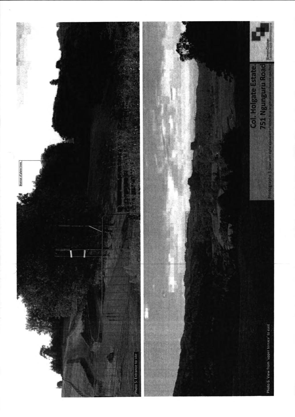
56

57 ~ Existing Land Convenant: Area marked J on DP Proposed Land Convenant: Area marked AH 8 Proposed Land Convenant: Tree Protection BB on 2 Esplanade ~Reserve 3 161Ha 1 i1f ~~ ~[p \\ 1 DP ~e~!ol] 1 s~:> :::?Jo~ "<f Purpose Shown Memorandum of Easements Pedestrian Access A,B &C Servient Tenement 7 L 3 DP DP ~ E2 BB free Protecon 2 Covenant Existing Residence 149Ha 00, c ~~,<: ~ Ha Marked J Consent Notice 2 DP R AF Dominant Tenement s 1, 2,4,5 & 6 &s 1 4 & 5 DP Ha 180 Ha 313 Ha ~ 5 066Ha 1 Marked D Conservation Covenant ) ~, p 1 DP ~ Memorandum of Easements Shown z purpose Servient Dominant!i! Tenement Tenement :;! Right ot way A,B& s 3&5 Right to convey C Electricity & D1, D2, 7 s 3, 5& 6 Telecommunications E,G, Computer Media H,AA& s 3,4, 5,6 2 AJ & 7 Q&R 3 DP Right otway AF 2 DP Proposed Amalgamation Condition S&AJ 2 Amalgamation Conditioin Right of way sec 200 (1)(b)(iv) Right to convey N,P,VT That 7 be held as to six Electricity & AC,AA, 2 4 undivided shares by the owners of s Telecommunications J,H, 1, 2, 3, 4, 5 & 6 as tenant in Computer Media Y&Z common to the said shares and that Right to convey individual CFRs be issued See Electricity & 0, T, 2 1 Telecommunications AC,H& NCm:S Computer Media AA &AJ This plan s Copyright 10 Simpson Shaw Right otway 7 s 2, 3, 4, 5 & surveyors (Stock access) AL 6 This s a conoopl plan Areas and Dimensions Stock Yard Easement K 4 s 1, 2, 3, 5 & are approximate only and subjecllo finalsuney 6 This plan may not be used for Sale and purmase Right otway 4 agreements without first obtaining written consent 7 from Simpson Shaw SuNeyOlS Right ot way AH 1 2 TOTAL AREA =111228Ha REVSONS Date No Deaipllon Sign Schedule of Existing Easements Gross D/08/16 A Proposed stage 2 SUbdivision PS 30 Purpose Shown Servient Tenement Right to convey N, 0, W&AC 2 Electricty M L 6 B 7 X&U 1 Grantee Northpower ~Simpson Shaw ~ Surveyors ~ A DMoon of S1mpoon Shaw & Co lid 154 BANK ST PO BOX 631 PH (09) WHANGARE, 0140 FAX (09) EMAL: surwys@simpsonshawconz WEB: wwwsimpsonshawconz 10 Schedule of Existing N,P,VT Conservation Covenants AC,AA, Shown J,H, Area Description Y&Z Marked A 2257m2 Marked B 2 Marked D 7 Marked F PREPAREO FOR: Col Holgate Estate PROJECT: Proposed Subdivision of 4 DP Ngunguru Road and Proposed easements over s 2 & 3 DP DRAWNNG TTLE: Application Plan 25/11/ G A lof2 o SCALE 1 : 2500(A3)
CA.1 Coastal Area. Index. CA.1.1 Description and Expectations
 Index.1.2.3.4 CA.2 CA.2.1 CA.2.2 CA.2.3 CA.3 CA.3.1 CA.3.2 CA.3.1 CA.4 CA.4.1 CA.4.2 CA.4.3 CA.4.4 CA.5 CA.5.1 CA.5.2 Description and Expectations Objectives Policies Guidance Note Landuse Eligibility
Section 12C Subdivision in the Rural Residential Zone
 Section 12C 12C Subdivision in the Rural Residential Zone The Rural Residential Zone provides part of the range of residential opportunities within the City. Land zoned rural residential is considered
Chapter 3: Natural Environment. Proposed Waikato District Plan Stage 1. (Notified version)
") Chapter 3: Natural Environment Proposed Waikato District Plan Stage 1 Page 2 of 7 Contents Chapter 3: Natural Environment... 3 3.1 Indigenous Vegetation and Habitats... 3 3.1.1 Objective Biodiversity and
Chapter 3: Natural Environment Proposed Waikato District Plan Stage 1 Page 2 of 7 Contents Chapter 3: Natural Environment... 3 3.1 Indigenous Vegetation and Habitats... 3 3.1.1 Objective Biodiversity and
Section 3b: Objectives and Policies Rural Environment Updated 19 November 2010
 Page 1 of Section 3b 3b RURAL ENVIRONMENT 3b.1 Introduction The Rural Environment comprises all the land outside of the Residential, Town Centre and Industrial Environments. Most land within the District
SECTION 2.4 URBAN DEVELOPMENT AND STRATEGIC URBAN DIRECTIONS
 SECTION 2.4 URBAN DEVELOPMENT AND STRATEGIC URBAN DIRECTIONS 2.4.1 INTRODUCTION In 1993/94 the Hastings District Council completed the Hastings Urban Development Strategy. The purpose of this study was:
LANDSCAPE GUIDELINES. Countryside & Coastal Countryside Environments. Landscape, Natural Character & Amenity Values Guide
 Landscape, Natural Character & Amenity Values Guide Copyright WDC 2009 Version A2 18May09 Environmental Services Group Publication Countryside & Coastal Countryside Environments START HERE Quality Land
PART 5 - NATURAL AND PHYSICAL ENVIRONMENT
 CONTENTS...PAGE 5.1 INTRODUCTION...3 5.2 NATURAL RESOURCES...4 5.3 PHYSICAL RESOURCES...4 5.4 COASTAL ENVIRONMENT...4 5.5 HERITAGE FEATURES...4 5.6 HAZARDS...4 5.7 SUMMARY...4 ISTHMUS SECTION - OPERATIVE
I611. Swanson North Precinct
 I611. Swanson North Precinct I611.1. Precinct Description Swanson North is located in the north eastern foothills of the Waitakere Ranges. It is outside the Waitakere Ranges Heritage Area Act and the Waitakere
RLE.1 Rural Living Environment
 Index.1 Description and Expectations.2 Objectives.3 Policies.4 Guidance RLE.2 Landuse RLE.2.1 Eligibility Rules RLE.2.2 Notification Rules RLE.2.3 Discretionary Activities RLE.3 Subdivision RLE.3.1 Eligibility
64 Mineral Extraction Area Rules
 64 Mineral Extraction Area Rules 64.1 Introduction For the purposes of this Chapter: Active Area, in relation to a Mineral Extraction Area (MEA), is that part of the Mineral Extraction Area which is owned
Proposed Southland District Plan 2012 Appeal Version October 2016
 S e c t i o n 3. 5 - F i o r d l a n d / R a k i u r a Z o n e The Fiordland/Rakiura Zone encompasses the Fiordland and Rakiura National Parks and part of Mt Aspiring National Park. It also includes areas
RURAL ZONE - POLICY. Rural Zone Policy. Issue: Rural Environment. Ruapehu District Plan Page 1 of 8
 Rural Zone Policy RU2 RURAL ZONE - POLICY RU2.1 Introduction The natural resources of the rural environment in the Ruapehu District provide the basis for the existing and potential character, intensity
12 Subdivision, Services and Infrastructure
 12 Subdivision, Services and Infrastructure Section 12A 12A Purpose of Subdivision Provisions... 1 12A.1 General Subdivision Objectives and Policies... 2 12A.2 Activity Status Rules... 4 12A.3 General
open space environment
 This section updated August 09 GUIDELINE TO THE RULES The Open Space Environment Rules apply to activities on sites within the Open Space Environment as shown on the Human Environments Maps. Most of the
Bill Stockman PROPOSED SHED PLANNER S REPORT & ASSESSMENT OF ENVIRONMENTAL EFFECTS
 Thomson Survey Limited Shed Land Use Proposal January-19 Bill Stockman PROPOSED SHED 798D Taupo Bay Road PLANNER S REPORT & ASSESSMENT OF ENVIRONMENTAL EFFECTS Thomson Survey Ltd Kerikeri 1.0 INTRODUCTION
H7 Open Space zones. (a) provide for the needs of the wider community as well as the needs of the community in which they are located;
 provide for the needs of the wider community as well as the needs of the community in which they are located;") H7. Open Space zones H7.1. Background The majority of land zoned as open space is vested in the Council or is owned by the Crown. However some areas zoned open space are privately owned. While the open
H7. Open Space zones H7.1. Background The majority of land zoned as open space is vested in the Council or is owned by the Crown. However some areas zoned open space are privately owned. While the open
subdivision GUIDELINES TO THE RULES
 This section updated September 2013 GUIDELINES TO THE RULES This part of the Plan contains rules relating to the of land. Other rules in the Plan also need to be referred to, including the following: The
Rural (Urban Expansion) Environment
 Environment") RUEE.1 Rural (Urban Expansion) Environment Subsequent to the receipt of appeals, a 'marked up' version of the Proposed District Plan was prepared. The provisions of the Proposed Version of the Plan subject
RUEE.1 Rural (Urban Expansion) Environment Subsequent to the receipt of appeals, a 'marked up' version of the Proposed District Plan was prepared. The provisions of the Proposed Version of the Plan subject
Tāhuhu whakaruruhau ā-taone The sheltering ridge pole
 B2. Tāhuhu whakaruruhau ā-taone - Urban growth and form B2.1. Issues Tāhuhu whakaruruhau ā-taone The sheltering ridge pole Auckland s growing population increases demand for housing, employment, business,
I602. Birdwood Precinct
 I602. Birdwood Precinct I602.1. Precinct description The Birdwood Precinct applies to an area west of Don Buck Road and south of Red Hills Road in west Auckland. It incorporates subdivision and development
15 Rural Residential Zone
 15 Rural Residential Zone Section 15A 15A Purpose of the Rural Residential Zone... 1 15A.1 Objectives and Policies of the Rural Residential Zone... 1 15A.2 Activity Status Rules... 5 15A.3 Permitted Activity
SECTION 7A: WHAKARONGO RESIDENTIAL AREA
 SECTION 7A: WHAKARONGO RESIDENTIAL AREA CONTENTS 7A.1 Introduction 1 7A.2 Resource Management Issues 1 7A.3 Objectives and Policies 1 7A.4 Methods 4 7A.5 Residential Zone 4 7A.5.1 Rules: Controlled Activities
1. Assessment of Environmental Effects
 1. Assessment of Environmental Effects Table of Contents 1. Introduction and Overview 1 2. Statutory Assessment 3 3. Site Description 5 4. Proposal Description 7 5. Assessment of Effects on the Environment
I615. Westgate Precinct
 I615. Westgate Precinct I615.1. Precinct Description The Westgate Precinct is located approximately 18km west of the Auckland city centre. There are seven Sub-precincts in the Westgate Precinct: Sub-precinct
GIBBSTON CHARACTER ZONE. QLDC PROPOSED DISTRICT PLAN [PART FOUR] AUGUST gibbston character zone
![GIBBSTON CHARACTER ZONE. QLDC PROPOSED DISTRICT PLAN [PART FOUR] AUGUST gibbston character zone](/thumbs/75/72573993.jpg "GIBBSTON CHARACTER ZONE. QLDC PROPOSED DISTRICT PLAN [PART FOUR] AUGUST gibbston character zone") 23 GIBBSTON CHARACTER ZONE QLDC PROPOSED DISTRICT PLAN [PART FOUR] AUGUST 2015 23 gibbston character zone QLDC PROPOSED DISTRICT PLAN [PART FOUR] AUGUST 2015 23 gibbston character zone 23.1 Zone Purpose
23 GIBBSTON CHARACTER ZONE QLDC PROPOSED DISTRICT PLAN [PART FOUR] AUGUST 2015 23 gibbston character zone QLDC PROPOSED DISTRICT PLAN [PART FOUR] AUGUST 2015 23 gibbston character zone 23.1 Zone Purpose
RPE. Rural Production Environment. Index. RPE.1.1 Description and Expectations
 RPE.1 Rural Production Environment Index RPE.1 Rural Production Environment RCE.1.1 RCE.1.2 RCE.1.3 RCE.1.4 RPE.2 RCE.2.1 RCE.2.2 RCE.2.3 Landuse Description and Expectations Objectives Policies Guidance
Rural (Urban Expansion) Environment
 Environment") RUEE.1 Rural (Urban Expansion) Environment Index RUEE.1 RUEE.1.1 RUEE.1.2 RUEE.1.3 RUEE.1.4 RUEE.2 RUEE.2.1 RUEE.2.2 RUEE.2.3 RUEE.2.4 RUEE.3 Rural (Urban Expansion) Environment Description and Expectations
RUEE.1 Rural (Urban Expansion) Environment Index RUEE.1 RUEE.1.1 RUEE.1.2 RUEE.1.3 RUEE.1.4 RUEE.2 RUEE.2.1 RUEE.2.2 RUEE.2.3 RUEE.2.4 RUEE.3 Rural (Urban Expansion) Environment Description and Expectations
4 Residential and Urban Living Zones
 4 Residential and Urban Living Zones Refer to Chapters 11 to 20 for additional rules that may apply to these zones. 4.1 OBJECTIVES AND POLICIES Objective Res1 Policy 1 Policy 2 Policy 3 Policy 4 Policy
Section 6A 6A Purpose of the Natural Features and Landscapes Provisions
 Section 6A 6A Purpose of the Natural Features and Landscapes Provisions This Chapter addresses the protection and management of natural features and landscapes within the City. The City has a number of
Subdivision and Development
 Subdivision and Development 8.0 Introduction - Subdivision and Development The principle purpose of subdivision is to provide a framework for land ownership so that development and activities can take
Section 12B 12B Subdivision in Residential Zones
 Section 12B 12B Subdivision in Residential Zones The Residential Zones provide for a range of infill and greenfield living opportunities across the City for the community to accommodate current and future
H1. Residential Large Lot Zone
 H1. Residential Large Lot Zone H1.1. Zone description The Residential Large Lot Zone provides for large lot residential development on the periphery of urban areas. Large lot development is managed to
B4. Te tiaki taonga tuku iho - Natural heritage
 B4. Te tiaki taonga tuku iho - Natural heritage Tuia I runga, tuia i raro, tuia ki te waonui a Tiriwa Bind the life forces of heaven and earth to the great realm of Tiriwa B4.1. Issues Auckland s distinctive
Appendix 1 Structure plan guidelines
 Appendix 1 Structure plan guidelines This appendix forms part of the regional policy statement [rps]. 1.1. Introduction Structure plans are an important method for establishing the pattern of land use
Plan Modification to Chapter B2 of the Auckland Unitary Plan(AUP) Operative in part (15 November 2016)
 Operative in part (15 November 2016)") UNITARY PLAN UPDATE REQUEST MEMORANDUM TO FROM Phill Reid Linley Wilkinson DATE 25 September 2018 SUBJECT Plan Modification to Chapter B2 of the Auckland Unitary Plan(AUP) Operative in part (15 November
UNITARY PLAN UPDATE REQUEST MEMORANDUM TO FROM Phill Reid Linley Wilkinson DATE 25 September 2018 SUBJECT Plan Modification to Chapter B2 of the Auckland Unitary Plan(AUP) Operative in part (15 November
Appendix A. Planning Processes. Introduction
 1 Planning Processes Introduction This appendix outlines a number of planning processes which are used in the Auckland Region to support the effective management of development in the region s rural and
E15. Vegetation management and biodiversity
 E15. management and biodiversity E15.1. Background contributes to a range of ecosystem services such as erosion and sediment control, reducing stormwater flows, protecting or enhancing water quality, amenity
11.3 SPECIAL CHARACTER ZONE HAWKE S BAY REGIONAL SPORTS PARK
 11.3 SPECIAL CHARACTER ZONE HAWKE S BAY REGIONAL SPORTS PARK 11.3.1 INTRODUCTION The availability of sports and recreation activities and facilities is important for the maintenance and enhancement of
49 Scheduled Activities
 49 Scheduled Activities 49.1 Rules Explanation The rules for scheduled activities take precedence over the other rules for the Environment in which the scheduled activity is located. This means that, where
2A District-wide Policies
 2A Introduction This Chapter contains policies which are relevant to subdivision, use and development activities occurring across all zones and areas of the District. The policies in this Chapter implement
QLDC PROPOSED DISTRICT PLAN [PART FIVE] AUGUST 2015 SUBDIVISION & DEVELOPMENT
![QLDC PROPOSED DISTRICT PLAN [PART FIVE] AUGUST 2015 SUBDIVISION & DEVELOPMENT](/thumbs/96/128451269.jpg "QLDC PROPOSED DISTRICT PLAN [PART FIVE] AUGUST 2015 SUBDIVISION & DEVELOPMENT") 27 QLDC PROPOSED DISTRICT PLAN [PART FIVE] AUGUST 2015 27 S ub division & D evelopment SUBDIVISION & DEVELOPMENT 27.1 Purpose Subdivision and the resultant development enables the creation of new housing
27 QLDC PROPOSED DISTRICT PLAN [PART FIVE] AUGUST 2015 27 S ub division & D evelopment SUBDIVISION & DEVELOPMENT 27.1 Purpose Subdivision and the resultant development enables the creation of new housing
4 RESIDENTIAL ZONE. 4.1 Background
 4 RESIDENTIAL ZONE 4.1 Background The residential areas within the City are characterised by mainly lowrise dwellings sited on individual allotments. Past architectural styles, settlement patterns and
23B.1 ACTIVITY STATUS RULES COASTAL ZONE
 RULE 23B COASTAL ZONE 23B.1 ACTIVITY STATUS RULES COASTAL ZONE 23B.1.1 PERMITTED ACTIVITIES COASTAL ZONE The following activities are Permitted Activities in the Coastal Zone if they meet all the standards
The Proposed Auckland Unitary Plan (notified 30 September 2013)
") 8 Special Purpose zones 8.1 Airport zone The Airport zone applies to the Kaipara Flats Airfield, North Shore Airfield, Auckland International Airport and Ardmore Airport. Auckland International Airport
8 Special Purpose zones 8.1 Airport zone The Airport zone applies to the Kaipara Flats Airfield, North Shore Airfield, Auckland International Airport and Ardmore Airport. Auckland International Airport
NEW ZEALAND COASTAL POLICY STATEMENT
 NEW ZEALAND COASTAL POLICY STATEMENT 1994 This New Zealand Coastal Policy Statement 1994 was issued by notice in the Gazette on 5 May 1994. PREFACE The Resource Management Act 1991 established a new coastal
I403 Beachlands 1 Precinct
 I403. Beachlands 1 I403.1. Precinct Description Beachlands is a rural and coastal village located on the eastern side of Auckland, adjoining the Tamaki Strait coastline. The original Beachlands village
STRATEGIC DIRECTION. QLDC PROPOSED DISTRICT PLAN [PART TWO] DECISIONS VERSION 3 strategic direction
![STRATEGIC DIRECTION. QLDC PROPOSED DISTRICT PLAN [PART TWO] DECISIONS VERSION 3 strategic direction](/thumbs/79/79711764.jpg "STRATEGIC DIRECTION. QLDC PROPOSED DISTRICT PLAN [PART TWO] DECISIONS VERSION 3 strategic direction") 3 STRATEGIC DIRECTION QLDC PROPOSED DISTRICT PLAN [PART TWO] DECISIONS VERSION 3 strategic direction QLDC DISTRICT PLAN [PART TWO] AUGUST 2015 3 strategic direction 3.1 Purpose This chapter sets out the
3 STRATEGIC DIRECTION QLDC PROPOSED DISTRICT PLAN [PART TWO] DECISIONS VERSION 3 strategic direction QLDC DISTRICT PLAN [PART TWO] AUGUST 2015 3 strategic direction 3.1 Purpose This chapter sets out the
TAURANGA CITY COUNCIL CITY PLAN SECTION 32 REPORT. Chapter 16 Rural Zones
 125 TAURANGA CITY COUNCIL CITY PLAN SECTION 32 REPORT Chapter 16 Rural Zones Table of Contents 1. INTRODUCTION... 3 2. PURPOSE OF THE CHAPTER... 3 3. RECORD OF DEVELOPMENT OF PROVISIONS... 4 3.1 Background
I541. Te Arai North Precinct
 I541. Te Arai North Precinct I541.1. Precinct Description The Te Arai North Precinct contains approximately 616ha of coastal land north of Te Arai Point, generally known as Mangawhai North Forest. The
I542. Te Arai South Precinct
 I542. Te Arai South Precinct I542.1. Precinct Description The Te Arai South Precinct contains approximately 750ha of coastal land south of Te Arai Point, known as Mangawhai South Forest. The land within
Road transport activities and infrastructure can have adverse effects on the environment and community.
 22 Road Transport 22.1 Significant Issues Road transport activities and infrastructure can have adverse effects on the environment and community. Land use activities can have adverse effects on the safety
Planning Proposal Concurrent DA/LEP Amendment for Belmont North Pharmacy Amendment No. 24 to Lake Macquarie Local Environmental Plan (LMLEP) 2014
 2014") Planning Proposal Concurrent DA/LEP Amendment for Belmont North Pharmacy Amendment No. 24 to Lake Macquarie Local Environmental Plan (LMLEP) 2014 Local Government Area: Name of Draft LEP: Subject Land:
Planning Proposal Concurrent DA/LEP Amendment for Belmont North Pharmacy Amendment No. 24 to Lake Macquarie Local Environmental Plan (LMLEP) 2014 Local Government Area: Name of Draft LEP: Subject Land:
I539. Smales 2 Precinct
 I539. Smales 2 Precinct I539.1. Precinct Description The Smales 2 Precinct applies to a 4.8 hectare block of land located on the southern side of Northcote Road and fronting Lake Pupuke, Takapuna. The
Section Three, Part 16 Takanini Structure Plan Area
 PART 16 TAKANINI STRUCTURE PLAN AREA 16.1 Residential 8 zone 16.1.1 Objectives and Policies 16.1.2 Rules: General 16.1.3 Rules: Activity Status Subdivision (Except within the Addison Neighbourhood Centre)
1 INTRODUCTION TO NATURAL ENVIRONMENT
 Kāpiti Coast District Plan Review Section 32 Analysis Summary Report 1 INTRODUCTION TO NATURAL ENVIRONMENT Diverse landscapes, plants and animals make up the natural environment of the District. Much has
THREE PARKS ZONE Three Parks Special Zone The process of applying for resource consents in the zone.
 .25 Three Parks Special Zone The purpose of this zone is to provide for growth and to give effect to the Wanaka 2020 Community (2002) and the more recent Wanaka Structure (2007) and Wanaka Transport Strategy
PART 3 - RESOURCE MANAGEMENT
 CONTENTS... PAGE 3.1 INTRODUCTION... 3 3.2 NATURAL AND PHYSICAL ENVIRONMENT... 3 3.3 URBAN SUSTAINABLE MANAGEMENT... 5 3.4 RESOURCE MANAGEMENT ISSUES... 5 3.5 RESOURCE MANAGEMENT OBJECTIVES AND POLICIES...
Variation 3 Howard Street Residential Development Area
 Variation 3 Howard Street Residential Development Area Amendments to Proposed Hastings District Plan as a Result of Decisions on Submissions 23 rd March 2017 Parts of the Plan affected: Planning Maps Section
QUEENSTOWN LAKES DISTRICT COUNCIL SUBDIVISION DESIGN GUIDELINES
 Attachment C: Draft QLDC Subdivision Design Guidelines QUEENSTOWN LAKES DISTRICT COUNCIL DESIGN GUIDELINES A DESIGN GUIDE FOR AND DEVELOPMENT IN THE URBAN ZONES QUEENSTOWN OFFICE 10 Gorge Road Queenstown
Guidance Notes Completing an AEE
 Guidance Notes Completing an AEE The purpose of this guidance note is to assist you with completing your Assessment of Environmental Effects (AEE) for your land-use consent application. If you do not provide
AOTEA SUPERMARKET ZONE. Zone Introduction
 C18 AOTEA SUPERMARKET ZONE Zone Introduction C18.1 Objective This zone identifies a specific area in Aotea for a stand alone supermarket. The zone is site specific and has a range of objectives, policies
PNE Port Nikau Environment Rules. Index. Page 1 of 37
 PNE.50.1 Port Nikau Environment Index PNE.50.1 PNE.50.1 PNE.50.2 PNE.50.2.1 PNE.50.2.2 PNE.50.3 PNE.50.3.1 PNE.50.3.2 PNE.50.3.3 PNE.50.3.4 PNE.50.4 PNE.50.4.1 PNE.50.4.2 PNE.50.4.3 PNE.50.4.4 PNE.50.5
Planning Proposal Toronto Road, Booragul. Amendment to Lake Macquarie Local Environmental Plan (LMLEP) 2014
 2014") Planning Proposal Toronto Road, Booragul Amendment to Lake Macquarie Local Environmental Plan (LMLEP) 2014 Local Government Area: Name of Draft LEP: Subject Land: Land Owner: Applicant: Folder Number:
Planning Proposal Toronto Road, Booragul Amendment to Lake Macquarie Local Environmental Plan (LMLEP) 2014 Local Government Area: Name of Draft LEP: Subject Land: Land Owner: Applicant: Folder Number:
Landowners Coalition Incorporated. Whangarei District Council
 IN THE ENVIRONMENT COURT ENV-2018-AKL- AT AUCKLAND IN THE MATTER of the Whangarei District Plan and the Resource Management Act 1991 (RMA) AND IN THE MATTER of an appeal under Clause 14(1) of Schedule
I511. Hatfields Precinct
 I511. Hatfields Precinct I511.1. Precinct Description The Hatfields Precinct is a contiguous 183.8 hectare block of rural land held in 8 freehold titles, located immediately to the north of Hatfields Beach.
Huapai North. Variation 127 DECISIONS VERSION. Variation 127 Special 29 Zone
 Huapai North Variation 127 DECISIONS VERSION DECISIONS VERSION The amendments to the Variation that have been made as a result of decisions on submissions are shown as strikethrough or underlined. RESOURCE
Division 13 Local Business and Industry Buffer Zone: Assessment Criteria and Assessment Tables
 Division 13 Local Business and Industry Buffer Zone: Assessment Criteria and Assessment Tables 4.13.1 Local Business and Industry Buffer Zone The provisions in this division relate to the Local Business
REMARKABLES PARK ZONE
 .10 Remarkables Park Zone.10.1 Resources, Activities and Values The Remarkables Park Area comprises approximately 150 hectares of perimeter urban land in the vicinity of Frankton and occupies a strategic
Development Permit Application Form. Property Owner Information as Registered on Legal Title Property Owner Name: Phone:
 Development Application Requirements 1 1926 Tsawwassen Drive Tel: 604-943-2112 Tsawwassen, BC V4M 4G2 www.tsawwassenfirstnation.com Canada Development Permit Application Form Name of Applicant: Address:
AUCKLAND COUNCIL DISTRICT PLAN PAPAKURA SECTION
 AUCKLAND COUNCIL DISTRICT PLAN PAPAKURA SECTION OPERATIVE 16 JUNE 1999 D P Hawkins, Mayor T McLean, Chief Executive Officer Given under the Common Seal of the Papakura District Council this 16th day of
18 Industrial Zones. Section 18A. Appendices
 18 Industrial Zones Section 18A 18A Purpose of the Industrial Zones... 1 18A.1 Purpose of the Industry Zone... 1 18A.2 Purpose of the Port Industry Zone... 1 18A.3 Purpose of the Tauriko Industry Zone...
4.3 Dudley Area Plan. Introduction. History and Existing Character. Desired Future Character for Dudley
 4.3 Dudley Area Plan Introduction The suburb of Dudley has developed as a result of various circumstances including its topography, history and mineral resources. Dudley development has been identified
WELLINGTON CITY DISTRICT PLAN
 Section 32 Report WELLINGTON CITY DISTRICT PLAN PROPOSED DISTRICT PLAN CHANGE 54 REZONING 178 AND 180 OWHIRO BAY PARADE 1 Introduction Before a Proposed District Plan change is publicly notified the Council
54.18 DRURY SOUTH STRUCTURE PLAN AREA
 54.18 DRURY SOUTH STRUCTURE PLAN AREA 54.18.1 CONTEXT The Drury South Structure Plan Area has been identified as a logical location in the southern sector of the Auckland region for addressing part of
SUSTAINABLE MANAGEMENT
 . Sustainable Management.1 The Concept of Sustainable Management The concept of sustainable management recognises there are limits to the use of natural and physical resources and there is a need to balance
CITY VIEW OBJECTIVES
 SECTION 2: CITY VIEW OBJECTIVES CONTENTS 2.1 Introduction 1 2.2 Strategic Direction 1 2.3 The City View Resource Management Issues for the City 1 2.4 The Goal 3 2.5 The City View Objectives 3 Palmerston
RESIDENTIAL. QLDC PROPOSED DISTRICT PLAN [PART THREE] DECISIONS VERSION 8 medium density residential
![RESIDENTIAL. QLDC PROPOSED DISTRICT PLAN [PART THREE] DECISIONS VERSION 8 medium density residential](/thumbs/84/89275880.jpg "RESIDENTIAL. QLDC PROPOSED DISTRICT PLAN [PART THREE] DECISIONS VERSION 8 medium density residential") 8 MEDIUM DENSITY RESIDENTIAL QLDC PROPOSED DISTRICT PLAN [PART THREE] DECISIONS VERSION 8 medium density residential QLDC PROPOSED DISTRICT PLAN [PART THREE] DECISIONS VERSION 8 medium density residential
8 MEDIUM DENSITY RESIDENTIAL QLDC PROPOSED DISTRICT PLAN [PART THREE] DECISIONS VERSION 8 medium density residential QLDC PROPOSED DISTRICT PLAN [PART THREE] DECISIONS VERSION 8 medium density residential
Section Three, Appendix 16C Medium Density Housing, Design Assessment Criteria (Residential 8A zone)
") APPENDIX 16C MEDIUM DENSITY HOUSING, DESIGN ASSESSMENT CRITERIA (RESIDENTIAL 8A ZONE) PURPOSE OF APPENDIX 16C (RESIDENTIAL 8A ZONE) In the Residential 8A Zone the following are defined as restricted discretionary
APPENDIX 16C MEDIUM DENSITY HOUSING, DESIGN ASSESSMENT CRITERIA (RESIDENTIAL 8A ZONE) PURPOSE OF APPENDIX 16C (RESIDENTIAL 8A ZONE) In the Residential 8A Zone the following are defined as restricted discretionary
Proposed Kapiti Coast District Plan
 5 This Chapter primarily implements Objectives 2.1 Tāngata Whenua, 2.3 Development Management, 2.11 Character and Amenity Values, and 2.12 Housing Choice and Affordability as set out in Chapter 2. The
38 Countryside and Coastal Countryside Environment Rules
 38 Countryside and Coastal Countryside Environment Rules 38.1 Introduction This chapter contains rules governing land uses in the Countryside and Coastal Countryside Environments. The boundaries of these
Section 32 report: Natural heritage for the Proposed Natural Resources Plan for the Wellington Region
 Section 32 report: Natural heritage for the Proposed Natural Resources Plan for the Wellington Region Issues and Evaluation Report Section 32 report: Natural heritage for the Proposed Natural Resources
SPECIAL 35 (HIBISCUS COAST GATEWAY) ZONE
 ZONE") `` 12.8.35 SPECIAL 35 (HIBISCUS COAST GATEWAY) ZONE 12.8.35.1 Issues The following provisions relate to the Hibiscus Coast Gateway Zone. This zone is located at Silverdale in the area bounded by State
`` 12.8.35 SPECIAL 35 (HIBISCUS COAST GATEWAY) ZONE 12.8.35.1 Issues The following provisions relate to the Hibiscus Coast Gateway Zone. This zone is located at Silverdale in the area bounded by State
SECTION 32 SUBDIVISION, DEVELOPMENT AND EARTHWORKS
 SECTION 32 SUBDIVISION, DEVELOPMENT AND EARTHWORKS 1 Section 32 Report Publicly Notified on 27 August 2014 CONTENTS 1. STRATEGIC CONTEXT... 3 2. RESOURCE MANAGEMENT ISSUES... 6 3. SCALE AND SIGNIFICANCE
I609. Penihana North Precinct
 I609. Penihana North Precinct I609.1. Precinct description The Penihana North Precinct is located south of the Swanson Railway Station, adjacent to the Rural Urban Boundary (RUB) and Waitakere Ranges Heritage
Northern Territory Compact Urban Growth Policy
 Northern Territory Compact Urban Growth Policy A Reference Policy Document to clause 2.7 (Reference to Policy) of the NT Planning Scheme May 2015 Table of Contents 1 Policy Setting... 3 1.1 Context for
LOTS 3 DP 3146 BLK IV TE MATA SD 1239 Howard Street TW Property Holdings Limited (CT 110/280)
") Schedule 2 - Land Areas to be taken by Designation PLAN Property Address Owner Legal Description Land Area (m 2 ) A LOTS 3 DP 3146 BLK IV TE MATA SD 1239 Howard Street TW Property Holdings Limited (CT
Schedule 2 - Land Areas to be taken by Designation PLAN Property Address Owner Legal Description Land Area (m 2 ) A LOTS 3 DP 3146 BLK IV TE MATA SD 1239 Howard Street TW Property Holdings Limited (CT
Appendix A - Relief sought
 Appendix A - Relief sought Chapter 2 Definitions Definitions Tourism Activity (new) and Visitor Industry (new) The plan does not provide specific definition for tourism. The plan does introduce a new strategic
Part 12 Precinct Area Plans - Wyee West
 TABLE OF CONTENTS 1 INTRODUCTION... 1 1.1 BACKGROUND... 1 1.2 EXTENT OF AREA PLAN... 1 1.3 EXISTING CHARACTER... 2 1.4 ENVIRONMENTAL ATTRIBUTES AND CONSTRAINTS... 2 1.5 DESIRED FUTURE CHARACTER... 3 1.6
NORTH EAST INDUSTRIAL ZONE
 SECTION 12A: NORTH EAST INDUSTRIAL ZONE CONTENTS 12A.1 Introduction 1 12A.2 Resource Management Issues 2 12A.3 Objectives and Policies 3 12A.4 Rules: Permitted Activities 8 R12A.4.1 Permitted Activities
I412. Flat Bush Precinct
 I412. Flat Bush Precinct I412.1. Precinct description The Flat Bush precinct covers approximately 1730ha of land adjacent to the Rural Urban Boundary. The Flat Bush Precinct incorporates the provisions
SCHEDULE THREE TO THE DEVELOPMENT PLAN OVERLAY EASTERN GOLF COURSE KEY REDEVELOPMENT SITE
 DD/MM/YY SCHEDULE THREE TO THE DEVELOPMENT PLAN OVERLAY Shown on the planning scheme map as DPO3 EASTERN GOLF COURSE KEY REDEVELOPMENT SITE 1.0 A permit may be granted before a development plan has been
Draft Ada Street Cardiff Area Plan
 Draft Ada Street Cardiff Area Plan (Draft Amendment to Lake Macquarie Development Control Plan 2014) Exhibition: The draft Area Plan is on public exhibition from 29 February 2016 to 29 March 2016. Submissions:
APPENDIX 9: Archaeological Assessment by Ken Phillips
 APPENDIX 9: Archaeological Assessment by Ken Phillips ARCHAEOLOGICAL ASSESSMENT PROPOSED SERVICE STATION DEVELOPMENT BRUCE ROAD, PAPAMOA TAURANGA Prepared by KEN PHILLIPS (MA HONS) MARCH 2016 ARCHAEOLOGY
6 Landsc apes and rur al char ac
 LANDSCAPES AND RURAL CHARACTER QLDC PROPOSED DISTRICT PLAN [PART TWO] DECISION VERSION ter 6 Landsc apes and rur al char ac 6.1 Purpose Appendix C QLDC DISTRICT PLAN [PART TWO] DECISION VERSION 6 Landsc
Historic Heritage Historic Heritage Explanatory Statement Significant Issues Objectives and Policies...
 Section Contents Historic Heritage... 2 7. Historic Heritage... 2 Explanatory Statement... 2 7.1 Significant Issues... 3 7.2 Objectives and Policies... 3 7.3 Activity Lists... 4 7.4 Matters of Control
I404 Beachlands 2 Precinct
 I404. Beachlands 2 I404.1. Precinct Description The Beachlands 2 precinct covers approximately 6 hectares of land at the corner of Beachlands and Whitford Maraetai Roads. Its purpose is to provide for
H14. Business General Business Zone
 H14. Business General Business Zone H14.1. Zone description The Business General Business Zone provides for business activities from light industrial to limited office, large format retail and trade suppliers.
RESIDENTIAL ENVIRONMENTS
 Chapter 4 RESIDENTIAL ENVIRONMENTS 4.1 SIGNIFICANT RESOURCE MANAGEMENT ISSUES The following resource management issues have been identified as significant throughout Napier s residential environments.
Public Consultation. Land at Monks Farm, North Grove. Welcome
 Welcome Welcome to our public exhibition for development on Land at Monks Farm, orth Grove. Gallagher Estates and Gleeson Strategic Land are preparing an outline planning application for new homes, open
KWE.1 Kamo Walkability Environment
 KWE.1 Kamo Walkability Environment Index KWE.1 Kamo Walkability Environment KWE.1.1 Description and Expectations KWE.1.2 Eligibility Rule KWE.1.3 Objectives KWE.1.4 District Wide Note KAP.1 Kamo Activity