Triangle Land Conservancy Conservation Area Monitoring Report Carolina North
|
|
|
- Adele Kelly Wright
- 5 years ago
- Views:
Transcription
 514 S. Duke St.")
1 Triangle Land Conservancy Conservation Area Monitoring Report Carolina North Property Name: Bolin Creek West Conservation Area Date of visit: April 11, 2018 County: Orange Property Type: Restrictive Covenants Local Contact: Triangle Land Conservancy (office) 514 S. Duke St (fax) Durham, NC Lead conservation area monitor: Caroline Durham Other person(s) attending inspection: Matt Rutledge The Carolina North Property is subject to a Declaration of Restrictive Covenants recorded in Book 5541 page 360 of the Office of the Orange County Register of Deeds. A copy of the Restrictive Covenants may be found at the Register of Deeds office or the link below. Conservation-Areas-.pdf There is a LAND STEWARDSHIP POLICY on file for this property. The Land Stewardship Policy was completed January 15, 2013 and is available at the link below. February pdf Problem areas noted from prior visits and areas to pay special attention to: Minor dumping still occurs along western boundary that is shared with residences, as noted in prior reports. One instance of minor dumping along the southern boundary has been observed in this report (see section B). 1
2 TLC Conservation Area Monitoring Report (Cont.) Are property boundaries clearly marked? Note any new concerns about boundaries and signs of encroachment, and if existing problems have been corrected? Yes. Boundaries clearly marked. No areas of concern. The Restrictive Covenants list eight restricted or prohibited uses and activities. Are there any violations of the following restricted or prohibited uses and activities? A. Construction. Construction or placement of buildings, roads, billboards or other advertising, utilities or other structures on or above the ground is prohibited in the Conservation Areas. Construction or placement of signs is prohibited in the Conservation Areas except for directional and boundary signs, interpretive signs describing the conservation values of the Conservation Areas, and signs and kiosks prescribing rules and regulations for the use of the Conservation Areas. No new construction was observed. B. Dumping and Landfill Activities. Dumping or placing soil or other substances or materials as landfill, or dumping or placing trash, waste or unsightly or offensive materials is prohibited in the Conservation Areas. Minor dumping and landfill activity from adjacent homeowners has been observed along the southern and western boundaries. University personnel may wish to monitor all boundaries more frequently than annually to ensure new homeowners understand the Restrictive Covenants. C. Vegetation Destruction. Removal or destruction of healthy native trees, shrubs or other vegetation is prohibited in the Conservation Areas, unless done as a component of an established forest management plan. No vegetation destruction was observed. D. Excavation or Dredging. Excavation, dredging or removal of loam, peat, gravel, soil, rock or other mineral substance in such manner as to affect the surface is prohibited in the Conservation Areas. No excavation or dredging was observed. E. Detrimental Surface Use. Surface use except for forest or outdoor recreational purposes or purposes permitting the land or water area to remain predominantly in its natural condition is prohibited in the Conservation Areas. No detrimental surface use was observed. 2
3 F. Activities Detrimental to Drainage; Flood Control, etc. Activities detrimental to drainage, flood control, water conservation, erosion control or soil conservation are prohibited in the Conservation Areas. No activities detrimental to drainage, flood control or other listed items were observed. University personnel may wish to monitor the silt fence near the northwestern boundary more frequently than annually, especially after heavy rains. G. Other Detrimental Acts. Other acts or uses detrimental to the retention of land or water areas are prohibited in the Conservation Areas. Based on our observation, the University has been a good steward of the Carolina North property; no detrimental acts were observed during our visits. H. Construction of New Trails and Greenways. Construction of new trails (except for potential greenways and paths that are located and approved pursuant to the terms of the Development Agreement) is prohibited in the Conservation Areas. No new trails or greenways were observed. Additional comments or observations Due to neighboring residences and new development, patches of invasive species (mostly privet) along the southwestern border have been observed. University personnel may wish to monitor such areas more frequently than annually. To the best of your knowledge and observation, is the land owner complying with the restrictive covenants? YES Steward s name: Caroline Durham Signature: L. Caroline Durham Address: 514 S. Duke St. Phone: Durham, NC Indicate attachments to the report. Date and sign all materials. Provide descriptions of photograph and illustration locations. ground photos aerial photos maps illustrations other 3
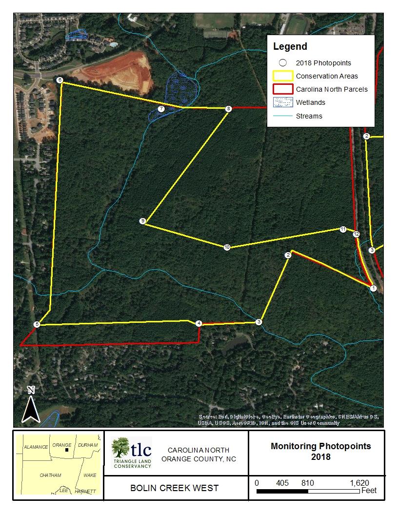
4 Map 4
5 Photo Documentation Table Photo Point Photo Number Description Azimuth 1 a Corner 330 b Corner a Corner 110 b Corner a Corner 270 b Corner 20 4 a Corner 90 b Corner a Corner 90 b Corner 40 6 a Corner 185 b Corner 50 7 a Edge 90 b Edge a Corner 270 b Corner a Corner 25 b Corner a Corner 290 b Corner a Corner 95 b Corner a Corner 265 b Corner 275 5


6 Photopoint 1a: Corner with view north along Photopoint 1b: Corner with view northwest along 4/11/2018 Bolin Creek West 1 Photopoint 2a: Corner with view southeast along Photopoint 2b: Corner with view southwest along


7 Photopoint 3a: Corner with view west along Photopoint 3b: Corner with view northeast along 4/11/2018 Bolin Creek West 2 Photopoint 4a: Corner with view east along Photopoint 4b: Corner with view west along


8 Bolin Creek West 3 Photopoint 5a: Corner with view east along Photopoint 5b: Corner with view north along 4/11/2018 Photopoint 6a: Corner with view south along Photopoint 6b: Corner with view east along


9 Bolin Creek West 4 Photopoint 7a: Edge with view east along Photopoint 7b: Edge with view west along conservation boundary 4/11/2018 Photopoint 8a: Corner with view west along Photopoint 8b: Corner with view southwest along


10 Bolin Creek West 5 Photopoint 9a: Corner with view northeast along Photopoint 9b: Corner with view east along 4/11/2018 Photopoint 10a: Corner with view west along conservation boundary Photopoint 10b: Corner with view east along


11 Bolin Creek West 6 Photopoint 11a: Corner with view east along Photopoint 11b: Corner with view west along 4/11/2018 Photopoint 12a: Corner with view south along Photopoint 12b: Corner with view west along
Triangle Land Conservancy Conservation Area Monitoring Report Carolina North
 Triangle Land Conservancy Conservation Area Monitoring Report Carolina North Property Name: Bolin Creek West Conservation Area Date of visit: 2.18.13, 2.18.13, 3.13.13, and 6.10.13 County: Orange Property
Triangle Land Conservancy Conservation Area Monitoring Report Carolina North
 Triangle Land Conservancy Conservation Area Monitoring Report Carolina North Property Name: Bolin Creek West Conservation Area Date of first visit: 3.12.14 County: Orange Date of second visit: 6.5.14 Property
STATE OF NORTH CAROLINA DECLARATION OF
 Prepared by and Return to: Orange County Parcel Identification Number(s): STATE OF NORTH CAROLINA COUNTY OF ORANGE DECLARATION OF RESTRICTIVE COVENANTS THIS DECLARATION OF RESTRICTIVE COVENANTS ( Declaration
Study Area Map. Wasatch Hollow Open Space Restoration, Use, & Management Plan. Legend. Harrison Ave East. Roosevelt East.
 Harrison Ave Roosevelt Emerson «4 «5 Rosecrest 1900 East «3 1800 East Wasatch Hollow Open Space Restoration, Use, & Management Plan Study Area Map Legend «2 «1 Potential Access Location Emigration Creek
Carolina North Update
 Carolina North Update Public Information Meeting January 30, 2013 1 Agenda 1) Welcome/General Overview 2) Development Agreement: 2012 Annual Report Conservation Areas Restrictive Covenants 3) Signs for
SITE SUMMARY REPORT Arlington Dump NONCD Yadkin County
 SITE SUMMARY REPORT Arlington Dump NONCD 0000644 Yadkin County Hurricane Recovery Act of 2005 State of North Carolina State Contract N06009S Schnabel Project No. 06210002.15 July 31, 2009 Prepared for:
q1 7 q - ~ g -P' ~J~llllllllli tl Jtllllill II I III & '375r;}L. ) . c\1()'1-{6~ol;gl.{ ~ STATE OF NORTH CAROLINA
 . c\1()'1-{6~ol;gl.{ ~ STATE OF NORTH CAROLINA") s ~J~llllllllli tl Jtllllill C3' D6 6 20130207000032200 DECL Bk:RB5541 Pg:360 02/07/2013 02:14:58 PM 1/12 FLED Deborah 8. Brooks -------- Register of Deeds. Orange CO.NC(j Recording Fee: $26.00 ~. NC Real
s ~J~llllllllli tl Jtllllill C3' D6 6 20130207000032200 DECL Bk:RB5541 Pg:360 02/07/2013 02:14:58 PM 1/12 FLED Deborah 8. Brooks -------- Register of Deeds. Orange CO.NC(j Recording Fee: $26.00 ~. NC Real
6Natural. Environment Development Permit Guidelines
 6Natural Bylaw 2600-2016, being "Official Community Plan Bylaw, 2016" Schedule "A" CITY OF ABBOTSFORD OFFICIAL COMMUNITY PLAN Environment Development Permit Guidelines Part V - 6-1 Area Subdivision or
Architectural Review Committee FAQs
 Architectural Review Committee FAQs What kinds of changes to my home require ARC approval? In general all major changes to the exterior of your home require ARC approval. We most commonly receive requests
PLANNED UNIT DEVELOPMENT & SUBDIVISION STAFF REPORT Date: May 18, 2017
 & PUD-0000102-2017 PLANNED UNIT DEVELOPMENT & SUBDIVISION STAFF REPORT Date: May 18, 2017 NAME SUBDIVISION NAME Dauphin Creek Estates Subdivision Dauphin Creek Estates Subdivision LOCATION CITY COUNCIL
Piles, Trenching, Inverters, Cables, Material Deliveries
 Agricultural Inspection Report General Information Project Name Albany Date of Inspection 20161012 Start/End Time 7:50 am Inspector s Name(s) Inspector s Title(s) Describe present phase of construction
Weston s Wetlands, Stormwater, & Open Space
 Weston s Wetlands, Stormwater, & Open Space Weston s Wetlands, Stormwater, & Open Space Conservation Commission Role and Responsibilities Laws that protect wetlands What residents can do to protect wetlands
CHESAPEAKE LANDSCAPE ORDINANCE
 CHESAPEAKE LANDSCAPE ORDINANCE CONSERVATION PRESERVATION CZO 19-600 Effective October 16, 2008 BUFFER YARD C PARKING LOT REFORESTATION YEAR 1 REFORESTATION YEAR 4 BUFFER YARD F CBPA REFORESTATION Page
Banks Pointe Homeowners Association
 Banks Pointe Homeowners Association REGULATIONS January 30, 2012 Rev. April 3, 2013 1 CONTENTS PARKING... 3 STORAGE... 3 MAILBOXES... 3 GARDEN PLOTS... 3 PETS... 4 LAWN ORNAMENTS, DECORATIONS, OUTSIDE
Site Development Plan (SDP) Checklist
 Checklist") Development Services Department 100 N. Wilcox Street, Castle Rock CO 80104 303-660-1393 or CRGov.com Site Development Plan (SDP) Checklist A complete Site Development Plan (SDP) submittal will contain
Development Services Department 100 N. Wilcox Street, Castle Rock CO 80104 303-660-1393 or CRGov.com Site Development Plan (SDP) Checklist A complete Site Development Plan (SDP) submittal will contain
Request for an Exception to the Napa County Road and Street Standards
 F Request for an Exception to the Napa County Road and Street Standards Shed Creek Winery Use Permit P16-327 and Use Permit Exception to the Conservation Regulations P17-178 Planning Commission Hearing
Article 6 Tree Protection
 Article 6 Tree Protection 8.1 Purpose 8.2 Applicability 8.2.1 General Provisions 8.2.2 Exemptions 8.3 Permitting Procedure 8.4 Planting Procedure 8.5 Performance Guarantee Required for Belated Planting
Christopher M. Price, AICP Director of Planning February 7, 2014 STAFF REPORT
 COUNTY OF PRINCE WILLIAM 5 County Complex Court, Prince William, Virginia 22192-9201 PLANNING MAIN (703) 792-7615 FAX (703) 792-4758 OFFICE www.pwcgov.org/planning Christopher M. Price, AICP Director of
COUNTY OF SAN MATEO PLANNING AND BUILDING DEPARTMENT
 COUNTY OF SAN MATEO PLANNING AND BUILDING DEPARTMENT DATE: May 23, 2018 TO: FROM: Planning Commission Planning Staff SUBJECT: EXECUTIVE SUMMARY: Consideration of an appeal of the Community Development
Landscape Edging. objective/goal. Review Process
 objective/goal To enhance the architecture of the buildings, buffer undesirable elements, and complement the natural beauty of the environment, through the effective choice and installation of landscaping,
Kevin M. Rampe, President -- Lower Manhattan Development Corporation
 For Internal Use Only: Date Received: WRP no. DOS no. NEW YORK CITY WATERFRONT REVITALIZATION PROGRAM Consistency Assessment Form Proposed actions that are subject to CEQR, ULURP or other local, state
Buckingham Lake Berkshire Pond Raft s Pond
 Buckingham Lake Berkshire Pond Raft s Pond Some Historical Facts and Other Information about This Waterbody Prepared and Presented By: Daniel R. Hershberg, P.E. & L.S. Managing Partner Hershberg & Hershberg
DRAFT ALDER CREEK FARM MASTER PLAN
 DRAFT ALDER CREEK FARM MASTER PLAN Lower Nehalem Community Trust Mission: To preserve land and nurture conservation values in partnership with an engaged community in the Nehalem region of the Oregon Coast
SITE PLAN (REVISED 8/13/18) l. Development Data Table
 l. Development Data Table") SITE PLAN (REVISED 8/13/18) l. Development Data Table a. Site Acreage: 9.25 b. Tax Parcels included in rezoning: #108-081-07 and #108-081-23 c. Existing Zoning (including overlays and vesting): R-3 (see
SITE PLAN (REVISED 8/13/18) l. Development Data Table a. Site Acreage: 9.25 b. Tax Parcels included in rezoning: #108-081-07 and #108-081-23 c. Existing Zoning (including overlays and vesting): R-3 (see
Finger Lakes National Forest. Backbone Horse Camp Water Hydrant Project
 United States Department of Agriculture Forest Service February 2014 Backbone Horse Camp Water Hydrant Project Scoping Information Hector Ranger District Town of Lodi, Seneca County, New York For Information
SECTION 1 CLEARING /GRADING PERMIT APPLICATION:
 PLEASE REFER TO THE CLEARING & GRADING PERMIT CHECKLIST BELOW FOR SUBMITTAL REQUIREMENTS. SECTION 1 CLEARING /GRADING PERMIT APPLICATION: PROJECT ADDRESS (Street, Suite #): Parcel(s) #: Total Site Area
STAFF REPORT FOR STANDARD COASTAL DEVELOPMENT PERMIT #CDP FEBRUARY 26, 2015 CPA - 1 PO BOX 238 APTOS, CA 94001
 STAFF REPORT FOR STANDARD COASTAL DEVELOPMENT PERMIT #CDP 2014-0030 FEBRUARY 26, 2015 CPA - 1 OWNER/APPLICANT: AGENT: REQUEST: HANS HEIM PO BOX 238 APTOS, CA 94001 JAMES HAY PO BOX 762 MENDOCINO, CA 95460
ME DOT Route 3. File No.: City and State: Bar Harbor, ME
 ME DOT Route 3 File No.: 199600361 City and State: Bar Harbor, ME General Impacts: 0.28 acre tidal emergent 0.77 acre non-tidal forested 0.15 acre non-tidal emergent 0.51 acre non-tidal scrub-shrub Functions
ARTICLE RRCO RED ROCK CORRIDOR OVERLAY DISTRICT
 ARTICLE 11.10 RRCO RED ROCK CORRIDOR OVERLAY DISTRICT (adopted 11/22/2011 MC16-116-11) SECTIONS: 11.10.01 Intent 11.10.02 Boundaries of District 11.10.03 Development Standards 11.10.04 Variance 11.10.01
TO: CITY COUNCIL DATE: MARCH 23,2009
 Report TO: CITY COUNCIL DATE: MARCH 23,2009 FROM: CITY MANAGER SUBJECT: MASTER DEVELOPMENT PLAN AMENDMENT FOR PASADENA CHRISTIAN SCHOOL AT 1515 NORTH LOS ROBLES AVENUE AND GENERAL PLAN AMENDMENT AND ZONE
TOWNSHIP OF LOGAN SOIL & FILL IMPORTATION AND PLACEMENT APPLICATION SUBMITTAL CHECKLIST
 TOWNSHIP OF LOGAN SOIL & FILL IMPORTATION AND PLACEMENT APPLICATION SUBMITTAL CHECKLIST Applications: 5 copies of application - Applicant will reproduce the copies at his/her costs. The Township Clerk
Rule D Wetland and Creek Buffers
 Rule D Wetland and Creek Buffers 1 Policy It is the policy of the Board of Managers to ensure the preservation of the natural resources, recreational, habitat, water treatment and water storage functions
ADDENDUM TO BIOLOGICAL SCOPING SURVEY REPORT, BOTANICAL SURVEY AND WETLAND DELINEATION
 ADDENDUM TO BIOLOGICAL SCOPING SURVEY REPORT, BOTANICAL SURVEY AND WETLAND DELINEATION FOR AVALON INN (APN 069-241-27 & -04) 1201 & 1211 NORTH MAIN STREET FORT BRAGG, CA MENDOCINO COUNTY prepared for:
WELCOME OLD SOUTH The Green Community Input Session. April 6, 2017
 WELCOME OLD SOUTH The Green Community Input Session April 6, 2017 AGENDA Welcome/Introductions Project History Heritage Status Existing Conditions What We ve Heard to Date Design Principles Concept Plan
13. PRELIMINARY PLAT NO MILLS FARM - Vicinity of the southeast corner of 159 th Street and Quivira Road
 13. corner of 159 th Street and Quivira Road 1. APPLICANT: HNTB Corporation is the applicant for this request. 2. REQUESTED ACTION: The applicant is requesting approval of a preliminary plat for a 383-lot
Section 3 Non-Structural BMPs
 3.1 Stream Buffers A stream buffer or stream setback is a designated area around a stream, lake, or wetland left in a natural, densely vegetated state so as to protect the receiving water quality and provide
City of Lafayette Study Session Staff Report Design Review Commission
 ++ City of Lafayette Study Session Staff Report Design Review Commission Meeting Date: January 08, 2018 Staff: Subject: Chris Juram, Planning Technician SS12-17 Miramar Homebuilders, R-20 Zoning: Request
EXHIBIT B PROJECT NARRATIVE POULSBO MEADOWS
 EXHIBIT B PROJECT NARRATIVE POULSBO MEADOWS Name of Project: Poulsbo Meadows; A Planned Residential Development (PRD)/Plat Applicants Name: PBH Group LLC/Byron Harris PO Box 1010 Silverdale, WA 98038 Description
Landscape Rebate: Rainwater Harvesting Rain Garden Installer Guidelines
 City of Santa Monica Office of Sustainability and the Environment 1717 4th Street, Suite 100 Santa Monica, CA 90401 Landscape Rebate: Rainwater Harvesting Rain Garden Installer Guidelines TO QUALIFY FOR
2. Would the proposed project comply with the Land Use map? 3. Would the proposed project require a rezoning? 4. What is the proposed zoning district?
 TOWN OF CHAPEL HILL Planning and Sustainability Department 405 Martin Luther King Jr. Blvd. Chapel Hill, NC 27514 www.townofchapelhill.org phone (919) 968 2728 Concept Plans are intended to be an opportunity
Operations and Maintenance Plan
 Civil Engineering Land Surveying Environmental Consulting Landscape Architecture Operations and Maintenance Plan for Solar Panel Facility Haverhill, MA Prepared By: Hancock Associates #19168 Prepared For:
5. Would the proposed project require modifications to the existing regulations?
 TOWN OF CHAPEL HILL Planning and Sustainability Department 405 Martin Luther King Jr. Blvd. Chapel Hill, NC 27514 www.townofchapelhill.org phone (919) 968-2728 Concept Plans are intended to be an opportunity
STREAM BUFFERS
 88-415 STREAM BUFFERS 88-415-01 PURPOSE In the Kansas City region and throughout the nation, vegetated stream buffers have been clearly shown to protect stream stability and related infrastructure, improve
PLANNED UNIT DEVELOPMENT & SUBDIVISION STAFF REPORT Date: March 15, 2012
 PLANNED UNIT DEVELOPMENT & SUBDIVISION STAFF REPORT Date: March 15, 2012 DEVELOPMENT NAME SUBDIVISION NAME LOCATION OSR Subdivision OSR Subdivision 5559 Old Shell Road (South side of Old Shell Road, 570
2.0 AREA PLANS. Lakeside Business District. Lakeside Business District Land Use Categories:
 Lakeside Business District Lakeside Business District Land Use Categories: Campus Commercial Campus Commercial means a mixture of uses which includes corporate offices, office parks, hotels, commercial,
Fact Sheet Regulating Oceanfront Accessory Structures Updated June 10, 2013
 What is being considered? Fact Sheet Regulating Oceanfront Accessory Structures Updated June 10, 2013 The Town of Duck is considering an ordinance that would limit how close pools, decks, and other accessory
produce food for individual consumption, but may produce food for sale, be designed for
 R-17-283 TOWNSHIP OF MONTCLAIR A RESOLUTION DECLARING THE TOWNSHIP OF MONTCLAIR S SUPPORT FOR THE CREATION, PROTECTION AND LONG-TERM SUSTAINABILITY OF COMMUNITY GARDENS December 19, 2017 WHEREAS, community
GENERAL LANDSCAPE PROVISIONS. The following landscape provisions shall be adhered to by all land uses unless otherwise noted:
 CHAPTER 1.18 Sections: 1.18.005 Purpose. 1.18.010 Landscaping, Buffering, and Fencing Improvements Required. 1.18.015 General Landscape Provisions. 1.18.020 Landscaping Plan. 1.18.025 Single-Family Dwellings
FEDERAL ENERGY REGULATORY COMMISSION FIELD INSPECTION REPORT
 FIELD INSPECTION REPORT Date September 19, 2018 Project Northern Natural Gas Company (Northern) Cedar Station Upgrade Project Dakota County, Minnesota Authority: Section 7(c) Personnel FERC Staff: Company
CITY PLANNING COMMISSION AGENDA ITEM: C STAFF: ROBERT TEGLER FILE NO: CPC PUD QUASI-JUDICIAL
 CPC AGENDA June 8, 2006 Page 37 CITY PLANNING COMMISSION AGENDA ITEM: C STAFF: ROBERT TEGLER FILE NO: CPC PUD 05-294 - QUASI-JUDICIAL PROJECT: APPLICANT: OWNER: PARKWOOD AT WOLF RANCH NASS DESIGN ASSOCIATES
McCormick Pit Category 1 Class A License, Pit Below Water For Blueland Farms Limited. Visual Impact Assessment Report February 2013
 McCormick Pit Category 1 Class A License, Pit Below Water For Blueland Farms Limited Visual Impact Assessment Report February 2013 TABLE OF CONTENTS EXECUTIVE SUMMARY... v 1.0 BACKGROUND... 1 Figure 1.
5. FINAL DEVELOPMENT PLAN APPROVAL MENORAH MEDICAL CENTER OFFICE BUILDING Vicinity of the southwest corner of 119 th Street and Nall Avenue
 5. FINAL DEVELOPMENT PLAN APPROVAL MENORAH MEDICAL CENTER Avenue 1. APPLICANT: Hoefer Wysocki Architects, L.L.C., is the applicant for this request. 2. REQUESTED ACTION: The applicant is requesting final
Kittson Parkway / Watershed Park Parking Lot
 Kittson Parkway / Watershed Park Parking Lot Date Constructed: Summer 2005 Site Location / Description: Kittson Parkway, North Delta, British Columbia. Permeable parking lot adjacent to Watershed Park;
Washtenaw County Conservation District 7203 Jackson Rd Ann Arbor MI Phone: (734) x 5 Fax: (734) Web:
 x 5 Fax: (734) Web:") Washtenaw County Conservation District 7203 Jackson Rd Ann Arbor MI 48103-9506 Phone: (734) 761-6721 x 5 Fax: (734) 662-1686 Web: www.washtenawcd.org STEPS IN BUILDING A POND The following list has been
Washtenaw County Conservation District 7203 Jackson Rd Ann Arbor MI 48103-9506 Phone: (734) 761-6721 x 5 Fax: (734) 662-1686 Web: www.washtenawcd.org STEPS IN BUILDING A POND The following list has been
ARTICLE IX SPECIAL PERMIT USES
 ARTICLE IX SPECIAL PERMIT USES All special permit uses cited in Article IX and Attachment A of this Ordinance or any other Section of this Ordinance shall be subject to Site Plan Review. The procedures
Landfill Closure, Intermediate Cover & Post-Closure Care. Municipal League Meeting
 Landfill Closure, Intermediate Cover & Post-Closure Care Municipal League Meeting 9-7-17 Gated and Closed Landfill Gated means no longer accepting waste. Closed means gated and final cover has been installed
SOIL EROSION AND SEDIMENT CONTROL
 SOIL EROSION AND SEDIMENT CONTROL SECTION 1: AUTHORITY, TITLE AND PURPOSE 11. STATUTORY AUTHORIZATION This ordinance is adopted pursuant to the provisions of the Federal Water Pollution Control Act 86
GENERAL INFORMATIONaaaaaaaaaaaaaaaaaaaaaaaaaaaaaaaa
 To: Planning and Zoning Commission From: City Staff Date: November 15, 2016 Re: Case #16026 Raymore Activity Center Site Plan GENERAL INFORMATIONaaaaaaaaaaaaaaaaaaaaaaaaaaaaaaaa Applicant/ Property Owner:
Rezoning Petition Post-Hearing Staff Analysis July 31, 2018
 Rezoning Petition 2018-044 Post-Hearing Staff Analysis July 31, 2018 REQUEST Current Zoning: R-3 (single family residential) Proposed Zoning: UR-2(CD) (urban residential, conditional) LOCATION Approximately
Plan Policies. Introduction
 Plan Policies Introduction The purpose of the Plan Policies section is to identify the various Governing Body and Planning Commission land use related policy resolutions for use in evaluating development
Jill Stachura STORMWATER BMP AND STREAM RESTORATION IN A CITY PARK. October 2013 Southeast Stormwater Association Annual Conference, Charlotte, NC
 Jill Stachura STORMWATER BMP AND STREAM RESTORATION IN A CITY PARK October 2013 Southeast Stormwater Association Annual Conference, Charlotte, NC Project Location Gwinnett County, GA: Population: 825,000
VALLEY VIEW POND Q&A. This item will be discussed under the First Reading portion of the agenda at the July 17, 2012 Village Council meeting.
 VALLEY VIEW POND Q&A This item will be discussed under the First Reading portion of the agenda at the July 17, 2012 Village Council meeting. 1. Please provide a history of the pond including Village maintenance
Asbury Chapel Subdivision Sketch Plan
 Asbury Chapel Subdivision Sketch Plan PART 1: PROJECT SUMMARY Applicant: NVR Inc. Project Size: +/- 76.13 acres Parcel Numbers: 02101112,02116101,02116112, 02116113 Current Zoning: Transitional Residential
Exhibit A. 8:9 Scuffletown Rural Conservation District
 Exhibit A 8:9 Scuffletown Rural Conservation District 8:9.1 Intent and Purpose The Scuffletown Rural Conservation (SRC) District is intended to provide for residential development that supports the development
Turf Removal Rebate Program Requirements
 Revised July 2018 Turf Removal Rebate Program Requirements 1. You must have grass green, yellow, brown, and/or patches to be eligible for the program and receive project start approval before removing
City of Placerville Planning Commission AGENDA REPORT ITEM 7
 Placerville, a Unique Historical Past Forging into a Golden Future City of Placerville Planning Commission REPORT ITEM 7 MEETING DATE: September 1, 2015 APPLICATION NO: 225 Placerville Drive Site Plan
TERRESTRIAL NATURAL HERITAGE SYSTEM STRATEGY APPENDIX F: MODEL POLICIES FOR THE IMPLEMENTATION OF THE TARGET TERRESTRIAL NATURAL HERITAGE SYSTEM
 TERRESTRIAL NATURAL HERITAGE SYSTEM STRATEGY APPENDIX F: MODEL POLICIES FOR THE IMPLEMENTATION OF THE TARGET TERRESTRIAL NATURAL HERITAGE SYSTEM C H A P T E R 1 M O D E L P O L I C I E S F O R I M P L
Parks for Produce Community Gardens Program 2018
 Parks for Produce Community Gardens Program 2018 Request for Applications As part of the Salt Lake County Urban Farming program, underutilized County park land will be considered for community gardens.
BULLETIN #1 Summerfield/Riverwalk Fencing Criteria
 BULLETIN #1 Summerfield/Riverwalk Fencing Criteria PRIVACY FENCES (typically required on interior lots): Privacy fences shall be a maximum of six (6 ) feet high. The standard fence specified is Country
CITY OF EL CERRITO PUBLIC WORKS DEPARTMENT
 CITY OF EL CERRITO PUBLIC WORKS DEPARTMENT LANDSCAPE MAINTENANCE RFP Q & A To: All Proposers May 7, 2015 The following are answers to questions received as of the deadline for final questions on May 5,
SUBMITTAL REQUIREMENTS: FINAL PLAN REVIEW- PROJECT DEVELOPMENT PLAN (PDP)
") 1) Application form and filing fee. Application Form.pdf Development Review Guide STEP 6 of 8 SUBMITTAL REQUIREMENTS: FINAL PLAN REVIEW- PROJECT DEVELOPMENT PLAN (PDP) 2) Transportation Development Review
1) Application form and filing fee. Application Form.pdf Development Review Guide STEP 6 of 8 SUBMITTAL REQUIREMENTS: FINAL PLAN REVIEW- PROJECT DEVELOPMENT PLAN (PDP) 2) Transportation Development Review
A Useful Process for the Design of Outdoor Spaces
 Native Plant Gardening Certificate Series Class Title: Native Plant Gardening Landscape Design Instructor: Patricia Michael A Useful Process for the Design of Outdoor Spaces By Patricia Michael Copyright
Request Modification of Conditions of a Conditional Use Permit approved October 14, Staff Recommendation Approval. Staff Planner Stephen White
 Applicant Property Owner Public Hearing September 13, 2017 City Council Election District Lynnhaven Agenda Item 3 Request Modification of Conditions of a Conditional Use Permit approved October 14, 2003.
Zoning Ordinance Article 3
 Article 3 Natural Resources Protection Section 301 Natural Resources Protection 301.1. Purpose - The following natural resources protection standards are established to protect the public health, safety
PG&E WINTERS GAS OPERATIONS AND TECHNICAL TRAINING CENTER
 PG&E WINTERS GAS OPERATIONS AND TECHNICAL TRAINING CENTER CEQA scoping Meeting March 19 th, 2014 Winters City Council Chambers - 6:30 pm AGENDA FOR THE MEETING 6:30 Welcome (John Donlevy) 6:40 Overview
SUBMITTAL REQUIREMENTS
 WHEN PROCESS TYPE III IS USED References to Process Type III applications are found in several places in the Milton Municipal Code (MMC), indicating that the development, activity, or use, is permitted
 NOTES: 1.) THE BOGGY CREEK RD. AND SIMPSON RD. IMPROVEMENTS DEPICTED ON THIS PLAN ARE BASED ON RECORD CONSTRUCTION PLANS AND HAVE NOT BEEN SURVEYED. 2.) EXISTING RESIDENTIAL BUILDING STRUCTURES AND ANCILLARY
HICKORY NUT FOREST DESIGN GUIDELINES
 HICKORY NUT FOREST DESIGN GUIDELINES Introduction Hickory Nut Forest is a "net-zero energy", conservation development that is designed to protect and celebrate the property s unique ecology. A conservation
Design Review Application *Please call prior to submittal meeting to determine applicable fees*
 CITY OF EAGLE 660 E. Civic Lane, Eagle, ID 83616 Phone#: (208) 939-0227 Fax: (208) 938-3854 Design Review Application *Please call prior to submittal meeting to determine applicable fees* FILE NO.: CROSS
Stream Restoration: Working with Nature?
 Stream Restoration: Working with Nature? Greg Jennings, PhD, PE jenningsenv@gmail.com Ecosystem Restoration activities that initiate or accelerate the recovery of ecosystem health, integrity, and sustainability
Stream Restoration: Working with Nature? Greg Jennings, PhD, PE
 Stream Restoration: Working with Nature? Greg Jennings, PhD, PE jenningsenv@gmail.com Ecosystem Restoration activities that initiate or accelerate the recovery of ecosystem health, integrity, and sustainability
Pequotsepos Brook Preserve
 AVALONIA LAND CONSERVANCY, Inc. P.O. Box 49, Old Mystic, CT 06372 Pequotsepos Brook Preserve Property Management Plan Maritime Drive Mystic, New London County, Connecticut Stonington Town Committee is
Zoning Ordinance Chapter 10
 CHAPTER 10 - WASHES SECTION 10.0 GENERAL: A. The purpose of this Ordinance is to establish standards for development in or near Major and Minor Washes as defined in Appendix A Glossary of Terms and Definitions
2. Analysis. DRAFT Gerald Richards & Pleasantview Park Master Plan
 DRAFT Gerald Richards & Pleasantview Park Master Plan 19 Historic Features According to the National Register of Historic Places and the National Historic Landmarks Program, there is nothing of national
Mill Conversion Overlay District Zoning Bylaw Amendment
 Mill Conversion Overlay District Zoning Bylaw Amendment To see if the Town will vote to amend the Zoning By-Law by adding a new Section 13, Mill Conversion Overlay District, and by amending Sections 2.1,
Project phasing plan (if applicable) 12 copies of site plan
 12 copies of site plan") SITE PLAN REVIEW PERMIT APPLICATION City of Grand Haven, 11 N. Sixth Street, Grand Haven, MI 49417 Phone: (616) 847-3490 Fax: (616) 844-2051 Website: www.grandhaven.org 1. Project Information Address/location
SITE PLAN REVIEW PERMIT APPLICATION City of Grand Haven, 11 N. Sixth Street, Grand Haven, MI 49417 Phone: (616) 847-3490 Fax: (616) 844-2051 Website: www.grandhaven.org 1. Project Information Address/location
FARMING PROTECTION. The Farming Protection Development Permit Guidelines are organized into five main categories:
 Development Permits Farming Protection DP4 DEVELOPMENT PERMIT GUIDELINES: FARMING PROTECTION The Farming Protection Development Permit Guidelines are organized into five main categories: General Single
PLANNED UNIT DEVELOPMENT APPLICATION
 PLANNED UNIT DEVELOPMENT APPLICATION CITY OF THE DALLES Community Development Department 313 Court Street The Dalles, OR 97058 (541) 296-5481, ext. 1125 Fax (541) 298-5490 www.ci.the-dalles.or.us Date
2018 Annual Landfill Inspection Report
 2018 Annual Landfill Inspection Report Landfill H.W. Pirkey Plant Southwestern Electric Power Company Hallsville, Texas December 17, 2018 Prepared for: Southwestern Electric Power Company H.W. Pirkey Plant
STREAM BANK STABILIZATION THORPS MORTIMER RECREATION AREA Grandfather Ranger District SITE LOCATION & DRAINAGE AREA
 STREAM BANK STABILIZATION THORPS CREEK @ MORTIMER RECREATION AREA SITE LOCATION & DRAINAGE AREA SITE LOCATION Drainage Area = 1.14 sq. miles STREAM BANK STABILIZATION THORPS CREEK @ MORTIMER RECREATION
# 17 & 18 ZON & ZON PLANNED UNIT DEVELOPMENT & PLANNING APPROVAL STAFF REPORT Date: February 5, Mobile Carnival Association
 PLANNED UNIT DEVELOPMENT & PLANNING APPROVAL STAFF REPORT Date: February 5, 2009 NAME LOCATION Mobile Carnival Association South side of Bloodgood Street at its West terminus CITY COUNCIL DISTRICT District
TO BE COMPLETED BY APPLICANT
 Planning Division #200-2564 Shaughnessy Street Port Coquitlam BC V3C 3G4 Tel 604.927.5442 Fax 604.927.5404 Email planning@portcoquitlam.ca Application for Watercourse Development Permit Watercourse Development
COUNTY OF SACRAMENTO CALIFORNIA PLANNING COMMISSION REPORT
 COUNTY OF SACRAMENTO CALIFORNIA PLANNING COMMISSION REPORT TO: FROM: SUBJECT: COUNTY PLANNING COMMISSION DEPARTMENT OF COMMUNITY DEVELOPMENT GROWTH AREA PLANS UPDATE CONTACT: Cindy Storelli, Principal
CLACKAMAS COUNTY ZONING AND DEVELOPMENT ORDINANCE
 704 RIVER AND STREAM CONSERVATION AREA (RSCA) 704.01 PURPOSE Section 704 is adopted to: A. Maintain the integrity of the rivers and streams in the County by minimizing erosion, promoting bank stability,
Minnesota Department of Natural Resource - Natural Resource Guidance Checklist Conserving Natural Resources through Density Bonuses
 Minnesota Department of Natural Resource - Natural Resource Guidance Checklist Conserving Natural Resources through Density Bonuses NRDB Why Use Density Bonuses & This Checklist Local units of government
Stormwater Standards. Clackamas County Service District No. 1. Planting Guide for Buffers
 Stormwater Standards Clackamas County Service District No. 1 APPENDIX B Planting Guide for Buffers Table of Contents Appendix B - Planting Guide for Buffers... Page B.1 General... 1 B.1.1 Introduction...
FUTURES: Regional Growth Modeling for NC Building a FUTURES Forecasting Model for the Triangle and Rocky Mount Regions
 FUTURES: Regional Growth Modeling for NC Building a FUTURES Forecasting Model for the Triangle and Rocky Mount Regions Presented by: Jeff Michael, RENCI at UNC Charlotte John Vogler, UNCC Center for Applied
SECTION 11.07: WETLAND BUFFER ORDINANCE
 11.07. Wetland Buffer Ordinance 1.0 Council Findings, Purpose, and Means. SECTION 11.07: WETLAND BUFFER ORDINANCE Section 11.07: Wetland Buffer Ordinance Subdivision 1.0: Council Findings, Purpose, and
Biological Constraints Survey for 5th Street Drainage Improvements. City of Highland, San Bernardino County, California
 for 5th Street Drainage Improvements City of Highland, San Bernardino County, California August 2010 Prepared for City of Highland 27215 Baseline Highland, CA 92346 Prepared by HDR Engineering, Inc. 8690
HAMPTON CEMETERY RULES, REGULATIONS & RATES
 HAMPTON CEMETERY RULES, REGULATIONS & RATES The Hampton Cemetery is owned and operated by the City of Hampton, Iowa. The management of the Hampton Cemetery shall be vested in the City Manager. The Hampton