City of Lafayette Staff Report
|
|
|
- Rodney Anderson
- 5 years ago
- Views:
Transcription
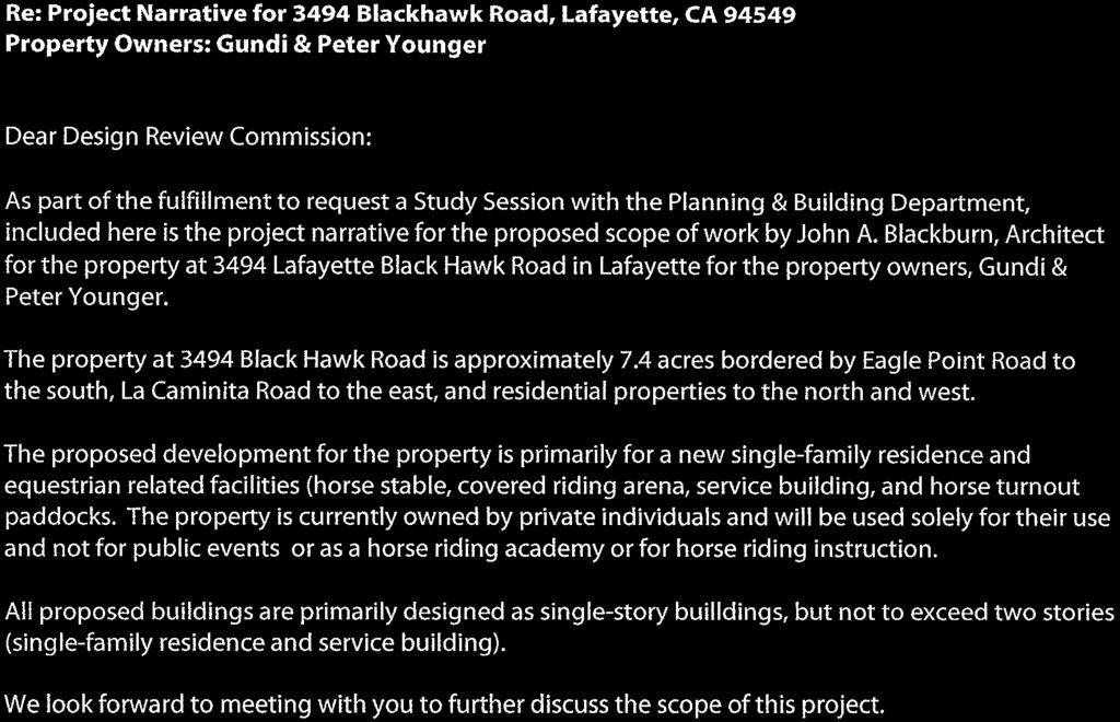
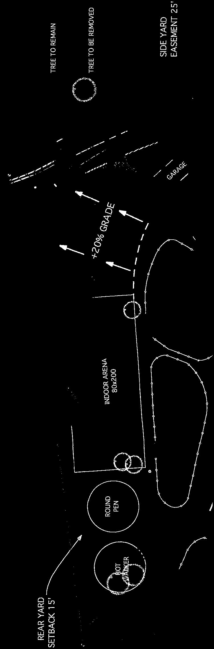
1 City of Lafayette Staff Report For: By: Design Review Commission Greg Wolff, Senior Planner Meeting Date: April 27, 2015 Subject: SS03-15 Gundi & Peter Younger (Owners), R-40 Zoning: Request for a Study Session with the Design Review Commission to discuss constructing a new singlefamily residence and equestrian related facilities (horse stable, covered riding arena, service building, and horse turnout paddocks) for private use (not public riding or instruction) on a 7.4-acre property in the Hillside Overlay District at 3494 Black Hawk Road. APN OVERVIEW A study session is not a formal application for development that results in a commission taking action to approve or deny a specific project. It is an opportunity to informally discuss aspects of a contemplated project with the Design Review Commission and receive feedback on what is presented. Accordingly, Planning staff does not evaluate the submitted plans for conformance with development standards and the findings that would be required to approve the project. The required findings that the Commission will need to make in order to approve the project are included later in this report. Site Address: 3494 Blackhawk Road APN: Zoning: Single-Family Residential District 40 (R-40) Lot Area: 7.4 acres Existing Use: General Plan Designation: Existing single-family residence Low-Density Single-Family Residential; (up to 2 dwelling units/acre) Proposed Use: Flood Zone: Single-Family Residence with equestrian facilities X Trigger Yes No Trigger Yes No Within a protected ridgeline setback? Grading > 50 cu.yds? Within 100-ft. of a ridgeline setback? DR required as condition of approval? In the Hillside Overlay District? In a commercial or MFR zone? Over 17-ft. in height to ridge? Variance requested? Development > 6,000 sq. ft.? Tree Permit Requested? Creek Setback required? Subject to Public Art Ordinance? 1
2 Design Review Commission SS03-15 Younger Staff Report April 27, 2015 PROJECT DATA FROM THE PLANS DATED APRIL 27,
3 Design Review Commission SS03-15 Younger Staff Report April 27, 2015 FINDINGS If a formal application is submitted, the hearing body will need to make the following findings in order to approve the project: 6-275(A) Residential Design Review Findings In granting approval for projects which occur in single-family and multiple-family residential zoning districts as outlined in Section 6-271(A)(1 and 3-6), the hearing authority shall make all the following findings: 1. The approval of the plan is in the best interest of the public health, safety and general welfare; 2. General site considerations, including site layout, open space and topography, orientation and location of buildings, vehicular access, circulation and parking, setbacks, height, walls, fences, public safety and similar elements have been designed to provide a desirable environment for the development; 3. General architectural considerations, including the character, scale and quality of the design, the architectural relationship with the site and other buildings, building materials, colors, screening of exterior appurtenances, exterior lighting and signing and similar elements have been incorporated in order to ensure the compatibility of this development with its design concept and the character of adjacent buildings; and 4. General landscape considerations, including the location, type, size, color, texture and coverage of plant materials, provisions for irrigation, maintenance and protection of landscaped areas and similar elements have been considered to ensure visual relief, to complement buildings and structures and to provide an attractive environment for the enjoyment of the public (C) Single-Family Residential Findings Exceeding 17-Feet in Height In addition to the findings required in Section 6-275(A), the hearing authority shall make the following findings for projects which occur in single-family residential zoning districts and exceeds 17 feet in height as outlined in Section 6-272(A)(4): 1. The structure substantially complies with the Residential Design Guidelines; 2. The structure is so designed that it will appear compatible with the scale and style of the existing neighborhood and will not significantly detract from the established character of the neighborhood; 3. The structure is so designed that it does not appear too tall or massive in relation to surrounding structures or topography when viewed from off-site; and 4. The structure is so designed that it does not unreasonably reduce the privacy or views of adjacent properties (B) Single-Family Residential Findings Exceeding 6,000 Square Feet In addition to the findings required in Section 6-275(A), the hearing authority shall make the following findings for projects which occur in single-family residential zoning districts and exceeds 6,000 square feet in gross floor area as outlined in Section 6-272(A)(3): 3
4 Design Review Commission SS03-15 Younger Staff Report April 27, The house substantially complies with the Residential Design Guidelines; 2. The house is so designed that its mass will not appear significantly out of scale with the existing neighborhood; 3. The house does not, because of its size, unduly impact, restrict or block significant views; and 4. The house does not, because of its size, require removal of natural features, require excessive grading or cause the unnecessary removal of a healthy tree(s) Findings required for approval of a hillside development permit on an existing lot of record. (a) The development is consistent with the applicable goals and policies of the general plan and is in conformance with applicable zoning regulations; (b) The development will preserve open space and physical features, including rock outcroppings and other prominent geological features, streams, streambeds, ponds, drainage swales, native vegetation, native riparian vegetation, animal habitats and other natural features; (c) Structures in the hillside overlay district will, to the extent feasible, be located away from prominent locations such as ridgelines, hilltops, knolls and open slopes; (d) The development, including site design and the location and massing of all structures and improvements will, to the extent feasible: (1) Minimize the loss of privacy to surrounding residents and not unduly impact, restrict or block significant views; (2) Not have a significant visual impact when viewed from lower elevations from public places, using the viewing evaluation map as a guide to establish locations from which views are considered; and (3) Not interfere with a ridgeline trail corridor or compromise the open space or scenic character of the corridor. (e) Within 100 feet of a restricted ridgeline area, or when an exception to a ridgeline setback has been granted, the development will result in each structure being substantially concealed by terrain or vegetation when viewed from lower elevations from public places, using the viewing evaluation map as a guide to establish locations from which views are considered; (f) Development grading will be minimized to limit scarring and cutting of hillsides especially for long roads or driveways, preserve existing geologic features, topographic conditions and existing vegetation, reduce short and long-term erosion, slides and flooding, and abate visual impacts; (g) The development provides adequate emergency vehicle access, including turn-around space, to the building site and surrounding on-site undeveloped or isolated areas; (h) Each structure and proposed landscaping complies with the city s residential design guidelines; (i) The new or replacement vegetation for the development is native to the surrounding area in areas abutting open space and natural areas, such as oak woodland, chaparral, grassland and riparian areas, and conforms to the policies of Section ; and (j) The development will not create a nuisance, hazard or enforcement problem within the neighborhood or the city, nor require the city to provide an unusual or disproportionate level of public services. 4
5 Design Review Commission SS03-15 Younger Staff Report April 27, Findings required for approval of grading exceeding 50 cubic yards 1. The grading will not endanger the stability of the site or adjacent property or pose a significant ground movement hazard to an adjacent property. The decision making authority may require the project geotechnical engineer to certify the suitability of the project supported by appropriate technical studies, including subsurface investigation; 2. The grading will not significantly increase erosion or flooding affecting the site or other property and will not cause impacts to riparian habitats, stream channel capacity or water quality that cannot be substantially mitigated; 3. The grading, when completed, will result in a building site that is visually compatible with the surrounding land; 4. The grading is sensitive to the existing landforms, topography and natural features on the site; 5. The design of the project preserves existing trees on the site and trees on adjoining property to the extent possible. RECOMMENDATION Provide feedback to the applicant. This is an informational item and no formal action will be taken. ATTACHMENTS 1. Aerial Photos & Maps 2. Project Plans dated April 27,

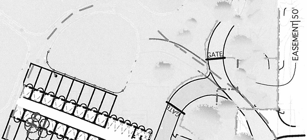
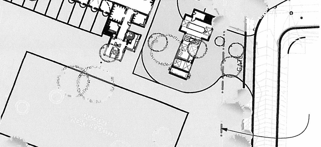
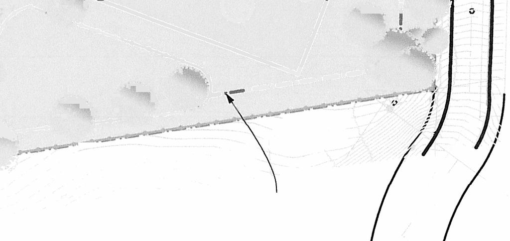
6 3494 Blackhawk Road APN inch = 1000 feet Location Map 2012 Digital Map Products. All rights reserved. 1

7 3494 Blackhawk Road APN inch = 250 feet 2012 Digital Map Products. All rights reserved. 1

8 3494 Blackhawk Road APN inch = 150 feet 10' Contours 2012 Digital Map Products. All rights reserved. 1

9 3494 Blackhawk Road APN inch = 250 feet Property is in the Hillside Overlay District 2012 Digital Map Products. All rights reserved. 1


10


11
City of Lafayette Study Session Staff Report Design Review Commission
 ++ City of Lafayette Study Session Staff Report Design Review Commission Meeting Date: January 08, 2018 Staff: Subject: Chris Juram, Planning Technician SS12-17 Miramar Homebuilders, R-20 Zoning: Request
City of Lafayette Study Session Staff Report Design Review Commission
 City of Lafayette Study Session Staff Report Design Review Commission Meeting Date: April 24, 2017 Staff: Payal Bhagat, Senior Planner Subject: HDP18-15 & HDP31-15 Ramesh Patel & Melcor Development (Owners),
City of Lafayette Staff Report
 City of Lafayette Staff Report For: By: Planning Commission Megan Canales, Planning Technician Meeting Date: January 20, 2015 Subject: Deadline: HDP15-14 RSR Development Company (Owners) R-10 Zoning: Request
City of Lafayette Study Session Project Data
 City of Lafayette Study Session Project Data For: Design Review Commission By: Michael P. Cass, Senior Planner Date: August 24, 2015 Property Address: 954 Mountain View Drive APN: 243-070-011 Zoning District:
City of Lafayette Staff Report
 City of Lafayette Staff Report For: By: Design Review Commission Greg Wolff, Senior Planner Meeting Date: November 25, 2013 Subject: L03-11 O BRIEN LAND CO., LLC (APPLICANT), AMD FAMILY TRUST (OWNER),
COMPLIANCE CHECKLIST HILLSIDE RESIDENTIAL DESIGN GUIDELINES MANUAL
 COMPLIANCE CHECKLIST HILLSIDE RESIDENTIAL DESIGN GUIDELINES MANUAL The following checklist summarizes development guidelines and standards. See the appropriate section for a complete explanation of the
File No (Continued)
") (Continued) Request for: (1) a Site Plan Review; (2) a Variance (to build on a significant ridgeline); (3) an Oak Tree Permit (to encroach into the protected zone of 25 oak trees and for potential thinning
(Continued) Request for: (1) a Site Plan Review; (2) a Variance (to build on a significant ridgeline); (3) an Oak Tree Permit (to encroach into the protected zone of 25 oak trees and for potential thinning
City of Lafayette Staff Report
 City of Lafayette Staff Report For: By: Design Review Commission Sarah Allen, Associate Planner Meeting Date: May 23, 2016 Subject: Deadline: HDP04-16 Joe Egan (Owner) R-20 Zoning: Request for (1) a Hillside
Site Design (Table 2) Fact Sheet & Focus Questions:
 Fact Sheet & Focus Questions:") Site Design (Table 2) Fact Sheet & Focus Questions: BACKGROUND WHAT IS SITE DESIGN? Site design refers to the arrangement of buildings and open spaces on adjacent sites to maximize the shared benefits
Site Design (Table 2) Fact Sheet & Focus Questions: BACKGROUND WHAT IS SITE DESIGN? Site design refers to the arrangement of buildings and open spaces on adjacent sites to maximize the shared benefits
Zoning Ordinance Chapter 10
 CHAPTER 10 - WASHES SECTION 10.0 GENERAL: A. The purpose of this Ordinance is to establish standards for development in or near Major and Minor Washes as defined in Appendix A Glossary of Terms and Definitions
City of Lafayette Staff Report
 City of Lafayette Staff Report For: By: Planning Commission Megan Canales, Planning Technician Meeting Date: April 6, 2015 Subject: Deadline: HDP15-14 RSR Development Company (Owners) R-10 Zoning: Request
A. General Plan: Land Use, Growth Management and the Built Environment Element. d. Use visually unobtrusive building materials.
 Chapter 16 Hillside Protection 16.010 Purpose This chapter establishes the regulations for development and alteration of properties in hillside and ridgeline areas in order to preserve the essential scenic
ARTICLE IV: DEVELOPMENT STANDARDS 404 MASTER PLANNING
 IV 13 404 MASTER PLANNING Master Planning through the Site Analysis (Master Planning Site Analysis) or Planned Development (Master Planning Planned Development) is provided to encourage development which
GENERAL PLAN CONSISTENCY ANALYSIS
 GENERAL PLAN CONSISTENCY ANALYSIS Prepared by Planning Staff 10/28/2013 APPLICABLE GOALS, POLICIES AND PROGRAMS FROM the LAND USE CHAPTER Goal LU-1 Policy LU-1.1 Policy LU-1.2 Goal LU-2 Protect the character
RESIDENTIAL GUIDELINES CHECKLIST
 RESIDENTIAL GUIDELINES CHECKLIST The following checklist was created to provide you with an easy way to ensure that your project complies with the Residential Design Guidelines. RESIDENTIAL DESIGN GUIDELINES
CITY OF LAGUNA BEACH COMMUNITY DEVELOPMENT DEPARTMENT STAFF REPORT DESIGN REVIEW BOARD IBOARD OF ADJUSTMENT Coast Highway APN
 CITY OF LAGUNA BEACH COMMUNITY DEVELOPMENT DEPARTMENT STAFF REPORT HEARING DATE: October 13,2011 TO: DESIGN REVIEW BOARD IBOARD OF ADJUSTMENT CASE: Variance 7717 Design Review 11-163 Coastal Development
ORDINANCE NO WHEREAS, the City of Kalama has many areas of timberland and open areas inside its City limits adjacent to residential areas;
 ORDINANCE NO. 1342 AN ORDINANCE OF THE CITY OF KALAMA, WASHINGTON ADOPTING A NEW KALAMA MUNICIPAL CODE CHAPTER 17.20 ESTATE LOT FLOATING ZONE TO PROVIDE TRANSITIONAL ZONING OPTIONS FOR RESIDENTIAL DEVELOPMENT
PLANNING COMMISSION AGENDA REPORT APRIL 7, 2016
 PLANNING COMMISSION AGENDA REPORT APRIL 7, 2016 TO: FROM: Members of the Planning Commission Talyn Mirzakhanian, Senior Planner FILE NO.: 160001710 PROPOSAL: APPLICANT: RECOMMENDATION: A request for a
14825 Fruitvale Ave.
 REPORT TO THE PLANNING COMMISSION Meeting Date: August 26, 2015 Application: PDR14-0017 Location/APN: 14825 Fruitvale Ave. / 397-18-028 Applicant/Owner: Staff Planner: Sin Yong Michael Fossati 14825 Fruitvale
F. The following uses in the HR District: attached single-family dwellings, condominiums, and institutional uses; and
 1102 DESIGN REVIEW 1102.01 PURPOSE AND APPLICABILITY Section 1102 is adopted to provide standards, criteria, and procedures under which design review may be approved. Design review is required for: A.
CHAPTER 22 Rural Open Space Community Developments
 CHAPTER 22 Rural Open Space Community Developments Section 22.1 Description and Purpose The intent of this Chapter is to offer property owners an alternative to traditional zoning requirements for rural
THE CITY COUNCIL OF THE CITY OF SAN JUAN BAUTISTA DOES HEREBY ORDAIN AS FOLLOWS:
 ORDINANCE NO. 2016 01 AN ORDINANCE OF THE CITY OF SAN JUAN BAUTISTA AMENDING THE SAN JUAN BAUTISTA MUNICIPAL CODE TO ADD CHAPTER 11-08 HILLSIDE DEVELOPMENT REGULATIONS WHEREAS, the City Council has reviewed
Land Use and Planning
 9 Land Use and Planning This chapter describes existing land uses, the General Plan land use classification and zoning designation of the Project sites, and applicable General Plan policies. The chapter
SENSITIVE LANDS OVERLAY
 SENSITIVE LANDS OVERLAY Chapter 22 Sensitive Lands Overlay 22.1 PURPOSE 22.2 APPLICATION AND ANALYSIS REQUIREMENTS 22.3 SENSITIVE LAND REGULATIONS 22.4 ADMINISTRATIVE PROVISIONS 22.5 DESIGN STANDARDS 22.6
PC RESOLUTION NO
 PC RESOLUTION NO. 14-01-14-02 TENTATIVE TRACT MAP fttm) 17441. REZONE {RZ) 13-003, ARCHITECTURAL CONTROL (AC) 13-003, TREE REMOVAL PERMIT (TRP) 13-052. GRADING PLAN MODIFICATION (GPM) 13-002. CONDITIONAL
-MENDOCINO COUNTY PLANNING AND BUILDING SERVICES- DIVISION II OF TITLE 20--COASTAL ZONING CODE
 CHAPTER 20.504 VISUAL RESOURCE AND SPECIAL TREATMENT AREAS Sec. 20.504.005 Applicability. Sec. 20.504.010 Purpose. Sec. 20.504.015 Highly Scenic Areas. Sec. 20.504.020 Special Communities and Neighborhoods.
Planned Development Review Revisions (Project No. PLNPCM )
") Planned Development Review Revisions (Project No. PLNPCM2014-00139) Standard residential development Planned Development Example: Smaller lot sizes than what is allowed to create open space amenity. What
Planned Development Review Revisions (Project No. PLNPCM2014-00139) Standard residential development Planned Development Example: Smaller lot sizes than what is allowed to create open space amenity. What
PLANNING COMMISSION AGENDA REPORT SEPTEMBER 1, 2016
 PLANNING COMMISSION AGENDA REPORT SEPTEMBER 1, 2016 TO: Members of the Planning Commission FROM: Michael Klein, Planner FILE NO.: 150000780 PROPOSAL: APPLICANT: RECOMMENDATION: A request for a Site Plan
Example Codes. City of Brentwood, Tennessee Brentwood Hillside Protection Overlay District Summary
 Example Codes City of Brentwood, Tennessee Brentwood Hillside Protection Overlay District Summary The City of Brentwood in July 2007 adopted a Hillside Protection (HP) Overlay District to address the problems
APPENDIX A 6 CONCEPTUAL PRELIMINARY PLAN GUIDE AND CHECKLIST FOR MAJOR SUBDIVISIONS CARRBORO DEVELOPMENT GUIDE APPENDIX A
 6 CONCEPTUAL PRELIMINARY PLAN GUIDE AND CHECKLIST FOR MAJOR SUBDIVISIONS Conceptual Preliminary Guide/Checklist for Major Subdivisions Page 1 FORM: REVIEW DATE: CONCEPTUAL PLAN REVIEW 2000 REVIEWED BY:
SANTA BARBARA COUNTY PLANNING COMMISSION Staff Report for McDonough Appeal of Bauman Single Family Dwelling and Landscaping
 SANTA BARBARA COUNTY PLANNING COMMISSION Staff Report for McDonough Appeal of Bauman Single Family Dwelling and Landscaping Deputy Director: Douglas K. Anthony Staff Report Date: March 18, 2010 Division:
APPENDIX C: HILLSIDE DEVELOPMENT REGULATIONS (prev. Ordinance #2008-1)
") APPENDIX C: HILLSIDE DEVELOPMENT REGULATIONS (prev. Ordinance #2008-1) 1. PURPOSE: The purpose of this section is to define the conditions under which hillside development may occur that will not result
APPENDIX C: HILLSIDE DEVELOPMENT REGULATIONS (prev. Ordinance #2008-1) 1. PURPOSE: The purpose of this section is to define the conditions under which hillside development may occur that will not result
I611. Swanson North Precinct
 I611. Swanson North Precinct I611.1. Precinct Description Swanson North is located in the north eastern foothills of the Waitakere Ranges. It is outside the Waitakere Ranges Heritage Area Act and the Waitakere
BOARD~ ADJUSTMENTIDESIGN RE ~WBOARD PROJECT OVERVIEW
 BOARD~ ADJUSTMENTIDESIGN RE ~WBOARD PROJECT OVERVIEW LOCATION: REQUESTED ACTION: EXISTING APPROVALS: ZONING: ADDITIONAL REFERENCES: REQUIRED FINDINGS: STAFF COMMENTS: Site Address: 2165 Temple Hills Drive
SANTA BARBARA COUNTY PLANNING COMMISSION Staff Report for the Nicholas Appeal of the Stewart Single Family Dwelling
 SANTA BARBARA COUNTY PLANNING COMMISSION Staff Report for the Nicholas Appeal of the Stewart Single Family Dwelling Deputy Director: Alice McCurdy Staff Report Date: June 11, 2015 Division: Development
5.1 AESTHETICS AND VISUAL RESOURCES Physical Setting
 5.1 AESTHETICS AND VISUAL RESOURCES 5.1.1 Physical Setting Aesthetic values are an important aspect in establishing the identity, sense of place, and quality of life in a community. Natural features in
I602. Birdwood Precinct
 I602. Birdwood Precinct I602.1. Precinct description The Birdwood Precinct applies to an area west of Don Buck Road and south of Red Hills Road in west Auckland. It incorporates subdivision and development
Major Subdivision Sketch Plan Checklist
 This checklist provides specific requirements that are apart of the Sketch process. The entire process is described by the Huntersville Subdivision Review Process which details all the submittal and resubmittal
PARK CITY MUNICIPAL CODE TABLE OF CONTENTS TITLE 15 LAND MANAGEMENT CODE - CHAPTER 2.21
 PARK CITY MUNICIPAL CODE TABLE OF CONTENTS TITLE 15 LAND MANAGEMENT CODE - CHAPTER 2.21 TITLE 15 - LAND MANAGEMENT CODE CHAPTER 2.21 - SENSITIVE LAND OVERLAY ZONE (SLO) REGULATIONS 15-2.21-1. PURPOSE...1
Highway Oriented Commercial Development Criteria
 7.6 HOC-1 Highway Oriented Commercial District A. Statement of Purpose The Highway Oriented Commercial District (HOC-1) is intended to provide for the development of high density retail and service businesses
COLUMBIA COUNTY LAND DEVELOPMENT SERVICES COURTHOUSE 230 STRAND ST. HELENS, OREGON (503) General Application
 General Application") General Application COLUMBIA COUNTY LAND DEVELOPMENT SERVICES COURTHOUSE 230 STRAND ST. HELENS, OREGON 97051 (503) 397-1501 File No. GENERAL LAND USE PERMIT APPLICATION TYPE OF PERMIT: Zone Change Temporary
General Application COLUMBIA COUNTY LAND DEVELOPMENT SERVICES COURTHOUSE 230 STRAND ST. HELENS, OREGON 97051 (503) 397-1501 File No. GENERAL LAND USE PERMIT APPLICATION TYPE OF PERMIT: Zone Change Temporary
Infill Residential Design Guidelines
 Infill Residential Design Guidelines Adopted March 23, 2004 Amended September 10, 2013 City of Orange Community Development Department Planning Division Phone: (714) 744-7220 Fax: (714) 744-7222 www.cityoforange.org
PLANNED DEVELOPMENT (MASTER PLAN & UNIT PLAN)
") Central Permit Center 555 Santa Clara Street Vallejo CA 94590 Business License Building Fire Prevention Planning Public Works 707.648.4310 707.648.4374 707.648.4565 707.648.4326 707.651.7151 PLANNED DEVELOPMENT
Central Permit Center 555 Santa Clara Street Vallejo CA 94590 Business License Building Fire Prevention Planning Public Works 707.648.4310 707.648.4374 707.648.4565 707.648.4326 707.651.7151 PLANNED DEVELOPMENT
VISUAL QUALITY POLICIES
 VISUAL QUALITY POLICIES The County will: GOALS AND OBJECTIVES 4.1 Protection of Visual Quality a. Protect and enhance the natural visual quality of San Mateo County. b. Encourage positive visual quality
E. RURAL COMMERCIAL/INDUSTRIAL PARK MODEL
 E. RURAL COMMERCIAL/INDUSTRIAL PARK MODEL 1. PURPOSE The purpose of the Rural Commerce/Industrial Park Model is to provide parameters within which a grouping of business buildings with parking, loading
CITY OF CYPRESS 5275 Orange Avenue Cypress, California (714) DESIGN REVIEW COMMITTEE PERMIT PROCESS
 DESIGN REVIEW COMMITTEE PERMIT PROCESS") CITY OF CYPRESS 5275 Orange Avenue Cypress, California 90630 (714) 229-6720 DESIGN REVIEW COMMITTEE PERMIT PROCESS 1. Discuss project with Planning staff to determine zoning regulations, any unusual characteristics
CITY OF CYPRESS 5275 Orange Avenue Cypress, California 90630 (714) 229-6720 DESIGN REVIEW COMMITTEE PERMIT PROCESS 1. Discuss project with Planning staff to determine zoning regulations, any unusual characteristics
MONTECITO PLANNING COMMISSION Staff Report for McKinley Appeal of Webb Single Family Dwelling
 MONTECITO PLANNING COMMISSION Staff Report for McKinley Appeal of Webb Single Family Dwelling Staff Report Date: June 29, 2016 Case No.: 16APL-00000-00011, 16APL- 00000-00016 Environmental Document: Notice
4.3 Dudley Area Plan. Introduction. History and Existing Character. Desired Future Character for Dudley
 4.3 Dudley Area Plan Introduction The suburb of Dudley has developed as a result of various circumstances including its topography, history and mineral resources. Dudley development has been identified
C-I-10. The effect of establishing a comprehensive site review as follows will: B. Reduce the cluttered aspects of current development by:
 C-I-10 PART C SECTION I ARTICLE 10 GENERAL REGULATIONS PROJECT SITE REVIEW I. Purpose The effect of establishing a comprehensive site review as follows will: A. Protect streetscapes from projects that
A Guide to Open Space Design Development in Halifax Regional Municipality
 A uide to Open Space Design Development in Halifax Regional Municipality May 2007 1 Introduction Pursuant to Section 3.5 of the Regional Municipal Planning Strategy (RMPS), subdivision of land may proceed
CITY OF LAGUNA BEACH COMMUNITY DEVELOPMENT DEPARTMENT STAFF REPORT. Design Review Coastal Development Permit 10-63
 CITY OF LAGUNA BEACH COMMUNITY DEVELOPMENT DEPARTMENT STAFF REPORT HEARING DATE: TO: CASE: APPLICANT: LOCATION: ENVIRONMENTAL STATUS: PREPARED BY: December 2, 2010 DESIGN REVIEW BOARD Design Review 10-198
Design Review Application *Please call prior to submittal meeting to determine applicable fees*
 CITY OF EAGLE 660 E. Civic Lane, Eagle, ID 83616 Phone#: (208) 939-0227 Fax: (208) 938-3854 Design Review Application *Please call prior to submittal meeting to determine applicable fees* FILE NO.: CROSS
Town of Windham. Planning Department 8 School Road Windham, ME voice fax
 Town of Windham Planning Department 8 School Road Windham, ME 04062 voice 207.864-5960 fax 207.892.1916 MEMO DATE: TO: Staff Review Committee FROM: Amanda Lessard, Planner Cc: Ellen Rathbone, St. Germain
MASTER PLAN. 201 Planning Concepts. Chapter 2
 Chapter 2 MASTER PLAN 201 Planning Concepts 202 Master Land Use Plan 203 Affordable Housing Program 204 Parks, Open Space, and Recreation Trails 205 Grading Concept 206 Circulation Plan 207 Landscape Concept
ARTICLE VI AGRICULTURAL PROTECTION DISTRICT
 A. Findings and Purpose ARTICLE VI AGRICULTURAL PROTECTION DISTRICT The Town of Northumberland finds that the protection of agriculture is essential to the implementation of the goals and objectives ofthe
6Natural. Environment Development Permit Guidelines
 6Natural Bylaw 2600-2016, being "Official Community Plan Bylaw, 2016" Schedule "A" CITY OF ABBOTSFORD OFFICIAL COMMUNITY PLAN Environment Development Permit Guidelines Part V - 6-1 Area Subdivision or
Chapter 3 Site Planning and Low Impact Development
 CHAPTER 3 Site Planning and Low Impact Development Chapter 3 Site Planning and Low Impact Development 3.0 Introduction The City of Charleston requires that major residential, large commercial (>1 acre),
E. Natural areas include habitats such as wetlands, tidal marshes, waterways, natural drainage-ways, woodlands and grassland meadows.
 Adopted November 1999 I. Purpose A. The purpose of these guidelines is to assist in the design and layout of open space, as provided on developed lots within the District. The intent of these guidelines
HICKORY NUT FOREST DESIGN GUIDELINES
 HICKORY NUT FOREST DESIGN GUIDELINES Introduction Hickory Nut Forest is a "net-zero energy", conservation development that is designed to protect and celebrate the property s unique ecology. A conservation
2.0 AREA PLANS. Lakeside Business District. Lakeside Business District Land Use Categories:
 Lakeside Business District Lakeside Business District Land Use Categories: Campus Commercial Campus Commercial means a mixture of uses which includes corporate offices, office parks, hotels, commercial,
City of Saratoga. Adoption date: Revision date(s):
:") City of Saratoga Adoption date: Revision date(s): February 19, 2014 In recognition of the city s unique character and the desire to protect the residential characteristics of its neighborhoods, the City
City of Saratoga Adoption date: Revision date(s): February 19, 2014 In recognition of the city s unique character and the desire to protect the residential characteristics of its neighborhoods, the City
COUNTY COUNCIL OF PRINCE GEORGE'S COUNTY, MARYLAND SITTING AS THE DISTRICT COUNCIL 2010 Legislative Session. Council Members Dernoga and Olson
 DR- COUNTY COUNCIL OF PRINCE GEORGE'S COUNTY, MARYLAND SITTING AS THE DISTRICT COUNCIL 00 Legislative Session Bill No. CB--00 Chapter No. Proposed and Presented by Introduced by Co-Sponsors The Chairman
Hillsides and Ridgelines. A Survey and Analysis of Hillside and Ridgeline Subdivisions in Santa Rosa
 Hillsides and Ridgelines A Survey and Analysis of Hillside and Ridgeline Subdivisions in Santa Rosa Fall 2001 Prepared for Council of the City of Santa Rosa by Santa Rosa Department of Community Development
b. The additional lot coverage, grading, or stripping shall not: i. Decrease the stability of the slope;
 1002 PROTECTION OF NATURAL FEATURES 1002.01 HILLSIDES A. Development on slopes greater than or equal to 20 percent and less than or equal to 35 percent except that for residential development in the RR,
THREE-STEP DESIGN PROCESS FOR OPEN SPACE SUBDIVISIONS
 00216106.DOC NMA/RRK 1/30/14 THREE-STEP DESIGN PROCESS FOR OPEN SPACE SUBDIVISIONS Open space subdivisions, sometimes called cluster developments, maintain a significant portion of a development site in
DEPARTURE FROM DESIGN STANDARDS DDS-586
 The Maryland-National Capital Park and Planning Commission Prince George s County Planning Department Development Review Division 301-952-3530 Note: Staff reports can be accessed at www.mncppc.org/pgco/planning/plan.htm.
Water Sensitive Urban Design Site Development Guidelines and Practice Notes. Appendix
 Water Sensitive Urban Design Site Development Guidelines and Practice Notes Appendix 108 Appendix A Water sensitive developments involve simple design and management practices that take natural site features
Exhibit A. 8:9 Scuffletown Rural Conservation District
 Exhibit A 8:9 Scuffletown Rural Conservation District 8:9.1 Intent and Purpose The Scuffletown Rural Conservation (SRC) District is intended to provide for residential development that supports the development
II. SINGLE FAMILY RESIDENTIAL
 II. SINGLE FAMILY RESIDENTIAL Castle Rock is made up of numerous individually built houses and subdivision tracts that have been developed during the past century. Some of the tracts are diverse in architectural
4. To assure that adequate screening and buffering will be provided between the planned project and contiguous properties;
 CHAPTER V. SITE PLAN REGULATIONS 5.1. Purpose and intent/applicability. 5.2. Procedures for review of site plans. 5.3. Required submittals. 5.1. Purpose and intent/applicability. 5.1.1. Purpose and intent.
CITY OF ZEELAND PLANNING COMMISSION
 APPLICATION FOR SITE PLAN REVIEW AND SPECIAL LAND USE Date City Official App. Filing Fee Rec'd ($350) NOTE TO APPLICANT: Please submit this application for Site Plan Review along with twenty (20) copies
Landscaping Standards
 CHAPTER 29 ARTICLE 403 29.403 Landscaping Standards Purpose: The purpose of this section is to protect and promote the public health, safety and general welfare by requiring landscaping in relation to
Draft Stillwater 2030 Comprehensive Plan- Goals and Policies
 Draft Stillwater 2030 Comprehensive Plan- Goals and Policies Instructions- Review each goal and policy and discuss with group any changes, deletions for additions to the list using your groups pen. Keep
5.1.1 The streetscape along US Highway 64 (Brevard Road); and, The built environment within new residential developments; and,
; and, The built environment within new residential developments; and,") Article 5. Landscaping 5.1 Purpose The Town of Laurel Park s landscape standards are designed to create a beautiful, aesthetically pleasing built environment that will complement and enhance community
Article 5. Landscaping 5.1 Purpose The Town of Laurel Park s landscape standards are designed to create a beautiful, aesthetically pleasing built environment that will complement and enhance community
PLNPCM Carl s Jr. Commercial Parking Lot at Redwood Road and 1700 South
 Staff Report PLANNING DIVISION COMMUNITY & NEIGHBORHOODS To: Salt Lake City Planning Commission From: Casey Stewart; 801-535-6260 Date: November 4, 2016 Re: PLNPCM2015-00874 Carl s Jr. Commercial Parking
Staff Report. Conditional Use PLANNING DIVISION COMMUNITY & ECONOMIC DEVELOPMENT. Salt Lake City Planning Commission
 Staff Report PLANNING DIVISION COMMUNITY & ECONOMIC DEVELOPMENT To: From: Salt Lake City Planning Commission Maryann Pickering, Principal Planner (801) 535-7660 Date: December 10, 2014 Re: Church of Scientology
Landscape and fencing requirements of this Chapter shall apply to all new landscaped areas.
 Chapter 19.06. Landscaping and Fencing. Sections: 19.06.01. Purpose. 19.06.02. Required Landscaping Improvements. 19.06.03. General Provisions. 19.06.04. Landscaping Plan. 19.06.05. Completion of Landscape
Request for Decision. Recommendation. Presented: Monday, Jul 07, Report Date Friday, Jun 20, Type: Public Hearings
 Presented To: Planning Committee Request for Decision Application for rezoning in order to permit a place of worship on a vacant lot zoned for C1, Local Commercial uses, Cam Street, Sudbury Sitiri Investments
Gold Line Bus Rapid Transit Transit Oriented Development (BRTOD) Helmo Station Area Plan
 Helmo Station Area Plan") Appendix F Gold Line Bus Rapid Transit Transit Oriented Development (BRTOD) Helmo Station Area Plan Introduction and Purpose of the Plan The Gold Line Bus Rapid Transit facility is an eleven-mile dedicated
Appendix F Gold Line Bus Rapid Transit Transit Oriented Development (BRTOD) Helmo Station Area Plan Introduction and Purpose of the Plan The Gold Line Bus Rapid Transit facility is an eleven-mile dedicated
Importance of Master Planning Marcy Colclough
 Importance of Master Planning Marcy Colclough Senior Planner Southwest Michigan Planning Commission WHERE and HOW we develop Land affects Water Quality! 43.2 Acres total 20 Homes 35.8 Acres of open space
CHAPTER ADDITIONAL REQUIREMENTS IN THE NC, NEIGHBORHOOD COMMERCIAL ZONE
 CITY OF MOSES LAKE MUNICIPAL CODE CHAPTER 18.31 ADDITIONAL REQUIREMENTS IN THE NC, NEIGHBORHOOD COMMERCIAL ZONE Sections: 18.31.010 Purpose 18.31.020 Minimum Lot Area 18.31.030 Setbacks 18.31.040 Maximum
Project phasing plan (if applicable) 12 copies of site plan
 12 copies of site plan") SITE PLAN REVIEW PERMIT APPLICATION City of Grand Haven, 11 N. Sixth Street, Grand Haven, MI 49417 Phone: (616) 847-3490 Fax: (616) 844-2051 Website: www.grandhaven.org 1. Project Information Address/location
SITE PLAN REVIEW PERMIT APPLICATION City of Grand Haven, 11 N. Sixth Street, Grand Haven, MI 49417 Phone: (616) 847-3490 Fax: (616) 844-2051 Website: www.grandhaven.org 1. Project Information Address/location
AWH REPORT OF THE PLANNING AND DEVELOPMENT DEPARTMENT FOR APPLICATION FOR REZONING ORDINANCE TO PLANNED UNIT DEVELOPMENT
 AWH REPORT OF THE PLANNING AND DEVELOPMENT DEPARTMENT FOR APPLICATION FOR REZONING ORDINANCE TO PLANNED UNIT DEVELOPMENT MAY 8, 2014 The Planning and Development Department hereby forwards to the Planning
CHAPTER SPECIAL PURPOSE AND OVERLAY ZONING DISTRICTS
 Special Purpose and Overlay Zoning Districts 106.28.010 CHAPTER 106.28 - SPECIAL PURPOSE AND OVERLAY ZONING DISTRICTS SPECIAL PURPOSE AND OVERLAY ZONING DISTRICTS Sections: 106.28.010 - Purpose 106.28.020
CHAPTER 13 DESIGN GUIDELINES
 CHAPTER 13 DESIGN GUIDELINES Section 1300.00 Section 1300.01 Design Guidelines Purpose The purposes of this section are to: A. The purpose of this Section is to establish procedures and standards to serve
Improve the appearance of off-street parking areas, vehicular use areas, and property abutting public and private roads;
 Bedford Township, MI (Monroe Co.) 2012 http://library.municode.com/index.aspx?clientid=02123 400.1907 - Landscaping and screening. Se 1907. 1. Intent. Landscaping, greenbelts, and screening are necessary
Ensure that development within the Arrowtown Urban Growth Boundary provides:
 URBAN DEVELOPMENT 4 4.2.5.2 Ensure that development within the Arrowtown Urban Growth Boundary provides: an urban form that is sympathetic to the character of Arrowtown, including its scale, density, layout
Minnesota Department of Natural Resource - Natural Resource Guidance Checklist Conserving Natural Resources through Density Bonuses
 Minnesota Department of Natural Resource - Natural Resource Guidance Checklist Conserving Natural Resources through Density Bonuses NRDB Why Use Density Bonuses & This Checklist Local units of government
Stormwater Management Resource Type:
 Topic: Erosion & Sedimentation Control; Stormwater Management Resource Type: Regulations State: New Mexico Jurisdiction Type: Municipal Municipality: City of Santa Fe Year (adopted, written, etc.): 2002
APPENDIX A. Consistency of the Mountain Park Specific Plan with the Goals and Policies of the Anaheim General Plan
 APPENDIX A Consistency of the with the Goals and Policies of the Anaheim General Plan I. Consistency of the Proposed Project with Land Use-Related Goals and Policies II. III. IV. Consistency of the Proposed
SECTION 39. Title V, Chapter 6, Article 2, added to the Zoning Code of Sacramento County shall read as follows: GREENBACK LANE SPECIAL PLANNING AREA
 SECTION 39. Title V, Chapter 6, Article 2, added to the Zoning Code of Sacramento County shall read as follows: GREENBACK LANE SPECIAL PLANNING AREA 506-20. INTENT. It is the intent of the Board of Supervisors
COMMUNITY DESIGN. GOAL: Create livable and attractive communities. Intent
 COMMUNITY DESIGN Intent An attractive, well-designed County will attract quality development, instill civic pride, improve the visual character of the community, and create a strong, positive image for
Oak View Estates Specific Plan
 Oak View Estates Specific Plan Environmental Impact Report SCOPING MEETING MARCH 14, 2018 CITY OF BRADBURY PLANNING DEPARTMENT Welcome and Project Team Kevin Kearney, City Manager Jim Kasama, City Planner
Habitat Connectivity and Wildlife Corridor Stakeholder Meeting
 Habitat Connectivity and Wildlife Corridor Stakeholder Meeting VENTURA COUNTY PLANNING DIVISION JUNE 8, 2017 Agenda Introductions, Meeting Goal, and Format January 2017 Board Action Current Project Phasing
ARTICLE 17 SITE PLAN REVIEW
 ARTICLE 17 SITE PLAN REVIEW 17.01 INTENT AND PURPOSE The intent of this section is to provide for consultation and cooperation between the applicant and the township planning commission so that the applicant
PETITION NUMBER: V DISTRICT, LAND LOT 2/2, 454 OVERLAY DISTRICT HIGHWAY 9 EXISTING ZONING AG-1 ACRES 1
 PETITION NUMBER: V15-026 PROPERTY INFORMATION ADDRESS 440 Galloway Court, White Columns DISTRICT, LAND LOT 2/2, 454 OVERLAY DISTRICT HIGHWAY 9 EXISTING ZONING AG-1 ACRES 1 EXISTING USE FUTURE LAND USE
LANDSCAPING. Design. Development of the site shall not unreasonably impair the ability of adjoining properties to utilize solar energy.
 Landscape design is an integral component of Site Planning and Building. The current pattern of walkways, driveways and landscape elements such as fences, hedges, and retaining walls in the neighborhood
Draft TISCORNIA ESTATE SPECIFIC PLAN/EIR
 Draft TISCORNIA ESTATE SPECIFIC PLAN/EIR Submitted CONTENTS 1. PLAN SUMMARY II. INTRODUCTION IX. SPECIFIC PLAN RELATIONSHIPS X. XI. List of Figures 1. Regional Location 2. Point Richmond Area 3. Planning
IV. Development in the Rural Overlay District
 Intracoastal Waterway Route 17 Route 168 Great Dismal Swamp VIRGINIA NORTH CAROLINA IV. Development in the Rural Overlay District IV-1 Route 17 in Chesapeake s Rural Overlay District affords distant views
Master Plan Objectives and Policies
 Master Plan Objectives and Policies Introduction This chapter identifies the Park issues and recommended policies established by this Master Plan. The issues were identified through meetings with staff,