THE CITY OF WINNIPEG BY-LAW NO. 4/2013. A By-law of THE CITY OF WINNIPEG to adopt a Secondary Plan for the Waverley West Southwest Neighbourhood.
|
|
|
- Collin Scott
- 5 years ago
- Views:
Transcription
1 THE CITY OF WINNIPEG BY-LAW NO. 4/2013 A By-law of THE CITY OF WINNIPEG to adopt a Secondary Plan for the Waverley West Southwest Neighbourhood. THE CITY OF WINNIPEG, in Council assembled, enacts as follows: 1 This By-Law may be referred to as the Waverley West Southwest Neighbourhood Area Structure Plan By-law. 2 The document entitled Waverley West Southwest Neighbourhood Area Structure Plan, attached hereto and marked as Schedule 1 to this By-law, is hereby adopted as a secondary plan for the Waverley West Southwest Neighbourhood. 3 Winnipeg Zoning By-law No. 200/2006 is amended by adding the following to the list of adopted secondary plans in Schedule A, section 1, as the next unused subsection: Waverley West Southwest Neighbourhood Area Structure Plan RECEIVED FIRST READING on this 27 th day of February, RECEIVED SECOND READING on this 26 th day of June, RECEIVED THIRD READING on this 26 th day of June, DONE AND PASSED this 26 th day of June, 2013.
2 Schedule 1 Waverley West Southwest Neighbourhood Area Structure Plan January 2013
3 TABLE OF CONTENTS PREFACE INTRODUCTION Purpose Process Authority Interpretation Amendments Monitoring Timeframe PLAN AREA VISION AND GOALS Vision Goals LAND USE CONCEPT Land Use Concept LAND USE POLICIES Residential Residential Density Neighbourhood Nodes Primary Commercial School Reserve Parks TRANSPORTATION External Roads Waverley Street Internal Roads Pedestrian and Bicycle Circulation Transit SERVICING Infrastructure Water Distribution Wastewater Collection Land Drainage System IMPLEMENTATION Phasing DEFINITIONS... 36
4 PREFACE Waverley West is an area comprised of approximately 2,900 acres in southwest Winnipeg and is bounded by the Manitoba Hydro Corridor to the north, Waverley Street to the east, the Perimeter Highway to the south and Brady Road to the west. A two tiered planning process for Waverley West was adopted and the Area Structure Plan (ASP) for all of Waverley West was passed by City of Winnipeg Council in July 2006 as By-law No. 10/2006. The ASP identified and addressed key land use, transportation, recreation and servicing components that require coordination and detailed planning. The ASP also established a process to ensure the logical growth and sequencing of development within Waverley West occurs through the preparation of Neighbourhood Area Structure Plans, which would further define development within six individual neighbourhood planning areas. The Southwest Neighbourhood Area Structure Plan (The Plan) will guide and direct the development of the Southwest Neighbourhood, which is located at the south west corner of Waverley West. It is built upon the following guiding principles: Creating a vibrant and sustainable suburban community Providing opportunities for a range of housing Creating a primary commercial area Developing an efficient and safe transportation network Establishing a community wide Greenway System Meeting the active and passive recreational and educational needs of residents Achieving compatibility and connectivity with other Waverley West neighbourhoods Creating live-work-play opportunities for community residents Developing the necessary utility infrastructure Creating opportunities for pedestrians and cyclists Promoting the use of public transit Developing a complete community including residential, business and recreational land uses As part of the preparation of The Plan, a public and stakeholder engagement process was undertaken. Process components included stakeholder engagement meetings and a public open house event. 1 The study team arranged and attended a number of stakeholder meetings with the following groups: - Manitoba Infrastructure and Transportation - Rural Municipality of MacDonald - Public Schools Finance Board (PSFB) 1 A full summary of the public and stakeholder engagement process is available under separate cover and entitled Waverley West Southwest Neighbourhood Area Structure Plan Public and Stakeholder Engagement Summary. Page 1 of 35
5 - Pembina Trails School Division (PTSD) - Manitoba Hydro - Manitoba Housing and Renewal Corporation - City of Winnipeg Planning, Property and Development Department - City of Winnipeg Parks Division - City of Winnipeg Water and Waste Department - City of Winnipeg Brady Landfill Managers - City of Winnipeg Streets and Transportation - City of Winnipeg Land Drainage - City of Winnipeg Transit No substantive issues were raised during this process; however a number of discussion points resulted in the modification of certain designs and policies associated with the neighbourhood plan. A public open house was held in December The open house was attended by approximately 15 people. Participants were invited to review a range of concept boards, and to speak with representatives from Landmark Planning and Design, Ladco and the City of Winnipeg. Four attendees completed comment sheets. Respondents were supportive of the plan. Page 2 of 38
6 1.0 INTRODUCTION 1.1 Purpose To guide the orderly growth and development of the Southwest Neighbourhood based on a vision statement and goals that direct a policy framework for land use, transportation, recreation, servicing and phasing. 1.2 Process The Plan was developed through an extensive consultation process including participation by and direction from various City departments, public utility companies, other property owners in the immediate vicinity, the Pembina Trails School Division, the Public Schools Finance Board, Manitoba Infrastructure and Transportation, and members of the general public. 1.3 Authority The City of Winnipeg Charter authorizes the adoption of secondary plans (234(1)) and OurWinnipeg provides the framework for the development of new residential areas through Complete Communities, which is one of four directional strategies of OurWinnipeg. Complete Communities identifies Waverley West as an Emerging Community. The ASP provided guidance on regional issues and required more detailed planning in the form of a Plan that will be prepared for each neighbourhood plan area. The policies within this Plan are in conformity with and seek to fulfill the overall planning principles for Waverley West as outlined in Section 3.2 of the ASP. Every Development Application with respect to any land within the Southwest Neighbourhood shall be reviewed for consistency with this Plan. 1.4 Interpretation Map The boundaries and locations of any symbols or areas shown on the maps attached to and forming part of this Plan are approximate only and are not intended to define exact locations and shall be interpreted as such, except where such symbol or area coincides with a known physical feature or a fixed boundary such as existing property lines or existing rights-of-way. Page 3 of 38
7 1.4.2 Policy Where an intent statement accompanies a policy, it is provided for information purposes only. Should an inconsistency arise between the intent statement and the policy, the policy shall take precedence. Where may is used in a policy it is intended that the policy be used as a guideline or suggestion toward implementing the original intent of the policy. Where should is used in a policy it is intended that the policy should be complied with, however, the policy may be deviated from in a specific situation where the deviation is necessary to address unique circumstances or to allow an alternate means of satisfying the original intent of the policy. Where shall is used in a policy, the policy is considered mandatory. However where actual quantities or numerical standards are contained within a mandatory policy, the quantities or standards may be deviated from provided that the deviation is necessary to address unique circumstances that will otherwise render compliance impractical or impossible and the intent of the policy is still achieved. Where words are capitalized they are either proper nouns or are defined in Section 9.0 of this document. Where a policy requires compliance at the Development Application stage that requirement may be deferred to the Development Permit or building permit stage without an amendment to this Plan. Where a policy requires submission of studies, analyses, concept plans or other information the exact requirements and timing of the studies, analyses, concept plans or information shall be determined at the Development Application stage. 1.5 Amendments Except as otherwise provided in this Plan, to make any change to the text or maps in this Plan, an amendment that includes a public hearing shall be required in accordance with the City of Winnipeg Charter and the Development Procedures By-law. Where an amendment to this Plan is requested, the applicant shall be required to submit supporting information that is necessary to evaluate and justify the amendment. 1.6 Monitoring The Plan is intended to be a flexible document that will change as circumstances change and as development proceeds in the Southwest Neighbourhood. As such, the policies within the Plan shall be monitored over time in relation to development in order to ensure Page 4 of 38
8 they remain current and relevant. Where determined necessary, these policies shall be updated through the plan amendment process generally or in response to a specific issue. 1.7 Timeframe The Plan is future-oriented and intended to guide development over the next years. The timing of development will be influenced by market changes, supply and demand of housing and business, macroeconomic factors, and the general health of Winnipeg s economy. Page 5 of 38
 of land bounded by Brady Road to the west, the Perimeter")

9 2.0 PLAN AREA The Plan applies to the Southwest Neighbourhood as shown in Map 1. The Plan comprises approximately 257 hectares (636 acres) of land bounded by Brady Road to the west, the Perimeter Highway to the south, the future Kenaston Boulevard to the east and the northern limit of RL 121, Parish of St. Norbert OTM to the north. The plan area represents Neighbourhood Plan Area D as identified in the ASP (By-law No. 10/2006). MAP 1 Southwest Neighbourhood Page 6 of 38
10 3.0 VISION AND GOALS 3.1 Vision The Southwest Neighbourhood is a vibrant suburban community that is focused on a linear greenway of parks and open spaces and a centrally located primary commercial area, with opportunities to live, work and play. The neighbourhood provides opportunities for market-based growth and development that is logical, orderly, sequential and sustainable. Residents and businesses will form a community supported by a range of housing, shopping, employment, recreation and community services. Residential areas provide a variety of housing opportunities that will satisfy new home market demand and provide choice for existing and future citizens of Winnipeg. Commercial areas, including the centrally located multiple use district located at the key intersection of Kenaston Boulevard and Waverley Street, will provide shopping, retail, services, entertainment and employment opportunities for area residents and others. Neighbourhood Nodes provide opportunities for multiple-family housing, secondary commercial activity and other important community features. The Neighbourhood Nodes will also act as key reference points along the Greenway System. A key feature of the Plan is the Greenway System; an innovative approach to land drainage and recreation that promotes environmental awareness and encourages passive recreation. The Greenway System supports an environmentally conscious and clean approach to development by establishing an extensive land drainage system complete with wetlands, native vegetation and open spaces. The combined park and land drainage system provides wildlife habitat, clean water, and abundant recreational opportunities. The linear nature of the Greenway System provides residents and employees with convenient access to active park sites, passive recreation pathways and neighbourhood services. Approximately 20 kilometres of recreation pathways and sidewalks will be located in the neighbourhood. A carefully planned transportation system provides a safe and efficient street network for area residents and business. Convenient transit service will be available with most residences and businesses located within a short walk of transit routes. The neighbourhood is walkable, with pedestrian and cycling linkages throughout the entire length of the Greenway System and sidewalks along collector streets and Waverley Street. 3.2 Goals The Plan builds upon the planning principles set out in the ASP, including: Creating a vibrant and sustainable suburban community Providing opportunities for a range of housing Creating a primary commercial area Page 7 of 38
11 Developing an efficient and safe transportation network Establishing a community wide Greenway System Meeting the active and passive recreational and educational needs of residents Achieving compatibility and connectivity with existing and future neighbourhoods Creating live-work-play opportunities for community residents Developing the necessary utility infrastructure Creating opportunities for pedestrians and cyclists Promoting the use of public transit These principles reflect many of the key interests that were identified through the consultation process and represent an extension of the goals outlined in the ASP. More specifically, the following goals provide a framework for the policies specified in this Plan. Housing To provide opportunities for a range of housing that meets and responds to the market based demand. Commercial To provide commercial areas offering a range of retail and commercial services including a primary commercial area and potential for secondary commercial sites. Employment To offer and encourage some opportunities for employment to people who can work in close proximity to their homes. Mixed Use To promote and encourage opportunities for mixed use development within and adjacent to the primary commercial area and to the Neighbourhood Nodes. Recreation To create passive and active recreational opportunities within a Greenway System for residents, employees and the general public. Greenway System To create a Greenway System comprised of pathways, parks, open spaces and the land drainage system. The Greenway System will provide opportunities for active and passive recreation and will encourage and promote walking and cycling by linking various uses and different areas within the Southwest Neighbourhood and by linking the Southwest Neighbourhood to the adjacent neighbourhoods. Education To provide a suitable site for a K-8 school. Page 8 of 38
12 Public Facilities To provide suitable sites for public facilities, if required, to serve the recreational and spiritual needs of residents. Transportation To provide a safe, efficient and functional transportation system including a hierarchy of public streets, provision of public transit, and a pedestrian network. Compatibility To promote compatibility and connectivity with existing and future adjacent neighbourhoods. Utility Infrastructure To supply water, wastewater sewer, land drainage and other required infrastructure. Page 9 of 38
13 4.0 LAND USE CONCEPT 4.1 Land Use Concept The land use concept for the Southwest Neighbourhood is shown on Map 2. It is conceptual and therefore flexible with respect to the precise location of land use areas and symbols; however, the spatial relationship is intentional. Development Applications are to be generally in accordance with the land use concept. Section 5.0 of the Plan contains policies that apply to specific land use areas and symbols on Map 2. The remaining sections of the Plan provide for density, compatibility, transportation, servicing and phasing that will be applied to the Southwest Neighbourhood as determined appropriate. Page 10 of 38


14 MAP 2: Land Use Concept Page 11 of 38
15 5.0 LAND USE POLICIES 5.1 Residential Intent Residential areas will provide opportunities for a range of housing that meets and responds to the market based demand. Single-family housing will be the predominant land use, however compatible and complementary multiple-family housing and other uses may be developed around the Neighbourhood Nodes, along Waverley Street and around the primary commercial area. Further, multiple-family housing will provide a buffer between the single-family residential areas and other uses. To promote and encourage the use of transit, most homes (approximately 80%) will be located within a five-minute walk (approximately 400 metres) of a collector street or Waverley Street, and related transit routes. The Greenway System will link residential areas and other uses in the Southwest Neighbourhood. The specific design of the residential areas will be determined through the Development Application process. Policies Composition (1) Single-family Residential shall be the predominant land use. (2) Multiple-family Residential, including higher density Multiple-family Residential, Community Scale Commercial, Local Commercial, Non-Retail Commercial, Institutional, Recreational and other compatible uses shall be permitted in the vicinity of Neighbourhood Nodes and the primary commercial area (see also section 5.3). (3) Multiple-family Residential (including Higher Density Multiple-family Residential), Local Commercial, Non-Retail Commercial, Institutional, Recreational and other compatible uses shall be permitted adjacent to Waverley Street. Multiple-family Residential, including higher density Multiple-family Residential, shall be permitted adjacent to the Perimeter Highway. (4) Where Residential is located adjacent to the perimeter highway, other buffering tools such as berming, landscaping and fencing shall be implemented. (5) The general categories of uses identified under section may be refined through the Development Application process. Page 12 of 38
16 5.1.2 Transit Most homes and businesses shall be within a five-minute walk (approximately 400 metres) of a collector or higher classification street and related transit route (see also section 6.5) Design The design shall: i) Permit a range of housing that fulfills market demands and needs; ii) Provide residents with linkages to access adjacent neighbourhoods through roadway and pedestrian connections; iii) Provide a transition between different land uses; and iv) Be determined through the Development Application process. 5.2 Residential Density Intent The Plan establishes a target density range to ensure that residential development occurs within an acceptable range that is compatible with the adjacent neighbourhoods; meets the needs of the housing market; and reduces the spatial consumption of land and servicing costs. It is estimated that the neighbourhood will include approximately 3,300 4,300 dwelling units (approximately 1,900 2,200 single-family and 1,400 2,100 multiple-family dwelling units) depending on future market conditions. Compliance will be evaluated at the Development Application stage. Policies Range (1) The Residential density shall be a minimum of 14.8 units per Gross Developable Hectare (6.0 units per Gross Developable Acre) and a maximum of 22.2 units per Gross Developable Hectare (9.0 units per Gross Developable Acre). (2) Multiple-family Residential shall be overall, a minimum of 37.1 units per Gross Developable Hectare (15.0 units per Gross Developable Acre) Application The density requirements of subsection shall apply to: (1) Each ownership area comprising no less than 35 acres, unless two or more land owners enter into a satisfactory arrangement that ensures the density requirements Page 13 of 38
17 of the overall Plan will be met through a transfer of units among the ownership areas; and (2) Each Development Application, unless a developer can demonstrate that any inconsistency with these requirements can be addressed through a future Development Application. 5.3 Neighbourhood Nodes Intent Neighborhood nodes provide a focal point where Multiple-Family Residential, Local Commercial, Non-Retail Commercial, Institutional, Recreational, school and other suitable uses can be located. Connectivity of the Neighbourhood Node to the surrounding neighbourhood will be achieved through the convergence of roads, pathways and sidewalks. Each Neighbourhood Node will be strategically located on a collector street, at a key intersection and will have multiple routes to the surrounding neighbourhood. Each node is generally described as follows: Node 1 is located adjacent to the primary commercial area and serves as the main entrance to the neighbourhood. This node also marks the beginning of the Greenway System within the neighbourhood and will include an entrance feature. Node 2 is located at the northeast corner of the community at the intersection of two collector streets. Adjacent uses include Residential and a local park area. The northern leg of the roundabout at this node will extend to serve as one of two roadway linkages to the Bridgwater Trails neighbourhood, which lies directly north of the neighbourhood. Node 3 is located at the northwest corner of the neighbourhood and brings together a number of components including Residential land uses, a potential K-8 School site, the Greenway System, a roundabout and two collector roads, one of which provides a second roadway linkage to the Bridgwater Trails neighbourhood. Node 4 is located at the southwest corner of the neighbourhood. The node connects a series of features including Residential, a Park, Multiple-Family Residential site, and the Greenway System Composition (1) A Neighbourhood Node may contain any combination of the following: i) Multiple-Family Residential; ii) a school; iii) a roundabout; Page 14 of 38
18 iv) a transit stop; v) a park; or vi) Community Scale Commercial, Local Commercial, Non-Retail Commercial, Residential, Office, Institutional, Recreational or other compatible use. (2) The composition of the Neighbourhood Nodes shall be refined and addressed through the Development Application process Design (1) The Neighbourhood Nodes should be complementary to the surrounding area while maintaining a distinct and identifiable character. The unique character of each node arising from the mix of uses at each node as outlined in 5.3.1(1) can be supplemented by distinct landscaping, signage or design features at each node Connections (1) Pedestrian routes from surrounding areas should provide multiple and convenient connections to Neighbourhood Nodes. (2) A Neighbourhood Node should be located along a collector street in the general vicinity of the areas displayed on Map Primary Commercial Intent The ASP identifies the strategic intersection of Kenaston Boulevard and Waverley Street as the location of one of two primary commercial areas in Waverley West. Kenaston Boulevard is expected to be the primary traffic route connecting Winnipeg to the economic centres of the mid-continental trade corridor. Waverley Street is the first intersection on this important Expressway within Winnipeg. The primary commercial area permits and may include a variety of uses such as Community Scale Commercial, Local Commercial, Office, Institutional, Residential and Mixed Uses. The primary commercial area may be integrated with Higher Density Multiple-family Residential and other community facilities. This area is integral to the Southwest Neighbourhood and the wider ASP, providing retail services, employment opportunities, entertainment and other community services. The design will include convenient vehicle, transit and pedestrian connections to the surrounding area including connections to Waverley Street, the collector street network Page 15 of 38
19 and the Greenway System. Commercial uses will be integrated with Residential areas through appropriate buffering, landscaping and setbacks. Policies Composition (1) Community Scale Commercial shall be the predominant land use. (2) Local Commercial, Office, Non-Retail Commercial, Residential, Multiple-family Residential, Higher Density Multiple-family Residential, lodging, Institutional, Recreational, and other compatible uses that complement the primary commercial area shall be permitted Transit (1) The primary commercial area shall be serviced by public transit. (2) Transit routes shall be provided on Waverley Street and/or the collector streets. (3) The primary commercial area shall contain convenient pedestrian connections to public transit Size The primary commercial area west of Kenaston Boulevard shall comprise a minimum of 8.1 hectares (20 acres) and a maximum of 24.3 hectares (60 acres), as shown on Map Design Design of the primary commercial area should take into consideration and provide for the following: i) Minimizing the intermixing of commercial and residential traffic on internal roads within the adjacent residential areas; ii) A visually appealing site layout and landscape treatment particularly where visible from roads with higher traffic volumes; iii) Incorporate appropriate buffering measures where commercial uses abut residential areas through the use of landscaping, screening and building setbacks; iv) Suitable integration with any Residential, Institutional or Recreational uses within or adjacent to the area with measures such as buffering and setbacks; v) Convenient access with connections to pedestrian pathways where they exist in the vicinity; vi) An efficient road, pedestrian and pathway network; and Page 16 of 38
20 vii) Parking areas designed to maximize direct access to adjacent uses while not visually overwhelming the landscape. Methods by which this may be implemented include: a. landscaping utilizing earth berms, tree/shrub planting, and/or fencing; b. on-street parking along an adjacent Collector Street ; and c. parking areas between buildings Landscaping and Buffering Plan Prior to issuance of Development Permits in the primary commercial area, a landscaping and buffering plan shall be submitted demonstrating how items in subsection and the requirements of the City of Winnipeg Zoning By-law have been addressed. 5.5 School Reserve Intent The purpose of the school reserve is to provide locations for required schools within the neighbourhood and with convenient connections to Recreational areas. Through consultation with the Pembina Trails School Division (PTSD) a proposed location for a K-8 school has been identified (Map 2), the PTSD has indicated that no high school will be required within this neighbourhood. The final location and size of the K-8 school site will be determined at the Development Application stage. Policies Criteria (1) An elementary middle years school reserve shall be included in a development application for subdivision in the southwest neighbourhood. (2) A school reserve shall be suitably located in relation to its catchment area and have frontage on a collector road or greater standard. (3) The school reserve shall be approximately 5 acres in size and located directly adjacent to the approximately 5 acre school reserve in the Bridgewater Trails neighbourhood to the north. (4) The school reserve is proposed only and may not necessarily be developed for school purposes. (5) The school reserve shall initially be zoned for Residential use in the event the site is not developed for school purposes. Page 17 of 38
21 (6) The school reserve identified on Map 2 shall be privately held by the developer if or until such time as the PTSD acquires it for school purposes. 5.6 Parks Intent In order to provide a balance between active and passive recreation and leisure areas that will meet the needs of the residents of the Southwest Neighbourhood and beyond, a variety of parks and open spaces will be provided. A key feature of the Southwest Neighbourhood as identified in the ASP will be the Greenway System which includes an integrated network of linear parks that run through and extend out to the edges of the neighbourhood, connecting many of the larger parks and neighbourhood activity areas. Recreation pathways that provide opportunities for passive use and active transportation form an integral component of the Greenway System by enhancing connectivity within the neighbourhood and beyond. Native vegetation will be incorporated into the parks and the Greenway System, which will improve the aesthetics of the urban environment and reduce the cost of maintenance. Park space is conceptually identified in Map 2. The exact location, size and configuration of the Greenway System, other parks and pathways will be determined at the Development Application stage. Policies General (1) The park system shall provide residents of the Southwest Neighbourhood and beyond with: a. active recreation opportunities sports fields; and b. passive recreation and leisure opportunities small park spaces (e.g. playgrounds, picnic/sitting/nature areas etc) and linear corridors (e.g. walking, cycling etc). (2) The park system shall enable a variety of experiences and year-round activities. (3) Parks should be located such that a majority of dwellings are within a 400 metre radius of a park. (4) Size, orientation, configuration and location of parks shall be appropriate for the intended use, and determined in consideration of establishing an equitable distribution of parks throughout the neighbourhood. Page 18 of 38
22 (5) Parks should be planned to incorporate passive surveillance through site configuration, placement of access points, amount of frontage, and site lines. (6) Parks shall incorporate principles of sustainable landscapes, which may include but are not limited to naturalized plantings and low maintenance vegetation Greenway System (1) The Southwest Neighbourhood shall include a Greenway System: a park delivery concept whereby parks (both active and passive), Residential areas and other neighbourhood activity areas (such as schools, commercial areas etc) are connected by a series of linear parks, often associated with the land drainage system. The Greenway System is characterized by the connected parks and defined by a contiguous pathway system. (2) Where feasible, the Greenway System should be designed to minimize the number of street crossings and create or form part of a looped pedestrian network through the neighbourhood.. (3) The Greenway System shall serve as a connection to adjacent neighbourhoods and the active transportation network Linear Parks and Pathways (1) Where feasible, pathways should connect land uses throughout the Southwest Neighbourhood and provide passive recreation, walking and cycling opportunities for residents, employees and other visitors to the neighbourhood. (2) Where feasible and appropriate, pathways should include an alignment along one side of the land drainage system where space for a path and land drainage can be accommodated. (3) Pathway surfacing shall be appropriate to the context and determined, in consideration of City guidelines and standards, at the Development Application stage.. (4) Pathways locations are conceptually illustrated on Map Active Parks There are five active park sites conceptually located within the Southwest Neighbourhood (Map 2). The active park sites shall range from 2 6 acres in size and are distributed evenly throughout the neighbourhood. The active park sites should be generally associated with the Greenway System or accessible by sidewalks along a Collector street. To balance the provision of park space, a minimum of 30% of the parks shall be allocated to active use. Page 19 of 38
23 5.6.5 Passive Parks Passive park areas within the Greenway System may be planted with native plants to replicate a natural environment, provide wildlife habitat, and reduce the cost of maintenance. To balance the provision of park space, a minimum of 30% of parks shall be allocated to passive use Dedication Dedication of lands for parks shall be in accordance with the City of Winnipeg Development Agreement Parameters or similar agreements adopted by the City of Winnipeg Council. Page 20 of 38
24 6.0 TRANSPORTATION 6.1 External Roads Intent To provide external roads that are functional, safe and efficient. The external roads within or adjacent to the Southwest Neighbourhood include an Expressway (future Kenaston Boulevard), an Arterial Street (Waverley Street) and a provincial highway (the perimeter highway). Brady Road, which is largely undeveloped, is located on the western boundary of the community. The general location of the existing and proposed internal and external roads is shown on Map 3. Policies Alignment (1) The road rights-of-way and related interchange areas are generally located as shown on Map 3. (2) Specific right-of-way requirements shall be further defined at the Development Application stage. (3) Residential development adjacent to arterial and higher level roads shall incorporate appropriate sound attenuation measures when warranted Additional Rights-of-Way The City of Winnipeg shall have the opportunity to acquire additional road rights-of-way for arterial and higher level streets at the Development Application stage Expressway (1) The Expressway (Kenaston Boulevard) is for use by motorized vehicles (including buses) with a pathway constructed by the City of Winnipeg for pedestrians and bicycles on one side where feasible and appropriate. (2) There shall be no direct private vehicular access to the Expressway Signalization The at-grade intersections shown as potentially signalized on Map 3 shall be developed and signalized as development proceeds and as warranted. Page 21 of 38
25 MAP 3: Transportation Page 22 of 38
26 6.1.5 Cost Sharing The City of Winnipeg shall establish a transportation area charge for the Southwest Neighbourhood to effect an equitable sharing of all developer costs among all landowners for external roads including, but not necessarily limited to land right-of-way, roadway construction, intersection works, signing and traffic control signals. 6.2 Waverley Street Intent Waverley Street will serve as the main east-west arterial route through the Southwest Neighbourhood connecting Kenaston Boulevard with lands lying to the west of the Southwest Neighbourhood within the RM of Macdonald. Policies Concept and Timing As development progresses, Waverley Street shall be extended westward to Brady Road Cost Sharing The City of Winnipeg shall establish a transportation area charge for the Southwest Neighbourhood to effect an equitable sharing of all developer costs among all landowners for Waverley Street including, but not necessarily limited to land right-of-way, roadway construction, intersection works, signing and traffic control signals. Page 23 of 38
27 6.3 Internal Roads Intent To provide internal roads that are functional, safe and efficient. Internal roads are to be designed to meet the appropriate City of Winnipeg design standards. The detailed alignment will be determined through the Development Application process. Policies Internal Roads (1) The internal road network illustrated on Map 3 is preliminary only and shall be refined at the Development Application stage. (2) Where a Development Application contemplates a road layout that is not substantially different from the concept shown in Map 3, the map may be changed without an amendment to the Plan Design The design of internal roads should provide: i) convenient connections and multiple routes to different destinations within the Southwest Neighbourhood; ii) local streets for use by motorized vehicles, bicycles and pedestrians ; iii) collector streets for use by motorized vehicles (including buses) and bicycles and having a sidewalk or pathway on both sides for pedestrians; iv) arterial streets and major collector streets for use by motorized vehicles (including buses) and bicycles and having a sidewalk or pathway on both sides; v) walkway connections between streets to meet transit coverage requirements; vi) an interconnected pedestrian system; and vii) efficient transit routes Emergency/Temporary Access Any emergency or temporary access that is required shall be identified at the Development Application stage Cost Sharing The City of Winnipeg shall establish a transportation area charge for the Southwest Neighbourhood to effect an equitable sharing of all developer costs among all landowners for internal roads with pavements over 10 meters in width including, but not necessarily Page 24 of 38
28 limited to, land for right-of-way, roadway construction, intersection works, signing and traffic control signals. 6.4 Pedestrian and Bicycle Circulation Intent To provide convenient pedestrian and bicycle circulation by means of a network of pathways, sidewalks, pedestrian crossings, and other elements, including residential streets and walkway connections. An extensive network of pathways and sidewalks will link different uses within the Southwest Neighbourhood and will create connections through the Southwest Neighbourhood and to other neighbourhoods. The network will create an interconnected system within the Southwest Neighbourhood (see also section 5.6.3) and will help complete the pedestrian and bicycle network for the greater ASP community. Policies Pathways (1) Pathways should: i) be developed as conceptually shown on Map 3; ii) be located or integrated within parks and the land drainage system. iii) promote and encourage walking and cycling; iv) link various origin and destination points; v) provide connections to adjacent neighbourhoods; and vi) promote and encourage the use of transit by providing linkages from the surrounding area Crossings (1) At-grade pedestrian crossings should be provided at the intersection of Waverley Street and: i) Kenaston Boulevard; ii) the North Collector Loop intersections; iii) the South Collector Loop intersection; and iv) the Greenway System Surfacing Pathway surfacing shall be determined at the development application stage in accordance with the standards applicable to the specific context. Page 25 of 38
29 6.5 Transit Intent To promote, encourage and provide for convenient and efficient access to transit service within the neighbourhood. The Southwest Neighbourhood will be serviced by transit services that operate throughout the area. Policies Transit Service (1) Transit use shall be promoted and encouraged through convenient roadway connections and pedestrian access within the residential areas through: i) the provision of a network of streets, sidewalks and pathways that provide pedestrian access to transit stops that are: a. within 400 metres of most homes; b. within 200 metres of most Higher Density Multiple-Family Residential sites; and c. within 200 metres of most development in commercial areas. ii) iii) fronting school sites onto a Collector or greater standard street, and providing direct and cost-effective transit service from residential areas in the Southwest Neighbourhood Infrastructure (1) Infrastructure to support transit service shall be achieved through: i) a comprehensive network of Collector and Arterial Streets that: a. accommodate the operating needs of transit vehicles, and b. permit the operation of an efficient transit network providing direct travel for passengers and excellent coverage of the area. ii) iii) a network of transit stops that are within 400 metres of most homes, within 200 metres of most Higher Density Multiple-Family Residential sites, within 200 metres of most development in commercial areas and in close proximity to a school reserve. transit terminals in commercial areas where feasible, that provide comfortable waiting amenities for passengers and efficient transit vehicular access/egress to adjacent Collector or greater standard streets. Page 26 of 38
30 6.5.3 Service The use of transit shall be promoted and encouraged through convenient roadway connections and walkways within the Residential areas and to transit stops Stops Transit stops should be located to: i) serve single-family and Multiple-family Residential, business/industrial areas, and the primary commercial area; ii) provide convenient transit service; and iii) achieve walking distance requirements with most homes located within approximately 400 metres of a transit stop Routes The Collector Streets should provide efficient transit routes and provide direct connections to Waverley Street. Page 27 of 38
31 7.0 SERVICING 7.1 Infrastructure Intent To ensure that adequate infrastructure including paved streets, piped municipal utilities (water and wastewater), land drainage and shallow utilities (gas, electrical and telecommunications) are provided to serve the Southwest Neighbourhood. Infrastructure will be constructed in a phased manner as development progresses. Rights-of-way and easements will be provided to accommodate the extension of services. Infrastructure alignments are generally illustrated on Map 4 and will be identified at the Development Application stage and confirmed prior to or during approval of construction drawings. Policies Municipal Infrastructure (1) Development shall be serviced with paved streets, piped municipal water, wastewater and land drainage facilities. (2) The alignment and capacity of streets, water distribution mains, wastewater sewers and land drainage sewers should be determined to the satisfaction of the City of Winnipeg, based upon utility servicing studies and analyses. (3) Rights-of-way and easements shall be provided to accommodate the necessary municipal utilities, as required. (4) It may be necessary to dedicate, register or create various rights-of-way, easements or public utility lots to facilitate orderly, sequential development, as required Shallow Utilities (1) The development shall be serviced with shallow utilities (i.e. gas, electricity, and telecommunications). (2) The location of shallow utilities and the provision of rights-of-way and easements and related line assignments should be addressed to the mutual satisfaction of the City of Winnipeg, the developer and the utility companies. (3) Rights-of-way and easements shall be provided to accommodate the necessary shallow utilities. Page 28 of 38
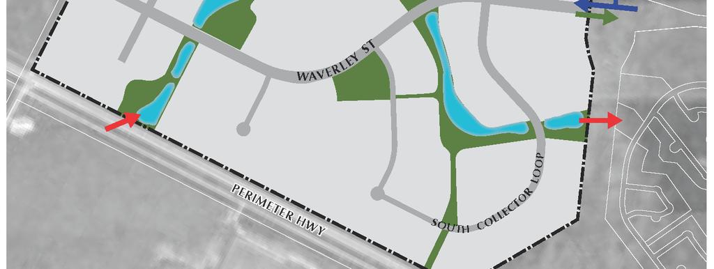
32 Map 4 Infrastructure Page 29 of 38
33 7.1.3 Alignments (1) Utility alignments should generally comply with the standards adopted by the Underground Structures Committee. (2) A developer may be required to provide, or enter into an agreement to provide, rights-of-way or easements that are necessary to accommodate the extension of municipal infrastructure through or adjacent to a site in advance of development in order to allow for the servicing of the site. (3) A developer may be required to finance, or enter into an agreement to finance when required, the costs associated with the extension of municipal infrastructure through or adjacent to a site in advance of development in order to allow for the servicing of a site. 7.2 Water Distribution Intent To provide a water distribution system for the Southwest Neighbourhood and beyond. The Southwest Neighbourhood will be served by extension of the existing feedermain located within the Waverley Street right-of-way which will be extended westerly as development progresses. A future extension of the feedermain from the northern portion of Waverley West, following the Kenaston Boulevard alignment, will provide additional service during later phases of development. Policies Design The water distribution system shall be designed to adequately and efficiently serve the ultimate development of the south western portion of Waverley West Analysis As part of the initial Development Application, the developer shall submit water servicing criteria including a water distribution analysis along with current development phasing plans to demonstrate that any future development sites can be serviced in accordance with the overall design of the water distribution system. Page 30 of 38
34 7.3 Wastewater Collection Intent To provide a wastewater collection system for the Southwest Neighbourhood and beyond. The Southwest Neighbourhood will be serviced by the extension of the Interceptor Sewer along Waverley Street as development progresses Design The wastewater collection system shall be designed to adequately and efficiently serve the ultimate development of the south western portion of Waverley West Analysis As part of the initial Development Application, the developer shall submit wastewater servicing criteria to demonstrate that the development can be serviced in accordance with the overall design of the wastewater collection system. 7.4 Land Drainage System Intent To guide the design and development of a land drainage system to manage stormwater runoff from the Southwest Neighbourhood, Kenaston Boulevard and the Provincial drain. Stormwater management plans will be prepared in accordance with the Regional Land Drainage Plan that provides for an integrated network of land drainage facilities. Stormwater will be detained in a linear retention system consisting of a series of small basins connected by an open channel for conveyance. Water will ultimately be released into the Southeast Neighbourhood land drainage system in accordance with predetermined discharge rates. The land drainage system will be an aesthetically appealing system that will be constructed to replicate a natural functioning wetland and watercourse, provide a unique environment for wildlife, and provide necessary land drainage protection. Some of the advantages of naturalized channel and basin systems include: The reintroduction of native grasses, aquatic plants, trees and other vegetation; The creation of wildlife habitat; The creation of a system that will reduce the nuisance associated with geese; Better water quality by filtering and cleaning surface runoff; Lower long term maintenance costs; Better opportunities for recreation by incorporating and linking the land drainage system with parks and pathways; and Page 31 of 38
35 Opportunities for education regarding the importance of natural systems and habitats. The proposed land drainage system will deviate from the conventional lake and pipe system and will achieve the goals and requirements contemplated by the established policies and guidelines. The location, size and configuration of the facilities will be determined at the Development Application stage. Policies Design (1) The land drainage system shall be designed to adequately and efficiently provide land drainage protection for the Southwest Neighbourhood and an existing Provincial drain. (2) Water from the Provincial drain shall be redirected into the land drainage system. The City shall transfer the existing drain to the developer as part of the initial Development Application in accordance to the process previously established and undertaken to transfer a portion of the Provincial drain in the Southeast Neighbourhood of Waverley West. (3) The land drainage system shall be designed to reduce the impact on the regional infrastructure system and as a linear park and pathway system that also serves as a connection through the Southwest Neighbourhood. (4) As part of the initial Development Application, the developer shall submit land drainage servicing criteria including a stormwater management plan consistent with the intent of the Regional Land Drainage Plan to demonstrate that the development can be serviced by the proposed land drainage system. (5) The land drainage system shall manage stormwater runoff based on established hydraulic requirements in an environmentally sound manner in order to minimize the impact on surrounding lands and downstream reaches. (6) The land drainage system should be planted with a variety of native plant species including aquatic vegetation, grasses, flowers, shrubs and trees to replicate a natural environment and to provide a variety of different treatments. (7) In order to create the Greenway System (see also section 5.6.2), some of the land used to create the wetlands may extend into the parkland/public reserve and therefore would be given dedication credit as part of the public reserve land dedication calculation. (8) Land included for dedication as Public Reserve shall include shoreline at normal water level adjacent to only the public portion of the Greenway System (see also subsection 5.6.6). Page 32 of 38
36 (9) Pathways may be adjacent to the land drainage system for recreational purposes and may be located within lands dedicated for parkland/public reserve (see also subsections 5.6.3) Cost Sharing The City of Winnipeg shall establish an area charge for the Southwest Neighbourhood to effect an equitable sharing of all developer costs among all landowners for the land drainage system. Page 33 of 38
37 8.0 IMPLEMENTATION 8.1 Phasing Intent To provide certainty for the City of Winnipeg that major infrastructure is appropriately provided as development proceeds. Policy Phasing of development will be largely driven by market conditions and by the extension of municipal services The proposed phasing plan illustrated in Map 5 is conceptual and for information purposes only. Extension of services shall occur in a logical and contiguous fashion as determined through the Development Application process. Changes in the phasing plan should be mutually agreed to by both the City of Winnipeg and the developer and do not require formal amendment to the Plan A traffic review shall be submitted with the initial Development Application The phasing plan and traffic review shall be reviewed and updated as needed with subsequent Development Applications in order to determine the timing, design and upgrading of any major roads that are required to service development Transportation area charges shall be reviewed and updated with each Development Application The registration of plans of subdivision and zoning may be carried out as development progresses. The initial plan of subdivision and zoning shall include registration of the following: (1) all roadway alignments; (2) all public lands including land dedicated for parks and open space and the land drainage system; (3) any potential school reserve; and (4) all lands zoned for residential use within the first stage. Zoning for all remaining lands will be implemented in a phased manner as development progresses as generally illustrated in Map 5 Page 34 of 38


38 MAP 5: Phasing Page 35 of 38
THE CITY OF WINNIPEG. TRANSCONA WEST AREA STRUCTURE PLAN BY-LAW NO. 215/2006, as amended
 THE CITY OF WINNIPEG BY-LAW NO. 215/2006, as amended A By-law of THE CITY OF WINNIPEG to adopt a Secondary Plan for the Transcona West Neighbourhood. THE CITY OF WINNIPEG, in Council assembled, enacts
THE CITY OF WINNIPEG BY-LAW NO. 97/2014
 THE CITY OF WINNIPEG BY-LAW NO. 97/2014 A By-law of THE CITY OF WINNIPEG to adopt a secondary plan for Precinct E of the Complete Communities Direction Strategy By-law No. 68/2010. THE CITY OF WINNIPEG,
THE CITY OF WINNIPEG BY-LAW NO. 48/2014
 THE CITY OF WINNIPEG BY-LAW NO. 48/2014 A By-law of THE CITY OF WINNIPEG to adopt a secondary plan for Precinct K of the Complete Communities Direction Strategy By-law No. 68/2010. THE CITY OF WINNIPEG,
North Oakville East Parks Facilities Distribution Plan. November, 2009
 North Oakville East November, 2009 POLICY CONTEXT 1) Purpose a) The purpose of this document is to be a guide for the location, configuration, design and development of the parks system for the North Oakville
Planning, Property and Development Department Report. To the Riel Community Committee
 Planning, Property and Development Department Report To the Riel Community Committee Date: October 30, 2006 File: SP 5/2006 Subject: Waverley West Northeast Neighbourhood Area Structure Plan Location:
Auburn Bay Community Plan
 Auburn Bay Community Plan Auburn Bay Community Plan Office Consolidation June 2007 Bylaw 15P2003 Approved January 19, 2004 Note: This office consolidation includes the following amending Bylaws: Amendment
Westwind Developments Ltd. PIONEER LANDS AREA STRUCTURE PLAN - PROPOSED AMENDMENT
 FEBRUARY 2013 TABLE OF CONTENTS 1.0 BACKGROUND... 1 1.1 Amendment... 1 2.0 LOCATION & CONTEXT... 2 2.1 Land Ownership... 2 3.0 POLICY CONTEXT... 3 3.1 Municipal Development Plan... 3 3.2 Capital Region
Complete Neighbourhood Guidelines Review Tool
 Complete Neighbourhood Guidelines Review Tool Prepared By: City of Regina Planning Department October 2014 Page 1 of 14 Community Development Review Checklist for Secondary Plans and Concept Plans The
S o u t h C e n t r a l O u t l i n e P l a n. Leduc Business Park. North Leduc Industrial Area Structure Plan C it y of Led u c.
 Leduc Business Park North Leduc Industrial Area Structure Plan C it y of Led u c Prepared for Farm Air Properties Inc. January, 2007 Table of Contents Page Number 1.0 Purpose of Plan and Definition of
ARTICLE 6: Special and Planned Development Districts
 ARTICLE 6: Special and Planned Development Districts 6-10 Traditional Neighborhood Development (TND) District 6-10.10 Purpose and Intent The Traditional Neighborhood Development (TND) District provides
The West Vaughan Employment Area Secondary Plan Policies
 Part 2: The West Vaughan Employment Area Secondary Plan Policies 2.1 General Policies It is the policy of Council: 2.1.1. That the West Vaughan Employment Area (the WVEA), identified on Schedule 1, will
RECREATION AND OPEN SPACE ELEMENT GOALS, OBJECTIVES, AND POLICIES
 RECREATION AND OPEN SPACE ELEMENT GOALS, OBJECTIVES, AND POLICIES Goal 7 To provide park facilities, recreation programs, and open space resources that are safe, adequate, and accessible to all City residents,
ELMVALE ACRES SHOPPING CENTRE MASTER PLAN
 ELMVALE ACRES SHOPPING CENTRE MASTER PLAN Contents 1.0 INTRODUCTION... 2 2.0 LOCATION... 2 3.0 EXISTING CONTEXT... 2 4.0 VISION & GUIDING PRINCIPLES... 2 5.0 LAND USE AND BUILT FORM... 4 5.1 St. Laurent
11.4 Highway 400 North Employment Lands Secondary Plan APPROVED BY THE ONTARIO MUNICIPAL BOARD ON NOVEMBER 21, 2011
 11.4 Highway 400 North Employment Lands Secondary Plan APPROVED BY THE ONTARIO MUNICIPAL BOARD ON NOVEMBER 21, 2011 11.4.1 General 11.4.1.1. as approved by the Ontario Municipal Board on November 21, 2011,
OP Council Resolution June 16, Planning and Development Services
 OP-08-01 Council Resolution June 16, 2008 Planning and Development Services Kingsgate Landing Outline Plan Table of Contents 1.0 Introduction 1 1.1 Purpose of Plan 1 1.2 Plan Area Location 1 1.3 Ownership
PORT WHITBY COMMUNITY
 PORT WHITBY COMMUNITY SECONDARY PLAN UPDATE COMMUNITY IMPROVEMENT PLAN URBAN DESIGN GUIDELINES September 2015 DRAFT PROPOSED AMENDMENT NUMBER # to the Whitby Official Plan PURPOSE: The intent of this Amendment
GATEWAY AREA STRUCTURE PLAN
 CHESTERMERE GATEWAY AREA STRUCTURE PLAN COMMUNITY OPEN HOUSE SEPTEMBER 22 nd, 2015 PLAN AREA ± 512 hectares (± 1,265 acres) GATEWAY LOCATION UNDEVELOPED LANDS PRESENT AGRICULTURAL USE REGIONAL LAND USE
Outline Plan in Belvedere (Ward 9) at Street SE, LOC (OP)
 at Street SE, LOC (OP)") 2018 October 04 Page 1 of 12 EXECUTIVE SUMMARY This outline plan application was submitted by B&A Planning Group on 2016 July 15, on behalf of Tristar Communities Inc. for 50.14 hectares (123.89 acres)
2018 October 04 Page 1 of 12 EXECUTIVE SUMMARY This outline plan application was submitted by B&A Planning Group on 2016 July 15, on behalf of Tristar Communities Inc. for 50.14 hectares (123.89 acres)
AREASTRUCTURE PLAN AMENDMENT COCHRANE NORTH
 AREASTRUCTURE PLAN AMENDMENT COCHRANE NORTH In order to implement the vision outlined in the Conceptual Scheme, the following three amendments to the Cochrane North ASP are proposed: 1. Allow commercial
Welcome. Walk Around. Talk to Us. Write Down Your Comments
 Welcome This is an information meeting introducing the applications for proposed redevelopment of the Yorkdale Shopping Centre site at 3401 Dufferin Street and 1 Yorkdale Road over the next 20+ years,
[PLANNING RATIONALE] For Site Plan Control and Lifting of Holding Zone By-Law 101 Champagne Avenue. May 23, 2014
![[PLANNING RATIONALE] For Site Plan Control and Lifting of Holding Zone By-Law 101 Champagne Avenue. May 23, 2014](/thumbs/75/71599615.jpg "[PLANNING RATIONALE] For Site Plan Control and Lifting of Holding Zone By-Law 101 Champagne Avenue. May 23, 2014") [PLANNING RATIONALE] For Site Plan Control and Lifting of Holding Zone By-Law 101 Champagne Avenue May 23, 2014 Contents 1.0 Introduction... 2 2.0 Site Context... 2 2.1 Adjacent Uses... 2 Figure 1: Site
[PLANNING RATIONALE] For Site Plan Control and Lifting of Holding Zone By-Law 101 Champagne Avenue May 23, 2014 Contents 1.0 Introduction... 2 2.0 Site Context... 2 2.1 Adjacent Uses... 2 Figure 1: Site
HURON COMMUNITY PLAN
 CITY OF KITCHENER DEPARTMENT OF DEVELOPMENT AND TECHNICAL SERVICES PD 94/7 HURON COMMUNITY PLAN Recommended by Planning and Economic Development Committee: October 31, 1994 Adopted by Kitchener City Council:
URBAN DESIGN BRIEF URBAN DESIGN BRIEF 721 FRANKLIN BLVD, CAMBRIDGE August 2018
 URBAN DESIGN BRIEF URBAN DESIGN BRIEF 721 FRANKLIN BLVD, CAMBRIDGE August 2018 DESIGN BRIEF CONTENTS PART A 1.0 INTRODUCTION 2.0 DESCRIPTION & ANALYSIS OF SITE CONTEXT 3.0 DESIGN CONSTRAINTS AND OPPORTUNITIES
9 CITY OF VAUGHAN OFFICIAL PLAN AMENDMENT NO BOCA EAST INVESTMENTS LIMITED
 9 CITY OF VAUGHAN OFFICIAL PLAN AMENDMENT NO. 631 - BOCA EAST INVESTMENTS LIMITED The Planning and Economic Development Committee recommends the adoption of the recommendations contained in the following
AMENDMENT NO. 38 TO THE CITY OF BARRIE OFFICIAL PLAN SALEM SECONDARY PLAN. June 2014
 AMENDMENT NO. 38 TO THE CITY OF BARRIE OFFICIAL PLAN SALEM SECONDARY PLAN June 2014 AMENDMENT NO. 38 TO THE OFFICIAL PLAN OF THE BARRIE PLANNING AREA TABLE OF CONTENTS Page Introduction 1 Part A - The
FORMER CANADIAN FORCES BASE (CFB) ROCKCLIFFE SECONDARY PLAN. Official Plan Amendment XX to the Official Plan for the City of Ottawa
 ROCKCLIFFE SECONDARY PLAN. Official Plan Amendment XX to the Official Plan for the City of Ottawa") FORMER CANADIAN FORCES BASE (CFB) ROCKCLIFFE SECONDARY PLAN Official Plan Amendment XX to the Official Plan for the City of Ottawa 1 INDEX THE STATEMENT OF COMPONENTS PART A THE PREAMBLE PAGE Purpose...
FORMER CANADIAN FORCES BASE (CFB) ROCKCLIFFE SECONDARY PLAN Official Plan Amendment XX to the Official Plan for the City of Ottawa 1 INDEX THE STATEMENT OF COMPONENTS PART A THE PREAMBLE PAGE Purpose...
DAVENPORT VILLAGE SECONDARY PLAN
 27 DAVENPORT VILLAGE SECONDARY PLAN 27. DAVENPORT VILLAGE SECONDARY PLAN 1. VISION FOR THE DAVENPORT VILLAGE SECONDARY PLAN Davenport Village, municipally known as 830, 940, 980 and 1100 Lansdowne Avenue,
Mark-up of the effect of the proposed Bronte Village Growth Area OPA No.18 on the text of section 24, Bronte Village, of the Livable Oakville Plan
 Mark-up of the effect of the proposed Bronte Village Growth Area OPA No.18 on the text of section 24, Bronte Village, of the Livable Oakville Plan Notes: This document is provided for information purposes
11.4 Highway 400 North Employment Lands Secondary Plan
 11.4 Highway 400 North Employment Lands Secondary Plan APPROVED BY THE ONTARIO MUNICIPAL BOARD ON NOVEMBER 21, 2011 11.4.1 General 11.4.1.1. The following policies and Schedules A - I form Official Plan
Table 8-4: Road Classification Local Roads, second table, of Chapter 8 Create a Multi-Modal City, be amended by adding the following:
 1 Port Street East Official Plan Amendment APPENDIX 3 Amendments to Mississauga Official Plan Table 8-4: Road Classification Local Roads, second table, of Chapter 8 Create a Multi-Modal City, be amended
AMENDMENT NO. TO THE CITY OF BARRIE OFFICIAL PLAN HEWITT S SECONDARY PLAN
 AMENDMENT NO. TO THE CITY OF BARRIE OFFICIAL PLAN HEWITT S SECONDARY PLAN OFFICIAL PLAN FOR THE CITY OF BARRIE Amendment No. Amendment No. to the was prepared by the Barrie General Committee and was recommended
5.0 Community Design Plan
 5.0 Community Design Plan The Community Design Plan for the Mer Bleue area is a composite of three plans: Land Use Plan Transportation Plan Municipal Servicing Plan Read together, these Plans and associated
Mitchell Ranch South MPUD Application for Master Planned Unit Development Approval Project Narrative. Introduction
 Mitchell Ranch South MPUD Application for Master Planned Unit Development Approval Project Narrative Introduction Mitchell Ranch South is a proposed single family (detached) residential development on
LAND USE AMENDMENT CORNERSTONE (WARD 3) 60 STREET NE AND COUNTRY HILLS BOULEVARD NE MAP 26NE BYLAW 22D2017
 60 STREET NE AND COUNTRY HILLS BOULEVARD NE MAP 26NE BYLAW 22D2017") Page 1 of 14 EXECUTIVE SUMMARY This Land Use Amendment application covers an area of 43.76 hectares ± (108.14 acres ±) located in northeast Calgary, bound by Country Hills Boulevard NE to the south and
Page 1 of 14 EXECUTIVE SUMMARY This Land Use Amendment application covers an area of 43.76 hectares ± (108.14 acres ±) located in northeast Calgary, bound by Country Hills Boulevard NE to the south and
and services The protection and conservation of environmentally significant and sensitive natural heritage features and functions.
 6. Land Use 6.0 Preamble A healthy and livable city is one in which people can enjoy a vibrant economy and a sustainable healthy environment in safe, caring and diverse neighbourhoods. In order to ensure
Urban Design Brief December 23, 2015 Southside Construction Group Official Plan & Zoning By-Law Amendment
 Urban Design Brief Proposed Official Plan & Zoning By-Law Amendment 3244, 3263 and 3274 Wonderland Road South Southside Group December 23, 2015 TABLE OF CONTENTS Page No. INTRODUCTION... 1 SECTION 1 LAND
HAMLET OF KINGMAN AREA STRUCTURE PLAN
 HAMLET OF KINGMAN AREA STRUCTURE PLAN Prepared by: Austrom Consulting Ltd. Page 1 of 19 Table of Contents TABLE OF CONTENTS... 2 1. BACKGROUND... 3 1.1 PLAN AREA... 3 1.2 PLAN PURPOSE... 3 1.3 LEGISLATIVE
SECTION E. Realizing the Plan
 SECTION E Realizing the Plan 60 DESIGN REGINA - OFFICIAL COMMUNITY PLAN SECTION E Realizing the Plan Design Regina has been an ambitious plan-making exercise, with a high level of community, stakeholder,
CONTENTS 8.0 LAND USE 8.1 GENERAL LAND USE 8.2 RESIDENTIAL 8.3 MIXED USE 8.4 COMMERCIAL 8.5 EMPLOYMENT LANDS
 8-2 Land Use 8.0 LAND USE CONTENTS 8.1 GENERAL LAND USE 8.1.1 Uses provided for in all Land Use Designations 8.1.2 Uses prohibited in Hazardous Lands, Hazardous Sites and Special Policy Areas 8.1.3 Uses
THE CITY OF VAUGHAN BY-LAW BY-LAW NUMBER A By-law to adopt Amendment Number 1 to the Official Plan of the Vaughan Planning Area.
 THE CITY OF VAUGHAN BY-LAW BY-LAW NUMBER 015-2014 A By-law to adopt Amendment Number 1 to the Official Plan of the Vaughan Planning Area. NOW THEREFORE the Council of the Corporation of the City of Vaughan
6 Growth Management Challenges and Opportunities
 6 Growth Management Challenges and Opportunities The Town has established a goal of attaining a 50% participation rate with respect to employment opportunities versus residential population. The Town s
Leduc Industrial Outline Plan SE W4
 Leduc Industrial Outline Plan SE 1-50-25-W4 Within the North Leduc Industrial ASP Prepared for: Leduc Energy Park Ltd. Prepared by: Stantec Consulting Ltd. File No. 1161 104655 V5 Table of Contents 1.0
AWH REPORT OF THE PLANNING AND DEVELOPMENT DEPARTMENT FOR APPLICATION FOR REZONING ORDINANCE TO PLANNED UNIT DEVELOPMENT
 AWH REPORT OF THE PLANNING AND DEVELOPMENT DEPARTMENT FOR APPLICATION FOR REZONING ORDINANCE TO PLANNED UNIT DEVELOPMENT MAY 8, 2014 The Planning and Development Department hereby forwards to the Planning
Derry Green Corporate Business Park
 Town of Milton Derry Green Corporate Business Park Urban Design Guidelines BMI/Pace - June 2010 Draft 3 Prepared by: Brook McIlroy Planning + Urban Design / Pace Architects Suite 300-51 Camden Street Toronto,
City of Grande Prairie Development Services Department
 City of Grande Prairie Development Services Department ROYAL OAKS NORTH OUTLINE PLAN OP-07-03 NW 35-71-6 W6M May 7, 2007 Royal Oaks North Outline Plan TABLE OF CONTENTS 1.0 INTRODUCTION........ 3 1.1 Purpose
FROM: General Manager, Planning and Development FILE: (North Grandview Heights)
") Corporate NO: C009 Report COUNCIL DATE: May 18/05 COUNCIL-IN-COMMITTEE TO: Mayor & Council DATE: May 12, 2005 FROM: General Manager, Planning and Development FILE: 6520-20 (North Grandview Heights) SUBJECT:
Corporate NO: C009 Report COUNCIL DATE: May 18/05 COUNCIL-IN-COMMITTEE TO: Mayor & Council DATE: May 12, 2005 FROM: General Manager, Planning and Development FILE: 6520-20 (North Grandview Heights) SUBJECT:
Red Fox Commercial Outline Plan
 Red Fox Commercial Outline Plan City of Cold Lake, Alberta Prepared by Durrance Projects Ltd and Ross W. Sharp & Associates Ltd October 2014 Rupert 1 Table of Contents 1. PURPOSE...3 1.1. Location...4
4.1.3 LAND USE CATEGORIES
 4.1.3 LAND USE CATEGORIES a. City Center District The City Center District incorporates the existing character and mix of uses in downtown Belmont to encourage redevelopment and new development in keeping
STATEMENT OF JUSTIFICATION CLARKSBURG PREMIUM OUTLETS AT CABIN BRANCH NORTH DISTRICT, PHASE
 STATEMENT OF JUSTIFICATION CLARKSBURG PREMIUM OUTLETS AT CABIN BRANCH NORTH DISTRICT, PHASE 1 Southwest Corner of Clarksburg Road and Interstate-270 Clarksburg, Maryland Application for Site Plan #820140160
Inform you of the purpose and scope of the study for PTH 100 and a proposed future St. Norbert Bypass;
 WELCOME The intent of today s Open House is to: Inform you of the purpose and scope of the study for PTH 100 and a proposed future St. Norbert Bypass; Review highway crossing locations, future access closures
OFFICE CONSOLIDATION SECONDARY PLAN AREA 22 THE BRAMALEA SOUTH INDUSTRIAL SECONDARY PLAN
 OFFICE CONSOLIDATION SECONDARY PLAN AREA 22 THE BRAMALEA SOUTH INDUSTRIAL SECONDARY PLAN November 2010 EXPLANATORY NOTES (Secondary Plan Area 22) General (pertaining to all secondary plan office consolidations)
I615. Westgate Precinct
 I615. Westgate Precinct I615.1. Precinct Description The Westgate Precinct is located approximately 18km west of the Auckland city centre. There are seven Sub-precincts in the Westgate Precinct: Sub-precinct
Stanley Greene District Downsview (80 Carl Hall Road) Zoning By-law Amendment and Draft Plan of Subdivision Applications Request for Direction Report
 Zoning By-law Amendment and Draft Plan of Subdivision Applications Request for Direction Report") STAFF REPORT ACTION REQUIRED Stanley Greene District Downsview (80 Carl Hall Road) Zoning By-law Amendment and Draft Plan of Subdivision Applications Request for Direction Report Date: December 16, 2011
STAFF REPORT ACTION REQUIRED Stanley Greene District Downsview (80 Carl Hall Road) Zoning By-law Amendment and Draft Plan of Subdivision Applications Request for Direction Report Date: December 16, 2011
City of Grande Prairie Development Services Department KENNEDY DEVELOPMENTS LTD. OUTLINE PLAN OP-09-01
 City of Grande Prairie Development Services Department KENNEDY DEVELOPMENTS LTD. OUTLINE PLAN OP-09-01 July 27, 2009 TABLE OF CONTENTS 1.0 Introduction... 1 1.1 Plan Area Location & Context... 1 1.2 Ownership
CITY PLANNING COMMISSION AGENDA ITEM: C STAFF: ROBERT TEGLER FILE NO: CPC PUD QUASI-JUDICIAL
 CPC AGENDA June 8, 2006 Page 37 CITY PLANNING COMMISSION AGENDA ITEM: C STAFF: ROBERT TEGLER FILE NO: CPC PUD 05-294 - QUASI-JUDICIAL PROJECT: APPLICANT: OWNER: PARKWOOD AT WOLF RANCH NASS DESIGN ASSOCIATES
East Bayshore Road Neighbourhood
 East Bayshore Road Neighbourhood Northridge Property Management Urban Design Brief 3195 East Bayshore Road City of Owen Sound January 2016 East Bayshore Road Neighbourhood Northridge Property Management
6.0 Land Use Policies for Rural Settlements. 6.1 Rural Settlement Strategy
 6.0 Land Use Policies for Rural Settlements 6.1 Rural Settlement Strategy INTRODUCTION AMENDMENT NO. 131 PURPOSE Designated rural settlements comprise Rural Clusters, Villages and Serviced Villages as
3. VISION AND GOALS. Vision Statement. Goals, Objectives and Policies
 Vision Statement Queen Creek s interconnected network of parks, trails, open spaces and recreation opportunities provide safe and diverse activities and programs that sustain its unique, small town, equestrian
Staff Report and Recommendation
 Community Planning and Development Planning Services 201 W. Colfax Ave., Dept. 205 Denver, CO 80202 p: 720.865.2915 f: 720.865.3052 www.denvergov.org/cpd TO: City Council Neighborhoods and Planning Committee
4.11 Town Centre Secondary Plan (Former City of Cumberland)
") 4.11 Town Centre Secondary Plan (Former City of Cumberland) 4.11.1 Town Centre Objectives 4.11.1.1 Introduction The reason for the preparation of this Secondary Plan for the Town Centre is as follows:
4.11 Town Centre Secondary Plan (Former City of Cumberland) 4.11.1 Town Centre Objectives 4.11.1.1 Introduction The reason for the preparation of this Secondary Plan for the Town Centre is as follows:
Bylaw C-1186 Adopted November 5, Planning and Development Services
 Bylaw C-1186 Adopted November 5, 2007 Planning and Development Services CITY OF GRANDE PRAIRIE OFFICE CONSOLIDATION BYLAW C-1186 A Bylaw to adopt the Westgate Area Structure Plan (As Amended by Bylaw C-1186-1,
Waverley West B Secondary Planning Process. Open House South Pointe School April 25, 2018
 averley est B Secondary Planning Process South Pointe School April 25, 2018 averley est B Secondary planning process open house Please review the boards and provide your feedback. 1 The Role of a Secondary
DOMINION BOULEVARD CORRIDOR STUDY AND ECONOMIC DEVELOPMENT STRATEGIC PLAN A MODEL FOR CHESAPEAKE S FUTURE
 DOMINION BOULEVARD CORRIDOR STUDY AND ECONOMIC DEVELOPMENT STRATEGIC PLAN A MODEL FOR CHESAPEAKE S FUTURE Overview I. Draft Plan Process II. Draft Plan Overview a. Market Analysis b. Master Land Use Plan
6. REGIONAL AND COMMUNITY FACILITIES DESIGNATIONS 6.1. OBJECTIVES FOR REGIONAL AND COMMUNITY FACILITIES LAND USE DESIGNATIONS
 6. REGIONAL AND COMMUNITY FACILITIES DESIGNATIONS INTRODUCTION The Regional and land use designations provide the primary locations for uses which satisfy the health, education and other service needs
THE NEW COMMUNITY PLANNING GUIDEBOOK
 MUNICIPAL DEVELOPMENT PLAN: VOLUME 2, PART 1 THE NEW COMMUNITY PLANNING GUIDEBOOK Adopted by Council [Approval Date] calgary.ca contact 311 Onward/ We will create great communities with quality living
BYLAW C A Bylaw of Rocky View County to amend Land Use Bylaw C
 BYLAW C-7720-2017 A Bylaw of Rocky View County to amend Land Use Bylaw C-4841-97. The Council of Rocky View County enacts as follows: PART 1 TITLE This Bylaw shall be known as Bylaw C-7720-2017. PART 2
Further input invited as Colchester Growth Strategy nears final phase
 IUE 3 / NOVEMBER 2015 Further input invited as Colchester Growth trategy nears final phase trathcona County is seeking public feedback as it enters the final phase of work on a Growth Management trategy
Agenda Standing Policy Committee on Infrastructure Renewal and Public Works January 31, 2013 REPORTS
 Agenda Standing Policy Committee on Infrastructure Renewal and Public Works January 31, 2013 REPORTS Item No. 1 Amendment of the Transportation Master Plan to Reflect the Recommendation of the Southwest
Bloor St. W. Rezoning - Preliminary Report
 STAFF REPORT ACTION REQUIRED 1638-1644 Bloor St. W. Rezoning - Preliminary Report Date: April 1, 2008 To: From: Wards: Reference Number: Toronto and East York Community Council Acting Director, Community
Municipal Development Plan. Summer Village of ROCHON SANDS. Bylaw #241-18
 Municipal Development Plan Summer Village of ROCHON SANDS Bylaw #241-18 TABLE OF CONTENTS PART ONE: BACKGROUND AND PURPOSE 3 SECTION 1: BACKGROUND 3 SECTION 2: GOALS AND POLICIES 3 PART TWO: PHYSICAL ENVIRONMENT
Description of Preferred Alternative
 Chapter 2 Description of Preferred Alternative 2.1 Introduction This chapter of the programmatic Sammamish Town Center Sub-area Plan Final EIS provides a more detailed description of the Preferred Alternative
WEST HILL BUSINESS PARK AREA STRUCTURE PLAN
 MUNICIPAL DISTRICT OF PEACE NO. 135 WEST HILL BUSINESS PARK AREA STRUCTURE PLAN Prepared by: TABLE OF CONTENTS 1.0 Introduction... 1 1.1 Purpose of Plan........ 1 1.2 Plan Area..... 1 1.3 Existing Conditions...
ADMINISTRATION RECOMMENDATION 2016 November 03. That Calgary Planning Commission recommends APPROVAL of the proposed Land Use Amendment.
 Page 1 of 12 EXECUTIVE SUMMARY This Land Use Amendment application covers an area of 75.76 hectares ± (187.20 acres ±) located in northeast Calgary, bound by Stoney Trail NE to the north, 128 Avenue NE
Executive Summary. NY 7 / NY 2 Corridor
 Executive Summary NY 7 / NY 2 Corridor Transportation and Land Use Study December 2005 Prepared for: Town of Colonie Capital District Transportation Committee Prepared by: Introduction: Land use decisions
COMMUNITY DESIGN. GOAL: Create livable and attractive communities. Intent
 COMMUNITY DESIGN Intent An attractive, well-designed County will attract quality development, instill civic pride, improve the visual character of the community, and create a strong, positive image for
The Corporation of the TOWN OF MILTON
 Report to: From: Chair & Members of the Administration & Planning Standing Committee W.F. Mann, Director of Planning and Development Date: April 16, 2012 PD 022-12 (Z19/11) Subject: Technical Report Proposed
Planned Residential Neighborhoods Land Use Goals
 Planned Residential Neighborhoods Land Use Goals Issue: Guidelines that provide for diverse high quality residential areas that include a variety of housing styles and layouts are needed. Goal 1: Create
Municipal Development Plan Update Urban Service Area and Hamlets
 ENCLOSURE 1 Municipal Development Plan Update Urban Service Area and Hamlets Priorities Committee January 24, 2017 MUNICIPAL DEVELOPMENT PLAN UPDATE SHAPING OUR FUTURE MDP Update - Agenda MDP Update Public
City of Toronto. Emery Village Transportation Master Plan
 City of Toronto Emery Village Transportation Master Plan May 2009 Emery Village Transportation Master Plan Toronto, ON May 2009 Consulting Inc. 100 York Blvd., Suite 300 Richmond Hill, ON L4B 1J8 Tel:
Bylaw C-1262 Adopted February 6, Planning and Development Department
 Bylaw C-1262 Adopted February 6, 2012 Planning and Development Department CITY OF GRANDE PRAIRIE BYLAW C-1262 A Bylaw to adopt the Brookfield Neighbourhood Outline Plan THE MUNICIPAL COUNCIL OF THE CITY
THAT the attached Terms of Reference for the Thornhill Centre Street Study be approved.
 COMMITTEE OF THE WHOLE AUGUST 18, 2003 THORNHILL CENTRE STREET STUDY PLANNING FILE: 15.92 Recommendation The Commissioner of Planning recommends: THAT the attached Terms of Reference for the Thornhill
12 AMENDMENT NO. 149, TOWN OF MARKHAM HIGHWAY 404 NORTH SECONDARY PLAN
 12 AMENDMENT NO. 149, TOWN OF MARKHAM HIGHWAY 404 NORTH SECONDARY PLAN The Planning and Economic Development Committee recommends the adoption of the recommendation contained in the following report August
C ity of Grande Prairie Development Services Department
 C ity of Grande Prairie Development Services Department FAIRWAY DEVELOPMENT OUTLINE PLAN OP 08 09 Approved April 6, 2009 Prepared by: Focus Corporation Table of Contents 1.0. Introduction 2 3 1.1. Plan
DRAFT Northeast Quadrant of Kipling Avenue and Highway 7 DRAFT AUGUST 29, Goals Land Use. The goals of this Plan are to:
 AUGUST 29, 2017 12.15 Northeast Quadrant of Kipling Avenue and Highway 7 12.15.1 Goals 12.15.2 Land Use The goals of this Plan are to: 12.15.2.1 General Provisions: a) Ensure the development of a compact
3 Development Process 3.1 Stage One page Stage Two page Stage Three page CENTRAL PICKERING DEVELOPMENT PLAN
 3 Development Process 3.1 Stage One page 24 3.2 Stage Two page 25 3.3 Stage Three page 28 22 CENTRAL PICKERING DEVELOPMENT PLAN The Central Pickering Development Plan establishes the key elements of new
13 THORNHILL YONGE STREET STUDY IMPLEMENTATION CITY OF VAUGHAN OPA 669 AND TOWN OF MARKHAM OPA 154
 13 THORNHILL YONGE STREET STUDY IMPLEMENTATION CITY OF VAUGHAN OPA 669 AND TOWN OF MARKHAM OPA 154 The Planning and Economic Development Committee recommends the adoption of the recommendations contained
THE CORPORATION OF THE TOWN OF OAKVILLE BY-LAW NUMBER
 THE CORPORATION OF THE TOWN OF OAKVILLE BY-LAW NUMBER 20012-08530 A by-law to adopt an amendment to the Official Plan of the Oakville Planning Area (Official Plan Amendment 198) Land North of Dundas Street.
12 January 12, 2011 Public Hearing APPLICANT: TAILWIND DEVELOPMENT GROUP,LLC PROPERTY OWNER: CITY OF VIRGINIA BEACH
 12 January 12, 2011 Public Hearing APPLICANT: TAILWIND DEVELOPMENT GROUP,LLC PROPERTY OWNER: CITY OF VIRGINIA BEACH STAFF PLANNER: Faith Christie REQUEST: Conditional Change of Zoning (from PD-H1 Planned
Chapter Master Planned Communities (MPC) District
 District") Sections 14.53.010 Purpose and Intent 14.53.020 Applicability 14.53.030 Procedure 14.53.040 MPC Standards 14.53.050 Required Findings 14.53.010 Purpose and Intent Chapter 14.53 Master Planned Communities
Sections 14.53.010 Purpose and Intent 14.53.020 Applicability 14.53.030 Procedure 14.53.040 MPC Standards 14.53.050 Required Findings 14.53.010 Purpose and Intent Chapter 14.53 Master Planned Communities
SPECIFIC PLAN Requirements
 CITY OF LANCASTER PLANNING DEPARTMENT 44933 Fern Avenue, Lancaster, California 93534 (661) 723-6100 SPECIFIC PLAN Requirements Purpose The purpose of a specific plan is to provide for the logical development
OFFICE CONSOLIDATION CHAPTER 47 HIGHWAY 427 INDUSTRIAL SECONDARY PLAN
 OFFICE CONSOLIDATION CHAPTER 47 HIGHWAY 427 INDUSTRIAL SECONDARY PLAN NOTE: This Secondary Plan is partially in effect. Highlighted sections are under appeal. August 2017 1 EXPLANATORY NOTE Office Consolidation
Report to: Development Services Committee Report Date: April 24, 2017
 SUBJECT: Cornell Rouge National Urban Park Gateway - Report on Design Charrette and Next Steps PREPARED BY: Lilli Duoba, MES, MCIP, RPP, Manager, Natural Heritage (ext. 7925) REVIEWED BY: Marg Wouters,
Gold Line Bus Rapid Transit Transit Oriented Development (BRTOD) Helmo Station Area Plan
 Helmo Station Area Plan") Appendix F Gold Line Bus Rapid Transit Transit Oriented Development (BRTOD) Helmo Station Area Plan Introduction and Purpose of the Plan The Gold Line Bus Rapid Transit facility is an eleven-mile dedicated
Appendix F Gold Line Bus Rapid Transit Transit Oriented Development (BRTOD) Helmo Station Area Plan Introduction and Purpose of the Plan The Gold Line Bus Rapid Transit facility is an eleven-mile dedicated
38 Queen s University Campus Master Plan Part 1
 38 Queen s University Campus Master Plan Part 1 46 The Campus at the City Scale Chapter 4 The Campus at the City Scale 39 Queen s is an urban University centrally located in Kingston. Decisions made by
9 th Street Sub Area Plan
 9 th Street Sub Area Plan In the 1990 s, when the Township prepared the last Master Plan, the 9 th Street corridor was studied as part of a larger 9 th Street Focus Area that included the West Main Street
MAYFIELD WEST SECONDARY PLAN PHASE 2
 MAYFIELD WEST SECONDARY PLAN PHASE 2 Public Open House #3 February 25, 2010 Draft Preferred Land Use Scenario TOWN OF CALEDON PLANNING & DEVELOPMENT DEPARTMENT Open House Agenda TOWN OF CALEDON 1. Welcome
Queensborough Eastern Neighbourhood Node. Community Open House
 Queensborough Eastern Community Open House The Vision The Queensborough Eastern will become the heart of eastern Queensborough. Through a sensitive mix of viable commercial and residential areas, the neighbourhood
SECTION 7A: WHAKARONGO RESIDENTIAL AREA
 SECTION 7A: WHAKARONGO RESIDENTIAL AREA CONTENTS 7A.1 Introduction 1 7A.2 Resource Management Issues 1 7A.3 Objectives and Policies 1 7A.4 Methods 4 7A.5 Residential Zone 4 7A.5.1 Rules: Controlled Activities
Attachment 1 TOWN OF NEW TECUMSETH. Manual for the Preparation of an Urban Design Report
 Attachment 1 TOWN OF NEW TECUMSETH Manual for the Preparation of an Urban Design Report July 2010 TABLE OF CONTENTS Background, Policy Framework and the Preparation of Urban Design Reports 1. Introduction
Urban Design Brief Fanshawe Park Road. Competition Toyota
 Urban Design Brief 1300 Fanshawe Park Road Competition Toyota May 2, 2014 TABLE OF CONTENTS Page No. INTRODUCTION... 1 SECTION 1 LAND USE PLANNING CONTEXT... 1 1.1 The Subject Lands... 1 1.2 The Proposal...