4.00 STAKEHOLDERS. urbanprojects
|
|
|
- Aubrey Higgins
- 5 years ago
- Views:
Transcription
1 4.00 STAKEHOLDERS 94
2 heuston gateway: regeneration strategy and development framework plan 95
3 The Heuston Gateway presents one of the greatest concentrations of brown field development sites located adjacent to the existing city centre remaining in Dublin. It is unique in having the majority of these in the ownership of a small number of public bodies and private sector companies. The sites were examined and analysed through meetings held with the owners of the sites most significant in terms of size and development potential. Outline proposals have been drawn up and are described in the following sections Please note that in this document commercial uses is a general term for non residential uses considered appropriate by the planning authority for that location such as office, retail, hotel, enterprise, educational, entertainment and cultural uses. stakeholders 96

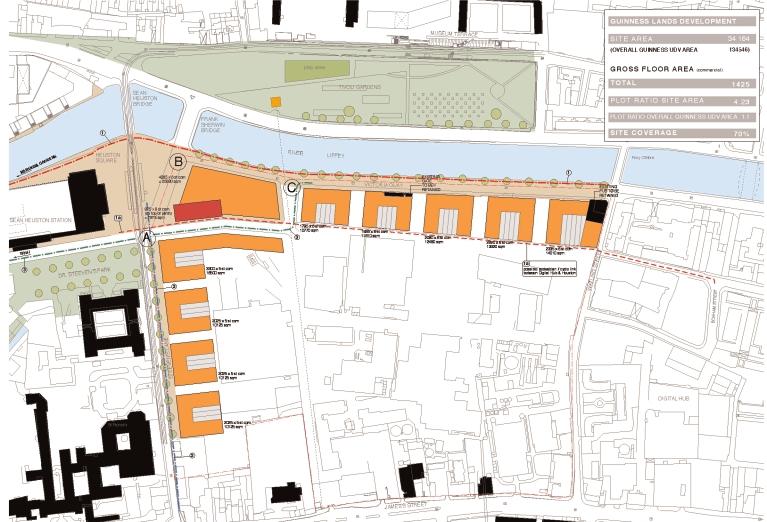
4 4.1 Guinness UDV Site area (sq.m): Development area (sq.m): Gross development capacity (sq.m) Plot Ratio: 4.2 Site Coverage: 70% Present zoning: Z7 Proposed zoning: Z6 / Z5 The Guinness UDV site is key to the development of the overall Heuston Gateway due to its large area and location. Development is subject to Guinness UDV s operational requirements and has been restricted to the three sites along the periphery of the Guinness lands north of St James s Gate described below. Heuston Gateway: stakeholders: Guinness UDV heuston gateway: regeneration strategy and development framework plan 97
5 stakeholders 98
6 4.1.1 Site A: The Caskworks site along Steevens Lane is presently characterised by underused or abandoned buildings. Steevens Lane will soon be solely for use by Luas, pedestrians, cyclists and access only traffic. The site is tucked away from the main public arena at Heuston but has the following potentialities: Proximity to Heuston Station, Phoenix Park, city centre and national institutions Frontage onto quality pedestrian and public transport environment Position opposite the principal façade of an architecturally and historically significant building Dr Steevens Hospital. Location within the Guinness lands which has a precedent for high buildings and no restrictive historical urban grain a suitable location for high density mixed use development. Possible connection to existing road within Guinness lands running from Thomas Street to Victoria Quay. Development on this site should be principally commercial. While residential uses would be preferable in terms of mix of use throughout the area, it is considered impractical in light of the necessity to preserve the manufacturing processes currently carried out on the Guinness lands. The hours of work and noise levels on the Guinness lands is considered unsuitable for adjacent residential development as there might be a risk of injunctions being made against Guinness. If however the nature of work and processes on the Guinness lands change, residential should be considered. 6 storey commercial development in a series of four blocks allowing light and views to and from the Guinness lands is proposed. The northern block must address Dr. Steevens Hospital Park and Heuston Square. This block has a high profile landmark location and should be of the highest architectural standards. This block also provides frontage onto the new westbound access road. The building line should be set back and the development should address the public space of Steevens Lane. The space must be re-designed to provide clear demarcation between Luas lines, vehicular carriageways, cycle-tracks and footpaths (please refer to section 3.3.6). office development Site A a. Commercial building, Munich [Herzog and De Meuron] b. S3 Offices, Dublin [FKL Architects] c. University building, Utrecht [Mecanoo] d. Research Headquarters, Basel [Herzog and De Meuron] a. b. c. d. heuston gateway: regeneration strategy and development framework plan 99
7 4.1.2 Site B: Heuston Square site Site B is at the corner of the Guinness lands opposite Heuston Station. The potentialities of the site are similar to site C (please refer to section 4.1.3). Site B has greater prominence due to aspect onto the river and station. Site B should be the location for a distinctive landmark building with a commercial / cultural use. The development is to be generally six storeys commercial or equivalent. The development should address Heuston Square and Victoria Quay. Principal entry should be from Heuston Square. Part of the Heuston Square site should be the location for a tall structure of appropriate slenderness as indicated. The tall structure must address Heuston Square at street level. The tall structure is one of three proposed tall buildings around Heuston Station. The building will locate the Guinness lands from the wider city. The prominence of this building necessitates the highest architectural design standards and materials. The building should have a high level of transparency. Height, slenderness and transparency are subject to a visual impact assessment. The Guinness lands development lies within the line of visual connection between the axis through the Phoenix Park (Chesterfield Avenue) and the Guinness UDV Brewery. This connection should be maintained. The new tall building will become an element in the view. (Please refer to section ) landmark buildings Site B: a. Potsdamer Platz, Berlin [Renzo Piano] b. GSW Headquarters, Berlin [Sauerbruch Hutton] a. b. stakeholders 100
8 4.1.3 Site C: Victoria Quay Victoria Quay is presently characterised by a wide busy road and the blank wall and main vehicular entrance of the Guinness lands. Victoria Quay is one of the most hostile environments in the area (Please refer to section ). However the site has huge potential due to the: Length of river frontage and potential to continue the built form of the quays Proximity to Heuston Station, Phoenix Park, city centre and national institutions Views over to the Collins Barracks to the north and along the Liffey corridor Prominent position at the gateway to the city centre The more open context of this presently under-developed land justifies an increase in building height. This height should be restricted to allow the profile of the higher Guinness structures near St. James s Gate to be viewed from the north city. A visual impact assessment of any proposed development should be carried out as necessary. Site C should be commercial development of up to six storeys. The buildings will have a hi-profile frontage onto Victoria Quay and accordingly must be of the highest architectural design standard. Development along Victoria Quay should be broken at regular intervals to allow south light onto the Quays and views to and from the Guinness lands. The building line onto Victoria Quay should be adjusted to accommodate generous pedestrian/ cycle amenity. The development should appropriately accommodate 2 listed structures: the original Guinness Gate Lodge and the pub on the corner of Watling Street (please refer to section 4.1.4). The development should allow for the required access between Victoria Quay and the Guinness lands. The development should provide for a new road branching off at Victoria Quay to be in line with St. John s Road as indicated. Pedestrian access to the rear of the new development on Victoria Quay between Watling Street and Heuston Square would provide a direct link between the station and the Digital Hub. commercial development Site C Potsdamer Platz, Berlin [masterplan: Renzo Piano] heuston gateway: regeneration strategy and development framework plan 101


9 4.1.4 Zoning The zoning objective for the Guinness lands must ensure that no development can occur that might restrict in any way the present or future use of the Guinness UDV Brewery. The present Z7 zoning objectives for the Guinness lands are to provide for the protection and creation of industrial uses and facilitate opportunities for employment creation. Office use, the predominant proposed future use, is not within the permitted or open for consideration categories of the present Development Plan. It will therefore be necessary to vary the Development Plan, make a Local Area Plan or await the review of the Development Plan. Offices for the exclusive use of Guinness UDV would be permissible under the present zoning as this can be seen as part of the existing industrial use. The revised zoning in the new Development Plan should state that the Guinness UDV Brewery and all associated activites including production, storage, marketing, distribution and administration, undertaken principally within the James s Street, Watling Street, Victoria Quay, Steeven s Lane precinct, are of major importance to the city, in terms of employment as well as industrial and cultural heritage. The new Development Plan should also state that it is a specific objective of Dublin City Council to ensure the continued operation Guinness UDV industrial activities on these lands and to facilitate their consolidation and expansion as appropriate. Notwithstanding the zoning objective for these lands therefore, any development proposals which would adversely impact on the safe and proper continuation of Guinness UDV operations, will not be permitted. It is proposed to designate the majority of the development site to Z6: to provide for the creation and protection of enterprise and facilitate opportunities for employment creation. The corner site should be designated Z5: to consolidate and facilitate the development of the central area, and to identify, reinforce, strengthen and protect its civic design character and dignity. This should ensure development of the highest standards on the corner site and create a compatible buffer with the Guinness UDV Brewery along Steevens Lane and Victoria Quay. present zoning: Guinness UDV proposed zoning: Guinness UDV stakeholders 102
10 4.1.5 Conservation The original Gate Lodge is protected (Dublin Cty Development Plan 1999 ref 2086). The position of this small building on the quay is restrictive to development. The pub at the corner of Watling Street is also listed (DCDP 1999 ref 2087) although the original structure is presently obscured. Again the location is not conducive to effective and sustainable development. The status of these structures should be reviewed and the possibilities of retaining and/or relocating should be investigated. Guinness lands: Gatelodge on Victoria Quay and pub on Victoria Quay / Watling Street heuston gateway: regeneration strategy and development framework plan 103


11 4.1.6 Connections The Guinness UDV site is an integral part of the following connections through the Heuston Gateway: 1. Pedestrian / cycle route: Victoria Quay Victoria Quay is the most direct pedestrian route to the city centre from Heuston Station. The current environment is very hostile and should be re-figured to provide safe and amenable walkway and cycling provision. This will therefore reduce dependency on public and private transport. Victoria Quay is the principal linking space between Heuston Station and the Digital Hub. There is a potential for a link to the rear of the new development. Pedestrian / cycle route: Victoria Quay 2. Pedestrian / cycle route: Steevens Lane Steevens Lane is the principal and most direct connection from James s Street to Heuston Station. The pedestrian/cycle environment on this lane should be upgraded as part of any development on the site of the old Caskworks. A set back should provide for improved pedestrian /cycle lane-ways. Car use is limited to access only. Steevens lane is part of the Luas line phase Westbound traffic: Victoria Quay It is proposed to split traffic along the Victoria Quay allowing westbound traffic to divert back one block onto St. John s Road. This should reduce conflict on Heuston Square and allow more ordered queuing at the LUAS crossing. The west section of Victoria Quay will only have two lanes, which will significantly reduce traffic impact. Pedestrian / cycle route: Steevens Lane Westbound traffic: Victoria Quay stakeholders 104
development framework
 dublin city council: heuston gateway regeneration strategy substudy document: guinness udv lands Guinness UDV Lands development framework Dublin City Council Steering Group: Sean Carey Ast. City manager
public spaces and associated development
 4.0 Public Spaces and Associated Development The Guinness lands are adjacent to 3 of the principal public spaces of the Development Framework Plan for the Heuston Gateway as described below. 4.1 Heuston
heuston gateway: sections heuston gateway: regeneration strategy and development framework plan
 B B1 A B1 B C A heuston gateway: sections B B1 C 117 4.3.3 Zoning The station is the central hub of the area and this function must be preserved and developed. However large areas of the Heuston Station
heuston gateway: summary report
 Significant View: Royal Hospital Kilmainham to Phoenix Park. hoenix Park to Royal Hospital: view of Royal Hospital from Phoenix Park to Wellington Monument view of Royal Hospital rail bridge from Conyngham
development framework plan
 3.2.1.1 Phoenix Park to Royal Hospital Kilmainham The Phoenix Park and Royal Hospital Kilmainham Park have been separated since the construction of the Heuston Station in the mid 1800s. Consequently both
public spaces and accociated development
 4.0 Public Spaces and Associated Development The development must address appropriately the public spaces immediately adjoining it: the River Walkway and Parkgate Street. The development is also highly
3.1.1 Heuston Square. heuston gateway: regeneration strategy and development framework plan. Heuston Gateway: public domain: Heuston Square location
 3.1.1 Heuston Square The space to the front of the Headquarters Building of the Great Western Railway is considered to be in the centre of the Heuston Gateway. All destinations in the area radiate from
stakeholders Zoning Conservation Connections
 4.7.1 Zoning The Phoenix Park site is identified as an important gateway site to the city. The site should be developed as a landmark public building with office or cultural use. The present zoning, Z9,
development framework
 dublin city council: heuston gateway regeneration strategy substudy document: cie lands CIE Lands development framework Dublin City Council Steering Group: Sean Carey Ast. City manager Jim Barrett City
public spaces and associated development
 4.1 West Terrace (1) A new public space, the West Terrace, is proposed to the west of station, elevated over tracks. The West Terrace is part of a sequence of spaces running from IMMA to the Phoenix Park,
Appendix 7 Precinct Analysis Carlton
 Appendix 7 Precinct Analysis Carlton (Andover Street) Rezone from R2 Low Density Residential to R3 Medium Density Residential Retain existing B1 Neighbourhood Centre zone Existing Zoning Map (R2 Low Density
Keystone Business Park Precinct Structure Plan North East Industrial Precinct. Part 2 Design Principles
 Keystone Business Park Precinct Structure Plan North East Industrial Precinct Part 2 Design Principles Context Issues Services Landform Issues Geotech and contamination Ecology Traffic and access Issues
(DC1) Direct Development Control Provision DC1 Area 4
 Direct Development Control Provision DC1 Area 4") . General Purpose (DC) Direct Development Control Provision DC Area 4 The purpose of this Provision is to provide for an area of commercial office employment and residential development in support of the
. General Purpose (DC) Direct Development Control Provision DC Area 4 The purpose of this Provision is to provide for an area of commercial office employment and residential development in support of the
Site 2 Development Brief
 a South Marketgait Site 2 b Union Street c Site 2 Development Brief Thomson Avenue (Northern Boulevard) Dundee Riverside Drive Discovery Plaza South Union Street Station Earl Grey Place West Site 5 Site
survey 2.4 OWNERSHIP AND USE introduction:
 2.4 OWNERSHIP AND USE 2.4.1 introduction: The land use map for the study area is characterised by the industrial area of Guinness, the open space around the Royal Hospital, the transport area of the station,
6.0 Development of Amenities,
 6.0 Development of Amenities, conservation of architectural heritage and other features This chapter outlines the Area's significant potential to provide for amenities of city wide and local importance
Clairtrell Area Context Plan
 Clairtrell Area Context Plan March 2005 Urban Development Services City Planning Contents 1. Introduction... 4 2. Development Structure... 6 2.1 Streets... 7 2.1.1 Sheppard Avenue and Bayview Avenue...
Chapter 2: OUTLINE PLANNING APPLICATION PROPOSALS. A New Garden Neighbourhood Matford Barton 17
 Chapter 2: OUTLINE PLANNING APPLICATION PROPOSALS A New Garden Neighbourhood Matford Barton 17 2.1. SUMMARY AND STATUS OF THE PROPOSALS 2.1.1. The parameter plans and associated wording in this chapter
01 the vision NEW LYNN IS WAITING FOR THE GREAT LEAP FORWARD
 [A] FRAMEWORK 01 the vision 02 the framework 03 urban design principles 04 c o n t e x t 05 issues a n d o p p o r t u n i t i e s 06 creating a t.o.d. 07 key recommendations 08 seven strategic areas of
3.3. Urban Structure Defining a New Hierarchy of Routes and Spaces >Images
 Section 3.0 I The Masterplan Framework 18 >Images Examples of high quality routes and spaces 3.3. Urban Structure The success of any masterplan lies in a clear definition of the future urban structure
The Proposed Auckland Unitary Plan (notified 30 September 2013)
") 3 Business zones Introduction There are 10 business zones in the Unitary Plan: City Centre Metropolitan Centre Town Centre Local Centre Neighbourhood Centre Mixed Use General Business Business Park Light
3 Business zones Introduction There are 10 business zones in the Unitary Plan: City Centre Metropolitan Centre Town Centre Local Centre Neighbourhood Centre Mixed Use General Business Business Park Light
The Master Plan Framework
 The Master Plan Framework The East Harbour Master Plan advances the development of 60 acres of former industrial lands east of the Don River. The Master Plan outlines a vision for a vibrant, transit-oriented
8.0 Design and Form of Development 43/
 42/ 8.0 Design and Form of Development 43/ Rothwells Farm, Golborne/ Development Statement Figure 7. Site Constraints Key 44/ Site Boundary 360 Bus Route/Stops Existing Trees Underground Water Pipe Sensitive
Page 1 of 19 URBAN DESIGN FRAMEWORK FOR BOLTON STREET WATERFORD
 Page 1 of 19 URBAN DESIGN FRAMEWORK FOR BOLTON STREET WATERFORD 1.0 Introduction: The relocation of the City Council stores and depot from Bolton Street creates an exciting opportunity for development
heuston gateway: scope and context
 suburban rail DART (proposed by DTO) LUAS (under construction) 1000 metre radius QBC Heuston Gateway: public transport heuston gateway: scope and context 33 Heuston Gateway: private transport survey urbanprojects
3.0 Area-Wide Strategies 30
 3.0 Area-Wide Strategies 30 3.6 Tourism Strategy This section of the plan aims to develop and improve the tourism potential of the area. Strategic Context The City Plan outlines the potential of Cork to
I615. Westgate Precinct
 I615. Westgate Precinct I615.1. Precinct Description The Westgate Precinct is located approximately 18km west of the Auckland city centre. There are seven Sub-precincts in the Westgate Precinct: Sub-precinct
Colchester Northern Gateway Master Plan Vision Review Draft. July 2016
 Colchester Northern Gateway Master Plan Vision Review Draft July 2016 Contents Introduction 4 Context 8 Purpose of the Report 8 Strategic Position 9 Overview of the Process 11 2012 Master Plan Vision 12
I404 Beachlands 2 Precinct
 I404. Beachlands 2 I404.1. Precinct Description The Beachlands 2 precinct covers approximately 6 hectares of land at the corner of Beachlands and Whitford Maraetai Roads. Its purpose is to provide for
URBAN DESIGN BRIEF NORTHVIEW FUNERAL HOME HIGHBURY AVE N, LONDON, ON
 URBAN DESIGN BRIEF NORTHVIEW FUNERAL HOME - 1490 HIGHBURY AVE N, LONDON, ON 1.1Purpose The intent of the following report is to identify an opportunity for redevelopment of two residential properties within
Complete Neighbourhood Guidelines Review Tool
 Complete Neighbourhood Guidelines Review Tool Prepared By: City of Regina Planning Department October 2014 Page 1 of 14 Community Development Review Checklist for Secondary Plans and Concept Plans The
3.1 The hybrid planning application proposes the following description of development:
 CHAPTER 3: PROPOSED DEVELOPMENT 3.1 The hybrid planning application proposes the following description of development: Hybrid (part-outline/part-full) planning application for a single composite development
Memorial Business Park Site. Proposed Future Development. Design guidelines. August
 Memorial Business Park Site Proposed Future Development Design guidelines August 2014 www.designenvironment.co.nz 0064 3 358 3040 Contents 1.0 Background 1.1 Introduction 3 1.2 Objectives 4 2.0 Context
Artists impression of the Park Promenade and plot H4 with café and restaurant uses that is still subject to change
 The Park Promenade Artists impression of how a café might look Artists impression of the Park Promenade and plot H4 with café and restaurant uses that is still subject to change Precedent images for balconies
URBAN DESIGN BRIEF URBAN DESIGN BRIEF 721 FRANKLIN BLVD, CAMBRIDGE August 2018
 URBAN DESIGN BRIEF URBAN DESIGN BRIEF 721 FRANKLIN BLVD, CAMBRIDGE August 2018 DESIGN BRIEF CONTENTS PART A 1.0 INTRODUCTION 2.0 DESCRIPTION & ANALYSIS OF SITE CONTEXT 3.0 DESIGN CONSTRAINTS AND OPPORTUNITIES
2.0 Strategic Context 4
 2.0 Strategic Context 4 2.1 The Area Action Plan is a non-statutory plan, which forms a corporate policy document, expressing particular issues and areas of concern while also providing a vision for the
Proposed Student Accommodation Development
 Statement of Response to the Notice of Pre- Application Consultation Opinion Former "Matts of Cabra" public house and lands to the rear, Fassaugh Avenue, Cabra, Dublin 7 Proposed Student Accommodation
35. Gorteen Mini-Plan
 35. Gorteen Mini-Plan 35. Gorteen Mini-Plan Community facilities Community facilities in Gorteen consist of a crèche, community centre, sports field, church, burial ground and health centre. The former
Woodbrook - Shanganagh
 Section 4: Key Sites Framework Strategy Woodbrook - Shanganagh Local Area Plan 2017-2023 4. Site Framework Strategies The Master Plans shall have regard to the thematic objectives under the LAP Development
6 PORT SYDNEY SETTLEMENT AREA
 Section 6 Port Sydney Page 61 6 PORT SYDNEY SETTLEMENT AREA 6.1 Basis and Principles Village of Port Sydney Waterfront Community Existing Services 6.1.1 Port Sydney is an historic settlement that has developed
28. Coolaney-Rockfield Mini-Plan
 28. Coolaney-Rockfield Mini-Plan 28. Coolaney-Rockfield Mini-Plan Community facilities Community facilities in Coolaney-Rockfield consist of a primary school, crèche, community centre, sports field and
Vision for East Cowes
 Vision for East Cowes A better East Cowes for now and the future The East Cowes Regeneration project is a major regeneration scheme on the Isle of Wight. It will create a vibrant community with a long-term
DRAFT. October Wheaton. Design Guidelines
 October 2011 DRAFT Wheaton Design Guidelines 2 Draft - Design Guidelines - Wheaton Sector Plan Contents 04 Section 1: Introduction 06 Section 2: Context 08 Section 3: Design Guidelines 09 Goal 1: Create
burlington mobility hubs study Downtown Burlington Mobility Hub
 burlington mobility hubs study Downtown Burlington Mobility Hub Draft Precinct Plan Workbook PIC #3, September 7, 2017 downtown mobility hub objectives City staff and their consultants are proposing an
6 Site Framework Strategies
 6 Site Framework Strategies 6.1 Introduction Section 6 identifies a number of specific areas which are considered to be key sites within the Plan area and which may have potential for development / redevelopment.
University Park, Worcester Non Technical Summary December 2011
 University Park, Worcester Non Technical Summary December 2011 Introduction UW Wrenbridge LLP, a Joint Venture Company of the University of Worcester and Wrenbridge Land Ltd (the Applicants ) intend to
ALTERNATIVE PROPOSAL FOR TRI LOCATED NATIONAL PAEDIATRIC HOSPITAL BY 2016 ON A 20.5 ACRE (8.3 HECTARE) SITE
 SITE") ALTERNATIVE PROPOSAL FOR TRI LOCATED NATIONAL PAEDIATRIC HOSPITAL BY 2016 ON A 20.5 ACRE (8.3 HECTARE) SITE EXECUTIVE SUMMARY This is a viable and achievable proposal to realise an iconic tri located National
ALTERNATIVE PROPOSAL FOR TRI LOCATED NATIONAL PAEDIATRIC HOSPITAL BY 2016 ON A 20.5 ACRE (8.3 HECTARE) SITE EXECUTIVE SUMMARY This is a viable and achievable proposal to realise an iconic tri located National
HEUSTON GATEWAY PART 2: REGENERATION STRATEGY AND DEVELOPMENT FRAMEWORK PLAN
 HEUSTON GATEWAY PART 2: REGENERATION STRATEGY AND DEVELOPMENT FRAMEWORK PLAN Urban Projects for Dublin City Council Contents: 1.0 INTRODUCTION 1.1 background 1.2 the aim of this document 1.3 structure
GREENWICH PENINSULA CABLE CAR AREA MASTERPLAN ENVIRONMENTAL STATEMENT NON-TECHNICAL SUMMARY. 24 December 2010
 GREENWICH PENINSULA CABLE CAR AREA MASTERPLAN ENVIRONMENTAL STATEMENT NON-TECHNICAL SUMMARY 24 December 2010 Our Ref: DT/JLL0509 Appeal Ref (optional): RPS 1 st Floor West Cottons Centre Cottons Lane London
[PLANNING RATIONALE] For Site Plan Control and Lifting of Holding Zone By-Law 101 Champagne Avenue. May 23, 2014
![[PLANNING RATIONALE] For Site Plan Control and Lifting of Holding Zone By-Law 101 Champagne Avenue. May 23, 2014](/thumbs/75/71599615.jpg "[PLANNING RATIONALE] For Site Plan Control and Lifting of Holding Zone By-Law 101 Champagne Avenue. May 23, 2014") [PLANNING RATIONALE] For Site Plan Control and Lifting of Holding Zone By-Law 101 Champagne Avenue May 23, 2014 Contents 1.0 Introduction... 2 2.0 Site Context... 2 2.1 Adjacent Uses... 2 Figure 1: Site
[PLANNING RATIONALE] For Site Plan Control and Lifting of Holding Zone By-Law 101 Champagne Avenue May 23, 2014 Contents 1.0 Introduction... 2 2.0 Site Context... 2 2.1 Adjacent Uses... 2 Figure 1: Site
Site 5 Development Brief
 Union Street Crichton Street South Crichton Street Thomson Avenue (Northern Boulevard) Site 5 South Union Street Earl Grey Place West Site 6 Riverside Esplanade (Southern Boulevard) South Crichton Street
4 Proposed masterplan 4.1 Proposed masterplan: The scheme The scheme s component parts Urban form and grain
 4 Proposed masterplan 4.1 Proposed masterplan: The scheme... 36 4.2 The scheme s component parts... 36 4.2.1 Urban form and grain...36 4.2.2 Retail Circuits...38 4.2.3 Mix of uses...39 4.2.4 Public realm...40
appendix and street interface guidelines
 appendix five: building and street interface guidelines appendix 5 building and street interface guidelines BOULEVARDS Boulevards are generally characterized by higher levels of traffic movement at higher
and services The protection and conservation of environmentally significant and sensitive natural heritage features and functions.
 6. Land Use 6.0 Preamble A healthy and livable city is one in which people can enjoy a vibrant economy and a sustainable healthy environment in safe, caring and diverse neighbourhoods. In order to ensure
GREENFORD HALL & ADJOINING LAND
 GREENFORD HALL & ADJOINING LAND CONTENTS 1. Introduction 1. Introduction 2. Urban Context 2.1 The Site and Surroundings 2.2 Urban Context Map 2.3 Access and Movement 3. Planning Context 3.1 Planning History
EVALUATION OF MASTER PLAN ALTERNATIVES
 7 The Environmental Report is required to identify, describe and evaluate reasonable alternatives, taking into account the objectives and geographical scope of the Master Plan 2008. Three plan alternatives
5.1 Site Plan Guidelines
 5. Community Core Guidelines Development of the Community Core will take place by plan of subdivision and site plan approval. It will occur in a phased manner that will reflect the timing of residential
I207. Learning Precinct
 I207. Learning Precinct I207.1. Precinct description The Learning Precinct is centred on the Symonds Street ridge where the University of Auckland and Auckland University of Technology have the majority
CONTENTS 8.0 LAND USE 8.1 GENERAL LAND USE 8.2 RESIDENTIAL 8.3 MIXED USE 8.4 COMMERCIAL 8.5 EMPLOYMENT LANDS
 8-2 Land Use 8.0 LAND USE CONTENTS 8.1 GENERAL LAND USE 8.1.1 Uses provided for in all Land Use Designations 8.1.2 Uses prohibited in Hazardous Lands, Hazardous Sites and Special Policy Areas 8.1.3 Uses
The Master Plan also identified a number of issues and these issues remain and if anything have become more acute since 1997.
 Ringsend AAP Introduction Dublin Docklands Area Master Plan (the Master Plan) identified a number, of areas within Docklands where more detailed planning would be appopriate. One of those areas is the
UDF PLANS AND GUIDELINES
 UDF PLANS AND GUIDELINES 5 Land Use Land Use Development Plan Plan no. 3 Land Use Development Mixed Use Retail / Leisure Residential Civic and Institutional Proposed Zoning Table Development Edges Plan
Chapter 5 Urban Design and Public Realm
 5.1 Introduction Public realm is all areas of the urban fabric to which the public have access. It is where physical interaction takes place between people. It therefore, includes buildings and their design,
Welcome. Walk Around. Talk to Us. Write Down Your Comments
 Welcome This is an information meeting introducing the applications for proposed redevelopment of the Yorkdale Shopping Centre site at 3401 Dufferin Street and 1 Yorkdale Road over the next 20+ years,
To the Lord Mayor and Report No. 312/
 To the Lord Mayor and Report No. 312/2017 Members of Dublin City Council Report of the Chief Executive Dublin City Council -----------------------------------------------------------------------------------------------------------
13. London Bridge London Bridge Area Vision
 13. 13.1. Area Vision 13.1.1. is: A globally significant central London business district which is home to international business headquarters; Internationally renowned for its prominent riverfront location
Development Brief Ursuline Convent, Blackrock, Cork
 Development Brief Ursuline Convent, Blackrock, Cork Comhairle Cathrach Chorcaí Cork City Council 2002 URSULINE CONVENT DEVELOPMENT BRIEF 1 INTRODUCTION AND MAIN OBJECTIVES... 3 1.1 The convent estate is
Public Consultation. Land at Monks Farm, North Grove. Welcome
 Welcome Welcome to our public exhibition for development on Land at Monks Farm, orth Grove. Gallagher Estates and Gleeson Strategic Land are preparing an outline planning application for new homes, open
TABLE OF CONTENTS 1.0 INTRODUCTION... 3
 TABLE OF CONTENTS 1.0 INTRODUCTION... 3 1.1. BACKGROUND... 3 1.2. THE PROPOSAL... 5 2.0 EXISTING POLICY FRAMEWORK... 5 2.1. PROVINCIAL POLICY STATEMENT (PPS)... 5 2.2. CITY OF LONDON OFFICIAL PLAN (OP)...
Appendix C: Interim Mixed-Use Evaluation Criteria
 Appendix C: Interim Mixed-Use Evaluation Criteria C-1 Appendix C: Interim Mixed-Use Evaluation Criteria PURPOSE: The implementation of numerous policies contained within the Master Plan hinges on the creation
523, 525 and 525A Adelaide Street West - Zoning Amendment Application - Preliminary Report
 STAFF REPORT ACTION REQUIRED 523, 525 and 525A Adelaide Street West - Zoning Amendment Application - Preliminary Report Date: May 12, 2012 To: From: Wards: Reference Number: Toronto and East York Community
Wide asphalt driveway abutting school property. garage built with incompatible materials, too close to park. incompatible fencing materials
 Wide asphalt driveway abutting school property incompatible fencing materials garage built with incompatible materials, too close to park Lack of plantings as a buffer between private property and open
New-Cast Mixed-use Development Proposal King Street West, Newcastle, Ontario
 URBAN DESIGN BRIEF New-Cast Mixed-use Development Proposal King Street West, Newcastle, Ontario TABLE OF CONTENTS: 1.0 Executive Summary 2.0 Creating Vibrant and Sustainable Urban Places: Excerpts from
17. Coolaney-Rockfield Mini-Plan
 County Development Plan 2017-2023 Consolidated Draft + Adopted Amendments - August 2017 17. Coolaney-Rockfield Mini-Plan Village profile Coolaney is located approximately 23 km to the south-west of Sligo
PART AOTEA PRECINCT
 CONTENTS... PAGE AOTEA PRECINCT...4 14.5.1 INTRODUCTION...4 14.5.2 RESOURCE MANAGEMENT ISSUES...4 14.5.3 RESOURCE MANAGEMENT OBJECTIVES AND POLICIES... 4 14.5.4 RESOURCE MANAGEMENT STRATEGY...5 14.5.5
edge of gas line corridor setback edge of gas line corridor aligned with Schlumberger building 37.0 m AOD 33.0 m AOD max
 7. Heights and Street Frontage: In accordance with the approved heights parameters, heights to along Western Access Road must respond to the existing low density character in this location. Heights are
Design Review Report Former YMCA Building, Bridgend DCFW Ref: N164 Meeting of 12th April 2018
 Design Review Report Former YMCA Building, Bridgend DCFW Ref: N164 Meeting of 12 th April 2018 Review Status PUBLIC Meeting date 12 th April 2018 Issue date 18 th April 2018 Scheme location Bridgend Scheme
4.1.3 LAND USE CATEGORIES
 4.1.3 LAND USE CATEGORIES a. City Center District The City Center District incorporates the existing character and mix of uses in downtown Belmont to encourage redevelopment and new development in keeping
I539. Smales 2 Precinct
 I539. Smales 2 Precinct I539.1. Precinct Description The Smales 2 Precinct applies to a 4.8 hectare block of land located on the southern side of Northcote Road and fronting Lake Pupuke, Takapuna. The
H14. Business General Business Zone
 H14. Business General Business Zone H14.1. Zone description The Business General Business Zone provides for business activities from light industrial to limited office, large format retail and trade suppliers.
4.5 Key Development Sites Site Development Frameworks
 4.4.4 Plot Ratio Plot ratio is a tool to help control the bulk and mass of buildings. It expresses the amount of floorspace in relation (proportionally) to the site area, and is determined by the gross
Chapter 13 Residential Areas: Appendices APPENDIX 1 Residential Areas
 Chapter 13 Residential Areas: Appendices Page 1 Chapter 13 Residential Areas: Appendices APPENDIX 1 Residential Areas Design Code for Intensive Housing INTRODUCTION DESIGN ELEMENTS A NEIGHBOURHOOD DESIGN
3.5 Principle 5/Response
 5 Principle 5/Response Existing street network Proposed street network Pedestrian street hierarchy Existing streets Existing Regional Arterial 4 Existing Street Network Existing and proposed streets Indicative
Welcome to our exhibition
 Welcome to our exhibition The Homes & Communities Agency (HCA) welcomes you to this public exhibition explaining our proposals for the redevelopment of the former Lea Castle Hospital site. About the Homes
WEST LOOP DESIGN GUIDELINES CHECKLIST
 WEST LOOP DESIGN GUIDELINES CHECKLIST Section 1.0 General Strategies 1.1 DESIGN EXCELLENCE: ENCOURAGE HIGH QUALITY AND INNOVATIVE DESIGN OF NEW BUILDINGS WITHIN THE WEST LOOP WITHOUT BEING PRESCRIPTIVE
Regency Developments. Urban Design Brief. Holyrood DC2 Rezoning
 Regency Developments Urban Design Brief Holyrood DC2 Rezoning Stantec Consulting Ltd. 7-31-2017 1. Overview Regency Developments intends to rezone the lands located at 8510 and 8511 93 Avenue, within the
East Grove Public Realm
 H - - MP - Elephant Park Public Realm RO EY DN NEW KENT ROAD E AC PL The public realm has been designed to create an environment which is easy to move through, accessible to all, safe and playful. The
DUBLIN DOCKLANDS MASTER PLAN AND RELATIONSHIP WITH OTHER PLANS
 .1 National Policy and Programmes.1.1 Sustainable Development A Strategy for Ireland, 1997.1.2 National Climate Change Strategy, 2007-2012.1. National Development Plan 2007-201.1.4 National Spatial Strategy,
PUBLIC OPEN HOUSE HURONTARIO-MAIN CORRIDOR SECONDARY PLAN
 PUBLIC OPEN HOUSE HURONTARIO-MAIN CORRIDOR SECONDARY PLAN Tuesday, February 28, 2012 6pm 9pm 1 st Floor Atrium, City Hall 2 Wellington Street West, Brampton 1 POLICY FRAMEWORK The 2006 Provincial Growth
Boundaries and Fencing
 Boundaries and Fencing Introduction 7.1 The purpose of this chapter of the design code is to establish design principles and parameters to guide the development and erection of site boundaries within the
Environmental Impact Statement
 Environmental Impact Statement of Development Proposals contained in the Planning Scheme for Docklands North Lotts August 2001 IRE 5.00 CONTENTS Non Technical Summary 1.0 INTRODUCTION 1 1.1 Background
WELLINGTON HOSPITAL DESIGN GUIDE TABLE OF CONTENTS
 WELLINGTON HOSPITAL DESIGN GUIDE TABLE OF CONTENTS 1.0 Introduction Page 2 The Place of Wellington Hospital 2 The Future of the Hospital 2 2.0 The Intention of the Design Guide 3 3.0 Analysis 4 General
0 9 Areas of Change 59
 09 Areas of Change 59 09 Areas of Change This section explores seven areas of change within Solihull Town Centre which provide practical interventions in order to deliver the emerging concepts outlined
The Humber Bay Shores. Urban Design Guidelines Update and Public Realm Plan. January, 2008
 The Humber Bay Shores Urban Design Guidelines Update and Public Realm Plan January, 2008 prepared by Brook McIlroy Planning and Urban Design / Pace Architects Content i EXECUTIVE SUMMARY KEY RECOMMENDATIONS
C I T Y O F T O R O N T O L A W R E N C E A V E N U E E A S T S T U D Y. Northwest Corner of Birchmount Road and Lawrence Avenue East
 C I T Y O F T O R O N T O A P P E N D I X A Northwest Corner of Birchmount Road and Lawrence Avenue East 92 DILLON CONSULTING LTD. - J.C. WILLIAMS GROUP LTD. APPENDIX B LAWRENCE AVENUE EAST STUDY SUMMARY
Design and Access Statement Volume I Part 7 of 9 Masterplan. May 2018 Allies and Morrison
 Design and Access Statement Volume I Part 7 of 9 Masterplan May 2018 Allies and Morrison 4.3 Central Cluster 303 CANADA WATER MASTERPLAN Design and Access Statement May 2018 4.3 Central Cluster L H K
Housing Land Initiative. Feasibility Study. Update
 Report to the Housing & Community Strategic Policy Committee Housing Land Initiative Feasibility Study Update September 2016 Oscar Traynor Road Site Site Description Dublin City Council owns a 17.014 ha
I209 Quay Park Precinct
 I209. Quay Park I209.1. Precinct description The Quay Park Precinct is located on reclaimed land at the eastern end of the city centre and along the City Centre waterfront. It is dissected to the east
URBAN DESIGN BRIEF REPORT
 URBAN DESIGN BRIEF REPORT PREPARED FOR 2568401 ONTARIO INC NEW GASBAR, CONVENIENCE STORE & CARWASH DEVELOPMENT @ 1509 FANSHAWE PARK ROAD WEST LONDON, ONTARIO GAMA ENGINEERING INC. PROJECT NUMBER 1669 PREPARED
BESSARION-LESLIE CONTEXT PLAN
 Development in the Bessarion-Leslie area will be consistent with the following urban design guidelines. They provide a framework for development in the area and are to be read in conjunction with the urban
SUB AREA 3 CENTRAL STRATFORD AND SOUTHERN QUEEN ELIZABETH OLYMPIC PARK
 191 ADOPTED LOCAL PLAN: THE SUB AREAS SUB AREA 3 CENTRAL STRATFORD AND SOUTHERN QUEEN ELIZABETH OLYMPIC PARK SECTION 12 Vision VISION Central Stratford and Southern Queen Elizabeth Olympic Park will become